RESEARCH ARTICLE
10.1002/2014GC005586
South Asian monsoon history over the past 60 kyr recorded by radiogenic isotopes and clay mineral assemblages in the
Andaman Sea
Sajid Ali1,2, Ed C. Hathorne1, Martin Frank1, Daniel Gebregiorgis1, Karl Stattegger2, Roland Stumpf3, Steffen Kutterolf1, Joel E. Johnson4, and Liviu Giosan5
1GEOMAR Helmholtz Centre for Ocean Research Kiel, Kiel, Germany,2Institute of Geosciences, Christian-Albrechts-Univer- sity, Kiel, Germany,3Department of Earth Science and Engineering, Imperial College London, London, UK,4Department of Earth Sciences, University of New Hampshire, New Hampshire, Durham, USA,5Woods Hole Oceanographic Institute, Woods Hole, Massachusetts, USA
Abstract
The Late Quaternary variability of the South Asian (or Indian) monsoon has been linked with glacial-interglacial and millennial scale climatic changes but past rainfall intensity in the river catchments draining into the Andaman Sea remains poorly constrained. Here we use radiogenic Sr, Nd, and Pb isotope compositions of the detrital clay-size fraction and clay mineral assemblages obtained from sediment core NGHP Site 17 in the Andaman Sea to reconstruct the variability of the South Asian monsoon during the past 60 kyr. Over this time intervaleNd values changed little, generally oscillating between27.3 and25.3 and the Pb isotope signatures are essentially invariable, which is in contrast to a record located further northeast in the Andaman Sea. This indicates that the source of the detrital clays did not change signifi- cantly during the last glacial and deglaciation suggesting the monsoon was spatially stable. The most likely source region is the Irrawaddy river catchment including the Indo-Burman Ranges with a possible minor contribution from the Andaman Islands. High smectite/(illite1chlorite) ratios (up to 14), as well as low87Sr/86Sr ratios (0.711) for the Holocene period indicate enhanced chemical weathering and a stronger South Asian monsoon compared to marine oxygen isotope stages 2 and 3. Short, smectite-poor intervals exhibit markedly radiogenic Sr isotope compositions and document weakening of the South Asian mon- soon, which may have been linked to short-term northern Atlantic climate variability on millennial time scales.
1. Introduction
The Asian monsoon is an important component of the global climate system which directly affects the life of about half of the world’s population [e.g.,An, 2000;Lovett, 2010]. It is composed of two subsystems; the South Asian monsoon, also called the Indian monsoon, and the East Asian monsoon. The South Asian mon- soon affects the region south of the Himalaya, Indo-China, and the South China Sea, whereas the East Asian monsoon affects China and the adjacent islands to the east. The monsoon intensity varies largely in parallel in these two subsystems [Clift et al., 2008]. The South Asian monsoon is further divided into South Asian winter and summer monsoons. The South Asian winter monsoon (northeast monsoon) only influences the southern peninsula of India and Sri Lanka during the northern hemisphere winter [Kumar et al., 2004]. In contrast, the South Asian summer monsoon (southwest monsoon) affects most regions of the Indian sub- continent and western Indo-China with peak rainfall occurring in June-September [Pokhrel et al., 2012].
The past variability of the South Asian monsoon has been studied using records of wind strength and asso- ciated upwelling in the Arabian Sea [e.g.,Clemens et al., 1991;Schulz et al., 1998;Caley et al., 2011]. These records indicate a strong South Asian summer monsoon related to decreased ice volume and increased latent heat export from the southern Indian Ocean with variability linked to both the precession (23 ka) and obliquity (41 ka) cycles [e.g.,Clemens et al., 1991;Caley et al., 2011]. High resolution records from the Arabian Sea [Deplazes et al., 2014] and Bay of Bengal [Kudrass et al., 2001;Ahmad et al., 2005;Rashid et al., 2011;Mar- zin et al., 2013] suggest millennial scale variability of the South Asian monsoon with a weaker monsoon dur- ing cold stadials in the North Atlantic. Studies also reported a weak monsoon during the glacial periods
Key Points:
Source of clay to Andaman Sea relatively constant for last 60 kyr
Chemical weathering and South Asian monsoon stronger during the Holocene
South Asian monsoon variability occurred on millennial timescales
Supporting Information:
Supporting Information S1
Correspondence to:
S. Ali,
sa@gpi.uni-kiel.de
Citation:
Ali, S., E. C. Hathorne, M. Frank, D. Gebregiorgis, K. Stattegger, R. Stumpf, S. Kutterolf, J. E. Johnson, and L. Giosan (2015), South Asian monsoon history over the past 60 kyr recorded by radiogenic isotopes and clay mineral assemblages in the Andaman Sea,Geochem. Geophys.
Geosyst.,16, 505–521, doi:10.1002/
2014GC005586.
Received 2 OCT 2014 Accepted 21 JAN 2015
Accepted article online 28 JAN 2015 Published online 24 FEB 2015 Corrected 18 MAR 2015
This article was corrected on 18 MAR 2015. See the end of the full text for details.
Geochemistry, Geophysics, Geosystems
PUBLICATIONS
over the past 280 kyr based on magnetic susceptibility, geochemical records, and sediment compositions obtained from Bay of Bengal and Andaman Sea sediments [Colin et al., 1998, 1999, 2006;Rashid et al., 2007].
A recent study of a sediment core from the Andaman Sea interpreted changes in sediment provenance to reflect a shift in the locus of the monsoon rains and changes in ocean currents [Awasthi et al., 2014].
Radiogenic strontium (Sr), neodymium (Nd), and lead (Pb) isotope compositions of detrital sediments are powerful tracers of sediment sources. The radiogenic Nd isotope composition provides information on the age and type of source rock, largely unaltered during weathering and sedimentary processes [e.g., DePaolo, 1980, 1981;Taylor and McLennan, 1985;Goldstein and Jacobsen, 1988;McLennan and Hemming, 1992;Fagel et al., 2002, 2004, 2014]. The lead isotope system has great potential for evaluating both the origin and history of sedimentary rocks. The three independent, but geochemically related, U/Th decay series,238U/206Pb,235U/207Pb, and232Th/208Pb, usually provide substantial information regarding source and geochemical evolution of the rocks [Stacey and Kramers, 1975;McLennan et al., 1993;Dickin, 2005]. Pb isotope compositions have also been applied for sedimentary provenance studies suggesting that the Pb isotope signature of the sources and their mixing is commonly preserved during sedimentation [e.g., McDaniel et al., 1994;Hemming et al., 1995;von Blanckenburg and N€agler, 2001;Ehlert et al., 2011;Hu et al., 2012;Garc¸on et al., 2013, 2014].
Detrital radiogenic Sr isotopes are sensitive to different source rocks but they are also subject to a variable degree of isotopic fractionation during weathering and transport due to large variations in the radiogenic Sr isotope composition of different mineral phases [T€utken et al., 2002]. Although clay-size fraction Sr iso- topes cannot be used to reliably deduce sources, these data can provide useful information on weathering intensity as lower87Sr/86Sr ratios indicate the preferential destruction of K- (and thus Rb) rich minerals in the source area and thus stronger chemical weathering [Blum et al., 1993,Egli et al., 2001,Colin et al., 2006;
Liu et al., 2007]. Clay mineral assemblages also provide information on the weathering environment because the relative formation of particular clay minerals depends on the balance between physical erosion and chemical weathering in the source regions before they are eroded and transported to the ocean [Chamley, 1989;Thiry, 2000].
The Indo-Burman Ranges and surrounding regions (eastern syntaxis of the Himalayas and Tibetan Plateau) receive some of the highest summer monsoon precipitation (1 m/month) from June to September [Xie et al., 2006;Garzanti et al., 2013]. The sediments eroded from the Indo-Burman Ranges and surrounding areas are mainly delivered by the Irrawaddy and Salween to the Andaman Sea (Figure 1). The Irrawaddy car- ries an annual suspended load of364 million tons while the Salween delivers164 million tons of sedi- ment to the Andaman Sea [Robinson et al., 2007, and references therein]. This is approximately 35% of the suspended load delivered annually by the Ganges-Brahmaputra, the greatest globally [Robinson et al., 2007]. The catchment rocks of the Irrawaddy consist of Cretaceous-Cenozoic flysch of the Indo-Burman Ranges, Eocene-Miocene-Quaternary sediments of the Myanmar Central Basin, Late Precambrian, and Cretaceous-Eocene metamorphic/basic/ultrabasic rocks of the eastern syntaxis of the Himalayas (Figure 1 and Table 1) [Bender, 1983;Robinson et al., 2014;Licht et al., 2013]. This results in a relatively large range of Nd and Sr isotope compositions of the material supplied by the Irrawaddy (Table 1). Values measured for Irrawaddy sediments range from210.7 to28.3 although these are not necessarily representative for the whole river (Figure 1). The catchment rocks of the Salween consist of magmatic rock of the northern Lhasa block and Precambrian to Tertiary sedimentary, igneous and metamorphic rocks of the Shan Plateau/Sibu- mashau block [Bender, 1983].
Riverine material delivered to the Andaman sea is further distributed via the surface currents which cause the deposition of material on the slope to the south and east of the Irrawaddy and Salween (Fig- ure 1) [Huang et al., 1997;Lau and Yang, 1997]. There are few studies of circulation in the Andaman Sea but there is general agreement that during the summer monsoon surface currents enter the Andaman Sea from the Bay of Bengal through the Preparis Channel (between Myanmar and the Andaman Islands) and the Ten Degree Channel (south of the Andaman Islands) and generally flow toward the south east forming a clockwise circulation, and exiting through the Great Channel between the Nicobar Islands and Sumatra [Rizal et al., 2012]. These currents carry fine-grained sediments from the Ganges in the Bay of Bengal into the Andaman sea and then pick up contributions from the Irrawaddy and Salween along their flow path and distribute these within the Andaman Sea. During the winter monsoon, the winds are reversed and the picture is less clear in the Preparis Channel where currents can apparently flow both
eastward and westward [Rizal et al., 2012]. The export of Irrawaddy material to the Bay of Bengal has been captured by the Sea WIFS satellite during December 1999 [NASA, 1999]. Away from the Irrawaddy, the winter surface currents generally flow to the south and south west exiting the Andaman Sea through both the Ten Degree and Great Channels [Rizal et al., 2012]. Despite the seasonal changes in the currents in the Andaman Sea, surface currents will transport the material from the Irrawaddy and Salween south- ward year round and sources from the south can be ruled out. Therefore, the sediments deposited in the Andaman Sea record the erosion and weathering history of the Indo-Burman Ranges and Central Myanmar basin [Colin et al., 1999].
Figure 1.(a) General geological map of the Andaman Sea sediment source regions modified afterAwasthi et al. [2014],Robinson et al. [2014], andGarc¸on et al. [2013]. Radiogenic isotope data are marked with numbers and detailed in Table 1. (b) Schematic bathymetric map of the Andaman Sea, modified afterIOC, IHO, and BODC[2003] and location of NGHP Site 17 (1045.190N, 936.740E) in the Andaman Sea. Arrows indicate directions of surface currents during the summer monsoon (black) and winter monsoon (red) periods based on the model ofRizal et al. [2012]. The locations of cores MD77–169, 176, and 180 were used in previous studies are shown for reference [Colin et al., 1998, 1999, 2006].
The detrital fraction of marine sediments can be used to reconstruct changes in weathering, erosion, and climate on the adjacent continental landmasses [Gingele et al., 1999;Thiry, 2000;Ehlert et al., 2011]. In partic- ular, the detrital clay-size fraction (<2mm) is transported far offshore within ocean currents and is less sensi- tive than other grain sizes to current winnowing after deposition due to its cohesive behavior [Fagel et al., 2002;Gingele and DeDeckker, 2004;Stumpf et al., 2011]. Here we present the first clay-size fraction radio- genic isotope compositions (Sr, Nd, and Pb) along with the clay mineralogy of Late Quaternary Andaman Sea sediments to study the climatic and erosional history of the Indo-Burman Ranges and Central Myanmar basin. We apply the radiogenic Nd and Pb isotope compositions of the detrital clay-size fraction to recon- struct changes in the sources of clays to the Andaman Sea while using radiogenic Sr isotopes and clay min- erals to infer variability in chemical weathering in the source region.
2. Materials and Methods
2.1. Core Description and Age Model
Sediment core Site 17 (1045.190N, 936.740E) was retrieved in a water depth of 1356 m in the Andaman Sea by the Indian National Gas Hydrate Program (NGHP) using the drill shipJOIDES Resolutionin 2006 (Figure 1) [Collett et al., 2008]. The site was cored to about 700 m below seafloor and preserves a late Miocene to recent stratigraphy, with a significant hiatus during the Pliocene [Flores et al., 2014]. Here we only focus on the upper 6.2 m to reconstruct the South Asian summer monsoon history during the last glacial and Holo- cene periods. There are missing portions of the core identified in Figure 2b (and all following figures), a larger one reflecting the gap between consecutive piston cores (this is an unavoidable consequence of the drilling process) and a smaller one where a whole section of core was completely sampled and removed, and thus is not available for sampling anymore. The chronology of the Site 17 sediment core (Figure 2) has been established by tuning a high resolution benthic foraminifer (C. wuellerstorfi) oxygen isotope record to the LR04 benthic oxygen isotope stack [Lisiecki and Raymo, 2005] usingAnalyseries[Paillard et al., 1996]. The extended benthic and planktonic stable isotope records of this core comprising the past 2 million years will be discussed in detail in a separate publication (Gebregiorgis et al., manuscript in preparation). The age model was further constrained by five Accelerator Mass Spectrometry (AMS)14C dates on planktonic forami- nifera (Table 2). The radiocarbon dates were corrected for marine reservoir ages determined locally by Southon et al. [2002]. The oxygen isotopes of mixed layer dwelling planktic foraminiferG. sacculifersupports the benthic foraminifer (C. wuellerstorfi)-based age model. Sedimentation rates were largely invariant rang- ing between 10.2 and 11.7 cm/kyr over the past 60 kyr, with the exception of a short interval of somewhat increased sedimentation rates (16 cm/kyr). The sediments in the upper 6.2 m of the core are composed of
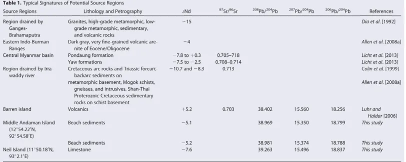
Table 1.Typical Signatures of Potential Source Regions
Source Regions Lithology and Petrography eNd 87Sr/86Sr 208Pb/204Pb 207Pb/204Pb 206Pb/204Pb References
Region drained by Ganges- Brahamaputra
Granites, high-grade metamorphic, low- grade metamorphic, sedimentary, and volcanic rocks
215 Dia et al. [1992]
Eastern Indo-Burman Ranges
Dark gray, very fine-grained volcanic are- nite of Eocene/Oligocene
24 Allen et al. [2008a]
Central Myanmar basin Pondaung formation 27.8 to10.3 0.705–718 Licht et al. [2013]
Yaw formations 27.5 to22.5 0.708–0.714 Licht et al. [2013]
Region drained by Irra- waddy river
Cretaceous arc rocks and Triassic forearc- backarc sediments on
210.7 and28.3 0.713 Colin et al. [1999]
metamorphic basement, Mogok schists, gneisses, and intrusives, Shan-Thai Proterozoic-Cretaceous sedimentary rocks on schist basement
Allen et al. [2008a]
Barren island Volcanics 15.2 0.703 38.402 15.560 18.256 Luhr and
Haldar[2006]
Middle Andaman Island (1254.220N, 9254.580E)
Beach sediments 25.1 38.969 15.350 18.799 This study
Beach sediments 25.2 38.981 15.374 18.788 This study
Neil Island (1150.180N, 932.10E)
Limestone 27.6 39.263 15.496 18.837 This study
foraminifera-rich nannofossil oozes [Collett et al., 2008] with an average bulk CaCO3content of 25 wt % [John- son et al., 2014]. The average TOC content within this interval is 1.0 wt
% and bulkd13Corgmeasurements (220&on average) are consistent with a dominance of marine organic matter [Johnson et al., 2014]. The non- carbonate sediment fraction is domi- nated by clay minerals [Phillips et al., 2014; this study]. Volcanic ash layers are abundant throughout the record below8 mbsf [Collett et al., 2008;
Rose et al., 2014]. The uppermost bio- turbated volcanic ash bed at 8.39–
8.46 mbsf is from the most recent Toba eruption at 7560.9 ka [Mark et al., 2014] and its depth in the core confirms our age model. This is based on binary relationships of the major and minor element geochemical compositions obtained by electron microprobe (EMP) analysis, which agree with previous analyses of the Toba ash [Smith et al., 2011] (support- ing information Figure S1).
2.2. Methods
In total, 27 samples (Table 3) were selected for the analysis of radio- genic Sr and Nd isotopes and 16 samples for Pb isotope analysis of the clay-size fraction. The same set of samples (27 samples) was analyzed for clay mineral assemblages. In addition, sedimentary rock and beach sediment samples obtained from Neil Island and Middle Andaman Island were analyzed to constrain the influence of the Andaman Islands as a source of sedimentary material.
To separate the clay-size fraction from the bulk sediments, we followed the procedure ofStumpf et al.
[2011]. Sediments samples were first freeze dried and the>63mm size fraction was separated by wet siev- ing. The<63mm size fractions were further processed to separate the clay-size fraction (<2mm). In a first preparation step, carbonates and organic matter were removed with acetic acid and hydrogen peroxide, followed by a triple rinse with deionized water. A centrifuge based Atterberg method was used to separate the clay-size fraction (<2mm). The required settling times were calculated with the freely available software
Figure 2.(a) LR04 global benthicd18O reference stack; (b)d18O of benthic foraminif- era (C. wuellerstorfi) and planktonic foraminifera (G. sacculifer) from NGHP Site 17. The stratigraphy of the core was established with five14C AMS dates, the youngest Toba ash, and tuning of the benthic oxygen isotope record to the LR04 stack [Lisiecki and Raymo, 2005]. This correlation was established graphically usingAnalyseries[Paillard et al., 1996]. (c) depth (cm) versus age (kyr) plot showing sedimentation rates (cm/kyr) between radiometric control points.
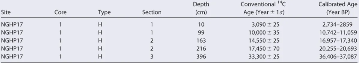
Table 2.Conventional AMS14C Ages on Hand Picked Planktonic Foraminifera From NGHP Site 17, Together With the Calibrated Calen- der Agesa
Site Core Type Section
Depth (cm)
Conventional14C Age (Year61r)
Calibrated Age (Year BP)
NGHP17 1 H 1 10 3,090625 2,734–2859
NGHP17 1 H 1 99 10,000635 10,742–11,059
NGHP17 1 H 2 163 14,550625 16,957–17,340
NGHP17 1 H 2 216 17,450670 20,255–20,693
NGHP17 1 H 3 396 33,300625 36,406–37,087
aAMS14C measurements were carried out at the Woods Hole Oceanographic Institute, USA. The radiocarbon dates were corrected, by using Calib 7.0 [Stuiver et al., 2014], for marine reservoir ages (DeltaR563.0) determined locally bySouthon et al. [2002].
SediCalc[Krumm, 2006]. The<2mm size fraction was confirmed by analyzing a subset of samples with a laser diffraction particle size analyzer (Beckman Coulter LS I3 320). Finally, the size separated samples were freeze-dried before total dissolution or XRD analysis.
About 50 mg of the dried clay-size fraction were completely dissolved using a mixture of concen- trated HF-HNO3-HClO4. The separation and purification of Sr, Nd, and Pb followed previously pub- lished procedures for Sr [Bayon et al., 2002; Horwitz et al., 1992], Nd [Barrat et al., 1996;Cohen et al., 1988;Le Fe`vre and Pin, 2005], and Pb [Galer and O’Nions, 1989;Lugmair and Galer, 1992]. Finally, Sr, Nd, and Pb isotopes were measured on a Nu Plasma MC-ICP-MS at GEOMAR, Kiel. Measured Sr iso- tope ratios were interference (86Kr,87Rb) and mass bias corrected using 86Sr/88Sr50.1194 [Steiger and J€ager, 1977]. 87Sr/86Sr results were normalized to the accepted value for NIST
NBS98750.710245. The 2r reproducibility for the NIST NBS987 standard was60.00004. Repeated processing and analysis of USGS marine sediment reference material MAG-1 (n57) gave a mean
87Sr/86Sr value of 0.72297360.00002 which agrees well with the value (0.722739) reported by Nath et al. [2009].143Nd/144Nd ratios were mass-bias corrected to 146Nd/144Nd50.7219 and normalized to the accepted value of the JNdi-1 standard of 0.512115 [Tanaka et al., 2000]. Repeated measurements of an in-house Nd standard ‘‘SPEX’’ gave a reproducibility of60.50 (2r) eNd. Repeated processing and analysis of reference material MAG-1 (n519) gave a meaneNd value of211.1960.2 which agrees well (i.e., within 36 ppm) with the values reported byNath et al. [2009]. A standard-sample bracketing method [Albare`de et al., 2004] was used to determine the Pb isotope ratios. All analyzed Pb isotope ratios were then normalized to the accepted value of the NBS981 standard of
208Pb/204Pb536.721960.0044, 207Pb/204Pb515.496360.0016, and206Pb/204Pb516.940560.0015 [Abouchami et al., 1999]. The 2r reproducibility for the NIST NBS981 standard was60.0068,60.0030, and60.0022 for 208Pb/204Pb,207Pb/204Pb, and 206Pb/204Pb, respectively. The MAG-1 standard and blanks were processed and measured together with the clay fraction samples. Blanks were typically below 200 pg so that blank contributions to the Pb analyses can be neglected. Repeated processing and analysis of MAG-1 (n54) gave a mean value62 standard deviations of 38.81060.011,
15.65660.003, and 18.86160.002 for 208Pb/204Pb, 207Pb/204Pb, and 206Pb/204Pb, respectively. These Pb isotope values agree well with those previously for MAG-1 [Nath et al., 2009].
Table 3.Nd, Sr, and Pb Isotope Data of NGHP Site 17 With 2rerror in Parentheses, Measured on<2mm Size Fraction
Site Core Type Section
Depth (cm)
Age (kyr)
eNd (60.50)
87Sr/86Sr (60.00004)
208Pb/204Pb (60.0068)
207Pb/204Pb (60.0030)
206Pb/204Pb (60.0022)
NGHP17 1 H 1 10 2.92 27.1 0.7126
NGHP17 1 H 1 20 3.81 25.8 0.7124 39.221 15.723 18.811
NGHP17 1 H 1 40 5.61 26.8 0.7119
NGHP17 1 H 1 60 7.41 26.2 0.7114 39.189 15.719 18.791
NGHP17 1 H 1 70 8.31 25.7 0.7116
NGHP17 1 H 1 100 11.01 25.6 0.7112
NGHP17 1 H 1 124 13.30 26.3 0.7126 39.134 15.711 18.781
NGHP17 1 H 2 150 15.77 25.8 0.7121 39.116 15.707 18.763
NGHP17 1 H 2 162 16.91 26.0 0.7121
NGHP17 1 H 2 186 18.61 25.8 0.7121 39.145 15.711 18.770
NGHP17 1 H 2 198 19.40 25.6 0.7119
NGHP17 1 H 2 202 19.67 25.3 0.7124 39.135 15.705 18.774
NGHP17 1 H 2 214 20.46 26.1 0.7130 39.121 15.701 18.774
NGHP17 1 H 2 226 21.49 25.6 0.7122 39.118 15.706 18.761
NGHP17 1 H 2 238 22.57 25.9 0.7118
NGHP17 1 H 2 242 22.93 25.7 0.7122 39.173 15.715 18.784
NGHP17 1 H 3 300 28.13 26.3 0.7138 39.148 15.717 18.762
NGHP17 1 H 3 310 29.03 25.7 0.7133
NGHP17 1 H 3 340 31.72 26.1 0.7119 39.112 15.703 18.756
NGHP17 1 H 3 370 34.41 26.6 0.7126 39.192 15.709 18.808
NGHP17 1 H 3 390 36.20 26.2 0.7122
NGHP17 1 H 3 400 37.08 25.3 0.7148 39.159 15.710 18.785
NGHP17 2 H 1 520 47.02 25.7 0.7124 39.055 15.702 18.748
NGHP17 2 H 2 570 51.29 26.6 0.7119
NGHP17 2 H 2 590 52.42 27.3 0.7139 39.115 15.704 18.757
NGHP17 2 H 2 610 54.87 26.9 0.7120
NGHP17 2 H 2 620 55.72 26.7 0.7126 39.153 15.709 18.788
For the clay mineral analyses, the same set of samples taken for the radiogenic isotope compositions was used. The carbonate- and organic carbon-free clay-size fraction (<2mm) was suspended in an ultrasonic bath and placed on 0.2mm filters by applying a vacuum below the filters. The XRD runs were performed fol- lowing glycol-dehydration for 24 h. The analyses were conducted using a Phillips X-Ray diffractometer (PW series) with CoKaradiation and a Ni filter under a voltage of 40 kV and an intensity of 35 mA. The relative amount of each clay mineral was estimated according to the position of the (0 0 1) series of the basal reflec- tions on the XRD diagrams, i.e., smectite (0 0 1) at 17 Å, illite (0 0 1) at 10 Å, kaolinite (0 0 1) and chlorite (0 0 2) at 7 Å. Kaolinite and chlorite were discriminated according to the relative proportions deduced from the ratios of the 3.57 and 3.54 Å peak areas. One sample was measured three times and the reproducibility of the semiquantitative clay mineral analysis was around62%.
3. Results
3.1. Sr, Nd, and Pb Isotope Compositions
Sr, Nd, and Pb isotope compositions measured on the clay-size fraction are provided in Table 3 and are dis- played in Figure 3. Nd isotope results are expressed aseNd values corresponding to the deviation of the measured143Nd/144Nd ratios of a sample from that of the chondritic uniform reservoir (CHUR50.512638), multiplied by 10,000 [Jacobsen and Wasserburg, 1980]. TheeNd values range from27.3 to25.3 for the last glacial period and27.1 to25.6 for the Holocene. The averageeNd values of26.1 and26.2 are indistin- guishable for these periods. The clay fraction208Pb/204Pb,207Pb/204Pb, and206Pb/204Pb ratios are also similar for the last glacial and the Holocene periods (Table 3 and Figure 4). In contrast,87Sr/86Sr ratios are generally more radiogenic during the last glacial period (0.712–0.715) than during the Holocene (0.711–0.712).
Figure 3.Nd, Pb, and Sr isotope compositions of clays. MIS 1, 2, and 3 denote the marine isotopic stages. Error bars represent the 2r uncertainty estimated by repeated measurement of an in-house standard during the sample measurements.
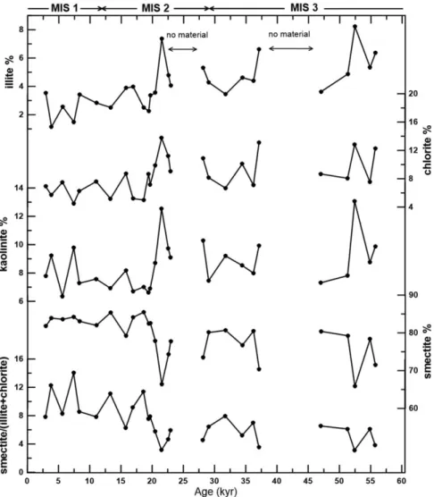
3.2. Clay Mineral Assemblages
The results of the clay mineral analyses are listed in Table 4 and shown in Figure 5. Smectite, illite, chlorite, and kaolinite are present in all analyzed samples. Smectite is the dominant clay mineral ranging from 62.5%
to 85.5% (average77%) in the glacial and 81.8% to 84.2% (average83%) for the Holocene sediments.
Illite contents vary from 2.3% to 8.2% (average5%) during the last glacial and 1.1% to 3.5% (average 3%) during the Holocene. Chlorite contents vary from 5.0% to 21.2% (average10%) and 4.5% to 7.6%
(average 6%) during the glacial and Holocene periods, respectively. The abundance of kaolinite was slightly higher during the glacial period (6.6–13.1%; average 8.8%) than during the Holocene (6.3–9.8%; average 8.0%) and varied in parallel with the illite and chlorite abundances and is mostly a consequence of dilution with smectite.
4. Discussion
4.1. Source of the Andaman Sea Sediments
Neodymium isotope signatures can provide information about the sources of the clays deposited in the Andaman Sea and here, for the first time in this area, we employ Pb isotopes as an additional constraint.
Although Pb isotopes can be affected by incongruent weathering, especially under glacial conditions [von Blanckenburg and N€agler, 2001], this is unlikely to have occurred in the tropical catchments draining into the Andaman Sea. Additionally,Garc¸on et al. [2013, 2014] found that the Pb isotope compositions of the clay-size fraction of detrital sediments reflects that of the source area because most of the lead in the clays was initially present in crustal rocks and not from heavy minerals with markedly different compositions.
Hence, the Pb isotope compositions of clays can, with some caution, be used to constrain the sources of
Figure 4.(a)207Pb/204Pb-206Pb/204Pb and (b)208Pb/204Pb-206Pb/204Pb diagrams for NGHP Site 17 clays and potential source areas in the north eastern Indian Ocean. The Pb isotope compositions of Himalayan river flood plain sediments are fromGarc¸on et al. [2013], Salween fromMillot et al. [2004], and Barren Island data are fromLuhr and Haldar[2006].
the sediments in the Andaman Sea. This is supported by radiogenic isotope results obtained from the clay- size fraction under similar environmental conditions in the eastern Indian Ocean [Ehlert et al., 2011].
TheeNd values of NGHP Site 17 clays (averageeNd5 26.2) are significantly more radiogenic than the pub- lished data for Irrawaddy River sediments (eNd5 28.3) [Allen et al., 2008a], surface sediments off the Thai- land coast (eNd5 29) [Dia et al., 1992], and bulk sediment compositions obtained from core MD77–169 in the Andaman Sea (eNd5 29.5 to210.5) [Colin et al., 1999, 2006]. On the other hand, theeNd values of Site 17 are less radiogenic than those of the clay fraction of Middle Andaman Island beach sediments
(eNd5 25.1). The fact that the data for the two Andaman Island samples studied straddle the range of val- ues found in the Site 17 sediments suggests that mainly local sources may have provided the clay-size frac- tion. However, there are no major rivers on the Andaman Islands that could provide a significant amount of sediments to the Andaman Sea. Instead the Andaman Islands consist of uplifted accretionary prism materi- als [Allen et al., 2008b;Garzanti et al., 2013] originating from uplifted Bengal/Nicobar submarine fan sedi- ments. The sediments of the eastern side of the Andaman Islands show mineralogical similarities with modern Irrawaddy River sediments revealing significant contributions from mafic/ultramafic rocks of the Burma arc-trench system [Garzanti et al., 2013]. Our measurement of the clays from a limestone sample (Neil Island) from the Archipelago Group of Miocene to Pliocene age [Allen et al., 2008a] also gives a Nd iso- tope composition (eNd5 27.6) similar to that of the Site 17 clays. There are currently only two Nd isotope measurements of Irrawaddy river sediments, at least one of which is from the upper reaches that may not be representative of the entire catchment [Allen et al., 2008b]. Fluvial clastic sedimentary rocks from the Central Myanmar basin display a wide range of Nd isotope compositions from27.8 to10.3 [Licht et al., 2013] and it is thus feasible that the Site 17 clays are sourced entirely from the Irrawaddy catchment. The fact that Site 17 clays are somewhat more radiogenic than the existing data for the Irrawaddy river implies that there has also been a small contribution from a more radiogenic source such as Barren Island. The only active volcano in the region, Barren Island consists of highly radiogenic (averageeNd5 15.2) Quaternary basalts [Luhr and Haldar, 2006]. A simple two component mass balance, usingeNd5 28.3 as the Irrawaddy River endmember andeNd5 15.2 as the Barren Island endmember, suggests a maximum of only 15% of the clays are from a radiogenic source like Barren Island. Despite the dearth of data for the Irrawaddy
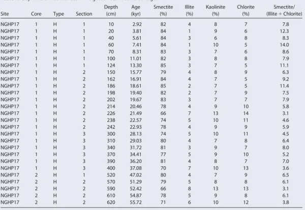
Table 4.Clay Mineral Abundances in Weighted Peak Area Percentagea
Site Core Type Section
Depth (cm)
Age (kyr)
Smectite (%)
Illite (%)
Kaolinite (%)
Chlorite (%)
Smectite/
(Illite1Chlorite)
NGHP17 1 H 1 10 2.92 82 4 8 7 7.8
NGHP17 1 H 1 20 3.81 84 1 9 6 12.3
NGHP17 1 H 1 40 5.61 84 3 6 8 8.3
NGHP17 1 H 1 60 7.41 84 1 10 5 14.0
NGHP17 1 H 1 70 8.31 83 3 7 6 8.6
NGHP17 1 H 1 100 11.01 82 3 8 8 7.9
NGHP17 1 H 1 124 13.30 85 3 7 5 11.1
NGHP17 1 H 2 150 15.77 79 4 8 9 6.3
NGHP17 1 H 2 162 16.91 84 4 7 5 9.2
NGHP17 1 H 2 186 18.61 85 2 7 5 11.4
NGHP17 1 H 2 198 19.40 82 2 7 9 7.5
NGHP17 1 H 2 202 19.67 83 3 7 7 7.9
NGHP17 1 H 2 214 20.46 78 4 9 10 5.8
NGHP17 1 H 2 226 21.49 66 7 13 14 3.1
NGHP17 1 H 2 238 22.57 74 5 10 11 4.6
NGHP17 1 H 2 242 22.93 78 4 9 9 5.9
NGHP17 1 H 3 300 28.13 74 5 10 11 4.5
NGHP17 1 H 3 310 29.03 80 4 7 8 6.4
NGHP17 1 H 3 340 31.72 81 3 9 7 8.0
NGHP17 1 H 3 370 34.41 77 5 9 10 5.2
NGHP17 1 H 3 390 36.20 81 4 8 7 7.0
NGHP17 1 H 3 400 37.08 70 7 10 13 3.6
NGHP17 2 H 1 520 47.02 80 4 7 9 6.5
NGHP17 2 H 2 570 51.29 79 5 8 8 6.1
NGHP17 2 H 2 590 52.42 66 8 13 13 3.1
NGHP17 2 H 2 610 54.87 78 5 9 8 6.1
NGHP17 2 H 2 620 55.72 71 6 10 12 3.8
aThe reproducibility of the semiquantitative clay mineral analysis is about62%.
catchment, the lack of variability in the NGHP Site 17 Nd isotope compositions suggests a stable source of clays transported to the Andaman Sea during the past 60 kyr.
Binary relationships of208Pb/204Pb-206Pb/204Pb and207Pb/204Pb-206Pb/204Pb also suggest a consistent source of clay-sized fraction to the Andaman Sea during the last glacial and Holocene periods (Figure 4).
The Pb isotope mixing relationships suggest that the Barren Island volcanic rocks may be a possible end- member source [Luhr and Haldar, 2006] but cannot have contributed sufficient amounts of sediment to explain the observed clay fraction signatures. The207Pb/204Pb-206Pb/204Pb data also clearly show that the Andaman Islands cannot have been a significant contributor of clays to the core location. The Pb isotope compositions of the Andaman Sea clays suggest they may contain components of Himalayan river [Garc¸on et al., 2013] and Salween river sediments [Millot et al., 2004]. However, these Pb isotope fields are not close enough to allow for a significant contribution from these rivers. Although to date, there are no Pb isotope data available from the Indo-Burman Ranges or Irrawaddy river sediments, based on the exclusion of other sources and together with the Nd isotopes, we suggest the Irrawaddy catchment (Indo-Burman Ranges and Central Myanmar basin) as the main source of the detrital sediments.
Together the Nd-Pb isotope compositions (supporting information Figure S2), therefore suggest a major and stable contribution from the Indo-Burman Ranges and Central Myanmar basin to the Andaman Sea clays resulting in little downcore variation since 60 ka. This is also in agreement with previous studies show- ing that the inputs to the Andaman Sea did not vary strongly over time [Colin et al., 1999, 2006]. However, a detrital Nd isotope record obtained on sediment core (SK-234-60), located to the northeast of NGHP Site 17
Figure 5.Clay mineral assemblages and smectite/(illite1chlorite) ratios during the last 60 kyr.
in the Andaman Sea, shows a much larger range of downcore isotopic variations (Figure 6) [Awasthi et al., 2014]. It was suggested that this variability in the relative contributions from different source areas was related to changes in the monsoon locus during some interstadials and the Holocene [Awasthi et al., 2014].
The core used in that study experienced variable sedimentation rates, which reached minimum values dur- ing the last glacial period (for details see Figure 2 ofAwasthi et al. [2014]) suggesting the variability may be related to transport processes. These changes in source contributions to core SK-234-60 (Figure 6) were most likely caused by ocean surface currents that transported sediments of Ganga-Brahamaputra origin from the Bay of Bengal across the Preparis Channel to the Andaman Sea (Figure 1). These transport proc- esses affecting the northern Andaman Sea obviously did not influence sedimentation at NGHP Site 17 and other locations further south (MD77–169) as evident from their nearly constant Nd-Pb isotope
compositions.
4.2. Clay Mineral Assemblages: A Tracer for Chemical Weathering
Illite and chlorite are considered primary detrital clay minerals [Chamley, 1989]. A high abundance of these minerals reflects decreased hydrolytic processes during continental weathering and increased rock erosion under cold and/or arid climatic conditions. In the case the Indo-Burman Ranges, illite and chlorite have most likely been produced by the physical erosion of igneous, metamorphic, and sedimentary par- ent rocks [Bender, 1983;Allen et al., 2008a]. An increase in illite and chlorite abundances during the last glacial period therefore suggests increased physical erosion in the upper reaches of the Irrawaddy basin.
Kaolinite is considered a secondary clay mineral formed under humid and warm climatic conditions by intense chemical weathering [Chamley, 1989]. However, our results show that the kaolinite content dis- plays a pattern similar to illite and chlorite in all studied samples suggesting dilution with variable amounts of the dominant smectite (Figure 5). Given that the sedimentation rates during the observed period of time were essentially constant, this suggests that also the input fluxes of illite, chlorite, and kao- linite were higher during the glacial. Smectite is also a secondary clay mineral. Warm and humid regions with less leaching predominantly produce smectite-rich soils as a residue of weathering of alumino- silicates and ferromagnesian silicate [Chamley, 1989]. In addition, the chemical weathering of basaltic rocks under various climatic conditions will produce smectite [Griffin et al., 1968]. The high content of smectite found at Site 17 is most likely the weathered residue of the volcanic dykes and ophiolitic forma- tions of the late Mesozoic-Cenozoic volcanic arc of the Indo-Burman Ranges and Central Myanmar basin [Bender, 1983;Licht et al., 2013]. In general, the smectite content of the studied samples is similar to the clay mineral records obtained in the eastern Andaman Sea [Colin et al., 1999] but higher than those of the Irrawaddy River-dominated coastal surface sediments [Bunsomboonsakul et al., 2010]. This might result from particle fractionation as smectite dominates the smallest clay mineral size fraction [Kurian et al., 2008] that is consequently transported further away from the coastal source areas to the core site. A sig- nificant influence (>15%) of the local Barren Island basalts [Luhr and Haldar, 2006] has been ruled out based on the Nd isotope composition of the clays.
Assuming local sources and transport effects have been minimal, the clay mineral assemblage and second- ary smectite to primary illite1chlorite ratios (smectite/(illite1chlorite)) recorded in the Andaman Sea can
Figure 6.Nd isotope time series of NGHP Site 17 clays compared with cores SK-234-60 [Awasthi et al., 2014] and MD77–176 [Colin et al., 2006].
be used as a proxy of chemical weathering intensity. This will reflect the balance between physical erosion and chemical weathering in the Irrawaddy catchment (IBR, Central Myanmar basin). The smectite content and smectite/(illite1chlorite) ratios follow the glacial-interglacial cyclicity with significantly lower ratios dur- ing the glacial period and higher ratios during the Holocene (Figure 5). Although the resolution of our record (2 kyr) makes it difficult to clearly resolve millennial scale variability, there are clear indications of lower smectite content and lower smectite/(illite1chlorite) ratios during times associated with the Heinrich intervals. This implies that more intense physical erosion prevailed in the Irrawaddy catchment during the colder glacial and stadial periods although the relative timing is difficult to interpret.
4.3.87Sr/86Sr Ratios Tracing the Intensity of Chemical Weathering
The Sr isotope composition of detrital sediments is predominantly controlled by grain-size sorting during transport, changes in the source region, and the intensity of chemical weathering on land [Meyer et al., 2011;T€utken et al., 2002]. We have separated the clay-size fraction (<2mm) to minimize the effect of sedi- ment sorting during transport, acknowledging that some sorting of the fine fraction has most likely already occurred in the catchment of the river and during riverine transport. The Nd and Pb isotope compositions indicate essentially constant source areas over the past 60 kyr suggesting little influence of source region changes on the studied sediment composition during this period. Therefore, the Sr isotope compositions of the carbonate and organic matter free clay fraction indicate changes of the incongruent weathering of the silicate rocks in the source region [Taylor and Blum, 1995].Colin et al. [2006] demonstrated the variation of Sr isotope compositions in Andaman Sea sediments is independent of the source of the sediments, the dis- tance from the source river mouth, and grain-size sorting effects. These authors further suggested that an increase in87Sr/86Sr ratios corresponded to the intensification of physical erosion in the Irrawaddy River catchment caused by enhanced release of unaltered minerals such as mica with high87Sr/86Sr ratios. The Sr isotopic composition of the clay-size fraction from Site 17 is lower than that of the bulk sediments in the Andaman Sea [Colin et al., 2006]. This deviation is most likely simply caused by minor contributions from less radiogenic sources (e.g., Barren Island, Table 1). The trend displayed by the Sr isotope composition of clays and the bulk sediments is similar between the Holocene and glacial periods with glacial sediments characterized by higher87Sr/86Sr ratios than Holocene sediments.
The clay87Sr/86Sr record displays a glacial-interglacial variability similar to the clay mineral assemblages (Figure 7), indicating more intense physical erosion during glacial period. Although the record is too coarse in resolution and the age model is not precise enough to unambiguously resolve millennial scale variability, higher87Sr/86Sr ratios generally appear to have been associated with cold stadials, in particular Heinrich events H3, H4, and H5a. Consistent with the clay mineral variations this also points to enhanced physical erosion under drier conditions and relatively low chemical weathering intensity. However, unlike the clay mineral composition, the87Sr/86Sr ratios of the clays did not change during Heinrich stadial H1, suggesting a lower sensitivity of the Sr isotopes to weathering intensity compared to the clay mineral assemblages (Fig- ure 7) under full glacial conditions. This is most likely a consequence of the clay mineral assemblages and Sr isotope compositions being affected by weathering intensity and source rock composition in different ways, and not in a linear manner.
4.4. Variability of the South Asian Monsoon in the Irrawaddy Catchment
The Site 17 clay fraction documents the variability of the South Asian summer monsoon during the last gla- cial and Holocene (Figure 7). An increased chemical weathering intensity during the Holocene period indi- cates a stronger South Asian summer monsoon over the Irrawaddy catchment, consistent with other proxy records obtained in the Andaman Sea [Colin et al., 1999, 2006].Rashid et al. [2007, 2011] presented a millennial-scale salinity record from core RC12-344 in the Andaman Sea that shows lowered sea surface salinity caused by increased South Asian summer monsoon rainfall during the early Holocene. An increase in continental wetness during the Holocene has also been inferred from thed18O ofG. ruberfrom the north- ern Andaman Sea [Marzin et al., 2013]. The higher87Sr/86Sr ratios since6 ka were most likely caused by a weakening of the South Asian summer monsoon following a maximum in monsoon intensity during the early Holocene.
The Andaman Sea clay record also suggests relatively rapid changes in physical erosion and chemical weath- ering as inferred from the variations in the smectite/(illite1chlorite) and Sr isotope ratios. Higher physical erosion occurred around16,22,29, and37 ka. Although our age model and sampling resolution do
not permit unambiguous comparison, there seems to be a broad correspondence to the Heinrich cold events H1 to H4 (16.8, 24, 31, and 38 ka, respectively) as recorded in North Atlantic deep sea sediment cores [Hem- ming, 2004, and reference therein]. The occurrence of the observed rapid episodes of higher physical erosion in our record may support a connection between weathering regime and the South Asian monsoon intensity in the Irrawaddy catchment and northern hemisphere millennial variability, as previously suggested for other regions [e.g.,Kudrass et al., 2001]. A minimum in smectite/(illite1chlorite) and higher87Sr/86Sr ratios docu- ment an episode of high physical erosion52 ka which may correspond to Heinrich event H5a recorded in the Labrador Sea, the North Atlantic, and off northeast Brazil [Rashid et al., 2003;Jaeschke et al., 2007]. The
Figure 7.Smectite/illite1chlorite, Sr isotope composition from NGHP Site 17 (cf. Figures 3 and 5) compared with the Chemical Index of Alteration (CIA) [Colin et al., 1998] of Core MD77–180 from the Bay of Bengal, seawaterd18O anomaly [Marzin et al., 2013] of Core MD77–
169 from the Andaman Sea,d18O records [Wang et al., 2001] of Hulu cave stalagmites and the Zr/Al record [Deplazes et al., 2014] of Core 289KL from the Arabian Sea. MIS 1, 2, and 3 denote the marine isotopic stages and the vertical bars show the ages of Heinrich events H1–
H4 [Hemming, 2004], as well as of Heinrich event H5a [van Kreveld et al., 2000;Rashid et al., 2003].
other weathering proxy records obtained from the Bay of Bengal (Chemical Index of Alteration results in Fig- ure 7) [Colin et al., 1998] also indicate a weaker South Asian monsoon associated with Heinrich intervals. The record of the monsoon-forced biological productivity in the northwestern Arabian Sea suggest a weak South Asian summer monsoon during the Heinrich events of the North Atlantic Ocean [Schulz et al., 1998;Schulte and M€uller, 2001;Deplazes et al., 2014]. Furthermore, a weak Asian summer monsoon during the last glacial Heinrich intervals is also suggested by thed18O of speleothems from Indian (Timta), and Chinese (Songjia, Dongge and Hulu) caves [Wang et al., 2001;Pausata et al., 2011, and references therein].
The overall pattern of the clay mineral assemblages and Sr isotope ratio records agree well with other chemical weathering records from the region (e.g., CIA; Figure 7) [Colin et al., 1998] but the timing of the weaker monsoon events during the glacial differs from that of the sea surface temperature records obtained from the northern Andaman Sea [Marzin et al., 2013], thed18O from the Hulu cave speleothem in China [Wang et al., 2001], and aeolian dust records (Zr/Al) from the Arabian Sea [Deplazes et al., 2014].
Although the resolution of our records makes this hard to interpret, there appears to be a delay in the weathering response to weaker monsoon intervals. This time lag of a thousand years or more possibly results from the time needed to transport clays from the location of physical erosion during a period of drier climate.
In summary, the proxy records of physical erosion and chemical weathering indicate that the intensity of the South Asian summer monsoon over the Irrawaddy catchment may have been linked to the climatic pat- terns of the North Atlantic Ocean. However, an unambiguous relationship between South Asian monsoon- related changes in weathering intensity and northern hemisphere millennial scale climatic variability cannot be evaluated here due to the insufficient of the precision of the age model and low sample resolution.
5. Conclusions
The radiogenic Nd and Pb isotope compositions of the detrital clay-size fraction of the NGHP Site 17 in the Andaman Sea show that over the past 60 kyr detrital clays were mainly sourced from the Irrawaddy catch- ment including the Indo-Burman Ranges with a minor contribution from nearby local sources (Andaman Islands, Barren Island). This suggests that the monsoon over the Irrawaddy catchment was spatially stable during the last glacial and deglaciation. The clay mineral assemblages and Sr isotope compositions of the clays mainly reflect changes in physical erosion and chemical weathering. High smectite contents and smectite/(illite1chlorite) ratios and relatively low radiogenic87Sr/86Sr ratios of the clays document that a stronger monsoon intensity prevailing during the early Holocene compared to the last glacial period. Dur- ing the glacial distinct minima in smectite/(illite1chlorite) ratios and peak radiogenic Sr isotope signatures mark short periods of weaker South Asian monsoon intensity and drier conditions in the source areas of the sediments. These dry events in the Irrawaddy catchment were possibly linked to the northern hemisphere Heinrich cold events, although this cannot be unambiguously proven based on the currently available data and the limitations of the age model.
References
Abouchami, W., S. J. G. Galer, and A. Koschinsky (1999), Pb and Nd isotopes in NE Atlantic Fe-Mn crusts: Proxies for trace metal paleosour- ces and paleocean circulation,Geochim. Cosmochim. Acta,63, 1489–1505.
Ahmad, S. M., G. Anil Babu, V. M. Padmakumari, A. M. Dayal, B. S. Sukhija, and P. Nagabhushanam (2005), Sr, Nd isotopic evidence of terrig- enous flux variations in the Bay of Bengal: Implications of monsoons during the last34,000 years,Geophys. Res. Lett.,32, L22711, doi:
10.1029/2005GL024519.
Albare`de, F., P. Telouk, J. Blichert-Toft, M. Boyet, A. Agranier, and B. Nelson (2004), Precise and accurate isotopic measurements using multiple-collector ICPMS,Geochim. Cosmochim. Acta,68, 2725–2744.
Allen, R., et al. (2008a), New constraints on the sedimentation and uplift history of the Andaman-Nicobar accretionary prism, South Anda- man Island,Geol. Soc. Am. Spec. Pap.,436, 223–255.
Allen, R., Y. Najman, A. Carter, D. Barfod, M. J. Bickle, H. J. Chapman, E. Garzanti, G. Vezzoli, S. Ando, and R. R. Parrish (2008b), Provenance of the Tertiary sedimentary rocks of the Indo-Burman Ranges, Burma (Myanmar): Burman arc or Himalayan-derived?,J. Geol. Soc.,165, 1045–1057.
An, Z. (2000), The history and variability of the East Asian paleomonsoon climate,Quat. Sci. Rev.,19(1–5), 171–187.
Awasthi, N., J. S. Ray, A. K. Singh, S. T. Band, and V. K. Rai (2014), Provenance of the Late Quaternary sediments in the Andaman Sea: Impli- cations for monsoon variability and ocean circulation,Geochem. Geophys. Geosyst.,15, 3890–3906, doi:10.1002/2014GC005462.
Barrat, J. A., F. Keller, J. Amosse, R. N. Taylor, R. W. Nesbitt, and T. Hirata (1996), Determination of rare earth elements in sixteen silicate refer- ence samples by ICP-MS after Tm addition and ion exchange separation,Geostand. Newsl.,20, 133–139.
Acknowledgments
Part of this work was funded by German Science Foundation (DFG), grant HA5751/3-1. Jutta Heinze is thanked for her help in the laboratory and XRD measurements. Nabil Khelifi is highly thanked for constructive discussions and suggestions during the preparation of the paper. All data used in the figures are either presented in the tables (our data) or their source publications have been referenced.
![Figure 6. Nd isotope time series of NGHP Site 17 clays compared with cores SK-234-60 [Awasthi et al., 2014] and MD77–176 [Colin et al., 2006].](https://thumb-eu.123doks.com/thumbv2/1library_info/5493734.1685326/11.944.352.803.146.355/figure-isotope-series-nghp-site-compared-awasthi-colin.webp)
![Figure 7. Smectite/illite 1 chlorite, Sr isotope composition from NGHP Site 17 (cf. Figures 3 and 5) compared with the Chemical Index of Alteration (CIA) [Colin et al., 1998] of Core MD77–180 from the Bay of Bengal, seawater d 18 O anomaly [Marzin et al.,](https://thumb-eu.123doks.com/thumbv2/1library_info/5493734.1685326/13.944.306.844.146.877/smectite-chlorite-composition-figures-compared-chemical-alteration-seawater.webp)
