RESEARCH ARTICLE
10.1002/2017GC006813
Geological interpretation of volcanism and segmentation of the Mariana back-arc spreading center between 12.78N and 18.38N
Melissa O. Anderson1,2 , William W. Chadwick Jr.3 , Mark D. Hannington1,2, Susan G. Merle3 , Joseph A. Resing4, Edward T. Baker4 , David A. Butterfield4, Sharon L. Walker5, and
Nico Augustin2
1Department of Earth Sciences, University of Ottawa, Ottawa, Ontario, Canada,2GEOMAR, Helmholtz Centre for Ocean Research Kiel, Kiel, Germany,3Cooperative Institute for Marine Resources Studies, Oregon State University and NOAA- PMEL, Hatfield Marine Science Center, Newport, Oregon, USA,4Joint Institute for the Study of Atmosphere and Ocean, University of Washington and NOAA-PMEL, Seattle, Washington, USA,5National Oceanic and Atmospheric Administration Pacific Marine Environmental Laboratory (NOAA-PMEL), Seattle, Washington, USA
Abstract
The relationships between tectonic processes, magmatism, and hydrothermal venting along 600 km of the slow-spreading Mariana back-arc between 12.78N and 18.38N reveal a number of similari- ties and differences compared to slow-spreading mid-ocean ridges. Analysis of the volcanic geomor- phology and structure highlights the complexity of the back-arc spreading center. Here, ridge segmentation is controlled by large-scale basement structures that appear to predate back-arc rifting.These structures also control the orientation of the chains of cross-arc volcanoes that characterize this region. Segment-scale faulting is oriented perpendicular to the spreading direction, allowing precise spreading directions to be determined. Four morphologically distinct segment types are identified: dom- inantly magmatic segments (Type I); magmatic segments currently undergoing tectonic extension (Type II); dominantly tectonic segments (Type III); and tectonic segments currently undergoing magmatic extension (Type IV). Variations in axial morphology (including eruption styles, neovolcanic eruption vol- umes, and faulting) reflect magma supply, which is locally enhanced by cross-arc volcanism associated with N-S compression along the 16.58N and 17.08N segments. In contrast, cross-arc seismicity is associ- ated with N-S extension and increased faulting along the 14.58N segment, with structures that are inter- preted to be oceanic core complexes—the first with high-resolution bathymetry described in an active back-arc basin. Hydrothermal venting associated with recent magmatism has been discovered along all segment types.
1. Introduction
The Mariana back-arc in the western Pacific is a slow-spreading center with highly complex tectonics with variable magmatic and hydrothermal activity (Figure 1). Processes of crustal accretion in the Mariana back-arc share some similarities with the Mid-Atlantic Ridge, both being characterized by strong ridge segmentation along large shear zone offsets and nontransform ridge-axis discontinuities. Individ- ual segments on slow-spreading ridges may exhibit several important variations along strike: (1) increased magmatic activity toward the center of the segment, (2) increased crustal thickness toward the ends of the segment, and (3) increased fault size toward the ends of the segment [e.g.,Devey et al., 2010]. However, ridges associated with back-arc spreading have additional complexities resulting from oblique subduction, irregular trench geometries, strongly asymmetric spreading, subduction-zone colli- sions, slab reorientation, variations in spreading rates, and variable contributions of arc magmas [e.g., Jenner et al., 1987;Vallier et al., 1991;Taylor, 1995;Stern, 2002;Kato et al., 2003;Stern, 2010;Stern et al., 2013]. The structure of the Mariana back-arc is highly variable and reflects a number of these effects; for example, deep axial valleys with variable depths and cross-sectional morphologies north of 13.68N ver- sus axial volcanic ridges lacking valleys and resembling fast-spreading centers such as the East Pacific Rise south of 13.68N [Fryer, 1995;Martınez et al., 2000;Deschamps and Fujiwara, 2003;Deschamps et al., 2004;Asada et al., 2007].
Key Points:
Ridge segmentation is controlled by preexisting basement structures
Spreading is perpendicular to the back-arc axis, allowing precise spreading directions to be determined
Segment morphology reflects magma supply, which is locally enhanced by proximity to cross-arc volcanoes
Supporting Information:
Supporting Information S1
Correspondence to:
M. O. Anderson, mande082@uottawa.ca
Citation:
Anderson, M. O., W. W. Chadwick, Jr., M. D. Hannington, S. G. Merle, J. A. Resing, E. T. Baker, D. A. Butterfield, S. L. Walker, and N. Augustin (2017), Geological interpretation of volcanism and segmentation of the Mariana back-arc spreading center between 12.78N and 18.38N,Geochem. Geophys. Geosyst.,18, 2240–2274, doi:10.1002/
2017GC006813.
Received 11 JAN 2017 Accepted 26 MAR 2017
Accepted article online 23 MAY 2017 Published online 23 JUN 2017
VC2017. American Geophysical Union.
All Rights Reserved.
Geochemistry, Geophysics, Geosystems
PUBLICATIONS
Early investigations of the Mariana region were driven by the discovery of hydrothermal activity in the cen- tral back-arc during a series ofAlvindives in 1987, which located the Alice Springs (including Central Peak), Burke (including Snail Pits and Anemone Heaven), and Illium vent fields near 18812’N, and the Central Trough vent field near 1882’N [Craig et al., 1987;Campbell et al., 1987;Hessler et al., 1988;Hessler and Martin, 1989;Hessler and Lonsdale, 1991,Gamo and Shipboard Scientific Party, 1993;Fujikura et al., 1997; Ishibashi et al., 2015]. Venting was subsequently discovered in the southern back-arc near 138N, beginning with the Forecast Seamount vent field in 1992 [Johnson et al., 1993;Gamo and Shipboard Scientific Party, 1993], the 138N Ridge low-temperature vent field in 1999 [Mitsuzawa et al., 2000;Masuda et al., 2001], the Snail (also known as the ‘‘Fryer’’ site), Yamanaka (also known as the ‘‘Y’’ site), Pika, and Archean (3030–2980 mbsl) vent fields in 2003, and the Urashima vent field in 2010 [Wheat et al., 2003;Ishibashi et al., 2004; Urabe et al., 2004;Baker et al., 2005;Kakegawa et al., 2008;Yoshikawa et al., 2012;Nakamura et al., 2013;Ikehata et al., 2015]. However, the regional geological context of the different vent sites was poorly understood.
Here, we use nearly continuous high-resolution multibeam bathymetry collected by theR/V Falkorexpedi- tion FK151121 (20 November to 17 December 2015) over600 km of the Mariana back-arc spreading axis between138N and188N to assess the large-scale variations in axial morphology, and the relationships between tectonic processes, faulting, magma supply, and hydrothermal activity [Resing and Shipboard
Figure 1.Tectonic setting of the Mariana subduction zone, overlain on regional bathymetry (GMRT v.3.2) [Ryan et al., 2009]. Ages of oceanic crust are fromBouysse et al.[2010] and refer- ences therein. Seafloor fractures are fromMatthews et al. [2011] andWessel et al. [2015]. Subduction rates are relative to the Philippine Plate, fromdeMets et al. [2010]. MP5Mariana Microplate.
Scientific Party, 2016;Baker et al., 2016]. The study area is divided into 11 segments, separated by first, sec- ond, and third-order discontinuities. We identify four morphologically distinct segment types, reflecting var- iable magma supply and structural evolution along the back-arc. We discuss the relationships between these features and the influence on hydrothermal venting. We also investigate the regional controls on ridge segmentation, and the effect of cross-arc structures on segment morphologies. Finally, segment-scale fault orientations are measured to reveal precise spreading directions along the Mariana back-arc.
2. Tectonic Setting
The2800 km long Izu-Bonin-Mariana (IBM) trench is characterized by the oblique subduction of some of the oldest oceanic lithosphere in the world, ranging in age from Early Cretaceous in the north and to Mid- Jurassic along the Mariana trench (Figure 1) [Jarrard, 1986;M€uller et al., 1997;Stern et al., 2003]. The relative motions of the Pacific plate and the Philippine Sea plate result in a southward decrease in convergence rates along the IBM [deMets et al., 1994]. Near the southern end of the Philippine Sea plate (88N 137818’E) [deMets et al., 1994], the Pacific plate is moving NW relative to the Mariana trench at a rate of 16–28 mm yr21, while along the Izu Bonin trench the Pacific plate is moving WNW at a rate of 40–49 mm yr21(Figure 1) [deMets et al., 2010]. Several phases of clockwise rotation of the Philippine Sea plate, beginning in the Eocene, affected the region [Uyeda and Ben-Avraham, 1972;Koyama et al., 1992;Hall et al., 1995;Sdrolias et al., 2004], first with the northward migration of the Izu-Bonin trench and opening of the West Philippine back-arc basin between 55 and 33–30 Ma (Figure 1) [Hilde and Lee, 1984;Deschamps and Lallemand, 2002]. By 30–15 Ma, the Izu-Bonin trench had migrated almost1000 km to the north, accompanied by the opening of the Shikoku basin, while the Mariana trench migrated400 km to the north, accompanied by the opening of the Parece Vela basin (Figure 1) [Seno and Maruyama, 1984;Seno, 1985;Okino et al., 1998;Sdrolias et al, 2004]. At25 Ma, the arrival of much older oceanic lithosphere (110–130 Ma crust from the Pacific plate) caused southward steepening of the IBM slab that is thought to have increased back-arc spreading and trench migration [Seno, 1985; le Pichon and Huchon, 1987; Carlson and Mortera-Gutierrez, 1990]. In the late Miocene-Pliocene, subduction initiated farther south along the Philippine trench, and clockwise rotation of the Philippine Sea plate resumed, retreating from the Mariana trench faster than from the Izu-Bonin trench [Seno, 1985]. This resulted in renewed spreading in the Mariana back-arc at7 Ma, with true seafloor spreading initiating at 3–4 Ma, forming the Mariana Microplate (Figures 1 and 2) [Scott et al., 1981;Masuda et al., 1994;Martınez et al., 1995;Stern et al., 2003]. Spreading continues today in the Mariana back-arc basin, with an opening rate of 15 to 45 mm yr21, increasing southward [Kato et al., 2003;Stern et al., 2003].
Differences in the rate of trench migration in the Izu-Bonin and Mariana subduction zones correspond to different slab dips and morphologies [van der Hilst and Seno, 1993;Miller et al., 2004]. Seismic tomography indicates that the Izu-Bonin slab deflects horizontally at the 670 km discontinuity in the upper mantle, whereas the Mariana slab dips almost vertically into the lower mantle [van der Hilst and Seno, 1993;Engdahl et al., 1998;Widiyantoro et al., 1999]. The dramatic change in slab trajectory is accommodated by tearing at the junction of the Izu-Bonin and Mariana arcs [Miller et al., 2004]. A possible slab tear also has been sug- gested at the southern end of the Mariana arc, where there is a sharp curve in the Challenger Deep seg- ment [Fryer et al., 2003;Gvirtzman and Stern, 2004;Miller et al., 2006].
Several different mechanisms have been proposed to explain the modern crescent shape of the Mariana trench (Figures 1 and 2).Karig[1971a, 1971b] suggested that the shape of the back-arc and variations in spreading rate are related to the nonrigid behavior of the arc and fore arc.Bracey and Ogden[1972] sug- gested that the basin formed as a result of rifting of the arc first at the center and then progressing north- ward and southward, contributing to the crescent shape of the arc.Le Pichon et al. [1985] proposed a rigid plate model with a single pole of rotation at218N/1388E, although several studies demonstrated that a single pole cannot account for the basin geometry [Karig et al., 1978;Fryer and Hussong, 1981;Stern et al., 1984]. Most authors agree that collisions of buoyant oceanic plateaus with the IBM subduction zone effec- tively ‘‘pinned’’ the top and bottom of the Mariana trench, while continued eastward rollback at the center produced the curved shape [Vogt, 1973;Vogt et al., 1976;McCabe and Uyeda, 1983;Hsui and Youngquist, 1985;Carlson and Mortera-Gutierrez, 1990;Taylor, 1992;Scholz and Small, 1997;Miller et al., 2004;Miller et al., 2005;Wallace et al., 2005;Miller et al., 2006]. In the south at108N, the Mariana trench abuts the Caroline Ridge (Figure 1). In the north at268N, the Ogasawara Plateau (also known as the Marcus-Necker Ridge,
Figure 2.Bathymetry of the Mariana back-arc with the segment nomenclature, with data from the Global Multi-Resolution Topography Synthesis (GMRT v3.2) [Ryan et al., 2009], the FK151121 expedition aboard theR/V Falkorin 2015 [Resing and Shipboard Scientific Party, 2016], and the EX1605L1–2 expeditions aboard theR/V Okeanos Explorerin 2016 [Gray, 2016;
Lobecker, 2016]. Yellow stars indicate hydrothermal vent sites discovered along the back-arc fromResing and Shipboard Scientific Party[2016] andBaker et al. [2016]. ASVP5Alphabet Seamount Volcanic Province; FN5Fina Nagu volcanic complex; MGR5Malaguana-Gadao Ridge.
Michelson Ridge, or Mid-Pacific Mountains) occurs at the junction between the Izu-Bonin and Mariana trenches (Figure 1). Trench modification by collision of oceanic plateaus is supported by the three- dimensional numerical modeling ofMason et al. [2010], and is currently the most widely accepted explana- tion for the highly arcuate shape of the Mariana trench.
DeMets et al. [2010] showed that extension in the back-arc is associated with the eastward displacement of the Mariana trench at20 mm yr21relative to the Philippine plate. The southern segments of the Mariana back-arc have full-spreading rates of 45 mm yr21[Kato et al., 2003]. The central segments have slow spread- ing rates of 25–40 mm yr21[Kato et al., 2003], and the spreading is 2–3 times faster to the west than to the east [Deschamps and Fujiwara, 2003]. In the central Mariana back-arc near 188N,Fryer[1981] noted a major difference in seafloor morphology between the western and eastern sides of the basin. The western side is characterized by extensively block-faulted terrain over 60 km in width, whereas the eastern side contains evenly spaced ridges and troughs that resemble abyssal hill morphologies adjacent to the active spreading axis (Figure 2).Fryer[1981] suggested that this morphology resulted from a two-stage evolution of the back-arc basin, with initial stretching and collapse of the arc during the first few million years of extension producing the block-faulted terrain, followed by a transition to true seafloor spreading producing the ridge- transform morphology. Major fracture zones (deep valleys that extend across the back-arc region) were originally identified byKong[1993], andHawkins et al. [1990] described numerous minor discontinuities in the back-arc spreading axis. Near the back-arc spreading center, these fracture zones are associated with major ridge offsets that display a strong sinistral shear component (referred to here as shear zone offsets, or SZOs), and are highly oblique to the spreading axis, unlike transform fractures at mid-ocean ridges. The morphology of the seafloor also varies considerably between the northern, central, and southern parts of the back-arc (Figure 2) [Fryer and Hussong, 1981;Hussong and Uyeda, 1981;Macdonald, 1982;Sinton and Hussong, 1983;Kong et al., 1992;Seama and Fujiwara, 1993;Fryer, 1995;Baker et al., 1996;St€uben et al., 1998;
Martınez et al., 2000;Deschamps and Fujiwara, 2003;Deschamps et al., 2004;Asada et al., 2007]. The slow- spreading morphology of the central segment is thought to correspond to a greater crustal thickness in this region of 4–7 km [Ambos and Hussong, 1982;Bibee et al., 1980;LaTraille and Hussong, 1980;Sinton and Hus- song, 1983]. In the north (218N to 228N latitude), the full-spreading rate is even slower, at10–15 mm yr21 [Yamazaki et al., 1993]. Progressive changes in isotopic and geochemical compositions of basaltic glasses along the length of the Mariana back-arc were reported byGribble et al. [1996] andGribble et al. [1998], who identified a mature arc component with increased partial melting in the northernmost rift compared to the
‘‘true’’ back-arc basin basalts of the central back-arc. The proportion of the subduction component also decreases southward in the central back-arc [Gribble et al., 1996].
A notable feature of the Mariana back-arc is the occurrence of cross-arc chains of volcanoes that extend westward from the presently active volcanic arc and are also present on the remnant arc [Fryer and Hus- song, 1982; Dixon and Stern, 1983;Fryer, 1995;Heeszel et al., 2008;Stern et al., 2014]. Several of these
‘‘cross-arc chains’’ are seismically active [Heeszel et al., 2008]. Near the active volcanic arc, these struc- tures are undergoingN-S extension [Heeszel et al., 2008], consistent with GPS measurements of the islands, which are moving apart in a N-S direction [Kato et al., 2003]. The regime where the cross-arc chains are located shifts from extension at the volcanic front to compression further to the west, reflect- ing the stresses associated with the bend in the arc [Heeszel et al., 2008].Fryer and Hussong[1982] sug- gested the volcanism associated with the cross-arc chains results from a complex interaction of preexisting structures, fore-arc tectonics, arc magmatism, and back-arc rifting. Here, we examine these structures and their role in back-arc segmentation, segment morphology, and magmatism in the south- ern and central back-arc.
3. Methods
Ship-based multibeam bathymetric data from the active Mariana back-arc was collected during the R/VFal- korexpedition FK151121 [Resing and Shipboard Scientific Party, 2016] and the R/VOkeanos Explorerexpedi- tion EX1605L1–2 [Gray, 2016;Lobecker, 2016], as shown in Figure 2. TheFalkorand theOkeanos Explorer were both equipped with Kongsberg Maritime EM 302 multibeam echo sounders with operating frequen- cies of 30 kHz, capable of mapping seawater depths of up to 7000 m. The data were gridded with a cell size of 40 m. To create geological maps of the active back-arc spreading center, the bathymetric data were
interpreted with the aid of acoustic backscatter, slope shading, and rugosity and were further processed using the ‘‘Terrain Texture Shading’’ (TTS) technique (supporting information Figure S1) developed byBrown [2010]. Terrain Texture Shading combines traditional hill shading with curvature analysis to add texture to shaded relief [e.g.,Kennelly, 2008;Kennelly and Stewart, 2014; Augustin et al., 2016]. This technique can increase the contrast of geological and structural features, and has recently been applied to bathymetric data in different tectonic settings [e.g.,Anderson et al., 2016;Augustin et al., 2016].
We identified 11 separate segments along the Mariana back-arc spreading center that are between 33 and 82 km long and6–25 km wide (Figure 2). The mapped segments are between 12852’N and 18836’N and cover an area of23,250 km2. Individual segments are separated by first and second-order discontinuities, including three major shear zone offsets and numerous minor discontinuities. These include overlapping spreading centers (OSCs) and deviations in axial linearity (DEVALS) defined by sharp changes in spreading axis orientation with very little offset. Both OSCs and DEVALs are characterized by zones of discordant topography and highly variable structural orientations. Compared to previous work on the segmentation of the Mariana back-arc spreading center bySt€uben et al. [1998], this study provides higher-resolution bathym- etry, improved geographical precision, and a more precise identification of the spreading axis, leading to a better understanding of the relationships between geological units and the nature of the ridge offsets. The eight ridge segments identified bySt€uben et al. [1998] broadly correlate with the segments identified here (Figure 2): segment 1 [St€uben et al., 1998]5the 17.08N segment [this study]; segments 2, 3, and 4 [St€uben et al., 1998] are likely misidentified and occur to the west of the 16.58N segment [this study]; segment 5 [St€uben et al., 1998]5the 16.18N segment [this study]; segment 6 [St€uben et al., 1998]5the 15.58N segment [this study]; segment 7 [St€uben et al., 1998]5the 15.18N segment [this study]; and segment 8 [St€uben et al., 1998]5the 14.58N segment [this study].
Different styles of faulting in this study were identified in the gridded bathymetry from scarps associated with high-intensity linear backscatter reflectors when facing inwards and low-backscatter shadows when facing outward. The faults were mapped with the fault scarp direction indicated, and the vertical offsets were estimated using the depth differences between two points on either side of the scarp at the center of the fault in map view. The geometry and spatial arrangement of faults, including azimuth distribution, were compiled and analyzed to distinguish areas of pure extension from those with a strike-slip component.
The map legend used in subsequent figures (also shown in supporting information Figure S2) followsAnder- son et al. [2016] and is based on established classifications of volcanic geomorphology and seafloor struc- ture [cf.,Walker, 1993;Thouret, 1999;Sigurdsson, 2000]. Interpretation of map units was based on ground- truth data from earlier observations made during submersible dives withAlvinat188N in 1987 [Craig et al., 1987;Campbell et al., 1987;Hessler et al., 1988;Gamo and Shipboard Scientific Party, 1993], withShinkai 6500near138N in 1992 (Y9204 TRANSARC expedition) [Johnson et al., 1993;Gamo and Shipboard Scientific Party, 1993] and at178N in 2008 (JAMSTEC expedition YK08–08 Leg-1) [Fujiwara et al., 2008], from seafloor images captured by the towed ocean floor observation system and TV-grab between 14845’N and 17840’N during theSonneSO-69 cruise in 1990 [St€uben et al.,1998], from near-bottom photo surveys at 15.58N and 178N by AUVSentryin 2015 (expedition FK151121) [Resing and Shipboard Scientific Party, 2016], ROVDeep Discovererdives at 15.58N and 178N in 2016 (expedition EX1605L1) [Gray, 2016], and ROVSuBastiandives at 15.58N, 178N, and 188N in 2016 (expedition FK161129) [Butterfield et al., 2017] (Figure 3). Comparisons with ground-truthed acoustic backscatter in other similar studies [e.g.,Yeo et al., 2012, 2016;Anderson et al., 2016] provide additional confidence in our interpretations. Relative ages of the geological units were inter- preted from overlapping relationships and sediment cover from backscatter intensity [cf., Hewitt et al., 2010]. All contacts are inferred. Hydrothermal vent sites (yellow stars, Figure 2) along the back-arc were identified during plume surveys of the FK151121 cruise [Resing and Shipboard Scientific Party, 2016;Baker et al., 2016], with seafloor observations confirming active venting during the EX1605L-1 cruise [Gray, 2016]
and the FK161129 cruise [Butterfield et al., 2017].
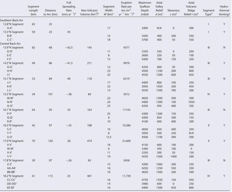
Quantitative map data are reported in terms of the parameters shown in Figure 4 and summarized in Table 1:
(1) segment length, measured along the back-arc spreading axis; (2) segment width,W, measured perpendicu- larly between the tops of the axial valley walls; (3) axial valley relief,d, measured from the deepest part of the axial valley to the highest point of the axial wall; (4) skewness,s, as the difference in height across an axial val- ley; and (5) axial volcanic ridge height,r, measured from the deepest part of the axial valley to the top of the
central volcanic ridge. These measurements were made along 31 profiles across the mapped segments of the back-arc, perpendicular to spreading direction. Cross-sectional profiles were generated in ArcGISVRv.10.1 and were drafted to include the mapped geological features.
4. Mapped Features
Despite variations in gross segment morphol- ogies, we identify the fundamental geological units that occur throughout the southern and central back-arc. These units are classified as
‘‘old BAB crust,’’ ‘‘neovolcanic terrain,’’ ‘‘volca- noes,’’ ‘‘deep sedimented basins,’’ and ‘‘struc- tures,’’ as described below, which form the basis of the legend in Figures 5–14. We pre- sent a series of geological maps along each segment to show the distribution of these fea- tures (section 5; Figures 5–14), in order to pro- vide insight into the evolution of the back-arc and the relationship between tectonics and volcanism along the spreading center.
Figure 3.Seafloor observations of lava morphologies and hydrothermal venting along the Mariana back-arc: (a) small isolated pillow lava outcrop surrounded by thick sediment (EX1605L-1 cruise; ROV dive 9) [Gray, 2016]; (b) older sedimented pillow flows overlain by young pil- low flows (FK151121 cruise; AUVSentrydive 367) [Resing and Shipboard Scientific Party, 2016]; (c) diffuse low-temperature diffuse venting emanating from a young pillow flow (FK151121 cruise; AUVSentrydive 367) [Resing et al., 2016]; (d) large pillow mound with low- temperature iron-stained hydrothermal precipitates (EX1605L-1 cruise; ROV dive 9) [Gray, 2016]; (e) sedimented ropey sheet flows that characterize the ‘‘smooth volcanic terrain’’ of the 17.08N segment (FK161129 cruise; ROV dive S41) [Butterfield et al., 2017]; and (e) jumbled sheet flows along the 17.08N segment (FK161129 cruise; ROV dive S41) [Butterfield et al., 2017].
Figure 4.Example of a cross-axis bathymetric profile with morphological parameters used in Table 1 and described in text:W5segment width, d5axial valley depth,r5axial volcanic ridge height,s5skewness.
4.1. Old BAB Crust
The axial valley walls of the central Mariana trough expose old back-arc basin (BAB) crust associated with back-arc spreading that is now at the flanks of the active spreading center. This unit is stratigraphically older than the neovolcanic products that occupy the axial valley floor. The features of the old BAB crust are classi- fied here based on the surface morphology and backscatter intensity. ‘‘Hummocky old crust’’ is character- ized by a rough surface (high rugosity), with a low to moderate slope, numerous small volcanic edifices, and minor faulting. The backscatter is uneven with a low to moderate intensity. ‘‘Faulted old crust’’ has a lower surface roughness but numerous normal faults with steep slopes identified as bright, curvilinear reflectors in otherwise low-intensity backscatter. ‘‘Sedimented old crust’’ is characterized by smooth surfaces with low relief, few normal faults, shallow slopes, and low and even backscatter intensity. The contacts between these different types of old crust are gradational. Dome-shaped bathymetric features with clear corrugated
Table 1.Morphologies and Important Features of the Back-Arc segments
Segment Length
(km)
Distance to Arc (km)
Full Spreading
Rate (mm yr21)a
Neo-Volcanic Volume (km3)b
Segment Width W(km)c
Eruption Rate per km (m3 yr21km21)b
Maximum Seafloor
Depth (mbsl)
Axial Valley Relief d(m)c
Skewness s(m)c
Axial Volcanic
Ridge Reliefr(m)c
Segment Typed
Hydro- thermal Venting?
Southern Back-Arc
12.88N Segment 65 25 I Y
A-A0 17 3400 N/A 0 500
13.38N Segment 59 25 45 I Y
B-B0 14 3450 400 200 550
C-C0 18 3700 400 50 550
Central Back-Arc
13.98N Segment 82 68 42.5 145 9377 III N
D-D0 11 3350 550 0 200
E-E0 8 3600 250 50 100
F-F0 13 4300 700 150 250
14.58N Segment 49 86 41.5 271 9979 III Y
G-G0 12 4350 600 50 300
H-H0 23 4500 1100 200 800
I-I0 25 4550 1200 600 650
15.18N Segment 33 84 40 118 6219 III N
J-J0 17 4400 800 100 250
K-K0 23 3950 1050 200 450
L-L0 13 4550 1300 700 200
15.58N Segment 34 101 38 84 3912 IV Y
M-M0 22 4650 1300 500 300
N-N0 24 4400 1300 100 1050
O-O0 25 4350 950 400 350
16.18N Segment 64 95 35 163 11143 III N
P-P0 25 4300 1200 150 350
Q-Q0 8 4200 850 300 150
R-R0 10 4100 600 400 200
16.58N Segment 42 97 32 108 10,286 II Y
S-S0 10 4050 650 400 350
T-T0 8 3950 500 250 N/A
U-U0 13.5 4500 1100 300 500
17.08N Segment 70 103 28 474 31,600 II Y
V-V0 18 4150 600 100 200
W-W0 6 3300 450 100 0
X-X0 11 3350 500 50 150
Y-Y0 19 4550 1500 1400 200
17.88N Segment 39 97 26 83 3458 III N
Z-Z0 15 4300 1000 200 250
AA-AA0 16 4250 1250 550 350
BB-BB0 10 4650 1300 200 500
18.28N Segment 61 113 25 401 11,739 IV Y
CC-CC0 16 4750 1350 150 950
DD-DD0 14 3900 600 0 250
EE-EE0 16 4400 1300 650 800
aFull spreading rates determined by GPS for some latitudes [Kato et al., 2003]; extrapolated for intervening segments (indicated by).
bSee supporting information and Table S2 for neovolcanic volume and eruption rate calculations.
cSee Figure 4 for definitions of parameters.
dSee text for segment type classification (summarized in Figure 17).
surfaces at the sides of the axial valley are interpreted here to be ‘‘oceanic core complexes,’’ similar to those now commonly found on the slow-spreading Mid-Atlantic Ridge (MAR) [e.g.,Tucholke et al., 1998;MacLeod et al., 2009]. While no sampling has been performed to confirm the presence of upper mantle rocks, these distinct bathymetric features are associated with mappable large-offset low-angle faults along the axial val- ley walls, and the corrugations on their upper surfaces extend6–7 km parallel to the direction of spread- ing. Near the tops of the core complexes, the seafloor morphology becomes more rugged with complex faulting patterns, which is consistent with observations of core complexes along the MAR, where sampling indicates that these elevated massifs are exposed magmatic crust [e.g.,MacLeod et al., 2009]. Such struc- tures are widely interpreted to form by detachment faulting in areas of extension with relatively reduced magma supply [e.g.,Buck et al., 2005].
4.2. Neovolcanic Terrain
The neovolcanic terrain occupies the central portion of the spreading axis, and can be clearly distinguished from the older BAB crust. It is dominated by high-amplitude backscatter intensity and categorized as hum- mocky, smooth, or sedimented. The ‘‘hummocky neovolcanic terrain’’ forms long, linear volcanic ridges at the center of the axial valley (axial volcanic ridges, or AVRs). Characteristic features include a high rugosity, highly variable slopes, and moderately high to high backscatter. This is interpreted to reflect multiple thick onlapping pillow and lobate flows with steep flow fronts, most likely formed by multiple diking events dur- ing phases of magmatic extension (Figure 3d) [e.g.,Yeo et al., 2012]. It is difficult to distinguish individual flows based only on backscatter (i.e., sediment cover) because of the surface roughness and numerous steep-sloped reflectors. However, an AUVSentryphoto survey from 2015 (dive 367, FK151121) [Resing and Shipboard Scientific Party, 2016] and ROV dives from 2016 (dive 9, EX1605L-1 [Gray, 2016]; dive S45, FK161129 [Butterfield et al., 2017]) reveal both young and old pillow flows (Figures 3b and 3c). The hum- mocky volcanic terrain grades locally into ‘‘smooth neovolcanic terrain,’’ which is characterized by a low rugosity, low slopes, and high even backscatter. This is interpreted to represent flat-lying sheet flows that were erupted at a higher effusion rate, and is the dominant volcanic morphology in the southern segments where it comprises the main part of the ridge axis. In the central segments, smooth neovolcanic terrain gen- erally occurs at the periphery of the hummocky flows near the axial valley walls and in deep basins. Seafloor observations during an AUVSentryphoto survey (dive 370, FK151121) [Resing and Shipboard Scientific Party, 2016] and ROV dives (dive 11, EX1605L-1; and dive S41, FK161129) [Gray, 2016;Butterfield et al., 2017] near 178N confirmed the presence of jumbled to ropy sheeted flows with minor lobate flows (Figures 3e and 3f) and numerous lava channels. ‘‘Sedimented neovolcanic terrain’’ also has a low rugosity and low slopes but is distinguished from the smooth volcanic terrain by a lower backscatter intensity. It occurs at variable dis- tances from the hummocky AVRs within the broad axial valley, and fills in topographic lows around pillow mounds (Figure 3a).
4.3. Volcanoes
Numerous volcanic edifices are found throughout the back-arc. These are classified as large rifted volca- noes, large volcanic cones, and smaller volcanic edifices. Only ‘‘small volcanic edifices’’ with diameters greater than 1 km were mapped; smaller edifices are numerous but difficult to distinguish from large hum- mocky mounds. The features that are clearly volcanoes are up to3 km in diameter and commonly have flat tops or dome shapes; obvious cones are less common. They have a clear circular shape and well- defined steep edges; some also have summit craters. They are common throughout the neovolcanic zone but also occur in hummocky old crust on the tops of the axial walls. ‘‘Large volcanic edifices’’ are4 to 16.5 km in diameter,500 to2200 m in height, and have very high relief in addition to circular shapes and steep sides. Numerous off-axis examples can be seen at 1380’N, and a particularly large cone occurs near the segment end at 16820’N. A single large ‘‘rifted-volcano’’ near 178N has a flat, circular morphology and is clearly split by the axial valley.
4.4. Deep Sedimented Basins
Deep, sedimented basins separate the ridge segments along the shear zone offsets (SZOs) and nontrans- form discontinuities at the segment ends. Near the segment centers, sedimented basins are less common and only occur distal to the spreading axis. They are low depressions with smooth bottoms and low, even backscatter interpreted to represent thick sediment cover. The sediment cover is greatest in areas of low
magmatic activity at the segment ends and away from the narrow spreading center. Faulting is rare; where present, the basins are designated ‘‘faulted basins.’’
4.5. Structures
Features with strongly linear to curvilinear traces and scarps>100 m in height are identified as ‘‘major faults’’; those with scarps<100 m high are referred to as ‘‘minor faults.’’ A total of 1664 major faults were measured with strike lengths of less than 100 m to a maximum of 8478 m; another 5148 minor faults were measured with strike lengths to a maximum of 11,540 m. Both are identified as highly reflective linear fea- tures in the backscatter data. All fault surfaces are moderately to steeply dipping (generally east-dipping on the west side of the back-arc segments and west-dipping on the east side) with apparent normal sense of movement. Some distinctive lineaments, interpreted to be eruptive fissures, occur along the AVRs. In the middle of each ridge segment, the lineaments all have similar strike directions, whereas at the segment ends they show many orientations, reflecting the structural complexity of the transfer zones.
5. Segment Geology
In this section, we describe the geology of 11 segments that comprise the active spreading center in the southern and central back-arc region (Figures 5–14). The mapped area includes two segments along the 124 km of the southern back-arc, and nine segments along 474 km of the central back-arc. The segments are named according to the latitude at the segment centers. For each segment, the cross-sectional mor- phologies are shown along profiles at the segment middle and end points. Structural azimuths are also examined, including major and minor faults and volcanic ridge axes.
5.1. Southern Mariana Back-Arc
The southern Mariana back-arc between 11850’N and 13840’N was first described in detail byMartınez et al.
[2000]. It is shallower than the central part of the back-arc (3000 mbsl along the in the south, compared to 3500–5000 m in the central back-arc), and the spreading axis approaches to within25 km of the pres- ently active arc-front volcanoes, owing to the sharp westward curvature of the trench (Figure 2). The active spreading center is morphologically similar to a fast-spreading ridge, including a broad ‘‘inflated’’ zone with a narrow axial rise (the Malaguana-Gadao Ridge), a smooth flanking morphology, and a general lack of transform offsets, despite sharp changes in the trend of the spreading center (Figure 5). The presence of a shallow axial magma chamber along the Malaguana-Gadao Ridge was documented byBecker et al. [2010].
5.1.1. The 12.88N and 13.38N Segments
The 12.88N and 13.38N segments are58 km in length and located25 km from the volcanic arc. They are morphologically similar and broadly symmetrical (low ‘‘skewness’’), with widths of14–17 km, maximum seafloor depths of3400 to3700 mbsl (increasing northwards), and500–550 m-tall axial topographic highs (Figure 5; Table 1). Profile A-A’ in Figure 5 shows topography similar to the fast-spreading EPR [cf., MacDonald, 2001]. At13810’N (profiles B-B’ and C-C’ in Figure 5), clear valley walls up to 400 m high first appear and the axial zone bears a closer resemblance to the intermediate-rate spreading segments of the EPR [cf.,MacDonald, 2001]. Along the spreading axis, the seafloor is dominated by heavily faulted but smooth and hummocky neovolcanic terrain. Minor sedimented neovolcanic terrain occurs along a narrow graben to the west of the spreading axis (Figure 5). The smooth flows are interpreted to represent the prod- ucts of volcanic eruptions close to the center of the spreading axis, with the hummocky terrain on the flanks. The latter is thought to be dominated by lobate and pillow flows, possibly related to increased magma transport along lava tubes or greater eruptive volumes along faults on the eastern side of the back- arc spreading axis. The dominant structures along the 12.88N segment have a mean orientation of 39.386 1.78(95% confidence interval; n5325; Figure 5). There is an abrupt change in the orientation at 1384’N, where an OSC has an offset of4.6 km with the 13.38N segment. The dominant structures along the 13.38N segment have a mean orientation of 23.8861.28(n5488; Figure 5). There are more outward-dipping faults on this segment, and individual faults have vertical throws of less than300 m.
5.2. Central Mariana Back-Arc
Between13840’N and 18840’N, the central Mariana back-arc more closely resembles a slow-spreading (<50 mm yr21) mid-ocean ridge. Segmentation is controlled by major SZOs, OSCs, and DEVALs. The axial valley is pronounced, with relief up to1500 m, with the highest relief at the segment ends. In cross-
section, the axial walls are highly skewed (i.e., have different heights on either side of the spreading center), and this skewness becomes more pronounced towards the segment ends. As noted by previous workers, the magmatic activity in this part of the back-arc is strongly focused at the segment centers [e.g.,Fryer and Hussong, 1981; Hussong and Uyeda, 1981; Macdonald, 1982; Martınez et al., 2000]. The axial depths are greater than on mid-ocean ridge crust of the same age, a regional characteristic of the Mariana back-arc, and the orientations of faults are more variable with a wider zone of axial deformation, indicated by recent faulting far off-axis [Fryer and Hussong, 1981;Macdonald, 1982]. The axial zone of each segment is bound by heavily faulted old BAB crust along the valley walls. Hummocky neovolcanic terrain dominates the valleys,
Figure 5.(left) Bathymetry, (middle) interpreted geological map, and (right) across-axis profiles of the 12.88N and 13.38N segments, with the segment location in the back-arc shown as a black square in the lower left map. Azimuths of the major and minor faults from 12853’N to 1384’N, and 1384’N to 13826’N are shown in blue, and the volcanic ridge axes for the entire area are shown in grey (lower right corner). ATH5axial topographic high; OSC5overlapping spreading center; V.E.5vertical exaggeration (53). A larger geological map is available in supporting information Figure S3.
forming long volcanic ridges dotted by numerous small volcanic edifices. The axial zone is variably faulted, with individual segments dominated by either recent magmatic or tectonic extension.
5.2.1. The 13.98N Segment
The 13.98N segment is82 km in length and is located68 km from the volcanic arc. It is separated from the 13.38N segment to the south by an OSC with an offset of1.8 km. The segment is characterized by a narrow (8–13 km wide) axial valley bound by faulted old crust in the west and hummocky old crust in the east (Figure 6; Table 1). The valley relief ranges from550 in the south,250 m midway along its length, and700 m in the north, with a progressive northward deepening of the seafloor (3350 mbsl to 4300 mbsl; Table 1). The valley has a low degree of skewness in cross section with<100 m
Figure 6.(left) Bathymetry, (middle) interpreted geological map, and (right) across-axis profiles of the 13.98N segment, with the segment location in the back-arc shown as a black square in the lower left map. Azimuths of the major and minor faults and the volcanic ridge axes for the entire segment from 13840’N to 14818’N are shown in blue and grey, respectively (lower right corner). DEVAL5deviation in axial linearity; V.E.5vertical exaggeration (53). A larger geological map is available in supporting information Figure S4.
height difference between the western and eastern walls (Figure 6; Table 1). The axial valley is domi- nated by hummocky and smooth neovolcanic terrain, with numerous small flat-topped volcanic edifices (Figure 6). Short volcanic ridges occur throughout the hummocky terrain. The lack of an axial volcanic high and the presence of a central graben (up to250 m deep) suggest a relatively low rate of magma supply (Figure 6). The total estimated volume of the neovolcanic products is334 km3(see supporting information for volume calculations). Intense faulting within the old crust and neovolcanic zone has a uniform orientation over the entire segment length of 15.6861.38(n5662). The maximum throw on the faults is400 m.
Figure 7.(left) Bathymetry, (middle) interpreted geological map, and (right) across-axis profiles of the 14.58N segment, with the segment location in the back-arc shown as a black square in the lower left map. Azimuths of major and minor faults and the volcanic ridge axes and for the entire segment from 14818’N to 14853’N are shown in blue and grey, respec- tively (lower right corner). AVR5axial volcanic ridge; DEVAL5deviation in axial linearity; IC5inside corner high; OCC5oceanic core complex; SZO5shear zone offset; V.E.5vertical exaggeration (53). A larger geological map is available supporting information Figure S5.
5.2.2. The 14.58N Segment
The 14.58N segment is49 km long and located86 km from the volcanic arc, offset1 km to the east from the 13.98N segment by a DEVAL. This segment is characterized by a northward deepening of the sea- floor from4350 mbsl to a maximum depth of4550 mbsl and widening of the back-arc from12 to 25 km (Figure 7; Table 1). The relief of the axial valley increases progressively from600 m in the south to 1200 m in the north (Figure 7; Table 1). The1100 m high western flank of the axial valley wall at 14840’N is interpreted to be an inside corner high (IC) [e.g.,Severinghaus and Macdonald, 1988] and oce- anic core complex (as described in section 4.1; Figure 7; Table 1). An additional complex occurs on the opposite side of the axial valley, with rough corrugations parallel to the spreading direction, and N-S
Figure 8.(left) Bathymetry, (middle) interpreted geological map, and (right) across-axis profiles of the 15.18N segment, with the segment location in the back-arc shown as a black square in the lower left map. Azimuths of the major and minor faults of the entire segment from 14859’N to 15812’N are shown in blue (lower right corner). AH5axial high; AVR5axial volcanic ridge; DEVAL5deviation in axial linearity; OCC(?)5possible oceanic core complex; SZO5shear zone offset; V.E.5vertical exaggeration (53). A larger geological map is avail- able in supporting information Figure S6.
extension indicated by an 800 m wide E-W trending graben. These features confirm the formation of core complexes in the Mariana back-arc, following the earlier discovery of upper mantle peridotites in dredge samples at 208N [Stern et al., 1996]. They the second to be identified in a back-arc basin environment based on high-resolution bathymetric features, following the discovery of the Godzilla megamullion structures in the extinct Parece Vela basin [Ohara et al., 2001]. The axial valley walls at this location are composed of heavily sedimented, faulted to hummocky old crust, and the basin floor is dominated by an 800 m high axial volcanic ridge. The heavily faulted neovolcanic terrain forming the ridge is clearly split along its axis forming a deep graben, with sedimented hummocky neovolcanic terrain in the west, and younger hum- mocky neovolcanic terrain to the east (Figure 7). Smooth neovolcanic terrain occurs only at the segment
Figure 9.(left) Bathymetry, (middle) interpreted geological map, and (right) across-axis profiles (right) of the 15.58N segment, with the segment location in the back-arc shown as a black square in the lower left map. Azimuths of the major and minor faults from 15812’N to 15833’N, and 15833’N to 15839’N are shown in blue, and the volcanic ridge axes from 14859’N to 15839’N are shown in grey (lower right corner). AVR5axial volcanic ridge; DEVAL5deviation from axial linearity; IC5inside corner high; SZO5shear zone offset; V.E.5vertical exagger- ation (53). A larger geological map is available in supporting information Figure S7.
ends. The volume of neovolcanic products in the axial valley is estimated to be271 km3(see supporting information). Fault orientations between 14810’N and 14853’N have a wide range with a mean of 16.7861.88 (n5944), parallel to the volcanic ridges (16.78616.08, n510; Figure 7). A subset of faults trendingENE forms a small graben at 14830’N/14480’E, consistent with a component of N-S extension (Figure 7). Individ- ual fault throws along this segment are up to550 m in height.
5.2.3. The 15.18N Segment
The 15.18N segment is33 km long and located84 km from the volcanic arc (Figure 8; Table 1). It is separated from the 14.58N segment by a SZO comprising a series of deep sedimented basins in a
Figure 10.(left) Bathymetry, (middle) interpreted geological map, and (right) across-axis profiles of the 16.18N segment, with the segment location in the back-arc shown as a black square in the lower left map. Azimuths of the major and minor faults from 15841’N to 15848’N, 15848’N to 16813’N, and 16813’N to 16828’N are shown in blue, and the volcanic ridge axes for the entire segment are shown in grey (lower right corner). AVR5axial volcanic ridge; OSC5overlapping spreading center; SZO5shear zone offset; V.E.5vertical exaggeration (53).
A larger geological map is available in supporting information Figure S8.
northeast-trending en echelon arrangement. The offset between the 15.18N and 14.58N segments is 31 km, and is associated with a fracture zone that extends a further57 km to the west. The axial val- ley widens from17 to23 km midway along its length and narrows to13 km in the north, but the depth is similar to the 14.58N segment, shallowing to3950 mbsl in the center (Figure 8; Table 1). The axial high is dominated by heavily faulted and sedimented hummocky neovolcanic terrain. In the south- ern portion of the segment, the neovolcanic zone is dominated by a narrow450 m tall hummocky axial volcanic ridge, with smooth and sedimented neovolcanic terrain toward the valley walls and sedimented basins (Figure 8). Axial valley relief increases northwards from800 to 1300 m, with approximately 700 m difference in height in the northern part of the segment (Figure 8, Table 1). It has a documented
Figure 11.(left) Bathymetry, (middle) interpreted geological map, and (right) across-axis profiles of the 16.58N segment, with the segment location in the back-arc shown as a black square in the lower left map. Azimuths of the major and minor faults and the volcanic ridge axes for the entire segment from 16819’N to 16854’N are shown in blue and grey, respectively (lower right corner). AVR5axial volcanic ridge; OSC5overlapping spreading center; V.E.5vertical exaggeration. A larger geological map is available in supporting information Figure S9.
spreading rate of40 mm yr21[Kato et al., 2003]. The volume of neovolcanic products is estimated to be118 km3(see supporting information). The axial walls are dominated by hummocky old crust, which contains most of the faults, having a wide range of orientations (mean of 14.6867.38, n5217; Figure 8).
The maximum throw on the faults is600 m. Subordinate E-W and NW-SE trending faults are also pre- sent. Notably corrugated surfaces at 1588’N on the western side of the valley suggest the presence of another core complex. Of all the segments studied, the 15.18N segment most closely resembles the slow-spreading MAR [e.g., near 378N:MacDonald, 2001].
Figure 12.(left) Bathymetry, (middle) interpreted geological map, and (right) across-axis profiles of the 17.08N segment, with the segment location in the back-arc shown as a black square in the lower left map. Azimuths of the major and minor faults from 16854’N to 1783’N, 1783’N to 17820’N, and 17820’N to 17827’N are shown in blue, and the volcanic ridge axes for the entire segment are shown in grey (lower right corner). AH5axial high; IC5inside corner high; OSC5overlapping spreading center; SZO5shear zone offset; V.E.5vertical exag- geration (53). A larger geological map is available in supporting information Figure S10.
5.2.4. The 15.58N Segment
The 15.58N segment is 34 km long and located101 km from the volcanic arc. It is offset from the 15.18N segment by an abrupt change in the trend of the spreading axis. The axial valley is22–25 km wide, shallowing northward from4650 to 4350 mbsl. The axial valley relief also decreases from1300 to 950 m (Figure 9; Table 1). There is a large height difference of400 m at the northeastern end of the segment forming an inside corner high (Figure 9; Table 1). The neovolcanic zone shows almost no faulting and has a tall axial volcanic ridge that rises up to1050 m above the surrounding seafloor (Figure 9). The ridge is composed of hummocky neovolcanic terrain surrounded by smooth and sedimented neovolcanic
Figure 13.(left) Bathymetry, (middle) interpreted geological map, and (right) across-axis profiles of the 17.88N segment, with the segment location in the back-arc shown as a black square in the lower left map. Azimuths of the major and minor faults from 17828’N to 17840’N, and 17840’N to 1880’N are shown in blue, and the volcanic ridge axes for the entire seg- ment are shown in grey (lower right corner). AVR5axial volcanic ridge; IC5inside corner high; OSC5overlapping spreading center; SZO5shear zone offset; V.E.5vertical exaggera- tion. A larger geological map is available in supporting information Figure S11.
terrain (Figure 9; Table 1), with an estimated total volume of84 km3(see supporting information). An AUVSentryphoto survey (dive 367) conducted during the FK151121 cruise identified newly-erupted pil- low lavas occupying an area 7.3 km long and 300–600 m in width at this spreading axis (Figure 3a) [Resing and Shipboard Scientific Party, 2016]. Two ROV Deep Discovererdives (numbers 9 and 10) during cruise EX1605L-1 and one ROVSuBastiandive (number S45) during cruise FK161121 also found multiple genera- tions of extensive pillow flows and minor lobate flows, and large steep-sided pillow mounds topped by smaller pillow mounds called ‘‘haystacks’’ (Figure 3b) [Gray, 2016; Butterfield et al., 2017]. The volcanic ridges along the axial valley have a mean orientation of 15.98613.58(n5151; Figure 9), whereas faulting
Figure 14.(left) Bathymetry, (middle) interpreted geological map, and (right) across-axis profiles of the 18.28N segment, with the segment location in the back-arc shown as a black square in the upper right map (lower left corner). Azimuths of the major and minor faults for 1880’N to 18822’N, and 18822’N to 18835’N are shown in blue, and the volcanic ridge axes for the entire segment are shown in grey (lower right corner). AVR5axial volcanic ridge; OSC5overlapping spreading center; V.E.5vertical exaggeration. A larger geological map is available in the supporting information Figure S12.
in the old BAB crust adjacent to the axial valley has a mean orientation of 7.5864.98(n5151) with throws of up to 800 m.
5.2.5. The 16.18N Segment
The 16.18N segment is64 km long and located95 km from the volcanic arc. It is offset35 km to the east by a first-order ENE-trending SZO, associated with a fracture zone that extends for164 km across the width of the back-arc. Like the other segments, it shallows northwards from4300 to 4100 mbsl (Figure 10;
Table 1). Axial relief also decreases northwards from1200 to 600 m, with a height difference of 300–
400 m between the central and northern parts of the segment (Figure 10, Table 1). The entire segment has an hourglass-shape, with the axial zone being25 km wide in the south,8 km wide in the center, and 10 km wide in the north (Figure 10; Table 1). A discontinuous axial volcanic ridge, 100–350 m in height, occupies an area of low relief at the center of the midsegment high (Figure 10). In the south, the axial volca- nic ridge is slightly offset to the east where the valley widens near the SZO. The full spreading rate is 35 mm yr21[Kato et al., 2003], and the estimated volume of the neovolcanic products is163 km3(see supporting information). The hummocky and smooth volcanics of the neovolcanic zone are moderately faulted, with throws of<100 m. Larger faults with throws of 600 m occur off-axis in the old crust between 15848’N and 16813’N and have an orientation of 2.7862.58(n5429; Figure 10), although a number of faults and ridges with different orientation are related to the radial pattern of faulting at the base of a large off- axis volcanic cone (Figure 10). The axial walls are moderately faulted hummocky and sedimented old crust (Figure 10).
5.2.6. The 16.58N Segment
The 16.58N segment is42 km long and located97 km from the volcanic arc. It is offset8.5 km to the east from the 16820’N segment by a second-order OSC. A large volcanic cone occurs at the southern end of the segment to the east of the spreading center (Figure 11). The axial zone, which also has an hourglass shape, ranges from 10 km in width in the south to 8 km in the center and 20 km in the north (Figure 11;
Table 1), shallowing from4050 mbsl in the south to3950 mbsl in the center, before rapidly deepening to4500 mbsl in the north. In the south, the axial valley is650 m deep and dominated by heavily faulted hummocky to smooth neovolcanic terrain with a300 m-tall axial volcanic ridge (Figure 11; Table 1). Mid- way along the segment, the axial valley is500 m deep and consists of unfaulted smooth volcanic terrain and large, dome-shaped volcanoes (Figure 11). In the north, it is1100 m deep and contains a500 m-tall axial volcanic ridge with minor faulting (Figure 11). The neovolcanic products along this segment have an estimated volume of108 km3(see supporting information). Faulting between 16819’N and 16854’N trends N-S, with a mean orientation of 1.0861.78 (n51161); however, the mean orientation of the volcanic ridges is closer to 174.3864.78(n543; Figure 11). The irregular axial walls consist of hummocky to sedi- mented old crust.
5.2.7. The 17.08N Segment
The 17.08N segment is70 km and located103 km from the volcanic arc. It is offset from the 16.58N seg- ment by an OSC, with a jump of8 km. The segment has a pronounced hourglass shape, with the width of the axial zone ranging from19 km in the south, to6 km in the center, and18 km in the north (Figure 12; Table 1). The axial valley is600 m deep in the south with a seafloor depth of4150 mbsl, shallowing to3300 mbsl midway along the segment where the axial valley is450 m deep. The orientation of the axial zone follows a gently sigmoidal shape, and then drops into a 1500 m deep valley at a water depth of 4550 mbsl in the north (Figure 12; Table 1). The southern neovolcanic zone occupies a broad area of unse- dimented hummocky and smooth volcanic flows separated by sedimented volcanic flows (Figure 12). The eastern half has higher backscatter intensity, suggesting that this area may be the location of a new spread- ing axis. This is supported by near-bottom side-scan surveys conducted in 2003 [Deschamps and Fujiwara, 2003;Deschamps et al., 2004;Deschamps et al., 2005;Asada et al., 2007]. There are abundant minor faults within the axial valley, but mainly within the sedimented flows and near the basin walls. The central part of the neovolcanic zone is characterized by a large, split flat-topped volcano (Figure 12). Further away from the spreading center, a second split volcano is mirrored on either side of the axial valley, indicating multiple episodes. A magma lens was imaged at this location at4 km depth in multichannel seismic surveys [Taylor et al., 2002], and the site was visited by submersible in 2008 [Fujiwara et al., 2008]. It was also the focus of an AUVSentryphoto survey during dive 370 in 2015 [Resing and Shipboard Scientific Party, 2016], and ROV dives in 2016 [Gray, 2016;Butterfield et al., 2017]. The center of the volcano is smooth and unfaulted, and multiple ROV dives revealed extensive jumbled and ropey sheet flows and minor lobate flows, indicating
high effusion rates (Figures 3e and 3f). This smooth seafloor morphology is in sharp contrast to the other segments of the central back-arc, which are dominated by hummocky axial volcanic ridges.Fujiwara et al.
[2008] observed almost no sediment in the axial portion, and our data show a decrease in backscatter inten- sity toward the eastern wall. In the northern part of the segment, the axial valley is dominated by hum- mocky neovolcanic terrain along discontinuous low-relief volcanic ridges with little faulting; smooth neovolcanic terrain occurs at the flanks (Figure 12a). The overall spreading rate of the segment is30 mm yr21[Kato et al., 2003], and the estimated volume of material within the neovolcanic zone is474 km3(see supporting information). The axial valley walls are dominated by hummocky old crust, with minor faulting (throws<100 m: Figure 12). Between 1783’N and 17820’N, faults have a mean orientation of 174.3861.88 (n5423; Figure 12). Between 17820’N and 17827’N, fault orientations are variable (mean of 179.4863.98, n5225; Figure 12), reflecting the shape of the spreading axis. North of 17820’N, an inside-corner high on the eastern flank of the valley is dominated by a large detachment fault (228dip) with a maximum throw of3000 m (Figure 12).
5.2.8. The 17.88N Segment
The 17.88N segment is39 km long and located97 km from the volcanic arc (Figure 13; Table 1). This seg- ment marks the apex of the curved subduction zone, where the back-arc is the widest. It is separated from the 17.08N segment by another SZO, with a total offset of42 km to the east. This offset is associated with the extensive Pagan Fracture Zone, which extends226 km westward across the width of the back-arc and reflects the curvature of the arc, which changes from NE-SW toN-S (Figure 2). The segment widens and deepens northward, from15 to 17 km in width and from4300–4650 mbsl (Figure 13; Table 1). The axial valley walls increase in height from1000 to 1300 m, with a 550 m height difference (‘‘skewness’) between the eastern and western axial walls in the central portion of the segment (Figure 13; Table 1). The old crust that forms the walls is heavily faulted on the west and dominated by hummocky volcanics in the east. A narrow hummocky axial volcanic ridge up to 500 m high occurs within the neovolcanic zone, sur- rounded by sedimented and smooth neovolcanic terrain (Figure 13). The total volume of neovolcanic prod- ucts is estimated to be83 km3(see supporting information). Between 17840’N and 1880’N, the major and minor faults have a mean orientation of 172.8863.68(n5386; Figure 13). The volcanic ridges follow the dominant fault orientation, with a mean orientation of 167.1863.98(n531; Figure 13).
5.2.9. The 18.28N Segment
The 18.28N segment is61 km long and located113 km from the volcanic arc. It is separated from the 17.88N segment by an OSC with a total offset of9 km to the west and occupies the widest part of the Mariana back-arc. The segment morphology has been described previously byAsada et al. [2007], and the early discovery of hydrothermal activity along this segment (Alice Springs vent field) made it the target of several investigations. It ranges in width from16 km at the segment ends to14 km in the segment cen- ter (Figure 14; Table 1), and it has a spreading rate of25 mm yr21[Kato et al., 2003]. This is the shallowest segment of the central back-arc, at 3900 mbsl, with an axial valley relief of600 m, deepening to 4400 mbsl in the south and 4750 mbsl in the north (Figure 14; Table 1). Along the southern half of the spreading segment, the axial zone is dominated by an unfaulted volcanic ridge, 800–950 m in height, comprised of hummocky volcanic terrain (Figure 14). Along the northern half of the axial zone, there is increased faulting and abundant sedimented neovolcanic terrain with a narrow hummocky volcanic ridge that is 200 m in height (Figure 14). The total volume of neovolcanic material is estimated to be401 km3(see supporting information). Between 1880’N and 18822’N, the faults have a narrow range of orientations with a mean of 168.4862.28(n5478; Figure 14), similar to the volcanic ridges (171.3865.38, n521).
6. Regional Structures
The regional bathymetry (GMRT v3.2) [Ryan et al., 2009] and the vertical gravity gradient [Sandwell et al., 2014] reveal the major structural lineaments throughout the back-arc (Figure 15a). The heavily block-faulted terrain described by previous authors that characterizes most of the back-arc bears a close resemblance to the abyssal hill fabric of slow-spreading mid-ocean ridges. The southern back-arc has fewer lineaments overall, transitioning from relatively smooth terrain over much of its width to block-faulted terrain toward the remnant arc in the west (near 14380’E at 13830’N; Figure 15). A series of N-S trending lineaments in the southern half of the back-arc, which are characterized by deep sub-parallel valleys (Figure 15a), are also seen in the northern half of the back-arc where they turn toward NW-SE, following the orientation of the
![Figure 1. Tectonic setting of the Mariana subduction zone, overlain on regional bathymetry (GMRT v.3.2) [Ryan et al., 2009]](https://thumb-eu.123doks.com/thumbv2/1library_info/5324556.1680082/2.944.125.811.147.751/figure-tectonic-setting-mariana-subduction-overlain-regional-bathymetry.webp)
![Figure 2. Bathymetry of the Mariana back-arc with the segment nomenclature, with data from the Global Multi-Resolution Topography Synthesis (GMRT v3.2) [Ryan et al., 2009], the FK151121 expedition aboard the R/V Falkor in 2015 [Resing and Shipboard Scienti](https://thumb-eu.123doks.com/thumbv2/1library_info/5324556.1680082/4.944.176.768.147.1048/bathymetry-mariana-nomenclature-resolution-topography-synthesis-expedition-shipboard.webp)
![Figure 3. Seafloor observations of lava morphologies and hydrothermal venting along the Mariana back-arc: (a) small isolated pillow lava outcrop surrounded by thick sediment (EX1605L-1 cruise; ROV dive 9) [Gray, 2016]; (b) older sedimented pillow flows overl](https://thumb-eu.123doks.com/thumbv2/1library_info/5324556.1680082/7.944.277.870.149.654/seafloor-observations-morphologies-hydrothermal-mariana-isolated-surrounded-sedimented.webp)