Dr. Marcus Dengler Meteor Reise M120
M120, Recife – Walvis Bay
October 17th to November 18th 2015 2nd Weekly Report, October 25th, 2015
During the transit from Brazil to Angola along 12°S our activities concentrated on sampling temperature and salinity profiles from the upper 400m of the water column while steaming and on chemical underway measurements of the concentration of trace gases in the near-surface waters and the atmosphere. Additionally, upper ocean velocity profiles were collected with METEOR’s two Ocean Surveyors.
Underway-CTD and current measurements along the 12°S transect
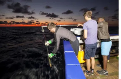
Since leaving the exclusive economic zone of Brazil eight days ago, we are collecting profiles of temperature and salinity using an underway-CTD system at a sampling rate of one profile every hour (Fig. 1). These measurements are carried out by dropping a probe with conductivity, temperature and pressure sensors into the water while METEOR is at full speed. The probe is attached to a thin tether on a winch attached to the gunwale at the stern of METEOR. Once deployed, the loosely- tethered probe descents at high velocities of 3 ms-1 to 4 ms-1 to about 400m depth.
Finally, the probe is pulled back onto the vessel using the winch.
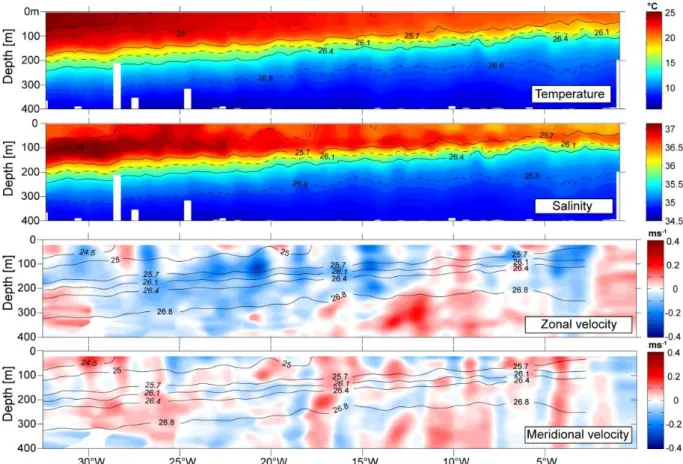
Our cruise track across the Atlantic crosses the northward flank of the southern subtropical gyre in the region of the westward flowing South Equatorial Current (SEC). The westward velocities associated with the SEC are pronounced in the already processed velocity data from the Ocean Surveyor west of about 12°W (Fig.
2). However, an intensified SEC was observed during a previous METEOR cruise M98 carried out in July 2013 that crossed the Atlantic at exactly the same latitude. A likely explanation of the observed differences in the strength of the SEC is the seasonal variability of the trade winds that are more intense during the boreal summer period compared to October in our region. The vertical distribution of temperature and salinity obtained from the underway-CTD data (Fig. 2) show a pronounced uplift of the thermocline and halocline towards the east that is also associated with a decrease in mixed-layer depth in the eastern part of the transect.
This characteristic is caused by the spatially rotating trade winds in our study area.
Fig. 1: Underway-CTD
measurements on FS METEOR.
Robert Kopte is recovering the probe after collecting a CTD profile. Amaro Francisco and Jonas Boomers are assisting by keeping the gibbet of the winch in the right position. (Photo:
Thilo Klenz)
Dr. Marcus Dengler Meteor Reise M120
Fig. 2: Temperature and salinity distribution from the underway-CTD measurements and distribution of zonal and meridional velocity from the Ocean Surveyor along the 12°S transect. Black lines indicate isopycnals in kg m-3.
Apart from the analysis of water mass changes mention in the earlier report, the data set will be used in conjunction with additional meteorological data collected by METEOR to quantitatively advance understanding of the mixed-layer heat and salt balance.
Trace gas concentrations in the near-surface waters along 12°S
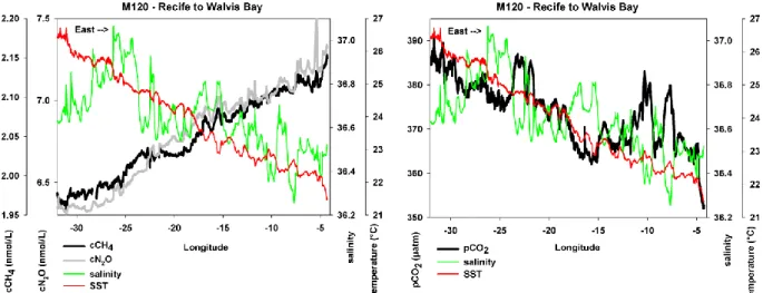
The chemical group participating in M120 collected measurements along the transit cruise track using their underway system to continuously measure concentrations of climate-relevant trace gases in the near-surface waters and the atmosphere. While searching for regions of sinks or sources of trace gases in the ocean, much of the data collected so far showed the surface ocean to be in equilibrium with the atmosphere above. Only carbon dioxide indicated weakly undersaturated concentrations in the near-surface ocean that is probably caused by increased primary productivity in the eastern regions of our cruise track. However, due to the decrease in temperature and increase in primary productivity in the eastern boundary upwelling regions, we expect stronger signals to be picked up by our measurement system, soon.
Dr. Marcus Dengler Meteor Reise M120
Apart from conducting measurements and data analysis, our daily work schedule includes preparation of instruments for the mooring deployments as well as testing and ballast calibrations of the gliders that will be deployed off Angola and Namibia.
Greatly acknowledged is the professional support by the crew of METEOR during these preparations. Scientific discussions are enhanced during our daily board seminar during which scientists and students are giving talks on research questions related to the cruise.
On Wednesday afternoon, METEOR will arrive at the position of our first CTD station of a section along 11°S off Angola. We are also looking forward to recovering the first mooring of the eastern boundary transport array on Thursday mooring.
Best regards from the tropical South Atlantic
Marcus Dengler and the participants of the M120 cruise
Fig. 3: Concentrations of the methane (CH4) und nitrous oxide (N2O), both left panel and carbon dioxide (CO2, right panel) in relation to temperature (SST, red line) and salinity of the near-surface waters.