Dr. Marcus Dengler Meteor cruise M120
M120, Recife – Walvis Bay
October 17th to November 18th 2015 5th Weekly Report, November 15th, 2015
Two day ago we reached our final working area at 23°S. Due to strong winds reaching 8 Beaufort and swell of more than 3.5m we had to postpone our mooring operations and the deployment of a glider. Currently, we are working on a hydrographic section along 23°S. During the past week we additionally completed our mooring activities and section work at 18°S and 20°S. All moorings were successfully recovered and redeployed. We are also happy to report that all instruments functioned well.
Current measurements from the Namibian Shelf
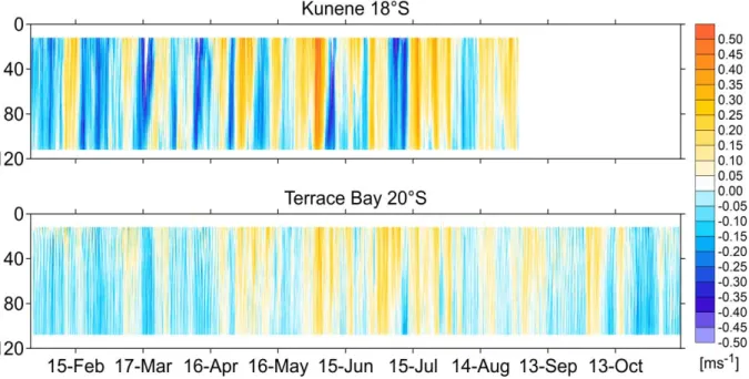
In the framework of the projects BMBF-SACUS and EU-PREFACE, we use bottom shields and moorings equipped current profilers on the Namibian shelf to observe the variability of the circulation, with a particular focus on the southward propagation of coastally trapped waves. These observatories were deployed and serviced in cooperation with our Namibian colleagues from National Marine Information and Research Center in Swakopmund in September 2014 and January 2015 using the Namibian Research Vessel MIRABILIS. The data sets of the instruments we recovered show elevated variability in the alongshore flow component having periods between one and two weeks superposed on weaker variability having longer time scales (Fig. 1). The shorter period variability can be interpreted in terms of coastal trapped waves that propagate southward along the coast. Between 18°S and 20°S a
Fig. 1: Time series of alongshore flow on the shelf at 18°N and 20°N from end of January to November 2015. Both time series we collected by acoustic Doppler current profilers mounted in bottom shields and deployed at 125m depth.
Dr. Marcus Dengler Meteor cruise M120
Fig. 2: Near-surface concentrations of methane (circles) measured during M120 and sea surface temperatures from satellite retrievals (contours).
weakening of their amplitudes can be observed (Fig. 1). This may be due to the Walvis Ridge that connects to the African coast just south of 18°S.
Trace gases in the surface waters
The chemists have continued their underway measurement program using their mobile equilibrator system. To date, they were able to record 25000 data points of trace gas concentrations measured every minute. Additionally, they performed 62 independent measurements of atmospheric trace gas concentra- tions. Most fascinating are the near- coastal concentration of the “big three” traces gases, namely carbon dioxide, methane and nitrous oxide (Fig. 2). On the shelf near Walvis Bay at 23°S, methane concentrations as high as 200 nmol/L were measured in the near surface waters.
These concentrations are two orders of magnitude larger than the equilibrium concentration of sea water with the atmosphere that are between 2 nmol/L and 3 nmol/L. In the ocean, methane is produced during the degradation process of organic material in anoxic conditions only. We observed these anoxic conditions in the near-bottom waters on the shelf. As methane is oxidized as soon as oxygen is present in the water column, fast vertical exchange processes are required to sustain the high concentrations in the ocean surface layer.
Imaging of fishes in the deep sea multi-beam echo sounder
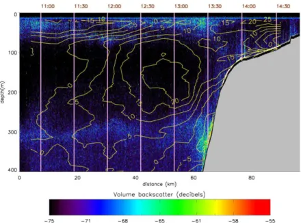
A major objective of the PREFACE project is to improve understanding of the effects of climate variability and change on fisheries in the eastern boundary upwelling regions of the tropical Atlantic. To investigate the impact of physical parameters such as currents and temperature on the habitat of fish, we analysed the water column backscatter of R/V METEOR’s deep sea multi-beam echo sounder. To date, standard data processing techniques for evaluating fish stock from this instrument have not been developed. Marek Ostrowski from the Institute of Marine Research in Bergen devoted a large part of his time on board processing and interpreting the water column data set. A particular interesting behaviour of mesopelagic fish stock was observed off Angola along 11°S (Fig. 3). There, shoals of fish were preferentially found in regions of low alongshore flow.
Dr. Marcus Dengler Meteor cruise M120
As predicted by our board meteorologist Carola Heitmann-Bacza from the German Weather Service, the southeast trade wind has significantly weakened in the last hours and we expect to carry out the postpone mooring and glider operations tomorrow. Additionally, we will complete the 23°S section within the remaining two day which completes our measurement program. We thank Captain Hammacher and his crew for the excellent collaboration and the pleasant atmosphere during the cruise.
Best regards from the tropical South Atlantic
Marcus Dengler and the participants of the M120 cruise
Fig. 3: Strength of volume backscatter signal of the deep water multi-beam echo sounder (EM122) in decibel (color). Elevated values indicate fish stock.
Superposed is the alongshore flow from the shipboard ADCP (in cm/s) collected simultaneously (yellow contours)