Realistic Modeling of Power Transmission Lines with
Geographic Information Systems
Joram Schito
ETH Zurich | Dissertation No. 26977 | 2020
Realistic Modeling of Power Transmission Lines with Geographic Information Systems
Joram Schito
Diss. ETH No. 26977
Realistic Modeling of Power Transmission Lines with Geographic Information Systems
A dissertation submitted to attain the degree of Doctor of Sciences of ETH Zurich
(Dr. sc. ETH Zurich)
presented by
Joram Benjamin Schito
Master of Science UZH in Geography born on 4 May 1984
citizen of Uster (Switzerland) and Sanarica (Italy)
accepted on the recommendation of Supervisor Prof. Dr. Martin Raubal
Institute of Cartography and Geoinformation Chair of Geoinformation Engineering ETH Zurich
1. Reviewer Prof. Dr. Adrienne Grêt-Regamey
Institute for Spatial and Landscape Development Chair of Planning of Landscape and Urban Systems ETH Zurich
2. Reviewer Prof. Dr. Piotr Jankowski Department of Geography San Diego State University
Joram Schito
Realistic Modeling of Power Transmission Lines with Geographic Information Systems, © 2020 DOI: 10.3929/ethz-b-000454195
ETH Zurich
Department of Civil, Environmental and Geomatic Engineering Institute of Cartography and Geoinformation
Chair of Geoinformation Engineering Stefano-Franscini-Platz 5
To Angelika, Marduk, and Inanna
and to my parents Irma and Luigi, who have done so much in return for so little.
Abstract
Since renewable energy sources are in increasing demand due to the energy transi- tion, the planning of new (Power) Transmission Line (TL) is becoming more and more important. Conflicting interests between stakeholders, the legislation and different transmission technologies turn TL planning into a complex spatial decision problem, however. Therefore, a Spatial Decision Support System (SDSS) which com- bines Multi-Criteria Decision Analysis (MCDA) techniques with methods provided by Geographic Information Systems (GIS) can support decision-makers in finding an optimal Transmission Line Path (TLP) that suits different interests. Existing SDSS, however, are constrained to either overhead lines or earth cables, while no computational solution has been found so far, for how they can be combined with each other. Furthermore, the methods prevailingly used come with some conceptual issues that affect realistic TL planning.
Therefore, we investigated several methods for making GIS-based TL planning more realistic, developing two approaches that are the first of their kind to identify an optimal corridor for a combined line (CL), based on two different decision models. Both approaches were included in a 3D Decision Support System (3D DSS), which consists of various algorithms for determining optimal TL corridors and paths on different voltage levels, regardless of the transmission technology.
A user study conducted with nine experts revealed that the procedural approach was most supported and represented stakeholders’ interests most reliably when identifying optimal CLs. Our results provide evidence that the 3D DSS facilitates the planning of new TLs, fosters the profound analysis of different alternatives, and supports stakeholders when discussing the benefits and weaknesses of different TLP alternatives. Since experts have high confidence in benefiting from a computer-based semi-automated approach, SDSS will play an increasingly important role in future TL planning.
Zusammenfassung
Die Energiewende und die steigende Nachfrage nach erneuerbarer Energie be- dingt, dass das bestehende Stromnetz modernisiert und ausgebaut werden muss.
Zu entscheiden, wo ein neues Leitungstrassee durchführen soll, ist keine einfache Aufgabe, da die Gesetzgebung berücksichtigt werden muss, verschiedene Interes- sensvertreter unterschiedliche Meinungen bezüglich des optimalen Leitungsverlaufs haben und die Frage, ob und wo Freileitungen oder Erdkabel verbaut werden sol- len, das Entscheidungsproblem zusätzlich erschwert. Aus diesem Grund kann ein Spatial Decision Support System (SDSS), das die Techniken der Multikriteriellen Entscheidungsanalyse (MCDA) mit den Methoden eines Geographischen Informati- onssystems (GIS) verbindet, Entscheidungsträger dabei unterstützen, das optimale Trassee für eine Hochspannungsleitung zu finden. Allerdings beschränken sich be- stehende Systeme auf eine Netztechnologie, da es bis anhin keinen Ansatz gab, optimale Freileitungs- und Erdkabelabschnitte mittels eines Algorithmus miteinan- der zu kombinieren. Bestehende Systeme wenden zudem Methoden an, die bei der Planung von Hochspannungsleitungen nicht in allen Belangen sinnvoll sind.
Aus diesem Grund haben wir mehrere Methoden erforscht, um die GIS-basierte Planung von Hochspannungsleitungen realistischer zu gestalten und stellen in dieser Dissertation zwei Ansätze vor, die erstmals eine optimale kombinierte Leitung – bestehend aus Freilitungs- und Erdkabelabschnitten – berechnen. Beide Ansätze wurden in das 3D Decision Support System (3D DSS) eingebettet, das mehrere Algorithmen enthält, um optimale Korridore und Leitungsverläufe auf unterschiedli- chen Netzebenen und ungeachtet der Übertragungstechnologie zu bestimmen. Eine durchgeführte Nutzerstudie mit neun Expertinnen und Experten zeigte, dass der prozedurale Ansatz den grössten Rückhalt erhielt und die Interessen der Interes- sensgruppen am zuverlässigsten modellierte. Unsere Resultate zeigen, dass das 3D DSS die Planung von Leitungen vereinfacht, eine vertiefte Analyse unterschiedlicher Alternativen ermöglicht und Interessensgruppen bei der sachlichen Diskussion über Vor- und Nachteile verschiedener Trassees unterstützt. Da Expertinnen und Experten darauf vertrauen, durch die Unterstützung eines SDSS breiter akzeptiertere Trassees zu finden, werden computergestützte Systeme in Zukunft eine wichtigere Rolle in der Leitungsplanung spielen.
Résumé
En raison de la transition énergétique et la demande croissante d’énergie renou- velable, le réseau électrique existant doit être modernisé et étendu. Décider sur le tracé d’une nouvelle ligne n’est pas facile, car la législation doit être prise en compte et il est possible que les parties prenantes aient des opinions différentes sur le tracé optimal. En outre, la question si et où des lignes aériennes ou des câbles souterrains doivent être installés, rend le problème de décision encore plus difficile.
Pour cette raison, un système d’aide à la décision sur des problèmes spatiaux (Spatial Decision Support System, SDSS), qui combine les techniques d’aide à la décision multicritères avec les méthodes d’un système d’information géographique (SIG), peut aider à trouver le tracé optimal d’une ligne à haute tension. Toutefois, les systèmes existants se limitent à une seule technologie de réseau, car actuellement, il n’y a pas eu d’approche permettant de combiner les sections optimales des lignes aériennes et des câbles souterrains avec l’aide d’un seul algorithme. En outre, les méthodes courantes proposé dans des études précédentes présentent parfois des irrégularités conceptionnelles dans la planification des lignes à haute tension.
Pour cette raison, nous avons étudié plusieurs méthodes pour rendre la planification des lignes à haute tension basée sur un SIG plus réaliste. De cette thèse de doctorat résultent deux nouvelles approches qui, pour la première fois, calculent une ligne combinée optimale composée des sections de lignes aériennes et des câbles souter- rains. Les deux approches ont été intégrées dans le 3D Decision Support System (3D DSS), un SDSS qui contient plusieurs algorithmes permettant de déterminer les couloirs et les tracés de lignes optimaux à différents niveaux de réseau et indépen- damment de la technologie de transmission. Une étude auprès de neuf experts a montré l’efficacité de l’approche procédurale puisqu’il a reçu le plus grand soutien et a modélisé les intérêts des parties prenantes de la manière la plus fiable. Nos résultats montrent que le 3D DSS simplifie la planification des lignes, permet une analyse approfondie des alternatives différentes et soutient les parties prenantes dans la discussion objective des avantages et des inconvénients des différents itiné- raires. Comme les experts sont convaincus qu’un SDSS soutient les décisionnaires à identifier un tracé plus largement accepté, les systèmes informatiques joueront un rôle plus important dans la planification des lignes à haute tension dans l’avenir.
Riassunto
La transizione energetica e la crescente domanda di energia rinnovabile compor- tano la necessità di modernizzare e ampliare la rete elettrica esistente. Tuttavia, il ritrovamento delle aree appropriate e la decisione dove costruire una nuova linea elettrica richiedono di tener conto della legislazione in vigore e delle eventuali opinioni diverse degli interessati sul tracciato ottimale della linea ad alta tensione.
Inoltre, la questione se e dove installare linee aeree o cavi interrati rende il pro- blema decisionale ancora più difficile. Per questo motivo, un sistema di supporto alle decisioni spaziali (SDSS, Spatial Decision Support System), che combina le tecniche dell’analisi decisionale a criteri multipli con i metodi dei sistemi informativi geografici (SIG), può aiutare i decisori a trovare il tracciato ottimale per una linea ad alta tensione. Tuttavia, i sistemi esistenti sono limitati ad una sola tecnologia di rete, poiché finora non è stato individuato un metodo di combinare le linee aeree e le sezioni di cavi interrati utilizzando un unico algoritmo. Inoltre, gli approcci predominanti proposti da studi recenti sono tuttavia caratterizzati da irregolarità concezionali che, se applicati sulle linee ad alta tensione, rischiano di influire la pianificazione del tracciato in maniera irrealistica.
Per questo motivo abbiamo preso in esame diversi metodi per rendere la pianificazio- ne delle linee ad alta tensione basata sui SIG più realistica. La presente tesi è inoltre incentrata sullo sviluppo di due approcci che, per la prima volta, calcolano una linea combinata ottimale che si costituisce da linee aeree e sezioni di cavi interrati.
Entrambi gli approcci sono stati incorporati nel 3D Decision Support System (3D DSS), che contiene diversi algoritmi per determinare corridoi e tracciati di linee ad alta tensione ottimali a diversi livelli di rete, nonché utilizzando ambe le tecnologie di trasmissione. Uno studio con nove esperti ha rivelato che l’approccio procedurale ha ricevuto il massimo sostegno, essendo adatto di modellare gli interessi dei gruppi interessati in modo più affidabile. I nostri risultati mostrano che il 3D DSS semplifica la pianificazione delle linee ad alta tensione, consente un’analisi approfondita delle diverse alternative e supporta gli interessati nella discussione obiettiva dei vantaggi e degli svantaggi dei diversi tracciati. Poiché gli esperti confidano nella capacità dei Spatial Decision Support System (SDSS) di sostenere i responsabili politici ed i pianificatori di trovare il tracciato più ampiamente accettato, i sistemi assistiti da computer svolgeranno un ruolo più importante nella pianificazione delle linee ad alta tensione in futuro.
Acknowledgements
„
Daddy, why are you always working so long?” –“Well, once I have completed my doctorate, I will get such a fancy hat [shows him a doctor’s hat on Google].” – “But why don’t you just buy one?”
—Dialogue between Joram and his son 2020
First, I would like to express my deepest appreciation to my advisor, Martin Raubal, for having given me the chance to fulfill one of my lifetime goals. I am very thankful that he gave me the freedom to deepen my knowledge in various aspects of GIScience and beyond, which helped me to improve the quality of my current and future work. I would like to extend my sincere thanks to the committee members, Adrienne Grêt-Regamey and Piotr Jankowski, for having provided me insights into their research relating to GIS-MCDA, which led me broaden my horizon concerning various aspects that needed to be investigated further. I would also like to extend my gratitude to my project partners of the research group Planning of Landscape and Urban Systems, Ulrike Wissen Hayek, Orencio Robaina Martinez de Salinas, and Ralph Sonderegger, for having brought their full experience, expertise, and creativity into the 3D DSS project. Many thanks also to Michael Moser and the SFOE for having supported the 3D DSS project and believed in its importance for the Swiss Energy Strategy 2050. Especially helpful to me during this time was the collaboration with Swissgrid, ewz, BKW, APG, and Elia—in particular Martin Weber, Joshu Jullier, Jonas Mühlethaler, Sandro Dinser, Julia Song-Zinggeler, Philippe Hans Meuli, Antonios Papaemmanouil, Patrick Lüscher, Remo Kälin, Marcel Stöckli, Marc Kostner, Christian Bellina, Britt Egger, and Johan Maricq—for their boundless support. I am also grateful to Ruth Kläy for administering the 3D DSS project and for our numerous, valuable discussions. I would further like to thank Judit Lienert for giving me insights into the methods used in MCDA.
Special thanks to all experts—in particular those affiliated with SFOE, FOEN, ARE, FOCP, and FKH, who accompanied the 3D DSS project and brought in their precious
knowledge, allowing me to understand the legal and technical background of trans- mission line planning in detail. Especially, I would like to thank all participants who took part in the numerous studies and workshops, making it possible to research methods for improving transmission line planning. I would further like to acknowl- edge the valuable contribution to the 3D DSS project of Julia Song-Zinggeler, Nadine Piveteau, Konstantinos Schoinas, and Daniele Moncecchi, who wrote their Master theses with full commitment.
I am extremely grateful for having worked together with my colleagues at the Institute of Cartography and Geoinformation, who contributed to a professional working environment in which I encountered unwavering support and share of ideas. In particular, I am deeply indebted to my long-time office mate, René Buffat, for introducing me into efficient programming and for answering all my questions.
Many thanks should also go to my friends, who have been a major source of support, for the wonderful times we shared. Finally, I would like to thank my family for their patience, that cannot be underestimated, and, in particular, to my wife who has always been there, thoughtful, motivating me, listening to me, laughing with me, loving me.
Contents
1 Introduction 1
1.1 Problem statement . . . 4
1.2 Research questions . . . 6
1.3 Contributions . . . 7
1.4 Dissertation Outline . . . 7
2 Literature review 9 2.1 How power transmission lines are planned . . . 9
2.1.1 Swiss approval process . . . 10
2.1.2 Legal and technical requirements . . . 13
2.1.3 Planning on different voltage levels . . . 18
2.1.4 Planning depending on transmission technologies . . . 19
2.2 Multi-Criteria Decision Analysis . . . 22
2.2.1 Modeling human behavior and decision processes . . . 23
2.2.2 The general MCDA process . . . 25
2.2.3 MADA methods . . . 26
2.2.4 MODA methods . . . 34
2.2.5 GIS-based MCDA . . . 37
2.3 Calculating an optimal transmission line path . . . 41
2.3.1 The concept of costs and cost surfaces . . . 41
2.3.2 Least Cost Path analysis . . . 43
2.4 Planning power transmission lines by combining MCDA with GIS . . 47
2.4.1 Overview of related studies . . . 47
2.4.2 Overview of similar research projects . . . 50
3 Materials and Methods 55 3.1 Issues with existing methods . . . 56
3.1.1 Conceptual issues . . . 56
3.1.2 Geometrical issues . . . 60
3.1.3 Limitations of the Least Cost Path analysis . . . 66
3.2 Study design . . . 70
3.2.1 Approach for answering the research questions . . . 70
3.2.2 Study areas and data . . . 72
3.2.3 Participants . . . 76
3.2.4 Procedure . . . 76
3.2.5 Hypotheses . . . 77
4 The 3D DSS 79 4.1 Background . . . 80
4.2 General description . . . 80
4.2.1 Functionalities . . . 81
4.2.2 Technical concept and involved parties . . . 82
4.3 Processing workflows . . . 84
4.3.1 Data preprocessing . . . 84
4.3.2 General workflow . . . 89
4.4 Methods for determining a combined line . . . 94
4.4.1 Procedural approach . . . 96
4.4.2 Probabilistic approach . . . 97
4.5 Decision model . . . 99
4.5.1 Criteria . . . 101
4.5.2 Objectives . . . 103
4.5.3 Resistances . . . 107
4.5.4 Value functions . . . 108
4.5.5 Weights . . . 110
4.5.6 MCDA methods . . . 112
4.5.7 Boundary models . . . 115
5 Results 121 5.1 Results for RQ1 . . . 121
5.1.1 Null hypotheses . . . 121
5.1.2 Descriptive statistics . . . 122
5.1.3 Inferential statistics . . . 124
5.1.4 Hypothesis testing . . . 126
5.1.5 Further results . . . 128
5.2 Results for RQ2 . . . 130
5.2.1 Operationalization of unclear terms . . . 130
5.2.2 Null hypotheses . . . 131
5.2.3 Qualitative analysis based on the expert interviews . . . 131
5.2.4 Descriptive statistics . . . 133
5.2.5 Inferential statistics . . . 135
5.2.6 Hypothesis testing . . . 138
5.2.7 Further results . . . 140
5.3 Summary of the key results . . . 142
6 Discussion 147 6.1 Discussion of the results regarding RQ1 . . . 147
6.1.1 Comparison with similar research projects . . . 148
6.1.2 Contribution . . . 148
6.2 Discussion of the results regarding RQ2 . . . 150
6.2.1 Comparison with similar research projects . . . 150
6.2.2 Contribution . . . 151
6.3 Limitations . . . 158
6.3.1 Accuracy . . . 158
6.3.2 Transparency . . . 163
6.4 Conclusion . . . 163
Bibliography 165 A Questionnaires 183 A.1 Questionnaire (preliminary study) . . . 183
A.2 Questionnaire (main study) . . . 188
List of Figures 201
List of Tables 203
List of Equations 205
Acronyms 207
Glossary 213
Legal Terms and Sources 223
Description of Used Geodata 227
Introduction 1
„
I strongly believe that GIS helps us solve many problems the world is facing at the moment. It would thus be helpful if GIS became more popular, such as by introducing it early in school, at each level, and no matter for which topic related to space.”—Answer at the teacher graduation exam, regarding the question, how GIS could be used in geography teaching 2013
It is the year 2020 and one can observe in a momentary snapshot the world and its inhabitants at a paramount point. While the amount of global trade is still increasing whereby not everyone can profit from that in terms of a higher wealth, a higher welfare, or even a secure home, many people do not recognize how many resources they actually consume. As the ecological footprint per capita is steadily increasing while rising CO2emissions foster the greenhouse effect and extreme weather phenomena, one might ask how the situation on our planet will be in the near future. In this regard, the United Nations Department of Economic and Social Affairs (2019) assumes a global population of9.7billion of people by 2050, of which 200 million refugees are expected to leave their home due to droughts, sea level rise, monsoons, or other consequences of climate change (Myers,2005).
India and Sub-Saharan Africa are expected to record the highest population increase in absolute numbers, but also a raising number of people at working age, which might lead in these countries to a higher GDP and (hopefully) also to more welfare (United Nations Department of Economic and Social Affairs, 2019). Under these conditions, one may ask, how the world of tomorrow will look like, assuming that more resources and thus, more energy will be consumed.
From 1973 to 2018, the world’s total consumption of energy increased from 4659 to 9717 Million tonnes of oil equivalent (Mtoe). Simultaneously, electricity, solar thermal and geothermal heat, and natural gas increased their shares of the world
(however, not in absolute numbers). Furthermore, all shares of fossil fuels but natural gas used to produce electricity decreased in favor of renewable energy sources. The amount of electricity produced by hydropower has increased while nuclear power has stagnated (International Energy Agency, 2019), the latter most probable as a consequence of the Fukushima effect. Especially in Europe, the meltdown in Fukushima led national energy agencies reconsider their strategy of producing nuclear power. The resulting strategies in Europe were mixed, as the governments of Belgium and Germany and the sovereign of Switzerland decided to phase out nuclear power, while the governments of Bulgaria and Romania planned to either extend the life cycle of existing plants or build new nuclear power plants (Aune et al., 2015). Nevertheless, the European Network of Transmission System Operators for Electricity (ENTSO-E) assumes that the total energy consumption based on finite fuels will decrease by 2030 (Chaniotis and Schmitt,2018). From that point of view, it can generally be stated that people consume more and more electricity while the fuels for producing it become more and more sustainable (International Energy Agency,2019).
The higher amount of electricity does not necessarily have to stress our planet and its resources unnecessarily, as long as the production of electricity and of the infrastructure plants producing and transporting it are sustainable, fair, and safe.
Electricity is further important, as too few electricity inhibits economic growth, while in turn, its availability does not necessarily guarantee economic growth (Ozturk, 2010). During the last years, electricity produced by renewable energy sources – as solar thermal and geothermal heat, photovoltaics, biomass, tidal power, and wind energy – became increasingly important for economy and accepted by societies, as it is “technically capable of providing the global population with sustainable heat, electricity and fuel in equitable and satisfactory lifestyles” (Twidell and Weir, 2015, p. 636). The role of nuclear fuels, though, is ambiguous: While nuclear fuels are risky and their waste is ecologically delicate to dispose for the next millennia, they are considered to foster the transition away from fossil fuels by producing almost CO2-neutral electricity. Despite the shifted trade-off margins between risks and benefits due to the Fukushima accident, nuclear fuels are still an important energy source in many countries’ energy portfolio (Srinivasan and Gopi Rethinaraj, 2013). Apart from the emissions generated for producing the power plants, the electricity generated from renewable energy sources is CO2-neutral (Abrell and Weigt, 2008). Compared with nuclear fuels, they are considered to be safer and more sustainable. However, the amount of electricity produced by renewable energy sources is difficult to forecast, as it depends on the geography, and on climate and weather conditions. Compared to fossil fuels, renewable energy sources emit less
greenhouse gases despite the amount of CO2needed for the production, operation, and removal of the power plants1. In regions where households use combustible fuels for cooking and heating, electricity from renewable energy sources (except wood) could prevent deforestation (Twidell and Weir,2015), foster gender equality, and support individuals and societies for increasing their welfare (Taylor,2017).
By contrast, renewable energy sources entail also some disadvantages (N. K. Roy and Das,2018). First, even though greenhouse gas emissions generated by wind farms are accordingly low, they cause many birds deaths, which cause environmental damage, as birds are crucial for many ecosystem cycles (Carrete et al.,2012). Second, the amount of electricity produced by renewable energy sources is more difficult or uncertain to predict, as it can happen that too much or too little electricity is produced and transmitted through the grid. In both cases, ancillary services (Hodge et al., 2013; Brandão et al.,2013) must be activated in order to keep the power frequency or the voltage constant. Thus, many recent research projects investigated, to what extent excessive electricity could be stored adiabatically in caverns filled with gravel-like materials (Geissbühler et al.,2018; Luo et al.,2016), Power-to-Gas systems (Bailera et al.,2017; Götz et al.,2016), batteries or novel nanomaterials (Gogotsi and Penner,2018), or even in electric vehicles (Buffat et al.,2018; Alhelou and Golshan,2016) and to retrieve it when needed. On the other hand, the transition towards renewable energy sources transmits more electricity through the grid, which in addition is unequally distributed and less predictable over time. Thus, these circumstances require extending and modernizing the existing grid in order to meet the technical needs for the next decades.
However, the planning of new power transmission lines takes a long time, as many details must be clarified together with different stakeholders. Grid extension projects are often delayed due to a lack of public acceptance (Jullier, 2016). This lack of acceptance is deeply rooted, as overhead lines decrease the price for building land (Cain and Nelson,2013), disrupt the perception of the apparently immaculate land-
scape, cause noise due to the corona effect, and are often perceived as dangerous to health due to the induced electromagnetic field (Hedtke et al.,2018). Several studies revealed that citizens tend to object grid extension projects as soon as they are directly affected by them, which is also denoted as the NIMBY effect (Devine- Wright, 2012). Furthermore, (Power) Transmission Line (TL) planners have to
1. Surely, the CO2emissions depend on the fuel used for producing the electricity that is used for manufacturing the according energy system. Based on a current fuel mix needed to produce this amount of electricity, Alsema (2012) calculated that photovoltaic systems generate on average 0.57 kg CO2emissions per Kilowatt hour (kWh) of produced energy over the whole life cycle. This is much higher than biomass (approx. 0.2 kg CO2per kWh) or wind (approx. 0.09 kg CO2per kWh) and thus, charges the atmosphere analogically, considering that CO2remains in the atmosphere for
meet legal requirements and face planning issues of rising complexity, as the urban space is inhabited more and more densely. Vested interest of different stakeholders complicate the decision-making even more, even when the legal conditions are followed by all the stakeholders involved in the decision-making process (Kiessling et al., 2003a). Last, as many citizens expect that new TLs should be built under- ground as Earth Cables (ECs) instead of Overhead Lines (OLs), the social pressure towards non-obtrusive technologies increased significantly (Lienert, Suetterlin, et al., 2015).
Methods from Geographic Information Science (GIScience) could support TL plan- ners in finding a Transmission Line Corridor (TLC) that meets the interests of all stakeholders as far as possible. Such an approach requires, on the one hand, that the problem can be solved by using spatial methods, and, on the other hand, that the problem can be formalized and expressed in terms of formulas while using spatial attributes or objectives (Malczewski and Rinner,2015). On this basis, a computer program built on the thinking of rational decision-making and accompanied by communication and negotiation processes could determine a location-based good- ness (or aversion) for (or against) building a TL based on given data sets while considering legal requirements and being as objective as possible. Such a framework, correctly defined as Decision Support System (DSS) and, while regarding the spatial characteristics, even more precisely entitled as Spatial Decision Support System (SDSS), might support planners as well as decision-makers in offering corridor or path alternatives based on stakeholder preferences. In this regard, a semi-automated approach could further reduce costs and save time, allowing the involved stakehold- ers to invest their time in the discussions aiming at finding a feasible alternative instead of generating them.
1.1 Problem statement
The basic approaches aiming at facilitating TL planning by the support of Geographic Information Systems (GIS) have been researched and improved since the 1970’s.
Apart from some new trends regarding network optimization, the main procedure basically remained unchanged, as it combines two powerful methods for determining an optimal TLC or Transmission Line Path (TLP) while considering at least one set of interests: On the one hand, Multi-Criteria Decision Analysis (MCDA) is used to consider different opinions regarding attributes or objectives. While being a method mainly used in Operations Research (Belton and T. Stewart,2002; Eisenführ et al., 2010), it can be applied to spatial problems, e.g., to compute land feasibility maps
(Ligmann-Zielinska and Jankowski,2014) or to rank different alternatives in a path network (Malczewski and Rinner,2015). Even though MCDA encompasses a large collection of mathematical methods, the preferred GIS-based method used in TL planning has been to apply a Weighted Linear Combination (WLC) on a set of layers that contain spatial data and to derive a cost surface. On the other hand, Least Cost Path (LCP) analysis can be applied on such a cost surface to determine the path with least costs, which in an ideal case would represent the optimal TL path from the start to the end point. Theoretically, the combination of both approaches would be fair and yield objective results, as MCDA considers different opinions regarding the components that should be taken into consideration when deciding between different path alternatives, and because the LCP represents a mathematically optimal solution.
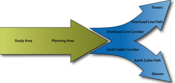
However, a recent study revealed that stakeholders are relatively sceptical towards computer-generated corridor or path alternatives and that the solutions proposed by an SDSS were seen to be too mathematical and in turn, less realistic than paths that were drawn by hand (Schito, Jullier, et al.,2019). Additionally, while existing methods based on the funnel approach (Houston and Johnson,2006) can indeed determine corridors or paths of a single transmission technology, GIScience does not offer yet a sophisticated method that allows to plan a TL that comprises a combination of OL and EC segments. This dilemma is represented in Fig. 1.1 as diverging blue branches as planners must decide in advance whether a GIS-supported procedure should model either an OL or an EC. Furthermore, a decision model does not necessarily have to be applicable to different study regions or to different voltage levels, as the planning of TLs differs among urban and rural areas.
In this regard, the current dissertation seizes these issues, as it investigates, to what extent a modeling approach for a 150 Kilovolt (kV) EC in relatively small but dense urban areas can be used for modeling parts of a 380 kV overhead or combined TL in wider, rural and urban areas. Moreover, the current dissertation compares two approaches that generate a combined TL which consists of OL and EC segments and complies with the according planning rules. More precisely, a classical approach used in MCDA will be compared with a novel procedural method described conceptually by Schito and Raubal (2018). While the classical method carries out a sensitivity analysis on different weighting proportions between OL and EC to obtain a combined corridor, the procedural approach searches for areas that are in higher need of EC segments than others and computes the connecting OLs after the EC segments have been set. While the former approach has often been discussed in practice, the latter approach rather pursues the legal conditions given in the Sectoral Plan for Transmission Lines (SÜL) (DETEC, 2001). Thus, it is of
Fig. 1.1.: The basic procedure for planning TLs narrows down the area of interest step by step. However, the applied method only allows to determine either OLs or ECs, which are shown as separate blue branches.
scientific importance to evaluate, whether a rather conventional or a novel approach might improve TL modeling in terms of realizability.
This dissertation further aims at examining the achieved results in terms of the degree of realism. In this regard, we consider a result to be ‘realistic’ if the planning experts assessed the result a high chance to be a) accepted due to legal regulations and b) accepted as a feasible solution. More precisely, we defined a solution to be ‘feasible’ if the experts assessed it as a reasoned, well-grounded solution that considered all relevant factors for making a decision conceivably in its favor.
1.2 Research questions
The aim of this dissertation is to address the deficiencies identified in the previous section and to propose methods that make semi-automated TL planning more realistic. The following two research questions are ordered by the priority of the processes that must be included in a SDSS to answer the research questions (RQ).
RQ1 Which advantages or disadvantages does a procedural approach for computing combined TLs have compared to a probabilistic approach that applies different weights on two decision models for obtaining the optimal combined TLPs?
RQ2 In which areas and to what extent does a semi-automated SDSS including
1.3 Contributions
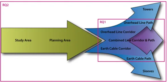
As an integral part of realistic TL planning, the current dissertation extends the basic procedure shown in Fig. 1.1 by suggesting a procedural approach for computing combined lines (CLs) by comparing it to a conventional probabilistic approach provided by MCDA (see RQ1 in Fig. 1.2). This dissertation further aims at suggesting methods particularly useful for fostering the partial automation of GIS-based TL planning and thus, for simplifying and shortening the planning procedure (see RQ2 in Fig. 1.2). In this regard, this dissertation further evaluates a broad set of extended methods that use common approaches used in GIScience for obtaining realistic results for high-voltage and extra-high-voltage TLs. This is of high importance, as the main principles used in this field, WLC and LCP analysis, are often too general for solving specific problems concerning route finding of either OLs or ECs.
Fig. 1.2.: Extended procedure for planning power transmission lines that narrows down the area of interest step by step and includes a uniting arrow that combines the overhead with the underground branch. The purple boxes represent the parts of the process in which the research questions (RQ) are positioned.
1.4 Dissertation Outline
This dissertation will first summarize the literature relevant to understand the topic of TL planning by means of GIS, mainly including related projects that also use MCDA as a basis for objective decision-making. The literature review will also describe the legal planning procedure of our study areas, which are both located in Switzerland.
GIS-based methods for planning TLs and explain the procedure used for answering the RQ. As a substantial part of this dissertation, we will describe the working mechanism of the 3D Decision Support System (3D DSS) in a separate chapter and focus hereby on the novel approach. The results chapter will then include the statistical results of the study for answering the research questions, followed by a discussion that interprets the results with regard to the related literature. Finally, the conclusion puts the results in the initial context, whether the developed approaches are able to provide results that are sufficiently realistic for being feasible in practice, and if not, which possible steps future research could undertake in order to do so.
We urge the reader of this dissertation to take note that all abbreviations can be looked up in the acronyms glossary (see Acronyms). Key terms are explained in the main glossary (see Glossary). As laws are of special importance in this dissertation, they are noted according to the official style guide (Swiss Federal Chancellery,2019) and explained and referenced in detail in the laws glossary (see Legal Terms and Sources). Finally, all data sets used in our decision model are detailed in the geodata glossary (see Description of Used Geodata).
Literature review 2
„
Based on an empirical study, we found out that neither the utility function A nor B had a significant impact on the results, but this curve here, C, had an impact, because...” [2 seconds pause while he is thinking, whether he really wants to expand on that in more detail] “...it is simply the case.”—Excerpt of a speech at a conference, followed by applause
2018
2.1 How power transmission lines are planned
TL planning has lasting consequences on the landscape, as TLs are designed for a lifetime of approximately 50 years or more (Kiessling et al.,2003a). The subsequent urban sprawl can exacerbate the landscape fragmentation even more, since other linear infrastructural components, such as roads, highways, or railways, are likely to be planned beside a TL or vice versa. This urban sprawl does not only disrupt the integrity of the landscape, but also impede animals’ natural movements (Czamanski et al.,2008). Even though TLs are important for the welfare of a society, the so-called NIMBY effect leads citizens to oppose a new TL if their own sphere of interest is affected (Devine-Wright,2011). Even though in most cases the government decides about the TL route, citizens or Non-Governmental Organizations (NGOs) can use their constitutional right to dispute it by taking legal action, albeit with unclear ending and provided that the legislation is sufficiently anchored in democracy. Since the jurisprudence in a constitutional country is on a balancing of interests, another possibility is to let the stakeholders from various interest groups participate in an early phase of the planning process (Rendigs,2016; Bertsch and Fichtner,2016). In this way, decision-makers—ideally supported by an analyst and a SDSS—could try to find a solution that considers the ambiguous interests of different stakeholders in
the best possible manner. Section 2.2.2 will show how MCDA helps identifying such solutions.
As this dissertation focuses on a study area in central Switzerland, the following subsections detail the Swiss TL approval process. Special attention will be paid to those early stages, in which a TLC feasible for constructing a TL is identified. Thus, the subsequent sections explain the legislation, the conceptual planning rules, and the technical requirements in more detail. We will further distinguish them between two transmission technologies (OLs and ECs) and two voltage levels (high-voltage and extra-high-voltage). The literature review summarizes the most important as- pects for the definition of a GIS-based decision model for TLs in Switzerland. Finally, we use the English abbreviations for the corresponding sources of the law where officially provided while otherwise retaining the official German abbreviation.
2.1.1 Swiss approval process
The legislation including the structure of how the regulatory control for new TLs is organized, varies from country to country (Kiessling et al.,2003a). In Switzerland, the approval process is based on the Swiss Energy Strategy 2050, and thus, on the Federal Act on the Conversion and Expansion of the Electricity Grid. This act defines the legal framework conditions for accelerating the approval process for TLs and increasing public acceptance. This is necessary to fulfill the objectives of the Swiss Energy Strategy 2050 and to ensure the timely extension and modernization of the necessary electricity grids.
The stakeholders involved in the approval process
One part of the Swiss Energy Strategy 2050 determines the approval process for new TLs. In this process, four stakeholders, with different roles, are involved:
1. The Swiss national transmission system operator (Swissgrid) which is re- sponsible for grid operation. Moreover, Swissgrid is the project owner of all extra-high-voltage TL planning projects and also responsible for writing a proposal containing a number of corridor alternatives.
2. The Swiss Federal Office of Energy (SFOE) is responsible for reviewing pro- posals submitted by Swissgrid in cooperation with other national authorities, such as the Federal Office for the Environment (FOEN) or the Federal Office for Spatial Development (ARE). The SFOE refines the proposal and draws a
The plan further provides information about the transmission technology used in the different sections of the TL.
3. The Federal Inspectorate for Heavy Current Installations (ESTI) is responsible for approving the plan submitted by the SFOE.
4. Directly affected citizens, municipalities, and cantons, as well as NGOs have the constitutional right to object to the specified TL route.
The approval process in detail
This approval process consists of four phases: 1) determination of needs; 2) sectoral planning process (SPV); 3) planning the construction project; and 4) planning approval procedure (PGV) (Jullier,2016), which are explained in more detail:
1. During the first phase, Swissgrid defines the projects necessary for modernizing and extending the extra-high-voltage grid for the next ten years. These projects are specified in the strategic grid plan and must be confirmed by the Federal Electricity Commission.
2. During the second phase, the SPV, Swissgrid first determines the planning area options, and then specifies a varying number of potential TLCs including the transmission technology to be used in the planning area. The intended planning area and TLCs are discussed with, and evaluated by, a support group, defined by the SFOE. This support group assesses the different TLC alternatives based on the ‘Assessment Scheme for Transmission Lines’ (SFOE,2013a) and by following the explanation defined in the corresponding manual (SFOE, 2013b). It consists of representatives of various national authorities and of the cantons affected by the project, at least one national environmental protection organization, and Swissgrid. Once the support group has recommended one TLC containing one feasible, but not legally binding TLP, this proposal will be submitted to the SFOE for reviewing and publication, which starts the public consultation (→Ordinance on the Planning Approval Procedure for Electrical Systems (VPeA)). The public consultation allows directly-affected citizens to be involved in this process. The SFOE further refines the proposal through an official consultation among the public and federal offices. The final proposal is then submitted to the Federal Council for ratification. This terminates the SPV and yields a legally binding TLC which will be registered in the SÜL with information about the used transmission technology.
3. The third phase initiates the PGV, a legal procedure in which a delegation of
the defined TLC. Swissgrid sets up a project advisory council, involving repre- sentatives from affected municipalities, regional environmental organizations, related interest associations, and directly-affected landowners. Then, Swiss- grid defines the final routing of the line by considering their recommendations and submits the detailed construction proposal to the ESTI for review (Jullier, 2016). Once the ESTI accepted the proposal, it publishes the building appli- cation, which in turn initiates the appeal procedure (→Ordinance on Spatial Planning (RPV)).
4. During the final phase, municipalities and directly-affected citizens have the constitutional right to object to the proposed routing (→VPeA) because the PGV underlies a legal procedure. If no other option could be found and if public interest predominates private interest, the approving authority could also request expropriate affected landowners. If, after negotiations, the objectors still do not agree with the changes in the SÜL, they can appeal against it all the way up to the Swiss Federal Supreme Court (Jullier,2016). The project must be refined in case of any judgement in favor of the objectors. Otherwise, the PGV terminates once the SFOE accepts the building application, which allows to construct the TL according to plan. If landowners were to be expropriated, they are compensated according to the Federal Act on High- and Low-Voltage Systems (EleG).
Legal interrelationship
From a legal perspective, the competences of each institution with regards to electric- ity transmission are defined in the Federal Act on the Electricity Supply (StromVG).
The SPV and the PGV are regulated by the EleG and by the VPeA. Both processes affect the authoritative plans used for urban planning on federal, cantonal, and municipal levels. Extending the extra-high-voltage grid requires modifying the SÜL by applying the SPV (DETEC, 2001). Any changes regarding official (urban plan- ning) plans are subject to the Spatial Planning Act (SPA) and to the corresponding RPV. The principles defined in these acts aim to integrate various factors into the evaluation about the optimal location for new TLs, as for example, the environment, the landscape, the human living space, and agriculture, which requires to consider the corresponding acts and regulations as well as the overarching Swiss Federal Constitution (BV). For this reason, TL planning must comply with all relevant laws and regulations and from these, deduce rules that legally justify a determined TL route.
2.1.2 Legal and technical requirements for power transmission lines
Resources and strategies used by planners
As mentioned in Section 2.1.1, planning TLs requires considering many different regulations and standards. In addition to the legal and technical prerequisites also the whole planning process (W. Li,2011) is often so complex that obtaining a ‘route of least objection’ cannot always be guaranteed (Stephen, 2017, p. 33). Many authors described the technical planning of TLs while also considering economic aspects (Haubrich et al.,2001; Stephen, 2017; Kasikci, 2001; Sallam and Malik, 2018), whereas others built probabilistic models (W. Li,2011) or applied linear programming on network graphs (Seifi and Sepasian,2011) to determine the optimal route for new TLs. Even though the mentioned planning approaches have been widely applied during the detailed planning phase, existing literature often lacks on describing approaches that consider additional factors as urban planning, social interests, environment protection, or protection of cultural property in an early planning phase.
By contrast, Kiessling et al. (2003a) described a more holistic approach by including various environmental and social factors that affect TL planning and should be considered by planners when evaluating whether an area is feasible for constructing a TL. For the particular case of Swiss urban planning, Rendigs (2016) evaluated all factors and standards important for TL planning as well as the legally applied planning processes, SPV and PGV, in detail. On behalf of Swissgrid, Kleiner et al.
(2016) developed a process standard guideline that describes how planners can sequentially identify the planning area, a feasible TLC, and a TLP alternative by means of GIS and by taking factors related to the landscape and the environment into consideration. For this, they applied a method that sequentially narrowed down the area of interest by iterative analysis steps in which the decision model was increasingly restricted (→funnel approach) while using a similar GIS processing chain as described by (Houston and Johnson, 2006). Kleiner et al. (2015) also summarized all legal factors that affect TL planning in the same study area as one of those used in the scope of this dissertation.
The role of GIS and available data for the planning process
Despite preliminary work, the basic instrument used for assessing the environmental feasibility of an area for building TLs is often limited to the environmental impact assessment (Kiessling et al.,2003a). The assessment form used by the support group
during the Swiss approval process (→assessment scheme for transmission lines, Section 2.1.1) considers an even broader range of aspects, as it covers technical re- quirements, economic efficiency, environmental protection, and spatial development (SFOE,2013b). However, some technical and economic criteria that must be as- sessed in this form cannot be calculated by GIS. This shortcoming raises the question of role played by GIS-based models and methods in the TL planning process. On the one hand, 3D visualizations can be used to support the stakeholders’ imagination about a specific TL project or to support discussions so that they are conducted objectively rather than emotionally (Rendigs,2016). However, even though methods related to GIS or MCDA have a high potential to support discussions (Schito, Jullier, et al.,2019), their use is neither compulsory nor prescribed by law.
Furthermore, available data sets are sometimes not directly applicable to the regula- tions. For example, the Inventory of Nationally Protected Landscapes (BLN) consists of many areas that fulfill specific protection objectives that are defined for each region individually. Therefore, a specific area is considered more or less worthy of being protected, which depends on the degree to which the protection objectives can be applied to this specific area. However, the BLN data set does not distinguish between the worthiness of being protected, but specifies just one single area, which in the case of the current dissertation is referred to the BLN inventory number 1608 ‘Flysch landscape Hagerle – Glaubenberg – Schlieren’. Another paramount shortcoming that would facilitate planning is the lack of a data set that distinguishes buildings between being classified as locations with sensitive usage (OMEN) or as locations for short-term stay (OKA). However, as an OMEN is defined as a location or a room but not as a whole building, it must be decided for each location within the building itself if it complies with the standards of being declared as an OMEN or not, which makes it almost impossible to create such a data set. Since such crucial information is either missing or subject to subjective assessment, it is not yet possible to define a decision model for a GIS that complies with all legal requirements.
Limits provided by different ordinances
However, GIS can support planners in distinguishing feasible from non-feasible areas if precise distances or values are provided. In this regard, planners must consider the following minimum distances based on the corresponding legal regulation:
— Immission limit of100µT based on the Ordinance on Protection against Non- Ionizing Radiation (ONIR), which corresponds to approximately8to12m for a OL and3to5m for a EC (see Fig. 2.1)
— Installation limit of1µT based on the ONIR, which corresponds to approxi- mately60to80m for a OL and6to8m for a EC (see Fig. 2.1)
— Noise pullution limit of40dB(A) during the night and50dB(A) during the day for recreation areas based on Noise Abatement Ordinance (NAO)
— Noise pullution limit of45dB(A) during the night and55dB(A) during the day for residential areas based on NAO
— Noise pullution limit of50dB(A) during the night and60dB(A) during the day for mixed areas based on NAO
— Noise pullution limit of55dB(A) during the night and65dB(A) during the day for industrial areas based on NAO
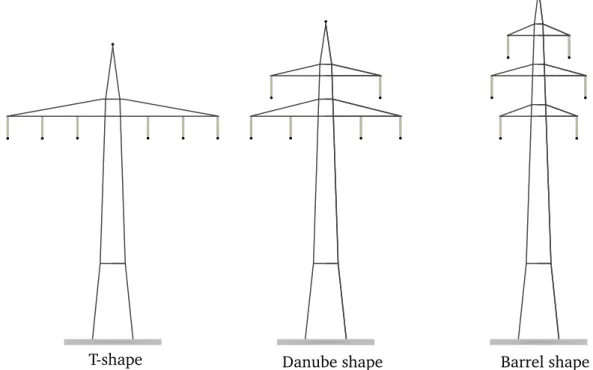
As the current determines the extension of the magnetic field, the immission and installation limits correspond to the maximum extension under full load of2240A which can be transported by a voltage of 380kV (Baumann and Joss, 2007). Re- garding the noise pollution, a study conducted at the Swiss Federal Laboratories for Materials Science and Technology (Empa) revealed that the corona effect emitted by a OL reaches the critical value of 45dB(A) at a distance of58m, assuming a moderate aging, a ‘Barrel’-shaped electricity pylon (see Fig. 2.2 right panel), an average precipitation of 1mm/h, and electricity flowing with a voltage of380kV (Heutschi and Eggenschwiler,2010). We verified the mentioned distance by using the software ‘HVLNoise 1.0’, which was also developed at Empa, and determined a critical distance of97m if a ‘Danube’-shaped electricity pylon (see Fig. 2.2 center panel) was used under the same conditions. As noises due to the corona effect could be reduced by various methods, such as adapting the shape of the pylons, coating the conductors with a hydrophile material (U. Straumann,2007), or selecting a conductor based on a low-noise shape or wiring (Kiessling et al.,2003c), measures for reducing the noise can be taken in a late planning phase while the immission and installation limit cannot. Thus, it becomes clear that the critical distance for a noise level of45dB(A) can be limited to a distance lower than the installation limit.
The importance of the hierarchy of laws for transmission line planning
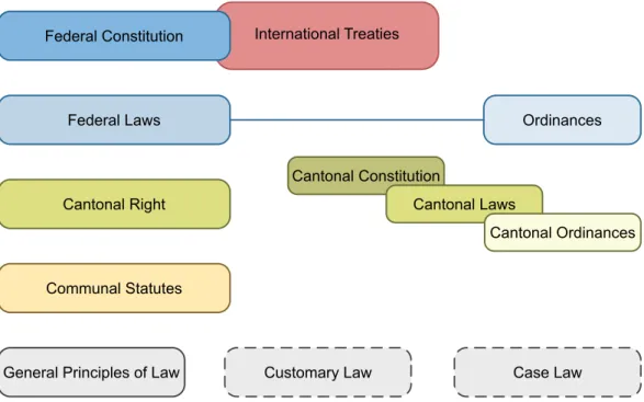
The hierarchy of laws defines how the sources of the law are organized within the state apparatus (Clegg et al.,2016). Fig. 2.3 shows the hierarchy of laws for the Swiss legislation. Federal, cantonal, or communal legal sources are shown in blue, green, and yellow, each of decreasing importance the brighter the color. The Federal constitution implies international treaties and acts as fundamental order for cohabitation and defines the basic state structure. Federal laws are legal norms
Fig. 2.1.: Immission limits (orange areas) and installation limits (blue circles) for an OL (left) and for an EC (right). ©Swiss Research Foundation for Electricity and Mobile Communication (FSM) (2019).
that went through a legislative procedure while ordinances are subordinated, clearly specified legal norms enacted by the government without going through a legislative procedure. In general, cantonal right is subordinate to federal right and communal right is subordinate to cantonal right. Jurisprudence is mainly based on general principles of law, however, by considering customary law and case law (Mosimann and Winsky,2012).
T-shape Danube shape Barrel shape
Fig. 2.2.: Three widespread pylon types.
In this regard, TL planning must especially consider all laws that might be affected by the construction of a TL. Besides the formerly explained aspects of urban planning, irradiation, or noise pollution, protecting the environment and the typical Swiss
mire landscapes is defined in the BV, the regulations for building any installations in the corresponding areas are very strict. The protection of mire landscapes is defined in the Ordinance on Mire Landscape Protection while the Ordinance on Fen Protection regulates the protection of fens and mires in more detail. While both the Federal Act on the Protection of the Environment (EPA) and the Federal Act on the Protection of Nature and Cultural Heritage (NCHA) aim to protect the natural environment, the EPA emphasizes rather the protection from environmental impacts that could harm all livings, their habitats and the biodiversity. By contrast, the NCHA concerns the protection from long-term impacts caused due to human influence and urban planning, as it further encompasses the protection of beautiful landscapes as well as cultural heritages.
The hierarchy of laws reflects how important it is for planners to consider the corresponding laws. As this was of great importance during our studies, we explain in Section 4.5.3 in detail how we integrated this information into our data and decision model.
Federal Laws
International Treaties
Ordinances
Cantonal Right
Cantonal Constitution
Cantonal Laws
Cantonal Ordinances
Communal Statutes
General Principles of Law Customary Law Case Law
Federal Constitution
Fig. 2.3.: The hierarchical structure of the sources of the law in Switzerland (based on Mosimann and Winsky (2012)).
2.1.3 Transmission line planning on different voltage levels
Situation for the transmission grid
As explained in Section 2.1.1 and Section 2.1.2, the VPeA regulates the procedure how extra-high-voltage TLs (see grid level 1 in Fig. 2.4) are approved. This is prescribed by law because extra-high-voltage TLs are of national interest according to Art. 15d EleG, which in turn effects a binding change in the SÜL. Therefore, TL projects on the highest voltage level necessitate a legally binding planning procedure (which is binding for authorities) according to Art. 2 SPA. The transmission grid is planned and operated by a Transmission System Operator (TSO), which in the case of Switzerland is Swissgrid. Since Swissgrid assumes authoritative duties when planning extra-high-voltage TLs, it can make use of the SPV as a planning instrument for obtaining a binding TLC, provided that the planning was thorough and that the balancing of interests has been considered. This facilitates the subsequent PGV, as the TLC, in which the proposed TLP must be located, is legally binding.
Situation for the distribution grid
However, high-voltage, medium-voltage, and low-voltage TLs, whose compound is defined as distribution grid (see grid levels 3 to 7 in Fig. 2.4), must be approved by cantonal authorities because they are not of national interest according to the SPA. Art. 5 and 8 StromVG state that the cantons define which area is assigned to an electricity company, which is called Distribution System Operator (DSO), for operating and maintaining the distribution grid. Since the DSOs are not regarded to be national authorities and due to the fact that the distribution grid is not of national interest, DSOs cannot make use of the SPV for obtaining a binding TLC.
This is important because any TL construction project is only subject to the legal procedure of the PGV, which can be objected by directly-affected citizens.
The missing possibility for the DSOs for using the SPV is one important reason that DSOs make use of Art. 3a StromVG, which states that the cantons and municipalities can grant concessions to electricity companies for using “the public ground and land”
for building TLs. These concessions may simplify determining an optimal TLC since, on the one hand, the feasible area becomes restricted, and, on the other hand, public places are more difficult to be objected by citizens. Nonetheless DSOs must conduct, similar to the SPV, an environmental impact assessment and a thorough balancing of interests before submitting a building application for extending the distribution grid (Klaus,2020).
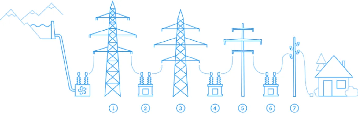
Fig. 2.4.: The grid levels. 1: extra-high-voltage, 3: high-voltage, 5: medium-voltage, 7:
low-voltage. The even numbers represent transformer levels that transform the current to the inferior level (reverse is also possible, but rare). ©Swissgrid.
2.1.4 Transmission line planning depending on transmission technologies
The statements of Section 2.1.3 are the basis to understand why more and more cables are laid underground the lower the grid level (see Fig. 2.4) becomes. Again, we must distinguish extra-high-voltage TLs from the other TLs because of their different legal basis and history.
A judgement with consequences
On the extra-high-voltage grid level, Art. 15b EleG does not prescribe a transmission technology that should be used, as it states that the TL can be constructed as an OL or as an EC. Each cabling alternative must be evaluated individually by using the assessment scheme for transmission lines (see Section 2.1.1). However, the Judgement 1C_398/2010 from 5 April 2011 was decisive for forcing the planning authorities to discuss during the SPV at least one alternative in which a partial EC is proposed. In the case of Riniken, the Federal court deemed the balancing of interests to be insufficient. In this regard, the judgement was important also for the public discussion, to what extent additional monetary costs for an EC compared to the costs of an OL can be accepted for protecting the landscape and the environment. These discussions led to substantial changes in the EleG (AS 2019), which allowed the planning authority to propose compensation measures regarding environmental and landscape protection (Art. 11a EleG, AS 2019) and to define, for the distribution grid, a scope of additional costs for building an EC instead of an OL that must be accepted by approving authorities (Art. 11b–e EleG, AS 2019) (Song-Zinggeler, 2020; Klaus,2020).
Advantages and disadvantages of overhead lines and earth cables
Furthermore, the judgement balanced general advantages and disadvantages of both transmission technologies to obtain the net efficiency of both technologies.
We extended this list by the findings we obtained while talking with several ex- perts in this field (Weber, 2015; Bräunlich, 2017; Dinser, 2017; Stöckli, 2020;
Dürrenberger,2020) and by other literature (Kiessling et al.,2003a; Kiessling et al., 2003c; Menges and Beyer, 2016; Swiss Research Foundation for Electricity and Mobile Communication (FSM),2019) and obtained the following advantages and disadvantages:
Tab. 2.1.: Advantages and disadvantages of building an OL compared to an EC.
Advantages Disadvantages
OLs have a better overall life cycle assess- ment than ECs. One reason for this is that ECs must be replaced after approximately 40 years whereas OLs have an estimated life cycle of 70 years.
Nowadays, OLs have a lower transmission capacity, thus, more electric losses, than ECs since it decreases during the years due to aging processes.
OLs require less construction costs than ECs.
OLs are less accepted in the society than ECs.
OLs have a smaller impact on the environ- ment during construction than ECs.
OLs have a higher impact on the landscape than ECs.
If a TL should cross a forest, an OL could span it by installing tall TTs.
Tall TTs would be visible and affect the aes- thetics of the landscape. However, laying an EC in a forest would also be visible as an aisle as it requires to plant trees with low-growing roots.
The risk of impairing the groundwater flow is lower when installing TTs instead of an EC since the EC is continuous and requires approximately3to5m of depth.
Given the same current, the magnetic field of OLs is larger than those of ECs.
Restrictions regarding the building ap- proval are smaller when planning OLs since a finite number of TTs must be spotted that could also be shifted. By contrast, ECs are continuous, which impedes crossing areas with a ban of constructing any infrastruc- ture or that are technically difficult or im- possible to cross underground.
Planning OLs is less complex than planning ECs because ECs require to consider more criteria and to invest more effort in the (spatiotemporal) construction planning.
OLs need less idle power than ECs.
Why are more cables laid underground with decreasing grid level?
For the distribution grid, the Art. 11b–e EleG (AS 2019) mentioned above aims at simplifying the decision about the transmission technology to be used. Thus, an EC is preferred over an OL if the approving authority (which in the case of the distribution grid is the corresponding canton) accepts costs for an EC being not more than twice as much as for an OL. Furthermore, it became more and more a standard to lay the ECs of the medium-voltage and of the high-voltage grid underground in urban areas because of decreasing production and installation costs (Klaus,2020).
As mentioned in Section 2.1.3, Art. 3a StromVG allows cantonal and municipal authorities to award a DSO the concession of using “the public ground and land.”
Therefore, a strategy often applied is to lay an EC under public places, such as streets or squares—provided that the TL complies with the regulations of the ONIR and of the Ordinance on Electrical Lines (LeV). In this way, the probability of causing lasting legal proceedings and objections can be reduced.
Choosing an appropriate construction method for earth cables
A further aspect that must be considered is the impact of the construction site on the environment and on affected citizens. Despite being the cheapest construction method for ECs, construction sites that use an open trench for laying the cables require more space and may impede the traffic more and over a longer period of time than by using a flush drilling. Non-invasive methods, such as flush drilling, in-hole drilling, ramming, bursting, or moling, allow further to pass under existing streets and pipelines without needing to dig a trench and thus, blocking a road. However, an open trench allows the construction workers to foresee potential problems and to act accordingly if the used construction plans are inaccurate or do not list existing infrastructure (Bütikofer,2017). Laying cables requires further to transport them on heavy trucks, which in turn requires sufficient space (for extra-high-voltage TLs20m of width or more) and access by a paved road. Planners should also consider to plan a temporary access road to grant the trucks access to the construction site. Finally, the locations where the sleeves are mounted must be accessible for maintenance by a building or by a pit (Dinser,2017).
Summary
In summary, TL planning must take into account various and sometimes conflicting legal requirements while considering and evaluating the interests of different stake-
holders in detail. New extra-high-voltage TLs must go through the administrative process SPV and through the legal process PGV while the feasibility of laying a cable underground must be evaluated for each case individually. By contrast, if an EC on the distribution grid does not exceed twice the cost as for an OL, admission authorities must select the EC alternative. In order to avoid lasting legal processes, TL of the distribution grids are planned preferably on public grounds. Strategies of finding compromises or of communicating a TL project transparently could help increasing its public acceptance further so that objections can be avoided (Jullier, 2016).
2.2 Multi-Criteria Decision Analysis
Problem-solving in real life might have the effect that the decision-makers regard a problem as being too complex to feel confident and comfortable about making a decision. In order to solve this issue, the decision-makers can try to decompose and analyze the underlying problem thoroughly, which requires a structured procedure.
Multi-Criteria Decision Analysis (MCDA) can support the decision-makers in this regard, as it describes “a collection of formal approaches which seek to take explicit account of multiple criteria in helping individuals or groups explore decisions that matter” (Belton and T. Stewart,2002, p. 2). By contrast, the International Society on Multiple1Criteria Decision Making defines Multi-Criteria Decision-Making (MCDM) as “the study of methods and procedures by which concerns about multiple conflict- ing criteria can be formally incorporated into the management planning process”
(International Society on MCDM,2020, para. 1). However, both terms cannot be clearly distinguished from each other as both, the analysis and the exploration of alternatives, support decision-making. Moreover, the related literature does not distinguish them explicitly2, which often leads authors to choose one of them arbi- trarily. Without asserting that both terms are fully interchangeable, this dissertation prefers the term MCDA and defines it as
“a set of mathematical and strategic approaches that support decision- makers with potentially conflicting interests in assessing different al-
1. In this dissertation, even though the terms ‘Multi-Criteria’ and ‘Multiple Criteria’ are interchange- able, the former form was preferred.
2. Except for Ehrgott and Wiecek (2005, p. 668), who regard Multi-Criteria Decision-Making (MCDM) as a problem-solving connection between MCDA with a finite set of clearly defined alternatives and Multi-Objective Programming (MOP) which describes problems with different objective functions.
Furthermore, Ehrgott and Wiecek consider the modeling of decision maker preferences as being a part