Bank Account: Weser-Elbe Sparkasse, IBAN: DE17 2925 0000 0004 0162 20, BIC: BRLADE21BRS VATIN: DE221948243, Tax No: 60/137/00794, FA Bremen
Marine Mammals Tracking - MMT
Processing and Delivery report
Client: Dr. Horst Bornemann (AWI) Contractor: FIELAX GmbH
Contact:
FIELAX Gesellschaft für wissenschaftliche Datenverarbeitung mbH Schleusenstraße 14, D-27568 Bremerhaven, GERMANY
Fon: +49 (0)471 30015-0, Fax: +49 (0)471 30015-22, Mail: info@fielax.de
Ref.: MMT_processing_report_Ross_seals.pdf Vers.: 1 Date: 01/11/2017 Status: final
Content
1 Introduction ... 3
2 Workflow ... 3
2.1 Data retrieval ... 3
2.2 Data processing ... 3
3 Processing Report ... 4
3.1 File description ... 4
3.2 Argos.txt ... 5
3.3 Dive behaviour ... 5
3.4 PDTs.txt ... 6
4 Appendix ... 6
4.1 Location accuracy classes ... 6
4.2 Maps and histograms of all processed Ross seals ... 7
1 Introduction
In January 2016, seven Ross seals (Ommatophoca rossii) were equipped with ARGOS Platform Transmitter Terminals (PTTs). The ARGOS satellite system provides positioning information during transmission and enables the download of different processing-level products via their web-interface.
Six PTTs were additionally capable to measure dive activities and/or temperature of the water column.
Information on the positions with location accuracy flags and additional dive data was obtained from the website of Wildlife Computers.
2 Workflow
2.1 Data retrieval
The datasets can be downloaded from the website https://wildlifecomputers.com as individual CSV- Files for each PTT. For post processing, the data were delivered as combined CSV-Files including the information of all PTTs.
2.2 Data processing
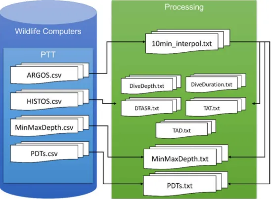
Raw position information was retrieved from the File “ARGOS.csv” which offers positioning information and quality flags of the location accuracy. These positions were subsequently interpolated linearly into a regular 10-minute-intervall and saved as “10min_interpolated.txt”. These interpolated positions were appended to dive-information according to the time stamps. The workflow is presented in Figure 1.
Figure 1: Processing of data towards PANGAEA-formatted files
The datasets of each PTT were excised according to provided starting date/time after the anesthesia of the animals and subsequent fitting of the instruments. The following dates/times determined the start of valid data (Table 1).
Table 1: Start date/time for the PTTs
Event label PTT Start DateTime (ISO 8601) S552016_ros_a_f_02 152416 2016-01-13T13:29:09 S552016_ros_a_f_11 152418 2016-01-22T12:08:59 S552016_ros_a_f_12 152414 2016-01-22T13:45:55 S552016_ros_a_f_15 152419 2016-01-22T19:31:19 S552016_ros_a_f_18 152413 2016-01-23T14:28:02 S552016_ros_a_f_19 152423 2016-01-23T20:47:01 S552016_ros_a_m_21 152422 2016-01-27T16:09:02
3 Processing Report
3.1 File description
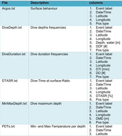
Table 2: Description of the delivered PANGAEA files
File Description columns
Argos.txt Surface behaviour 1. Event label
2. Date/Time 3. Latitude 4. Longitude 5. Pos type DiveDepth.txt Dive depths frequencies 1. Event label
2. Date/Time 3. Latitude 4. Longitude 5. Depth, water [m]
6. DDF [#]
7. Pos type DiveDuration.txt Dive duration frequencies 1. Event label
2. Date/Time 3. Latitude 4. Longitude 5. DTI [min]
6. DD [#]
7. Pos type DTASR.txt Dive-Time at surface-Ratio 1. Event label
2. Date/Time 3. Latitude 4. Longitude 5. DTASR [%]
6. Pos type MinMaxDepth.txt Dive maximum depth 1. Event label
2. Date/Time 3. Latitude 4. Longitude 5. DMD [m]
6. Pos type PDTs.txt Min- and Max-Temperature per depth 1. Event label
2. Date/Time 3. Latitude
4. Longitude 5. Depth, water [m]
6. TEMP [°C] MIN 7. TEMP [°C] MAX 8. Pos type
TAD.txt Time at depth 1. Event label
2. Date/Time 3. Latitude 4. Longitude 5. Depth, water [m]
6. DTD [min]
7. Pos type
TAT.txt Time at temperature 1. Event label
2. Date/Time 3. Latitude 4. Longitude 5. DTR [°C]
6. DTT [min]
7. Pos type
3.2 Argos.txt
A total number of 32142 messages was received and written to the file “Argos.txt”. The average lifetime of the PTTs was 192 days (with a range from 36 to 358 days). The average amount of messages per day was 23. Table 3 gives a summary of all processed data. Detailed maps and histograms of the location accuracies of the received messages are provided in the appendix (chapter 4 ).
Table 3: Summary of the processed PTTs
Event label First DateTime Last DateTime lifetime (days) messages S552016_ros_a_f_02 2016-01-13T13:29:09 2016-02-18T06:19:18 36 988 S552016_ros_a_f_11 2016-01-22T12:08:59 2017-01-13T14:07:15 358 9848 S552016_ros_a_f_12 2016-01-22T13:45:55 2016-05-16T13:07:46 115 3313 S552016_ros_a_f_15 2016-01-22T19:31:19 2016-03-19T20:28:22 58 642 S552016_ros_a_f_18 2016-01-23T14:28:02 2016-07-17T07:47:20 176 3827 S552016_ros_a_f_19 2016-01-23T20:47:01 2017-01-06T21:39:37 350 7326 S552016_ros_a_m_21 2016-01-27T16:09:02 2016-10-06T22:35:40 254 6198
3.3 Dive behaviour
Information of the dive behaviour is given in the output files “DiveDepth.txt”, “DiveDuration.txt”,
“TAT.txt”, “TAD.txt”, “MinMaxDepth.txt”, and “DTASR.txt”. These data were extracted from the files
“Histos.csv” and “MinMaxDepth.csv” and were available for up to six PTTs. The number of entries is shown in Table 4.
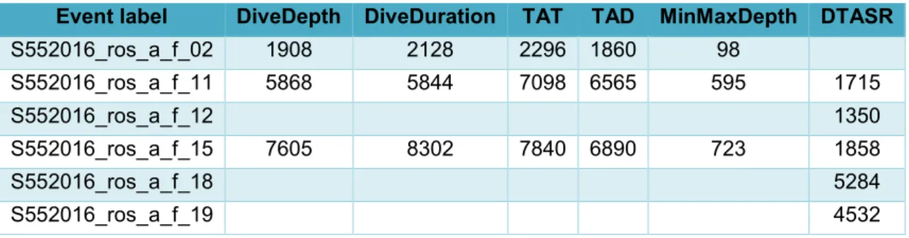
Table 4: Entries of the dive behaviour files
3.4 PDTs.txt
Data of depth and temperature is available for two PTTs, a summary of the entries is given in Table 5.
Table 5: Available CTD data Event label entries S552016_ros_a_f_12 2965 S552016_ros_a_f_18 3854
4 Appendix
4.1 Location accuracy classes
ARGOS location class PANGAEA location accuracy Description 1 Interpolated position
B 2 No estimate of location accuracy
A 3 No estimate of location accuracy
0 4 Estimated location accuracy > 1000 m
1 5 Estimated location accuracy 350 – 1000 m
2 6 Estimated location accuracy 150 – 350 m
3 7 Estimated location accuracy < 150 m
Event label DiveDepth DiveDuration TAT TAD MinMaxDepth DTASR
S552016_ros_a_f_02 1908 2128 2296 1860 98
S552016_ros_a_f_11 5868 5844 7098 6565 595 1715
S552016_ros_a_f_12 1350
S552016_ros_a_f_15 7605 8302 7840 6890 723 1858
S552016_ros_a_f_18 5284
S552016_ros_a_f_19 4532