Marine Mammals Tracking - MMT
Processing and Delivery report
Client: Dr. Horst Bornemann (AWI) Contractor: FIELAX GmbH
Contact:
Page 2 of 9
Content
1 Introduction ... 3
2 Workflow ... 3
2.1 Data retrieval ... 3
2.2 Data processing ... 4
3 Processing Report ... 5
3.1 File description ... 5
3.2 DSB.txt ... 6
3.3 Dive behaviour ... 6
3.4 CTD ... 6
4 Appendix ... 7
4.1 Location accuracy classes ... 7
4.2 Maps and histograms of all processed Weddell seals ... 8
1 Introduction
In January 2016
,four Weddell seals (Leptonychotes weddellii) were equipped with ARGOS Platform Transmitter Terminals (PTTs) during the RV “Polarstern” cruise PS96 (ANT-XXXI/2) in the Weddell Sea. The ARGOS satellite system provides positioning information during transmission and enables the download of different processing-level products via their web- interface.
All PTTs were additionally capable to measure dive activities and temperature as well as salinity of the water column (CTD). Information on the positions with location accuracy flags and additional dive/CTD date was obtained from the website of the Sea Mammal Research Unit (SMRU).
2 Workflow
2.1 Data retrieval
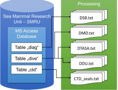
The SMRU data were downloaded from the website (http://www.smru.st-andrews.ac.uk/) as MS Access Databases (named “ct113.mdb” and “wd07.mdb”) and subsequently processed.
Page 4 of 9
2.2 Data processing
Raw position information was retrieved from the table “diag” which offers positioning information and quality flags of the location accuracy. The workflow is presented in Figure 1.
Figure 1: Processing of data towards PANGAEA-formatted files
The datasets of each PTT were excised according to provided starting date/time after the anesthesia of the animals and subsequent fitting of the instruments. The following dates/times determined the start of valid data (Table 1).
Table 1: Start date/time for the PTTs
Event label PTT Start DateTime (ISO 8601) DRE2015_wed_a_m_06 142938 2016-01-21T12:40:14 DRE2015_wed_a_f_07 142939 2016-01-21T12:42:42 DRE2015_wed_a_f_08 130064 2016-01-22T15:26:22 DRE2015_wed_a_m_10 146620 2016-01-23T15:41:30
3 Processing Report
3.1 File description
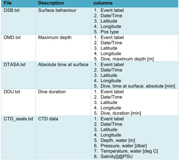
Table 2: Description of the delivered PANGAEA files
File Description columns
DSB.txt Surface behaviour 1. Event label 2. Date/Time 3. Latitude 4. Longitude 5. Pos type
DMD.txt Maximum depth 1. Event label
2. Date/Time 3. Latitude 4. Longitude
5. Dive, maximum depth [m]
DTASA.txt Absolute time at surface 1. Event label 2. Date/Time 3. Latitude 4. Longitude
5. Dive, time at surface, absolute [min]
DDU.txt Dive duration 1. Event label
2. Date/Time 3. Latitude 4. Longitude
5. Dive, duration [min]
CTD_seals.txt CTD data 1. Event label 2. Date/Time 3. Latitude 4. Longitude 5. Depth, water [m]
6. Pressure, water [dbar]
7. Temperature, water [deg C]
8. Salinity[]@PSU
Page 6 of 9
3.2 DSB.txt
A total number of 3044 messages was received and written to the file “DSB.txt”. The average lifetime of the four PTTs was 140.5 days (with a range from 75 to 204 days). The average amount of messages per day was 7. Table 3 gives a summary of all processed data. Detailed maps and histograms of the location accuracies of the received messages are provided in the appendix (chapter 0).
Table 3: Summary of the processed PTTs
Event label First DateTime Last DateTime lifetime (days)
messages DRE2015_wed_a_m_06 2016-01-21T12:40:14 2016-06-09T11:37:13 140 1101 DRE2015_wed_a_f_07 2016-01-21T12:42:42 2016-06-12T00:52:48 143 218 DRE2015_wed_a_f_08 2016-01-22T15:26:22 2016-08-13T10:52:29 204 684 DRE2015_wed_a_m_10 2016-01-23T15:41:30 2016-04-06T18:19:18 75 1041
3.3 Dive behaviour
Information of the dive behaviour is given in the output files “DMD.txt”, “DTASA.txt”, and “DDU.txt”.
These data were extracted from the table “dive” of the MS Access databases “ct113.mdb” and
“wd07.mdb” and were available for all PTTs. The number of entries is shown in Table 4:
Table 4: Entries of the dive behavior files Event label PTT entries DRE2015_wed_a_m_06 142938 3725 DRE2015_wed_a_f_07 142939 635 DRE2015_wed_a_f_08 130064 1935 DRE2015_wed_a_m_10 146620 1493
3.4 CTD
CTD data is available for all PTTs, a summary of the entries is given in Table 5.
Table 5: Available CTD data
DRE2015_wed_a_m_06 PTT entries DRE2015_wed_a_f_07 142938 4475 DRE2015_wed_a_f_08 142939 672 DRE2015_wed_a_m_10 130064 1628 DRE2015_wed_a_m_06 146620 4945
4 Appendix
4.1 Location accuracy classes
ARGOS location class PANGAEA location accuracy Description
1 Interpolated position
B 2 No estimate of location accuracy
A 3 No estimate of location accuracy
0 4 Estimated location accuracy > 1000 m
1 5 Estimated location accuracy 350 – 1000 m
2 6 Estimated location accuracy 150 – 350 m
3 7 Estimated location accuracy < 150 m
Page 8 of 9