FS Maria S. Merian - MSM79 Weekly Report 1
Edinburgh (UK) - Las Palmas (Gran Canaria) -
Mindelo (Kap Verden) 30.10.2018 - 09.11.2018 - 06.12.18
In the early afternoon of 30.10.2018, Maria S. Merian left the harbor area of Edinburgh for a cruise where research activities will focus on “organic carbon" and processes that steer its turnover. This cruise consists of two legs; EUROTHAW (Edinburgh - Las Palmas), which leads us to the Bay of Biscay, and MACPEI (Las Palmas - Mindelo), where research is planned in the Atlantic Ocean off Northwest Africa.
Despite that it is well known that carbon dioxide is an important greenhouse gas affecting our climate and that the ocean plays an important role in the global carbon cycle, many key processes regarding the entry/production, transport, deposition and degradation of organic carbon to and at the ocean floor as well as the carbon re-emission to the atmosphere, are not well understood. One of these processes which we want to study more closely, is the thawing of permafrost soils. This process is currently taking place in large parts of Siberia and northern North America as a result of today's global warming. Thawing permafrost soils can release large amounts of old carbon, much of which enters the ocean via river systems.
The impact of this release on marine ecosystems and the processes leading to the degradation and/or deposition of this carbon as well as the effects of this release on the global climate are largely unknown.
A method to obtain better insight into these processes is to study environmental and oceanographic signals that are archived in marine sediments. The goal of the first leg of MSM79 is to obtain high-resolution sediment archives that record the melting of European permafrost at the end of the last ice age approximately 20,000 years before present.
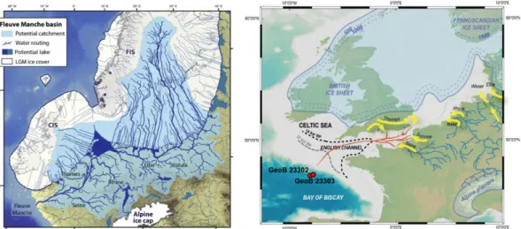
Figure 1. Map of Europa 20.000 years before present. Left: Drainage rivers of the continental ice (Patton et al., 2017), Right: Discharge direction of the Palaeo-river with core positions of MSM79 (after Ménot et al., 2006).
In the last ice age, large parts of Europe were covered by ice sheets, while the non-ice- covered ground was largely permanently frozen (Figure 1). The ice sheets were drained by
a huge river system which discharge waters flowed into the Atlantic Ocean. The river mouth of this palaeo-river was located in today's Bay of Biscay at the entrance of the English Channel.
Additional to meltwater, this palaeo-river also transported large quantities of erosional products. These sediments were deposited on terraces along the continental slope as well as in the deep sea. When permafrost began to thaw at the end of the last ice age, large amounts of old carbon, previously stored in the frozen soils, were released into the ocean.
On the early Friday afternoon of 02.11.2018 Maria S. Merian reached the working area in the Bay of Biscay at the position where the palaeo-river, the so-called "Fleuve Manche"
entered the Atlantic Ocean. Completely unexpected and in contrast to its bad reputation, the Bay of Biscay welcomed us in a most friendly way with blue skies, almost no wind and very low swells that gently moved the ship. The friendly welcome was subscribed by many dolphins that jumped around the ship. In other words; ideal sampling conditions.
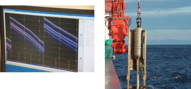
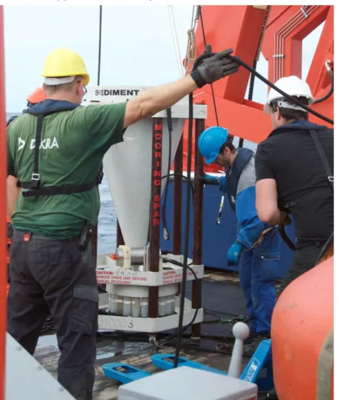
We happily accepted this welcome and started our research activities by studying the ocean floor morphology and its subsurface sediment with Parasound and Multibeam. After this we successfully deployed multicoring and gravity coring devices and were able to obtained surface sediments and four marine sediment archives at two selected core locations (Figure 2).
Figure 2. Left, Parasound Profile of the ocean floor in the research area, Right, The recovery of the gravity core GeoB 23303-2.
Due to the excellent cooperation of the researchers from the MARUM (Bremen), the AWI (Bremerhaven) and the Université Lille/CNRS (France) with the crew of the Maria S. Merian, the sampling was completed in the early hours of Saturday morning.
After termination of the research activities we send a goodbye to the Bay of Biscay and started our transit to Las Palmas. There we hope to enter port at the 09.11.2018 to welcome our colleges of the MARUM (Bremen), the AWI (Bremerhaven), the Royal Netherlands Institute of Sea Research (Texel, NL) and The Westminster University (London, UK), that will join us for the second leg of our cruise.
Many greetings from the Atlantic, On behalf of the scientific team Karin Zonneveld
FS Maria S. Merian, Cruise MSM 79 Weekly Report 2
Edinburgh (UK) - Las Palmas (Gran Canaria, ES) - Mindelo (Kap Verde) 30.10.2018 - 09.11.2018 - 06.12.18
In the second week of research cruise MSM 79, we completed the EUROTHAWs program in the Bay of Biscay and started a transit towards the south. After a short stay in Las Palmas, where the scientific team was completed, we traveled further to Cape Blanc (off northwest Africa), where the work of LEG 2, MACPEI is planned. There we hope to arrive in the early morning of 12.11.2018.
The planned research in this area focuses on the production, input, distribution, decomposition and deposition of carbon to and on the ocean floor. The aim is to investigate processes that determine the vertical flow of organic material (OM) and its changes in the water column of the Cape Blanc upwelling area off NW Africa. The scientific topics include a detailed investigation of phytoplankton succession, the formation as well as the vertical and lateral transport of particulate OM (POM) as a function of mineral dust and buoyancy. Furthermore we will investigate the degradation of POM under different redox conditions. This includes for instance the molecular alteration of POM and lipid biomarkers in the water column and the resulting influence on palaeoceanographic proxies.
The first activity in the research area will be the maintenance of long-term mooring stations that include a the dust collector and sediment traps off Cape Blanc.
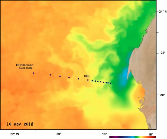
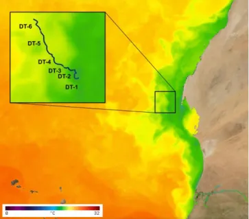
Furthermore we will start water column studies along a transect that runs from the coast to the open ocean (Figure 1).
Figure 1. Map depicting the current sea surface temperatures in the research area (source: NOAA-state of the Ocean) Low temperatures (blue and green colors) represent the distribution of freshly upwelled waters. The map furthermore depicts the planned research stations along a transect that runs from the coast to the open ocean as well as the position of the Sediment traps “CB” and “CBi” and the dust collector “Carmen”.
FS Maria S. Merian, Cruise MSM 79 Weekly Report 3
Edinburgh (UK) - Las Palmas (Gran Canaria, ES) - Mindelo (Kap Verde)
30.10.2018 - 09.11.2018 - 06.12.18
During the third week of the research cruise MSM 79 our scientific work focused on the production, entry as well as the dispersal, degradation and deposition of carbon on the ocean floor in the upwelling area off Cape Blanc.
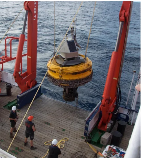
The favorable weather conditions allowed the station work in the research area to begin in the early morning of 12.11.2018, with the recovery of the buoy "Carmen". This buoy contains a dust collector that had collected dust for one year. This dust originates from the Sahara and is blown into the region at irregular intervals. The dust contains many trace elements that positively influence the bioproduction in the area. Furthermore, there is strong evidence that the dust input enhances the vertical transport of biogenic particles produced in the uppermost water column. In addition to the dust collector, the buoy is also equipped with a small meteorological station and a CTD, which recorded the weather and water conditions several hours a day over the last year.
Figure 1:
buoy Carmen
Thanks to the excellent cooperation between the crew of the Maria S. Merian's and the scientific and technical teams of the Royal Netherlands Sea Research Institute and MARUM, the 3-tonne buoy was successfully recovered and stood safely secured on deck in the afternoon.
Figure 2: Buoy Carmen is recovered
At night, the station work continued with water and sediment sampling. The next day, the sediment-trap mooring "CB" was successfully recovered. The sediment traps at this mooring collect particles from the water column which sediment to the seabed since 1988.
This provides important information about how particle flow has changed as a function of environmental and oceanographic changes. The mooring contains three sediment traps at 3635 m, 1235 m and 1135 m water depth. They collected particles over the last year at the same time intervals as the dust buoy "Carmen". It quickly turned out that both the dust collector and sediment traps worked perfectly. This is the best possible starting point for investigating the relationship between Sahara dust input and bioproduction as well as the vertical flux of organic and inorganic material in the water column.
Thanks to the very good weather conditions, both the dust buoy and sediment traps could be deployed already the following day. After they were cleaned and maintained they were returned to the Atlantic Ocean to collect Sahara dust and particles in the water column for another year.
In the second part of the week our research focused on microbial formation and degradation of particulate organic matter (POM) under different redox conditions.
Furthermore, we investigated the habitat and growth of the microorganism community, as well as the lateral/vertical transport of POM. Additionally, molecular alteration of POM and lipid biomarkers in the water column will be investigated.
The water column before Cape Blanc is characterized by a permanently present oxygen minimum zone. Furthermore, there are nepheloid layers - water layers, which have increased particle concentrations. Recent studies show that in these layers horizontal transport can take place from the shelf edge to the deep sea. It is however unknown, how far this particle transport exceeds into the open ocean and how long, and which particles remain "trapped" in these layers.
Figure 3: Mooring CB safely recovered
First, the exact location and thickness of the oxygen minimum zone and nepheloid layers in the water column was determined using a series of CTD profiles along a transect running from the coast to the open ocean. Thereafter, the nepheloid layers and water layers with different oxygen concentrations were specifically sampled using rosette and in- situ pumps. Immediately after collecting the water, incubation experiments were started to investigate microbial growth under different redox conditions.
At the end of the third week, a second mooring (CBi) with sediment traps was successfully recovered. This mooring has been collecting the vertical export flux of particles for 16 years. It is positioned where upwelling filaments regularly pass in the uppermost water layers. Also these sediment traps have worked perfectly and could be deployed again after cleaning and maintenance.
Meanwhile, we enjoy the wonderful summer weather with water and air temperatures over 25°C and very little wind. We look forward to the next week, where we aim to take a closer look at one of these upwelling filaments.
FS Maria S. Merian, Cruise MSM 79 Weekly Report 4
Edinburgh (UK) - Las Palmas (Gran Canaria, ES) - Mindelo (Kap Verde)
30.10.2018 - 09.11.2018 - 06.12.18
During the fourth week of research cruise MSM79, we were again accompanied by fantastic weather with decreasing winds and lots of sunshine. Although the low pressure cell, which had caused severe damage at the Canary Islands, caused a swell of more than four meters, our station work was not affected, since the individual waves were very long.
This week, we moved our research activities to a region closer to the Moroccan/Mauritanian coast. This region is characterized by the presence of permanent upwelling; waters which originate from the deep ocean being transported to the ocean surface. The local wind and flow conditions cause this freshly upwelled water to be transported further into the open ocean in the form of smaller and larger vortices and filaments. In contrast to the position of the active upwelling cells which have a more or less fixed position at the edge of the shelf, the vortices and filaments do not follow a fixed path.
Figure 1: Left, recovering a drifting trap in the morning of 21.11.2018. Right, the harvest of the trap that collected particles at 100m water depth.
In order to investigate how bioproductivity, the plankton community and vertical particle flow change during the movement from the upwelled water masses, we deployed drifting traps that collected the export flux of particles out of the surface waters at 100m, 200m, and 400m water depth. Using satellite records of water temperature, we determined the exact location of an active upwelling cell. In the early morning of November 19, we were about to deploy our drifting traps in the very center of this selected cell as we were surrounded by a fleet of local fishermen in small boats that had started to fish at exactly this position. To avoid our traps being captured in their fishing nets, we moved our deployment position a few miles in the direction of the open ocean to the edge of the
upwelling cell. There the traps, that were equipped with Iridium and AIS transmitters, were successfully deployed to collect particles for 24 hours. Their trajectory was tracked using the iridium satellite and VHF signals. The next day the traps were recovered and replaced by a second trap series. This continued for the rest of the week with the traps being replaced daily.
Figure 2: Track of the drifting traps off Cape Blanc (image courtesy of NASA and downloaded from the
“state of the ocean” website) .
During the rest of the days and nights, we continued our investigations of the vertical and lateral transport of biogenic particles, as well as their degradation within the water column and at the sediment-water interface. For this purpose, the CTD was used to determine the exact position and thickness of the oxygen minimum zone and the nepheloid layers (layers in the water column with increased particle concentrations) along the transect running from the coast to the open ocean. Subsequently, the nepheloid layers and the water layers with different oxygen concentrations were sampled by means of rosettes and in-situ pumps.
Immediately after collecting the water, "incubation experiments" were started. These
"incubation experiments" enable the study of the formation and growth of archaea and bacteria under different oxygen concentrations.
This weekend our work along the transect running from the coast to the open ocean and the particle flow of the upwelling cells and vortices is coming to an end.
During the night of Sunday to Monday, we will sample the nepheloid layers for the last time with in-situ pumps. Early Monday morning, we hope to recover the drift traps after which we will head south. There, in the second half of the next week, we intend to recover, service and deploy another dust buoy, as well as two sediment trap moorings southeast of the Cape Verde Islands.
Figure 3: Recovery of an In-situ pump
At the moment the renewed increasing wind speed and the presence of the cold upwelling water that surrounds the Maria S. Merian cause that the air temperature is slightly cooler (19°C) compared to the first half of the week. Therefore, we are all looking forward to the next week, for which the weather forecast promises us wonderful summer weather during the work on the moorings and buoy.
Zeer veel hartelijke groeten van de Atlantische Oceaan 21°07.350’ N, 17°59.251’ W (Wassertiefe 1682 m)
Karin Zonneveld
und Teilnehmer MSM 79