Forschungsschiff
MARIA S. MERIAN
Reisen Nr. MSM79 – MSM82 30. 10. 2018 – 24. 04. 2019
Kohlenstoff Freisetzung durch Tauen europäischer Permafrostböden, EUROTHAW
Marine Kohlenstoff Produktion, Transport und Erhaltung vor NW Afrika, MACPEI
Küstenauftriebssystem in einem sich wandelnden Ozean, CUSCO Falkland Sediment Drifts
Einsetzen und Modifikation in Pfaden und Intensitäten des Wassermassen- austauschs zwischen dem südöstlichen Pazifik und dem Südatlantik mit Fo- kus auf dem Falkland Plateau, nördlichen Scotia Bogen und West Georgia
Becken Rio Grande Rise
Ist der Rio Grande Rise ein Mikrokontinent oder die Spur des Tristan-Gough hot-spots?
Herausgeber
Institut für Geologie Universität Hamburg Leitstelle Deutsche Forschungsschiffe
http://www.ldf.uni-hamburg.de Gefördert durch
Deutsche Forschungsgemeinschaft (DFG)
Bundesministerium für Bildung und Forschung (BMBF) ISSN 1862-8869
- 2 -
Forschungsschiff / Research Vessel
MARIA S. MERIAN
Reisen Nr. MSM79 – MSM82 / Cruises No. MSM79 – MSM82 30. 10. 2018 – 24. 04. 2019
Kohlenstoff Freisetzung durch Tauen europäischer Permafrostböden Carbon release from thawing European permafrost
EUROTHAW
Marine Kohlenstoff Produktion, Transport und Erhaltung vor NW Afrika Marine carbon production, export and degradation off NW Africa,
MACPEI
Küstenauftriebssystem in einem sich wandelnden Ozean, CUSCO Coastal Upwelling System in a Changing Ocean, CUSCO
Falkland Sediment Drifts
Einsetzen und Modifikation in Pfaden und Intensitäten des Wassermassenaustauschs zwischen dem südöstlichen Pazifik und dem Südatlantik mit Fokus auf dem Falkland
Plateau, nördlichen Scotia Bogen und West Georgia Becken
Onset and modifications in intensity and pathways of water mass exchange between the Southeast Pacific and the South Atlantic with focus on the Falkland Plateau, Northern
Scotia Ridge and the West Georgia Basin Rio Grande Rise
Ist der Rio Grande Rise ein Mikrokontinent oder die Spur des Tristan-Gough hot-spots?
Is the Rio Grande Rise a microcontinent or the trail of the Tristan-Gough hotspot?
Herausgeber / Editor:
Institut für Geologie Universität Hamburg Leitstelle Deutsche Forschungsschiffe
http://www.ldf.uni-hamburg.de Gefördert durch / Sponsored by:
Deutsche Forschungsgemeinschaft (DFG)
Bundesministerium für Bildung und Forschung (BMBF) ISSN 1862-8869
- 3 -
Anschriften / Addresses
Prof. Dr. Karin Zonneveld Telefon: +49-421-21865797 Micropaleontology/Div. Marine Palynology Telefax: +49-421-2189865974 MARUM/Universität Bremen e-mail: kzonneveld@marum.de Leobener Straße 8
D-28359 Bremen
PD Dr. Holger Auel Telefon: +49 421 218 63040
BreMarE - Bremen Marine Ecology Telefax: +49 421 218 63055 Centre for Research and Education e-mail: hauel@uni-bremen.de Universität Bremen (FB 02)
P.O. Box 330 440
D-28334 Bremen Germany
Dr. Gabriele Uenzelmann-Neben Telefon: +49-471-4831-1208 Alfred-Wegener-Institut Telefax: +49-471-4831-1272
Helmholtz-Zenrum für Polar- e-mail: gabriele.uenzelmann-neben@awi.de
und Meeresforschung Am Alten Hafen 26 D-27568 Bremerhaven
Dr. Wolfram Geissler Telefon: +49-471-4831-1550 Alfred-Wegener-Institut Telefax: +49-471-4831-1149 Helmholtz-Zentrum für Polar- e-mail: Wolfram.Geissler@awi.de und Meeresforschung
Am Alten Hafen 26 D-27568 Bremerhaven
Leitstelle Deutsche Forschungsschiffe Telefon: +49-40-428-38-3640 Institut für Geologie Telefax: +49-40-428-38-4644
Universität Hamburg e-mail: leitstelle@ifm.uni-hamburg.de Bundesstraße 55 www.ldf.uni-hamburg.de D-20146 Hamburg
Reederei
Briese Schiffahrts GmbH & Co. KG Telefon: +49 491 92520 160 Abt. Forschungsschifffahrt Telefax +49 491 92520 169 Hafenstrasse 6d (Haus Singapore) e-mail: research@briese.de
D-26789 Leer www.briese.de/
Geschäftsstelle
des Gutachterpanels Forschungsschiffe (GPF) email: gpf@dfg.de c/o Deutsche Forschungsgemeinschaft
Kennedyallee 40 D-53175 Bonn
- 4 -
Forschungsschiff / Research Vessel MARIA S. MERIAN
Vessel’s general email address merian@merian.briese-research.de Crew’s direct email address n.name@merian.briese-research.de
Scientific general email address chiefscientist@merian.briese-research.de Scientific direct email address n.name@merian.briese-research.de
Each cruise participant will receive an e-mail address composed of the first letter of his first name and the full last name.
Günther Tietjen, for example, will receive the address:
g.tietjen@merian.briese-research.de Notation on VSAT service availability will be done by ship’s management team / system operator.
Data exchange ship/shore : on VSAT continuously / none VSAT every 15 minutes
Maximum attachment size: on VSAT no limits / none VSAT 50 kB, extendable on request
The system operator on board is responsible for the administration of all email addresses
Phone Bridge (Iridium Open Port) +881 631 814 467
(VSAT) +49 421 944 024 391 1
- 5 -
MERIAN Reisen / MERIAN Cruises MSM79 – MSM82
30. 10. 2018 – 24. 04. 2019
Kohlenstoff Freisetzung durch Tauen europäischer Permafrostböden Carbon release from thawing European permafrost, EUROTHAW Marine Kohlenstoff Produktion, Transport und Erhaltung vor NW Afrika Marine carbon production, export and degradation off NW Africa, MACPEI
Küstenauftriebssystem in einem sich wandelnden Ozean, CUSCO Coastal Upwelling System in a Changing Ocean, CUSCO
Falkland Sediment Drifts
Einsetzen und Modifikation in Pfaden und Intensitäten des Wassermassenaustauschs zwischen dem südöstlichen Pazifik und dem Südatlantik mit Fokus auf dem Falkland
Plateau, nördlichen Scotia Bogen und West Georgia Becken
Onset and modifications in intensity and pathways of water mass exchange between the Southeast Pacific and the South Atlantic with focus on the Falkland Plateau, Northern
Scotia Ridge and the West Georgia Basin Rio Grande Rise
Ist der Rio Grande Rise ein Mikrokontinent oder die Spur des Tristan-Gough hot-spots?
Is the Rio Grande Rise a microcontinent or the trail of the Tristan-Gough hotspot?
Fahrt / Cruise MSM79 30.10.2018 – 03.12.2018
Edinburgh (Scotland) - Mindelo (Cape Verde) Fahrtleiter / Chief Scientist:
Prof. Dr. Karin Zonneveld Fahrt / Cruise MSM80 23.12.2018 – 30.01.2019
Balboa (Panama) – San Antonio (Chile) Fahrtleiter / Chief Scientist:
Dr. Holger Auel
Fahrt / Cruise MSM81 02.02.2019 – 15.03.2019
San Antonio (Chile) – Montevideo (Uruguay) Fahrtleiter / Chief Scientist:
Dr. Gabriele Uenzelmann-Neben Fahrt / Cruise MSM82 18.03.2019 – 24.04.2019
Montevideo (Uruguay) – Montevideo (Uruguay) Fahrtleiter / Chief Scientist:
Dr. Wolfram Geissler
Koordination / Coordination Leitstelle Deutsche Forschungsschiffe Kapitän / Master MERIAN MSM79 – Ralf Schmidt
MSM80 – Björn Maaß MSM81 - MSM82 – Ralf Schmidt
- 6 -
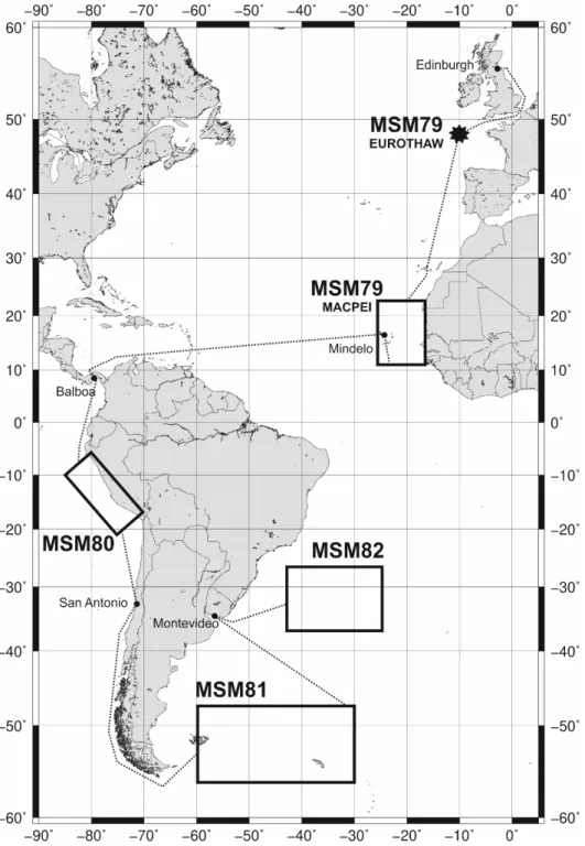
Abb. 1: Geplante Fahrtrouten und Arbeitsgebiete der MERIAN Expeditionen MSM79 Fig. 1: Planned cruise tracks and working areas of MERIAN cruises MSM79.
- 7 -
Wissenschaftliches Programm
Scientific Programme
Fahrt / Cruise MSM79
Übersicht Fahrt MSM79 EUROTHAW
Permafrostböden enthalten große Mengen Kohlenstoff, der durch die dauerhaften Tem- peraturen unter dem Gefrierpunkt gut erhal- ten wird. Wenn durch Tauen des Permafrosts dieser Kohlenstoff freigesetzt wird, wird das Material bioverfügbar und trägt wahrschein- lich zum Anstieg des atmosphärischen CO2- Gehalts bei. Es wird erwartet, dass durch den anthropogenen Klimawandel der Permafrost in der Arktis taut und der darin enthaltene Kohlenstoff freigesetzt wird. Eine analoge Situation stellt der Übergang aus der letzten Eiszeit in die heutige Warmzeit dar, während dessen die großen Eisschilde schmolzen und Permafrostlandschaften, z.B. in Mitteleuro- pa, sich zu den heutigen Landschaften des ge- mäßigten Klimabereichs wandelten.
Kohlenstoff aus tauendem Permafrost kann als CO2 Gas, als gelöster organischer Koh- lenstoff oder in Form von Partikeln freige- setzt werden und in marinen Sedimenten er- halten bleiben. Diese Sedimente können als Archive dienen, die den Vorgang des Perma- frosttauens dokumentieren. Jedoch können Sedimentarchive nur dann zweifelsfrei tauen- dem Permafrost zugeschrieben werden, wenn das terrigene organische Material in ihnen sehr alt ist.
Ziel dieser Nebennutzerfahrt ist die Gewin- nung eines Sedimentkerns an einer Position an der Mündung des Englischen Kanals, wo während des letzten Deglazials ein großer Teil der europäischen Tundra entwässerte, und die komponentenspezifischen 14C-Al- tern von terrigenen organischen Biomarkern zu ermitteln sowie mit palynologischen Me- thoden die Entwicklung von Tundra zu der heute vorherrschenden Vegetation nachzu- vollziehen.
Synopsis
Cruise MSM79 EUROTHAW
Permafrost soils store vast amounts of frozen carbon, which, when released by thawing during climate warming, becomes bioavaila- ble and likely contributes to atmospheric CO2
increase. This process is expected to occur in the future and mainly in the Arctic resulting from anthropogenic climate change. An ana- logue situation prevailed during the last de- glaciation, when warming caused glaciers to melt and permafrost tundra regions, which extended much further south than today, transformed into the biomes we know today.
One such region is the European tundra.
Carbon release from thawing permafrost can occur as emissions of CO2 gas, as dissolved organic matter, or as particles. The latter have to potential to be preserved in marine sediments and can serve as archive of the process of permafrost carbon mobilization.
Sediment records of increased carbon accu- mulation can only unambiguously be at- tributed to permafrost thaw, if ancient terri- genous organic matter can be found.
The purpose of this ancillary cruise is to col- lect a sediment core at a position off the out- flow of the English Channel, which drained much of the European tundra during the last deglaciation. We intent to obtain a record of terrigenous organic matter accumulation paired with compound-specific radiocarbon ages of terrigenous biomarkers. In addition, we plan to perform palynological analyses to reconstruct the vegetation dynamics during this drastic environmental change, when the tundra was transformed to the modern Euro- pean biome.
- 8 - MACPEI
Viele Aspekte der „marinen biologischen Kohlenstoffpumpe“ - der Prozess, in dem CO2 zu organischem Material umgewandelt, durch sinkende Partikel exportiert und ab- schließend im tiefen Ozean versenkt wird, sind immer noch unklar. Forschergruppen vom MARUM (Bremen), dem Alfred-Wege- ner-Institut (Bremerhaven), der University of Westminster (London, UK) und des Royal Netherlands Institute for Sea Research (Texel, NL) wollen Prozesse studieren, die den vertikalen Fluss von organischem Mate- rial (OM) während des Transports, ihren Ver- änderungen in der Wassersäule und beim Ab- sinkprozess im Cape Blanc Auftriebsgebiet vor NW Afrika formen.
Die geplanten wissenschaftlichen Themen umfassen die Untersuchungen von Phyto- plankton-Sukzessionen, die Bildung und der vertikale und laterale Fluss von partikularem OM (POM) in Abhängigkeit von Mineral- staub und Auftrieb, die mikrobielle Bildung sowie der Abbau von POM bei unterschiedli- chen Redoxbedingungen, Habitats und Wachstumsstudien von Zooplankton und Mi- kroorganismengemeinschaften als auch der laterale/vertikale Transport und molekulare Veränderung des POM und Lipidbiomarkern in der Wassersäule und des daraus resultie- renden Einflusses auf paläozeanographische Proxies. Die Studien werden durch einen in- novativen Ansatz von Partikelstudien mittels optischer und akustischer Sensoren unter- stützt. Geplant ist, Wasser-, Plankton-, POM- und Sedimentproben in Bereichen von Auf- triebszellen und –wirbeln und entlang eines von der Küste zum offenen Ozean verlaufen- den Transekts zu erhalten. Weiterhin dient die beantragte Ausfahrt zur Wartung von Langzeitverankerungen der Staubkollektoren und Sedimentfallen vor Cape Blanc.
MACPEI
Many aspects of the marine biological car- bon pump - the process by which CO2 is transformed to organic carbon, exported through sinking particles and finally seques- tered in the deep ocean - are still not clear.
Research groups of the MARUM (Bremen), the University of Westminster (London, UK), the Alfred-Wegener-Institute Bremerhaven and the Royal Netherlands Institute for Sea Research (Texel, NL) will jointly study pro- cesses shaping the vertical organic matter (OM) flux as well as the transport and alter- ation of OM in the water column and during the settling process in the Cape Blanc upwelling area off NW Africa.
They will study the phytoplankton succession in freshly upwelled waters, the formation, vertical and lateral flux of POM in relation- ship to mineral dust input and upwelling, the microbial production and OM degradation in deeper waters at differential redox condi- tions, the depth habitat and flux feeding of zo- oplankton and microbial community as well as the lateral displacement and molecular al- teration of POM and lipid-based biomarkers in water column and sediments and its effect on palaeoceanographic proxies. For this an innovative combined approach of particle studies using optical and acoustic systems will be used. We will collect water, plankton, POM and sediments along transects follow- ing the path of upwelling eddies/filaments and along an onshore-offshore transect. Fur- thermore, long-term moored dust collectors and sediment traps will be serviced.
- 9 - Fahrt MSM80
Im Rahmen des BMBF-finanzierten Ver- bundvorhabens CUSCO - "Küstenauftriebs- system in einem sich wandelnden Ozean"
werden während der Reise MSM80 Produk- tivität und Nahrungsbeziehungen im Hum- boldtauftriebssystem vor Peru untersucht, um die Ursachen des im Vergleich zu anderen Küstenauftriebssystemen extrem hohen Fi- schereiertrags zu ergründen und die Frage zu beantworten, wie sich das System in Folge des globalen Klimawandels verändern wird.
Fahrt MSM81
Durch die Öffnung der Drake Passage und der Scotia See wurde ein Wassermassenaus- tausch zwischen dem südlichen Pazifik und dem Südatlantik ermöglicht. Auf diese Weise kam es zu einem Transfer von Wärme und Energie zwischen den beiden Ozeanen. In Kombination mit der Öffnung des Tasman Gateways wurde die Entwicklung des antark- tischen Zirkumpolarstroms (ACC) und somit eine thermische Isolation der Antarktis mög- lich, welches als eine Hauptursache für den Einsatz weitreichender Vereisungen disku- tiert wird. Sowohl die tektonischen Bewe- gungen in der Drake Passage und der Scotia See als auch klimatische Veränderungen ha- ben zu Modifizierungen in Intensität und Pfad des ACCs und der Wassermassen, wel- che der ACC umfasst, geführt. Das Einsetzen des ACCs sowie diese Modifizierungen sind in sedimentären Strukturen dokumentiert, die auf dem Falkland Plateau abgelagert wurden.
Eine Untersuchung dieser Sediment Drifts, welche durch zirkumpolares Tiefenwasser, Weddell-See-Tiefenwasser und antarktisches Bodenwasser geformt wurden, mit hochauf- lösenden reflexionsseismischen Methoden wird zu Information über Veränderungen der ozeanischen Zirkulation als Folge tektoni- scher Bewegungen und Klimaänderungen führen. Ein weiteres Ziel der Expedition MSM 81 ist die Erfassung von site survey Daten für ein IODP proposal, welches die früheste Phase des Wassermassenaustauschs über die Drake Passage untersuchen wird.
Cruise MSM80
In the framework of the BMBF-funded joint research project CUSCO - "Coastal Upwelling System in a Changing Ocean", during the cruise MSM80, productivity and trophic interactions will be studied in the Humboldt Current Upwelling System off Peru in order to elucidate the reasons for the extremely high fisheries yield compared to other coastal upwelling regions and to answer the question how the system will respond to global climate change.
Cruise MSM81
The opening of Drake Passage and the Scotia Sea enabled the exchange of water masses between the southern Pacific and the South Atlantic. In this way heat and energy could be transferred between the two oceans. To- gether with the opening of the Tasman Gate- way this allowed the establishment of the Ant- arctic Circumpolar Current (ACC) thermally isolating Antarctica, which has been consid- ered as one of the major causes for the onset of widespread glaciation. Both tectonic movements within Drake Passage and the Scotia Sea as well as modifications in climate have led to changes in intensity and pathway of the ACC and the water masses flowing within it. The onset of the ACC and those changes have been documented in sedimen- tary structures deposited on the Falkland Plateau. A study of the sediment drifts shaped by Circumpolar Deepwater, Weddell Sea Deepwater and Antarctic Bottomwater using high-resolution seismic reflection data will provide information on modifications of the circulation resulting from tectonic move- ments and changes in climate. Additionally, we will collect site survey data for an IODP proposal set on studying the earliest phase of water mass exchange via Drake Passage.
- 10 - Fahrt MSM82
Der Rio Grande Rise (RGR) besteht aus ei- nem umfangreichen Plateau und einer ausge- dehnten Seamount-Provinz im SW-Atlantik und wurde bisher für eine Large Igneous Pro- vinz gehalten, die sich durch magmatische Aktivität des Tristan-Gough Mantelplumes auf der Südamerikanischen Platte gebildet hat. Neue Untersuchungen zeigen, dass der RGR ein Stück kontinentaler Kruste sein kann, welches während der Öffnung des Süd- atlantiks geriftet und vom südamerikanischen Kontinent nach Osten bewegt wurde, so dass das Plume-Modell überflüssig wäre. Hier schlagen wir eine kombinierte seismische, geochemische, geo- und thermochronologi- sche Untersuchung der Erdkruste des RGR vor, um die Hypothese eines von tektoni- schen und magmatischen Prozessen über- prägten Kontinentsplitters zu testen. Dabei sollen die 1000 km langen Rift- und Vulkan- strukturen des RGR und der Jean Charcot Sea mounts nach Anzeichen von Mantelplume- Aktivität und dem Bildungsalter der Gesteine untersucht werden. Die Ergebnisse werden wichtige Erkenntnisse für das Verständnis des Aufbrechens von Kontinenten und der Bildung von Ozeanbecken sowie der Rolle von Mikrokontinenten bei der Bildung von Hotspot-Spuren liefern.
Cruise MSM82
The Rio Grande Rise (RGR) is a massive plateau and seamount province in the SW At- lantic that has been assumed to represent a large igneous province formed by volumi- nous magmatic activity of the Tristan-Gough mantle plume on the South American plate.
But new evidence showing that the RGR might be a sliver of continental crust that was captured, and possibly rifted, at the time of continental breakup, is throwing considera- ble doubt on a hotspot origin. We propose a combined seismic, geochemical, geo- and thermochronological study of the nature of the deep and shallow RGR basement to test our hypothesis that the RGR is a microconti- nent that has been modified by a complex tec- tonic and magmatic history, including 1000 km long rifts, associated with buoyant plume upwelling and formation of the Jean Charcot Seamount Chain. These data will determine the relative amounts of continental and oce- anic crust, age and origin of the volcanic rocks, and chemical changes with time. The results will have important implications for the understanding of continental rifting and opening of ocean basins and the role of mi- crocontinents in the formation of hotspot trails.
- 11 -
Von Edinburgh / From Edinburgh –
Nach Mindelo / To Mindelo Fahrt / Cruise MSM79
Wissenschaftliches Programm EUROTHAW
Während dieser Nebennutzerfahrt soll ein Sedimentkern an der Mündung des Engli- schen Kanals gewonnen werden, der Aus- kunft geben soll über die Akkumulationsrate des terrigenen Materials sowie gleichzeitig das komponenten-spezische 14C-Altern von terrigenen organischen Biomarkern ermittelt.
Während des letzten Deglazials entwässerte ein großer Teil der europäischen Tundra durch den Englischen Kanal. Frühere Studien haben gezeigt, dass an der vorgesehenen Se- dimentkernposition während des Deglazials sehr hohe Akkumulatiosraten terrigenen or- ganischen Materials vorherrschten, jedoch konnte das Alter dieses Materials noch nicht nachgewiesen werden. Weiterhin soll mit pa- lynologischen Methoden die Vegetations- sukzession rekonstruiert werden.
MACPEI
Während der geplanten Fahrt werden fol- gende Ziele verfolgt:
a. Ermittlung der Produktion von ausge- wählten Phytoplanktongruppen (Cocco- lithophoren und Zysten bildende Dino- flagellaten), Mikroben- und Zooplank- tonvergesellschaftungen in Bezug auf Auftrieb und Staubeintrag in den Ozean.
b. Bestimmen der Rate des vertikalen und lateralen Transports verschiedener Grup- pen von Palynomorphen, Phytoplankton, Mikroben und Zooplankton in Bezug auf den Ort und das Vorhandensein von ak- tiven Auftriebszellen, Wirbeln/Filamen- ten und Nepheloidschichten in der obe- ren und tieferen Wassersäule.
c. Bestimmen der Kohlenstoffassimilati- ons- und Lipidbiosyntheseraten von he- terotrophen und autotrophen Archaea und Bakterien bei verschiedenen Redox- und Nährstoffbedingungen in der Was- sersäule und dem entsprechenden Ober- flächensediment.
Scientific Programme EUROTHAW
During this ancillary cruise we will collect a sediment core off the outflow of the English Channel, which drained much of the Euro- pean tundra during the last deglaciation.
This core will allow the determination of ter- rigenous organic matter accumulation as well as the determination of the compound- specific radiocarbon ages of terrigenous bi- omarkers. Evidence for increased terri- genous organic matter accumulation at this site during the deglaciation exists, but it re- mains to be shown that this sediment contains ancient terrigenous C. Furthermore, palyno- logical analyses of the sediments will be per- formed to reconstruct the vegetation dynam- ics during this drastic environmental change, when the tundra was transformed to the mod- ern European biome.
MACPEI
During the envisaged cruise the following aims will be addressed:
a. determine the succession of export pro- duction formed by selected phytoplankton groups (coccolithophores and cyst form- ing dinoflagellates), microbial and zoo- plankton communities in relationship to upwelling succession and dust fertiliza- tion of the ocean.
b. determine the rate of vertical and lateral transport of different groups of palyno- morphs, phytoplankton, microbes and zo- oplankton in relation to the location and presence of active upwelling cells, ed- dies/filaments and nepheloid layers in the upper and deeper water column.
c. determine carbon assimilation and lipid biosynthetic rates of heterotrophic and autotrophic archaea and bacteria at dif- ferent redox and nutrient conditions in the water column and the corresponding surface sediment.
- 12 - d. Untersuchung von Umwelteinflüssen
auf die Produktion von Archaea-Lipi- den, die die Grundlage für häufig in pa- läozeanographischen Studien verwen- dete Temperaturproxys, wie TEX86, bil- den.
e. Bestimmung der Lipid- und Kohlen- stoffisotope sowie der makromolekula- ren und isotopischen Eigenschaften von partikulärem organischem Material in Bezug auf Sauerstoffkonzentrationen in der Wassersäule und der Sediment- Wasser-Grenzfläche und ihre Auswir- kungen auf paläozeanographische Pro- xies.
d. Examine environmental impacts on and export mechanisms of archaeal lipids that form the basis for temperature proxies frequently used in paleoceanographic studies, such as TEX86
e. Determine the lipid and carbon isotopic inventory in and alteration of the macro- molecular and isotopic characteristics of particulate organic matter in relation to oxygen concentrations in the water col- umn and at the sediment-water interface and its effects on palaeoceanographic proxies.
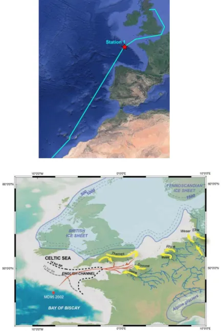
Abb. 2: Arbeitsgebiet EUROTHAW und Entwässerungsströme des tauenden Permafrosts in der europäischen Tundra
Fig. 2: Station map EUROTHAW marking the direction of the melted permafrost of the Euro- pean Tundra.
- 13 -
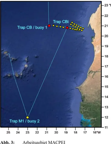
Abb. 3: Arbeitsgebiet MACPEI Fig. 3: Working Area MACPEI.
Arbeitsprogramm Workprogram
EUROTHAW
Um die oben genannten Ziele zu erreichen, werden wir am Kontinentalhang der nordwest- lichen Biskaya bei 47 ° 27'N, 8 ° 32'W in 2200 m Wassertiefe Oberflächen- und Untergrund- sedimente gewinnen, wobei ein Multicorer eingesetzt wird, um Sedimente der ruhenden Oberfläche zu erhalten. Die Erfassung der der- zeitigen Situation kann mit den geochemischen Aufzeichnungen (Biomarkerkonzentrationen, verbindungsspezifische Radiokohlenstoffda- ten von terrigenen Biomarkern) und mit paly- nologischen Daten verglichen werden. Ferner soll ein Sedimentkern zur Beprobung mittels Schwerelot gewonnen werden.
MACPEI
Die Probenahme wird in der Kap-Blanc-Re- gion anhand der folgenden Strategien durchge- führt.
EUROTHAW
To achieve the above mentioned goals we will obtain surface and subsurface sediments at the continental slope of the northwest Bay of Biscay, at 47°27’N, 8°32’W in 2200 m water depth. A multicorer shall be deployed to ob- tain undisturbed surface sediments. This will allow the assessment of the modern situation against which any geochemical records (bi- omarker concentrations, compound-specific radiocarbon dates of terrigenous bi- omarkers) and palynological data can be compared. Furthermore a sediment core shall be obtained by gravity coring.
MACPEI
Sampling will be executed in the Cape Blanc region using the following sampling strate- gies.
- 14 - 1. Die obere Wassersäule, die den OM-Parti-
kelfluss der Auftriebsfolge und des Stau- beintrags widerspiegelt, wird entlang von Transekten, die den Auftriebsgewässern folgen, mit Driftfallen, CTD / Rosetten- Profilierung und In-situ-Pumpen durchge- führt.
2. Der Anteil des vertikalen und lateralen Transports von Partikeln und die Verände- rung der organischen Substanz sowie die mikrobielle Aktivität in Bezug auf das Vorhandensein von Nepheloidschichten und differenziellen Redoxbedingungen in der Wassersäule und an der Sediment- Wasser-Grenzfläche wird gemessen an- hand von 12 Stationen entlang eines Ons- hore-Offshore-Transekts einschließlich der Fallenpositionen CB und CBi mit CTD-Profilierung, In-situ-Pumpen und Multicorer-Probenahme.
3. Die langfristigen Veränderungen dieser Prozesse werden anhand von Sedimentfal- len und Staubbojen untersucht.
1. The upper water column that shape the OM particle flux in relationship to upwelling succession and dust input, sampling will be carried out along tran- sects that follow the tracks of upwelled waters with drifting traps, CTD/Rosette profiling and in-situ pumps.
2. The rate of vertical and lateral transport of particles and alteration of the organic matter as well as microbial activity in re- lationship to the presence of nepheloid layers and differential redox conditions in the water column and at the sediment- water interface will be assessed by 12 sta- tions along an onshore-offshore transect including also the trap positions CB and CBi using CTD profiling, in-situ Pumps and Multicorer Sampling.
3. The long-term variability of the system will be studied using sediment trap and dust buoy samples.
- 15 -
Zeitplan / Schedule Fahrt / Cruise MSM79
Tage/days Auslaufen von Edinburgh (Schottland) am 30.10.2018
Departure from Edinburgh (Scotland) 30.10.2018
Transit zum Arbeitsgebiet / Transit to working area 3
Arbeitsgebiet 1 / working area 1 1
Transit zum Zwischenhafen Las Palmas (Spanien)
Transit to intermediate port Las Palmas (Spain) 4
Transit zum Arbeitsgebiet 2 / Transit to working area 2 2
Arbeitsgebiet 2 / working area 2 23
Transit zum Hafen Mindelo (Kap Verden) 2
Transit to port Mindelo (Cape Verde)
Total 35 Einlaufen in Mindelo (Kap Verden) am 03.12.2018
Arrival in Mindelo (Cape Verde) 03.12.2018
- 16 -
Von Balboa / From Balboa –
Nach San Antonio / To San Antonio Fahrt / Cruise MSM80
Wissenschaftliches Programm
Küstenauftriebssysteme gehören zu den produktivsten Ökosystemen im Meer. Sie stellen 7% der marinen Primärproduktion und sogar 20% des weltweiten marinen Fischereiertrags auf <2% der Fläche des Weltozeans. Trotz ähnlicher Auftriebsinten- sitäten und ähnlicher Primärproduktions- raten pro Flächeneinheit in den vier großen Küstenauftriebsgebieten, erzielt das Auf- triebsgebiet des Humboldtstroms einen acht- bis zehnmal höheren Fischereiertrag pro Flächeneinheit als die anderen.
Die Ursachen für diese extrem hohe Pro- duktivität an der Spitze der Nahrungskette zu ergründen und zu ermitteln wie diese Mechanismen auf den globalen Klimawandel reagieren werden, sind die übergreifenden Ziele des BMBF-finanzierten Verbund- forschungsvorhabens „CUSCO – Küsten- auftriebssystem in einem sich wandelnden Ozean - Trophische Transfereffizienz des Humboldtauftriebssystems vor Peru". Die CUSCO-1 Forschungsreise (MSM80) ist die erste Feldkampagne dieses Forschungs- projektes. Biologische Meereskundler und physikalische Ozeanographen arbeiten zusammen mit Meeresökologen, Biogeo- chemikern und Fischereiwissenschaftlern, um Kohlenstoff- und Energieflüsse durch das marine Nahrungsnetz zu verfolgen und um das Rätsel zu lösen, warum das Humboldt- auftriebssystem acht- bis zehnmal höhere Fischereierträge liefert als andere Küsten- auftriebsgebiete trotz ähnlicher Primär- produktionsraten.
Hauptziel der Expedition ist es herauszu- finden, welche Prozesse und Mechanismen die trophische Transfereffizienz (TTE) be- stimmen und damit die Struktur des Nah- rungsnetzes, die Gemeinschaftszusammen- setzung und Energieflüsse beeinflussen so- wie potenzielle regionale Unterschiede in der
Scientific Programme
Eastern Boundary Upwelling Systems (EBUS) are among the most productive ma- rine ecosystems, providing 7% of total ma- rine primary production and 20% of global marine fish landings, but accounting for <2%
of the ocean area. Although the four major EBUS have similar upwelling intensities and similar primary productivity per unit area, the Humboldt Upwelling System (HUS) pro- vides eight to ten times higher fisheries yields per unit area than the other systems.
To elucidate the reasons for this extremely high productivity at upper trophic levels and how the mechanisms will respond to global climate change is the overarching objective of the BMBF-funded joint research project CUSCO - "Coastal Upwelling System in a Changing Ocean - Trophic Transfer Effi- ciency of the Humboldt Current Upwelling System off Peru". The CUSCO-1 research cruise (MSM80) will be its first fieldwork campaign. Biological and physical oceanog- raphers will cooperate with marine ecol- ogists, biogeochemists, and fisheries scien- tists in order to trace carbon and energy fluxes through the marine food web and to study how different upwelling intensities af- fect overall trophic transfer efficiency (TTE).
We will thrive to solve the enigma of why the Humboldt upwelling system provides eight to ten times higher fisheries yield than other coastal upwelling systems at similar primary production rates.
Major aim of the cruise is to establish which processes and mechanisms determine TTE and, hence, affect food-web structure, com- munity composition and trophic pathways, and to study potential regional differences within the Peruvian upwelling system related to differences in upwelling intensity and wa- ter mass distribution. We will quantify major
- 17 - Auftriebsintensität und Wassermassenvertei- lung innerhalb des peruanischen Auftriebs- gebietes zu untersuchen. Wir werden Nah- rungsflüsse quantifizieren und die folgenden Themen behandeln:
(i) Phytoplanktonzusammensetzung und Pri- märproduktion bei unterschiedlichen Auf- triebsregimen.
(ii) Länge der Nahrungskette zwischen Pri- märproduzenten und kommerziell genutzten Arten mittels trophischer Biomarker (stabile Isotope, Fettsäuren).
(iii) Rolle von Filtrierern (z.B. Krill). Da Filtrierer effizient ein breites Spektrum von Beutegrößen fressen, führen sie zu einem we- niger komplexen Nahrungsnetz mit insge- samt höherer TTE.
(iv) Gelatinöses Zooplankton, da es oft zu einer "Sackgasse" in der Nahrungskette führt und Räuber und Konkurrenten für pelagische Fische darstellt.
(v) Abundanz, Verteilung und Beutespek- tren von pelagischen und mesopelagischen Fischen.
(vi) Auswirkungen physikalisch-biologischer Grenzschichten (mesoskalige Wirbel, Auf- triebsfilamente, Grenzen der Sauerstoff- minimumzone) auf die Zooplanktondyna- mik.
trophic pathways by covering the following topics:
(i) Phytoplankton composition and primary production under different upwelling re- gimes.
(ii) Length of the food chain between primary producers and harvested species via trophic biomarkers (stable isotopes, fatty acids).
(iii) Role of filter feeders (e.g. krill). Since fil- ter feeders efficiently consume a wide range of prey sizes, they form less complex food webs with a higher overall TTE.
(iv) Gelatinous zooplankton, since they are often "dead ends" of the food chain and pred- ators and competitors for small pelagic fish.
(v) Abundance, distribution and prey spectra of pelagic and mesopelagic fishes.
(vi) Effects of physical-biological boundaries (meso-scale eddies, upwelling filaments, margins of the oxygen minimum zone) on zo- oplankton dynamics.
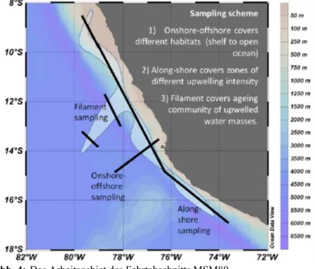
Abb. 4: Das Arbeitsgebiet des Fahrtabschnitts MSM80.
Fig. 4: Working area of cruise MSM80.
- 18 - Arbeitsprogramm
Während MSM80 werden ca. 50 Stationen zwischen 8°30'S 79°40'W und 17°00'S 73°30'W beprobt (Abb. 4), sowohl auf dem Schelf (200 m Wassertiefe), als auch über dem Kontinentalhang (1000 m) entlang der peruanischen Küste, um Regionen mit unter- schiedlicher Auftriebsintensität abzudecken.
Ein weiterer Transekt von der Küste in den offenen Ozean dient der Verfolgung einer al- ternden Auftriebsfahne. Wiederholte Schnit- te über ein Auftriebsfilament ermöglichen Prozessstudien. Die Verteilung der Wasser- massen, hydrographische Parameter und Nährstoffe werden mittels CTD-Profilen an jeder Station bestimmt. Zusätzliche Infor- mationen zur vertikalen Vermischung wer- den durch Mikrostrukturmessungen mit ei- nem MSS-Profiler gewonnen. Eine ge- schleppte CTD (ScanFish) wird eingesetzt, um hydrographische Daten in hoher Auf- lösung an Wassermassengrenzen und Fron- ten zu erfassen. Die zeitliche Entwicklung ei- nes Auftriebsfilaments wird mit einer Drift- boje beobachtet.
Wasserproben werden mit einem Kranzwas- serschöpfer gesammelt für die Messung an- organischer Nährstoffe, suspendiertem Mate- rials, partikulärem organischen Kohlenstoffs, Stickstoffs und Phosphors (POC, PON, POP), biogenem Silikats (BSi), sowie Phytoplanktonabundanz und -zusammenset- zung (mittels Durchflusszytometrie, Mikro- skopie, HPLC Pigmentanalyse). Wasser- proben werden an Bord inkubiert zur Be- stimmung der Primärproduktion und Stick- stofffixierung.
Abundanz, Biomasse, Biodiversität und Artenzusammensetzung des Zoo- und Ich- thyoplanktons sowie der pelagischen Fische werden mittels stratifizierter bzw. ge- schleppter Fänge mit verschiedenen Mehr- fachschließnetzen (Hydro-Bios Multinetz, MOCNESS) sowie Hols mit dem Isaac-Kidd Midwater Trawl (IKMT) bestimmt. Zu- sätzlich werden optische Planktonprofiler (Underwater Vision Profiler, LOKI) ein- gesetzt. Individuen der Zooplankton- Schlüsselarten werden für Fressexperimente und Respirationsmessungen an Bord genutzt, um ihre individuellen Energiebedarfe zu
Work Program
During MSM80, about 50 stations will be sampled between 8°30'S 79°40'W and 17°00'S 73°30'W (Fig. 4) on the continental shelf (200 m water depth) and above the con- tinental rise (1000 m) along the Peruvian coastline to cover regions with different upwelling intensity. In addition, an onshore- offshore section off Callao will be studied to follow an aging upwelling plume, and time will be reserved for process studies such as repeated sections across an upwelling fila- ment. The distribution of source water masses of upwelling, hydrographic parame- ters and nutrients will be obtained by CTD casts at each station. Additionally, infor- mation about diapycnal mixing will be gath- ered by microstructure measurements with an MSS profiler. A towed CTD (ScanFish) is used to supply high resolution hydrographic data at water mass boundaries and fronts.
The temporal evolution of upper layer dy- namics in an upwelling filament will be ob- served with a drifting surface mooring.
Water samples will be collected by rosette water sampler casts for measurements of in- organic nutrients, suspended matter, particu- late organic carbon, nitrogen and phospho- rus (POC, PON, POP), biogenic silica (BSi) as well as phytoplankton abundance and composition (using flow cytometry, micros- copy, HPLC pigment analysis). Water col- umn samples will be incubated on board for determination of primary production and ni- trogen fixation.
Abundance, biomass, biodiversity and spe- cies composition of zoo- and ichthyoplankton as well as small pelagic fish will be deter- mined based on stratified vertical hauls or double oblique hauls with multiple open- ing/closing net systems (Hydro-Bios Multi- net, MOCNESS) and an Isaac-Kidd Midwa- ter Trawl (IKMT). In addition, optical plank- ton profilers (Underwater Vision Profiler, LOKI) will be deployed. Specimens of zoo- plankton key species will be used for feeding experiments and respiration measurements on board to establish their individual energy
- 19 - quantifizieren (Winkler-Titration, Optoden- Respirometrie).
Zur quantitativen Bestimmung der Nah- rungsspektren werden Individuen an Bord aus den Fängen aussortiert und bei -80°C eingefroren für die Analyse trophischer Biomarker (Fettsäuren, stabile Isotope).
Räuber-Beute-Beziehungen und Nahrungs- netzstrukturen des pelagischen Ökosystems werden mittels der Verhältnisse stabiler Isotope von Stickstoff und Kohlenstoff (δ15N, δ13C) untersucht. Dieser Ansatz liefert Informationen zur Nahrungsquelle und zur Trophiestufe, um Energieflüsse durch das pelagische Nahrungsnetz zu verfolgen und die trophische Transfereffizienz wichtiger Räuber-Beute-Beziehungen zu bestimmen.
demands (Winkler titration, optode respirom- etry).
For the quantitative determination of dietary spectra, specimens will be sorted from the catches and deep-frozen at -80°C for trophic biomarker analysis (fatty acids and stable isotopes). Predator-prey relationships and food-web structure of the pelagic ecosystem will be studied by stable isotope ratios of ni- trogen and carbon (δ15N, δ13C). This ap- proach provides information on the dietary source and trophic levels in order to trace en- ergy flows through the pelagic food web and to establish trophic transfer efficiencies for major predator-prey interactions.
- 20 -
Zeitplan / Schedule Fahrt / Cruise MSM80
Tage/days Auslaufen von Balboa (Panama) am 23.12.2018
Departure from Balboa (Panama) 23.12.2018
Transit zum Arbeitsgebiet / Transit to working area 4
Küstenauftriebssytem des Humboldtstroms vor Peru 30
Humboldt Current coastal upwelling system off Peru
Transit zum Hafen San Antonio (Chile) 4
Transit to port San Antonio (Chile)
Total 38 Einlaufen in San Antonio (Chile) am 30.01.2019
Arrival in San Antonio (Chile) 30.01.2019
- 21 -
Von San Antonio / From San Antonio –
Nach Montevideo / To Montevideo Fahrt / Cruise MSM81
Wissenschaftliches Programm
Expedition MSM81 verfolgt zwei Hauptzie- le:
1) Das Studium der Variationen in Pfaden und Intensitäten der Tiefen- und Boden- wassermassen als Folge von
a) tektonischen Bewegungen und
b) Klimaänderungen; hierbei handelt es sich um den Hauptfokus der Reise, und
2) das Erfassen von pre-site survey Daten für IODP proposal 862-pre.
Ziel 1: Rekonstruktion der Variationen in Pfaden und Intensität von Tiefen- und Bodenwassermassen.
Tiefen- und Bodenwassermassen innerhalb des Antarktischen Zirkumpolarstroms ACC werden durch die komplexe Topographie der Drake Passage und der Scotia See gelenkt.
Beim Umfließen von topographischen Hoch- lagen reduzieren sie ihre Geschwindigkeit und deponieren Sedimente. In Klüften und Passagen hingegen wird die Geschwindigkeit erhöht, was zu Erosion und Nicht-Ablage- rung führt. Auf diese Weise formen die Was- sermassen sogenannte Sediment Drifts, welche in ihrer Struktur die Modifikationen in Pfad und Intensität der Wassermassen dokumentieren. Die tektonische Entwicklung der Drake Passage und Scotia See im Käno- zoikum haben zu starken Veränderungen in den Pfaden der Wassermassen geführt, welche durch die Analyse von Sediment Drifts entschlüsselt werden können.
Der ACC ist zusätzlich Schwankungen durch glaziale-interglaziale Zyklen unterworfen.
Auch dies hat zu Verlagerungen in den Depozentren geführt, welche über seismische Untersuchungen identifiziert werden können.
Ergebnisse von DSDLP Leg 36 und 71 deuten auf eine Intensivierung der Boden- strömungen im Eozän, was die Diskussion eines früh-tertiären Wassermassenaustau- sches zwischen Pazifik und Atlantik ange- stoßen hat. Numerische Simulationen indi- zieren ebenfalls einen schwachen ACC in der
Scientific Programme
The overaching goals of the cruise are two- fold: we will
1) study variations in flow paths and intensi- ties of deep and bottom water masses in re- sponse to
a) tectonic movements, and
b) climate variability; this is the major focus of the cruise, and
2) collect pre-site survey data for IODP pro- posal 862-Pre.
Objective 1: Reconstruct variations in flow path and intensities of deep and bottom water masses.
The deep and bottom water masses flowing within the ACC are steered by the complex topography of the Drake Passage and the Scotia Sea. Rounding topographic highs the water masses reduce their speed and hence deposit sediment. In gaps and passages their speed is increased leading to erosion and non-deposition. In this way the aforemen- tioned water masses shape sediment drifts, which in their structure document the modifi- cations in the flow paths and intensities of the water masses. The tectonic development of both the Drake Passage and the Scotia Sea during the Cenozoic have led to strong mod- ifications in the flow paths, which, when stud- ying sediment drifts, can be deciphered.
Additionally, the ACC fronts are assumed to have been subject to relocations during gla- cial-interglacial cycles. This again has led to relocations in depocentres, which can be identified via seismic profiles. Results of DSDP Legs 36 and 71 suggest intensified bottom currents as early as the Eocene, which led to the discussion of an early Ter- tiary water mass exchange between the Pa- cific and the Atlantic oceans. Numerical sim- ulations also suggest a weak ACC for the late Cretaceous but no overturning circulation.
- 22 - späten Kreide, aber keine Umwälzzirkula- tion.
Folgende Fragen sollen beantwortet werden:
Wann und in welcher Form beeinflusste der einsetzende ACC und die Tiefen- und Bodenwassermassen innerhalb des ACC die Sedimentation auf dem Falkland Plateau?
Für welchen Zeitraum können die frühesten Überfließungssignale des UCDW und LCDW, welche Transport von kalten Wassermassen in den Südatlantik andeuten, identifizieren?
Wie sind die Variationen der Pfade und Intensitäten des Überfließens und die Lokation des ACC in Relation zu a) tektonischen Bewegungen und b) Modifikationen im Klima?
Ziel 2: Pre-site survey für IODP proposal 862 IODP proposal 862-pre schlägt vor, einen Tiefentransekt im subantarktischen Süd- atlantik auf dem östlichen Falkland Plateau mit paläogenen Sequenzen zu erbohren.
Diese Gegend stellt im modernen Ozean eine kritische Region für Vermischung und Aus- tausch von tiefen Wassermassen zwischen Pazifik und Atlantik durch die Drake Passage dar. Die geplanten Bohrlokationen sollen den Zusammenhang zwischen lokaler tektoni- scher Absenkung von Tiefenwasserbarrieren, Klimaänderungen in hohen Breiten und Einsetzen von Bodenwasserproduktion im Weddell Meer sowie die Ausbreitung nach Norden dokumentieren. Diese Entwicklung zusammen mit der beginnenden ACC Zirkulation hat die känozoische Zirkulation im Atlantik massiv verändert.
Eine der Herausforderungen in der Palä- ozeanographie des Südozeans ist die Loka- tion von signifikanten Bohrsites. Hochauf- lösende reflexionsseismische Daten sollen im Rahmen der Expedition MSM81 erfasst
The questions we intend to answer are the fol- lowing:
When and how did the onset of the ACC and the deep and bottom water masses flowing within the ACC affect sedimentation at the Falkland Plateau area?
When can we recognise the first overspill of UCDW and LCDW over the Falkland Plateau indicating transport of cold water masses into the South Atlantic?
What are the variations of the pathways and intensity of overspill and the location of the ACC fronts in relation to a) tectonic movements, and b) modifications in climate (e.g. Mid-Miocene Climatic Optimum and Transition, Pliocene warming, onset of widespread glaciation on the Northern Hemisphere)?
Objective 2: Pre-site survey for developing a full IODP proposal built on IODP 862-Pre IODP preliminary proposal 862-Pre (PIs Westerhold and Bohaty) proposes to drill a depth transect of Paleogene sites in the sub- antarctic South Atlantic Ocean on the eastern Falkland Plateau (Maurice Ewing Bank and Georgia Basin). In the modern ocean, this is a critical area for deep-water mixing and communication between the Pacific and At- lantic oceans across the Drake Passage, with local bathymetry controlling the dispersal and propagation of deep- and bottom-waters throughout the Atlantic. The target sites will be positioned to assess the relationships be- tween local tectonic subsidence of deep-wa- ter barriers, high-latitude climate change, and the onset of bottom-water production in the Weddell Sea and northward propagation into to the deep western Atlantic. This devel- opment along with the onset of the ACC cir- culation fundamentally altered Cenozoic ocean circulation in the Atlantic.
One of the challenging elements of high lati- tude Southern Ocean palaeoceanography is site selection. In order to choose sites, where a sedimentary column appropriate to achieve the goals of a full IODP proposal can be
- 23 - werden, um geeignete Lokationen auszu- wählen.
drilled, high-resolution seismic data are needed.
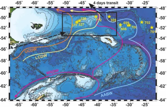
Abb. 5: Fahrtroute und Arbeitsgebiet MSM81.
Fig. 5: Cruise track and working area of cruise MSM81
Arbeitsprogramm
Um die aufgestellten wissenschaftlichen Fra- gen zu beantworten, werden hochauflösende reflexionsseismische Daten auf dem Falkland Plateau, der Maurice Ewing Bank und in der Falkland Passage erfasst. Auf diese Weise wird das Auffinden und die Abbildung von Sediment Drifts möglich, welche durch Tie- fen- und Bodenwasser geformt wurden. Die seismischen Profile werden weiterhin die Lo- kationen von DSDP Leg 36 Sites 327 und 329 sowie Leg 71 Sites 511 und 512 umfassen, um eine Korrelation der seismischen Daten mit geologischer Information, welche an den Sites erbohrt wurde, zu ermöglichen und ein Alters-Tiefenmodell zu entwickeln.
Parasound und Multibeam-Bathymetrie Da- ten werden ebenfalls im Arbeitsgebiet erho- ben.
Work Program
To answer the raised scientific questions we will collect a grid of high-resolution seismic profiles on the Falkland Ridge between a) the Falkland Islands and MEB, and b) MEB, the NEGR and South Georgia. This set of seismic lines will enable the detection and imaging of sediment drifts shaped by UCDW west of MEB and shaped by LCDW and WSDW east of MEB. The seismic lines will further cross the locations of DSDP Leg 36 Sites 327 and 329 and Leg 71 Sites 511 and 512 to allow the correlation of the acquired seismic data with geological information (lithology, sedi- ment composition, grain sizes, etc) and to de- velop age-depth models.
Parasound and multibeam bathymetric data will also be collected.
- 24 -
Zeitplan / Schedule Fahrt / Cruise MSM81
Auslaufen von San Antonio (Chile) am 02.02.2019 Departure from San Antonio (Chile) 02.02.2019
Transit zum Arbeitsgebiet / Transit to working area 9
Seismische und bathymetrische Profilarbeiten im Gebiet des Falkland Plateaus, Maurice
Ewing Bank, Falkland Passage 27
Seismic and bathymetric profiling in the area of the Falkland Plateau, the Maurice Ewing
Bank, and the Falkland Passage
Transit zum Hafen Montevideo 4
Transit to port Montevideo
Total 40 Einlaufen in Montevideo (Uruguay) am 15.03.2019
Arrival in Montevideo (Uruguay) 15.03.2019
- 25 -
Von / From Montevideo –
Nach / To Montevideo Fahrt / Cruise MSM82
Wissenschaftliches Programm
Inzwischen gibt es begründete Zweifel daran, dass der Rio Grande Rise (RGR) auf einen Mantelplume zurückgeht. Roberto Ventura Santos, Geological Survey of Brazil (pers.
Mttlg.) berichtet über Hinweise, dass es sich um ein Fragment Gondwanas handeln könnte.
Diese Möglichkeit wird durch die jüngste Entdeckung kontinentaler Fragmente in hotspot-Spuren im Indischen Ozean gestützt.
2012 und 2013 haben japanische und brasilianische Forscher mit dem Tauchboot Shinkai 6500 einen 100 m2 großen Bereich aus Granit und Gneis in ca. 1000 m Tiefe neben großen Mengen an Quarzsand entdeckt. Das Ausmaß des Granitvorkommens und die Dicke seiner Alterationkruste sowie die Menge an Sand, die für den Ozeanboden untypisch ist, lässt darauf schließen, dass es sich nicht um abgeworfenes Ballast-Gestein von Schiffen handelt.
Eine ausgeprägt negative Bouguer Anomalie unter dem RGR deutet an, dass große Teile des WRGR von kontinentaler Kruste unter- lagert werden, die während des Riftings zwischen Südamerika und Afrika eingefangen wurde.
Allerdings kann die Annahme, dass der RGR ausschließlich ein Produkt der Bildung eines Mikrokontinents ist, nicht erklären, wie es zur Bildung der darüber und daneben liegenden 1000 km langen Jean Charcot seamount chain (JCSC) gekommen ist. Diese ist wohl die zu erwartende Spur eines langlebigen Mantelplumes.
Folgende Hypothesen sollen mittels gravi- metrischen und seismischen Daten in Kom- bination mit Geochemie und Geochronology getestet werden:
Ist der Rio Grande Rise ein Mikrokonti- nent oder eine hotspot-Spur oder beides?
Scientific Programme
Significant doubts have arisen about a mantle plume origin for the RGR, because of recent evidence that it is a fragment of Gondwanaland (Roberto Ventura Santos, Geological Survey of Brazil, personal communication) and the discovery of con- tinental fragments in hotspot trails in the Indian Ocean In 2012 and 2013 Japanese and Brazilian researchers using the manned submersible Shinkai 6500 found a slab of granite and gneisses around 100 m2 at a depth of roughly 1000 meters, to- gether with silica-rich metamorphic rocks and a large expanse of quartz sand. The size of the granite slab, its thick altera- tion, and the presence of quartz sand, un- known on the seafloor, indicates that it is highly unlikely to be ballast jettisoned from a ship.
The negative Bouguer gravity anomaly un- der the RGR implies that much of the WRGR is underlain by continental crust, captured during rifting of South America from Africa.
However, assuming that the Rio Grande Rise is exclusively the result of microcontinent for- mation cannot explain the overlying/adjacent 1000 km-long bending Jean Charcot sea- mount chain, which seems to be a classic trail of a long-lived mantle plume.
In detail, we will use gravity and seismic measurements combined with geochemical data to test the following hypotheses:
Is the Rio Grande Rise a microcontinent or a hotspot track or both?
- 26 - Seismische Profile über den RGR und Cru- zeiro do Sul Lineament (CdSL) sollen folgen- de Fragestellungen beantworten:
Abgrenzung von Bereichen ozeanischer und kontinentaler Kruste durch den Ver- gleich von Geschwindigkeits-Tiefen- Funktion.
Wie ist der Übergang von RGR zur oze- anischen Kruste?
Wurde das CdSL wesentlich durch mag- matische Intrusionen verändert?
Ist das CdSL ein alter kontinentaler Rift- graben oder entstand er durch großräumige Plattenreorganisation?
Geochemische und geo- bzw. thermo-chro- nologische Fragen:
Korreliert die Verteilung ozeanischer und kontinentaler Kruste mit Variationen der Geschwindigkeits-Tiefen-Funktion?
Gibt es Hinweise auf Mantelplumes wäh- rend des Riftings?
Wie ist die Zusammensetzung und die Ent- wicklung der Mantelquelle?
Ist die Jean Charcot Seamount Chain eine hotspot-Spur?
Seismische Fragestellungen:
Bildete sich die JCSC an Schwachstellen, die Schmelzen kanalisierten?
Hat der zugrunde liegende Mantel plume die umgebende Lithosphäre beein- flusst?
Geochemische, geochronologische Frage- stellungen:
Ist die JCSC eine kontinuierlich fortschrei- tende hotspot-Spur?
Wie vergleichbar sind Alter und Zusam- mensetzung zwischen JCSC, RGR und Walvis Ridge?
Was sagt die geochemische Variation in der Zeit aus über Entwicklung der Man- telquelle, Temperatur des oberen Mantels und Einfluss der Lithosphärendicke?
Seismic experiments across the RGR and Cruzeiro do Sul Lineament (CdSL) will pro- vide constraints on the following questions:
Determine areas of continental and oceanic crust by comparing velocity-depths func- tions.
Termination of the RGR against oceanic crust.
Has the CdSL been modified significantly by magmatic intrusions?
Is the CdSL an old continental rift graben or due to major plate reorganizations?
Geochemistry, geo- and thermos chronology questions:
Does the distribution of oceanic and conti- nental crust correlate with variations in the velocity-depth functions?
Is there evidence for a mantle plume during rifting?
Chemical evolution and composition of man- tle source of oceanic crust.
Is the Jean Charcot Seamount chain a hotspot trail?
Seismic experiments questions:
Did the JCSC form where lines of weakness channeled melts?
Does the mantle plume responsible for the JCSC significantly influence the surround- ing lithosphere?
Geochemical, geochronological questions:
Is the JCSC a progressive hotspot trail?
Comparison of age and composition be- tween JCSC, RGR and Walvis Ridge.
What does geochemical variation with time tell us about the evolution of mantle source composition, upper mantle temperature and the effects of lithosphere thickness?
- 27 -
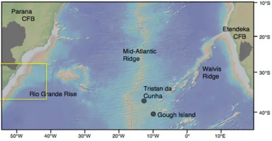
Abb. 6: Das Arbeitsgebiet von Ausfahrt MSM82 östlich von Brasilien.
Fig. 6: The working area of cruise MSM82 east of Brazil.
Arbeitsprogramm Tiefenseismik
Mittels Tiefenseismik wird die Verteilung und jeweilige Dicke von kontinentaler und ozeanischer Kruste sowie ihre Rolle bei dem Aufbau von RGR, CdSL und JCSC be- stimmt. Vor allem die tiefere Struktur des CdSL ist von besonderem Interesse, da das Lineament sehr ungewöhnlich für ein ozeani- sches Plateau ist. Falls das RGR tatsächlich ein Mikrokontinent sein sollte, könnte das CdSL der Überrest eines Grabens sein, der sich während der Öffnung des Südatlantiks und der Rotation des RGR in seine heutige Position gebildet hat. Wir werden diese Strukturen entlang von drei seismischen Pro- filen untersuchen:
1) Das erste wird die JCSC nahe des brasilia- nischen Kontinentalrandes überdecken. Im Falle eines Mantelplumes im Untergrund er- warten wir dicke ozeanische Kruste, andern- falls normal mächtige Kruste. Wenn die seis- mische Linie keine nennenswerten Änderun- gen der Krustendicke belegt, muss die Hypo- these, dass ein Plume (Tristan-Gough) bei der Bildung dieses Teils des RGR beteiligt war, in Frage gestellt werden. Dieses Profil ist sehr kurz und es werden nur 20 OBS mit ei- nem Abstand von 15 km ausgesetzt.
Work Program
Deep Seismic sounding experiment
The seismic experiment will provide constraints on the distribution and thickness of continental and oceanic crust and its role in the formation of the RGR, CdSL and JCSC.
The deeper structure of the CdSL is of particular interest because it is so unusual for an oceanic plateau. If the RGR is a microcontinent, the CdSL might represent a rift graben, which formed during the opening of the South Atlantic and the rotation of the RGR into its current position. We will investigate these structures at three locations.
1) The first profile will cross the JCSC close to the Brazilian continental margin.
Depending on the resulting model, we expect to find thick oceanic crust in areas influenced by a mantle plume. Otherwise we expect to find normal oceanic crust, which might vary across the fracture zone crossing this track of this proposed line. If the line shows no significant crustal variations, the hypothesis that a major mantle plume (Tristan-Gough) was involved in formation of this part of the RGR must be questioned. This profile is rather short, and only 20 OBS with a spacing of 15 km will be deployed.
- 28 - 2) Die zweite seismische Linie wird das RGR, CdSL und das Nordende von JCSC kreuzen. Sie soll die Herkunft der beobachte- ten Schwankungen in der Bouguer-Schwere- anomalie klären (Abb. 5). Ferner sollen die Daten zeigen, wie tief die Kruste durch das CdSL beeinflusst wurde, ob dieses Gebiet aus ausgedehnter kontinentaler Kruste besteht und wie stark es durch Mantelplume-indu- zierte magmatische Intrusionen und Riftpro- zesse verändert wurde. Genau datierte Vulka- nite aus den Dredgeproben können über die Änderung der Geschwindigkeits-Tiefen- Funktion mit Variabilität des unterlagernden Basements korreliert werden. Es sind 30 OBS mit einer Entfernung von jeweils 18 km ge- plant.
3) Ein drittes Profil über das Südostende des CdSL streift den tieferen Teil des ERGR.
Dieser Teil des CdSL scheint ein deutlich ausgebildeter Riftgraben zu sein, dessen ge- naue Natur und dessen Ursprung unbekannt ist. Die seismischen Daten und die Gesteins- proben sollen klären, ob es Teil eines konti- nentalen Rifts ist, oder es sich um durch bis- her ungeklärte Prozesse modifizierte ozeani- sche Kruste handelt. Geplant sind 25 OBS mit einem Abstand von 15 km.
Hochaufgelöste Bathymetrie
Vom Arbeitsgebiet sind nur spärliche hoch- auflösende Bathymetriedaten vorhanden, weswegen wir das Gebiet so intensiv wie möglich kartieren wollen. Die Daten werden während der Transitstrecken und den seismi- schen Profilen erhoben. Die JCS seamounts und die vermeintlichen Riftstrukturen des RGR werden per Dredge beprobt und diese Gebiete werden im Detail kartiert, um die Strukturen zu verstehen und die Beprobung genau planen zu können. Parasound-Sedi- mentecholotdaten sollen davor schützen, in reinen Sedimentgegenden zu dredgen.
2) The second profile will cross the RGR, CdSL and the northern end of the JCSC. It will allow us to determine the reason for the pronounced variation in the Bouguer anomaly (Fig. 5) Furthermore, the data will show how deeply the crust has been modified by the CdSL, if the area consists of extended continental crust, and how strongly it has been modified by plume-related magmatic intrusions and rifting. Changes in the composition of precisely dated volcanism (RGR, CdSL and JCSC) revealed by dredge sampling can be correlated with variations in the underlying basement structure via changes in the velocity-depth functions. This is the main profile, and in total 30 OBS with a spacing of 18 km will be used.
3) A third profile crosses the SE end of the CdSL located on a subdued (lower relief) part of the ERGR. This part of the CdSL seems to be pronounced rift graben, the nature and origin of which is completely unknown. The seismic data and rock sampling will allow to establish whether it is part of a continental rift zone or oceanic crust modified by unknown tectonic processes. We prefer to use here 25 OBS with a spacing of 15 km.
High-resolution bathymetry
There is little detailed high-resolution bathymetry data available in the working area and thus we intend to map as much as possible of the RGR and Jean Charcot Seamounts during transit and seismic profiling. Furthermore, several of the Jean Charcot Seamounts will be sampled by dredging and these structures will be mapped in detail to understand the structures and provide a basis for decisions where to sample. Similarly, we intend to map portions of the apparent rift structures of the RGR during transiting between the dredge stations in order to better understand their tectonic formation and guide the dredge sampling. We will also use Parasound sediment echosounder data to avoid dredging in sedimented areas.
- 29 - Gesteinsbeprobung für Geochemie, Geo- und Thermochronologie
Entlang des JCSC und CdSL werden sea- mounts mit der Dredge beprobt. Es wird er- wartet, dass es sich bei den seamounts um vulkanische Strukturen mit steilen Hängen und wenig Sedimentüberlagerung auf diesen handelt, so dass sie lohnenswerte Ziele für das Dredging sein sollten. Im Falle des CdSL wurden Granite und andere kontinentale, aber auch basaltische Gesteine mit Dredgen vom westlichen Ende des CdSL gewonnen (Eugénio Pires Frazão, pers. Mitt.). Deswe- gen werden wir das Ostende des CdSL bepro- ben, wo es das WRGR durchschlägt. Die tie- fen, riftartigen Strukturen im RGR gehen ver- mutlich auf tektonische Bewegungen zurück und sind daher ideal für die Beprobung tiefe- rer Krustenabschnitte mittels der Dredge.
Tiefseebiologie
Das geborgene petrologische Material in den Dredgen wird außerdem biologisch ausge- wertet. Darüber hinaus werden biologische Probenahmen an ausgewählten Lokationen auf dem Rio Grande Rise und in der umge- benden Tiefsee durchgeführt.
Rock sampling, geochemistry, geo- and thermochronology
We will dredge and sample seamounts along the JCSC and CdSL. We expect the seamounts to be volcanic structures with steep flanks and little to no sediment cover and, thus, they should be good dredging targets. In the case of the CdSL granites and other continental rocks, as well as basaltic rocks, have been sampled by dredging from along the western end of the CdSL (Eugénio Pires Frazão, personal communication). We will, therefore, sample its eastern end cross cutting the WRGR. Tectonic movements apparently caused the steep rift-like structures in the RGR and these are ideally suited for dredge sampling of the deeper levels of the crust.
Deep-sea biology
We will also carry out biological studies analyzing the recovered petrological material from the dredges. Furthermore, dedicated biological sampling is planned at selected sites at the Rio Grande Rise and in the surrounding deep sea.