Forschungsschiff
MARIA S. MERIAN
Reisen Nr. / Cruises No. MSM68/2 – MSM70 04. 11. 2017 – 04. 02. 2018
Sammlung von atmosphärischen Referenzmessungen über Ozeanen, CARO
Struktur und Entwicklung Ozeanischer Lithosphäre, LITHOS-iLAB
Intraplattenvulkanismus der Bathymetrists-Seamounts und der Effekt auf die geochemische Entwicklung ozeanischer Kruste, BathyChem
Herausgeber
Institut für Geologie Universität Hamburg Leitstelle Deutsche Forschungsschiffe
http://www.ldf.uni-hamburg.de Gefördert durch
Deutsche Forschungsgemeinschaft (DFG)
Bundesministerium für Bildung und Forschung (BMBF) ISSN 1862-8869
Forschungsschiff / Research Vessel
MARIA S. MERIAN
Reisen Nr. / Cruises No. MSM68/2 – MSM70 04. 11. 2017 – 04. 02. 2018
Sammlung von atmosphärischen Referenzmessungen über Ozeanen
Collecting Atmospheric Reference Data over Oceans, CAROStruktur und Entwicklung Ozeanischer Lithosphäre
Structure and Evolution of the Oceanic Lithosphere, LITHOS-iLAB
Intraplattenvulkanismus der Bathymetrists-Seamounts und der Effekt auf
die geochemische Entwicklung ozeanischer Kruste
Intraplate Volcanism of the Bathymetrists Seamounts and its Effect on the Geochemical Evolution of Oceanic Lithosphere, BathyChem
Herausgeber / Editor:
Institut für Geologie Universität Hamburg Leitstelle Deutsche Forschungsschiffe
http://www.ldf.uni-hamburg.de Gefördert durch / Sponsored by:
Deutsche Forschungsgemeinschaft (DFG)
Bundesministerium für Bildung und Forschung (BMBF) ISSN 1862-8869
- 2 -
Anschriften / Addresses
Dr. Stephanie Fiedler Telefon: +49 40 41173 416 Max-Planck Institut für Meteorologie e-mail:
Bundesstr. 53 stephanie.fiedler@mpimet.mpg.de
20146 Hamburg
Prof. Dr. Ingo Grevemeyer Telefon: +49-431-600-2336
GEOMAR Telefax: +49-431-6002922
Helmholtz-Zentrum für Ozeanforschung e-mail: igrevemeyer@geomar.de
Wischhofstrasse 1-3 http: www.geomar.de
D-24148 Kiel
Dr. Froukje M. van der Zwan Telefon: +49 431 880 1628 Institut für Geowissenschaften Telefax: +49 431 880 4376
an der Universität Kiel e-mail: fvdz@gpi.uni-kiel.de Ludewig-Meyn-Str. 10
24118 Kiel
Leitstelle Deutsche Forschungsschiffe Telefon: +49-40-428-38-3640 Institut für Geologie Telefax: +49-40-428-38-4644
Universität Hamburg e-mail: leitstelle@ifm.uni-hamburg.de Bundesstraße 55 http: www.ldf.uni-hamburg.de D-20146 Hamburg
Reederei
Briese Schiffahrts GmbH & Co. KG Telefon: +49 491 92520 160 Abt. Forschungsschifffahrt Telefax +49 491 92520 169 Hafenstrasse 6d (Haus Singapore) e-mail: research@briese.de
26789 Leer http: http://www.briese.de/
Geschäftsstelle
des Gutachterpanels Forschungsschiffe (GPF) e-mail: GPF@dfg.de c/o Deutsche Forschungsgemeinschaft
Kennedyallee 40 53175 Bonn
- 3 -
Forschungsschiff / Research Vessel MARIA S. MERIAN
Vessel’s general email address merian@merian.briese-research.de Crew’s direct email address n.name@merian.briese-research.de
Scientific general email address chiefscientist@merian.briese-research.de Scientific direct email address n.name@merian.briese-research.de
Each cruise participant will receive an e-mail address composed of the first letter of his first name and the full last name.
Günther Tietjen, for example, will receive the address:
g.tietjen@merian.briese-research.de Notation on VSAT service availability will be done by ship’s management team / system operator.
• Data exchange ship/shore : on VSAT continuously / none VSAT every 15 minutes
• Maximum attachment size: on VSAT no limits / none VSAT 50 kB, extendable on request
• The system operator on board is responsible for the administration of all email addresses
Phone Bridge (Iridium Open Port) +881 631 814 467
(VSAT) +46 313 344 820
- 4 -
MERIAN Reisen / MERIAN Cruises MSM 68/2 – MSM70
04. 11. 2017 – 04. 02. 2018
Sammlung von atmosphärischen Referenzmessungen über Ozeanen Collecting Atmospheric Reference Data over Oceans, CARO
Struktur und Entwicklung Ozeanischer Lithosphäre, Structure and Evolution of the Oceanic Lithosphere, LITHOS iLAB
Intraplattenvulkanismus der Bathymetrists-Seamounts
und der Effekt auf die geochemische Entwicklung ozeanischer Kruste Intraplate Volcanism of the Bathymetrists Seamounts and its Effect on the
Geochemical Evolution of Oceanic Lithosphere, BathyChem
Fahrt / Cruise MSM68/2 04.11.2017 – 14.11.2017
Emden (Deutschland) – Mindelo (Cape Verde) Fahrtleiter / Chief Scientist:
Dr. Stephanie Fiedler
Fahrt / Cruise MSM69 14.11.2017 – 22.12.2017
Mindelo (Kapverden) – Mindelo (Kapverden) Fahrtleiter / Chief Scientist:
Prof. Dr. Ingo Grevemeyer
Fahrt / Cruise MSM70 25.12.2017 – 04.02.2018
Mindelo (Kap Verde) – Las Palmas (Spanien) Fahrtleiter/Chief Scientist:
Dr. Froukje M. van der Zwan
Koordination / Coordination Leitstelle Deutsche Forschungsschiffe
Kapitän / Master MERIAN MSM68/2 – MSM69: Björn Maaß
MSM70: Ralf Schmidt
- 5 -
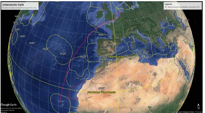
Abb. 1: Geplante Fahrtrouten und Arbeitsgebiete der MERIAN Expeditionen MSM68/2 – MSM70.
Fig. 1: Planned cruise tracks and working areas of MERIAN cruises MSM68/2 – MSM70.
- 6 -
Wissenschaftliches Programm
Scientific Programme
Fahrt / Cruise MSM68/2
Übersicht
Fahrt MSM68/2
Das Hauptziel der Expedition MSM68/2 von Emden nach Mindelo umfasst die Ermitt- lung von atmosphärischen Eigenschaften mit Fernerkundungsmessgeräten in Meeresregi- onen, in denen bodengestützte Beobachtun- gen selten durchgeführt werden können.
Neben meteorologischen Standardmessun- gen werden spezielle Geräte in Betrieb ge- nommen, um Aerosol und Wolken zu be- obachten. Darunter fallen zwei halbautoma- tisierte Wolkenkamerasysteme zur Ermitt- lung der Wolkenbedeckung, ein optisches Instrument für die Höhe der Wolkenbasis, ein Sonnenphotometer für Wasserdampf und Aerosolbelastung sowie ein Instrument für die Erfassung der vertikalen Änderung der atmosphärischen Zusammensetzung. Zusätz- lich zu den meteorologischen Messungen wird ein neues Verfahren zur Bestimmung der Alkalinität des oberflächennahen Meer- wassers getestet, das Höhenprofil des Mee- resgrunds vermessen, die vertikale Ände- rung von Meerwassertemperatur und -salzgehalt an einer Atlantikstation be- stimmt, und die Sichtung von Waltieren erfasst.
Fahrt MSM69
Entlang der mittelozeanischen Rücken wird kontinuierlich neue ozeanische Lithosphäre generiert, die ca. 57% der Erdoberfläche bedeckt. Die Krustenmächtigkeit und die Schallgeschwindigkeit in der Kruste werden durch die Schmelzgenerierung an der Rückenachse kontrolliert. Die Variabilität dieser Parameter bildet somit zeitliche Än- derungen im Spreizungsprozess ab. Nach ihrer Bildung führen hydrothermale Prozes- se über Millionen von Jahren zu Änderun- gen in der Struktur der Lithosphäre. Die Zirkulation von Seewasser durch die Kruste
Synopsis
Cruise MSM68/2
The main purpose of expedition MSM68/2 from Emden to Mindelo is to measure at- mospheric properties with remote sensing instruments in ocean regions where ground- based observations are rare. In addition to meteorological standard measurements, special instruments will be operated for ob- serving aerosol and clouds. These are semi- automated cloud imager systems for meas- uring the cloud fraction, an optical instru- ment for the cloud base height, a sun pho- tometer for the water vapour and aerosol burden as well as an instrument for the ver- tical changes in the atmospheric composi- tion. Additionally to the meteorological measurements, a new method for determin- ing the alkalinity of the near-surface sea water is tested, the orography of the sea floor is mapped, the vertical change in sea water temperature and salinity at an Atlan- tic station is determined, and sightings of cetaceans are recorded.
Cruise MSM69
The oceanic lithosphere is created by sea- floor spreading at mid-ocean ridges and covers approximately 57% of the Earth sur- face. Crustal thickness and lower crustal velocity are inherently related to the for- mation of the lithosphere and can be used to infer temporal variations in crustal accre- tion when moving away from the spreading ridge. After its formation, the shallow litho- sphere is affected by hydrothermal circula- tion in the uppermost permeable crust over tens of millions of years. In turn, heat is re- moved from the lithosphere by circulating - 7 -
führt (i) zu einer altersabhängigen Abküh- lung der Kruste und (ii) Ausfällungen hydro- thermaler Alterationsprodukte in Hohlräume erhöhen die Schallgeschwindigkeit in der Oberkruste. Als Konsequenz der Abkühlung verdickt und verdichtet sich die Lithosphäre.
Diese Änderungen spiegeln sich in der Zu- nahme der Wassertiefe, der Abnahme des Wärmestroms sowie in einer Erhöhung der seismischen Geschwindigkeit in der Mantel- Lithosphäre wider. Die Verdickung der Li- thosphäre führt dazu, dass sich die Basis der Lithosphäre von ca. 11 km (Krusten- Mantelgrenze im Bereich der Spreizungs- achse) bis in viele zehner Kilometer Tiefe verschiebt. Während die Bildungsprozesse der Lithosphäre an den Rückenachsen rela- tiv gut untersucht sind, wissen wir nur wenig darüber, wie sich der Spreizungsprozess mit der Zeit verändert hat und welchen Einfluss altersbedingte Änderungen auf die Struktur und Eigenschaften der Lithosphäre haben.
Entlang eines 1100 km langen Korridors im äquatorialen Atlantik werden während der Reise MSM69 mit geophysikalischen Me- thoden systematisch altersabhängige Ände- rungen im Wärmestrom der Krustenstruktur sowie in der Lage bedeutender Manteldis- kontinuitäten wie Moho und Basis der Li- thosphäre untersucht.
Fahrt MSM70
Ziel der BATHYCHEM-Expedition ist es, die kaum untersuchte Bathymetrists Seamount Chain sowie den Cape Verde Ridge und die Guinea Fracture Zone hochauflösend zu kartieren und umfangreich geologisch zu beproben. Die Haupt-, Spurenelement- und Isotopengeochemie von Intraplattenvulka- nismus unterscheidet sich wegen der gerin- geren Aufschmelzgrade unter dickerer Li- thosphäre stark vom Mittelozeanischen Rü- cken. Platznahme und Magmatismus von Intraplattenvulkanen beeinflusst die ozeani- sche Kruste nicht nur lokal (z.B. durch Kleintektonik und Gesteins-Schmelze- Interaktion), sondern führt auch weiträumig zu chemischen und mineralogischen Verän- derungen der Kruste durch z.B. hydrother- male Zirkulation. Die Entstehung der
seawater and mineral precipitation modifies and seals open void spaces, affecting the heat loss, seismic velocity, and composition of the crust. In addition, lithosphere cools and thickens with age, resulting in the well- known subsidence of the seafloor, decreas- ing heat flow, and increasing seismic veloci- ties in the rigid lithospheric mantle. In addi- tion, the depth to the Lithosphere- Astenosphere-Boundary (LAB) increases from approximately Moho depth to several tens of kilometres in Cretaceous crust. While the formation of crust and lithosphere at the spreading ridges is reasonably well studied, little is known about how crustal accretion changed over time and how crust and litho- sphere change when carried away from the underlying heat source. Understanding how lithosphere evolves with age is thus a major challenge in Earth sciences. During MSM69, geophysical surveys on a 580 sm long transect will be acquired in the equato- rial Atlantic using seismic refraction and heat flow methods. The goal is to collect a data set which reveals the age-dependent features of the lithospheric structure such as crustal and mantle properties, age- dependent heat flow and major lithospheric boundaries like Moho and the LAB.
Cruise MSM70
The BATHYCHEM cruise aims to undertake high-resolution mapping and dense rock sampling of the poorly investigated intraplate volcanism along the Bathymetrists Seamount Chain and its corresponding fault zones Cape Verde Ridge and Guinea Fracture Zone. Intraplate volcanism, in contrast to mid-ocean-ridge (MOR) oceanic crustal basalts, is formed by low degrees of mantle melting under thick lithosphere and, thus, has a unique and distinct major element, trace element, and isotopic composition. Magmatism associated with the emplacement of this seamount province did not only directly alter the composition of the underlying lithosphere but triggered local structural changes and fluid flow causing large-scale hydrothermal activity - 8 -
Bathymetrists Seamounts könnte demnach die Zusammensetzung weiter Teile ozeani- scher Kruste mit einer Altersspanne von 30 bis >100 Ma und unterschiedlichen Stadien der Krustenentwicklung stark beeinflusst haben. Ziel des Projektes ist es, die Struktur, das Alter und die Zusammensetzung der Bathymetrists Seamounts sowie des nahelie- genden Cape Verde Ridge und der Guinea Fracture Zone zu untersuchen, um zeitliche Variation in der Akkretion ozeanischer Kruste sowie durch Intraplattenvulkanismus hervorgerufene Veränderungen der Morpho- logie und Zusammensetzung ozeanischer Kruste besser zu verstehen.
that would have modified the original composition of the lithosphere. The formation of the Bathymetrists Seamounts may have affected the composition of oceanic crust that has a wide range of ages from 30 to >100 Ma and thus has been exposed to variable degrees of seafloor alteration during the evolution of the seafloor. This project aims at characterizing the structure, age, and composition of the Bathymetrists Seamounts and adjacent Cape Verde Ridge and Guinea Transform fault to understand their origin and formation mechanism. This will allow for better constraints how accretion of oceanic crust changes and intraplate volcanism modifies the structure and composition of oceanic lithosphere through time.
- 9 -
Von Emden / from Emden – nach Mindelo / to
Mindelo
Fahrt / Cruise MSM68/2
Wissenschaftliches Programm
Die Fahrt MSM68/2 von Deutschland zu den Kapverdischen Inseln wird hauptsächlich genutzt, um (1) detaillierte Messungen von Aerosol und Wolken vorzunehmen und (2) ein neues Messsystem für die Alkalinität von Meerwasser zu testen. Die Messungen sind wissenschaftlich wichtig, da das Netzwerk von marinen bodengebundenen Beobachtungen der At- mosphäre und des Ozeans typischer Weise dünn ist. Solche Messungen werden zum Beispiel gebraucht, um satellitengestützte Beobachtungsprodukte sowie die Leistung von Wetter- und Erdsystemmodellen zu be- werten. Die Beobachtungen unterschied- licher Disziplinen während MSM68/2 tragen dazu bei, Lücken in unserem Beobachtungs- system zu schließen. Darüber hinaus planen wir, ein Argo Float während dieser Fahrt auszulegen, um dazu beizutragen, das Netz- werk für kontinuierliche Profilmessungen des oberen Ozeans zu unterstützen.
Die Beobachtungen der Wetterstation an Bord werden durch meteorologische Ferner- kundungsinstrumente ergänzt, um die fol- genden Eigenschaften zu messen:
• Bedeckungsgrad und Basishöhe von Wolken, um Daten für eine erste schiffs- basierte Wolkentypstatistik zu sammeln, gestützt auf vertikal ausgerichtete Ka- merasysteme und einem Cilometer
• Optische Dicke und Größe von Aerosol von einem MICROTOPS Sonnenphoto- meter, einem MAX-DOAS und dem Ceilometer
• Atmosphärischer Wasserdampfgehalt vom MICROTOPS
• Regenrate und Tröpfchengrößen von einem optischen Disdrometer Ocean- RAIN ODM470
Die folgenden ozeanografischen Beob- achtungen werden durchgeführt:
Scientific Programme
The cruise MSM68/2 from Germany to Cape Verde will be primarily used (1) to take de- tailed measurements of aerosol and clouds and (2) to test a novel measurement system for seawater alkalinity. The measurements are scientifically important since the net- work of marine ground-based observations of the atmosphere and ocean is typically sparse. For instance, such observations are necessary for evaluating satellite-borne ob- servational products and the performance of weather and Earth system models. The ob- servations for different disciplines during MSM68/2 contribute to filling gaps in our observational systems. Moreover, we plan to deploy an Argo float during this cruise for contributing to the network of continuous profile measurements of the upper ocean.
In addition to the observations of the weath- er station aboard, atmospheric remote sens- ing instruments will be installed for measur- ing the following properties:
• cloud fraction and base height for col- lecting data for a first ship-based cloud type statistic, based on vertically orient- ed imager systems and a ceilometer
• aerosol optical depth and size from the sun photometer MICROTOPS, the MAX-DOAS and the Ceilometer
• atmospheric water vapour content from the MICROTOPS
• precipitation rate and droplet size spec- trum from the optical disdrometer OceanRAIN ODM470
The following oceanographic measurements will be carried out:
- 10 -
• Temperatur, Salzgehalt und Alka- linität des oberflächennahen Meer- wassers unter Verwendung einer tauchfähigen Pumpe, eines Thermo- salinographens und eines neuartigen automatisierten Filtrierungssystems
• Topography des Meeresgrundes von einem Fächerecholot
• Waltiere mit Photo-IDs und GPS Ortsangabe
• Profilmessung (Temperatur, Salz- gehalt und Druck) und Seewasser- entnahme (Gehalt von O2, Nährstoffe und CO2 ) von Wasserschöpfungen mit einer CTD-Rosette an der Kap- verdischen Ozeanbeobachtungs- station (17.6°N 24.3°W)
• temperature, salinity and alkalinity of near-surface sea water using a sub- mersible pump, a thermosalinograph and a novel automated filtration system
• sea-floor topography from an multibeam echo sounder
• cetaceans with photo IDs and GPS lo- cations
• profile measurement (temperature, sa- linity, pressure) and seawater sampling (O2, nutrients, and CO2 content) from CTD-rosette hydrocasts at the Cape Verde Ocean Observatory site (17.6°N 24.3°W)
Abb. 2: Das Arbeitsgebiet während der Expedition MSM68/2. Die pinkfarbene Linie zeigt den Fahrt verlauf. Weiterhin ist die CTD Station markiert.
Fig. 2: The working area of cruise MSM68/2. The cruise transect is shown as pink line. The CTD station is marked in the waters of Cape Verde.
Arbeitsprogramm
Unsere Arbeiten werden mit mobilen Instru- menten ausgeführt, die vor Abfahrt an Bord installiert werden und kontinuierliche Messungen während der Fahrt aufnehmen.
Work Programme
Our work will be mainly carried out with mobile instruments that are installed on the ship prior to departure and continuously operate during the cruise. In the following, - 11 -
Nachstehend wird ein Überblick zu den ge- planten Beobachtungen gegeben. Die Route der Messfahrt von Emden (Deutschland) durch die Nordsee und den Englischen Ka- nal über den Nordatlantik nach Mindelo (Kapverdische Inseln) ist in Abb. 1 schematisch dargestellt.
Wolkenbildkameras Dumbo & Pinocchio Es werden zwei Systeme mit Wolkenbildkameras des MPI-M, Dumbo und Pinocchio, betrieben, um den Verlauf des Wolkenbedeckungsgrads und –typs entlang des Schiffweges abzuleiten. Beide Systeme bestehen aus jeweils einer Kamera für den sichtbaren und den thermischen Bereich. Der Öffnungswinkel der Kameras beträgt in etwa 35 Grad und ergänzt mit der dadurch räumlich breiteren Messung die lokal beschränkte Messung der Wolken- untergrenze des Ceilometers. Es gibt mehrere Gründe für das Betreiben von zwei Kameratypen und Geräten. Beide Kamera- typen ergänzen sich, weil die Bilderfassung der thermischen Kamera während der Mittagszeit unterbrochen werden muss, um das Verschlechtern der Bilder und der Funktionalität des Instrumentendetektors durch direktes Sonnenlicht zu vermeiden.
Während dieser Zeit sind die sichtbaren Aufnahmen die einzige Messung. Diese liefern wiederum nur nützliche Informa- tionen während des Tages, sodass die Infra- rotaufnahmen die einzigen Datenquellen in der Nacht sind. Die zeitgleichen Messungen während des Morgens und am Nachmittag sind nützlich für den Vergleich und die gegenseitige Kalibrierung der Ergebnisse.
Die Dopplung der Systeme ist durch das unterschiedliche Alter und die Komplexität der Systeme begründet. Das größere und komplexere System Dumbo hat einen fort- geschritteneren Infrarotsensor, der mehr Wartungsarbeiten erfordert als das kleine, leichte und flexible System Pinocchio. Die Absicht ist, Pinocchio zukünftig auf mehre- ren Schiffen zur automatisierten Aufzeichung von Wolken einzusetzen.
Während der Expedition MSM68/2 messen wir zeitgleich mit beiden Systemen, um
an overview on the planned observations is given. The cruise track from Emden (Germany) via the North Sea and the English Channel across the North Atlantic to Mindelo (Cape Verde) is schematically depicted in Fig. 1.
Cloud imagers Dumbo & Pinocchio
The two MPI-M cloud imager systems, Dumbo and Pinocchio, are operated for deriving transects of cloud fraction and type along the ship track. Both systems consist of one mid-visible camera and one thermal camera. Their field of view is about 35 de- gree and complements with their spatially broader measurements the locally restricted cloud-base measurement of the ceilometer.
There are several reasons for the operation of two camera types and systems. Both camera types complement each other, because the thermal camera sampling needs to be intermitted around noon to avoid that direct sun-light deteriorates the thermal images and the functionality of the instrument detector. During that time the visible camera is the only measurement. The visible camera, however, is only useful during daytime such that the infrared images are the sole data source at night.
The simultaneous measurements during the morning and afternoon are useful to compare and calibrate the results to each other.
Bringing two systems is motivated by the different age and complexity of the two imager systems. The larger and more complex system Dumbo has a more advanced IR imager and needs more maintenance than the small, lightweight and flexible system Pinocchio. In the future, the intent is to deploy Pinocchios on several ships for automated operation. Onboard this cruise, we take simultaneous measurements to calibrate Pinocchio with Dumbo images, verify the functionality of Pinocchio for the - 12 -
Pinocchio- mit Dumbo-Aufzeichnungen zu kalibrieren, die Funktionsfähigkeit von Pinocchio für den automatisierten Betrieb auf Maria S. Merian zu prüfen, und die Software zur Nachbearbeitung der Messungen weiterzuentwickeln. Zusätzliche tägliche Arbeiten umfassen die Prozes- sierung und Speicherung der Bilder von Dumbo und Instandhaltearbeiten der Instru- mentenlinsen.
Ceilometer
Das Jenoptik Ceilometer des MPI-M ist ein Lasersystem, das Strahlungspulse einer Wel- lenlänge im nicht-sichtbaren nahen Infrarot (1064nm) aussendet, das nicht signifikant durch atmosphärische Spurengasabsorption beeinflusst wird. Basierend auf der Laufzeit und der Stärke des zurückgestreuten Signals, leitet das System das atmosphärische Profil von Aerosol und Wolken ab. Da das Laser- licht stark durch optisch dicke Wolken aus- gelöscht wird, gibt es typischer Weise keine Information oberhalb der Wolkenuntergren- ze, die Daten vor allem für die Bestimmung der Basishöhe und der Häufigkeit von Wolken dient. In wolkenfreien Bedingungen und unterhalb von Wolken kann das Profil der Aerosolrückstreuung gemessen werden, das die Höhe der Grenzschicht anzeigt, vor allem, wenn große Aerosolpartikel wie Mineralstaub vorhanden sind. Messungen unterhalb von 500m sind wegen der Instrumenteneigenschaften nicht nützlich, werden aber durch MAX-DOAS und MICROTOPS Messungen ergänzt.
MICROTOPS Sonnenphotometer
Das tragbare Sonnenphotometer MICRO- TOPS misst die Abschwächung der direkten Sonnenstrahlung während wolkenfreier Be- dingungen. Diese erlauben es, Informationen zur aerosol optischen Dicke, der Aero- solgröße und dem Wasserdampfgehalt des Atmosphärenpfades zwischen dem Beob- achter und der Sonne abzuleiten. Das Instru- ment misst die Intensität der Sonnenstrah- lung für fünf Wellenlängen (380, 440, 670, 870 und 940nm). Die einfallende Sonnen- strahlung an der Obergrenze der Atmosphä- re wird intern aus Ort und Zeit der gleichzei-
automated operation on Maria S. Merian, and continue the development of the post- processing software. Additional daily work includes the processing and saving of images produced by Dumbo and maintenance work on all instrument lenses.
Ceilometer
The Jenoptik Ceilometer of the MPI-M is a laser system that vertically emits radiation pulses at a non-visible near-infrared wave- length (1064nm), which is not influenced by significant atmospheric trace-gas absorp- tion. Based on the time-delay and strength of the backscattered signal the instrument de- rives an atmospheric profile of aerosol and clouds. Since the laser light is strongly at- tenuated in optically thicker clouds, usually no information is retrieved above the cloud base such that the data is primarily useful for information on the cloud base height and frequency of cloud passage. In cloud-free conditions and below clouds, the aerosol backscatter profile is measured that might indicate the boundary layer depth, primarily in the presence of aerosol species of large size like mineral dust. The measurements below 500m are not useful due to the in- strument characteristics, but will be com- plemented by MAX-DOAS and MI- CROTOPS measurements.
MICROTOPS sun photometer
The hand-held MICROTOPS sun photome- ter measures the direct solar attenuation during cloud-free conditions. These allow deriving information on the aerosol optical depth, aerosol size and water vapour con- tent for the atmospheric path between ob- server and the sun. The instrument measures the solar intensity for five wavelengths (380, 440, 670, 870 and 940nm). The top of the atmosphere incoming solar radiation is in- ternally calculated from the location and time of the simultaneously operating GPS unit. The difference of the incoming solar - 13 -
tig messenden GPS Einheit bestimmt. Der Unterschied zwischen der einfallenden Son- nenstrahlung und der Messung an Bord (Un- tergrenze der Atmosphäre) bestimmt die atmosphärische Abschwächung der Sonnen- strahlung. Da die Abschwächung sowohl durch Aerosol als auch durch Spurengase zustande kommt, werden solche Messungen in Wellenlängen, die wenig durch Spurenga- se beeinflusst werden (380, 440, 670 und 870nm), für die Ableitung der aerosol opti- schen Dicke (AOD) verwendet. Die AOD für unterschiedliche Wellenlängen werden benutzt, um den Angstrom Parameter im Nachgang zu berechnen, dessen Wert ein Indikator für die Aerosolgröße ist. Zusätz- lich zum Aerosol, wird der atmosphärische Wasserdampfgehalt bestimmt, indem die Messungen bei 940nm mit einer starken Wasserdampfabsorption mit jenen bei 870nm ohne Wasserdampfabsorption ver- wendet werden. Ein Wissenschaftler an Bord, der das Instrument auf die Sonne aus- richtet, führt die MICROTOPS Messungen manuell durch. Die Daten werden täglich ausgelesen und an die NASA geschickt. Die auf Qualität geprüften Ergebnisse stehen nach kurzer Zeit im „Marine Aerosol Net- work“ zur Verfügung.
MAX-DOAS Messungen
Multi-Axis-DOAS-Instrumente messen ge- streutes Sonnenlicht unter verschiedenen (hauptsächlich sehr flachen) Elevatons- winkeln. Aus den gemessenen Spektren kön- nen Höhenprofile verschiedener atmosphäri- scher Spurengase (z.B. NO2, HCHO, CHOCHO, O4, SO2, BrO, IO) und Aerosol- extinktionsprofile in den unteren 2 – 3km der Atmosphäre abgeleitet werden. MAX- DOAS-Messungen sind am empfindlichsten für die direkt über dem Boden gelegene at- mosphärische Schicht. Dort können die at- mosphärischen Lichtwege bis zu 20 km lang werden. Die Zeitauflösung für eine Eleva- tionssequenz ist etwa 15 Minuten. Das Ziel während dieser Expedition ist die Gewin- nung und Interpretation von Aerosol-Extink- tionsprofilen, die aus den Messungen des Sauerstoff-Dimers (O4) abgeleitet werden.
Die erhaltenen Aerosolprofile haben eine
radiation to the onboard measurements (at the bottom of the atmosphere) determines the atmospheric attenuation of the solar radiation. Since the attenuation can be caused by aerosol and trace-gases, those measurements in wavelengths that are weak- ly affected by trace gases (380, 440, 670 and 870nm) are used to derive the aerosol opti- cal depth (AOD). The AOD at different wavelengths are used to post-process the Angstrom parameter, the value of which is an indicator for the aerosol size. In addition to aerosol, the atmospheric water vapour content is determined by using the meas- urement at 940nm with strong water vapour absorption, and at 870nm without water vapour absorption. A scientist aboard who points the instrument directly to the sun manually carries out the measurements.
Data are retrieved and send to NASA on a daily basis. The quality controlled results are accessible via the Marine Aerosol Network shortly thereafter.
MAX-DOAS measurements
Multi-Axis-DOAS instruments observe scat- tered sunlight at different (mainly very slant) elevation angles. From these measurements height profiles of atmospheric trace gases (e.g. NO2, HCHO, CHOCHO, O4, SO2, BrO, IO) and aerosol extinction in the lowest 2 – 3 km of the atmosphere can be derived.
MAX-DOAS measurements have the highest sensitivity close to the ground, where the atmospheric light paths can become very long, up to 20 km. The time resolution for one elevation sequence is about 15 minutes.
The aim of the MAX-DOAS measurements during this expedition is the retrieval of aer- osol extinction profiles, which is based on the measurement of the oxygen dimer (O4).
The derived aerosol extinction profiles have a rather coarse vertical resolution (with about 2 to 3 independent pieces of infor- mation), but are most accurate close to the - 14 -
recht grobe Auflösung mit nur etwa 2 – 3 unabhängigen Datenpunkten in verschie- denen Profilhöhen. Andererseits haben sie die größte Genauigkeit direkt über dem Bo- den, wo LIDAR-Messungen typischerweise
‚blind’ sind. Die aus den MAX-DOAS-Mes- sungen erhaltenen Profile werden mit den simultanen Messungen mit dem Sonnen- photometer verglichen und nach Möglich- keit kombiniert. Die resultierenden Aerosol- profile werden zur Validierung von Satel- litenmessungen verwendet. Neben den Aerosolmessungen werden aus den MAX- DOAS-Messungen auch Spurenstoffprofile (insbesondere von BrO, IO, CHOCHO und HCHO) ausgewertet.
Ozeanografische Messungen
Es wird eine ausführliche Felderprobung eines neuen Instruments zur autonomen Durchflussmessung der Alkalinität von Meerwasser durchgeführt – das HydroFIA TA System (KM Contros GmbH). Es ist vorgesehen, das Messgerät auf dem vom GEOMAR betriebenen
“Voluntary Observing Ship” (VOS) M/V Atlantic Sail zu installieren, das Kohlen- stoffmessungen im Oberflächenwasser auf einer Nordatlantikroute zwischen Europa und Nordamerika durchführt. Die Teil- nahme an der MSM68/2 Expedition stellt den letzten großen Feldtest vor diesem Betrieb dar. Dabei ist es von großer Be- deutung, das Verhalten des Systems unter kontinuierlichen Messbedingungen zu analysieren, so zum Beispiel im Hinblick auf Reproduzierbarkeit, Richtigkeit und Stabilität der Messungen. Für die Ermitt- lung der Richtigkeit werden sowohl regel- mäßig zertifizierte Referenzmaterialien vermessen als auch Seewasserproben für die Analyse im GEOMAR entnommen.
Darüber hinaus werden wir eine CTD- Beprobung an der Zeitserienstation
„Cape Verde Ocean Observatory“ durch- führen und ein ARGO Float wird aus- gelegt.
Beobachtung von Waltieren
Makronesien gilt als eines der besten Gebiete für die Beobachtung von Waltieren
surface, where LIDARs are typically blind.
The retrieved profiles will be compared (and possibly combined) with the simultaneous sun photometer observations. The results will be used to validate satellite observa- tions of aerosol properties over ocean. Be- sides the aerosol profiles, also some trace gases (in particular BrO, IO, CHOCHO and HCHO) will be analysed from the measured MAX-DOAS spectra.
Oceanographic measurements
A full sea trial of a novel instrument for the autonomous flow-through measurement of seawater alkalinity – the HydroFIA TA system (KM Contros GmbH). It is scheduled for installation on the “Voluntary Observing Ship” (VOS) M/V Atlantic Sail for surface ocean carbon observation operated by GEOMAR between Europe and North America. The field trials on the MSM68/2 cruise are the final tests prior to the VOS operation. It is of high importance to fully understand the behavior of the system under continuous operational use, for example to test the reproducibility, accuracy and stability of the measurements. To assess the measurements, we will routinely analyze certified reference material during the cruise and take seawater samples for shore-based analysis with reference systems.
Additionally, a CTD hydrocast will be carried out at the time-series station “Cape Verde Ocean Observatory”, and an ARGO float will be deployed.
Cetacean observation
The Macaronesian area is considered one of best hot spots for cetacean observation in - 15 -
weltweit, das 30 Spezies beherbergt und regelmäßig beobachten lässt. Es ist somit ein idealer Ort zur Forschung, Erhaltung und Bewusstseinsbildung in der Öffentlichkeit für diese Tiere. Somit hat das Projekt MARCET das Ziel, ein multidisziplinäres Netzwerk von Wissens- und Technologie- transfer in Makronesien zu bilden, um zum einen Waltiere und deren Habitat zu schüt- zen, zu überwachen und zu kontrollieren, und zum anderen die damit verbundenen touristischen Aktivitäten auf eine nachhal- tige Art zu entwickeln. In diesem Zusammenhang dient die Expedition dazu, ozeanographische Daten für die Charakteri- sierung des makronesischen Habitats zu ge- winnen und nach Möglichkeit grundlegende Informationen zu Waltierbeständen entlang des Weges zu sammeln. Darüber hinaus werden Daten erhoben, z.B., geographische Position, Spezies, Photoidentifikation, An- zahl der Tiere, Gruppenstruktur und deren Verhalten, und mit den Forschungsgruppen auf Madeira, den Kanarischen Inseln, den Azoren und den Kapverdischen Inseln geteilt, um die Aufzeichnungen und das Wissen über solche Spezies durch Ver- gleiche der Photo-ID Kataloge und Bewe- gungen in Makronesien zu erweitern.
the world, having more than 30 species that can be seen regularly. It is an ideal place for research, conservation and public aware- ness of these animals. As such, the project MARCET (INTERREG V, MAC 2014-2020, MAC/1.1b/149) aims to create a Macaro- nesian multidisciplinary network of knowledge and technology transference for the protection, vigilance and monitoring of cetaceans and their habitat, as well as ana- lyse and develop the touristic activities as- sociated with it in a sustainable way. In this context this trip will serve to obtain oceano- graphic data that will contribute to the characterization of the Macaronesian ceta- cean habitat, as well as to serve as an op- portunistic platform for the basic infor- mation on the cetacean populations encoun- tered along the way. Moreover, data such as geographic location, species, photo- identification, number of animals, group structure and behavioural context will be collect whenever possible, shared with the research groups in Madeira, Canary, Azores and Cape Verde archipelagos to enrich their databases and contribute to the increment of knowledge of such species by comparing photo-ID catalogues and movements in the Macaronesian area
- 16 -
Zeitplan / Schedule Fahrt / Cruise MSM68/2
Tage/days Auslaufen von Emden (Deutschland) am 04.11.2017
Departure from Emden (Germany) 04.11.2017
Transit zum Arbeitsgebiet / Transit to working area 0,5
Kontinuierliche Messungen 8
Continuous measurements
Vertikalprofile von der CTD-Rosette 0,5
Vertical profile from the CTD-Rosette
Auslegen eines ARGO floats 0,5
Deployment of an ARGO float
Transit zum Hafen Mindelo 0,5
Transit to port Mindelo
Total 10 Einlaufen in Mindelo (Kapverdische Inseln) am 14.11.2017
Arrival in Mindelo (Cape Verde) 14.11.2017
- 17 -
Von / From Mindelo Nach / To Mindelo
Fahrt / Cruise MSM69
Wissenschaftliches Programm
Selbst nach vielen Jahren intensiver Erforschung der Ozeane ist unser Wissen über die unterhalb des Meeresbodens lie- gende ozeanische Lithosphäre und ihre phy- sikalischen Eigenschaften noch immer sehr limitiert und basiert primär auf den Erkenntnissen von mittelozeanischen Rü- cken oder auf globalen Datensätzen, wie seismologische Erkenntnisse über die Struktur der Erde, welche unterhalb der Ozeane ein sehr geringe Auflösung haben.
Darüber hinaus geben Kompilationen von sporadischen Schiffsmessungen Aufschluss über die Meerestiefe oder den Wärmeverlust der Erde. Wenig ist jedoch über lokale und regionale Variationen bekannt.
Die Arbeiten im Rahmen von LITHOS haben das Ziel, altersabhängige Eigen- schaften in der Struktur und dem physikalischen Zustand der Lithosphäre als Funktion des Krustenalters abzubilden. Ziele sind:
1.) Charakterisierung der Variabilität der Struktur ozeanischer Kruste (Mächtigkeit und seismische Geschwindigkeit) als Funktion der Zeit (d.h., Entfernung zur Spreizungsachse).
Nahezu alle Prozesse sind natürlichen Schwankungen unterworfen, so auch die Bildung neuen Meeresbodens. Mächtigkeits- variationen und Änderungen in der seis- mischen Geschwindigkeit in der ozea- nischen Kruste können als Proxy für Schmelzprozesse und Änderungen in der Manteltemperatur dienen.
2. Charakterisierung atlantischer Kruste Seit der Öffnung des Atlantiks wird neue Kruste bei langsamen Spreizungsraten erzeugt. Die Struktur atlantischer Kruste wird oft als Referenz für andere Regionen genutzt. Unsere Referenzstruktur basiert je-
Scientific Programme
Even today, little is known about the struc- ture of the lithosphere and its properties are basically deduced from the structure found at mid-ocean ridges and from seismological studies based on seismometers deployed mainly in the continents. Further, global datasets of bathymetry and heat flow are used to assess its thermal properties. How- ever, those did not account for local and regional features that might be important in governing lithospheric properties.
During the LITHOS survey we are going to image changes of the physical properties of the lithosphere as a function of lithospheric age, studying oceanic lithosphere as it ma- tures with time and hence distance from the spreading ridge. Goals are:
1. Mapping variations in the accretionary process over millions of years, revealed by crustal thickness and seismic velocities.
The oceanic lithosphere is created by sea- floor spreading at mid-ocean ridges. How- ever, periodicities in the accretion may af- fect lithospheric formation. Variations of melt generation and mantle temperature will affect crustal formation, which will in turn affect crustal thickness and crustal velocity structure. Crustal thickness and seismic ve- locity are therefore proxies to assess perio- dicities in crustal accretion over time.
2. Characterization of Atlantic-type litho- sphere
Crustal structure of slow spreading ridges or Atlantic-type crust has been used for many years as reference for studies of vari- ous processes, including studies of mid- - 18 -
doch auf knapp 30 Jahre alten Daten, welche vor allem in der Nähe der Ostküste von Nord-Amerika aufgenommen wurden. Im Rahmen unserer Arbeiten wollen wir un- tersuchen, inwieweit diese Referenz noch zeitgemäß ist.
3. Oberkrustengeschwindigkeit als Funktion des Krustenalters und der hydrothermalen Aktivität
Seit vielen Jahren ist bekannt, dass hy- drothermale Prozesse die Struktur der Ober- kruste mit der Zeit verändern. D.h., hydro- thermale Ausfällungen verschließen Hohl- räume in der Kruste und erhöhen somit die seismische Geschwindigkeit. Eine Reduzie- rung der hydrothermalen Zirkulation redu- ziert den Wärmeverlust, sodass Änderungen der seismischen Geschwindigkeitsstruktur in der Oberkruste mit dem Wärmeverlust korrelieren.
4. Übergang von hydrothermaler Aktivität zu Wärmeleitung
Hydrothermale Prozesse bedingen i. allg.
einen zusätzlichen Wärmeverlust, sodass der beobachtete Wärmestrom geringer ist als der zu erwartende Wert einer rein konduktiv abkühlenden Lithosphäre. Global findet der Übergang zwischen beiden Systemen in ca.
50-60 Mio. Jahre alter Kruste statt. Gilt das auch für den äquatorialen Atlantik?
5. Änderungen in der Struktur des Oberen Mantels als Funktion der Zeit. Ist der Mantel geschichtet?
Seismische Messungen zeigen, dass die Schallgeschwindigkeit im lithospherischen Erdmantel im Bereich ozeanischer Rücken mit <7.6 km/s generell sehr viel langsamer ist als in alter Lithosphäre mit >8.1 km/s.
Der Übergang von langsamem zu schnellem (normalem) Mantel konnte bislang noch nicht „in situ“ beobachtet werden, sodass die Ursachen noch relativ unverstanden sind.
Darüber hinaus zeigten Untersuchungen aus den 1970er und 1980er Jahren keinen homogenen sondern einen geschichteten Mantel.
6. Abbildung der Grenze zwischen Lithosphäre und Asthenosphäre (LAB) mittels Weitwinkelseismik.
In kontinentalen Regionen konnte die LAB
ocean ridges and continental margins. How- ever, the reference structure is based on data acquired before 1990, with the majority of data from the Western Atlantic off the US East coast. We therefore aim to survey and update the reference structure.
3. Revealing upper crustal velocity structure as a function of plate age and relating changes to the hydrogeological regime as expressed by heat flow data.
It is well known that upper crustal velocities increase with age and are controlled by hy- drothermal precipitation of alteration prod- ucts into open pore spaces of the extrusive crust. We like to survey the relationship be- tween changes of the seismic properties of the upper crust and the sealing age (hydro- thermal mining of heat). Thus, are changes of layer 2 seismic velocity indeed related to the sealing age or does the velocity satu- rates (remains constant) at younger ages?
4. When does hydrothermal circulation cease in the Central Atlantic Ocean?
Hydrothermal circulation is called ceased when the observed heat flow approaches the conductive heat flux. Globally it occurs on seafloor roughly 50-60 Ma old. However, do we observe the same trend or does sealing occurs earlier or later?
5. How does the upper mantle change with age? Is the mantle layered?
We know very little about the lithospheric mantle structure in the oceans. We know that seismic velocities are generally <7.6 km/s at zero-age and in the vicinity of MORs, while normal mantle has velocities of >8.1 km/s. However, how do velocities change with age? How important is serpen- tinization for producing reduced velocities in oceanic mantle? Is the mantle indeed lay- ered as indicated in studies conducted in the 1970s and 1980s?
6. Imaging the LAB (Lithosphere Astheno- sphere Boundary) using seismic refraction and wide-angle data.
In continental settings the LAB has been - 19 -
durch energiereiche Explosionen seismisch abgebildet werden. Luftpulser erreichen im Vergleich dazu eine geringere Signalstärke.
Trotzdem kann die sehr viel höhere Schussdichte (z.B. durch Stapeln) sowie die hohe Dynamik moderner Seismometer die geringere Quellstärke mariner Quellen kom- pensieren, sodass man davon ausgehen kann, bis in ca. 50 km Tiefe seismische Dis- kontinuitäten abbilden zu können. D.h., in ca. 5-40 Mio. Jahre alter junger ozeanischer Lithosphäre könnte es möglich sein, die LAB seismisch abzubilden.
7. Zusammenschau von refraktions- und iLAB reflexionsseismischen Daten
Im Jahre 2015 wurden Teile unseres seismischen Profils mittels Mehr-Kanal- Reflexionsseismik (MCS) abgebildet. Die MCS-Daten haben einen Industriestandard (Streamer: 4-Comp., 12 km Länge).
Geschwindigkeitsanalysen der Refraktions- und Weitwinkelseismik und Analysen der MCS-Seismik werden sich gegenseitig befruchten. Die reflexionsseismischen Daten werden z.Zt. im Rahmen des Vorhabens iLAB durch die Projektpartner des IPGP (Paris) prozessiert.
imaged using seismic refraction and seismo- logical data. Large airgun arrays may not reach the same peak pressure as explosives commonly used for long-range soundings of the continents. However, a dense shot spac- ing (allowing stacking) and the high dynam- ic range of modern receivers should com- pensate the source effects. Thus, using mod- ern recording systems and large volume airgun arrays we should be able to image the ocean lithosphere down to 50 km, per- haps down to 80 km. In lithosphere of 5 to
~40 Ma we should be able to sample the LAB as it will be within ~5 to 50 km below Moho. It would be the first marine survey ever conducted to image the LAB from the ridge flank into an ocean basin.
7. Nurturing coincident iLAB reflection seismic data
The cruise MSM69 is closely related to an industry-type multi-channel-seismic (MCS) reflection survey (called iLAB) collected in 2015 along the transect using a 4- component 12-km long seismic streamer.
The velocity model derived from the refrac- tion data will be used for imaging and mi- gration of the MCS data. MCS data are pro- cessed by the IPGP partner.
- 20 -
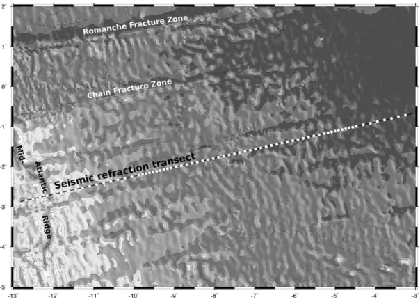
Abb. 3: Die geplante 1100 km lange seismische Auslage (Kreise: Ozean-Boden-Seismometer).
Fig. 3: Planned 580 sm long seismic transect (dots: ocean-bottom-seismometers).
Arbeitsprogramm
Die Ziele der Expedition sollen durch ein 1100 km langes seismisches Profil erreicht werden, welches von der Rückenachse des Mittel-Atlantischen Rückens (MAR) bis in 50 Mio. Jahre alte afrikanische Lithosphäre reicht. Um die Rückenachse zu unterschie- ßen, liegt das westliche Ende des Profils ca.
~100 km westlich des MAR. Insgesamt sol- len 60-70 Ozean-Boden-Seismometer (OBS) und Hydrophone (OBH) in einem Abstand von 10-20 km ausgelegt werden. Um Stör- signale zu minimieren und somit die Signal- qualität zu erhöhen, werden die Schüsse der 12 Luftpulser mit einem Gesamtvolumen von 82-Litern nur alle 3-4 Minuten abgege- ben (Schussabstand ~350 m). Des Weiteren wird sowohl der Wärmestrom gemessen als auch bathymetrische Daten gesammelt.
Die Länge der seismischen Linie erklärt sich durch eine Zahl an Rahmenbedingungen:
(i) hydrothermale Aktivität beeinflusst den Wärmetransport über mehrere Mio. von Jah- ren. Aus diesem Grund muss der Wärme-
Work Programme
Our goals can be reached conducting a sin- gle seismic refraction and wide-angle pro- file shot from the median valley of the Mid- Atlantic Ridge (MAR), extending from juve- nile lithosphere into a 50 Ma old African plate. To undershoot the MAR, the profile extends ~100 km onto the American plate. In the equatorial Atlantic such a profile will be 1100 km long (Figure 3). 60-70 Ocean- Bottom-Seismometers (OBS) and hydro- phones (OBH) will be spaced at 10-20 km intervals and shots will be fired in a noise reduced mode and hence every 3-4 min (~350 m intervals) using a 5125 cubic-inch tuned airgun array. Along the same corridor heat flow data and seafloor bathymetry will be collected.
The length of the profile is defined by a number of features:
(i) hydrothermal circulation may control oceanic heat flux for tens of millions of years after lithospheric formation. To char- - 21 -
strom sowohl in sehr junger als auch in alter Lithosphäre bestimmt werden. Um die Kopplung zwischen hydrothermaler Präzipi- tation und seismischer Geschwindigkeit zu evaluieren, müssen seismische Daten und Wärmestromanomalien entlang des gleichen Profils vermessen werden.
(ii) Frühere Untersuchungen im Atlantik zeigten eine erhebliche Variabilität der Kruste. Lassen sich entsprechende Hinweise in der Lithosphäre finden, die in den letzten 50 Mio. Jahren gebildet wurde?
(iii) Noch immer ist die Struktur der Mantel- Lithosphäre unter den Ozeanbecken relativ wenig untersucht und verstanden. Eine Ab- bildung der Geschwindigkeitsstruktur, mög- licherweise bis zur Lithosphären- Asthenosphären Grenze (LAB) verlangt lange Auslagen in refraktionsseismischen Messungen. Einige jüngere Untersuchungen ergaben Reichweiten von >400 km und so- mit Eindringtiefen von einigen Zehner Ki- lometern.
(iv) Das seismische Profil und die Wär- mestrommessungen sollen ortsgleich mit existierenden reflexionsseismischen Daten des IPGP gesammelt werden, sodass alle Datensätze sich gegenseitig befruchten kön- nen.
acterize hydrothermal activity as a function of age, we need a wide range of crustal ages covering juvenile and mature lithosphere.
Further, to survey the relationship between changing seismic properties by hydrother- mal precipitation both heat flow and the seismic structure have to be sampled along the same profile.
(ii) Crustal structure in the Atlantic Ocean has been reported being highly variable along flow lines, reflecting periodicities of emplacement. Crustal thickness and seismic velocities are proxies to assess such perio- dicities. A profile covering approx. 50 Ma of seafloor spreading history will nurture our understanding of crustal production rate as a function of time, covering about 50% of the time since break-up.
(iii) The mantle structure under the oceans is still poorly imaged and understood. To image the mantle – perhaps down to the LAB – requires long-range seismic profiles.
Recent experiments successfully recorded shots at >400 km airgun-receiver offsets.
(iv) The seismic refraction and wide-angle survey and the heat flow work will be con- ducted long an existing MCS currently pro- cessed at IPGP so that all datasets comple- ment each other.
- 22 -
Zeitplan / Schedule Fahrt / Cruise MSM69
Tage/days
Auslaufen von Mindelo (Kapverden) am 14.11.2017 6
Departure from Mildelo (Cape Verdes) 14.11.2017
Auslegung von Ozean-Boden Seismometern-(OBS) 3
Deployment of ocean-bottom-seismometers (OBS)
Luftpulser 8
Airgun shooting
Wiederaufnahme von Ozean-Boden Seismometern-(OBS)
Recovery of ocean-bottom-seismometers 10
Wärmestrommessung 5
Heat flow measurements
Transit zum Hafen Mindelo 5
Transit to port Mindelo
Total 37 Einlaufen in Mindelo (Kapverden) am 22.12.2017
Arrival in Mindelo (Cape Verdes) 22.12.2017
- 23 -
Von / From Mindelo Nach / To Las Palmas
Fahrt / Cruise MSM70
Wissenschaftliches Programm
Ziel des BATHYCHEM Projektes ist die Kar- tierung und Untersuchung der Entstehung und des Alters der Bathymetrists Seamounts, des Kap Verde Rückens sowie der westl.
Guinea Fracture Zone (inkl. der westlichen Grimaldi Seamounts).
Ein Hauptaspekt des Projektes ist die Unter- suchung des Intraplattenvulkanismus der Bathymetrists Seamounts über eine weite Spanne von ozeanischen Krustenaltern (<30 bis >100 Mio Jahre). Wir erwarten Erkennt- nisse darüber, wie Intraplattenvulkanismus die ozeanische Lithosphere geochemisch und geomorphologisch verändert.
Um die Fragestellungen zu beantworten planen wir ein umfangreiches Kartier- und Probennahmeprogramm auf See, gefolgt von detaillierten geochemischen Untersuchungen in den Heimatlaboren. Dieses wenig unter- suchte vulkanische Gebiet wird studiert, um z.B. zu klären, ob es sich um Plume- Vulkanismus mit tiefen Wurzeln im Erd- mantel oder flachere asthenosphärische Schmelzen handelt und welche Rolle das komplexe lokale Muster von Transformstö- rungen bei der Entstehung der Vulkane spielte.
Bathymetrische Karten sollen dabei helfen, die tektonischen Wechselwirkungen beim Aufeinandertreffen von Kap Verde Rücken, Guinea Fracture Zone und der nördlichsten Bathymetrists- und westlichen Grimaldi Seamounts zu untersuchen. Hochauflösende Meeresbodenkarten sollen Informationen zur Morphologie und Beschaffenheit des Meeresbodens liefern und können Hinweise auf möglicherweise jüngere vulkanische Aktivität liefern. Die Auswertung der geo- morphologischen Daten kann dabei helfen, die Platznahme von Intraplattenvulkanen zu untersuchen sowie deren Einfluss auf die
Scientific Programme
Main goal of the BATHYCHEM project is to gain more in-depth insights into the origins and ages of the Bathymetrists Seamounts, the Cape Verde Ridge Fault, and the west- ern Guinea FZ by generating high- resolution bathymetric maps and by sam- pling the Cape Verde Ridge FZ and the Guinea FZ (incl. the western Grimaldi Sea- mounts.)
The project also aims at characterizing the age and composition of intraplate volcanism on the seafloor ranging from <30 to >100 Ma in age. This will allow for better con- straints on how intraplate volcanism modi- fies the composition and geomorphology of oceanic lithosphere through time.
We plan an extensive mapping and dredge program to sample these seafloor structures.
This will be followed by petrological, geo- chemical and geochronological analyses aiming at deciphering the origin of this sparsely studied volcanic province, and to determine if the Bathymetrists and Grimaldi Seamounts were formed from either a deep plume source or shallower asthenosphere melting. Furthermore, we will look at the role of local transform faults intersecting the seamount province.
Bathymetric maps will help to understand the tectonic interplay at the junction of the Cape Verde Ridge FZ, the Guinea FZ as well as the northern part of the Bathymet- rists Seamounts and western part of the Grimaldi Seamounts. We aim to map the area at high resolution to answer questions about seafloor characteristics and possibly identify areas with young (recent) volcan- ism. Morphological and tectonic studies on bathymetric data will improve the knowledge of emplacement of intraplate volcanoes and their effects on the surround- ing plate, especially in this highly active - 24 -
umliegende ozeanische Kruste, speziell in dem tektonisch sehr aktiven Arbeitsgebiet.
Petrologie, Mineralogie, Haupt- und Spu- renelementchemie sowie (Sr-Nd-Pb-Hf-O) Isotopengeochemie wird an den geborgenen Gesteinsproben nach der Expedition in den Heimatlaboren untersucht. Diese Daten werden für die folgenden Fragestellungen benötigt:
1) Welche Prozesse beeinflussen die Krus- tenakkretion am Mittelozeanischen Rücken?
Wie variierten Manteltemperaturen, Zu- sammensetzung und Spreizungsraten zeit- lich und wie hängen diese mit der Krusten- dicke und jüngerem Vulkanismus zusam- men.
2) Gibt es Hinweise auf Veränderungen in der Zusammensetzung des oberen Erdman- tels über lange Zeiträume (z.B. die Lebens- spanne eines ganzen Ozeanbeckens). Gab es z.B. eine stärkere kontinentale oder Plume- Komponente in frühen atlantischen Basalten nach dem Aufbrechen der kontinentalen Kruste als in modernen mittelozeanischen Basalten?
3) Was ist das Alter und die Magmenquelle der Grimaldi und Bathymetrists Seamount Ketten? Wie beeinflusst Intraplattenvulka- nisus großräumig die Zusammensetzung der umliegenden ozeanischen Kruste unter- schiedlichen Alters?
Die Altersbestimmung der Seamounts und Kruste soll mittels 40Ar/39Ar und U/Pb Zir- kon Datierung durchgeführt werden. Dabei soll versucht werden, die nötigen Analysen auf gut erhaltene K-reiche Minerale zu kon- zentrieren. Dies würde eine präzisere Datie- rung erlauben als es die wenigen bisherigen geochronologischen Studien taten, welche die alterierte Grundmasse der Gesteine da- tierten.
tectonic environment.
Petrology, mineralogy, major and trace el- ement and isotope (Sr-Nd-Pb-Hf-O) geo- chemistry will be carried out on the recov- ered rock samples after the expedition.
These data will be used to address the fol- lowing scientific questions and hypotheses:
1) What processes affect crustal accretion at mid-ocean ridges over time? How have mantle temperature, composition and spreading (as well as upwelling) rate of the Central Atlantic spreading center varied and how do these parameters relate to crus- tal thickness and younger volcanism?
2) What is the age and the source of the Grimaldi and Bathymetrists Seamount chain and how is large-scale intraplate volcanism affecting the geochemical budget of oceanic lithosphere of different ages?
3) Is there evidence for systematic, long- term (over the life span of the Atlantic Ocean basin) changes in the composition of the upper mantle source, e.g., was more continental or plume material present in the MORB source during the early stages of ocean basin formation just after continental breakup than in younger ocean crust and present-day MORB
We also plan to determine the ages of both ocean crust and Bathymetrists and Grimaldi seamount samples using 40Ar/39Ar and U/Pb zircon dating techniques in order to under- stand their formation mechanisms in time.
We aim to concentrate on 40Ar/39Ar dating of preserved multi-phase K-rich minerals in these samples. This should provide us with accurate 40Ar/39Ar dating and is in contrasts with the very few previous geochronological studies in the working area that dated the altered groundmass.
- 25 -
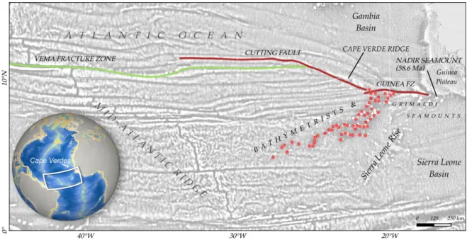
Abb. 4: Das Arbeitsgebiet der Expedition MSM70 liegt im östlichen Zentralatlantik vor Westafrika. Die Cape Verde Ridge Störung, die Guinea Fracture Zone sowie die westl. Grimaldi Seamounts und nördli- chen Bathy metrists Seamounts werden kartiert und geologisch beprobt.
Fig. 4: The working area of cruise MSM70 in the Eastern Central Atlantic. The Cape Verde Ridge fault, the Guinea Fracture Zone as well as the western Grimaldi seamounts and northern Bathymetrists Sea- mounts will be mapped and sampled.
Arbeitsprogramm
Um die wissenschaftlichen Ziele zu errei- chen, sollen Gesteinsproben entlang des Kap Verde Rückens, der westlichen Guinea Frac- ture Zone sowie der Bathymetrists und west- lichen Grimaldi Seamounts genommen wer- den.
Da das Gebiet weitgehend unkartiert ist, wird die Gesteinsprobennahme von einer umfangreichen Fächerecholotkartierung begleitet, um bathymetrische Karten als Grundlage für alle weiteren Arbeiten bereit- zustellen.
Die Meeresbodenkartierung wird mit dem schiffseigenen EM122 Tiefseefächerlot der Firma Kongsberg Maritime AS durchge- führt. Dieses System kann effektiv im Ar- beitsgebiet eingesetzt werden und im soge- nannten Dual-Ping Modus auch bei höheren Vermessungsgeschwindigkeiten sehr gute Ergebnisse liefern.
WorkProgramme
Sampling by dredging will be conducted mainly along the Cape Verde Ridge, the western Guinea FZ as well as the Bathymet- rists and western Grimaldi Seamounts.
Since all target areas are mainly unmapped, we will combine hard rock sampling with high resolution multibeam surveys for the definition of dredge targets and to obtain a bathymetric map for tectonic and structural analysis of the area.
The multibeam mapping will be carried out with the hull mounted EM122 deep water multibeam echo sounder system provided by Kongsberg Maritime AS. With this system, we can effectively map the working areas and, due to the so-called dual-ping mode, will do so even at higher cruising speeds with still very good results.
- 26 -
Die Meeresbodenkartierung geschieht in Echtzeit, wodurch eine schnelle Identi- fikation von geeigneten Zielen für die Gesteinsprobennahme möglich ist.
Die Gesteinsprobennahme geschieht mittels geologischer Kettensackdredgen - eine erfolgreiche, effektive kosten- und zeitschonende Methode, um vulkanische Gesteinsproben aus unterschiedlichen Wassertiefen zu bergen.
Wir planen, die Flanken der Störungen entlang des Kap Verde Rückens und der westlichen Guinea Fracture Zone (inkl. der westlichen Grimaldi Seamounts) sowie der Bathymetrists Seamounts mit bis zu 65 Dredgezügen zu beproben: 15 Stationen entlang des Kap Verde Rückens und angrenzender Störungen (Arbeitsgebiet 1);
20 Stationen sind im Arbeitsgebiet 2 geplant (westl. Guinea Fracture Zone, westl.
Grimaldi sowie nördlichste Bathymetrists Seamounts). Für die Arbeitsgebiete 3 und 4 sind bis zu 30 Stationen entlang der Bathymetrists Seamounts geplant.
Swath mapping of seafloor morphology and seafloor properties is done in real-time ena- bling a very good identification of dredge targets within shortest time.
The hard rock sampling will be carried out using heavy chain bag dredges being a high- ly successful and efficient (relatively low cost and little time-consuming) method for sampling igneous rocks from the seafloor of various depths and age.
We plan to sample the walls of the fracture zone along the Cape Verde Ridge and the western Guinea FZ (incl. the western Gri- maldi Seamounts) as well as the Bathymet- rists Seamounts with up to 65 dredge sta- tions: 15 dredge stations along the Cape Verde Ridge and the corresponding fault (Working Area 1); 20 dredges in Working Area 2, containing the western Guinea FZ, the westernmost Grimaldi Seamounts and the northernmost Bathymetrists Seamounts.
For Working Areas 3 and 4 (northern and southern Bathymetrists seamount chain) we plan a maximum of 30 dredges.
- 27 -
Zeitplan / Schedule Fahrt / Cruise MSM70
Tage/days Auslaufen von Mindelo (Kap Verde) am 25.12.2017
Departure from Mindelo (Cape Verde) 25.12.2017
Transit zum Arbeitsgebiet / Transit to working area 2
Arbeitsgebiet 1, westlicher Kap Verde Ridge 3
Working Area 1, western Cape Verde Ridge
Arbeitsgebiet 2, Grimaldi und N-Bathymetrists Seamounts, Guinea Fracture Zone 10 Working Area 2, Grimaldi and N-Bathymetrists Seamounts, Guinea Fracture Zone Arbeitsgebiet 3 Nördliche Bathymetrists Seamounts 10
Working Area 3, northern Bathymetrists Seamounts
Arbeitsgebiet 4, Mittlere Bathymetrists Seamounts 10
Working Area 4, Central Bathymetrists Seamounts
Transit zum Hafen Las Palmas 5
Transit to port Las Palmas
Total 40 Einlaufen in Las Palmas (Spanien) am 04.02.2018
Arrival in Las Palmas (Spain) 04.02.2018
- 28 -
Beteiligte Institutionen / Participating Institutions
BSH
Bundesamt für Seeschifffahrt und Hydrographie Bernhard-Nocht-Str. 78
20359 Hamburg / Germany www.bsh.de
CAU
Institut für Geowissenschaften
Christian-Albrechts Universität zu Kiel Otto-Hahn Platz
D-24105 Kiel, Germany www.uni-kiel.de
GEOB
FB 4 - Geowissenschaften Universität Bremen Klagenfurter Straße 3-4 D-28359 Bremen / Germany www.geo.uni-bremen.de/Sensorik
GEOMAR
Helmholtz Zentrum für Ozeanforschung Marine Geodynamik
Wischhofstraße 1-3 D-24148 Kiel / Germany www.geomar.de
IPGP
Institut de Physique du Globe de Paris Laboratoire de Geoscience Marine 1, rue Jussieu
F-75238 Paris Cedex 05 / France www.ipgp.fr/en
IFREMER
Institut Français de Recherche pour l'Exploitation de la Mer Z.I. de la Pointe du Diable
F-29280 Plouzané / France wwz.ifremer.fr
- 29 -
MPI-C
Max-Planck Institut für Chemie (Otto-Hahn-Institut)
Hahn-Meitner-Weg 1 55128 Mainz / Germany www.mpic.de
MPI-M
Max-Planck Institut für Meteorologie Bundestraße 53
20146 Hamburg / Germany www.mpimet.mpg.de
PLOCAN
Plataforma Oceánica de Canarias Crta. de Taliarte, s/n
35200 Telde, Gran Canaria / Spain www.plocan.eu
Universität Hamburg Meteorologisches Institut Bundesstr. 55
20146 Hamburg / Germany www.mi.uni-hamburg.de
- 30 -
Teilnehmerliste/ Participants Fahrt / Cruise MSM68/2
Name / Name Task Institut/Institute
1. Stephanie Fiedler, Dr. Fahrtleiter / Chiefscientist MPI-M
2. Sebastian Donner MAX-DOAS MPI-C
3. Samira Terzenbach MICROTOPS MPI-M
4. John Mrziglod Cloud imagers MPI-M
5. Katharina Seelmann Oceanographic measurements GEOMAR
6. Silvana Neves Cetacean observation PLOCAN
- 31 -