Forschungsschiff / Research Vessel
MARIA S. MERIAN
Reisen Nr. MSM71 – MSM74 / Cruises No. MSM71 – MSM74 07.02.2018 – 26.06.2018
LOBSTER
- Ozeanboden-Seismologie und Tektonik in der Ligurischen See Variabilität und Trends in physikalischen und biogeochemischen
Parametern des Mittelmeeres (MED-SHIP2)
NACEX – Großräumiger Austausch & Änderungen im subpolaren Nordatlantik
Transport- und Wassermassen-Variabilität im westlichen subpolaren Nordatlantik
Herausgeber / Editor:
Institut für Geologie Universität Hamburg Leitstelle Deutsche Forschungsschiffe
http://www.ldf.uni-hamburg.de Gefördert durch / Sponsored by:
Deutsche Forschungsgemeinschaft (DFG)
Bundesministerium für Bildung und Forschung (BMBF) ISSN 1862-8869
Forschungsschiff / Research Vessel
MARIA S. MERIAN
Reisen Nr. MSM71 – MSM74 / Cruises No. MSM71 – MSM74 07.02.2018 – 26.06.2018
LOBSTER - Ozeanboden-Seismologie und Tektonik in der Ligurischen See Ligurian Ocean Bottom Seismology & Tectonics Research
Variabilität und Trends in physikalischen und biogeochemischen Parametern des Mittelmeeres (MED-SHIP2)
Variability and Trends in Physical and Biogeochemical Parameters of the Mediterranean Sea (MED-SHIP2)
NACEX – Großräumiger Austausch & Änderungen im subpolaren Nordatlantik Large-scale changes & exchanges in the subpolar North Atlantic
Transport- und Wassermassen-Variabilität im westlichen subpolaren Nordatlantik
Transport and water mass variability in the western subpolar North Atlantic Herausgeber / Editor:
Institut für Geologie Universität Hamburg Leitstelle Deutsche Forschungsschiffe
http://www.ldf.uni-hamburg.de Gefördert durch / Sponsored by:
Deutsche Forschungsgemeinschaft (DFG)
Bundesministerium für Bildung und Forschung (BMBF) ISSN 1862-8869
- 2 -
Anschriften / Addresses
Prof. Dr. Heidrun Kopp Telefon: +49 431 600 2334 Dynamik des Ozeanbodens Telefax: +49 431 600 2922
GEOMAR e-mail: hkopp@geomar.de
Helmholtz-Zentrum für Ozeanforschung Kiel Wischhofstrasse 1-3
24148 Kiel
Dagmar Hainbucher Telefon: +49-40-428-38-5745 Institut für Meereskunde Telefax: +49-40-428-38-7477
Bundesstr. 53 email: dagmar.hainbucher@uni-
20146 Hamburg hamburg.de
Dr. Dagmar Kieke Telefon: +49-421-218-62154
Universität Bremen Telefax: +49-421-218-62165
Institut für Umweltphysik e-mail: dkieke@uni-bremen.de
Otto-Hahn-Allee 1
D-28359 Bremen
Dr. Johannes Karstensen Telefon: +49 431 600 4156 Physikalische Ozeanographie Telefax: +49 431 600 4102
GEOMAR e-mail: jkarstensen@geomar.de
Helmholtz Zentrum für Ozeanforschung Kiel Düsterbrooker Weg 20
24105 Kiel
Leitstelle Deutsche Forschungsschiffe Telefon: +49-40-428-38-3640 Institut für Geologie Telefax: +49-40-428-38-4644
Universität Hamburg e-mail: leitstelle@ifm.uni-hamburg.de Bundesstraße 55 http: www.ldf.uni-hamburg.de D-20146 Hamburg
Reederei
Briese Schiffahrts GmbH & Co. KG Telefon: +49 491 92520 160 Abt. Forschungsschifffahrt Telefax +49 491 92520 169 Hafenstrasse 6d (Haus Singapore) e-mail: research@briese.de
26789 Leer http: http://www.briese.de/
Geschäftsstelle
des Gutachterpanels Forschungsschiffe (GPF) GPF@dfg.de c/o Deutsche Forschungsgemeinschaft
Kennedyallee 40 53175 Bonn
- 3 -
Forschungsschiff / Research Vessel MARIA S. MERIAN
Vessel’s general email address merian@merian.briese-research.de Crew’s direct email address n.name@merian.briese-research.de
Scientific general email address chiefscientist@merian.briese-research.de Scientific direct email address n.name@merian.briese-research.de
Each cruise participant will receive an e-mail address composed of the first letter of his first name and the full last name.
Günther Tietjen, for example, will receive the address:
g.tietjen@merian.briese-research.de Notation on VSAT service availability will be done by ship’s management team / system operator.
• Data exchange ship/shore : on VSAT continuously / none VSAT every 15 minutes
• Maximum attachment size: on VSAT no limits / none VSAT 50 kB, extendable on request
• The system operator on board is responsible for the administration of all email addresses
Phone Bridge (Iridium Open Port) +881 631 814 467
(VSAT) +49 421 944 024 3911
- 4 -
MERIAN Reisen / MERIAN Cruises
MERIAN Reisen Nr. MSM71 – MSM74
MERIAN Cruises No. MSM71 – MSM7407.02.2018 – 26.06.2018
LOBSTER Ozeanboden-Seismologie und Tektonik in der Ligurischen See Ligurian Ocean Bottom Seismology & Tectonics Research
Variabilität und Trends in physikalischen und biogeochemischen Parametern des Mittelmeeres (MED-SHIP2)
Variability and Trends in Physical and Biogeochemical Parameters of the Mediterranean Sea (MED-SHIP2)
NACEX –Großräumiger Austausch & Änderungen im subpolaren Nordatlantik Large-scale changes & exchanges in the subpolar North Atlantic
Transport- und Wassermassen-Variabilität im westlichen Subpolaren Nordatlantik Western Subpolar North Atlantic transport variability
Fahrt / Cruise MSM71 07.02.2018 – 27.02.2018
Las Palmas (Spanien) – Heraklion (Griechenland) Fahrtleiter / Chief Scientist:
Prof. Dr. Heidrun Kopp Fahrt / Cruise MSM72 02.03.2018 – 03.04.2018
Heraklion (Griechenland) – Cádiz (Spanien) Fahrtleiter / Chief Scientist:
Dagmar Hainbucher Fahrt / Cruise MSM73 06.04.2018 – 22.05.2018
Von Cadíz (Spanien) – nach St. John‘s (Kanada) Fahrtleiterin / Chief Scientist:
Dr. Dagmar Kieke Fahrt / Cruise MSM74 25.05.2018 – 26.06.2018
St. John’s (Kanada) – Reykjavik (Island) Fahrtleiter / Chief Scientist:
Dr. Johannes Karstensen
Koordination / Coordination Leitstelle Deutsche Forschungsschiffe Kapitän / Master MERIAN MSM71: Ralf Schmidt
MSM72: Björn Maaß MSM73 – MSM74: Ralf Schmidt
- 5 -
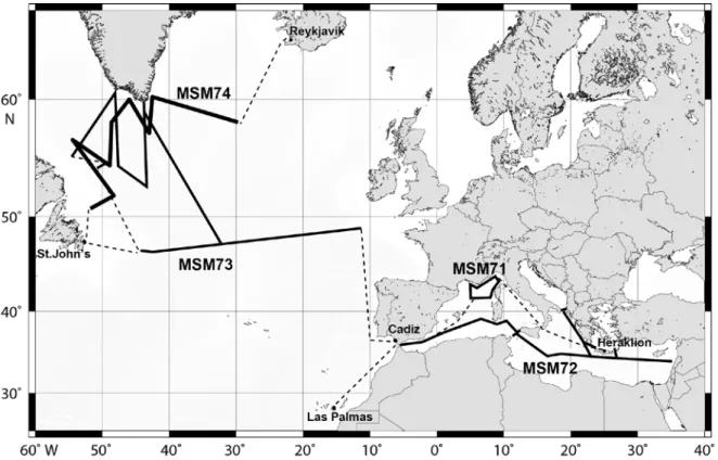
Abb. 1: Geplante Fahrtrouten und Arbeitsgebiete der MERIAN Expeditionen MSM71 – MSM74.
Fig. 1: Planned cruise tracks and working areas of MERIAN cruises MSM71- MSM74.
- 6 -
Wissenschaftliches Programm
Scientific ProgrammeFahrt / Cruise MSM71 – MSM74
Übersicht Fahrt MSM71
Das Ziel der Ausfahrt MSM71 LOBSTER (Ligurian Ocean Bottom Seismology and Tectonics Research) umfasst zwei Kompo- nenten: 1) eine detaillierte refraktions- seismische Untersuchung des Ligurischen Beckens mit dem Übergang von ozeanischer zu kontinentaler Lithosphäre und 2) die Bergung von 29 deutsch/französischen Oze- anbodenseismometern (OBS) im Rahmen der europäischen Initiative AlpArray und des DFG-Schwerpunktprogrammes SPP2017
‚Mountain Building Processes in 4D’
(http://www.spp-mountainbuilding.de/).
Im Zuge von AlpArray wurden mehrere hundert Seismometer im alpinen Raum aus- gebracht, welche das gesamte Orogen abde- cken und hochauflösende Einblicke in die Untergrundstrukturen der Alpen ermöglichen werden. Die seewärtige Komponente von AlpArray umfasst den Einsatz von 29 Breit- band-OBS aus Frankreich und Deutschland in der Ligurischen See. Die Installation der Geräte erfolgte im Juni 2017 von Bord des französischen FS PourquoiPas?; die Bergung soll von FS Maria S. Merian im Rahmen der Ausfahrt MSM71 durchgeführt werden. So- mit können die Kosten von beiden Nationen getragen werden. OBS Aufzeichnungen von teleseismischen Wellen sind eine Vorausset- zung, um unser Verständnis des Übergangs von den westlichen Alpen zu den Apenninen zu schärfen und die dreidimensionale Geo- metrie der Region abzubilden. Zusätzlich zu den passiven Messungen ist die Aufzeich- nung von aktiver Refraktionsseismik entlang zweier 150 nm langer Transekte geplant, die landseitig fortgeführt werden. Diese von kurzperiodischen OBS aufgezeichneten Da- ten werden einen Einblick in die Struktur des Ligurischen Beckens erlauben.
Fahrt MSM72
In den letzten Jahrzehnten haben tiefgreifen- de Veränderungen in der Hydrographie und der Biogeochemie des Mittelmeeres stattge-
Synopsis Cruise MSM71
The aim of cruise MSM71 LOBSTER (Ligu- rian Ocean Bottom Seismology and Tecton- ics Research) is twofold: 1) to conduct a detailed amphibious seismic refraction sur- vey of the Ligurian basin transition from the oceanic to the continental domain, and 2) to recover a network of French/German ocean bottom seismometers (OBS) in the frame- work of AlpArray and the German SPP 2017
‚Mountain Building Processes in 4D’
(http://www.spp-mountainbuilding.de/).
AlpArray is a European initiative with the aim to deploy several hundred closely spaced broadband seismometers that cover the entire Alpine orogen to provide state-of- the-art imaging of subsurface structures. The offshore component of AlpArray involves the deployment of 29 broadband stations from France/Germany in the Ligurian Sea. This deployment took place in June 2017 using the French RV PourquoiPas? as platform.
In order to share ship-related costs between the two nations, recovery will be conducted using RV Maria S. Merian. OBS recordings of teleseismic events will be essential to de- fine subsurface structures at the transition from the Western Alps to the Apennines and improve our understanding of the 3D- geometry of the system and its kinematics. In addition, the two planned active on-offshore wide-angle transect of 150 nm each will un- ravel the upper structure of the Ligurian Basin at crustal scale resolution in particu- lar the ocean-continent boundary at the Alps-Apennines junction which is poorly defined due to the lack of modern refraction data. Short-period OBS will be deployed along the two transects.
Cruise MSM72
The last few decades have seen dramatic changes in the hydrography and biogeo- chemistry of the Mediterranean Sea. The - 7 -
funden. Die komplexe Bathymetrie, die hohe räumliche und zeitliche Variabilität des at- mosphärischen Antriebs und interne Prozes- se tragen zu einem komplexen, instationären Zirkulationsmuster und einer signifikanten Variabilität des biogeochemischen Systems bei. Ein Teil dieser Variabilität kann durch anthropogene Beiträge beeinflusst werden.
Daher ist es erforderlich, diese Details zu dokumentieren und die aktuellen Trends zu verstehen, um die beobachteten Prozesse zuzuordnen und die Auswirkungen der Än- derungen vorhersagen zu können. Das we- sentliche Ziel der Reise ist, zum Verständnis von Langzeitänderungen und Trends in den physikalischen und biogeochemischen Pa- rametern, wie der Aufnahme von anthropo- genem Kohlenstoff, beizutragen und weiter- hin die hydrographische Situation nach den wesentlichen Klimaverschiebungen im östli- chen und westlichen Becken, die als der
„Eastern und Western Mediterranean Tran- sient“ bekannt wurden, zu bewerten.
Auf der Reise werden multidisziplinäre Mes- sungen auf einem im Wesentlichen zonalen Schnitt durch das gesamte Mittelmeer durchgeführt. Die Reise trägt zum globalen
„repeat hydrography program“ GO-SHIP unter Berücksichtigung der GO-SHIP An- forderungen bei.
Fahrt MSM73
Durch seine ausgeprägten Tiefenwasserbil- dungsgebiete nimmt der Nordatlantik im Weltozean und im Klimasystem der Erde eine Schlüsselrolle ein. Hier erfolgt die Um- wandlung von ehemals warmen und salzrei- chen Wassermassen subtropischen Ur- sprungs in kalte nordatlantische Tiefenwas- ser-Rückströme, die u.a. auch für die Belüf- tung des inneren Ozeans von herausragender Bedeutung sind. Durch die globale Erwär- mung wird eine Veränderung des Wärme- und Süßwasser-Haushalts des Nordatlantiks erwartet. Als Konsequenz können sich u.a.
Auswirkungen auf die Stärke der Tiefenwas- ser-Bildung, die Abschmelzraten des grön- ländischen Eisschildes, den Stand des Mee- resspiegels und die räumlichen Muster der allgemeinen Zirkulation ergeben. Dieses Zusammenspiel kann wiederum die klimati-
complex bathymetry, the highly variable spatial and temporal scales of atmospheric forcing and internal processes contribute to generate complex and unsteady circulation patterns and significant variability in bioge- ochemical systems. Part of this variability can be influenced by anthropogenic contri- butions. Consequently, there is a need to document its details as well as to understand ongoing trends in order to better relate the observed processes and to possibly predict the consequences of these changes. The main goal of the cruise is to contribute to the un- derstanding of long-term changes and trends in physical and biogeochemical parameters, such as the anthropogenic carbon uptake and to still evaluate the hydrographical situ- ation after the major climatological shifts in the eastern and western basins, known as the Eastern and Western Mediterranean Transi- ents.
On the cruise, multidisciplinary measure- ments will be conducted on a mainly zonal section along the whole Mediterranean Sea, contributing to the “global repeat hydrogra- phy program” GO-SHIP and adhering to the GO-SHIP requirements.
Cruise MSM73
Due to its pronounced water mass formation regions, the North Atlantic has a pivotal role within the world ocean and the Earth’s cli- mate system. Here, warm and saline water masses of previously subtropical origin are transformed into North Atlantic return flows of cold deep water that are, among others, of high importance for ventilating the interior ocean. Global warming is expected to affect and modify the heat and freshwater budgets of the North Atlantic, with consequences for the intensity of the deep water formation, rates of glacial melting regarding the Green- land ice shield, the state of the sea-level, the spatial patterns of the general circulation, and ultimately for the climatic conditions in western Europe.
- 8 -
schen Bedingungen in Westeuropa beein- flussen.
Um ozeanische Änderungen festzustellen und die an der Veränderung beteiligten Pro- zesse zu verstehen, sind Langzeitmessungen von Schlüsselelementen der Ozean-Zirku- lation notwendig. Diese werden im Rahmen der physikalisch-ozeanographischen Expedi- tion MSM73 erhoben und vorhandene Zeit- reihen somit fortgeführt. MSM73 führt daher in den südlichen und nordwestlichen Teil des subpolaren Nordatlantiks, wo relevante Schlüssel-Elemente beobachtbar sind.
Die zu erfassenden Daten beinhalten schiffs- gestützte Messungen der gesamten Wasser- säule von Temperatur, Salz- und Sauerstoff- gehalt, Strömungsgeschwindigkeit, anthro- pogenen Spurenstoffen und Edelgas- Isotopen. Diese Daten werden um Zeitreihen erweitert, die aus Tiefsee-Verankerungen und am Meeresboden installierten invertier- ten Boden-Echoloten, die mit Drucksensoren ausgestattet sind (PIES), gewonnen werden.
Diese Langzeit-Messgeräte sind entlang 47°/48°N installiert und bilden zusammen mit einem bei ca. 52°30’N befindlichen PIES das Tiefsee-Observatorium NOAC.
Die Untersuchungen der Reise MSM73 sind ein Beitrag zum deutschen Verbundvorhaben RACE-2, welches sich mit der Erforschung der regionalen Zirkulation im Atlantischen Ozean im globalen Wandel befasst und vom Bundesministerium für Bildung und For- schung (BMBF) gefördert wird.
Fahrt MSM74
Die Fahrt MSM74 wird Messungen im Subpolaren Nordatlantik durchführen, die hauptsächlich zu Untersuchungen der Um- wälzzirkulation beitragen. Es werden veran- kerte Messgeräte geborgen und teilweise wieder installiert. Außerdem werden schiffs- gestützte Messungen durchgeführt (CTD, ADCP, Rosettenflaschen).
Der Tiefe Westliche Randstrom (DWBC) im Subpolaren Nordatlantik stellt eine Schlüs- selkomponente der thermohalinen Zirkulati-
In order to determine oceanic changes and to understand processes causing these, long- term measurements of key elements of the oceanic circulation are required. These will be collected during the expedition MSM73 dealing with physical oceanographic pro- cesses, and already existing time series will be continued. MSM73 will therefore be car- ried out in the southern and northwestern part of the subpolar North Atlantic, where relevant key elements are observable.
Data to be collected comprise ship-board measurements of the entire water column regarding temperature, salinity, oxygen, current velocity, anthropogenic tracers, and noble gas isotopes. This is extended by time series data inferred from deep-sea moorings and pressure-sensor-equipped inverted echo-sounders (PIES) installed at the sea bottom. These long-term measurements de- vices are installed along 47°/48°N and to- gether with a PIES located at about 52°30’N form the deep-sea observatory NOAC.
Scientific objectives and measurements of cruise MSM73 contribute to the German cooperative project RACE-2 that deals with investigating the regional circulation in the Atlantic Ocean at times of global change.
Funding is provided by the German Federal Ministry of Education and Research (BMBF).
Cruise MSM74
The cruise MSM74 will carry out measure- ments in the Subpolar North Atlantic, which will mainly contribute to studies of the ther- mohaline circulation. Moored instrumenta- tion will be recovered and some are rede- ployed. In addition, ship-based measure- ments are carried out (CTD, ADCP, rosette bottles).
The Deep Western Boundary Current (DWBC) represents a key component of thermohaline circulation. Fluctuations in - 9 -
on dar. Schwankungen im Volumentransport und der Charakteristik der Wassermassen im DWBC können Indikatoren für Klimaände- rungen sein. Das dichteste Wasser im Rand- strom wird aus der Overflow/Entrainment Quelle (hauptsächlich Dänemark Straße Overflow) im Grönland-Schottland Rücken eingespeist. Leichtere Wasser werden aus den Konvektionsgebieten des Subpolaren Nordatlantiks, hauptsächlich der Labrador- und der Irminger See, eingebracht.
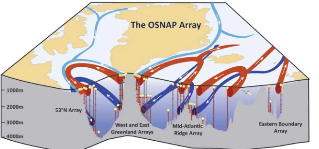
Die Verbesserung der Prozessverständnisse in den Fokusregionen Labrador- und Irmin- ger See wird mit den Daten der Fahrt MSM74 erreicht werden. Die Fahrt ist stark in internationale Programme und Analysen eingebettet, die unter anderem die Stärke der Umwälzzirkulation im Nordatlantik (OS- NAP) und die Kohlenstoffdioxidaufnahme der Labrador- („Ocean Frontiers“) und Ir- minger See (OOI global node Irminger Sea) untersuchen.
Das Arbeitsprogramm der Fahrt MSM74 beinhaltet die Aufnahme und Auslegung von verankerten Geräten und die Vermessung der Wassersäule mit der CTD Rosette und Unterwegsdaten.
volume transport and the characteristics of water masses in the DWBC may be indicators for changes in climate. The densest water in the DWBC originate from the overflow/entrainment source (mainly Denmark Strait Overflow) in the Greenland- Scotland Ridge. Lighter water is formed in the convection areas of the Labrador and the Irminger Sea.
Improvement of process understanding in the focus regions Labrador Sea and Irminger Sea will be achieved with data from the MSM74 cruise. The cruise is embedded in international programs and analysis efforts that examine, among others, the strength of Atlantic overturning circulation (OSNAP) and the carbon dioxide uptake of the Labrador ("Ocean Frontiers") and Irminger Sea.
The work program of the MSM74 cruise include the redeployment of moorings and the surveys of the water column uisng the CTD Rosette and underway data.
- 10 -
Von / From Las Palmas – Nach / To Heraklion Fahrt/Cruise MSM71
Wissenschaftliches Programm
Die Fahrt MSM71 verfolgt zwei wesentliche Ziele: 1) den strukturellen Aufbau des ligu- rischen Beckens sowie den Übergang von ozeanischer zu kontinentaler Lithosphäre zu studieren und 2) ein deutsch/französisches Netzwerk von Breitband-OBS Stationen aus dem AlpArray zu bergen.
Der nordöstliche Teil des Ligurischen Mee- res befindet sich in der Übergangszone von den West-Alpen zum nördlichen Apennin.
In diesem Bereich, den Ligurischen Alpen, wird ein Polaritätswechsel der Subduktion der ozeanischen Platten angenommen. Wäh- rend im Norden die Alpine Platte unter den Alpen abtaucht, wird am südöstlichen Rand der Ligurischen See ein Abtauchen der Ad- riatischen Platte unter den Apennin beo- bachtet. Das Ligurische Becken ist ein Back-Arc Becken, welches durch den süd- ostwärtigen Rückzug der Apennin- Kalabrien-Maghreb Subduktionszone geöff- net wurde. Durch den sogenannten „subduc- tion roll-back“ wurde die kontinentale Krus- te gedehnt und ausgedünnt bis hin zur Aus- bildung eines Back-Arc Spreizungszen- trums, in dem ozeanische Kruste neu gene- riert wurde.
Diese mögliche Entstehungsgeschichte ist nur durch wenige alte Datensätze mit gerin- ger Auflösung belegt. Ziel der Fahrt MSM71 ist es daher, mit Hilfe von zwei mo- dernen refraktionsseismischen Linien, die sich durch engen Stations- und Schussab- stand auszeichnen, die Krustenstruktur, Art und Mächtigkeit, näher zu bestimmen und existierende Theorien zu konsolidieren.
Das Netzwerk aus 29 französischen und deutschen Breitbandseismometern zeichnet Erdbeben über den Zeitraum von acht Mo- naten auf und erweitert das engmaschige Seismometer-Netzwerk der europäischen Initiative AlpArray an Land, das den gesam- ten Alpenraum umfasst. Mit der Integration der marinen Stationen können die Ansätze für die seismische Laufzeittomographie deutlich verbessert werden und somit neue
Scientific Programme
The expedition MSM71 has two major aims:
1) to study the structural geometry of the Ligurian Basin, including the transition from oceanic to continental lithosphere and 2) to recover the 29 broad band OBS sta- tions from a German/French long term net- work.
The north-eastern part of the Ligurian Sea is part of the transition zone from the Alpine orogeny to the Apennine orogeny. In this area, the Ligurian Alps, a change in subduc- tion polarity of the oceanic slabs is pro- posed. North of the Ligurian Sea, the Alpine slab subsides beneath the Alpine belt. In the southeast, the Adriatic plate subsides under- neath the Apennine belt. The Ligurian basin is a back-arc basin, created by the subduc- tion roll-back of the Apennines-Calabria- Maghrebides subduction zone towards southwest. Caused by the roll back of the trench the continental crust was stretched and thinned. A back-arc spreading centre was created that produced new oceanic crust.
Hypotheses about the evolution of the Ligu- rian basin are based on older geophysical and seismic data sets with limited resolution and depth penetration. The aim of the expe- dition MSM71 is to use two modern seismic refraction lines, with a short instrument spacing and a short shot interval, to esti- mate the structure, nature, and the thickness of the crust, to consolidate existing theories.
No long-term network was installed in the past in the Ligurian Sea. The German- French seismic network recorded over a period of 8 months with 29 broadband sta- tions. The network extends the dense seis- mometer network of the AlpArray initiative that covers the entire region of the Alps on- shore. With the integration of the marine stations, seismic traveltime tomographic approaches will be improved and from this - 11 -
Erkenntnisse über die Lage der subduzierten Platten bringen und ebenso zur Beantwor- tung der Fragen zur Geometrie des Polarisa- tionswechsels in der Subduktion beitragen.
Die Schüsse der aktiven Seismik-Profile werden von den Breitbandstationen eben- falls aufgezeichnet. Diese können dazu ver- wendet werden, um die Lage der Horizon- talkomponenten der Seismometer zu be- stimmen, da die Ausrichtung der Geräte beim Auslegen nicht kontrolliert werden kann, weil die Geräte frei durch die Wasser- säule auf den Meeresboden fallen. Durch diese Information kann die Methode der Geräte-Rotation über Umgebungslärm im marinen Einsatz weiterentwickelt werden.
new insights on the location of the subduct- ing slabs in the transition zone between the Alps and the Apennines will be gained and questions on the 3D-geometry of the subduc- tion polarity reversal might be answered.
Additionally, the shots of the active seismic profiles will be recorded by the deployed broadband stations and can be used to de- termine the location of the horizontal com- ponents of the seismometers. Since the OBS are free fall instruments it is not possible to influence the orientation of the instruments.
By means of those additional shot infor- mation, the method to use ambient noise to rotate the seismometer components can be further developed.
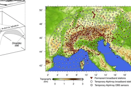
Abb. 2: Links: Schematische Abbildung der Subduktionsgeometrie unter dem Alpen-Apennin-System mit einer Umkehr der Subduktionspolarität (aus Vignaroli et al, 2008). Rechts: Karte der Alpenregion mit den seismischen Stationen, die von der AlpArray Initiative genutzt bzw. installiert wurden.
Fig. 2: Left: Schematic summary of the subduction geometry below the Alps-Apennine system that is charac- terized by a reversal of subduction polarity (from Vignaroli et al., 2008). Right: Map of the Greater Alpine area with seismic stations used or installed by the AlpArray initiative.
Arbeitsprogramm
Nach 5 Tagen Transit (1400 nm) von Las Palmas (Kanaren/Spanien) in das Arbeits- gebiet in der Ligurischen See werden zu- nächst 30 kurzperiodische OBS entlang eines West-Ost Profils auf der Höhe von Korsika in zwei Auslagen ausgesetzt.
Landwärts wird das Profil durch italieni-
Work program
After 5 days of transit from Las Palmas (Canary Islands) into the working area, in total 30 short period OBS will be deployed in two suites along a west-east profile end- ing offshore Corsica. Italian colleagues will provide stations to extend the profile on- shore. The profile will be shot using the - 12 -
sche Kollegen um einige Stationen verlän- gert. Die Geräte werden mit dem GEO- MAR G-Luftpulserarray (86 l) überschos- sen. Danach werden einige der Lang- zeitstationen sowie die Geräte des Refrak- tionsprofiles wieder geborgen. Nach kur- zem Transit folgt ein zweiter Einsatz der kurzperiodischen OBS entlang eines SW- NO Profils. Auch hier wird das Profil landwärts durch unsere italienischen Part- ner mit Landseismometern verlängert.
Das Profil wird erneut mit den Luftpulsern überschossen. Die Länge des Profils hängt dabei vom Arbeitsfortschritt ab, da das Ar- beitsprogramm auf Grund der langen Transitwege zwischen den Häfen und dem Arbeitsgebiet auf 11.5 Arbeitstage redu- ziert werden musste. Auf beiden Profilen wird ein kurzer Streamer mit einer aktiven Gesamtlänge von ~280 m eingesetzt. Da- durch können die oberflächennahen Sedi- mentstrukturen abgebildet werden, die durch die OBS nicht hochauflösend erfasst werden. Im Anschluss werden alle OBS, die kurzperiodischen sowie die Lang- zeitstationen geborgen. Auf dem 3.5 tägi- gen Transit (920 nm) nach Heraklion (Griechenland), werden 0.5 Arbeitstage zum Auslesen der Daten eines akustischen Netzwerkes in der Ionischen See veran- schlagt.
GEOMAR G-Gun array (86 l). Afterwards the western most stations from the long-term network and the instruments along the pro- file will be recovered. A second profile for refraction seismic measurements will be deployed in SW-NE direction. The profile will be extended with land stations onshore by the Italian partners, too.
The G-Gun cluster will be used again to generate shots along the profile. The length of the profile depends on the work progress during the first days of the cruise, since work program had to be reduced to 11.5 working days due to long transit times be- tween the harbours and the working area.
Along both profiles a ~280 m long streamer will be towed behind the vessel to record the upper sedimentary structures. Those struc- tures will be poorly imaged by OBS meas- urements, however they are important for the data analysis. After finishing the second profile all instruments, the stations from the long-term network and the short period sta- tions on the profile will be recovered.
During the 3.5 day long transit (920 nm) to Heraklion (Greece), approximately 0.5 working days will be used to download data from a long-term acoustic network installed in the Ionian Sea.
- 13 -
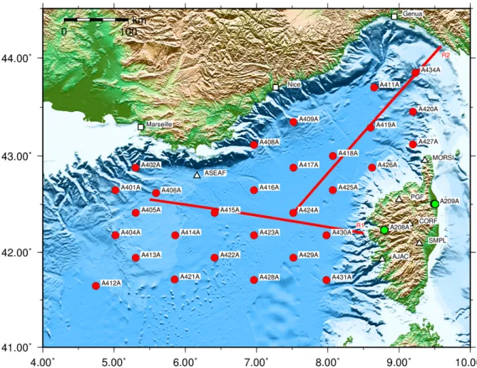
Abb. 3: Geplante Profile (R1 und R2) der MERIAN Expedition MSM 71. Die Kreise markieren die Absetz- positionen der Langzeit-OBS vom Juni 2017.
Fig. 3: Planned profiles (R1 and R2) during MERIAN cruise MSM 71. Dots mark the positions of the long- term OBS deployed in June 2017.
- 14 -
Zeitplan / Schedule Fahrt / Cruise MSM71
Tage/days Auslaufen von Las Palmas (Kanaren) am 07.02.2018
Departure from Las Palmas (Canary Islands) on 07.02.2018
Total 20 Einlaufen in Heraklion (Griechenland) am 27.02.2018
Arrival in Heraklion (Greece) on 27.02.2018 Transit zum Profil R1 (westliches Ende) Transit to profile R1 (western end)
5 Releaser-Test, CTD
Releaser-Test, CTD
0.7 Auslegen OBS auf Profil R1
Deployment OBS profile R1
0.75 Abschießen Profil R1
Shooting along profile R1
1. 4 Bergung OBS vom Profil R1 + Langzeitstationen
Recovery OBS from R1 + long term stations
3.0 3.0 Auslegen OBS auf Profil R2
Deployment OBS profile R2
0.75 Abschießen Profil R2
Shooting along profile R2
1. 4 Bergung OBS vom Profil R2 + Langzeitstationen
Recovery OBS from R2 + long term stations
3.5 Transit Griechenland
Transit to Greece
3.5
- 15 -
Von / From Heraklion – Nach / To Cádiz Fahrt / Cruise MSM72
Wissenschaftliches Programm
Das wissenschaftliche Hauptziel der Fahrt ist es, das Wissen über die verschiedenen Skalen und Größenordnungen der Variabi- lität und über Trends in der Zirkulation, Hydrographie und der Biogeochemie des Mittelmeeres zu erweitern. Schlüsselvariable werden in Schlüsselregionen gemessen, um die Veränderungen, den Grund ihres Auf- tretens und ihre Antriebe zu verstehen. Die- ses ambitionierte Ziel kann natürlich nicht allein durch eine Forschungsfahrt erreicht werden, es benötigt stattdessen eine ange- messene Menge an in Raum und Zeit ver- teilter Daten. Diese Reise wird zur Doku- mentation der Verteilung der Wasser- masseneigenschaften im Mittelmeer beitragen.
Die folgenden wissenschaftlichen Frage- stellungen werden bearbeitet:
1. Was sind die Langzeitveränderungen und/oder Trends in Physik und Biogeochemie im Mittelmeer inklusive ihrer Teilbecken?
2. Wie entwickelt sich die hydrographische Situation im Mittelmeer nach dem
„Eastern Mediterranean Transient“
(EMT) und dem „Western Mediterranean Transient“ (WMT)? Gibt es auch weiterhin einen Trend des Systems zur
„pre-EMT“ Situation zurückzukehren?
Gibt es einen ähnlichen Trend im westlichen Mittelmeer?
3. Wie sind Wirbel im östlichen und westlichen Mittelmeer während der Reise verteilt. Unterscheiden sie sich in den beiden Becken? In welchem Maße werden Wärme und Salz in der Vertikalen durch die Wirbel im westlichen und östlichen Mittelmeer übertragen?
4. Wie hoch ist die Aufnahmerate des anthropogenen Kohlenstoffs im Mittel- meer und verändert sich diese im Laufe der Zeit?
5. Wie hoch sind die Variabilität und die Trends in den biogeochemischen
Scientific Programme
The principal scientific objective of the cruise is to add knowledge to the different scales and magnitudes of variability and trends in the circulation, hydrography, and biogeochemistry of the Mediterranean Sea.
Key variables will be measured in key re- gions in order to understand changes, the reason for occurrence, and the drivers.
These ambitious aims, of course, cannot be reached by one cruise alone, but it requires an adequate amount of data distributed in space and time. The cruise will contribute to the documentation of the water property distribution of the Mediterranean Sea.
The following science questions will be ad- dressed:
1. What are the long-term changes and/or trends in physics and biochemistry in the Mediterranean Sea, including all the sub-basins?
2. How is the hydrographic situation in the Mediterranean developing further on af- ter the Eastern Mediterranean Transient (EMT) and Western Mediterranean Transient (WMT)? Is there still a trend of the system to return to the pre-EMT situation and is there a similar trend in the western Mediterranean?
3. How are eddies distributed in the east- ern and western Mediterranean during the cruise? Do they differ in the sub ba- sins? To what extend is heat and salt transferred into the vertical by eddies in the western and eastern Mediterranean during the cruise?
.
4. What is the rate of uptake of the anthro- pogenic carbon in the Mediterranean and is this changing over time?
5. What is the magnitude of variability and trends in the inventory of bio- - 16 -
Variablen (einschließlich Sauerstoff und Nährstoffe)?
6. Was sind die Basiswerte selten gemes- sener essentieller Ozeanvariablen (EOVs) wie z.B. DOC?
geochemical variables (including oxygen and nutrients)?
6. What are the base-line values of rarely measured Essential Ocean Variables (EOVs) such as DOC?
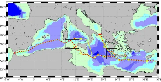
Abb. 4: Arbeitsgebiet und geplanter Reiseverlauf der Reise MSM72. Rote Punkte: CTD/lADCP Stationen, grüne Punkte: alternative CTD/lADCP Stationen, gelbe Quadrate: Aussetzen von ARGO Floats, gelbe Linien: uCTD Stationen, schwarze Quadrate: Gebiete mit hochauflösenden uCTD, ADCP und Thermosalinograph Messungen.
Fig. 4: Working area and planned track of cruise MSM72. Red dots: CTD/lADCP stations, green dots:
alternative CTD/lADCP stations, yellow squares: deployment of ARGO floats, yellow lines: uCTD stations, black squares: areas with high resolved uCTD, ADCP and thermosalinograph measure- ments.
- 17 -
Arbeitsprogramm
Wir führen Messungen von Strömungen und von hydrographischen und biogeochemi- schen Variablen mit den klassischen Mess- geräten, wie CTD, lADCP, ADCP, uCTD, Thermosalinograph und Wasserproben auf hochaufgelösten Schnitten (CTD ungefähr alle 30nm) durch das Mittelmeer durch. Das Wirbelfeld auf den Schnitten wird erfasst durch die hohe Auflösung bei den CTD Sta- tionen, die für die physikalischen Parameter durch die zusätzlichen uCTD Messungen noch erweitert wird. Die Erfassung des Wir- belfeldes wird unterstützt und vervollstän- digt mit Hilfe von Satellitendaten. Satelli- tenbilder vom SAR (space-borne synthetic aperature radar), optische Sensoren und Al- timetrie werden verwendet, um Wirbel ent- lang der Schiffsroute zu identifizieren und, wenn möglich, vom Team an Land aus zu verfolgen.
Die Wasserproben beinhalten Messungen aller Level 1 Variablen, wie sie vom GO- SHIP Programm definiert werden (z.B. Sau- erstoff, Nährstoffe, flüchtige Spurenstoffe und das Kohlenstoffsystem) und biogeo- chemische Messungen, wie EOVs 13C und gelöster organischer Kohlenstoff (DOC).
Diese Daten dienen der Quantifizierung von Trends und Variabilität der Ventilation und der biogeochemischen Zyklen, insbesondere der Aufnahme von anthropogenem Kohlenstoff.
Der Schwerpunkt dieser Reise liegt auf einem Ost-West-Schnitt durch das westliche und östliche Mittelmeer, der östlich von Zypern beginnt und in der Nähe der Straße von Gibraltar endet (siehe Arbeitsgebiet).
Dieser Schnitt ist einer der in GO-SHIP (MED1) vorgesehenen Standardschnitte.
Zusätzlich werden Schnitte durch die Straße von Otranto, durch die Kasos Straße, die Straße von Antikithera, die Straße von Sizilien und durch die Straße von Gibraltar gefahren, um die Ein- und Ausstromraten charakterisieren zu können. Durch die östliche Ionische See werden CTD Stationen gefahren, um die Menge an Levantinischem Zwischenwasser (LIW) ermitteln zu können, das in die Adria fließt und umgekehrt, um den Ausstrom von Adriatischem Tiefen-
Work Programme
We will carry out measurements of current and along-track hydrographic and biogeo- chemical variables with the classical in- strumentation of CTD, lADCP, ADCP, uCTD, thermosalinograph and bottle sam- ples on highly resolved sections through the Mediterranean Sea (CTD about every 30 nm). The high resolution of CTD stations, enhanced for the physical parameters by additional uCTD measurements, will allow us to resolve the eddy field on the sections.
The recognition of the eddy field is also sup- ported and complemented by satellite data.
Satellite imagery from space-borne synthetic aperture radar (SAR), optical sensors and altimetry will be used to identify and, where possible, to track eddies along the vessel’s route by the team on land.
The water sampling program will include measurements of all level 1 variables as defined by GO-SHIP (i.e. oxygen, nutrients, transient tracers and the carbonate system) and measurements of the biogeochemical EOVs 13C and dissolved organic carbon (DOC). These data will be used to quantify trends and variability of ventilation and bio- geochemical cycles, in particular uptake of anthropogenic carbon.
The main focus of this cruise lies on an east- west transect through the Western and East- ern Mediterranean Sea starting east of Cy- prus and ending close to the Strait of Gi- braltar (see working area), which is a repeat hydrography line in GO-SHIP (MED1).
Cross sections through the important pas- sages Strait of Otranto, Kasos Strait, Anti- kithera Strait, Strait of Sicily and Strait of Gibraltar will additionally be conducted in order to characterize the inflow and outflow fluxes. Through the eastern Ionian Sea CTD stations will be carried out to quantify Le- vantine Intermediate Water (LIW) fluxes to the Adriatic Sea and to trace the outflow of Adriatic Deep water (AdDW) into the Ioni- an.
- 18 -
wasser (AdDW) in das Ionische Becken zu verfolgen.
Die meisten Schnitte sind bereits mehrfach befahrene Standardschnitte, so dass Lang- zeitanalysen möglich werden. Auf den verschiedenen Schnitten werden CTD Sta- tionen ungefähr alle 30 nm durchgeführt; in den verschiedenen Straßen noch engmaschi- ger. Insgesamt planen wir, 91 CTD Statio- nen über die gesamte Wassertiefe auszu- führen. Ein lADCP wird an der Rosette in- stalliert, um vertikale Strömungsprofile auf- zuzeichnen. Die CTD wird mit einem Dop- pelpaar aus Temperatur-, Leitfähigkeit- und Sauerstoffsensoren ausgerüstet, die gegen entsprechende Flaschenproben abgeglichen werden, um beste Datenqualität zu gewähr- leisten. Auf fast allen Stationen (abhängig von der Kapazität der Analysemög- lichkeiten) werden Proben für gelösten Sau- erstoff, Nährstoffe, flüchtige Spurenstoffe, DOC und für die Kohlenstoffsystemanalyse genommen. Zwischen den CTD Stationen werden in etwa alle 6 Seemeilen „under- way“ CTD (uCTD) Messungen durchge- führt. Wir hoffen, dabei Maximaltiefen von 800m zu erreichen, je nach Schiffsgeschwin- digkeit, die während der Messung reduziert werden soll. Auf jeder 2. bis 3. CTD Station wird ein uCTD Profil genommen, um die uCTD besser kalibrieren zu können. Wäh- rend der Reise werden zusätzlich aktuelle Satellitendaten vom Landteam analysiert, um die Erkennung von Wirbeln auf der Schiffsroute zu erleichtern. Im westlichen und im östlichen Mittelmeer wird es jeweils einen hochauflösenden Schnitt über einen Wirbel geben, um diesen mehr im Detail zu untersuchen.
Es gibt mehrere kontinuierliche Messungen auf der Reise: Strömungsbeobachtung der oberen ca. 1000m werden mit Hilfe der schiffseigenen 75 und 38 kHz ADCPs durchgeführt. Der Thermosalinograph wird kontinuierliche Oberflächenmessungen der Temperatur und des Salzgehalts liefern. Die pCO2 Messungen dienen dazu, Verbesse- rungen und Leitlinien für den Einsatz von pCO2-Sensoren auf Fähren im Mittelmeer zu erhalten und die dünne Datendichte für pCO2 im Mittelmeer deutlich zu verbessern.
Most of the sections and CTD-positions are repeat occupations in order to allow long term trend analyses. Along the different sec- tions, CTD stations will be conducted ap- proximately every 30 nm; at smaller spacing in the Straits. Altogether we plan for 91 full depth CTD stations. A lowered ADCP (lADCP) will be installed on the Rosette taking vertical velocity profiles. The CTD will be equipped with double pairs of tem- perature, conductivity and oxygen sensors that will be calibrated against discrete bottle samples to guarantee highest possible data quality. Discrete samples for dissolved oxy- gen, nutrients, transient tracer, DOC and carbonate system analysis will be collected at most stations (dependent on analytical capacity). In between the CTD positions underway CTD (uCTD) measurements will be conducted approximately every 6 nm. We expect to reach maximum depths of around 800m depth, depending on the ship’s speed which will be reduced during uCTD de- ployment. For calibration reasons we will repeat on every second/third CTD station an uCTD profile. During the cruise actual sat- ellite data will be additionally analysed by the land team in order to make the detection of eddies on the track easier. In the western as well as in the eastern basin respectively we will make a highly resolved section across an eddy additionally and survey them in more detail.
Several continuous measurements will be taken: Current observations of the upper approximately 1000m will be taken with the 75 and 38 kHz shipboard ADCPs. The ther- mosalinograph will be operated for measur- ing continuous near surface temperature and salinity values. The pCO2 measurements are aimed at providing best practices and guidance for use of pCO2 sensors of ferries in the Mediterranean and to enhance the poor data-base of pCO2 in this area.
- 19 -
Zeitplan / Schedule Fahrt / Cruise MSM72
Tage/days Auslaufen von Heraklion (Griechenland) am 02.03.2018
Departure from Heraklion (Greece) 02.03.2018
Transit zum Arbeitsgebiet / Transit to working area 2 Entfernung zwischen den Stationen: 3255 nm
Distance to go between CTD stations: 3255 nm 18
Stationszeiten, 91 CTD Stationen
Station time, 91 CTD stations 10.5
Vermessung von 2 Wirbeln 2 Survey of 2 eddies
Transit zum Hafen Cádiz 0.5
Transit to port Cádiz
Einlaufen in Cádiz (Spanien) am 03.04.2018 Arrival in Cádiz (Spain) 03.04.2018
Total 33
- 20 -
Von / From Cadíz – Nach / To St. John‘s Fahrt / Cruise MSM73
Wissenschaftliches Programm
Das Ziel der Reise MSM73 ist, physikali- sches Datenmaterial entlang der geographi- schen Breiten 47°/48°N sowie entlang eines Netzes von Messlinien, die die Labradorsee und die südliche Irmingersee queren und vom Reykjanes-Rücken zurück zur 47°/48°N-Linie führen, zu erzielen. Auf diese Weise werden wesentliche Pfade des warmen und des kalten Zweiges der Atlanti- schen Meridionalen Umwälzzelle (AMOC) gequert. Als Teil dieser Umwälzzelle wird warmes, salzreiches Wasser aus den Subtro- pen nach Norden transportiert. Als Folge einer Kette von Umwandlungsprozessen, die in verschiedenen Regionen des Nordatlan- tiks stattfinden (u.a. in der Labradorsee und südlichen Irmingersee), wird daraus kaltes salzarmes Tiefenwasser erzeugt. Dieses ver- lässt über verschiedene Ausbreitungspfade den subpolaren Nordatlantik.
Durch die beteiligten Bildungsprozesse wird den gebildeten Tiefenwassermassen eine bestimmte Charakteristik aufgeprägt, die sich im Ozean messen lässt. Hierzu zählen u.a. eine erhöhte Konzentration von Sauer- stoff und anthropogenen Spurenstoffen. Die räumliche und zeitliche Änderung dieser Charakteristik gibt Aufschluss über die Ausbreitungspfade und Änderungen in den Bildungsprozessen. Mit den während MSM73 geplanten Messungen sollen u.a.
folgende Fragestellungen beantwortet wer- den:
• Wie sieht die aktuelle räumliche Vertei- lung der in den Tiefenwasser- Komponenten messbaren Spurenstoffe CFC-12 und SF6 aus? Wie vergleicht sich diese mit früheren Jahren?
• Wie groß war im Zeitraum 2015/16 bis 2018 die Bildungsrate von Labradorsee- wasser (LSW), welches als leichteste Komponente zum Tiefenwasser beiträgt?
• Wie sehen Eigenschaften und Ausbrei- tungspfade des speziell im Winter 2017/18 gebildeten LSW aus?
Scientific Programme
Cruise MSM73 aims at collecting physical- oceanographic data along the geographic latitudes 47°48°N as well as along a net of survey lines crossing the Labrador Sea and the southern Irminger Sea and leading back from the Reykjanes Ridge to about 47°/48°N.
This way, relevant pathways of the warm and cold branches of the Atlantic meridional overturning cell (AMOC) will be crossed. As part of this overturning cell, warm saline water of subtropical origin propagates to- wards the north. A chain of physical pro- cesses is involved in water mass transfor- mation that takes place in different regions of the North Atlantic (e.g. Labrador Sea and southern Irminger Sea). As a result, fresh and cold deep water is formed that leaves the North Atlantic via various pathways.
Processes contributing to the formation of deep water create a distinct water mass characteristic that is measurable in the ocean. This includes e.g. elevated concen- trations of dissolved oxygen or anthropo- genic tracers. Spatial and temporal changes in these characteristics shed light on water mass propagation pathways and changes in the formation processes. The intended measurements planned during MSM73 serve to address the following research objectives:
• What is the present spatial distribution of the anthropogenic tracers CFC-12 and SF6 that are observable in the deep water components? To what extent is it comparable to previous years?
• What is the respective formation rate of Labrador Sea Water (LSW) in the period 2015/16 to 2018 that contributes to the deep water?
• What are the water mass properties and spreading pathways of the particular LSW vintage formed in winter 2017/18?
- 21 -
• Wie sieht im Frühjahr die Speicherungs- rate von anthropogenem Kohlenstoff im subpolaren Nordatlantik aus, und in wel- chem Maße hat sie sich im Vergleich zu früheren Jahren geändert?
• Wie groß ist der Beitrag von glazialem Schmelzwasser, welches seinen Ursprung im grönländischen Eisschild hat und in die Wassersäule des Ozeans eingetragen wird?
• Wie stark ist der Tiefenwasser-Export bei 47°/48°N im Zeitraum 2017-2018 im Vergleich zum nordwärtigen Eintrag des warmen, salzreichen Wassers aus den Subtropen?
• Wie groß ist der Austausch zwischen dem West- und dem Ostbecken der mit dem Nordatlantikstrom mitgeführten Wassermassen, und inwiefern sind Ände- rungen im Vergleich zu früheren Jahren mit Schwankungen in der Lage der Sub- polar-Front erklärbar?
• Wie variabel ist das Strömungsfeld im Ostatlantik, was bestimmt seine Variabi- lität, und welche Strom-schwankungen jenseits von starken Gezeiten-Signalen lassen sich im östlichen Randstromsys- tem feststellen?
• What is the storage rate of anthropogen- ic carbon in the subpolar North Atlantic, and to what degree has it changed com- pared to previous years?
• What is the contribution of glacial melt- water originating on the Greenland Ice Sheet that is introduced into the water column of the ocean?
• What is the strength of the deep water export across 47°N in 2017-2018 in comparison to the northward import of warm saline water of subtropical origin?
• What is the magnitude of the exchange between the western and the eastern ba- sins of the North Atlantic, and to what extent are respective variations com- pared to previous years linked to chang- es in the location of the Subpolar Front?
• How variable is the current field in the eastern Atlantic, what determines its variability, what kind of flow variability apart from large tidal changes is ob- servable in the eastern boundary cur- rent?
- 22 -
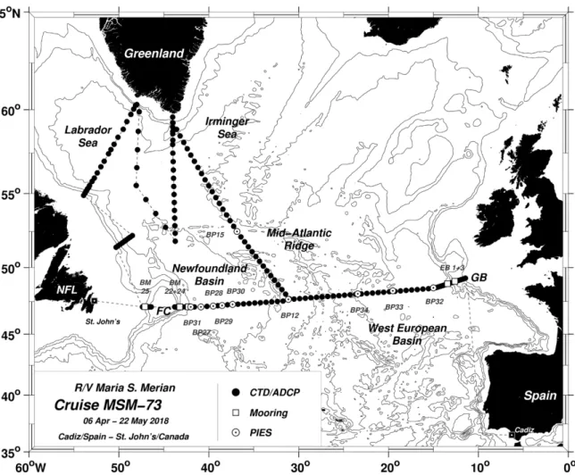
Abb. 5: Arbeitsgebiet und geplanter Fahrtverlauf der Reise MSM73. Hydrographische Schnitte sind durch schwarze Punkte hervorgehoben. Weiße Quadrate kennzeichnen Verankerungen, weiße Kreise die Po- sitionen der mit Drucksensoren ausgestatteten invertierten Echolote (PIES).
Fig. 5: Working area and planned track of cruise MSM73. Hydrographic sections are highlighted by black dots. White squares denote mooring locations, and white circles represent the locations of inverted echo-sounders equipped with pressure sensors (PIES).
Arbeitsprogramm
Das Arbeitsprogramm der Reise MSM73 hat seinen Schwerpunkt entlang 47°/48°N sowie in der Labradorsee und südlichen Irminger- see im nordwestlichen subpolaren Nordat- lantik (Abb. 5).
Nach dem Verlassen von Cadíz/Spanien erfolgt ein mehrere Tage andauernder Tran- sit zur irischen Schelfkante. Dort werden wir die im Frühjahr 2017 an der topographi- schen Erhebung Goban Spur ausgelegten Tiefseeverankerungen EB-1 und EB-3 ber- gen und anschließend neu auslegen. Wäh- rend des Transits erfolgen Test-Stationen mit Geräte-Tests.
Work Programme
The work programme of cruise MSM73 focuses on field work to be carried out along 47°/48°N as well as in the Labrador Sea and southern Irminger Sea in the northwestern subpolar North Atlantic (Fig. 5).
After leaving Cadíz/Spain we will be on transit for several days until we reach the Irish shelf break. At the topographic obsta- cle called Goban Spur we will recover and later on redeploy the two deep-sea moorings EB-1 and EB-3 that have been installed there in spring 2017. While on transits we will perform test stations to check the scien- tific instrumentation.
- 23 -
Von der irischen Schelfkante aus führt uns der Weg entlang 47°/48°N nach Westen zum Mittelatlantischen Rücken (MAR). Auf dem Weg dorthin erfolgt von der Schelfkan- te aus ein hydrographischer Schnitt mit Spu- renstoff-Analyse durch das tiefe Westeuro- päische Becken. Hierbei kommt das CTDO2/lADCP-Sensor-System mit Kranz- wasserschöpfer-Einheit zum Einsatz.
Im Frühjahr 2017 installierten wir am Mee- resboden des tiefen Westeuropäischen Be- ckens drei mit Bodendrucksensoren ausge- stattete invertierte Bodenecholote (PIES;
BP-32, BP-33 und BP-34), deren Messdaten nun über Methoden der akustischen Tele- metrie ausgelesen werden. Zusammen mit den Daten des auf der Westseite des MAR befindlichen PIES BP-12 wollen wir somit die Stärke der Zirkulation im tiefen Becken im Zeitraum 2017-2018 abschätzen. PIES BP-12 wird zudem geborgen und gegen ein mitgebrachtes Instrument ausgetauscht.
Auf dem weiteren Weg nach Westen hin zur Flämischen Kappe und der Flämischen Pas- sage erfolgen weitere hydrographische Mes- sungen mit Spurenstoff-Analyse sowie das akustische Auslesen der Messdaten der fünf PIES BP-27 bis BP-31. Vier mit einem zu- sätzlichen Strömungsmesser ausgerüstete PIES (sogenannte C-PIES) werden anschlie- ßend geborgen und für eine spätere Neuaus- legung vorbereitet. Diese zusätzlichen Strö- mungsmesser sollen Aufschluss über die bodennahen Strömungen liefern und auf diese Weise dazu beitragen, die Unsicher- heiten in den späteren Transportabschätzun- gen für das Neufundlandbecken zu minimie- ren.
Am Osthang der Flämischen Kappe, die das tiefe Neufundlandbecken auf seiner Westseite begrenzt, werden wir die beiden im Frühjahr 2017 ausgelegten Tiefsee- Verankerungen BM-22 und BM-24 bergen und im Verlaufe der Reise für eine weitere Neuauslegung vorbereiten. Die hydro- graphischen Messungen mit Spurenstoff- Analyse werden dann in der westlich
Starting at the Irish shelf break, we will con- tinue westwards along 47°/48°N and then reach the Mid-Atlantic Ridge (MAR). While on the way, we will carry out hydrographic stations including tracer analysis along a line leading from the shelf break into the deep Western European Basin. On these stations we will use the CTDO2/ lADCP- instrument-package attached to a water sampler unit.
In spring 2017 we installed three inverted echo-sounders equipped with pressure sen- sors (PIES) on the bottom of the deep West European Basin (BP-32, BP-33 and BP-34).
The respective data will be retrieved via methods involving acoustic telemetry. In combination with the data recorded by PIES BP-12 installed on the western side of the MAR we will infer the strength of the circu- lation in the deep basin in the period 2017- 2018. PIES BP-12 will furthermore be re- covered and replaced by a new device brought with us.
On the way west towards Flemish Cap and Flemish Pass there will be further hydro- graphic stations with tracer sampling and analysis. We will also read out telemetrical- ly data recorded by the five PIES BP-27 to BP-31. Four of these PIES were previously equipped with an additional currentmeter (so-called C-PIES). These will be recovered and prepared for a later redeployment. The additional currentmeter shall deliver infor- mation about the bottom-near current and thus help to minimize uncertainties in the respective volume transports in the New- foundland Basin inferred later on.
Flemish Cap limits the deep Newfoundland Basin on its western side. There, we will recover the two deep-sea moorings BM-22 and BM-24 deployed on the eastern flank of Flemish Cap in spring 2017. Throughout the cruise they will be prepared for a later redeployment. Hydrographic casts and tracer analysis will be continued in Flemish Pass. There, we will also recover and - 24 -
gelegenen Flämischen Passage fortgesetzt.
Dort erfolgt dann auch die Bergung und Neuauslegung der Verankerung BM-25.
Wir verlassen dann den südlichen Rand des Subpolarwirbels und arbeiten uns nach Norden in die Labradorsee vor.
Hydrographische Schnitte über den tiefen westlichen Randstrom hinweg erfolgen am nördlichen Eingang zum Orphan-Becken sowie dann in der zentralen Labradorsee.
Die Spurenstoff-Analyse soll hier zusammen mit den Messungen in der Labradorsee Aufschluss über die Ausbreitung des Nordatlantischen Tiefenwassers und seiner Komponenten sowie der diesjährigen Was- sermasseneigenschaften geben.
In der Labradorsee sowie rundum die Süd- spitze von Grönland werden wir auf den hydrographischen Stationen auch Proben zur Abschätzung von Edelgas-Konzentrationen (Helium- und Neon) nehmen. Hieraus soll später der Anteil an glazialem Schmelz- wasser im Ozean bestimmt werden, welches seinen Ursprung auf dem grönländischen Eisschild hat.
Entlang von verschiedenen hydro- graphischen Schnitten arbeiten wir uns dann in Richtung Grönland vor oder wieder zurück in die Labradorsee, bis wir schließlich die südliche Irmingersee kreuzen und auf der Westseite des MAR in Richtung 47°/48°N-Schnitt fahren. Auf dem Weg dorthin werden die Daten des PIES BP-15 durch akustische Telemetrie ausgelesen und ein Schnitt zwischen den PIES-Positionen BP-15 und BP-12 durchgeführt. Hierdurch soll der Austausch zwischen dem West- und dem Ostatlantik untersucht und entsprechen- de Volumen-Transporte des Nordatlantik- stroms (NAC) beim Queren des Rückens quantifiziert werden.
Schließlich werden die zuvor geborgenen C- PIES BP-27 bis BP-31 und die Randstrom- Verankerungen BM-22 und BM-24 wieder auf ihren Positionen entlang 47°/48°N in- stalliert. Wir schließen damit unsere Feld- arbeiten im Neufundlandbecken ab und bre-
redeploy mooring BM-25.
We will then leave the southern rim of the subpolar gyre and head north towards the Labrador Sea. Hydrographic sections will be carried out across the boundary current region near the northern entrance to the Orphan Basin as well as in the central Labrador Sea. The tracer analysis thus shall provide information about down-stream spreading of North Atlantic Deep Water and its component as well as about ist present property characteristics.
On the various sections in the Labrador Sea as well as on those radiating around the southern tip of Greenland we will also take noble gas samples (helium and neon). These serve to estimate the contribution of glacial meltwater that originates from the Greenland ice sheet.
We head either towards or away from Greenland along various sections before crossing the southern Irminger Sea and following along the western flank of the MAR towards the 47°/48°N section On the way towards the south we will recover data recorded by PIES BP-15 via acoustic telemetry and will carry out a section located between the two PIES stations BP- 15 and BP-12. This will allow us to infer the exchange between the western and the eastern North Atlantic and thus contribute to quantifying respective volume transports of the North Atlantic Current (NAC).
Along 47°/48°N, we will finally redeploy the previously recovered C-PIES BP-27 to BP- 30 and install again the two deep-sea moorings BM-22 and BM-24 on their previous positions. This will end our scientific field work, and we will head - 25 -
chen in Richtung St. John’s/Neufundland auf, um dort unsere Reise zu beenden.
Während der gesamten Reise wird das schiffseigene akustische Doppler-Strö- mungsprofil-System (ADCP) in den Vari- anten 38 kHz- und das 75 kHz zum Einsatz kommen, um während der Fahrt kon- tinuierlich die Geschwindigkeitsstruktur in den oberen 800-1200 m der Wassersäule zu vermessen. An den geplanten Mess-Sta- tionen erfolgt die Wasserproben- und Daten- aufnahme mit dem Wasserschöpfer-System und der CTDO2/lADCP-Messeinheit (Mes- sungen von Leitfähigkeit, Temperatur, Tiefe und Sauerstoff sowie Geschwindigkeits- messungen). Wasserproben dienen der Ei- chung der Sauerstoff- und Leitfähigkeits- sensoren des CTDO2-Systems und geben In- formationen über den im Meerwasser vor- handenen Gehalt an anthropogenen Spuren- stoffen (SF6, CFCs), Kohlenstoff-/Sauer- stoff-Isotopen und Edelgasen (Helium und Neon).
Unterwegs-Messungen des schiffseigenen Thermosalinographen liefern kontinuierlich oberflächennahe Messungen der Temperatur und des Salzgehaltes, die Aufschluss über die Lage der schelfnahen Randströme und des NAC geben sollen. Entlang der 47°/48°N-Linie sowie in der südlichen Labradorsee werden wir sieben profilierende Argo-Drifter aussetzen, die zum internationalen globalen Argo-Programm beitragen. Sie liefern über einen Zeitraum von ca. 5 Jahren Informationen über die Temperatur und den Salzgehalt in den obe- ren 2000 m der Wassersäule.
towards St. John’s/Newfoundland to end our mission there.
Throughout the entire cruise we will contin- uously operate the two vessel-mounted Acoustic Doppler Current Profiler (ADCP) systems (38 kHz and 75 kHz versions). They will capture the velocity structure of the upper water column down to 800-1200 m.
Intended stations serve to collect water samples and profile data using the water sampler system and attached CTDO2/lADCP units (measurements of conductivity, tem- perature, depth, oxygen, and current veloci- ty). Water samples will be analysed to cali- brate the conductivity and oxygen sensors as well as to obtain information on the sea- water concentration of anthropogenic trac- ers (SF6, CFCs), certain isotopes (carbon and oxygen isotopes), and noble gases (heli- um, neon).
Underway measurements of the shipboard thermosalinograph will continuously deliver near-surface temperatures and salinities providing information on the location of shelf-near boundary currents and the NAC.
Seven profiling Argo floats will be deployed along 47°/48°N as well as in the southern Labrador Sea. They contribute to the inter- national and global Argo program and for about five years deliver temperature and salinity information for the upper 2000 m of the water column.
- 26 -
Zeitplan / Schedule Fahrt / Cruise MSM73
Tage/days Auslaufen von Cadíz (Spanien) am 06.04.2018
Departure from Cadíz (Spain) 06.04.2018
Transit zum Arbeitsgebiet / Transit to working area 4
Aufnahme und Auslegung von Tiefsee-Verankerungen 4
Recovery and redeployment of deep-sea moorings
Akustische Telemetrie, Aufnahme und Auslegung von PIES 2.5 Acoustic telemetry, recovery, and redeployment of PIES
CTDO2/lADCP/Spurenstoff-Schnitte mit Unterwegsmessungen zwischen Stationen 29.5 CTDO2/lADCP/tracer-sections with underway measurements between stations
Transit zum Hafen St. John‘s 1
Transit to port St. John’s
Total 41 Einlaufen in St. John‘s (Kanada) am 22.05.2018
Arrival in St. John’s (Canada) 22.05.2018
- 27 -
Von / From St. John’s –
Nach / To Reykjavik Fahrt / Cruise MSM74
Wissenschaftliches Programm
Der Nordatlantik ist eine der Schlüsselregi- onen für die globale Ozeanzirkulation und deren Variabilität auf zwischenjährlichen und längeren Zeitskalen. Globale Klimaän- derungen sind mit Änderungen im Zustand des Nordatlantiks eng gekoppelt. Das Klima Europas ist zu einem erheblichen Teil mit der ozeanischen Zirkulation, insbesondere dem Transport von warmem Wasser mit dem Nordatlantikstrom nach Nordosten, verbunden. Der Nordatlantikstrom stellt eine Verbindung zwischen dem warmen, subtro- pischen Wirbel und dem kalten, subpolaren Wirbel dar. Ein wichtiger Antrieb für den Austausch zwischen diesen großskaligen Wirbeln, und damit ein Kontrollmechanis- mus für den Nordatlantikstrom, ist das Ab- sinken von Wasser im nördlichen Nordatlan- tik. Durch starke Abkühlung (Dichteanrei- cherung) werden im Winter oberflächennahe Wassermassen in Tiefenwasser transfor- miert. Dieses geschieht sehr intensiv nörd- lich des Grönland-Schottland Rückens in den „Nordic Seas“, aber auch in der Labra- dor See, der Irminger See und in Regionen südlich von Grönland.
Die dichtesten Wassermassen im Kaltwas- ser-Pfad der thermohalinen Zirkulation wer- den beim Einströmen durch die Dänemark Straße gebildet. Diese Wassermassen eta- blieren den „Tiefen Westlichen Randstrom“
(DWBC; Abb. 6). Die Wassermassen aus den Konvektionsregionen der Irminger und Labrador See tragen ebenfalls, als leichtere Komponenten und weiter südlich, zum DWBC bei. Sowohl die Stromstärke, wie auch die Charakteristik der Wassermassen im DWBC, sind Indikatoren für oberflä- chennahe Änderungen, die eventuell in die Tiefsee eingebracht werden.
Um eventuell auftretende Trends in den Transporten und der Wassermassencharakte- ristik zu ermitteln, werden lange Zeitserien
Scientific Programme
The North Atlantic Ocean is one of the most important drivers for the global ocean circu- lation and its variability on time scales be- yond inter-annual. It could be shown that global climate variability is to a large extent triggered by changes in the North Atlantic sea surface state. The climate of Europe is strongly influenced by the North Atlantic ocean circulation, in particular the eastward transport of warm water with the North At- lantic Current has a strong impact on the mild winters in Northern Europe. The North Atlantic Current is to be seen as a connec- tion between the warm, subtropical Gyre and the cold, subpolar Gyre. A driver for the connection between the gyres, and as such for the North Atlantic Current, is the water mass transformation, and in particular the sinking of water, in the Northern North At- lantic – north of the Greenland-Scotland Ridges and in the Labrador and eventually Irminger Sea.
Intense cooling in winter make the surface water more dense and drives a sinking of the water. The water that has been transferred from surface to great depth spreads prefer- entially southward, concentrated in intense currents (Fig. 6). Most prominent is the
“Deep Western Boundary Currents”
(DWBC) that transports water ventilated water masses in a well defined current southward. Beside the deep water formed in the subpolar gyre, the DWBC transport wa- ter from the overflow regions southward.
The strength as well as the characteristic of the DWBC are an indicator for the integral effect of time variability in the formation region of the water masses and the process- es in the overflow region.
As such it is critical to survey the DWBC regularly and over long periods of time to create time series of flow and properties to - 28 -