Supplement Material
Case Studies of two extreme storm situation within the 20th Century
Two storm events are selected to analyse differences between NOAA-20CR and ERA-20C during the early and late 20th century to assess in how far uncertainties in the representation of cyclones as well as their associated strong wind fields vary within the past century in both datasets.
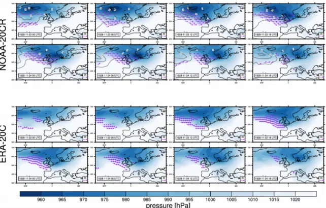
Storm on 23/24. November 1928
An intense storm in late November 1928 affected the British Isles as well as parts of Central Europe. The comparison of mean sea level pressure (MSLP) fields between ERA-20C and NOAA- 20CR suggest a similar general pattern in both datasets, however, regional differences are apparent (Figure S1). The cyclone tracks as identified in NOAA-20CR reveal a north-westward propagation of the cyclone centres during late November with a fairly small spread between different ensemble members (28 selected members, Figure S2). During the later stage after passing the British Isles most of the selected members show a similar cyclone track with the exception of one member. The time development of the cyclone in ERA-20C is similar to the development in NOAA-20CR, however, slightly shifted southwards.
All windstorm tracks in NOAA-20CR members follow the cyclone track until about 10°E (Figure S3). Afterwards some tracks continue further east, whereas some travel south. The wind event in ERA-20C is detected later compared to NOAA-20CR but agrees well with all the
windstorms in NOAA-20CR until it reaches 10°E east. Afterwards, the wind field track propagates southward, similar to some tracks in NOAA-20CR. To understand why some windstorm tracks are found to travel towards the Mediterranean, it is analysed in how far further cyclone tracks possibly related to high wind speeds over the Mediterranean region are apparent. It is found that a secondary cyclone existed over the Mediterranean, which is present in NOAA-20CR and ERA-20C. Thus, it might be the case that the windstorm event from the northerly cyclone is linked to the wind field of the cyclone present in the Mediterranean at this later development stage.
Storm Kyrill on 17-19. January 2007
For the late 20th century the storm Kyrill is chosen to be compared between ERA-20C and NOAA- 20CR. As expected the time development of mean sea level pressure fields is very similar between ERA-20C and NOAA-20CR, which is probably influenced by the larger number of observations available at the end of the century (Figure S4). This is supported by the standard deviation within the NOAA-20CR ensemble members, which is only about 10% of those found for the storm in 1928. Consequently, cyclone tracks are very similar between NOAA-20CR and ERA-20C, with only a small ensemble spread within NOAA-20CR (Figure S5). However, in ERA-20C Kyrill is divided into two cyclones, which nearly overlap each other, which might be caused by the tracking method used. Resembling the results for the cyclone track of Kyrill, the associated windstorm events are also similar in NOAA-20CR and ERA-20C with again a shorter track in ERA-20C (Figure S6). Overall the higher agreement between NOAA-20CR and ERA-20C for storm Kyrill suggest that wind fields as well as mean sea level pressure fields are better constrained by surface observations at the end of the 20th century compared to the beginning.
Figure S1: Storm on 23/24. November 1928 as represented in NOAA-20CR (top panel) and ERA-20C (bottom panel). Mean sea level pressure (MSLP) fields given as filled contours and arrows indicate regions with wind speeds exceeding 15 m/s (on the 0.995 sigma level for NOAA-20CR and 10-meter height for ERA-20C). Furthermore, the ensemble standard deviation of MSLP is given for NOAA-20CR (grey lines).
Figure S2: Cyclone tracks for the event in November 1928 as represented in 28 selected NOAA-20CR members (blue lines) and ERA-20C (red line). Additionally, another cyclone track over the Mediterranean region is included.
Figure S3: Windstorm tracks for the event in November 1928 as represented in 28 selected NOAA-20CR members (blue lines) and ERA-20C (red line).
Figure S4: Storm Kyrill on 17/19. January 2007 as represented in NOAA-20CR (top panel) and ERA-20C (bottom panel). Mean sea level pressure (MSLP) fields given as filled contours and arrows indicate regions with wind speeds exceeding 15 m/s (on the 0.995 sigma level for NOAA-20CR and 10-meter height for ERA-20C). Furthermore, the ensemble standard deviation of MSLP is given for NOAA-20CR (grey lines).
Figure S5: Cyclone tracks for storm Kyrill as represented in 28 selected NOAA-20CR members (blue lines) and ERA-20C (red line).
Figure S6: Windstorm tracks for storm Kyrill as represented in 28 selected NOAA-20CR members (blue lines) and ERA-20C (red line).