A palaeogeographic and geoarchaeologic study on the Colchian plain along the Black Sea coast of
Georgia
Inaugural-Dissertation zur
Erlangung des Doktorgrades
der Mathematisch-Naturwissenschaftlichen Fakultät der Universität zu Köln
vorgelegt von Hannes Laermanns
aus Köln
Köln, 2018
Berichterstatter/Gutachter: Prof. Dr. Helmut Brückner PD Dr. Martin Kehl
Tag der mündlichen Prüfung: 19.01.2018
I
Abstract
The Colchian plain forms the central part of the Georgian coast. Due to its protected area between the ridges of the Greater and Lesser Caucasus and the resulting mild climate it constitutes a refugee area for thermopile species during the last glacial maximum (LGM) as well as an ideal location for early human occupation. Despite the existence of excellent geobio-archives, the number of geoarchaeological and palaeogeographical studies in the Black Sea area in general, and in Georgia in particular is – compared to e.g. the Mediterra- nean – rather small. Therefore, this study shall (i) decipher Mid- to Late Holocene landscape changes, with special attention given to (ii) the Holocene relative sea-level (RSL) rise. In the context of the Black Sea-level history it is of special interest (iii) whether the water level rose oscillating or continuously. Furthermore, (iv) the geoarchaeological investigations on settlement mounds shall clarify the influence of those landscape changing processes on human occupation of that region and (v) establish a chronostratigraphy that eventually ver- ifies the mounds' Bronze age origin.
This study is based on sediment cores that were gained from different locations on the Colchian plain between the rivers Enguri and Supsa. By using sedimentological and geo- chemical analyses (e.g., XRF and XRD-scans, LOI measurements, laser particle analyser etc.), sediment facies shifts in the natural depositional patterns and anthropogenic influence could be determined. Age estimations were established by using AMS-radiocarbon and lu- minescence (IRSL) dating and rendered a chronostratigraphy.
Consequently, an extensive landscape change in the research area was proven for the last 8000 years. While the coastline stayed more or less stable due to the extensive long-shore drift, its hinterland was turned through enduring sediment infill from an open lagoon into an alluvial floodplain since 3500 cal BC. Meanwhile the RSL rose continuously from -10 m below its modern level until it reached ~-2 m between 3000 and 1000 cal BC: Sub- sequently, the rise decelerated until it reached its modern level. These processes contradict the theory of an oscillating RSL rise, as proposed i.e. in the Balabanov-curve for the Geor- gian coast. They endorse instead the model of a continuous RSL evolution of the Black Sea.
The investigated settlement mounds exemplify human occupation since at least the early 2
ndmillennium BC and verify archaeology-based implications of their Bronze Age origin.
The stratigraphy of the settlement mounds hints rather an intentional accumulation of sedi-
ment layers than a succession of settlement layers as known from tells. The warm and
humid climate that prevailed during their occupation and their environs that were dominated
II
by extensive wetlands back that assumption and exemplify the dependence and need for adaption strategies of human settlement to their surroundings.
It was the first time, that a combination of sedimentological, geochemical and dating ap-
proaches gained further knowledge on the landscape evolution of the Colchian plain and
the relative sea-level evolution and gave first insights into human settling in complex envi-
ronmental conditions.
III
Kurzzusammenfassung
Die kolchische Tiefebene bildet den zentralen Abschnitt der georgischen Küstenniederung.
Aufgrund ihrer geschützten Lage, zwischen dem Großen und Kleinen Kaukasus und dem daraus resultierenden milden Klima, stellt das Areal sowohl einen Rückzugsraum für ther- mophile Arten während des letzten glazialen Maximums (LGM) als auch einen Gunstraum zur Besiedlung durch den Menschen dar. Trotz hervorragender Geobio-Archive ist die Zahl paläogeographischer und geoarchäologischer Untersuchungen des Schwarzen Meeres und im Besonderen der georgischen Küste, vor allem im Vergleich zum Mittelmeerraum, bisher eher gering. Daher soll mit dieser Dissertationsarbeit (i) der mittel- bis spätholozäne Landschaftswandel entschlüsselt werden. Ein besonderes Augenmerk liegt hierbei auf (ii) der relativen Meeresspiegelentwicklung während des Mittel- bis Spätholozäns, die den Landschaftswandel maßgeblich beeinflusst hat. Besonders der Frage, (iii) ob der Meeres- spiegelanstieg kontinuierlich oder oszillierend verlief, wird hier nachgegangen. Darüber hin- aus wird der Einfluss des Landschaftswandels auf die menschliche Besiedlung, anhand der (iv) geoarchäologischen Untersuchungen von Siedlungshügeln entschlüsselt und (v) eine Chronostratigraphie dieser speziellen Siedlungsform erstellt.
Die durchgeführten Untersuchungen basieren in erster Linie auf Bohrungen, die in verschie- denen Lokalitäten des Untersuchungsgebietes entlang der Küste zwischen den Flüssen Enguri und Supsa abgeteuft wurden. Das gewonnene Probenmaterial wurde im Geolabor der Universität zu Köln granulometrisch und geochemisch untersucht. Anhand der durch- geführten Analysen konnten verschiedene Ablagerungsfazies definiert und Rückschlüsse auf den Landschaftswandel und anthropogenen Einfluss ermittelt werden. Datierungen mit- tels AMS-Radiokohlenstoffmethode und Lumineszenzverfahren (IRSL) ermöglichten eine zeitliche Einordnung der Prozesse.
Basierend auf den gewonnenen Ergebnissen konnte ein umfassender Landschaftswandel
im Laufe der letzten 8000 Jahre im Untersuchungsgebiet festgestellt werden. Während die
durch Küstenlängstransport geformte Küste relativ konstant blieb, verlandete(n) ab etwa
3500 v. Chr. die dahinterliegenden Lagune durch den anhaltenden fluvialen Sedimentein-
trag (insbesondere des Rioni) zunehmend. Der Meeresspiegel stieg im selben Zeitraum
von etwa 10 m unter seinem heutigen Niveau kontinuierlich an, erreichte zwischen 3000
und 1000 v. Chr. ein Niveau von etwa -2 m und stieg seitdem deutlich verlangsamt an bis
er sein heutiges Niveau erreichte. Diese Ergebnisse widerlegen für den georgischen Küs-
tenraum die weitverbreitete Theorie eines oszillierenden Schwarzmeer-Spiegels und bele-
gen einen kontinuierlichen Schwarzmeeranstieg.
IV
Anhand der untersuchten Siedlungshügel konnte eine menschliche Besiedlung seit min- destens dem Beginn des zweiten Jahrtausends v. Chr. nachgewiesen werden, was sich mit bronzezeitlichen Funden aus dem Umfeld der Hügel deckt. Die Stratigraphie der Hügel deu- tet auf eine gezielte Errichtung innerhalb eines kurzen Zeitraums hin, was in Anbetracht des feucht-warmen Klimas und der Entwicklung der von Sumpfland geprägten Küstenebene sinnig scheint und als beispielhafte Anpassungsstrategie auf die natürlichen Gegebenhei- ten gesehen werden kann.
Somit konnte erstmalig mittels verschiedener geochemischer, sedimentologischer und ge-
ochronologischer Methoden der mittel- bis spätholozäne Landschaftswandel der kolchi-
schen Tiefebene, inklusive der relativen Meeresspiegel-Entwicklung und der menschlichen
Besiedlung analysiert werden.
V
Acknowledgements
Firstly, I would like to thank my supervisor, Prof. Dr. Helmut Brückner, for enabling me to work within his research group. Initially as a student assistant and later as a PhD student and scientific team member, he continuously showed support throughout my PhD thesis and scholarship application and provided motivation and encouragement to pursue my own ideas during my PhD research. I sincerely thank him for showing trust in me and for allowing me to work independently on my project. I'm grateful for his scientific supervision, financial support and continued encouragement throughout.
Besides my supervisor I would like to thank my mentors. I thank Dr. Daniel Kelterbaum for his support with my scholarship application, initializing the project and developing research ideas. Without his initiative on the Georgia project it wouldn't exist. I am grateful for his support and cooperation during the fieldwork.
Further, I would like to express my heartfelt gratitude to Dr. Simon Matthias May. His moti- vation, professional as well as personal support were of great comfort during difficult peri- ods. His guidance, constructive criticism and scientific skills brought my research to higher levels.
In addition, I would like to thank Dr. Nick Marriner for supervision during my stay at the Université de Franche Comté in Besançon and for his willingness to support me over the last few years in general. In particular, with regards to language editing and scientific mat- ters.
Thanks to Dr. Stephan Opitz for general laboratory instructions and support while writing my publications. He familiarized me with the majority of analysis methods and has proven to be a very constructive co-author.
I owe great thanks for the helpful support of Prof. Suzanne Leroy from Brunel University Uxbridge, UK (now Centre Européen de Recherche et d’Enseignement des Géosciences de l'Environment [CEREGE], Aix-en-Provence, France) for palynological analysis as well as for her invitation to present my findings at Brunel University and for her keen interest in potential future cooperation.
Furthermore, I thank PD Dr. Martin Kehl who agreed to co-supervise this thesis and for his advice concerning analysis methods and the structure of my thesis. Also, I thank Prof. Dr.
Frank Schäbitz and Dr. Simon Matthias May for being part of the commission of my PhD
defence.
VI
My dissertation project was funded by the Heinrich Böll Foundation. I am extremely thankful to them for giving me this opportunity. With such support I was able to turn my project ideas into reality. Beyond the financial support, I thank the Heinrich Böll Foundation for the men- toring and networking programme that put me in touch with so many people who are work- ing in different disciplines and are involved in so many projects. This interdisciplinary ex- change of ideas has vastly broadened by experiences.
I thank the Graduate School of Geosciences, and especially Dr. Karin Boessenkool, for the Fellowship grant that enabled me to continue with my PhD, for the travel grants, trainee programme and especially the personal support during my entire PhD. Furthermore, I would like to thank the Albertus Magnus Graduate Centre that funded my research stay at Univer- sité de Franche Comté in Besançon, France.
Many thanks to Melanie Bartz, Simon Matthias May, Nick Marriner, Maike Norpoth, Juliane Scheder, Dennis Wolf and Alan Palmer for tirelessly proof reading my thesis. Also, special thanks to Giorgi Kirkitadze and Jan Verheul for supporting me with the graphics and layout.
Our fieldwork would never have taken place, nor had been so successful without the support of our colleagues from the Ilia State University in Tbilisi, in particular Dr. Mikheil Elashvili, Giorgi Kirkitadze and Levan Navrozashvili. They provided accommodation in the Marine Research Center in Grigoleti, supported myself and my team in countless ways and en- deavoured to make everything possible. At this point I would also like to thank all students who supported me during those field trips, Julian Rölkens, Jan Verheul, Arne Heisterkamp and Svenja Riedesel for their interest, patience and great company. In particular, I acknowledge the latter two for writing excellent bachelor theses within this project.
Moreover, I thank all my colleagues from the research group and my companions and friends at the Institute of Geography with whom I spent so much time with at work as well as socially. In particular, I would like to acknowledge Helge Aasen, Moritz Breul, Dominik Brill, Lisa Ehlers, Kristof Dorau, Corinna Földi, Sebastian Frank, Georgina King, Sebastian Kock, Ulrike Lussem, Matze May, Maike Norpoth, Gilles Rixhon, Jule Scheder, Friederike Stock, Jan Verheul, Dennis Wolf and many more. Special thanks to Melanie Bartz for joint field and laboratory work while working as student assistants, and for accompanying me throughout all ups and downs during our PhD theses.
Finally, I would like to thank my family, especially my grandmother and father. But above all, my mother, for universal support throughout my thesis and in my life in general. I owe you everything.
And lastly, I dedicate this thesis to my grandfather, Hans-Jürgen Schiffer. He had always
been my idol and I thank him for all his kindness, generosity and understanding. He was
VII
always profoundly interested in my studies and would have loved to see this completed thesis. He passed away on the day I submitted my PhD application.
VIII
Table of Contents
Abstact………...………….………....I Kurzzusammenfassung………...………...III Acknowledgements………....….V Table of Contents………...………...…...VIII List of Figures………...………...….XIII List of Tables………...………...XVI
1 Introduction ... 1
1.1 Holocene Palaeogeography and Geoarchaeology ... 1
1.1.1 The sea-level evolution of the Black Sea ... 2
1.1.2 Geoarchaeology in the coastal areas of the Black Sea region ... 5
1.2 The significance of the Colchian plain’s geo-bio-archives ... 6
1.3 Objectives of the present study ... 7
1.4 Research design and applied methodology ... 9
1.4.1 Field work ... 9
1.4.2 Sedimentology and geochemistry ...12
1.4.3 Geochronology ...13
1.4.4 Outline of the study ...13
1.5 The study area ...14
1.5.1 Physical setting ...14
1.5.2 Archaeological background ...18
1.5.3 Geography of the study area: research sites and situation ...21
2 Mid- to Late Holocene landscape changes in the Rioni delta area (Kolkheti lowlands, W Georgia) ...23
2.1 Introduction ...24
2.2 Regional setting ...26
IX
2.2.1 Geological and geomorphological framework ...26
2.2.2 Palaeoenvironmental changes and sea-level fluctuations ...26
2.2.3 Human occupation and archaeological background ...28
2.3 Methods ...28
2.3.1 Field work ...28
2.3.2 Geochemical and sedimentological analyses...29
2.3.3 Dating techniques ...30
2.4 Results ...31
2.4.1 The beach-foredune ridges and the adjacent hinterland (KUL 1 – KUL 3) ..31
2.4.2 The Kolkheti wetlands – master cores KUL 7 and PAPO 2 ...32
2.4.2.1 Sediment core KUL 7 ...32
2.4.2.2 Sediment core PAPO 2 ...33
2.4.3 Additional stratigraphic information along the coring transects A and B ...34
2.4.4 Radiocarbon and IRSL dating results ...37
2.5 Discussion ...39
2.5.1 Facies interpretation ...39
2.5.1.1 Facies A: shallow marine (?) ...39
2.5.1.2 Facies B: sublittoral to littoral ...39
2.5.1.3 Facies C: lagoonal ...41
2.5.1.4 Facies D: alluvial (overbank deposits) ...41
2.5.1.5 Facies E: semi-terrestrial (peat) ...42
2.5.1.6 Facies F: fluvial ...42
2.5.1.7 Facies G: aeolian ...42
2.5.1.8 Facies H: anthropogenic ...43
2.5.2 Chronostratigraphic interpretation of sediment cores ...43
2.5.2.1 Trenches KUL 1 and 2, core KUL 3 ...43
2.5.2.2 Master cores KUL 7 and PAPO 2 ...44
2.5.3 The evolution of the Kolkheti lowlands ...45
2.5.4 Implications for the local relative sea-level evolution ...47
X
2.6 Conclusion ...50
2.7 Acknowledgements ...51
2.8 References ...51
2.9 Appendix – Sublementary data. ...57
2.9.1 Sample preparation for luminescence (IRSL) dating ...57
2.9.2 References ...58
3 Bronze Age settlement mounds on the Colchian plain at the Black Sea coast of Georgia – a geoarchaeological perspective ...60
3.1 Introduction ...61
3.2 Regional Setting ...63
3.2.1 Physical Setting ...63
3.2.2 Human Occupation and Archaeological Background ...64
3.2.3 Research Area ...66
3.3 Methods ...68
3.3.1 Fieldwork ...68
3.3.2 Geochemical and Sedimentological Analyses...68
3.3.3 Dating Techniques ...70
3.3.4 Remote Sensing ...70
3.4 Results ...71
3.4.1 Sedimentology and Stratigraphy ...71
3.4.1.1 Sediment Core ERG1-1 ...71
3.4.1.2 Sediment Core ORU1-1 ...72
3.4.1.3 Sediment Core ORU 2-1 ...73
3.4.1.4 Sediment Core ORU3 ...74
3.4.1.5 Other Sediment Cores ...75
3.4.2 Radiocarbon Dating Results ...76
3.4.3 Statistical Analyses of Sedimentological and Geochemical Data ...77
3.4.4 Remote Sensing, DSM and volume estimation of Mound Ergeta 1 ...78
3.5 Discussion ...79
XI
3.5.1 Facies Determination ...79
3.5.1.1 Facies 1: Fluvial (Channel Deposits) ...79
3.5.1.2 Facies 2: Alluvial (Floodplain Deposits/Overbank Deposits) ...79
3.5.1.3 Facies 3: Anthropogenic ...80
3.5.2 Chronostratigraphic Interpretation and Palaeoenvironmental Setting ...81
3.5.3 Size and Source Material of the Mounds ...82
3.5.4 Mode of Construction and Occupation Phases ...85
3.6 Conclusions ...87
3.7 Acknowledgements ...88
3.8 References ...89
4 Coastal lowland and floodplain evolution along the lower reach of the Supsa River (Western Georgia) ...96
4.1 Introduction ...98
4.2 Regional Setting ... 100
4.2.1 Physical Setting ... 100
4.2.2 Human Occupation ... 102
4.2.3 Research area ... 103
4.3 Methods ... 104
4.3.1 Geochemical and Sedimentological Analyses... 104
4.3.2 Dating Techniques ... 106
4.4 Results ... 106
4.4.1 Sediment cores ... 106
4.4.1.1 Sediment core SUP 3 ... 106
4.4.1.2 Sediment core SUP 9 ... 107
4.4.1.3 Sediment core SUP 4 ... 108
4.4.1.4 Sediment core SUP 10 ... 109
4.4.1.5 Sediment core SUP 5 ... 110
4.4.1.6 Sediment core SUP 6 ... 110
4.4.1.7 Sediment core SUP 7 ... 112
XII
4.4.1.8 Sediment core PIC 2... 112
4.4.2 Radiocarbon Dating Results ... 113
4.4.3 Statistical Analyses of the Sedimentological and Geochemical Data ... 114
4.5 Discussion ... 115
4.5.1 Facies determination ... 115
4.5.1.1 Facies A: sublittoral to littoral ... 115
4.5.1.2 Facies B: alluvial (overbank deposits) ... 116
4.5.1.3 Facies C: semi-terrestrial (peat and organic-rich deposits) ... 116
4.5.1.4 Facies D: lagoonal/coastal lake ... 116
4.5.1.5 Facies E: fluvial ... 117
4.5.1.6 Facies F: anthropogenic ... 117
4.5.2 Implications for the local relative sea-level evolution ... 117
4.5.3 Palaeo-environmental evolution of the Supsa delta area ... 120
4.5.4 Human occupation ... 123
4.6 Conclusions ... 123
4.7 Acknowledgements ... 124
4.8 References ... 125
5 Discussion ... 134
5.1 Significant landscape and environmental changes during the Holocene ... 134
5.2 Holocene sea-level curve of the Black Sea coast of Georgia ... 137
5.3 Evaluation of the RSL evolution in the context of the Black Sea curve debate . 140 5.4 Human occupation – the Colchian settlement mounds ... 141
5.5 A chronostratigraphy of the Colchian settlement mounds ... 142
6 Conclusion and Outlook ... 144
7 References ... 147
Appendix A……….………...…XVII
Paper Contribution……….………...……..XXII
Erklärung ……….………...……....XXIII
XIII
List of Figures
Fig. 1.1: Coastal areas as archives in geoarchaeological and palaeogeographical research
………...……….1
Fig. 1.2: Compilation of different sea-level curves for the Black Sea ………....3
Fig. 1.3: Research design of the study ………...10
Fig. 1.4: Digital Elevation Model (DEM) of the research area ...….15
Fig. 1.5: Photos of the research area...……....…..17
Fig. 1.6: Overview of the history of ancient Colchis...19
Fig. 1.7: Study area...22
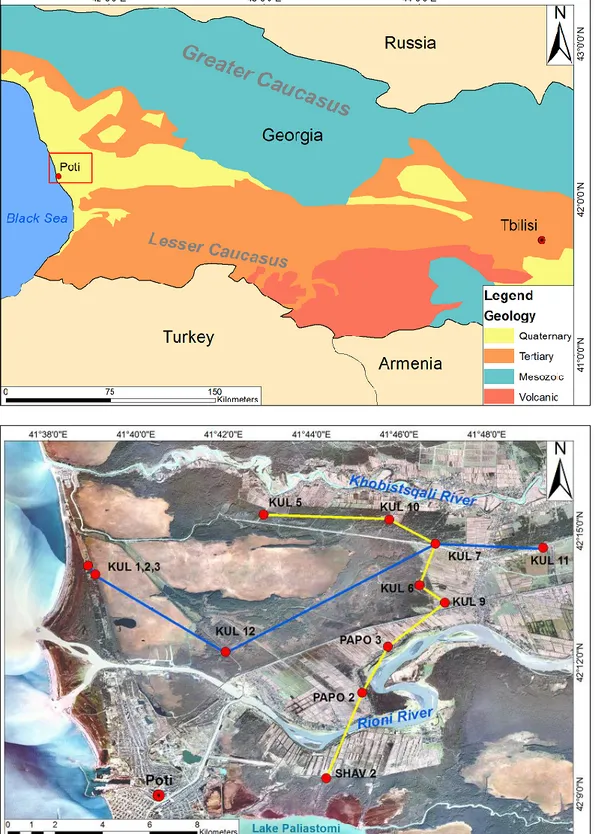
Fig. 2.1: Overview of the research area with location of coring sites and trenches ………...…25
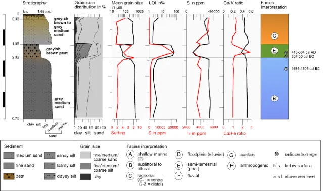
Fig. 2.2: Facies interpretation, granulometry, geochemistry and
14C age estimates of the sediment core KUL 3………...……….…...31
Fig. 2.3: Facies interpretation, granulometry, geochemistry and age-depth model of the sed- iment core KUL 7...33
Fig. 2.4: Facies interpretation, granulometry, geochemistry and age-depth model of the sed- iment core PAPO 2...34
Fig. 2.5: Transect A crossing the research area from W to E...35
Fig. 2.6: Transect B crosses the research area in S-N direction...36
Fig. 2.7: Principal component analysis (PCA), Ternary plot of mean grain size, sorting and Ca/K ratio and Mineralogical compositions...40
Fig. 2.8: Compilation of
14C-dated samples from the Kolkheti lowlands and their relative position to the local sea level...49
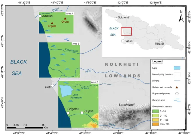
Fig. 3.1: Overview of the occurrence of settlement mounds in the Colchian plain (Colchis)
in Western Georgia and the mounds
Ergeta 1, Orulu 1 & Orulu 2...62XIV
Fig. 3.2: Photos of the mounds Ergeta 1, Orulu 1, and Orulu 2. ...67 Fig. 3.3: Drilling procedure, sediment core ORU1-1 and, a flint flake taken from sediment
core ORU2-1
......69 Fig. 3.4: Facies interpretation, granulometry, geochemistry and
14C age estimates of the
sediment core ERG1-1...71 Fig. 3.5: Facies interpretation, granulometry, geochemistry and
14C age estimates of the
sediment core ORU1-1...73 Fig. 3.6: Facies interpretation, granulometry, geochemistry and
14C age estimates of the
sediment core ORU2-1...73 Fig. 3.7: Facies interpretation, granulometry and geochemistry of the sediment core
ORU3...75 Fig. 3.8: Principal component analysis (PCA) and plot of normalized Al and Zn concentra-
tions...78 Fig. 3.9: Schematic cross section of the two settlement mounds Orulu 1 and Orulu 2...83 Fig. 3.10: DEM, Orthophoto, Elevation cross sections, 3D model and projection combination of settlement mound Ergeta 1...85 Fig. 3.11: Chronology of the geoarchaeological and palaeoenvironmental evolution of the settlement mounds and their surroundings...86
Fig. 4.1: Map of the research area...99 Fig. 4.2: Digital elevation model (DEM) of the research area...101 Fig. 4.3: Natural swamp forest vegetation close to the site of sediment core PIC 2 (A) and
northward view from the foothills south of the village of Supsa (B)...102
Fig. 4.4: Sediment core SUP 3 from the maximum depth at 11 m b.s. (bottom right) to the
surface (top left)...106
Fig. 4.5: Profile, facies interpretation, granulometry, geochemistry and
14C age estimates of
the sediment core SUP 3...107
Fig. 4.6: Profile, facies interpretation, granulometry, geochemistry and
14C age estimates of
the sediment core SUP 4...108
Fig. 4.7: Profile, facies interpretation, granulometry, geochemistry and
14C age estimates of
the sediment core SUP 10...110
XV
Fig. 4.8: Profiles, facies interpretation, granulometry and geochemistry of the sediment cores SUP 5, SUP 6 and SUP 7...111 Fig. 4.9: Profile, facies interpretation, granulometry, geochemistry and
14C age estimates of the sediment core PCI 2...112 Fig. 4.10: PCAs to decipher the sediments' origins and depositional modes...114 Fig. 4.11: Sea-level index points based on radiocarbon dating of the Supsa delta region with a first estimated sea-level curve...118 Fig. 4.12: Palaeoenvironmental evolution of the Supsa delta region and the adjacent ar-
eas...121
Fig. 5.1: Palaeoenvironmental evolution of the research area since 3000 BC...135 Fig. 5.2: Estimated sea-level curves of the surroundings of the Rioni delta and Kulevi swamps and the Supsa area...139
Fig. A.1: Facies interpretation, granulometry, geochemistry and
14C age estimates of the
sediment core KUL 13...XVIII
Fig. A.2A: Pollen analysis (part I)...XX
Fig. A.2B: Pollen analysis (part II)...XXI
XVI
List of Tables
Tab. 2.1: Radiocarbon data sheet.………...………...……....38
Tab. 2.2: Luminescence age estimates of the beach ridges of Kulevi...38
Tab. 3.1: Radiocarbon data sheet...76
Tab. 4.1: Radiocarbon data sheet...113
1
Chapter 1
1 Introduction
1.1 Holocene Palaeogeography and Geoarchaeology
The disciplines of Holocene palaeogeography, a part of the Quaternary science, and geo- archaeology are comparably young research fields used to contextualize human (pre-) his- tory. Whilst classical archaeology is able to look back on a several centuries-long tradition, research on human societies in their specific environments is rather new (Marriner &
Morhange 2006). During the past two decades, archaeologists have become increasingly aware of the importance of the environment in understanding the socio-economic and nat- ural frameworks of ancient societies (Marriner et al. 2010).
Due to their long and continuous settlement histories, the Fertile Crescent, the Mediterra- nean, northern Africa and Europe are regions of high interest for geoarchaeolological and palaeogeographical studies. In particular, coastal areas yield potentially rich archives. For instance, they document the different aspects of natural forcing (e.g., sea-level changes,
Fig. 1.1: Coastal areas as archives in geoarchaeological and palaeogeographical research (Mar- riner et al. 2010, modified 2017).
2
climate and vegetation history; Fig. 1.1; Marriner et al. 2010). This is especially true for coastal environments; however, information on their hinterland is also provided by sediment supply from fluvial systems (Haghani et al. 2015). Furthermore, their sedimentary archives may show evidence for the transition from natural to human-influenced environments (Brückner 2005).
Since the end of the postglacial transgression ~6000 years ago, coastal areas have become densely settled regions in many parts of the world, especially in the Mediterranean and the neighbouring seas. Here, the great civilizations (Greek, Roman, Phoenician etc.) left mani- fold anthropogenic traces – e.g. harbours, cities, fishing industries, trade economy, defor- estation and agricultural land use (Marriner & Morhange 2006, 2007). Therefore, the inter- disciplinary approach of geoarchaeology (Brückner & Gerlach 2011) is well suited to recon- struct natural and anthropogenic landscape-forming processes during the Holocene (see 1.4.4). This holds especially true for the Black Sea region with its specific Holocene sea- level curve and settlement history.
1.1.1 The sea-level evolution of the Black Sea
Global sea level underwent extensive changes during the Late Pleistocene and Holocene.
After falling to its lowest position of ca. 120 m below today's level during the Last Glacial Maximum (LGM) around 20,000 years ago, sea level rose at an average rate of 1.5 cm/yr from ca. 14,000 BP onwards, reaching a near-present position around 6000-5500 BP (Clark
& Mix 2002, Clark et al. 2009, Brückner et al. 2005, Lambeck & Purcell 2005). While this holds true for the Mediterranean the relative sea-level (RSL) evolution of the Black Sea is, according to literature, rather complex. There is in fact a great deal of confusion, in particular when looking into older publications from Russian authors.
It is assumed by many authors that during MIS 2 sea level dropped below the Bosporus sill leaving the Black Sea separated from the world ocean. If so, it must have been a giant freshwater lake (Panin & Popescu 2007), which was considerably lower than today's level.
The new hypothesis to explain the great deluge, i.e. the Genesis Flood published by Ryan
et al. (1997) and Pitman & Ryan (1998) started a controversial debate on the timing and
mode of the Holocene reconnection of the Black Sea with the Mediterranean. These authors
assume that after the separation from the Mediterranean, the Black Sea was catastrophi-
cally flooded via the Bosporus in the course of the global warming that followed the LGM
since its water table had remained significantly lower. The reconnection was initially dated
to ~7500 BP (Ryan et al. 1997) and later corrected to ~8400 BP (Ivanova et al. 2007, Ryan
3
et al. 2007, Giosan et al. 2009). It is still debated, if a catastrophic flooding did indeed take place (e.g., Ryan et al. 1997, Pitman & Ryan 1998, Ballard et al. 2000, Lericolais et al. 2007, 2009) or rather a gradual or oscillating sea-level harmonization (e.g., Chepalyga 2002, Hiscott et al. 2002, Balabanov 2007) or whether the Black Sea level was always high and had a continuous waterflow into the Marmara Sea (Aksu et al. 1999, 2002).
Since the reconnection of the Black Sea with the Mediterranean via the Bosporus Strait, different RSL scenarios are assumed (Pirazzoli 1991, Martin & Yanko-Hombach 2011).
Several studies proposed an oscillating curve, mainly referring to older studies (e.g., Os- trovsky et al. 1977, Voskoboinikov et al. 1982, Balabanov 1984, Chepalyga et al. 1984), spanning a wide range of scenarios that differ in the extent and number of oscillations (Pi- razzoli 1991, Brückner et al. 2010). Even after the reconnection with the Mediterranean Sea, the curve differ significantly (cf. Fig. 1.2; see also Brückner et al. 2010). E.g., the po- sition of sea level around 5000 BC shows great differences: -5 m below the current sea level (b.s.l.) (Filipova-Marinova 2007) to more than -20 to -30 m (e.g., Voskoboinikov et al.
1982, Balabanov 2007). Thereafter, they differ dramatically in the number and amplitude of oscillations (“wiggles”) and variations (cf. Fig. 1.2).
Fig. 1.2: Compilation of different sea-level curves for the Black Sea. Older publications (e.g., NEV = Nevessky 1970, OST = Ostrovsky et al. 1977, VOS = Voskoboinikov et al. 1982, CHEP = Chepalyga et al. 1984) are summarized in the so called Balabanov curve (BAL = Balabanov 2007) the most prominent, but not the only modern RSL curve that propagates significant oscillations (e.g., FIL = Filipova-Marinova 2007). They conflict with RSL-models of Brückner et al. 2010 (BRÜ), Kelterbaum et al. 2011 (KEL) and Fouache et al.2012 (FOU) that indicate a continuous sea-level rise (mean values presented here). Own design 2017.
4
The so-called Balabanov-curve, lastly published in 2009 (Balabanov 2009) is based on sev- eral of these former models and uses their available (uncalibrated) radiocarbon dates (Mar- tin & Yanko-Hombach 2011). It can be seen as a summary and "consensus-curve" for the oscillating RSL. Lately, Bolikhovskaya et al. (2017) distinguish six small amplitude trans- gressions and seven regressive phases of different magnitudes during the last 7400 years in accordance with Martin et al. (2007) and Martin & Yanko-Hombach (2011).
The Phanagorian Regression is the best known – but also most debated – of these regres- sive phases. It was first proposed by Fedorov in 1963 who noted a sea-level drop of ~5-6 m in the Mid-1
stmillennium BC (Fouache et al. 2012). It is based on the location of archae- ological remains of the Milesian Greek city of Phanagoria (and other adjacent archaeologi- cal sites); parts of these settlements lie submerged in the Gulf of Taman (Porotov 2007).
Though the sea-level curves propagating an oscillating RSL rise reveal a different trend, they evoke a significant regression-transgression cycle during the 1
stmillennium BC (Bala- banov 2009, Fouache et al. 2012).
Conversely, there are several publications (e.g., Nevessky 1970, Hiscott et al. 2002; Giosan et al. 2009, Brückner et al. 2010, Kelterbaum et al. 2011 & 2012, Fouache et al. 2012 ) that reject (significant) regressive cycles since the reconnection of the Mediterranean and the Black Sea via the Bosporus Strait; these authors present evidence for a continuous RSL rise instead. They point out that after the reconnection both water bodies must have reacted as a communicating system, because the glacio-eustatic effects had been the same (Brück- ner et al. 2010). No major Holocene regressions are known from the Mediterranean (e.g., Marriner & Morhange 2006, Morhange 2005, Vött & Brückner 2006, Brückner et al. 2006, Vött 2007, Seeliger et al. 2014) their existence must be doubted for the Black Sea as well.
Even data from the western part of the Black Sea, in particular the Danube delta, hint at a more or less stable sea level (± 1.5 m) during this period (Giosan et al. 2006).
Studying the Taman Peninsula and the Kuban delta region, which includes the sites of the
so-called Phanagorian regression, Brückner et al. (2010) and Fouache et al. (2012) discard
the existence of major RSL fluctuations. Instead they proposed a gradual sea-level rise from
7 to 6 m below present sea level around 5000 BC to ~2 m b.s.l. around 2000 BC, and a
continued slow rise until today (Brückner et al. 2010). Were there, however, minor climate-
induced variations (Behre 2003, Leorri et al. 2006), eventually <2 m, as proposed for the
Colchis region (Dzhanelidze 2007) and for the Thracian Black Sea coast of Turkey (between
5.4 and 3.5 ka BP; Erginal et al. 2013)? This question is still open, since these variations
were as yet not found in the Aegean Sea.
5
1.1.2 Geoarchaeology in the coastal areas of the Black Sea region
The number of geoarchaeological studies on the Black Sea region is significantly lower than on the Mediterranean Sea. This may be explained by its peripheric position during the an- tiquity. The Mediterranean, the Roman
mare internum, hosts a great number of ancientcities, such as Greek, Roman, Egyptian, Phoenician, with a huge potential for geoarchaeo- logical research (e.g., for Rome [Portus & Ostia]: Delile et al. 2014, Goiran et al. 2014; for Alexandria: Flaux et al. 2017; for the Levant: Marriner et al. 2010; for Ephesus: Brückner 2005, Kraft et al. 2007, Stock et al. 2013, 2016, for Pergamum/Elaia: Seeliger et al. 2013, 2014, for Miletus lately Brückner et al. 2014). This also holds true for Palaeolithic to Neolithic sites as well (e.g., Zielhofer et al. 2008, Linstädter & Kehl 2012; Kehl et al. 2013). Nowa- days, the Black Sea's location in the periphery of Europe, and its decade-long restricted accessibility during the Soviet Period is another reason for the few number of palaeogeo- graphical and geoarchaeological publications. Plus, many publications were written in Rus- sian or even in local languages.
Nevertheless, there is a certain and increasing number of palaeogeographical and geoar- chaeological studies in the Black Sea region. In particular, several Milesian Greek colonies and their hinterlands in the western and northern part have been investigated in recent years. A number of studies focussed on the different progradation stages of the Danube delta and the environmental impacts for Neolithic to medieval settlements (e.g., Carozza et al. 2012, Romanescu 2013) Research on the ancient city of Histria, on the southern margin of the Danube delta, and its role as a trading town in the context of spit formation and the isolation of the harbour from the open sea can be seen as a good example (Vespremeanu- Stroe et al. 2013, Romanescu 2014, Preoteasa et al. 2017). Further examples south of the Danube delta are the diatom- and chrysophycean stomatocysts-based study of Chalcolithic to Early Bronze Age environments at Lake Durankulak (Ognjanova-Rumenova 2008) or investigations on coastal changes at the ancient Milesian colony of Appolonia Pontica, the present-day Sozopol in Bulgaria (Baralis et al. 2011, Flaux et al. 2016).
The Taman and Crimean peninsulas, which are separated by the Strait of Kerch, the ancient
Cimmerian Bosporus, are another Black Sea area where several geoarchaeological studies
have been carried out. Given that many of the Greek colonies were located on the penin-
sulas' shores (Koschelenko & Kusnetsow 1998) most geoarchaeological studies focus on
their environs and the resulting interdependencies, e.g. the Dorian Greek colony of Cher-
sonesos (Carter et al. 2000). Furthermore, Kelterbaum et al. (2011, 2012) investigated on
the Kerch Peninsula, the easternmost part of Crimea and on the Taman coastline changes
that separated extended embayments and inlets from the open sea. Special attention was
6
given to the ancient Greek colony of Phanagoria due to the so-called Phanagorian Regres- sion, which was proven to be a wrong concept (Brückner et al. 2010, Fouache et al. 2012).
Beyond classical Greek sites, some Palaeolithic to Bronze Age sites were investigated un- der the aspect of land-use changes (Burke et al. 2008), including aspects of pedogenesis (e.g. Cordova et al. 2011, Cordova 2016).
Other than the coasts of Romania and Bulgaria – with a focus on the Danube delta – and the Crimean/Taman region, only scattered geoarchaeological investigations have been car- ried out in the Black Sea region. This is surprising, since there is still a great number sites of (geo-) archaeological interest. This holds especially true for the Black Sea coast of Geor- gia, where until a couple of years ago, very few international projects had been undertaken.
Beside the Palaeolithic site of Dmanisi (e.g., Gabunia et al. 2000, Lordkipanidze et al. 2007, Messager et al. 2009, 2011) some sites in eastern Georgia were investigated (e.g., Hansen et al. 2007, von Suchodoletz et al. 2015). The political situation in Abkhazia and, until 2004, in Adjara hindered research and limited investigations on several parts of Western Georgia only. Since then, some archaeological sites, e.g. Hispani, on the southern part of the Geor- gian coast, have been the subject of geoarchaeological research (Connor et al. 2007, de Klerk et al. 2009, Janelidze & Tatashidze 2010).
1.2 The significance of the Colchian plain’s geo-bio-archives
The Kolkheti lowlands, or Colchian plain, which equates with the historical region of Colchis, is the central part of the Georgian coast. Its topographical location differs from the other areas of the Black Sea. Between the ranges of the Greater Caucasus in the north and the Lesser Caucasus in the south it is protected against the cold winters of the steppes in the north and the Anatolian plain in the south (Eppelbaum & Keshin 2012). This situation makes the Colchian plain special for various reasons:
This topographical situation allowed thermopile species to survive the glacial periods in this refuge area. Hence, western Georgia is one of only three areas in western Asia where ter- tiary relict species survived and can be found through to today (Röhrig 1991, Connor et al.
2007). While tundra vegetation prevailed during the last glacial maximum (LGM) in most
parts of Europe, it is assumed that Georgia had deciduous and mixed forests existed (Tar-
asov et al. 2000). Furthermore, the endemic percolation bogs, which can be found in mires
southeast of Lake Paliastomi, underline the uniqueness of the region (Joosten et al. 2003,
Haberl et al. 2006).
7
Beside its ecological importance, the Colchian plain stands out with its extraordinary long and continuous human occupation. In the adjacent Kura catchment, the oldest hominid re- mains outside of Africa were discovered at the site of Dmanisi (Gabunia et al. 2000). The protected location of the Colchian plain, with its mild climate, has always favoured human occupation, and allowed an early transition from hunting and gathering to farming and ani- mal husbandry societies between 10000 and 9000 BC until the Chalcolithic (Lordkipanidze 1991, Arslanov et al. 2007).
Beyond these special characteristics of the region, the Colchian plain is also notable be- cause of its excellent palaeoenvironmental archives. The strong long-shore drift (Korotaev et al. 2003) and meandering rivers with their high sediment supply (Berkun et al. 2015) flowing down from the adjacent foothills and the Caucasus ranges created vast lagoons and delta fans. Such water bodies, with their gradual infill of fine-grained floodplain sediments and peat growth (Chapter 2), are ideal archives for sea-level reconstructions (Haghani et al. 2015) and palaeo-environmental research (e.g., for the western Black Sea shores: Gio- san et al. 2006, for the Caspian: Leroy et al. 2011, for the Aegean: Brückner 2005, Brückner et al. 2006). Furthermore, they provide the potential to document the transition from envi- ronments dominated by natural processes to strongly anthropogenic-influenced environ- ments (Brückner 2005), whilst also covering geoarchaeological aspects too.
1.3 Objectives of the present study
As already stated (see Chapter 1.1.2), only very few geoarchaeological and palaeogeo-
graphical studies have been carried out in the coastal lowlands of Georgia, although this
region is very well suited for this kind of research. The present study aims at filling the gap
by investigating the evolution of the western Georgian landscape during the Holocene. It
focuses on landscape formations, changes of the coastline and the environments and the
vegetation history as well as the human-environment interactions during the last eight mil-
lennia. Three working hypotheses were formulated, which are subdivided into five research
goals.
8
Working hypothesis 1: Georgia's coastal areas underwent significant landscape and environmental changes during the Holocene.
Goal 1: Reconstructing the Holocene evolution of the coastline and its hinterland in the Kolkheti lowlands.
Coastal wetlands serve as excellent geo-bio-archives to decipher palaeoenvironmental changes (e.g., Arslanov et al. 2007, Leroy et al. 2013, Seeliger et al. 2013, Stock et al.
2013, 2016, Pint et al. 2015). Against the background of sea-level rise, a significant coast- line change and subsequent transformation of vast areas in the hinterland can be assumed.
Therefore, this research is in particular regarding the evolution of sand spit complexes and the advance of the Rioni and Supsa deltas. By using granulometric, geochemical and other methods different environments can be identified (cf., Brückner & Gerlach 2011). Radiocar- bon- and luminescence-dating littoral and aeolian sediments are tools to establish a geo- chronology for the palaeogeographical evolution of the Kolkheti lowlands.
Working hypothesis 2: Landscape change was strongly influenced by the Holo- cene sea-level transgression.
Goal 2: Establishing a Holocene sea-level curve for the Georgian Black Sea coast
The Holocene sea-level rise played an essential role in the evolution of the Black Sea, es- pecially against the background of the reconnection between the Black Sea and the Medi- terranean (e.g., Ryan at al. 1997, Ryan 2007). This is a central aspect of the Holocene landscape change. In comparison to other studies in the Ponto-Caspian region (e.g., Georgievski & Stanev 2006, Giosan et al. 2006, Brückner et al. 2010, Fouache et al. 2012, Kelterbaum et al. 2012), reliable data on the sea-level evolution of the Eastern part of the Black Sea do as yet not exis. Therefore, a Holocene sea-level curve shall be established in the framework of this PhD thesis, and compared and contrasted with other data for the Black Sea area.
Goal 3: Evaluating the scenarios for the Holocene RSL evolution for the Georgian coast: the scenario with major oscillations and the scenario of a continuously rising RSL.
While several authors continue to defend the theory of an oscillating sea-level history for
the Black Sea (e.g., Balabanov 2007, 2009, Chepalyga 2007; Yanko-Hombach et al. 2007),
others disproved the existence of significant historic regressions and suggest a continuous
sea-level rise instead (e.g., Giosan et al. 2006; Brückner et al. 2010, Kelterbaum et al. 2012;
9
Fouache et al. 2012). This PhD thesis will contribute new data to this debate from the as yet unexplored Georgian coast.
Working hypothesis 3: The palaeoenvironmental changes influenced the human settlement activities.
Goal 4: Investigating the Colchian settlement mounds.
Based on the assumption that the territory of Georgia was continuously settled during the Holocene (Kohl 2001, Fähnrich 2010) numerous settlement mounds, locally named
Dikhagudzuba (Lordkipanidze 1991, Gamkrelidze 2012), testify to early settlement activity.Their spatial distribution and possible dependencies on distinct landscapes shall be inves- tigated. Furthermore, it is of great interest to understand how these settlements affected the environment (e.g., Turney et al. 2005, Oonk et al. 2009).
Goal 5: Reconstructing the chronostratigraphy of the Colchian settlement mounds.
Due to the lack of detailed archaeological investigations as well as numerical age estimates, the precise stratigraphy and age of the settlement mounds is as yet unknown. Therefore, a chronostratigraphy based on archaeological finds and radiocarbon ages shall be estab- lished to estimate the chronology of the mounds' construction and the time span of their use.
1.4 Research design and applied methodology
The palaeogeographical and geoarchaeological research conducted in this PhD thesis in- vestigates the Holocene landscape evolution of the Colchian plain, in particular in the envi- rons of the Supsa and Rioni deltas and the environs of the Bronze age settlement mounds close to the villages of Ergeta and Orulu. The research follows the geoarchaeological ap- proach outlined by Brückner & Gerlach (2011). Beside geoscientific field work and labora- tory work, it uses information rendered by historical sources, (historic) maps and digital im- age material (satellite images, areal images, photogrammetry) as well as remote sensing techniques (Fig. 1.3).
1.4.1 Field work
During this project three fieldwork campaigns were carried out. The first took place in Octo-
ber 2013 and focussed mainly on familiarizing ourselves with the research area, surveying
10
and vibracoring in the areas south of the Rioni and in the Supsa area. The second phase of fieldwork in March 2014 enlarged the investigated area by the swampland and beach ridges, between the Rioni and Khobistskali, while concluding fieldwork in March 2015 ex- panded further north to the settlement mounds of Orulu und Ergeta.
Fig. 1.3: Research design of the study (own design 2017).
11
The fieldwork of every campaign included on-site surveys to identify different archives and locate possible settlement locations, e.g. in the Rioni region Greek or Roman remains of the lost city of Phasis, or of settlement mounds in the northernmost part of the research area. The latter were identified in satellite images (Google Earth images, © 2014 Digital Globe) and described in archaeological sources (e.g., Lordkipanidze 1991; Tsetskhladze 1997; Gamkrelidze 2012). Unfortunately, there are no known archaeological remains that unequivocally prove the location of Phasis, but several hypotheses exist (cf., Gamkrelidze 2012, Licheli 2016).
The stratigraphic analysis and geochemical interpretation derives from sediment cores, which were taken using a Cobra TT (Atlas Copco) percussion coring device. Half-open cores of 6 and 5 cm diameters were retrieved using a hydraulic leverage device. A maximum depth of 12 m below surface (b.s.) was achieved.
In the field, the core analysis consisted first in the description of sediment texture and colour (with Munsell Soil Color Charts
©). The carbonate content was tested (using hydrochloric acid [HCl], 10 %) and a preliminary distribution of the different layers established. Samples were taken from sedimentary units and special attention was given for organic material that could be used for radiocarbon dating and archaeological findings. The elevation of the sed- iment cores and topographical transects was measured using a Topcon Hiper V DGPS with a 3D resolution of 2 cm.
For the settlement mound Ergeta 1 close-range aerial photogrammetric images were taken using a Nikon Coolpix camera with 16 MP 1/2.3" CMOS to create a digital surface model (DSM) and a RGB orthophoto-mosaic via the Structure-from-Motion (SfM) technique (Wes- toby et al. 2012).
Additionally, several sediment cores were taken in closed tubes for a high-resolution anal-
yses in the laboratory. Furthermore, excavation pits were dug at the beach ridges north of
the Rioni delta (Chapter 2) and samples for luminescence dating were taken from the
opened sediment profiles in opaque plastic tubes for further treatment in the Cologne Lu-
minescence Laboratory (CLL).
12
1.4.2 Sedimentology and geochemistry
In order to unravel the sediment provenance and depositional processes in the different areas of the Colchian plain, samples were analysed in the Laboratory for Physical Geogra- phy (University of Cologne). All samples were oven dried at 40 °C for 48 h, sieved using a
<2 mm mesh, and gently pestled by hand for aggregate disintegration.
The analyses of the grain-size distribution were conducted using a Laser Diffraction Particle Size Analyzer (LS 13320 Beckmann Coulter
TM). To remove the organic matter the samples were pre-treated with hydrogen peroxide (H
2O
215 %) and subsequently with sodium pyro- phosphate (Na
4O
7P
2, 46 g/l) to avoid coagulation. Each sample was measured three times using the optical Fraunhofer model. The data evaluation is based on Folk & Ward (1957), calculated using GRADISTAT software version 8 (Blott & Pye 2001).
Furthermore, selected samples from the sandy layers in the Supsa area were analysed for their grain-shape parameters using a Retsch CAMSIZER® P4. The <63 µm fraction was separated from the coarser material which was measured in 52 channels up to 22.4 mm to define roundness, sphericity and elongation by using the principle of dynamic image analy- sis (ISO 13322-2). The results were calculated using the software CAMSIZER® 4.4.1.
In addition to the granulometry, different geochemical parameters were measured. Two dif- ferent methods for the estimation of organic matter were used: (i) Loss on ignition (LOI) was determined to estimate the organic matter content by oven-drying 5 g of sample material at 105 °C for 12 h and ignition in a muffle furnace (Carbolite ELF) at 550 °C for 5 h (Barsch et al. 2000; Heiri et al. 2001); (ii) C/N ratios and total organic carbon (TOC) were estimated using the method described by Meyers & Teranes (2001). The sample material was homog- enized, weighed out into tin boats and subsequently determined on duplicate powdered samples using a Vario EL Cube (Elementar Analysensysteme GmbH, Hanau, Germany).
In a second aliquot of each sample, CaCO
3was dissolved with 10 % HCl, before TOC was determined.
Further, X-ray fluorescence (XRF) analyses were performed to estimate the element con- centrations. Homogenized material was pressed into 2-mm-thick pellets, and measured with a portable XRF analyser (NITON XL3t). Each sample was measured three times in mineral mode for 160 sec to cover all possible filter options with an adequate time span. In the case of the sediment core KUL 13 XRF data was determined by using a Itrax Core Scanner (Cox Analytical Systems, Sweden; Croudace et al. 2006) to obtain a 2 mm resolution. In addition, selected samples were analysed for their mineral composition by X-ray diffraction (XRD).
Therefore the homogenised samples were placed on a PVC slide and measured in a Pow-
der X-Ray Diffractometer (Siemens D 5000) with a fixed focal distance of 0.5 mm at 5-75°
13
2Θ in 0.05° steps and 10 sec per degree (Cu-K-alpha radiation source, operated at 40 keV and 40 mA). The data were analysed using the DiffracPlus EVA software package (Bruker AXS, Berlin, Germany).
Magnetic Susceptibility (MagSus) measurements were performed by using a Bartington MS2B sensor.
1.4.3 Geochronology
To establish a chronostratigraphy numerical dating methods are indispensable. Therefore, organic material was extracted for radiocarbon dating. The samples were dated at the
14
CHRONO Centre, Queens University Belfast, Northern Ireland, UK and the Centre for Accelerator Mass Spectrometry of the University of Cologne (CologneAMS). All ages were calibrated using Calib 7.1 (calibration data set: intcal13.14c; S
TUIVER& R
EIMER1993, R
EIMERet al. 2013). An age-depth model was calculated for the sediment core SUP 4 with the R-based package Bacon 2.2 (B
LAAUW& C
HRISTEN2011).
To understand the chronology of the beach ridges north of the Rioni delta, samples were dated using luminescence dating techniques. Though quartz is commonly used to date Hol- ocene deposits due to its stable signal with optically stimulated luminescence (OSL), infra- red stimulated luminescence (IRSL) on potassium-feldspars were preferred here because of the inappropriately low signal intensities of the quartz. The measurements were carried out using the single aliquot regenerative dose protocol (SAR) after Murray and Wintle (2000, 2003) and Wallinga et al. (2000) and the annual dose rate was determined by laboratory high-resolution γ-spectrometry. The software DRAC v 1.1 by Durcan et al. (2015) was used to calculate final burial ages of the littoral samples.
1.4.4 Outline of the study
After a presentation of the project, the research aims, methodology and study area in this introductive Chapter 1, the single aspects of this research shall be presented.
Chapter 2 presents the palaeoenvironmental reconstruction of landscape changes that took
place in the Mid- to Late Holocene in the surroundings of the Rioni delta. It focuses on the
interplay between the spit system at the shoreline and the delta evolution of the Rioni in the
context of the Holocene sea-level rise. During this study, different environments were clas-
sified to determine the landscape changes, in particular the silting of vast lagoons in the
hinterland. To integrate these processes into a broader a chronostratigraphy, samples were
14
14
C dated; IRSL dating provided a chronological framework for aeolian landforms and pro- cesses. These results have been published in Quaternary International (Laermanns et al.
2017a).
Chapter 3 focuses on the geoarchaeology of the human occupation of the Colchian plain, in particular the settlement mounds (locally named Dikhagudzuba) which occur especially in the northern part of the study area and have not been studied from this perspective so far. Compared with other anthropogenic dwelling forms they are notable due to their rather small size and grouped occurrence. The study (to be published in Geoarchaeology, Laer- manns et al. 2017b) provides new data on their chronostratigraphy, information on their time of foundation and occupation as well as palaeoenvironmental data.
Chapter 4 deals with the southernmost part of the Colchian plain where the morphology of the Supsa delta fan varies from the other river mouths further north. By means of geochem- ical and sedimentological parameters different source areas and depositional facies could be determined. Sporadic evidence for human settlement were also discovered and fit into known settlement patterns from adjacent regions (e.g., de Klerk et al. 2009). The results of these investigations were submitted to Eiszeitalter & Gegenwart - Quaternary Science Jour-
nal.Chapter 5 discusses the diverse results with respect to the working hypotheses listed. Fi- nally, Chapter 6 provides a conclusion and cumulative outlook on the results of this PhD thesis.
1.5 The study area 1.5.1 Physical setting
The research area is situated in the Colchian plain, a triangular shaped coastal plain in the west of Georgia that is located between the slopes of the Greater Caucasus in the northeast and the Lesser Caucasus in the south. While the Black Sea forms its western limit, the Likhi range that connects both the Caucasus ranges forms the easternmost border of the plain and delineates the watershed between the Rioni catchment and the Kura catchment which discharges into the Caspian Sea (Eppelbaum & Keshin 2012).
The Colchian plain is, like the whole of Georgia, located in the active convergence zone
between the Arabian and Eurasian plate that is triggered by the northward drift of the former
one (Dhont & Chorowicz 2006). Though the convergence on the Colchian plain is, in con-
trast to the eastern parts, rather small, it still persists along the Adjara-Trialeti Thrust Belt
15
Fig. 1.4: Digital Elevation Model (DEM) of the research area (based on ALOS World 3D with 30 m resolution [AW3D30]). Large parts of the plain are situated only on low height above the sea level.
The elevations standing out in red colour east of Lake Paliastomi are caused by the woodland since this DEM doesn't exclude the region's vegetation (design: Laermanns & Verheul 2017).
(ATTB) in the south and the Chaladidi-Tsaishi Thrust (CTT) in the north (Adamia et al. 2008, 2011, Forte et al. 2014) with ca. 2 mm per year (Avdeev & Niemi 2011, Yılmaz et al. 2013).
Though it is a collision zone, the Colchian plain is influenced by tectonic subsidence. How- ever, subsidence rates of 2-4 mm/a for the central Colchian plain and 5-6 mm/a for the area around Poti, near the outlet of the Rioni, as proposed by Gamkrelidze (1998) appear to be overestimated (Chapter 2).
The geology of the Colchian plain differs from the Caucasus mountains. While the Greater
Caucasus is a polycyclic, folded-nappe formation (Okrostsvaridze et al. 2016) and consists
16
of a Pre-Alpine crystalline basement complex and a younger cover of Mesozoic to Neogene ophiolithes, (marine) sedimentary and volcanic rocks, the Lesser Caucasus inherits addi- tional andesitic pyroclastica and effusiva (Mitchell & Westaway 1999) and granites and gneiss intrusions (Yılmaz et al. 2013). In contrast, the Colchian plain is primar- ily covered by Cretaceous and Palaeogene sediments and volcanoclastics (Bazhenov &
Burtman 2002). On top, Quaternary molasses and river terraces of eroded material from the surrounding mountains and their foothills have been deposited (Adamia et al. 2011).
The topography of the Colchian plain is dominated by these fluvial deposits that formed flat areas full of vast swamps, peat bogs, shallow lakes, open reed areas and forests. The soils evolved on the alluvial substrate are mainly semi-terrestrial soils, e.g. gleys while on the foothills fertile krasnozems and leached podzols are found (Connor et al. 2007).
Today, four major rivers, the Enguri, Khobistsqali, Rioni and Supsa (North to South), con- tribute most of the water and sediment supply to this system. While the former three draw their source in the Greater Caucasus, the latter originates from the Lesser Caucasus. Of all the Georgian rivers that discharge into the Black Sea (total discharge: 45.7 km³/a), the Rioni represents the largest catchment, draining an area of around 13400 km² with a water dis- charge of 13.38 km³/a (Berkun et al. 2015). Even though the suspended sediment load has been impeded by the construction of hydroelectric power stations and reservoirs since 1933, the Rioni still transports 6.02 x 10
6t/a to the Black Sea, providing 8 % of its total sediment input (Berkun et al. 2015). In contrast, the far smaller second biggest Supsa River covers a catchment area of ca. 1100 km² and discharges a sediment load of 0.246 x 10
6t/a into the Black Sea (Berkun et al. 2015).
In combination with high annual precipitation (>2000 mm/a in the south and 1500 mm/a in the north) and average annual temperatures of 14°C without regular winter frosts (Box et al. 2000, Denk et al. 2000, de Klerk et al. 2009) extensive wetlands formed on the Colchian plain. The vegetation is characterized by a great diversity, including over 50 arboreal spe- cies and more than 450 endemics, i.e. several Tertiary-relict plants and endemic peat evo- lution (Denk et al. 2001, Connor et al. 2007). The percolation peat bogs that occur east of Lake Paliastomi are mainly formed of Sphagnum imbricatum, S. papillosum, S. palustre, S.
rubellum and moor-grass. They rise slightly above their surroundings and are of even sur-
face indicating the absence of surficial lateral water flow (Joosten et al. 2003, Couwenberg
& Joosten 2005). The mixed forests are characterized by evergreen understoreys, i.a.
Buxus colchica, Laurocerasus officinalis, Ruscus aculeatus, R. hypophyllum, Ilex colchica,
etc. (Nakhutsrishvili 1999, Denk et al. 2001, Connor et al. 2007) and dominate the neigh-
bouring foothills as well (Box et al. 2008).
17
The anthropogenic impact on the region's topography and ecology is clearly visible. In par- ticular, the course of the Rioni has been artificially reshaped since the beginning of the 20
thcentury. The river mouth has shifted away from Poti to the north where it has built the recent delta (Figs. 1.4, 1.7 & 2.1B). Due to the increasing silting of the city's harbour, an additional smaller river branch was relocated to the south to maintain the harbour's function. While several tributaries of the Rioni still run in braided beds (e.g., Tekhuri River) the main course
Fig. 1.5: Photos of the research area: The original landscape is characterized by open forests and swamp forests, e.g., in Area 2 at the site of sediment core KUL 12 (A) that forms in some parts like the Pichora River in Area 3, an impenetrable brush (B). Nowadays horticulture and agriculture cover the region to a great extent as seen from the foothills close to the town of Khobi in area 1 (C) and the town of Supsa in area 3 (D). Especially there, on the Supsa fan the extensive ridge-and-furrow drainage system dominates the landscape (D & E). In contrast, large parts of the beach ridge on the coastline are covered by planted pine forests (F). (Photos: Laermanns & Kelterbaum, 2013-2015).
18
is dyked or a parallel navigation channel has been constructed. Furthermore, great tracts of the plain have been drained and cultivated. Particularly along the rivers, and in front of the southern foothills, natural swamp areas with reed or open forests were replaced by farmland and horticulture (Connor et al. 2007, de Klerk et al. 2009) characterized by drain- age ditches and ridge-and-furrow fields (Nikolaishvili et al. 2015). Still, there are great parts, in particular east of Lake Paliastomi and between the Rioni and Khobistskali Rivers that have remained almost untouched. In large parts, these areas are protected because they fall within the Kolkheti National Park (Nikolaishvili et al. 2015).
However, an increasing problem is the environmental pollution of the rivers and the adjacent areas. Both, the Rioni and Supsa delta regions are the most polluted areas of the Georgian Black Sea coast (Soligo & Myers Jaffe 2002, Janelidze & Tatashidze 2010). Regarding the Rioni, this is caused by the important harbour of Poti (recently a free trade zone under construction) and by industry and household wastes within the Rioni catchment, particularly the city of Poti. Furthermore, agriculture and mining in the hinterland of both rivers has caused severe pollution and, finally, the oil terminal of the Baku-Supsa pipeline close to the Supsa River mouth is one of the main sources of this pollution (Soligo & Myers Jaffe 2002, Kvinikadze et al. 2014).
1.5.2 Archaeological background
Due to its protected location between the Caucasus ridges and the resulting mild climate conditions, western Georgia has witnessed a very long and continuous occupation. These favourable circumstances were conducive to an early transition from a society based on hunting and gathering to farming and animal husbandry taking place from early Neolithiza- tion between 10000 and 9000 BC until the Chalcolithic (Lordkipanidze 1991, Arslanov et al.
2007, Fähnrich 2010). While in eastern Georgia, the oldest settlement date at least to the 6
thmillennium BC (Hansen et al. 2007), the oldest known sites in the Kolkheti lowlands are slightly younger resulting from the continuing sea-level rise and the limitation of habitable areas. Some early occupation sites might also be buried under the alluvions, which is frequently the case in deltaic systems e.g., studied in the Nile delta (Hassan 1986, 2010), Greece (Soter & Katsonopoulou 2011) or the Danube delta (Carozza et al. 2011).
The two oldest known settlements, Ispani, close to the town of Kobuleti (Connor et al. 2007,
de Klerk et al. 2009, Papuashvili & Papuashvili 2014), and Ontskoshia, close to Anaklia
(Janelidze & Tatashidze 2010) date back to the transition between the Chalcolithic and the
Early Bronze Age in the mid-3
rdmillennium BC (Lordkipanidze 1991) and are located 1-2
km from the present shoreline.
19
During the Early Bronze Age, the area witnessed a cultural diversification. Meanwhile in eastern Georgia, several cultures superseded each other, e.g., Mtkwari-Araxes or Kura- Araxes culture, Trialeti culture and in the Iron Age the Iberian culture (Greppin 1991, Kohl 2001), the Chalcolithic culture of western Georgia persisted and evolved into the Colchian culture without any sudden changes. Its territory covered the Kolkheti lowlands and the adjacent foothills. There, villages occurred along the coast and rivers as well as grouped settlement mounds with wooden housings in swampy areas in between (Lordkipanidze 1991, Tsetskhladze 1997, Sens 2009, Fähnrich 2010).
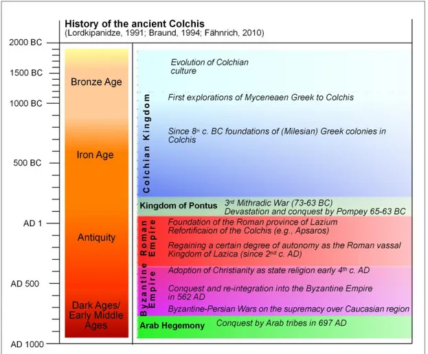
The Colchian culture formed a stable state at least since the 8
thcentury BC and enjoyed its acme between the 6
th-4
thcentury BC (Fig. 1.6). According to Xenophon (Anabasis, V, VI, 37) it was ruled by the Aeëtides' dynasty, that referred themselves to the mythological king Aeëtes (Braund 1994). Though the region had been known since Mycenaean Greeks' spo- radic explorations in the late 2
ndto early 1
stmillennium BC, intensive trade contact with the ancient Greek world did not evolve until Milesian Greeks founded several colonies from the 8
thcentury BC onwards along the Colchian coast. The most famous of these are Dioscurias
Fig. 1.6: Overview of the history of ancient Colchis (own design 2017).


![Fig. 1.4: Digital Elevation Model (DEM) of the research area (based on ALOS World 3D with 30 m resolution [AW3D30])](https://thumb-eu.123doks.com/thumbv2/1library_info/3682946.1505091/33.892.147.780.114.755/digital-elevation-model-research-based-alos-world-resolution.webp)