International Ocean Discovery Program Expedition 379 Preliminary Report
Amundsen Sea West Antarctic Ice Sheet History
Development and sensitivity of the West Antarctic Ice Sheet tested from drill records of the Amundsen Sea Embayment
18 January–20 March 2019
Karsten Gohl, Julia S. Wellner, Adam Klaus, and the Expedition 379 Scientists
May 2019
Core samples and the wider set of data from the science program covered in this report are under moratorium and accessible only to Science Party members until 23 August 2020.
This publication was prepared by the European Consortium for Ocean Research Drilling (ECORD) Science Operator (ESO) and Texas A&M University (TAMU) as an account of work performed under the International Ocean Discovery Program (IODP). Funding for IODP is provided by the following international partners:
National Science Foundation (NSF), United States
Ministry of Education, Culture, Sports, Science and Technology (MEXT), Japan European Consortium for Ocean Research Drilling (ECORD)
Ministry of Science and Technology (MOST), People’s Republic of China Korea Institute of Geoscience and Mineral Resources (KIGAM)
Australia-New Zealand IODP Consortium (ANZIC) Ministry of Earth Sciences (MoES), India
Coordination for Improvement of Higher Education Personnel (CAPES), Brazil
Portions of this work may have been published in whole or in part in other IODP documents or publications.
Disclaimer
Any opinions, findings, and conclusions or recommendations expressed in this publication are those of the author(s) and do not necessarily reflect the views of the participating agencies or TAMU.
Copyright
Except where otherwise noted, this work is licensed under the Creative Commons Attribution 4.0 International (CC BY 4.0) license (https://creativecommons.org/
licenses/by/4.0/). Unrestricted use, distribution, and reproduction are permitted, provided the original author and source are credited.
Citation
Gohl, K., Wellner, J.S., Klaus, A., and the Expedition 379 Scientists, 2019. Expedition 379 Preliminary Report:
Amundsen Sea West Antarctic Ice Sheet History. International Ocean Discovery Program.
https://doi.org/10.14379/iodp.pr.379.2019 ISSN
World Wide Web: 2372-9562
Expedition 379 participants Expedition 379 scientists
Karsten Gohl Co-Chief Scientist
Department of Geosciences
Alfred Wegener Institute Helmholtz—Center for Polar and Marine Research
Germany
karsten.gohl@awi.de Julia S. Wellner Co-Chief Scientist
Earth & Atmospheric Sciences University of Houston USA
jwellner@uh.edu Adam Klaus
Expedition Project Manager/Staff Scientist International Ocean Discovery Program Texas A&M University
USA
aklaus@iodp.tamu.edu Thorsten Bauersachs
Organic Geochemist/Geomicrobiologist Institute of Geosciences
Christian-Albrechts University Germany
thorsten.bauersachs@ifg.uni-kiel.de Steven M. Bohaty
Paleontologist (diatoms) Ocean and Earth Science
National Oceanography Centre Southampton University of Southampton
United Kingdom
S.Bohaty@noc.soton.ac.uk Margot Courtillat
Paleontologist (foraminifers)
Centre of Education and Research on Mediterranean Environments (CEFREM) Laboratory
University of Perpignan France
margot.courtillat@hotmail.com Ellen A. Cowan
Sedimentologist
Department of Geological and Environmental Sciences Appalachian State University
USA
cowanea@appstate.edu Mariana S.R. Esteves Sedimentologist
Centre for Arctic Gas Hydrate, Environment and Climate (CAGE)
The Arctic University of Norway—UiT Norway
mariana.esteves@uit.no
Marcelo A. De Lira Mota Palynologist
School of Geography, Earth and Environmental Sciences University of Birmingham
United Kingdom Also at:
Technological Institute of Micropaleontology University of Vale do Rio dos Sinos (UNISINOS) Brazil
mal546@bham.ac.uk John M. Fegyveresi
Physical Properties/Downhole Measurements Specialist Cold Regions Research and Engineering Laboratory (CRREL) Engineer Research and Development Center, US Army Corps USA
fegy.john@gmail.com Thomas Frederichs Paleomagnetist
Faculty of Geosciences University of Bremen Germany
frederichs@uni-bremen.de Liang Gao
Paleomagnetist
School of the Earth Sciences and Resources China University of Geosciences
China
lgao@cugb.edu.cn Anna Ruth Halberstadt Sedimentologist
Geosciences
University of Massachusetts-Amherst USA
ahalberstadt@umass.edu Claus-Dieter Hillenbrand Sedimentologist
British Antarctic Survey United Kingdom hilc@bas.ac.uk Keiji Horikawa Sedimentologist
University of Toyama
Graduate School of Science and Engineering for Research Japan
horikawa@sci.u-toyama.ac.jp Masao Iwai
Paleontologist (diatoms) Kochi University
Kochi Core Center (KCC)/Center for Advanced Marine Core Research
Japan
iwaim@kochi-u.ac.jp
Ji-Hoon Kim
Inorganic Geochemist
Petroleum and Marine Research Division
Korea Institute of Geoscience & Mineral Resources (KIGAM) Republic of Korea
save@kigam.re.kr Theresa M. King
Physical Properties/Downhole Measurement Specialist College of Marine Science
University of South Florida USA
theresaking@mail.usf.edu Johann P. Klages
Sedimentologist
Alfred Wegener Institute Helmholtz—Center for Polar and Marine Research
Germany
johann.klages@awi.de Sandra Passchier Sedimentologist
Earth and Environmental Studies Montclair State University USA
passchiers@mail.montclair.edu Michelle L. Penkrot
Physical Properties/Downhole Measurement Specialist Department of Geological Sciences
University of Florida USA
mpenkrot09@gmail.com Joseph G. Prebble
Palynologist
Paleontology Department GNS Science
New Zealand j.prebble@gns.cri.nz Waliur Rahaman Inorganic Geochemist
Cryosphere and Climate
National Centre for Antarctic and Ocean Research (NCAOR) India
waliur@ncaor.gov.in
Benedict T.I. Reinardy Sedimentologist
Institutionen för Naturgeografi Stockholm University
Sweden
benedict.reinardy@natgeo.su.se Johan Renaudie
Paleontologist (radiolarians) Museum fur Naturkunde
Leibniz-Institut fur Evolutions und Biodiversitätsforschung Germany
johan.renaudie@mfn.berlin Delaney E. Robinson
Sedimentologist
Earth & Atmospheric Sciences University of Houston USA
derobin3@central.uh.edu Reed P. Scherer
Paleontologist (diatoms)
Geology and Environmental Geosciences Northern Illinois University
USA
reed@niu.edu Christine S. Siddoway Sedimentologist
Department of Geology Colorado College USA
csiddoway@coloradocollege.edu Li Wu
Sedimentologist
State Key Laboratory of Marine Geology Tongji University
China
wuli@tongji.edu.cn 460743265@qq.com Masako Yamane
Physical Properties/Downhole Measurement Specialist Nagoya University
Institute for Space-Earth Environmental Research Japan
yamane@nendai.nagoya-u.ac.jp
Outreach and education
Vivien Cumming United Kingdom
viviencumming@gmail.com
Karen Romano Young USA
wrenyoung@gmail.com
Ice observers
J. Garry N. MacCaull Weather/Ice Observer
Canada
John L. Powell Weather/Ice Observer
Canada
Operational and technical staff
SIEM Offshore AS officials Jacob C. Robinson
Master of the Drilling Vessel
Mark Robinson Drilling Supervisor JRSO shipboard personnel and technical representatives
Elissa Barris
Marine Laboratory Specialist (temporary) Susan Boehm
Marine Laboratory Specialist Ty Cobb
Marine Laboratory Specialist Aaron De Loach
Assistant Laboratory Officer Tim Fulton
Senior Imaging Specialist Clayton Furman Logging Engineer Randy Gjesvold
Marine Instrument Specialist Sandra Herrmann
Assistant Laboratory Officer Michael Hodge
Marine Computer Specialist Jon Howell
Applications Developer Rhonda Kappler Publications Specialist Nicolette Lawler
Marine Laboratory Specialist
Chang Liu
Marine Laboratory Specialist Daniel Marone
Marine Laboratory Specialist Aaron Mechler
Marine Laboratory Specialist Michael Meiring
Drilling Engineer Stephen Midgley
Operations Superintendent William Mills
Laboratory Officer Beth Ann Novak
Marine Laboratory Specialist Catherine Smith
Curatorial Specialist Steven Thomas
Marine Computer Specialist Garrick Van Rensburg
Marine Instrumentation Specialist Hai (James) Zhao
Applications Developer
Abstract
The Amundsen Sea sector of Antarctica has long been consid- ered the most vulnerable part of the West Antarctic Ice Sheet (WAIS) because of the great water depth at the grounding line and the absence of substantial ice shelves. Glaciers in this configuration are thought to be susceptible to rapid or runaway retreat. Ice flow- ing into the Amundsen Sea Embayment is undergoing the most rapid changes of any sector of the Antarctic Ice Sheet outside the Antarctic Peninsula, including changes caused by substantial grounding-line retreat over recent decades, as observed from satel- lite data. Recent models suggest that a threshold leading to the col- lapse of WAIS in this sector may have been already crossed and that much of the ice sheet could be lost even under relatively moderate greenhouse gas emission scenarios.
Drill cores from the Amundsen Sea provide tests of several key questions about controls on ice sheet stability. The cores offer a di- rect record of glacial history offshore from a drainage basin that re- ceives ice exclusively from the WAIS, which allows clear comparisons between the WAIS history and low-latitude climate records. Today, warm Circumpolar Deep Water (CDW) is imping- ing onto the Amundsen Sea shelf and causing melting of the under- side of the WAIS in most places. Reconstructions of past CDW intrusions can assess the ties between warm water upwelling and large-scale changes in past grounding-line positions. Carrying out these reconstructions offshore from the drainage basin that cur- rently has the most substantial negative mass balance of ice any- where in Antarctica is thus of prime interest to future predictions.
The scientific objectives for this expedition are built on hypoth- eses about WAIS dynamics and related paleoenvironmental and pa- leoclimatic conditions. The main objectives are
1. To test the hypothesis that WAIS collapses occurred during the Neogene and Quaternary and, if so, when and under which envi- ronmental conditions;
2. To obtain ice-proximal records of ice sheet dynamics in the Amundsen Sea that correlate with global records of ice-volume changes and proxy records for atmospheric and ocean tempera- tures;
3. To study the stability of a marine-based WAIS margin and how warm deep-water incursions control its position on the shelf;
4. To find evidence for earliest major grounded WAIS advances onto the middle and outer shelf;
5. To test the hypothesis that the first major WAIS growth was re- lated to the uplift of the Marie Byrd Land dome.
International Ocean Discovery Program (IODP) Expedition 379 completed two very successful drill sites on the continental rise of the Amundsen Sea. Site U1532 is located on a large sediment drift, now called Resolution Drift, and penetrated to 794 m with 90% re- covery. We collected almost-continuous cores from the Pleistocene through the Pliocene and into the late Miocene. At Site U1533, we drilled 383 m (70% recovery) into the more condensed sequence at the lower flank of the same sediment drift. The cores of both sites contain unique records that will enable study of the cyclicity of ice sheet advance and retreat processes as well as bottom-water circu- lation and water mass changes. In particular, Site U1532 revealed a sequence of Pliocene sediments with an excellent paleomagnetic re- cord for high-resolution climate change studies of the previously sparsely sampled Pacific sector of the West Antarctic margin.
Despite the drilling success at these sites, the overall expedition experienced three unexpected difficulties that affected many of the scientific objectives:
1. The extensive sea ice on the continental shelf prevented us from drilling any of the proposed shelf sites.
2. The drill sites on the continental rise were in the path of numer- ous icebergs of various sizes that frequently forced us to pause drilling or leave the hole entirely as they approached the ship.
The overall downtime caused by approaching icebergs was 50%
of our time spent on site.
3. An unfortunate injury to a member of the ship's crew cut the ex- pedition short by one week.
Recovery of core on the continental rise at Sites U1532 and U1533 cannot be used to precisely indicate the position of ice or re- treat of the ice sheet on the shelf. However, these sediments con- tained in the cores offer a range of clues about past WAIS extent and retreat. At Sites U1532 and U1533, coarse-grained sediments inter- preted to be ice-rafted debris (IRD) were identified throughout all recovered time periods. A dominant feature of the cores is recorded by lithofacies cyclicity, which is interpreted to represent relatively warmer periods variably characterized by higher microfossil abun- dance, greater bioturbation, and higher counts of IRD alternating with colder periods characterized by dominantly gray laminated terrigenous muds. Initial comparison of these cycles to published records from the region suggests that the units interpreted as re- cords of warmer time intervals in the core tie to interglacial periods and the units interpreted as deposits of colder periods tie to glacial periods.
The cores from the two drill sites recovered sediments of purely terrigenous origin intercalated or mixed with pelagic or hemi- pelagic deposits. In particular, Site U1533, which is located near a deep-sea channel originating from the continental slope, contains graded sands and gravel transported downslope from the shelf to the abyssal plain. The channel is likely the path of such sediments transported downslope by turbidity currents or other sediment- gravity flows. The association of lithologic facies at both sites pre- dominantly reflects the interplay of downslope and contouritic sed- iment supply with occasional input of more pelagic sediment.
Despite the lack of cores from the shelf, our records from the conti- nental rise reveal the timing of glacial advances across the shelf and thus the existence of a continent-wide ice sheet in West Antarctica at least during longer time periods since the late Miocene.
Cores from both sites contain abundant coarse-grained sedi- ments and clasts of plutonic origin transported either by downslope processes or by ice rafting. If detailed provenance studies confirm our preliminary assessment that the origin of these samples is from the plutonic bedrock of Marie Byrd Land, their thermochronologi- cal record will potentially reveal timing and rates of denudation and erosion linked to crustal uplift. The chronostratigraphy of both sites enables the generation of a seismic sequence stratigraphy not only for the Amundsen Sea rise but also for the western Amundsen Sea along the Marie Byrd Land margin through a connecting network of seismic lines.
Introduction
For decades, the ice in the drainage basins flowing into the Amundsen Sea has been considered the most vulnerable part of the
West Antarctic Ice Sheet (WAIS) because of the great water depth at the grounding line and the lack of substantial buttressing ice shelves (Hughes, 1981). Glaciers in this configuration are thought to be susceptible to rapid or runaway retreat (Schoof, 2007). Ice flow- ing into the Amundsen Sea Embayment is undergoing the most rapid changes of any sector of the Antarctic Ice Sheet, including changes caused by substantial grounding line retreat over recent de- cades, as observed from satellite data (Milillo et al., 2019). Recent models suggest that a threshold leading to the collapse of WAIS in this sector may have been passed already (Joughin et al., 2014) and that much of the ice sheet could be lost even under relatively mod- erate greenhouse gas emission scenarios (DeConto and Pollard, 2016). Model projections are limited by lack of constraints in sev- eral areas, most notably in a lack of detailed reconstructions of gla- cial history.
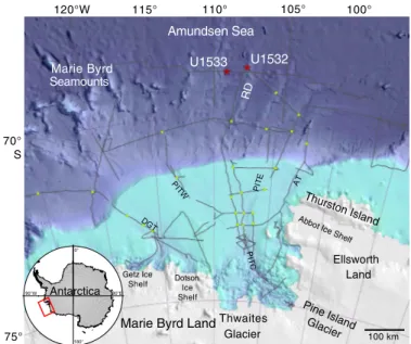
Drill cores from the Amundsen Sea (Figure F1) provide tests of several key questions about controls on ice sheet stability. First, the cores offer a direct record of glacial history in a drainage basin that receives ice only from the WAIS and thus allow clear comparisons between the WAIS history and low-latitude climate records. Ice draining into the Amundsen Sea is grounded below sea level and thus allows a test of the marine ice sheet instability theory through correlation of the ice sheet history to sea level changes. Although there are currently only relatively small ice shelves in front of the grounding line today, during some points of its history the embay- ment had more extended ice shelves (Kirshner et al., 2012; Klages et al., 2017) that allow examination of the grounding-line history rela- tive to the ice-shelf history. Today, warm Circumpolar Deep Water (CDW) impinges onto the Amundsen Sea shelf, which causes melt- ing of the underside of the ice in some places (Milillo et al., 2019).
Reconstructions of past CDW intrusions (Hillenbrand et al., 2017;
Minzoni et al., 2017) can assess the ties between warm water and large-scale changes in past grounding-line positions. Carrying out these reconstructions offshore from the drainage basin that cur- rently has the largest negative mass balance of ice of anywhere in Antarctica (Paolo et al., 2015) is thus of prime interest to future pre- dictions. Finally, Expedition 379 is part of a suite of Antarctic Inter- national Ocean Discovery Program (IODP) expeditions that allow large-scale reconstructions and comparisons between different drainage basins.
Background
The fourth assessment report of the Intergovernmental Panel on Climate Change (IPCC) (2007) highlighted the fact that the re- sponse of continental ice sheets to climatic changes and their con- tribution to global sea level change is the largest unknown variable in predicting future sea level change. The fifth and latest assessment report of the IPCC (2013) includes more information about the likely contributions to sea level change from the Antarctic, but these contributions remain one of the primary unknowns in predictions of future change. Also, the 2013 IPCC assessment report empha- sizes that if there is a substantial increase in the rate of sea level rise in the next century, it is likely to come from marine-based ice like that in the Amundsen Sea Embayment. The recent special report of the IPCC (2018) concludes that marine ice sheet instability in Ant- arctica and the irreversible loss of the Greenland ice sheet could be triggered by ~1.5° to 2°C of global warming and could result in mul- timeter sea level rise over hundreds to thousands of years.
The WAIS rests on a continental shelf that typically deepens to- ward the interior of the Antarctic continent. This fore-deepened
continental shelf, and thus the base of the ice, is mostly below sea level. Therefore, the marine-based WAIS is sensitive to global sea level rise and regional oceanographic and atmospheric changes, and its history has been highly dynamic (e.g., Joughin and Alley, 2011).
A complete WAIS collapse would raise the global sea level by 3.3 to 4.3 m (Fretwell et al., 2013), whereas the collapse of its Amundsen Sea drainage sector would raise the sea level by ~1.5 m (Vaughan, 2008). Over the most recent decades, glaciers draining into the Amundsen Sea thinned at a rapid rate, their flow speed dramatically increased, and their grounding lines retreated significantly, thereby contributing to present sea level rise at a faster rate than from any other glacier on Earth (e.g., Joughin and Alley, 2011; Joughin et al., 2012; Paolo et al., 2015; Rignot et al., 2019).
The present ice loss in the Amundsen Sea region is mainly at- tributed to sub–ice shelf melting induced by relatively warm CDW upwelling onto the shelf and spreading through deep bathymetric troughs toward the grounding zones (e.g., Arneborg et al., 2012;
Joughin et al., 2012). It is unclear, however, whether the current ice loss results from recent climatic/oceanographic warming or recent internal ice sheet dynamics (Joughin and Alley, 2011; Joughin et al., 2012). If the WAIS has undergone similar thinning and retreat in the past, the factors driving that retreat can be compared to modern conditions.
The reconstruction and quantification of WAIS collapse during the Neogene and Quaternary will provide constraints for ice sheet models (Figure F2) that predict future WAIS behavior and resulting sea level rise. Numerous modeling studies have tried to link the waxing and waning of the WAIS to various forcing mechanisms (e.g., Pollard and DeConto, 2009; Holden et al., 2010; DeConto and Pollard, 2016; Sutter et al., 2016). However, large uncertainties exist regarding the spatial and temporal variability of past ice sheet ad- vance and retreat. These uncertainties are mainly caused by the lack of data from cores drilled proximal to the WAIS. The only existing drill cores along the Pacific Antarctic margin outside the Ross Sea are from Deep Sea Drilling Project (DSDP) Leg 35 in the Belling- shausen Sea (Hollister and Craddock, 1976) and Ocean Drilling Program (ODP) Leg 178 on the Antarctic Peninsula margin (Barker and Camerlenghi, 2002). Results from Leg 178 Site 1097, drilled on the shelf, revealed a significant late Miocene change in sequence ge- ometry on the outer shelf that may indicate a change in the typical extent of glacial advances, the dynamic behavior of ice streams, or glacial sediment transport (Barker and Camerlenghi, 2002; Bart et al., 2005; Larter et al., 1997). Scheuer et al. (2006a, 2006b) was able to correlate seismic horizons with Leg 178 Sites 1095 and 1096 on the continental rise and interpreted transitions from preglacial to intermediate- and full-glacial conditions from the eastern Belling- shausen Sea to the Amundsen Sea.
The most detailed results on Neogene WAIS history stem from the Antarctic Geological Drilling (ANDRILL) project in the western Ross Sea, which recovered early Miocene (~20 Ma) to Quaternary sequences in Cores AND-1B (Naish et al., 2009) and AND-2A (Passchier et al., 2011). Pliocene data from Core AND-1B indicate that orbitally induced oscillations of the WAIS resulted in transi- tions from grounded ice or ice shelves to open-water conditions (Naish et al., 2009; McKay et al., 2012). However, previous seismic stratigraphic work on the Ross Sea shelf beyond Site AND-1B re- vealed only seven shelf-wide grounding events (Alonso et al., 1992).
Given the location of Site AND-1B, which is in a position to be over- ridden by both the East Antarctic Ice Sheet (EAIS) and the WAIS, the ANDRILL results are probably not representative of the WAIS outlets in the Amundsen, Bellingshausen, and Weddell Seas. Sedi-
mentary records from the Ross and Weddell Seas provide only an integrated archive of WAIS and EAIS dynamics, whereas records from the Amundsen Sea will provide an unambiguous WAIS signal.
We expect that results from recent IODP Expedition 374 to the Ross Sea shelf and slope will provide further insight into the WAIS dynamics for the Ross Sea sector. Although the Filchner-Ronne Ice Shelf extends far into the southern Weddell Sea, making grounding- line proximal positions difficult to access, only small and narrow ice shelves exist in the Amundsen Sea Embayment today.
Oceanographic setting
Persistent sea ice cover characterizes Pine Island Bay and the Amundsen Sea Embayment (e.g., Jacobs et al., 2012), and although sea ice cover has decreased significantly in recent decades (Parkin- son and Cavalieri, 2012), 2018 and 2019 did not follow this trend;
the sea ice cover of the Amundsen Sea was extensive throughout the entire austral summer and fall. Very little data on tidal ranges exist for the Amundsen Sea, but models suggest a 40 cm tidal height, making the area microtidal (Padman et al., 2002). Water mass tem- peratures within Pine Island Bay typically range between −1.5° and 0°C. The exception to this is warm CDW, which can reach 1.5°C and impinges onto the shelf through deep glacially carved troughs (Walker et al., 2007; Jacobs et al., 2011, 2013) and at times reaches into some of the smaller bays and fjords on the inner shelf (Minzoni et al., 2017). Productivity in the Amundsen Sea is among the highest in the Southern Ocean and includes phytoplankton blooms related to polynyas (Arrigo et al., 2008; Minzoni et al., 2017). CDW is widely considered to be the primary external driver of contempo- rary glacier retreat in the Amundsen Sea, and recent work has shown that it can vary on seasonal (Kim et al., 2017) to decadal (Jen- kins et al., 2016) timescales in response to wind stress at the conti- nental shelf edge.
Geological setting
Together, ice sheet dynamics and tectonic as well as other geo- logic processes have shaped the Amundsen Sea continental shelf and rise. A 500–700 m deep shelf is incised by two major paleo–ice stream troughs (Pine Island and Dotson-Getz) whose tributaries originate from ice-stream/glaciers on the innermost ultradeep (as deep as 1600 meters below sea level [mbsl]) shelf and converge at the transition from the inner to middle shelf. Both troughs extend toward the outer shelf, thereby becoming shallower and wider. The shelf geometry consists of a large pre- and synrift basin on the mid- shelf between the basement cropping out on the inner shelf and the buried basement highs on the outer shelf. A subordinate basin within the large midshelf basin may be associated with motion along an early West Antarctic Rift System branch. At least 4 km of preglacial strata were eroded by ice from the present inner shelf and coastal hinterland. At least five major erosional unconformities in- dicate phases of significant WAIS advances. Prograding sequences and subglacial bedforms on the outer shelf, subglacial tills recovered in cores, and radiocarbon dates on calcareous microfossils and or- ganic matter in overlying sediments indicate that ground ice ex- panded to the outer shelf during the LGM and earlier glacial periods.
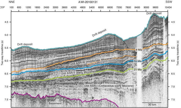
The continental rise is dominated by thick sedimentary depo- sition centers and by sediment drifts, both of which indicate strong bottom-current activity. Seismic data analysis from the Amundsen Sea rise reveals that sediment drift formation began in the Eo- cene/Oligocene (Uenzelmann-Neben and Gohl, 2012, 2014) (Figure F3). This observation indicates bottom-current activity and hence a
cold climate for the late Paleogene in the area that today probably lies under the influence of Antarctic Bottom Water originating in the Ross Sea. Seismic records from the continental rise along the entire Marie Byrd Land margin mark the base of the sediment drifts throughout the Amundsen Sea and into the Ross Sea (Lindeque et al., 2016a, 2016b). These records provide insight into the sedimen- tation processes from preglacial to glacial times, variations in bot- tom-water circulation, early ice sheet growth, and glacial intensification toward the present icehouse regime (Uenzelmann- Neben and Gohl, 2012, 2014). However, stratigraphic age estimates are derived from long-distance seismic correlation with the western Antarctic Peninsula margin and the Ross Sea margin and hamper this insight.
Seismic records from the Amundsen Sea shelf show dipping strata of the midshelf that are possibly of Cretaceous to Miocene age and buried by aggradational, less consolidated strata of presumed Pliocene–Pleistocene age (Lowe and Anderson, 2002; Gohl et al., 2013b). Preliminary results from a seabed drilling expedition place constraints on the Cretaceous sequences on top of the outcropping bedrock of the middle to inner shelf of Pine Island Bay (Gohl et al., 2017). Since the mid-Miocene, the outer shelf and slope have under- gone first progradational and then aggradational deposition (Nit- sche et al., 1997; Hochmuth and Gohl, 2013; Gohl et al., 2013b).
Several unconformities that possibly indicate phases of subglacial erosion and ice advance separate the dipping strata. Although most of the inner Amundsen Sea shelf is void of significant sedimentary cover (Lowe and Anderson, 2002; Graham et al., 2009; Gohl et al., 2013a, 2013b), a few small, shallow basins lie along its eastern bor- der (Uenzelmann-Neben et al., 2007) and in front of Pine Island Glacier (Nitsche et al., 2013; Muto et al., 2016).
A bathymetric and structural high (Nitsche et al., 2007; Gohl et al., 2013b) separates the eastern and western Amundsen Sea conti- nental shelves. Oceanward-dipping midshelf strata north of the out- cropping basement are evident in seismic data from the Dotson- Getz Trough (Wellner et al., 2001; Graham et al., 2009; Weigelt et al., 2009; Gohl et al., 2013b) and exhibit alternating sequences of low and high reflectivity that are interpreted to be Miocene epi- sodes of ice sheet advance and retreat. The glacial sequence strati- graphic model by Powell and Cooper (2002) proposed that glacial advances develop morainal banks consisting of unstratified diamic- ton, sand, and gravel that lead to a chaotic or semitransparent seis- mic reflection pattern. In contrast, stratified muds are deposited during a glacial retreat, which is expressed in seismic profiles as a succession of closely spaced continuous reflectors. Boundaries be- tween the acoustic units are sharp, but without drilling, the timing of ice sheet oscillations remains unconstrained. Similar seismic fa- cies occur on the Ross Sea and Antarctic Peninsula shelves, where drill cores confirmed that the chaotic/transparent units correspond to massive diamicton and acoustically stratified seismic facies cor- respond to distal glacimarine sediments (Anderson and Bartek, 1992; Bart and Anderson, 2000; Eyles et al., 2001).
The current seismostratigraphic model of the Amundsen Sea shelf was developed by long-distance correlation of seismic data with those of the Ross Sea shelf, which show striking similarities (Gohl et al., 2013b). Adopting the ages of the seismostratigraphic units and unconformities on the Ross Sea shelf, which are relatively well constrained by DSDP Leg 28 and ANDRILL records (e.g., De Santis et al., 1999; McKay et al., 2009), the shelf-basin formation model for the Amundsen Sea shows development from a Creta- ceous synrift basin to glacially dominated strata in the Neogene and Quaternary (Gohl et al., 2013b). The seismostratigraphic record
from the continental shelf is consistent with records from the Ross Sea (Bartek et al., 1991; Chow and Bart, 2003) and James Ross Basin in the northwestern Weddell Sea (Smith and Anderson, 2010), indi- cating a Miocene intensification of glaciation (De Santis et al., 1997) in accordance with findings from Core AND-2A (Warny et al., 2009;
Passchier et al., 2011) and the Shallow Scientific Drilling on the Antarctic Continental Margin (SHALDRIL)-II drill cores (Ander- son et al., 2011; Anderson and Wellner, 2011).
Apart from ice sheet dynamics inferred from the geometries and acoustic facies of seismic reflections, the ice-drainage pattern in the Amundsen Sea at the LGM and its substrate control were investi- gated by the analysis of sub- and proglacial bedforms visible in swath bathymetry surveys and acoustic subbottom profiler data (e.g., Larter et al., 2009). The subglacial bedforms on the shelf indi- cate that grounded ice expanded to the outer shelf or even the shelf edge during the recent past (Wellner et al., 2001; Lowe and Ander- son, 2002; Graham et al., 2009, 2010; Jakobsson et al., 2012; Nitsche et al., 2013). Analysis of subglacial and glacimarine sediments re- covered in cores from the continental shelf confirmed an LGM age for the last WAIS advance, allowed a reconstruction of its retreat history (Lowe and Anderson, 2002; Smith et al., 2011, 2014; Kirsh- ner et al., 2012; Hillenbrand et al., 2013; Larter et al., 2014), and in- dicated dynamically evolving drainage systems (Ehrmann et al., 2011). Recently, studies of benthic foraminiferal assemblages (Minzoni et al., 2017) and the chemical composition (i.e., stable car- bon isotopes and magnesium/calcium ratios) of benthic and plank- tonic foraminifer shells in ice-proximal marine sediments from the inner shelf (Hillenbrand et al., 2017) showed that variable inflow of CDW was the primary driver for grounding-line retreat along the coast of the Amundsen Sea Embayment throughout the Holocene and since the 1940s. Sedimentary sequences from the Amundsen Sea continental slope and rise spanning glacial–interglacial cycles to 1.8 Ma were investigated by multiproxy analyses to find evidence for or against a WAIS collapse during the Quaternary (Hillenbrand et al., 2002, 2009; Konfirst et al., 2012), as was previously suggested (e.g., Scherer et al., 1998; Scherer, 2003). One of these studies found a mid-Pleistocene depositional anomaly that may indicate a WAIS collapse between 621 and 478 ky ago (Hillenbrand et al., 2009). All of these studies provide a robust sedimentological framework for interpreting drill cores.
Objectives
The scientific goals and plan for this expedition are built on five hypotheses about WAIS dynamics and related paleoenvironmental and paleoclimatic conditions.
Hypothesis H1: the WAIS responded to atmospheric and oceanic warming by a major retreat from the shelf or by even partial to full collapse.
Ice sheet models hypothesize that past climate warming caused significant deglaciation of the WAIS (e.g., DeConto and Pollard, 2016). For instance, during the early middle Pliocene, Earth’s cli- mate was ~3°C warmer than at present (e.g., Haywood et al., 2009) and thus as warm as predicted for the end of this century, although atmospheric pCO2 was ~400 ppm and other climatic boundary con- ditions were similar to the present (Pagani et al., 2010). The reasons for such a high atmospheric temperature during a time with modest greenhouse-gas forcing are still unknown. Results from Core AND- 1B suggest repeated WAIS collapses during warm early middle Plio- cene and Pleistocene interglacials (e.g., during Marine Isotope Stage
[MIS] 31) (Naish et al., 2009; Pollard and DeConto, 2009; McKay et al., 2012; Villa et al., 2012). The hypothesis of WAIS collapses needs confirmation with a less ambiguous record from an outlet drainage basin exclusively affected by the WAIS. In drill cores from the Amundsen Sea margin, WAIS collapses would be recognizable by biogenic sedimentary sequences deposited during times with per- manent open-water conditions and reduced supply of glacigenic de- bris from the West Antarctic hinterland similar to those documented in the Core AND-1B record (Naish et al., 2009). Such sediments would contain abundant microfossils and probably tephra layers from the Marie Byrd Land volcanic province (e.g., Le Masurier and Rex, 1991; Wilch et al., 1999), which are essential for dating the sediments and reconstructing paleoenvironmental con- ditions in the region. Thus, the cores will help to answer the crucial question: did the WAIS collapse during the Neogene and Quater- nary, as previously suggested, and if yes, when and under which en- vironmental conditions?
Hypothesis H2: ice-proximal records of ice sheet dynamics in the Amundsen Sea correlate with global records of ice-volume changes and proxy records for atmospheric and ocean temperatures.
The post-LGM retreat of the WAIS from the Amundsen Sea shelf was episodic (e.g., Lowe and Anderson, 2002; Graham et al., 2009, 2010; Jakobsson et al., 2012; Larter et al., 2014). The retreat episodes were likely triggered by different processes, including sea level rise, sub–ice shelf erosion by warm deep-water advection, de- stabilization of the ice sheet by subglacial meltwater outbursts, and grounding-line retreat into overdeepened inner-shelf basins (Ja- kobsson et al., 2011; Smith et al., 2011, 2014; Kirshner et al., 2012;
Hillenbrand et al., 2013, 2017). These observations raise questions concerning the linkage between climate and glaciological forcing in regulating WAIS deglaciation. Throughout the Cenozoic era, unex- plained discrepancies are observed between Earth’s temperature and global ice volume reconstructed from proxies in deep-sea sedi- ments, climate models, sea level estimates, and ice cores for the last 800 ky. Reexamination of previously studied cores highlights ongo- ing uncertainty about the timing of early ice sheet growth (Carter et al., 2017). The results of the Core AND-1B record (Naish et al., 2009) and Integrated Ocean Drilling Program Expedition 318 to the Wilkes Land margin (Cook et al., 2013) reignited the debate as to whether the Antarctic ice sheets underwent major collapses during Pliocene interglacials. Such collapses are neither directly recogniz- able from oxygen isotope proxies at far-field sites nor confirmed by the apparently persistent glaciation of the Antarctic Peninsula since the latest Miocene (Smellie et al., 2009) and repeated Pliocene ice sheet advances across the shelf that are observed in seismic profiles all along the Antarctic margin (e.g., Larter et al., 1997; Nitsche et al., 1997; Bart and Anderson, 2000; Smith and Anderson, 2010; Bart, 2001). Indeed, results from SHALDRIL cores and other data from the eastern Antarctic Peninsula shelf indicate gradual cooling and an associated decline in vegetation over the past 37 My culminating in early Pliocene ice sheet expansion onto the continental shelf (An- derson et al., 2011). Results from ODP Leg 178 cores from the west- ern Antarctic Peninsula margin are consistent with repeated ice sheet advances throughout the Pliocene (Eyles et al., 2001; Hillen- brand and Ehrmann, 2005; Hepp et al., 2006; Bart, 2001) but also indicate significant oceanic warming during Pliocene interglacials (Hillenbrand and Cortese, 2006; Escutia et al., 2009; Hepp et al., 2009; Bart and Iwai, 2012). Expedition 379 drill sites will help us de- cipher whether the WAIS responded directly to the orbitally paced climatic cycles of the Pliocene and Quaternary or varied at periods
determined by its internal dynamics, as findings from Leg 178 sug- gest for the Antarctic Peninsula Ice Sheet (Barker and Camerlenghi, 2002). Similar to cores from the Ross Sea and Antarctic Peninsula shelves (Eyles et al., 2001; McKay et al., 2009), the Leg 178 cores are incomplete because of glacial erosional unconformities. During Ex- pedition 379, cores were drilled from deep-sea drifts on the conti- nental rise of the Amundsen Sea Embayment to obtain complete sedimentary sequences. Similar drift sediments drilled on the west- ern Antarctic Peninsula continental rise during Leg 178 provided excellent archives of Neogene to Quaternary ice sheet dynamics and paleoenvironmental changes (e.g., Hillenbrand and Ehrmann, 2005;
Cowan et al., 2008; Hepp et al., 2006, 2009; Escutia et al., 2009; Bart and Iwai, 2012). A comparable potential has already been demon- strated for Pleistocene drift sediments recovered from the Amund- sen Sea continental rise (Hillenbrand et al., 2009).
Hypothesis H3: the stability of marine-based WAIS margins is and has been controlled by warm deep-water incursions onto the shelf.
In model experiments, incursions of relatively warm CDW onto the West Antarctic continental shelf have been implicated in regu- lating WAIS behavior on orbital and suborbital timescales (Thoma et al., 2008; Pollard and DeConto, 2009; Jenkins et al., 2016). There- fore, records of past CDW upwelling are urgently needed to under- stand the relationship between WAIS dynamics and ocean circulation. Generating proxy records of past CDW incursions from marine sediment cores is still a challenge but was recently demon- strated to be possible in sediments from the Amundsen Sea Embay- ment shelf (Hillenbrand et al., 2017; Minzoni et al., 2017). With recent observations of present CDW advection predominantly through the paleo–ice stream troughs of the Amundsen Sea (e.g., Arneborg et al., 2012), drilling on the continental shelf has a good chance to recover sample material suitable for applying benthic for- aminifer–based and other proxies to reconstruct past CDW upwell- ing onto the shelf and its effect on WAIS dynamics.
Hypothesis H4: major WAIS advances onto the middle and outer shelf have occurred since the middle Miocene.
Seismic data revealed progradational and aggradational depo- sition on the outer shelf and slope of the Amundsen Sea probably since the mid-Miocene (e.g., Nitsche et al., 1997, 2000; Hochmuth and Gohl, 2013; Gohl et al., 2013b). Numerous unconformities within strata on the shelf document frequent advance and retreat of grounded ice from the late Miocene until the Pliocene/Pleistocene, according to the stratigraphic age model by Gohl et al. (2013b). The preservation of buried grounding-zone wedges in the Pliocene/Pleis- tocene sequence on the outer Amundsen Sea shelf is consistent with the prolonged continuous accumulation of marine and glacimarine sediments in an open-marine setting, probably during a long inter- glacial period with a significantly reduced WAIS, as observed on the Ross Sea shelf during the early Pliocene. However, the models of grounded-ice advance and retreat across the Amundsen Sea shelf are based on long-distance correlations of seismic facies and character- istics, which are tested by core data to constrain past WAIS extent.
Hypothesis H5: the first WAIS advance onto the inner Amundsen Sea continental shelf occurred during the Oligocene and was related to the uplift of Marie Byrd Land.
The onset of major glaciation in West Antarctica is still not dated because of sparse drill cores. Records of IRD suggest that gla-
ciers must have reached the coast of the Ross Sea in the early to mid-Oligocene (Miller et al., 2008). Ice sheet models (e.g., DeConto and Pollard, 2003) reconstructed an early WAIS nucleus in the mountain chain extending from elevated Marie Byrd Land over the Ellsworth Mountains to the southern Antarctic Peninsula. The ex- humation and erosion history of Marie Byrd Land and especially the Marie Byrd Land dome is essential for the interrelations between ice sheet and lithosphere dynamics (e.g., Rocchi et al., 2006; Wilson and Luyendyk, 2009; Wilson et al., 2012, 2013; Spiegel et al., 2016) be- cause (1) exhumation and erosion change topography, which in turn influences glacier movements by slope steepness; (2) exhumation is often associated with surface uplift, and high altitude favors forma- tion of glaciers; and (3) glaciation changes erosion rates and, be- cause of isostatic adjustment, exhumation rates. This relationship is investigated using detailed provenance and thermochronological analyses of Neogene drill samples from the midshelf and existing rock samples from the hinterland.
Operations plan/drilling strategy
The primary aim of our drilling campaign was to obtain core and log data from seaward-dipping strata along a transect from the Paleo- gene sequences close to the boundary with bedrock on the inner shelf to the Pliocene to Pleistocene sequences on the outer shelf and con- tinuing onto the continental rise for continuous high-resolution re- cords. Because sea ice conditions during the drilling expedition were unsuitable for accessing either the priority sites in Pine Island Trough or the transect targeting strata of comparable age and cross-shelf po- sition in the Dotson-Getz Trough, a paleo–ice stream trough of the western Amundsen Sea Embayment, we drilled our third-tier priority sites on the continental rise. The sites we drilled during Expedition 379 were added to the proposal following the record sea ice in the 2017/2018 austral summer. The two sites (U1532 and U1533) were not lower in priority than other rise sites; instead, they were added to the proposal in 2018 when sites were no longer required to be on a crossing seismic line. This change provided an opportunity for alter- nates even farther north, and thus farther from likely sea ice cover than the originally proposed sites. Additional modifications in 2018 to our original proposal included approval of “ribbons” along the seis- mic line that allowed holes to be drilled in a range of positions and for maximum flexibility in severe ice conditions.
Our plan was to core two holes at each drill site using the ad- vanced piston corer (APC), half-length advanced piston corer (HLAPC), and extended core barrel (XCB) system in the first hole and the rotary core barrel (RCB) system in the second hole and then collect log data in the deeper RCB hole. In reality, each of our two drill sites included far more holes than intended. Site U1532 in- cludes seven holes, and Site U1533 has four holes. No holes were terminated by reaching target depths; we terminated the first 10 holes because of approaching icebergs, and we had to abandon the final hole because of an emergency medical evacuation.
The coring strategy at each site generally followed the opera- tional plans; however, it was spread out over multiple holes. When we were forced to leave a hole, we drilled a new hole without coring through the upper section, and then coring resumed with some overlap. We initiated new holes following a standard offset of 20 m except when ice conditions would not allow a new hole close to the original site and other positions along the permitted ribbon were open. Thus, the holes at each site are more spread out than those of many other IODP expeditions.
Although downhole logging was planned for each site, no down- hole log data were collected during Expedition 379 because of the premature termination of each hole.
Site summaries Site U1532
Background
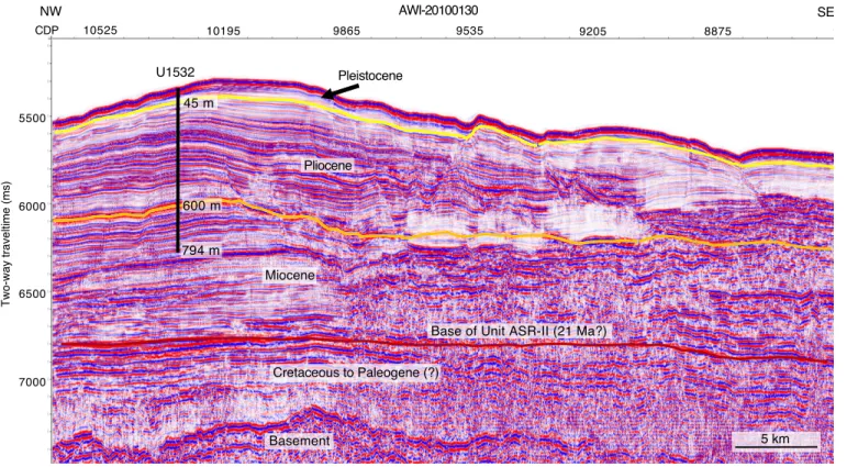
Site U1532 (proposed Site ASRE-08A) is located on the western upper flank of a large sediment drift (Resolution Drift) on the conti- nental rise, 270 km north of the Amundsen Sea Embayment shelf edge (Figures F1, F4). This drill site was chosen as the first Expedi- tion 379 site upon arriving in the Amundsen Sea because the sea ice distribution did not allow drilling at any of the other primary or al- ternate sites at that time. The Resolution Drift belongs to a system of five parallel sediment drifts on this rise that are characterized by gentle western and steep eastern flanks. Sediment drifts are com- monly formed by deposition of suspended sediments transported by ocean-bottom contour currents. Deep-sea channels that origi- nate at the foot of the continental slope and reach far into the abys- sal plain separate the sediment drifts in the Amundsen Sea.
Sediment is transported downslope through these channels by tur- bidity currents, slumps, and other gravity-driven processes that supply a large portion of the detritus deposited in the drifts (Nitsche et al., 2000; Dowdeswell et al., 2006). Sedimentation rates of drift deposits along the Antarctic margin are extremely high, which makes them high-priority drill targets to obtain continuous pale- oceanographic and paleo–ice sheet records of high temporal resolu- tion (Uenzelmann-Neben and Gohl, 2012). Stratigraphic interpretations of seismic lines across the sediment drifts of the Amundsen Sea (e.g., Nitsche et al., 2000; Scheuer et al., 2006b; Uen- zelmann-Neben and Gohl, 2012, 2014) are so far only constrained by long-distance correlation with drilled records of drift deposits on the Antarctic Peninsula rise (Leg 178; e.g., Acton et al., 2002). How- ever, the interpretations suggest equally high sedimentation rates for the Pleistocene, Pliocene, and upper Miocene.
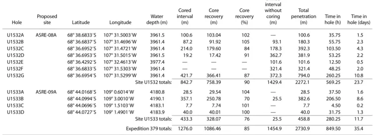
Seven holes (U1532A–U1532G) were drilled in 3962 m water depth (Figure F5). The deepest hole (U1532G) was drilled to 794 m.
Overall core recovery was 90%. Although sea ice was not a problem for the R/V JOIDES Resolution at this site, icebergs of various sizes, from large tabular icebergs to smaller fragments and growlers, fre- quently approached the ship and were the primary reason for the large number of holes. Holes U1532E and U1532F were nothing more than unsuccessful attempts to start coring at depth before be- ing forced to avoid another approaching iceberg.
Lithostratigraphy
Deposits recovered at Site U1532 include silty clay with dis- persed sand and gravel and variable biogenic content from five holes down to a recovered core depth of 787.4 m. Six lithofacies were identified based on visual characteristics of the sediments combined with information from smear slides and thin sections.
Whole-core X-radiographs aided in observations of sedimentary structures, clast occurrence, and drilling disturbance. The domi- nant lithofacies assemblages are planar thinly laminated silty clay with episodic occurrences of massive and bioturbated silty clay typ- ically <1.5 m thick. We observed dispersed sand grains, granules, and occasional pebbles throughout the assemblages, but they ap- pear mainly concentrated within the massive and bioturbated fa- cies. Minor lithofacies include foraminifer-rich and biosiliceous- rich mud to ooze.
We identified one lithostratigraphic unit with three subunits based on changes in facies assemblages: Subunits IA (0–92.6 m;
Pleistocene–Pliocene), IB (92.6–400.6 m; Pliocene), and IC (401.0–
787.4 m; Pliocene–Miocene). The sediments are mostly unconsoli- dated in the upper 150 m and become increasingly more consoli- dated below this depth. Intervals of carbonate-cemented laminae and very thin beds of coarse siltstone and sandstone are present deeper than 400 m.
Biostratigraphy
In the upper part of the section recovered at Site U1532 (i.e., Subunit IA; 0–92 m), sufficient microfossils for biostratigraphic age assignment were only present in the upper ~10 m, providing an age of middle Pleistocene to recent (0.0–0.6 Ma). Based on diatom and radiolarian biostratigraphy, ~92–156 m is assigned a mid- to late Pliocene age of 3.2–3.8 Ma and ~156–224 m is assigned an early Pliocene age of 3.8–4.4 Ma. The absence of microfossils or only trace occurrences of highly fragmented and recrystallized siliceous microfossils in samples deeper than ~224 m in Hole U1532G pre- cluded shipboard biostratigraphic age determination at most levels.
Exceptions include short intervals with poorly preserved but identi- fiable diatoms between ~224 and 332 m (early Pliocene; <4.7 Ma) and between ~332 and 510 m (early Pliocene to near the Mio- cene/Pliocene boundary; <5.5 Ma).
Some light green, biosiliceous-rich intervals coincide with higher concentrations of coarse sand and gravel, which are inferred to be IRD, and are generally bioturbated. Other intervals that were sampled based on their lower density than the laminated silty clay(stone) have a greenish color and show evidence of bioturbation but lack identifiable biosiliceous material, which we infer, at least in part, to reflect a diagenetic loss of diatoms and other siliceous microfossils. Organic microfossils occur throughout the Site U1532 sequence. A possibly in situ dinoflagellate cyst (dinocyst) assem- blage of very low diversity and low abundance is present throughout the section but is most persistent deeper than 591.77 m. Calcareous microfossils including foraminifers, calcareous nannofossils, and ostracods generally occur in the absence of biosiliceous material in thin intervals in the Pleistocene section.
Paleomagnetism
The interpreted magnetic polarity at Site U1532 was correlated with the Geomagnetic Polarity Timescale (GPTS) of Gradstein et al.
(2012). The resulting key paleomagnetic data were then integrated with biostratigraphic data to produce an age model.
For Hole U1532A, we obtained reliable shipboard magneto- stratigraphy that consists of four normal and four reversed polarity intervals. The Brunhes–Matuyama polarity transition (0.781 Ma), the termination and beginning of the Olduvai Subchron (1.778 and 1.945 Ma, respectively), the Matuyama–Gauss polarity transition (2.581 Ma), the termination and beginning of the Kaena Subchron (C2An.1r; 3.032 and 3.116 Ma, respectively), and the termination and beginning of the Mammoth Subchron (C2An.2r; 3.207 and 3.330 Ma, respectively) were identified. Paleomagnetic measure- ments for Hole U1532B identified the beginning of the Mammoth Subchron (C2An.2r; 3.330 Ma) and the Gauss–Gilbert polarity transition (3.596 Ma). Paleomagnetic measurements for Hole U1532C identified the termination of the Nunivak Subchron (C3n.2n; 4.493 Ma) but no clear Cochiti Subchron (C3n.1n; 4.187–
4.300 Ma). Natural remanent magnetization (NRM) measurements for Hole U1532G identified the beginning of the Nunivak Subchron (C3n.2n; 4.631 Ma), the termination and beginning of the Sidufjall
Subchron (C3n.3n; 4.799 and 4.896 Ma, respectively), and the ter- mination and beginning of the Thvera Subchron (C3n.4n; 4.997 and 5.235 Ma, respectively). Reversed magnetic polarity continues downhole to the bottom of Hole U1532G. The beginning of Chron C3r (6.033 Ma) was not observed. Therefore, the oldest sediments recovered at Site U1532 are presumably of late Miocene age.
Geochemistry
At Site U1532, 65 interstitial water samples were collected and measured for salinity, alkalinity, pH, major ions (Na, K, Ca, Cl, and SO4), nutrients (NH4 and PO4), silica (H4Si(OH)4), and trace ele- ments (Sr, Li, Fe, Mn, B, and Ba). Drilling fluid contamination was detected in a few interstitial water samples taken from XCB cores.
Higher abundances of perfluorocarbon tracer in these samples are in line with this observation. The SO4 downhole profile shows a sharp linear decrease from ~28 mM near the surface to ~2.3 mM at
~664 m; however, SO4 concentration did not reach zero at this site, indicating a low SO4 reduction rate. The Ca and Sr profiles show an overall increase, whereas the K and Mg profiles display the reverse trend. Silica concentration is relatively high from 8.5 to 238 m, coin- ciding with intervals where a higher abundance of diatoms was ob- served. Diagenesis of diatoms through reaction with the interstitial water likely results in higher silicaconcentration.
Calcium carbonate (CaCO3) content is low in the sediments of Lithostratigraphic Subunit IA; discrete maxima in CaCO3 observed in the upper section of Subunit IA are linked to layers rich in calcar- eous foraminifer tests. Subunit IB is characterized by a general in- crease in CaCO3 downhole. Total organic carbon (TOC) content is generally low at Site U1532 but displays a stepwise increase from Subunit IA to Subunit IC. Total nitrogen content is low throughout all subunits. Total sulfur (TS) content decreases throughout Subunit IA and generally remains low throughout Subunit IB. TS displays a downhole increase in the uppermost section of Subunit IC (to ~533 m). Deeper than ~533 m, TS declines again and then shifts to low values deeper than ~670 m. This shift in TS content is associated with a near depletion of interstitial water sulfate concentrations, which may limit sulfate reduction.
Headspace gas samples to monitor for the presence and abun- dance of C1–C3 hydrocarbons indicate that methane occurs in only very low concentrations throughout the upper ~650 m. At ~667 m, methane concentration increases rapidly, exceeding 5000 ppmv deeper than ~713 m and reaching a maximum of 9517 ppmv at
~771 m. The increase of methane at ~667 m coincides with a pro- nounced minimum in sulfate, suggesting that methane may be bio- genic at Site U1532.
Physical properties
Collected physical property data include magnetic susceptibil- ity, natural gamma radiation (NGR), gamma ray attenuation (GRA) bulk density, discrete moisture and density (MAD), P-wave velocity, thermal conductivity, in situ formation temperature (advanced pis- ton corer temperature tool [APCT-3]), and spectral color reflec- tance. Whole-round magnetic susceptibility trends follow those observed in GRA bulk density and NGR, likely indicating changes in terrigenous sediment content. Magnetic susceptibility data were used as a primary tool for correlating cores from adjacent holes. In the upper 65 m, bulk density increases downhole from ~1.5 to ~1.8 g/cm3, followed by a more gradual increase to ~2.2 g/cm3 in the deeper section, reflecting increasing compaction. Intervals of sig- nificantly lower density correspond to greenish gray intervals in Lithostratigraphic Subunits IB and IC. Sediment porosity decreases
downhole from 77% at the seafloor to 60% at 30 m and decreases further with depth to 35% at the bottom of Hole U1532G, reflecting the downward compaction trend of marine sediments. P-wave ve- locity increases with depth from ~1460 m/s at the seafloor to ~2000 m/s at the base of Hole U1532G. No major changes in P-wave veloc- ity were observed across the lithostratigraphic subunit boundaries.
Overall, thermal conductivity increases with depth from ~1 W/(m·K) at the seafloor to ~1.8 W/(m·K) at ~390 m, corresponding to a downhole increase in dry bulk density and decrease in porosity because of compaction. Formation temperature measurements from 34.0 to 150.0 m in Hole U1532A were used to estimate a geo- thermal gradient of ~54˚C/km.
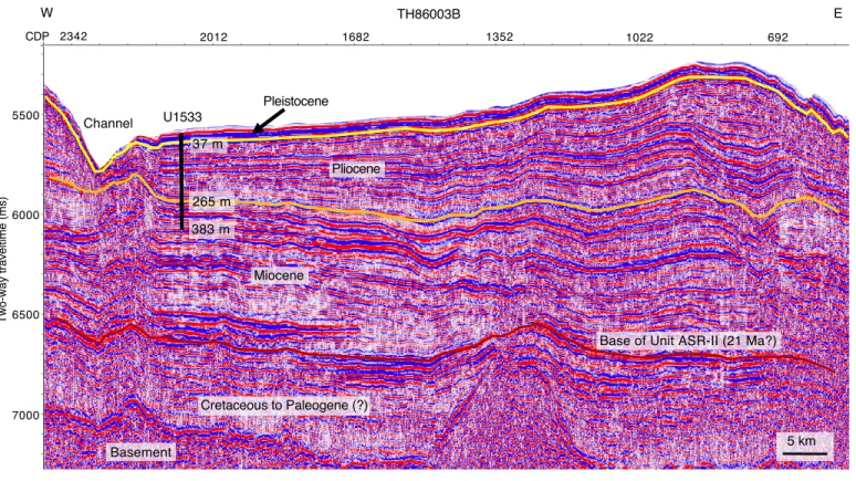
Site U1533
Background
Site U1533 (proposed Site ASRE-09A) is located 62 km west- southwest of Site U1532 on the westernmost lower flank of Resolu- tion Drift, the same sediment drift as Site U1532, on the continental rise of the Amundsen Sea (Figures F1, F6). This lower flank is bound by a north-south–oriented deep-sea channel west of Site U1533 (Uenzelmann-Neben and Gohl, 2012). The channel is likely the path of sediment transported downslope from the shelf by tur- bidity currents and sediment gravity flows and, as such, is likely the major source of terrigenous sediment to the drill site (e.g., Dowde- swell et al., 2006). Bottom currents transported clay- and silt-sized particles before they deposited them to form a drift (e.g., Nitsche et al., 2000). A robust horizon correlation from Site U1532 was per- formed along three connected seismic lines, indicating that sedi- mentary sequences of the same age are more condensed at Site U1533.
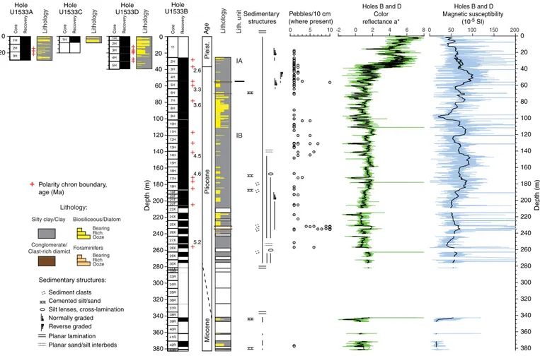
Four holes (U1533A–U1533D) were drilled at Site U1533 in wa- ter depths between 4179 and 4184 m (Figure F7). The deepest pen- etration (Hole U1533B) reached 383 m with an overall core recovery of 70%. As at Site U1532, frequent approaches of icebergs of various sizes were the primary reason for the large number of holes.
Lithostratigraphy
Sediments recovered at Site U1533 consist mainly of silty clay with varying biogenic content and amounts of bioturbation as well as rare occurrences of diamict and conglomerate. Thin sand and silt beds and laminae occur throughout, and intervals of carbonate ce- mentation and volcaniclastic material were also observed. The re- covered sediments are categorized into seven lithofacies based on visual characteristics and lithologic information supported by smear slide observations. The drilled sequence is divided into Lithostratigraphic Subunits IA and IB based on changes in facies as- semblages. Whole-core X-radiographs were used to aid in the iden- tification of sedimentary structures, clast occurrence, and drilling disturbance. Site U1533 is dominated by deposition of fine-grained sediments interpreted to be initially supplied by sediment gravity flows from the continental shelf and subsequently reworked by con- tour currents. Silt and sand beds are interpreted to have been de- posited by overspill of turbidity currents from the submarine channel. Additionally, a significant amount of biosiliceous material in the sediments is supplied from the overlying surface waters.
The association of facies in Lithostratigraphic Subunit IA pre- dominantly reflects the interplay of downslope and contouritic sed- iment supply that also includes input of more pelagic sediment during phases of seasonally open marine conditions. The amount of biogenic material is generally high throughout Subunit IA, suggest- ing relatively sustained periods of high marine productivity. Depos-
its related to downslope transport are present throughout the sedimentary record at Site U1533. In Subunits IA and IB, coarse- grained beds probably indicate that overspill deposition originated from downslope transport through the adjacent deep-sea channel.
Subunit IB has generally higher amounts of visible clasts and peb- bles than Subunit IA. Dispersed granules and pebbles, clast nests, and discontinuous bands of coarse sand and granules in Subunits IA and IB are inferred to indicate persistent but likely low-intensity ice rafting, and there is a higher abundance of this IRD within diatom ooze intervals.
Biostratigraphy
In contrast with Site U1532, which contains significant intervals that are barren of microfossils, the majority of Site U1533 samples from the mudline to the lowermost sediments contain microfossils.
Preservation and abundance of microfossils are highly variable, in- cluding some barren intervals noted in the uppermost Pliocene–
lowermost Pleistocene and lower Pliocene sections. A similar gen- eral pattern of alternating gray-beige to brownish sediments (Litho- stratigraphic Subunit IA) and gray-beige to greenish sediments (Subunit IB) at Site U1532 was commonly observed at Site U1533 and consisted of gray, laminated, microfossil-poor, mostly terri- genous mudstones punctuated by thinner brownish to greenish bio- turbated, variably biosilica-bearing intervals, some with sand to pebble-sized material interpreted to be IRD. However, the brownish and greenish bioturbated units have a higher overall concentration of biosiliceous material than at Site U1532.
The upper ~40 m of Site U1533 spans the Pleistocene and con- tains variable concentrations of diatoms, radiolarians, and foramin- ifers; rare marine and reworked terrestrial palynomorphs; and very rare calcareous nannofossils. Diatoms and radiolarians are present in most samples examined from this interval. Foraminifers are pres- ent only in a few intervals in the upper ~10 m of the sequence.
Pleistocene to upper Miocene sediments recovered from Hole U1533B are dated primarily by diatoms and radiolarians. Both are documented with variable abundance from the top to the bottom of Hole U1533B. Samples from the lowermost cores generally contain common to abundant diatoms, although the assemblages are highly fragmented. Diatoms and radiolarians provide a latest Miocene age (6.2–6.7 Ma) for the lowermost sediments recovered from Hole U1533B; combined with magnetostratigraphic constraints, the deepest sediments recovered in Hole U1533B are ~6.4–6.75 Ma.
Foraminifers and calcareous nannofossils were not observed in the Pliocene sediments in Hole U1533B, whereas rare to common ma- rine and reworked terrestrial palynomorphs are present throughout the hole.
Paleomagnetism
For Hole U1533A, demagnetization of NRM at 20 mT identifies the Brunhes–Matuyama transition (0.781 Ma), the termination and beginning of the Jaramillo Subchron (C1r.1n; 0.988 and 1.072 Ma, respectively), and the termination and beginning of the Cobb Mountain Subchron (C1r.2n; 1.173 and 1.185 Ma, respectively).
The magnetostratigraphy for Hole U1533B is more complex than for Hole U1533A because of reduced core recovery and drill- ing disturbance of some intervals. The shipboard interpretation identifies the beginning of the Olduvai Subchron (C2n; 1.945 Ma), the termination and beginning of Subchron C2An.1n (2.581 and 3.032 Ma, respectively), the termination and beginning of Subchron C2An.3n (3.330 and 3.596 Ma, respectively), the termination and beginning of the Cochiti Subchron (C3n.1n; 4.187 and 4.300 Ma, re-
spectively), and the termination and beginning of the Nunivak Sub- chron (C3n.2n; 4.493 and 4.631 Ma, respectively). Subchron C2An.2n (3.116–3.207 Ma) might be present in a very condensed form in Core 379-U1533B-5H at ~58 m. Further downhole, paleo- magnetic measurements reveal the termination and beginning of the Sidufjall Subchron (C3n.3n; 4.799 and 4.896 Ma, respectively) and the termination and beginning of the Thvera Subchron (C3n.4n; 4.997 and 5.235 Ma, respectively). Below an interval with- out core recovery, the oldest cores, 39R and 43R, are of mainly nor- mal polarity, suggesting a bottom age for Hole U1533B between the termination of Subchron C3An.1n (6.033 Ma) and the beginning of Subchron C3An.2n (6.733 Ma). Oscillating normal and reversed po- larity at the bottom of Hole U1533B provides no clear evidence that Subchron C3Ar was recovered.
For Hole U1533C, no magnetic polarity reversal was recorded, suggesting that the recovered sediments are younger than the Brun- hes–Matuyma transition (0.781 Ma).
For Hole U1533D, paleomagnetic measurements identified the Brunhes–Matuyama transition (0.781 Ma), the termination and be- ginning of the Jaramillo Subchron (C1r.1n; 0.988 and 1.072 Ma, re- spectively), the termination and beginning of the Cobb Mountain Subchron (C1r.2n; 1.173 and 1.186 Ma, respectively), and the termi- nation and beginning of the Olduvai Subchron (C2n; 1.778 and 1.945 Ma, respectively).
Chronostratigraphy
By combining biostratigraphy and magnetostratigraphy, the interval shallower than ~37 m is assigned a Pleistocene age, ~37–
265 m is assigned a Pliocene age, and ~265–383 m (base of recov- ery at Site U1533) is assigned a latest Miocene age. The combined data indicate a 6.4–6.75 Ma age for the base of Hole U1533B at 381.23 m.
Geochemistry
Interstitial water salinity at Site U1533 is constant at 35 from the seafloor to ∼235 m and is slightly lower (33 to ∼34) from 255 to 375 m. Chloride (Cl) concentration ranges between 557 and 596 mM, with the latter concentration being slightly higher than the average concentration in modern seawater (~559 mM). The elevated Cl could be due to hydration reactions during clay formation. Sodium (Na) concentration ranges between 440 and 483 mM throughout the section. Deeper than ∼17 m, sulfate (SO4) decreases continu- ously with depth and reaches its minimum (∼1.6 mM) at 375 m. In- terstitial water alkalinity increases linearly with depth from 1.5 m to a maximum (∼10.5 mM) at ∼185 m, which is the opposite trend to that of SO4. Deeper than ~185 m, alkalinity slightly decreases with depth to 255 m.
Strontium (Sr) concentration increases overall from 85 μM at 1.5 m to 196 μM at 255 m, reaching maximum values ~2 times higher than that of the modern seawater value (87 μM). The higher Sr concentration indicates either higher fluid-rock reaction with volcaniclastic material or dissolution of carbonates.
Methane concentration is ~4 ppmv, which is close to the instru- mental background signal, in Hole U1533A and most of Hole U1533B. At 325.60 m, methane concentration abruptly increases downhole to a peak of 6373 ppmv at 375.02 m. No hydrocarbons other than methane were detected at Site U1533. Increased meth- ane was found only at the base of Lithostratigraphic Subunit IB, where the lowest SO4 was observed. Together with the absence of higher hydrocarbons, this suggests a biological source of methane at Site U1533.