Forschungsschiff
METEOR
Reisen Nr. M146 – M148/2 17. 03. 2018 – 20. 07. 2018
Fluidaustritte an Henry Seamount, einem erloschenen kretazischen Vulkan nahe El Hierro – HESSE
Interaktionen zwischen Spurenmetallen, gelöstem organischem Material und partikulärem Material im Amazonas-Mündungsgebiet als Hauptprozesse für den
Stoffeintrag in den Atlantik (Amazon-GEOTRACES)
Die Zirkulation am östlichen Rand und Upwellingprozesse vor Angola, die tropische Atlantische Umwälzbewegung
EreBUS
Prozesse mit Einfluss auf die Emissionen von Treibhausgasen im Benguela- Auftriebsgebiet
Herausgeber
Institut für Geologie Universität Hamburg Leitstelle Deutsche Forschungsschiffe
http://www.ldf.uni-hamburg.de Gefördert durch
Deutsche Forschungsgemeinschaft (DFG)
Bundesministerium für Bildung und Forschung (BMBF) ISSN 0935-9974
Forschungsschiff / Research Vessel
METEOR
Reisen Nr. M146 – M148/2 / Cruises No. M146 – M148/2 17. 03. 2018 – 20. 07. 2018
Fluidaustritte an Henry Seamount, einem erloschenen kretazischen Vulkan nahe El Hierro – HESSE
Fluid venting sites at Henry Seamount, an extinct Cretaceous volcano near Interaktionen zwischen Spurenmetallen, gelöstem organischem Material und partikulärem Material im Amazonas-Mündungsgebiet als Hauptprozesse für den
Stoffeintrag in den Atlantik (Amazon-GEOTRACES)
Interactions of trace metals, dissolved organic matter, and particles in the Amazon estuary as key processes for material fluxes into the Atlantic
Die Zirkulation am östlichen Rand und Upwelling-Prozesse vor Angola, die tropische Atlantische Umwälzbewegung
Eastern boundary circulation and upwelling off Angola, tropical Atlantic overturning circulation
Prozesse mit Einfluss auf die Emissionen von Treibhausgasen im Benguela- Auftriebsgebiet EreBUS
(Processes Controlling the Emissions of Greenhouse Gases from the Benguela Upwelling System)
Herausgeber / Editor:
Institut Geologie Universität Hamburg Leitstelle Deutsche Forschungsschiffe
http://www.ldf.uni-hamburg.de Gefördert durch / Sponsored by:
Deutsche Forschungsgemeinschaft (DFG)
Bundesministerium für Bildung und Forschung (BMBF) ISSN 0935-9974
2
Anschriften / Addresses
Dr. Andreas Klügel Telefon: +49-421-21865402 Fachbereich Geowissenschaften Telefax: +49-421-21865429 Universität Bremen e-mail: akluegel@uni-bremen.de Klagenfurter Str. 2-4
D-28359 Bremen, Germany
Prof. Dr. Andrea Koschinsky Telefon: +49-421-200-3567 Jacobs University Bremen gGmbH Telefax: +49-421-200-3102
Campus Ring 1 e-mail: a.koschinsky@jacobs-
D-28759 Bremen, Germany university.de
Prof. Dr. Martin Frank Telefon: +49-431-600-2218
GEOMAR Telefax: +49-431-600-2925
Helmholtz-Zentrum für Ozeanforschung Kiel e-mail: mfrank@geomar.de Wischhofstrasse 1-3
D-24148 Kiel, Germany
Dr. rer. nat. Marcus Dengler Telefon: +49-431-600-4107
GEOMAR Telefax: +49-431-600-4102
Helmholtz-Zentrum für Ozeanforschung Kiel e-mail: mdengler@geomar.de Standort Westufer
Düsternbrooker Weg 20 D-24105 Kiel, Germany
Dr. Timothy G. Ferdelman Telefon: +49-421-2028-632 Department of Biogeochemistry Telefax: +49-421-2028-632
Max Planck Institute for Marine Microbiology e-mail: tferdelm@mpi-bremen.de Celsiusstrasse 1
D-28359 Bremen, Germany
Leitstelle Deutsche Forschungsschiffe Telefon: +49-40-428-38-3640 Institut für Geologie Telefax: +49-40-428-38-4644
Universität Hamburg e-mail: leitstelle@ifm.uni-hamburg.de Bundesstraße 55 http: www.ldf.uni-hamburg.de D-20146 Hamburg
Reederei
Briese Schiffahrts GmbH & Co. KG Telefon: +49-491-92520-160 Abt. Forschungsschifffahrt Telefax +49-491-92520-169 Hafenstrasse 6d (Haus Singapore) e-mail: research@briese.de
D-26789 Leer http: www.briese.de
Geschäftsstelle
des Gutachterpanels Forschungsschiffe (GPF) email: gpf@dfg.de c/o Deutsche Forschungsgemeinschaft
Kennedyallee 40 D-53175 Bonn
3
Forschungsschiff / Research Vessel METEOR
Vessel’s general email address meteor@meteor.briese-research.de Crew’s direct email address n.name@meteor.briese-research.de
Scientific general email address chiefscientist@meteor.briese-research.de Scientific direct email address n.name@meteor.briese-research.de
Each cruise participant will receive an e-mail address composed of the first letter of his first name and the full last name.
Günther Tietjen, for example, will receive the address:
g.tietjen@meteor.briese-research.de Notation on VSAT service availability will be done by ship’s management team / system operator.
• Data exchange ship/shore : on VSAT continuously / none VSAT every 15 minutes
• Maximum attachment size: on VSAT no limits / none VSAT 50 kB, extendable on request
• The system operator on board is responsible for the administration of all email addresses
Phone Bridge (Iridium Open Port) +881 677 701 858
(VSAT) +49 421 98504370
Phone Chief Scientist (Iridium Open Port) +881 677 701 859 (VSAT) +49 421 985 04372
4
METEOR Reisen / METEOR Cruises M146 - M148/2
17. 03. 2018 – 20. 07. 2018
Fluidaustritte an Henry Seamount, einem erloschenen kretazischen Vulkan nahe El Hierro – HESSE
Fluid venting sites at Henry Seamount, an extinct Cretaceous volcano near El Hierro – Interaktionen zwischen Spurenmetallen, gelöstem organischem Material und partikulärem Material im Amazonas-Mündungsgebiet als Hauptprozesse für den
Stoffeintrag in den Atlantik (Amazon-GEOTRACES)
Interactions of trace metals, dissolved organic matter, and particles in the Amazon estuary as key processes for material fluxes into the Atlantic
Die Zirkulation am östlichen Rand und Upwelling-Prozesse vor Angola, die tropische Atlantische Umwälzbewegung
Eastern boundary circulation and upwelling off Angola, tropical Atlantic overturning circulation
EreBUS - Prozesse mit Einfluss auf die Emissionen von Treibhausgasen im Benguela-Auftriebsgebiet
(Processes Controlling the Emissions of Greenhouse Gases from the Benguela Upwelling System)
Fahrt / Cruise M146 17.03.2018 – 16.04.2018
Recife (Brasilien) – Las Palmas (Spanien) Fahrtleiter / Chief Scientist: Dr. Andreas Klügel Fahrt / Cruise M147 19.04.2018 – 21.05.2018
Las Palmas (Spanien) – Belém (Brasilien) Fahrtleiter / Chief Scientist:
Prof. Dr. Andrea Koschinsky / Prof. Dr. Martin Frank
Fahrt / Cruise M148/1 24.05.2018 – 29.06.2018
Bélem (Brasilien) – Walvis Bay (Namibia) Fahrtleiter / Chief Scientist: Dr. Marcus Dengler Fahrt / Cruise M148/2 02.07.2018 – 20.07.2018
Walvis Bay (Namibia) –Las Palmas (Spanien) Fahrtleiter / Chief Scientist: Timothy Ferdelman Koordination / Coordination Leitstelle Deutsche Forschungsschiffe
Kapitän / Master METEOR M146 - M148/1 Rainer Hammacher M148/2 Detlef Korte
5
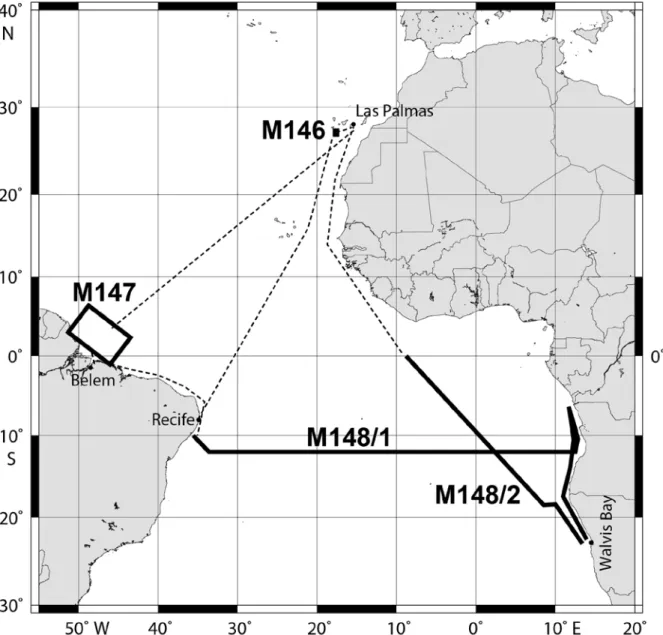
Abb. 1: Geplante Fahrtrouten und Arbeitsgebiete der METEOR Expeditionen M146 - M148/2.
Fig. 1: Planned cruise tracks and working areas of METEOR cruises M146 - M148/2.
6
Wissenschaftliches Programm
Scientific Programme
Fahrt / Cruise M146 – M148/2
Übersicht
Fahrt M146
Hydrothermale Zirkulation von Meerwasser durch die Ozeankruste ist für die Abkühlung der Lithosphärenplatten, für den chemischen Austausch zwischen Kruste und Ozean sowie für marine Ökosysteme von globaler Bedeu- tung. Bei alter Ozeankruste sind für eine sol- che Zirkulation Verbindungswege durch die impermeablen Sedimente erforderlich. Sol- che "Fenster" können durch Seeberge (Se- amounts) bereitgestellt werden, die zu Zehn- tausenden auf dem Meeresboden vorkom- men. Bislang wurden jedoch nur wenige Sea- mounts dokumentiert, an denen Fluidaustritte ohne Bezug zu aktivem Vulkanismus erfol- gen; diese befinden sich auf warmer und re- lativ junger Pazifik-Kruste.
Eine frühere Meteor-Ausfahrt lieferte Proben von Henry Seamount (126 Mio. Jahre alter erloschener Vulkan bei El Hierro, Kanarische Inseln), die erstmals auf hydrothermale Akti- vität in diesem Bereich hindeuten. Um Flu- idaustritte zu lokalisieren, soll der Seamount während M146 detailliert untersucht werden.
Dies beinhaltet (1) hochauflösende Kartie- rung mittels AUV; (2) hochauflösende Re- flexionsseismik zur Bestimmung von Mächtigkeit und Struktur der Sedimentbede- ckung; (3) Messung lokaler Wärmeströme zur Erfassung von Wärmequellen und - senken; (4) Untersuchung potenzieller Fluid- Austrittstellen mit TV-Schlitten; und (5) Be- probungen von Sedimenten. Wir erwarten die erstmalige Dokumentation von Fluidaustrit- ten an einem vulkanisch nicht aktiven Sea- mount auf alter (>60 Ma) Ozeankruste.
Fahrt M147
Die Fahrt findet im Amazonas- Mündungsdelta und der assoziierten Zone des Frischwassereintrags in den Atlantik während der Hochwasser-Saison statt. Der Fokus liegt auf der Biogeochemie von Spu- renmetallen und gelöstem organischen Mate-
Synopsis
Cruise M146
Hydrothermal circulation of seawater through ageing oceanic crust is globally im- portant for cooling of the lithospheric plates, for chemical exchange between crust and ocean, and for marine ecosystems. Efficient circulation through old crust requires base- ment outcrops that form fluid pathways through impermeable sediment. Such
"breathing holes" may be provided by tens of thousands of seamounts covering the global seafloor. A seamount can be a site of fluid discharge or of fluid recharge. However, only few venting seamounts unrelated to ac- tive volcanism have been found so far; these are located on warm and relatively young Pacific crust.
An earlier Meteor cruise yielded dredged samples from Henry Seamount (126 million years old extinct volcano near El Hierro, Canary Islands), which for the first time in- dicated hydrothermal activity in this area.
During cruise M146 we will investigate this seamount in detail with the aim of discover- ing fluid venting sites. This includes (1) high- resolution mapping by AUV; (2) high- resolution seismic reflection profiling to sur- vey thickness and internal structure of sedi- ment layers on and around the seamount; (3) determination of local heat flows to detect heat sinks and sources; (4) TV-sled surveys to explore potential venting sites; and (5) sediment sampling. We expect to obtain the first documentation of fluid venting at a vol- canically inactive seamount located on old (>60 Ma) crust.
Cruise M147
The cruise will take place in the Amazon es- tuary and its associated freshwater plume in the Atlantic during the high discharge sea- son. The focus lies on trace metal and dis- solved organic matter (DOM) biogeo- chemistry and the isotopic characterization 7
rial (DOM), sowie auf der isotopischen Cha- rakterisierung von Wassermassen und Ver- mischungsprozessen.
Hauptziel ist die Untersuchung der Vertei- lung von Spurenmetallen und DOM entlang des Salinitätsgradienten in der Mischungszo- ne des Amazonas-Mündungsgebietes und seiner Süßwasserfahne, um die biogeochemi- schen Prozesse und Interaktionen der Metalle mit DOM und partikulärem Material zu er- fassen. Dies trägt zum Verständnis der Rolle des Amazonas für den Eintrag von Spuren- metallen und DOM in den Atlantik bei. Die Interaktionen von Spurenmetallen und DOM können den Eintrag vermutlich durch Kom- plexbildung verstärken, da sie in Konkurrenz zu kolloidaler Koagulation und Sedimentati- on stehen.
Ein weiterer zu untersuchender Faktor in diesem Zusammenhang ist die Assoziation der Metalle mit physikalisch verschiedenen Größenklassen von Material (echt gelöst, organische und anorganische Kolloide, Parti- kel) entlang des Mischungsgradienten zwi- schen Fluss und Ozean. Deshalb werden ver- schiedene Filtergrößen einschließlich Ultra- filtration verwendet, um die Größenfraktio- nen aufzutrennen.
Die Fahrt ist eine anerkannte Prozessstudie des internationalen GEOTRACES- Programms.
Für die Wasserprobenahme werden eine CTD und eine spurenmetallreine CTD (TM- CTD) benutzt. Letztere ist notwendig, um die sehr geringen Metallkonzentrationen im Ozean messen zu können ohne Kontaminati- on durch die Probenahmetechnik. Zusätzlich wird ein Multicorer (MUC) für die Sediment- und Porenwasserproben zum Einsatz kom- men, um auch das Sediment auf dem Mee- resboden als potentielle Quelle und Senke für Spurenmetalle und DOM zu untersuchen.
Fahrt M148/1
Auf der Forschungsfahrt mit FS Meteor soll im Mai/Juni 2018 ein physikalisches Mess- programm im Küstenauftriebsgebiet vor An- gola und im tropischen Südatlantik entlang von 11°S durchgeführt werden. Die Untersu- chungen sind Teil der BMBF-Verbund- vorhaben Southwest African Coastal Up-
of water masses and mixing processes.
The main goal is to determine in detail the distribution of trace metals and DOM along the salinity gradients in the mixing zone of the Amazon estuary and its associated plume in order to quantify biogeochemical process- es and interaction with DOM and particulate matter. This will enhance our understanding of the riverine contribution to open ocean budgets of trace metals and DOM in the At- lantic. The trace metal flux to the ocean will likely be enhanced by complexation with DOM, which competes with colloidal coagu- lation and sedimentation.
Within this frame, important factor to be considered are trace metal associations with physically different size fractions of matter (truly dissolved, organic and inorganic col- loids, particles) along the salinity gradient between river and ocean. Therefore, a varie- ty of filters including ultrafiltration will be used to separate the different fractions.
The cruise is an accepted GEOTRACES pro- cess study.
For water sampling, a CTD and additionally a trace-metal clean CTD (TM-CTD) will be used, to enable measurements of the very low trace metal concentrations in seawater with- out sampling artefacts. In addition, a multi- corer (MUC) will be deployed for retrieving sediment and pore water samples to also assess the sediment on the seafloor as a source and sink of trace metals and DOM.
Cruise M148/1
During the research cruise on FS Meteor in May/June 2018 it is planned to carry out a physical oceanography study in the tropical South Atlantic at 11°S and in the eastern boundary upwelling region off Angola. The cruise combines the foci of the BMBF col- laborative projects “Southwest African 8
welling System and Benguela Niños II (SA- CUS) und Regionale Atlantikzirkulation im Globalen Wandel (RACE II). Die Hauptziele der Untersuchungen sind: (1) Quantifizierung der Variabilität des Transports und der Was- sermassen der östlichen Randstromzirkulati- on sowie die Ausbreitung von Küstenrand- wellen im Auftriebsgebiet vor Angola; (2) die Durchführung einer 4 tägigen Prozess- studie im Auftriebsgebiet zur Bestimmung der für den Auftrieb verantwortlichen physi- kalischen Mechanismen; und (3) die Auf- nahme eines hydrographischen Schnittes entlang von 11.5°S zur Bestimmung der Stärke der meridionalen Umwälzzirkulation.
Das vorgeschlagene Arbeitsprogramm bein- haltet die Aufnahme und Auslegung von Verankerungen und Bodenschilden, den Ein- satz und die Aufnahme von autonomen Messplattformen (Gleitern), Mikrostruktur- messungen mit einer Turbulenzsonde sowie die Aufnahme von 4 hydrographischen Schnitten im südlichen tropischen Atlantik.
Salzgehalts-, Sauerstoff- und Nährstoffkon- zentrationen sowie deren isotopische Zusam- mensetzung werden anhand von Proben aus der Wassersäule bestimmt.
Kontinuierlich werden während der Fahrt Oberflächentemperatur und –salzgehalt mit dem Thermosalinographen und die Konzent- rationen von N2O, CO, O2 und CO2 im Ober- flächenwasser aufgezeichnet. Ebenfalls kon- tinuierlich werden Strömungsmessungen mit beiden schiffseigenen ADCPs (75 kHz und 38 kHz) durchgeführt.
Zusätzlich zu den wissenschaftlichen Arbei- ten wird während der Forschungsfahrt ein Ausbildungsprogramm für Wissenschaftler und Studierende unserer afrikanischen und anderen internationalen Projektpartnern durchgeführt werden.
Fahrt M148/2
Die Meteor Reise 148/2 „EreBUS“ bezieht sich auf die Untersuchung der mikrobiellen Prozesse zur Produktion und des Verbrauchs der Treibhausgase Methan und Stickoxide im Benguela Auftriebssystem (BUS) und auf die Untersuchung der physikalischen und geo- chemischen Kontrolle zur Regulierung dieser Prozesse.
Coastal Upwelling System and Benguela Niños II (SACUS)” and “Regional Atlantic Circulation and Global Change (RACE II)”.
The major goals of the cruise are (1) to quantify the variability of eastern boundary current transports and the variability of the advection of anomalous water masses along the eastern boundary in conjunction with wave propagation along the coastal wave guides; (2) carry out a 4-day process study to elucidate the mechanism sustaining upwelling off Angola during the austral win- ter season; and (3) to determine the strength of the Atlantic meridional overturning circu- lation at 11.5°S.
The working programme involves the recov- ery and redeployment of moorings and bot- tom shields off Angola, deployments and re- coveries of autonomous observatories (Glid- ers), microstructure measurements, and hy- drographic sampling along 4 transects in the central and eastern tropical South Atlantic.
Salinity, oxygen and nutrient concentrations as well as their isotopic composition will be determined from water samples.
Continuous underway observations will be carried out with the thermosalinograph to measure temperature and salinity as well as trace gas concentrations (N2O, CO, O2 CO2) at the sea surface. Ocean velocity in the upper 1000m will also be continouly measured using the two shipboard ADCPs (OS 38kHz, OS 75kHz).
In addition to the scientific program, a ca- pacity building program for scientists and graduate students from our African and other international project partner institutes will be carried out.
Cruise M148/2
The Meteor Expedition M148/2 “EreBUS”
aims to investigate the microbial processes producing and consuming the trace green- house gases methane and nitrous oxide in the Benguela Upwelling System (BUS) and phys- ical and geochemical controls regulating these processes.
9
Wir werden den Transit von Walvis Bay nach Las Palmas nutzen, um Proben aus der Wassersäule und der Sedimentoberfläche auf dem Namibia-Schelf und über dem Konti- nentalrand bei 18°S im Tiefenwasser zu nehmen. Weiterhin beproben wir die oberen 500m der Wassersäule auf einem Transekt durch den Angola-Wirbel.
Wir werden Mikrobengemeinschaften identi- fizieren, die zum TGG-Umsatz in ausgewähl- ten Wassertiefen und in der Sedimentober- fläche beitragen. Dabei untersuchen wir die metabolischen Eigenschaften dieser Mikro- organismen mit modernsten Kultivierungs- und Genomanalysetechniken. Der Beitrag symbiotischer Mikroorganismen im Zusam- menleben mit kleinen Eukaryoten wird For- schungsbestandteil sein. Hydrographische und –optische Geräte werden zur Unterstüt- zung der Experimente herangezogen werden.
Primärproduktivität und Stickstofffixierung werden gemessen sowie die Spurenmetall- verfügbarkeit und Strömungen bestimmt, die emzymatische Schlüsselprozesse steuern könnten. Quelle und Fortgang ungelöster organischer Verbindungen werden untersucht werden, um ihren Einfluss auf mikrobiellen Abbau zu verstehen.
We will use the transit from Walvis Bay to Las Palmas to sample the water column and surface sediments on the Namibian shelf and across the continental margin at 18°S into deep water, and continue sampling the upper 500 m of the water column on a transect through the Angola Gyre.
We will identify microbial communities con- tributing to TGG turnover at key water and surface sediment depths, and explore the metabolic capacities of these microorgan- isms with state-of-art cultivation and ge- nomic techniques. The contribution of symbi- otic microorganisms living with small eukar- yotes will be investigated. Hydrographic and optical properties will be gathered in support of the experiments. We will measure primary productivity and nitrogen fixation as well as determine the trace metal availability and fluxes that may regulate key enzymatic pro- cesses. The source and fate of dissolved or- ganic matter compounds will be investigated in order to understand their impact on mi- crobial respiration.
10
Von/From Recife – Nach/To Las Palmas Fahrt / Cruise M146
Wissenschaftliches Programm
Hauptziel der Ausfahrt M146 ist die Entdeckung von Orten rezenter Fluidaus- tritte bei Henry Seamount. Dieser erloschene Vulkan ist hierfür hervorragend geeignet:
1) Schalen vesicomyider Muscheln sowie Gesteinsproben, die während M66/1 ge- dredgt wurden, belegen rezente hydrother- male Aktivität. 2) Die Positionen der Dred- gezüge sind gut bekannt, so dass die Stellen der Fluidaustritte lokalisiert werden können.
3) Aufgrund seiner geringen Größe kann Henry Seamount in kurzer Zeit kartiert und detailliert untersucht werden, was das Auf- finden von charakteristischen Fluid-Aus- trittsstellen erleichtert. 4) Die Sediment- bedeckung von Henry Seamount gestattet den Einsatz einer Wärmesonde zur Bestim- mung der lokalen Wärmeströme.
Die wesentlichen Forschungsfragen sind:
• Zeigt Henry Seamount hydrothermale Aktivität? Der Ansatz zum Auffinden von Fluid-Austrittsstellen beruht auf a) hochauflösender Bathymetrie;
b) Reflexionsseismik-Daten, die mög- liche Wegsamkeiten der Fluide im Sediment abbilden; c) Wärmestrom- Profilen mit ggf. lokalen Anomalien;
d) Anomalien im Bodenwasser; und e) Videoaufnahmen der Dredgezüge von M66/1 und anderer Bereiche.
• Beschränken sich Fluid-Austrittsstellen auf Basement-Aufschlüsse und Berei- che dünner Sedimentbedeckung? Dies würde die Bedeutung von Seamounts für Fluidzirkulation in alter sediment- bedeckter Ozeankruste belegen.
• Was sind die mineralogischen und biologischen Konsequenzen der Fluid- austritte? Die bisherigen Proben zeigen hierfür nur ein sehr begrenztes Bild.
Wenn Fluid-Austrittsstellen gefunden werden, dann ist die Beprobung u.a. von Sedimenten geplant, um Hinweise auf die Art der Fluide zu erhalten.
• Zeigen Henry Seamount und seine Um-
Scientific Programme
The main goal of cruise M146 is the discov- ery of recent fluid venting sites at Henry Seamount. This ancient volcano is an out- standing locality to achieve this goal:
1) Shells from vesicomyid clams and rock samples dredged during cruise M66/1 bear evidence of Holocene to Pleistocene hydro- thermal activity. 2) The positions of the suc- cessful dredge hauls from M66/1 are well known, which facilitates the discovery of the venting sites. 3) The small size of Henry Seamount allows for detailed investigation and mapping in a reasonable time, with good chances of finding venting sites. Small seamounts are also favoured sites of fluid discharge. 4) The sediment coverage of Henry Seamount allows for a penetration by heat probe to determine local heat flow.
The main research questions are:
• Does Henry Seamount show hydrother- mal activity? We plan to identify poten- tial discharge sites based on a) high- resolution bathymetry; b) seismic reflec- tion data that may indicate basement outcrops and sediment structures acting as potential fluid pathways; c) heat flow profiles that may indicate local anoma- lies; d) bottom water anomalies; and e) video coverage of the M66/1 dredge tracks and other localities identified.
• Are venting sites restricted to basement outcrops and places with thin sediment cover? Corroboration of this hypothesis would support models of seamounts act- ing as major breathing holes for old sea- floor covered by sediment.
• What are the mineral and biological outcomes of fluid discharge? The sam- ples obtained so far provide a limited picture of mineral deposits and fauna at the venting sites. If venting sites are found then we aim to take sediment and/or rock samples to place constraints on the nature of the vent fluids.
• Is there increased heat flow at Henry 11
gebung einen erhöhten Wärmestrom aufgrund des Kanaren-Hotspots? Die geplanten Wärmestrom-Messungen werden wichtige Daten für Zusammen- stellungen globaler Wärmeströme lie- fern und das Verständnis hydrother- maler Zirkulation durch alternde Ozean- kruste verbessern.
Seamount and its vicinity due to the in- fluence of the Canary hotspot? Our heat flow measurements will be an important contribution to global heat flow compila- tions, and will help to better quantify the driving forces of hydrothermal circula- tion through ageing ocean crust.
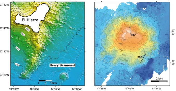
Abb. 2: Links: Bathymetrische Karte der Umgebung von Henry Seamount, der südöstlich von El Hierro aus 3600 m Wassertiefe emporragt. Rechts: Karte von Henry Seamount mit Dredgelokalitäten von Ausfahrt M66/1.
Fig. 2: Left: Bathymetric map from the vicinity of Henry Seamount, rising from 3600 m water depth southeast of El Hierro. Right: Map of Henry Seamount with dredge localities of cruise M66/1.
Arbeitsprogramm
Da die Auflösung der bathymetrischen Daten von Henry Seamount ungenügend ist, werden wir die Bodentopographie mit dem AUV MARUM SEAL-5000 in hoher Auflösung kartieren (Fächerecholot und Seitensicht- Sonar, rund 9 Tauchgänge). Zusätzlich wird ein mitgeführter MAPR (Miniature Auto- nomous Plume Recorder) mögliche Anoma- lien von Temperatur und Redoxpotential in der Wassersäule aufzeichnen.
Zur Bestimmung von Mächtigkeit und inter- ner Struktur der Sedimentbedeckung werden wir ein dichtes Netz von reflexionsseismi- schen Profilen über den Seamount und seiner Umgebung erstellen. Diese Daten sind Vor- aussetzung für die Abschätzung von Tempe-
Work Programme
Because the resolution of current bathymet- ric data for Henry Seamount is insufficient, we will map the entire edifice at high resolu- tion using the AUV MARUM SEAL-5000 equipped with a multi-beam and a sidescan- sonar system. Nine dives will be needed. The AUV will also carry a MAPR (Miniature Au- tonomous Plume Recorder) recording possi- ble anomalies in temperature and redox po- tential in the water column.
Between the dives we will run a dense net of seismic reflection profiles across the sea- mount, as well as some profiles in its vicinity, to survey thickness and internal structure of sediment layers. This data is required for estimating temperatures at the sediment- 12
raturen an der Sediment-Basement-Grenze sowie für die Interpretation von Wärmefluss- Variationen, um Fluidzirkulation zu erken- nen. Die Profile können auch Störungen ab- bilden, welche Fluidtransport ermöglichen.
Neben der Reflexionsseismik wird der Mee- resboden-Untergrund mit dem Parasound- System der METEOR erkundet.
Mit der Bremer Wärmesonde, die in Sedi- mente eingeführt wird, werden wir lokale Wärmestrom-Profile entlang einiger seismi- scher Profile aufnehmen. Die Analyse der Daten kann positive oder negative Anoma- lien des Wärmestroms anzeigen, die Rück- schlüsse auf Fluidzirkulation erlauben.
Die Auswirkungen möglicher Fluidaustritte am Meeresboden werden wir mit einem TV- Schlitten untersuchen, der Bilder online auf das Schiff überträgt. Die Gebiete hierfür werden basierend auf den bisherigen Ergeb- nissen ausgewählt. Lokale Beprobungen des Meeresbodens werden wir mit dem Schwere- lot und/oder Backengreifer durchführen.
basement boundary and for proper interpre- tation of heat flow variations, which may point to sites of fluid recharge or discharge.
The profiles will also allow to image faults along which fluid flow may occur. In addi- tion to reflection seismics the METEOR's sediment subbottom profiler system Para- sound will be used.
Local heat flows will be determined along some of the seismic tracks by penetrating the Bremen Heat Flow Probe into sediment.
Analyses of this data and respective sediment properties may indicate positive or negative anomalies in heat flow, from which fluid cir- culation can be inferred.
The manifestations of potential venting sites will be explored by towing a TV sled with online optical control above the seafloor. The survey tracks will be defined during the cruise based on results obtained so far. If the TV sled surveys show seafloor features in- dicative of venting, then we will take samples using gravity corer and/or grab sampler.
13
Zeitplan / Schedule Fahrt / Cruise M146
Tage/days Auslaufen von Recife (Brasilien) am 17.03.2018
Departure from Recife (Brazil) 17.03.2018
Transit zum Arbeitsgebiet / Transit to working area 9,5
Hochauflösende Kartierung mit AUV 5
High-resolution mapping by AUV
Hochauflösende Reflexionsseismik 6
Multichannel reflection seismics
Wärmestrom-Messungen 4
Heat flow measurements
Beobachtungen mit TV-Schlitten 3
TV-sled surveys
Beprobungen (Schwerelot, Backengreifer, Dredge) 2
Sampling (gravity corer, sediment grab, dredge)
Transit zum Hafen 0,5
Transit to port
Total 30 Einlaufen in Las Palmas (Gran Canaria / Spanien) am 16.04.2018
Arrival in Las Palmas (Gran Canaria / Spain) on 16.04.2018
14
Von/From Las Palmas – Nach/To Belem Fahrt / Cruise M147
Wissenschaftliches Programm
Das Ziel der Forschungsfahrt ist die Untersuchung von Interaktionen zwischen Spurenmetallen und DOM und der Transport von Spurenmetallen, Isotopen und DOM vom Amazonas in den Atlantik.
Geochemische Interaktionen, wie z.B.
Austauschprozesse zwischen gelösten und partikulären Phasen entlang des Salinitäts- gradienten vom Fluss ins offene Meer sollen untersucht werden. Die Elementassozia- tionen in verschiedenen Größenfraktionen im Wasser und mit verschiedenen Kollo- iden, die für den Transport dieser Stoffe eine wichtige Rolle spielen, sollen mithilfe von unterschiedlichen Filtrationsstufen bestimmt werden.
Einige der Forschungsfragen sind:
• Erhöhen die Interaktionen zwischen DOM und Spurenmetallen den Spurenmetalltransport vom Fluss zum Meer und wenn ja, wie groß ist dieser Transport?
• Wie beeinflusst die Konkurrenz von Spurenmetall DOM-Komplexbil- dung und kolloidaler Koagulation und Sedimentation den Transport von Spurenmetallen and DOM?
• Welche Informationen über den Transport der Wassermassen aus dem Amazonas und die Vermi- schungsprozesse bekommen wir durch Isotopen-Studien?
Der Fokus unserer Analysen liegt auf:
• Mikronährstoffen: Fe, Mn, Cu, Ni, Co, Zn, Mo, V
• Partikelreaktiven Elementen: Ti, Zr, Hf, Nb, W, REY
• Potentiellen Indikatoren für anthro- pogene Einflüsse: Hg
• Spurenmetallspeziation: V, Mo, Cr, Cu, Fe
• Molekularer Zusammensetzung und Herkunft von DOM
Scientific Programme
The goal of the cruise is to study interac- tions between trace metals and DOM and the flux of trace metals, isotopes and DOM from the Amazon into the Atlantic. Geo- chemical interactions such as exchange pro- cesses between dissolved and particulate phases will be studied along the salinity gradient of the Amazon freshwater plume into the open ocean. The element associa- tions with different physical size pools in the water is expected to be an important factor for trace metal transport, and hence differ- ent filtration steps will be applied to distin- guish between different size fraction and types of colloids.
Some of the main research questions are:
• Do the interactions between trace metals and DOM enhance trace metal fluxes from the river to the ocean and if so, how big are these fluxes?
• How does competition between trace-metal DOM complex for- mation and colloidal coagulation and sedimentation influence the ex- port of trace metals and DOM?
• Which information about the Ama- zon efflux and the mixing processes can we acquire from isotope stud- ies?
The focus of our analyses lies on:
• Micronutrients: Fe, Mn, Cu, Ni, Co, Zn, Mo, V
• Particle reactive elements: Ti, Zr, Hf, Nb, W, REY
• Potential tracers for anthropogenic metal input: Hg
• Speciation of trace metals: V, Mo, Cr, Cu, Fe
• Molecular composition and origin of DOM
15
• Charakterisierung von Ba-, Nd- und Hf-Isotopen-Flüssen
• Verfolgung von Mischprozessen und der Süßwasserfahne mit radiogenen Isotopen: Nd und Ra
• Characterization of Ba, Nd, and Hf isotopic fluxes
• Tracing mixing processes and the plume using radiogenic isotopes: Nd and Ra
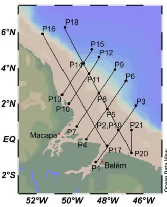
Abb. 3: Geplante Fahrtroute und Arbeitsgebiet der METEOR Expedition M147.
Fig. 3: Planned cruise tracks and working areas of METEOR cruise M147.
Arbeitsprogramm
Die Arbeiten während M147 fokussieren sich auf die Beprobung der Wassersäule mit der CTD und TM-CTD. Die Stationen für beide Geräte sind entlang der Transekte in Abb. 3 geplant. Die TM-CTD Proben wer- den im spurenmetallreinen Container filtriert und in Aliquote für Spurenmetallanalysen in den Heimatlaboren aufgeteilt. Einige Spu- renmetalle werden auch direkt an Bord mit voltammetrischen Methoden bestimmt. An einigen Stationen wird zusätzlich zur Filtra- tion im spurenmetallreinen Container noch Ultrafiltration durchgeführt, um die echt ge- löste Phase analysieren zu können.
Proben für Sauerstoff, Nährstoffe (z.B. Nit- rat, Phosphat, Silikat), Sauerstoff- und Stickstoffisotope und DOM werden von der CTD genommen. Sauerstoff und Nährstoffe
Work Programme
The main focus of work carried out on M147 lies on CTD and TM-CTD sampling of the water column. The stations for both gears are planned along the transects indicated in Figure 3. The TM-CTD samples are filtered and distributed into aliquots for various trace metal analyses in the home labs in the trace metal clean container. Some trace metals will already be analyzed on board using voltammetry. At some stations, ultra- filtration will be applied in addition to the filtration in the trace metal clean container to get samples from the truly dissolved phase.
Samples for oxygen, nutrients (e.g. nitrate, phosphate, silicate), oxygen and nitrogen isotopes and DOM will be taken from the CTD. Oxygen and nutrients are immediately 16
werden auch direkt an Bord analysiert. Auch Inkubations- und Mischexperimente zur Untersuchung des Abbaus von organischem Material werden an Bord stattfinden.
Pumpen zur Analyse von Partikeln und Iso- topen werden parallel zur TM-CTD laufen.
Darüber hinaus sind MUC-Einsätze geplant, um Sediment- und Porenwasserproben zu nehmen. Die MUC-Stationen werden an den Knotenpunkten der Transekte stattfinden.
Porenwasser für Spurenmetall- und Nähr- stoffanalysen wird durch Zentrifugieren und Filtrieren gewonnen.
Während des Transits zwischen Stationen wird ein Fish für großvolumige Wasserpro- ben zum Einsatz kommen.
analyzed on board. Incubation and mixing experiments to assess the degradation of organic matter will be carried out on board as well.
Pumps to take samples for particles and isotope analyses will be run in parallel to the TM-CTD.
Moreover, MUC deployments are planned to sample sediment and pore water. MUC sta- tions will take place at transect junction stations. Pore water is extracted by means of centrifuge and filtration for trace metal and nutrient analyses.
During transit between stations a Fish for large volume water sampling will be em- ployed.
17
Zeitplan / Schedule Fahrt / Cruise M147
Tage/days Auslaufen von Las Palmas (Spanien) am 19.04.2018
Departure from Las Palmas (Spain) 19.04.2018
Transit zum Arbeitsgebiet / Transit to working area 10 TM-CTD/Kranzwasserschöpfer Profile und Probennahme; gleichzeitig Probennahme mit den Pumpen (30 Einsätze) 45 Minuten bis 2 Stunden reine Gerätezeit im Wasser je nach Tiefe; 5-7 Stunden für die anschließende Bearbeitung der TM-CTD Proben 11 TM-CTD/Rosette profile and sampling; at the same time sampling with pumps
(75 deployments) 45 minutes to 2 hours time for the gear in the water; 5-7 hours for
subsequent TM-CTD sample handling
CTD/Kranzwasserschöpfer Profile und Probennahme (30 Einsätze) 45 Minuten bis 2 Stunden reine Gerätezeit im Wasser je nach Tiefe; 3 Stunden für die anschließende
Bearbeitung der Proben 5
CTD/Rosette profile and sampling (30 deployments) 45 minutes to 2 hours time for the gear in the water; 3 hours for subsequent sample handling
MultiCorer Probennahme (21 Einsätze) 45 Minuten bis 2 Stunden reine Gerätezeit im Wasser je nach Tiefe; 5 Stunden für die anschließende Bearbeitung der Proben 5 MultiCorer sampling (21 deployments) ) 45 minutes to 2 hours time for the gear
in the water; 5 hours for subsequent sample handling
Towed Fish Beprobung von Oberflächenwasser (20 Einsätze) 1.5 Towed Fish sampling of surface water (20 deployments)
Transit zum Hafen Belém (Brasilien) 0.5
Transit to port Belém (Brazil)
Total 33 Einlaufen in Belém (Brasilien) am 21.05.2018
Arrival in Belém (Brazil) 21.05.2018
18
Von/From Belem – Nach/To Walvis Bay Fahrt / Cruise M148/1
Wissenschaftliches Programm
Die Zirkulation im Atlantik transportiert als Teil der Atlantischen Meridionalen Um- wälzbewegung (AMOC) große Mengen Wärme und trägt zum großen Teil zum mitt- leren Klimazustand sowie zur Klimavariabi- lität auf dekadischen bis multi-dekadischen Zeitskalen im atlantischen Raum bei. Die Stärker der AMOC wird kontinuierlich ent- lang verschiedener Breiten beobachtet – durch das RAPID-MOCHA Verankerungs- feld bei 26°N, das OSNAP Feld im nördli- chen Subtropenwirbel, Messungen des tiefen westlichen Randstroms bei 16°N und das SAMBA/SAMOC Feld bei 34°S. Für die Klimawissenschaften ist es besonders wich- tig, die meridionale Kohärenz von AMOC Signalen zu verstehen, die aus dem Südat- lantik in den subpolaren Nordatlantik propa- gieren, wobei ein tropisches Beobachtungs- system die Verbindung zwischen der Varia- bilität im Süd- und Nordatlantik darstellen kann.
Innerhalb des BMBF-Verbundprojektes RACE II sollen sowohl die mittlere AMOC, als auch ihre saisonale bis zwischenjährliche Variabilität entlang von 11°S bestimmt wer- den. Dazu wird die AMOC Transportzeitrei- he bei 11°S aus verschiedenen Messungen konstruiert – diese beinhalten Daten eines am westlichen Rand bei 11°S vor Brasilien installierten Verankerungsfeldes, von Bo- dendruckzeitreihen auf dem brasilianischen und angolanischen Schelf (bei 300m und 500m Tiefe) und von wiederholten Schiffs- messungen. Bis heute gibt es allerdings kei- ne Abschätzung der Stärke der AMOC bei 11°S über die Periode, in der das Beobach- tungssystem installiert ist. Die Aufnahme eines tiefen, beckenweiten Schnittes bei 11.5°S wird die Interpretation der Stärken und Schwächen der Transportzeitreihen un- terstützen und eine aktuelle Abschätzung der AMOC im tropischen Südatlantik liefern.
Gleichzeitig erlauben die zu erhebenden hydrographischen Datensätzen die Analyse von Wassermassenänderungen.
Scientific Programme
The circulation system in the Atlantic trans- ports large amounts of heat as part of the Atlantic meridional overturning circulation (AMOC) and is to a large extent responsible for the mean climate state and on decadal to multi-decadal timescale for climate variabil- ity in the atlantic sector. The strength of the AMOC is continuously observed at selected latitudes – by the RAPID-MOCHA array at 26°N, the OSNAP array in the northern sub- polar gyre, measurements of the Deep West- ern Boundary Current at 16°N and the SAMBA/SAMOC array at 34°S. For climate research, it is particularly important to un- derstand the meridional coherence of AM- OC signals propagating from the South At- lantic toward the subpolar North Atlantic with a tropical observing system represent- ing a link between North and South Atlantic MOC variability.
Within the BMBF collaborative project RACE II, the mean, and seasonal to interan- nual variability of the AMOC is determined at 11°S by constructing a transport time series from numerous observations, includ- ing the 11°S mooring array off Brazil, bot- tom pressure sensors on the Brazilian and Angolan shelf (at 300m and 500m depth) and repeated hydrographic observations obtained on research cruises. However, while our observing system was in place, the total strength of the overturning at 11°S has not been determined. The performance of a deep cross-Atlantic transect along 11.5°S will help to better interpret the strength and weaknesses of the transport time series and provide a recent AMOC estimate in the southern tropical Atlantic. Additionally, the hydrographic data collected during this cruise allow investigating changes in water masses in the tropical south Atlantic.
19
In den vergangenen Jahrzehnten erfuhr das Klima des tropischen Atlantiks ausgeprägte Verlagerungen. Am deutlichsten waren die Veränderungen in den östlichen Auftriebs- gebieten ausgeprägt. An den tropischen At- lantik angrenzende afrikanische Länder sind im Hinblick auf gesellschaftliche Entwick- lung, Fischfang und Tourismus auf den Ozean angewiesen und daher stark von den auf dekadischen Zeitskalen stattfinden Kli- maschwankungen betroffen. Darüber hinaus spielen die östlichen Küstenauftriebsgebiete auch eine bedeutende Rolle in der Regulie- rung des globalen Klimas.
Die Ziele des BMBF-Verbundvorhabens SACUS sind, ein verbessertes Verständnis des Klimasystems des tropischen Atlantiks, verbesserte Klimavorhersagen für den tropi- schen Atlantik und eine genauere Quantifi- zierung der Auswirkungen gegenwärtiger und zukünftiger Klimaänderungen sowie die Untersuchung der physikalischen Mecha- nismen der regionalen Klimavariabilität in dem Auftriebsgebiet vor Südwestafrika.
Auf der M148 werden verschiedene Unter- suchungen durchgeführt, die zu den überge- ordneten Zielen des Projektes beitragen:
• Fortführung von Verankerungsmes- sungen des östlichen Randstroms bei 11°S in Kombination mit hydrogra- phischen Messungen, um eine Zeit- reihe zu bestimmen, die relevant für Klimastudien im tropischen und Süd- atlantik ist.
• Analyse kohärenter Signalausbrei- tungen von Wassermassen- und Strö- mungsanomalien auf zwischenjährli- chen bis mehrjährigen Zeitskalen – aus der äquatorialen Region südwärts entlang des küstennahen Wellenka- nals – im Vergleich zur lokal getrie- benen Variabilität am östlichen Rand.
• Analyse der Variabilität des westli- chen Randstroms und Benguela Ni- nos im Vergleich zu Klimamoden und Variabilität der Zirkulation im tropischen Atlantik.
• Einsicht in die physikalischen Pro- zesse, die mit dem Auftriebsphäno-
The tropical Atlantic climate experienced pronounced shifts. The related oceanic changes were largest in the eastern bounda- ry upwelling systems. African countries bor- dering the Atlantic strongly depend upon their ocean - societal development, fisheries, and tourism. They were strongly affected by these decadal climatic changes and will face important adaptation challenges associated with global warming. The eastern boundary upwelling regions are also of great climatic importance, playing a key role in regulating global climate.
The main focus of the BMBF collaborative Project SACUS is to enhance our knowledge of the functioning of the tropical Atlantic climate system, improve climate prediction and advance understanding of the physical mechanisms of regional climate variability in the southwest African upwelling region.
During M148 various investigations will be carried out which contribute to the overall goals of the project:
• Continuing moored boundary cur- rent measurements at the eastern boundary at 11°S together with re- peat hydrographic measurements to establish a time series relevant for climate studies of the tropical and South Atlantic region;
• analyzing the coherent signal propa- gation of water mass and current anomalies on intraseasonal to inter- annual time scales from the equato- rial region southward along the coastal waveguide in comparison to locally forced eastern boundary var- iability;
• analyzing eastern boundary current variability and Benguela Ninos in comparison to tropical Atlantic cli- mate modes and circulation variabil- ity;
• advancing the understanding of the physical processes associated with 20
men am Kontinentalhang und Schelf assoziiert sind; sowie die Aufklärung von Mechanismen, die den Auftrieb während der Wintermonate in der Südhemisphäre aufrechthalten.
Zusätzlich zu den wissenschaftlichen Arbei- ten wird auf der M148 Reise ein Ausbil- dungsprogramm für internationale Wissen- schaftler und Studenten im Rahmen des SACUS Projektes und des EU AtlantOS Projektes durchgeführt.
the upwelling phenomena on the continental slope and shelf, as well as elucidate the mechanisms sustain- ing upwelling during austral winter season.
In addition to the scientific program, a ca- pacity building program for scientists and graduate students from African and other international institutes supported by the BMBF-SACUS the EU AtlantOS projects will be carried out.
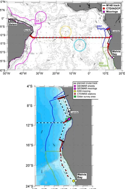
Abb. 4: Das Arbeitsgebiet der Reise M148/1. Auf dem transatlantischen Schnitt entlang von 11.5°S (oben) werden Stationsarbeiten mit hoher horizontaler Auflösung durchgeführt. Das zweite Arbeitsgebiet ist die Benguela Auftriebsregion vor Angola und Namibia (unten).
Fig. 4: The working area of cruise M148/1. On the transatlantic section station work will be per- formed with high horizontal resolution. The second working area is the Benguela upwelling region off Angola and Namibia (lower panel).
21
Arbeitsprogramm
Das vorgeschlagene Arbeitsprogramm kann in 5 Segmente unterteilt werden. In chrono- logischer Abfolge sind das:
• ein sich auf die AMOC beziehender tiefer transatlantischer Schnitt mit hoher horizontaler Auflösung entlang von 11.5°S.
• Stations- und Verankerungsarbeiten am östlichen Rand bei 11°S, wobei 2 Verankerungen, 1 Bodenschild und zwei Bodendrucksensoren (PIES) ge- borgen und erneut ausgesetzt werden sollen.
• Eine 4-tägige Prozessstudie vor der angolanischen Küste bei 11°S, bei der autonome, verankerte und schiffsge- tragene Messungen benutzt werden, um unser Verständnis für die physika- lischen Prozesse im Zusammenhang mit dem Auftriebsphänomen am Kon- tinentalhang und Schelf zu verbes- sern.
• Stationsarbeit entlang von 6°S etwas südlich des Kongo-Ausstromes.
• Stationsarbeit bei 15°S vor der Wüste Namib (Angola), sowie quer durch die Angola-Benguela-Front entlang der 500m Tiefenlinie von 15°S süd- wärts bis 23°S.
Stationsarbeiten entlang aller Schnitte bein- halten Messung von Leitfähigkeit-Tem- peratur-Tiefe und Sauerstoff (CTD/O2) Profi- len zusammen mit Geschwindigkeitsprofilen durch an der Rosette gefierte akustische Doppler Stromprofilmesser (ADCP) sowie Geschwindigkeitsscherung und Temperatur- profile von einer schiffsgebundenen Mikro- struktursonde. Entlang der Schnitte gesam- melte Wasserproben werden hinsichtlich Salzgehalt, Sauerstoff, Nährstoffe, deren Iso- tope und Spurengase, wie Lachgas (N2O) und Kohlenstoffmonooxid (CO) analysiert.
Für Messungen der Variabilität der hydro- graphischen Eigenschaften, der Nährstoffe und der Turbulenz in der Auftriebsregion vor Angola werden 2 SLOCUM Gleiter einge- setzt. Diese autonomen Observatorien mes-
Work Programme
The proposed working program can be sub- divided into 5 segments. In chronological order these are:
• an AMOC related full-depth transat- lantic section with high horizontal resolution along 11.5°S;
• section and mooring work at the east- ern boundary at 11°S where 2 moor- ings, a bottom shield and two PIES will be recovered and redeployed;
• a 4-day process studies off the Ango- lan coast at about 11°S using auton- omous, moored and ship-board measurements to advance under- standing of the physical processes as- sociated with the upwelling phenom- ena on the continental slope and shelf;
• section work along 6°S just south of the Congo River inflow;
• section work at 15°S of Namib (Ango- la) and a section across the Angola- Benguela front along the 500m iso- baths from 15°S to the 23°S.
Station work along all sections includes measurements of conductivity-temperature- depth and oxygen (CTD/O2) profiling paired with lowered acoustic Doppler current pro- filing (ADCP), and shipboard profiling of microstructure velocity shear and tempera- ture. Water samples collected on the sections will be analysed for concentration of salinity, oxygen, nutrients, their isotopic composition, and trace gases such as nitrous oxide (N2O) and carbon monoxide (CO).
To survey hydrographic variability and tur- bulence in key regions of the Benguela upwelling system, 2 SLOCUM gliders will be deployed. The gliders are capable of auton- omously measuring temperature, salinity, 22
sen Temperatur, Salzgehalt, Tiefe, Sauerstoff und Chlorophyll-Konzentrationen sowie die Trübung im Wasser. Zusätzlich wird einer der Gleiter mit einer Mikrostruktursonde bestückt, die die Stärke der Turbulenz im Ozean beprobt. Der zweite Gleiter wird mit einem zusätzlichen Nitratsensor eingesetzt.
Am Anfang der 4 tägigen Auftriebsstudie werden zwei Lander mit nach oben messen- den ADCPs und eine Verankerung mit 2 ADCPs auf dem Schelf vor Angola ausge- legt. Diese werden nach Abschluss des 6°S wieder geborgen.
Mit einem Thermosalinographen werden kontinuierlich Unterwegsmessungen durch- geführt, um Temperatur und Salzgehalt an der Meeresoberfläche aufzunehmen. Schnitte von einer während voller Fahrt einsetzbaren CTD (bis 600m Tiefe) und Geschwindigkei- ten (in den oberen 1000m, wofür die zwei Schiffs-ADCPs - OS 38kHz und OS 75kHz - benutzt werden) werden die gesamte Fahrt über gemessen. Kontinuierlich werden auch die Konzentrationen von Spurengasen (N2O, CO2 und CO) in der Deckschicht mit einem Spektrometer bestimmt, welches an ein Äquilibriesystem gekoppelt ist. Gleichzeitig werden die Sauerstoffkonzentrationen in der Deckschicht mit einer an das System ange- brachten Optode bestimmt.
depth, oxygen, chlorophyll and turbidity.
Additionally, a microstructure probe (Mi- croRider) measuring the strength of will be attached to one of the two gliders. The sec- ond glider will carry an additional nitrate sensor. Additionally, short term deployments of 2 landers equipped with upward-looking ADCPs and a mooring equipped with an up- ward and a downward-looking ADCP will be deployed at the beginning of the 4-day upwelling process study and recovered after completion of the 6°S transect.
Continuous underway observations will be carried out with the thermosalinograph to measure temperature and salinity at the sea surface. Underway CTD (down to 600m) and velocity (in the upper 1000m using the two shipboard ADCPs - OS 38kHz and OS 75kHz) sections will be collected during all transits between sections and along the transatlantic section at 11.5°S. Finally, an off-axis integrated cavity output spectroscopy analyzer coupled to water equilibration sys- tem will be used for underway high- resolution measurements of trace gas con- centrations (N2O, CO2, and CO) and an optode for underway oxygen concentration at near the surface.
23
Zeitplan / Schedule Fahrt / Cruise M148-1
Tage/days Auslaufen von Belem (Brasilien) am 24.05.2018
Departure from Belem (Brasil) 24.05.2018
Transit zum Arbeitsgebiet / Transit to working area 5.5
CTD Stationsarbeiten / CTD station work 8
Mikrostrukturstationen / Microstructure stations 1 Aufnahme und Auslegung von 5 Verankerungen / Landern 1 Recovery and redeployment of 5 moorings / lander
Aufnahme und Auslegung von 1 Bodenschild und 2 PIES 0.5 Recovery and redeployment of 1 bottom shield and 2 PIES
Auslegung von 8 ARGO Floats / Deployment of 8 ARGO floats 0.5
Auslegung von 2 Gleitern/ 2 Glider deployments 0.5
Transit zwischen den Stationen / Transit between stations 17.5
Transit nach Walvis Bay / Transit to Walvis Bay 0.5
Total 35 Einlaufen in Walvis Bay (Namibia) am 29.06.2018
Arrival in Walvis Bay (Namibia) 29.06.2018
24
Von/From Walvis Bay – Nach/To Las Palmas,
Fahrt / Cruise M148/2
Wissenschaftliches Programm
Die Ozeane dienen als Quellen der klimarelevanten Treibhausgase (TGG) Methan (CH4) und Stickoxid (N2O).
Hochproduktive Küstenauftriebsgebiete sind gut dokumentierte Orte erhöhten atmosphärischen Flusses von N2O und mög- licherweise von Methan. Die Forschung während der Meteor-Ausfahrt M148/2 ist ausgerichtet auf die Verteilung und das Aus- maß der am TGG-Zyklus beteiligten Pro- zesse in der Wassersäule und in den Ober- flächensedimenten des Benguela-Auftriebs- systems (BUS). Der Auftrieb an der Küste des BUS wird gespeist durch nährstoff- reiches und sauerstoffarmes South Atlantic Central Water from the Angola gyre. Das BUS weist ausgeprägte Sauerstoffführung und enge benthische und ozeanische Verbin- dungen auf, die Entstehung und Verbrauch von TGG begünstigen.
Die wissenschaftliche Arbeit ist auf zwei Hauptforschungsziele ausgerichtet:
I. Bestimmung der Entstehung und des Ver- brauchs der Treibhausgase N2O und CH4 in Oberflächensedimenten und der Wasser- säule des Benguela Auftriebs. Ein Haupt- aspekt wird die Quantifizierung der Prozesse und die Identifizierung mikrobieller Gemeinschaften sein, die zum TGG-Umsatz in zentralen Wasser- und Oberflächen- sedimenttiefen beitragen. Zusätzlich wird die Verteilung mit kleinen Eukaryoten zusammenlebender symbiotischer Mikro- organismen untersucht. Wir werden die metabolischen Kapazitäten dieser Mikro- organismen mit moderner Technik in Kulti- vierung, Metagenomik und Metatrans- kriptomik erforschen.
II. Beleuchten der Faktoren, die Reaktionen bewirken und kontrollieren, die zu Pro- duktion und Verbrauch von TGG im Benguela Auftriebssystem führen. Beson- ders die physikalische Ozeanographie und Lichtverteilung werden wir untersuchen sowie die Spurenmetallverfügbarkeit und Ströme bestimmen, die enzymatische Schlüsselprozesse regulieren könnten. Ein
Scientific Programme
The global oceans act as net sources of cli- mate-relevant trace greenhouse gases (TGG) methane (CH4) and nitrous oxide (N2O). Highly productive coastal upwelling areas are sites of enhanced atmospheric fluxes of N2O and of methane. Research on Meteor cruise M148/2 focuses on the distri- bution and magnitude of processes contrib- uting to the cycling of TGG throughout the water column and surface sediment of the Benguela Upwelling System (BUS). Coastal upwelling in the BUS is fed by the the nutri- ent rich and oxygen depleted South Atlantic Central Water from the Angola gyre. The BUS exhibits distinct oxygen regimes and tight benthic pelagic coupling that allows for both formation and consumption of TGG.
The scientific work is organized around two major research goals:
I. Determine the formation and consumption of the trace greenhouse gases N2O and CH4 in surface sediments and the water column of the Benguela Upwelling. A major aspect will be to quantify processes and identify microbial communities contributing to TGG turnover at key water and surface sediment depths. Additionally, the contribution of symbiotic microorganisms living with small eukaryotes will be investigated. We will ex- plore the metabolic capacities of these mi- croorganisms with state-of-art cultivation, metagenomics, metatranscriptomic tech- niques
II. Examine the factors that control and af- fect the reactions leading to production or consumption of TGG in the Benguela Upwelling System. Specifically, we will ex- amine the physical oceanography and light distributions, as well as determine the trace metal availability and fluxes that may regu- late key enzymatic processes. A goal will be to investigate the source and fate of dis- 25
Ziel wird die Untersuchung der Quelle und Vorkommen der Bestandteile gelösten orga- nischen Materials (DOM) sein. Insbesondere Schwefel enthaltende Bestandteile, um deren Einfluss auf mikrobiellen Abbau und globale DOM-Stabilität zu verstehen. Wir werden Hyperspektralradiometer installie- ren, um die Farbe des Wassers entlang der Strecke zu untersuchen, um dies mit Was- serbestandteilen wie DOM, Chl und davon abhängigem, partikelförmigem Material in Verbindung zu bringen. Wir werden Gesamt- und Einzelzellraten der Primär- produktion und N2-Fixierung in Küsten- regionen und dem Angola-Wirbel bestim- men, die das Benguela-Auftriebssystem speisen sowie die Verteilung und Diversität N2-fixierender Mikroorganismen mit Mar- kergenen für N2-Fixierung (nifH) unter- suchen.
solved organic matter (DOM) compounds, in particular sulfur containing compounds, in order to under-stand their impact on mi- crobial respiration and global DOM stabil- ity. We will install hyperspectral radiome- ters to examine the water color along the track and link this to in water constituents such as DOM, Chl and suspended particu- late material. We will determine bulk and single cell rates of primary productivity and N2 fixation in the near-shore regions and the Angola Gyre that feeds into the Beguela Upwelling system, as well as explore the distributionand diversity of N2 fixing micro- organisms via the marker gene for N2 fixa- tion (nifH).
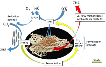
Abb. 5: Verbindung von Treibhausgas (TGG)-Produktion unter anaeroben Bedingungen durch Scuticociliates, (Eukaryoten), in denen die Methanogenik enthalten ist.
Fig. 5: Coupling of trace greenhouse gas (TGG) production under anaerobic conditons by scuticociliates (Eukaryotes) that host methanogenic archaea.
26
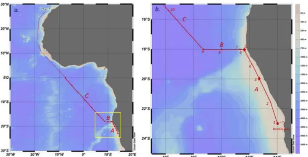
Abb. 6: Das Arbeitsgebiet der Ausfahrt M148/2 einschließlich EreBUS-Transekt A, B und C. Rote Punk- te sind Stationen und gestrichelte Linien kennzeichnen den Transit nach Las Palmas. Der gelbe Kasten zeigt das in (b) abgebildete Gebiet, in dem Sterne die Stationen für großflächige Proben- nahmen markieren. Verankerungen werden an den Stationen 1 und 5 auf Transekt A durchge- führt.
Fig. 6: The working area of cruise M148/2 including Erebus transects A, B, and C. Red dots indicate stations and dashed line shows final transit to Las Palmas. Yellow box indicates area depicted in (b.), where stars indicate stations with extensive sampling. Moorings will be serviced at stations 1 and 5 on Transect A.
Arbeitsprogramm
Transekt- und Stationsplan: Von Stationen entlang dreier Transekte werden Proben ge- nommen werden für Messungen an Bord, zur Aufbereitung für weitere Messungen in den Institutslaboratorien und Experimente an Bord während des Transits. Hydrographische Standardparameter werden gesammelt per CTD, schiffsmontierten ADCP und Schiffsthermosalinometern.
A. Namibisches Schelf: An den Hauptstatio- nen beginnt die Arbeit mit der Kontrolle und Wiederverankerung der ersten von zwei oze- anographischen Verankerungen des IOW (positioniert bei 23°S und 18°S). Danach erfolgt die Stationsarbeit mit Profilerstellung der Wassersäule per CTD. Ausgedehnte Pro- bennahme für Experimente an Bord unter Einsatz von stabilen Isotopen- und Radioiso- topen-Markern wird an drei Plätzen des Na- mibischen Schelfs stattfinden. Wir werden die CTD-Pumpe anwenden, um anoxische Proben zu erhalten und Go-Flo-Flaschen für Spurenelemente einsetzen. Oberflächensedi-
Work Programme
Transect and Station Plan: Samples will be taken from stations along three transects for onboard measurements, processing for fur- ther measurements in home laboratories, and on-board experimentation during the transit.
Standard hydrographic parameters will be gathered with the CTD, the vessel mounted ADCP and ship thermosalinometer.
A. Namibian Shelf: At the main stations, sta- tion work will commence with the servicing and redeployment of the first of two IOW oceanographic moorings (located at 23°S and 18°S). Afterwards, station work will start with CTD profiling of the water column. . Extensive sampling for onboard experimen- tation using stable and radioisotope tracers will take place at three of the sites on the Namibian shelf. We will deploy a Pump-CTD to obtain anoxic samples, and Go-Flo bottles for trace elements. Surface sediment samples will be taken using a Multi-corer. Data gath- ered with the oceanographic moorings con- 27
mentproben werden per Multi-Corer ge- nommen werden. Die mit ozeanographischen Ankern gesammelten Daten führen Langzeit- studien zu Umweltbedingungen im nördli- chen Benguela-Auftriebssystem fort.
B. Kontinentrandübergreifender Transekt:
Bei 17°30’ S werden wir nach Westen dre- hen und quer über Schelf, Hang und Anstieg in den offenen Südatlantik Proben nehmen.
Auf diesem Transekt wollen wir Proben be- kommen, die Kontinentalrand und Stationen vor der Küste miteinander verbinden, beson- ders um Metallverteilung und Stickstofffixie- rungsraten zu untersuchen. Zusätzlich zur Wassersäulenbeprobung werden wir Proben vom Oberflächensediment nehmen.
C. Offener Ozean Transekt: Auf dem Tran- sekt vom Namibischen Kontinentalschelf zum Äquator werden wir Proben nehmen und in der euphotischen Zone des subtropischen Südatlantiks (Angola-Wirbel) täglich biogeo- chemische Ratenmessungen durchführen.
Dies wird uns erlauben, die Sauerstoffmini- mumzone unterhalb des Angola Domes in einer Zeit zu beproben, in der die Intertropi- sche Konvergenzzone (ITCZ) höchstwahr- scheinlich auf ihrer nördlichsten Position ist.
Wassersäulenproben zur Bestimmung von Primärproduktionsraten und N2-Fixierung sowie die Verteilung von Foraminifera, Chlorophyll a und Pikoplankton wird von Niskin-Proben genommen und von Plank- tonnetzproben über den oberen 500m der Wassersäule.
tinue long time series of environmental con- ditions in the Northern Benguela Upwelling systems.
B. Cross-Continental Margin transect: At 17°30’ S we will turn west and sample across the shelf, slope and rise into the open South Atlantic Ocean. The goal of this transect is to obtain samples linking the continental mar- gin and offshore stations, especially for the purposes of examining metal distributions and nitrogen fixation rates. In addition to water column sampling, we will sample sur- face sediment.
C. Open ocean transect: On the transect from the Namibian continental margin to the equator we will obtain samples and perform biogeochemical rate measurements in the euphotic zone of the sub-tropical South At- lantic (Angola Gyre) on a daily basis. This will allow us to sample the oxygen minimum zone underlying the Angola Dome at a time when the Intertropical Convergence Zone (ITCZ) is most likely at its northernmost po- sition. Water column samples for the deter- mination of rates of primary production and N2 fixation, as well as distributions of foram- inifera, chlorophyll a, and picoplankton will be obtained from Niskin samples and from the plankton net samples over the upper 500 meters of the water column.
28
Zeitplan / Schedule Fahrt / Cruise M148/2
Tage/days Auslaufen von Walvis Bay (Namibia) am 02.07.2018
Departure Walvis Bay (Namibia) from 02.07.2018
Transit zum Arbeitsgebiet / Transit to working area 0,5
Transekt A (Schelf vor Namibia) 3,5
Transect A (Namibian shelf)
Transekt B (Kontinental Hang) 1,5
Transect B (/Continental Slope)
Transekt C (offenes Meer; subtropischer Südatlantik) 5,5 Transect C (open ocean; Subtropical South Atlantic)
Transit zum Hafen Las Palmas, Gran Canaria (Spanien) 7,5 Transit to port Las Palmas,Gran Canaria, (Spain)
Total 18,5 Einlaufen in Las Palmas, Gran Canaria (Spanien) am 20.07.2018
Arrival in Las Palmas, Gran Canaria, (Spain) on 20.07.2018
29