Version 4.20
Documentation
20182019
3D City
Database
The images on the cover page were provided by:
- Chair of Photogrammetry and Remote Sensing & Chair of Cartography, Technische Universität München
- Geobasisdaten: © Stadtvermessung Frankfurt am Main - IDAC Ltd, UK.
- virtualcitySYSTEMS GmbH, Berlin, Germany
- Chair of Geoinformatics, Technische Universität München. Image created based on master thesis work of Matthias Körner, jointly supervised with HTW Dresden - 3D City Model of Berlin © Berlin partner GmbH
- M.O.S.S. Computer Grafik Systeme GmbH, Taufkirchen, Germany
Versions of software packages
This documentation covers the following versions of the 3D City Database and its tools.
Software package Version
3D City Database 4.0.1, 4.0.0
Importer/Exporter and plugins 4.2.x, 4.1.x, 4.0.00
3DCityDB-Web-Map-Client 1.6.21
Web Feature Service 4.2.x, 4.1.0x, 4.0.0
Active participants in development
Name Institution Email
Thomas H. Kolbe Son H. Nguyen Kanishk Chaturvedi Bruno Willenborg Andreas Donaubauer
Chair of Geoinformatics, Technische Universität München
thomas.kolbe@tum.de son.nguyen@tum.de kanishk.chaturvedi@tum.de b.willenborg@tum.de andreas.donaubauer@tum.de Claus Nagel
Zhihang Yao
virtualcitySYSTEMS GmbH, Berlin cnagel@virtualcitysystems.de zyao@virtualcitysystems.de Harald Schulz
Philipp Willkomm György Hudra
M.O.S.S. Computer Grafik Systeme GmbH, Taufkirchen, Germany
hschulz@moss.de pwillkomm@moss.de ghudra@moss.de Felix Kunde Beuth University of Applied Sciences felix-kunde@gmx.de
Participants in earlier developments
The 3D City Database Version 4.0.0 and its tools are based on earlier versions. During the development phase 2006-2012 at the Institute for Geodesy and Geoinformation Science, TU Berlin, the following individuals contributed to the development:
Name Institution Email
Thomas H. Kolbe Claus Nagel Javier Herreruela Gerhard König Alexandra Lorenz (geb. Stadler) Babak Naderi
Institute for Geodesy and Geoinformation Science, Technische Universität Berlin
Felix Kunde University of Potsdam
During the development phase 2004-2006 at the Institute for Cartography and Geo- information, University of Bonn, the following individuals contributed to the development:
Name Institution Email
Thomas H. Kolbe Lutz Plümer Gerhard Gröger Viktor Stroh Jörg Schmittwilken
Institute for Cartography and Geoinformation, University of Bonn
Andreas Poth Ugo Taddei
lat/lon GmbH, Bonn
Table of Contents
DISCLAIMER ...11
1 INTRODUCTION ...13
1.1 Main features of 3DCityDB ...15
1.2 System and design decisions ...20
1.3 List of changes between software versions ...21
1.3.1 Notable changes between 4.0 and 3.3 ...21
1.4 Development history ...23
1.5 Acknowledgements ...24
2 DATA MODELLING AND DATABASE DESIGN ...27
2.1 Simplification compared to CityGML 2.0.0 ...27
2.1.1 Multiplicities, cardinalities and recursions ...27
2.1.2 Data type adaptation ...28
2.1.3 Project specific classes and class attributes ...28
2.1.4 Simplified design of GML geometry classes ...28
2.2 UML class diagram ...28
2.2.1 Geometric-topological Model ...29
2.2.2 Implicit Geometry ...30
2.2.3 Appearance Model ...31
2.2.4 Thematic model ...34
2.2.4.1 Core Model ...34
2.2.4.2 Building model ...36
2.2.4.3 Bridge Model ...39
2.2.4.4 CityFurniture Model ...42
2.2.4.5 Digital Terrain Model ...43
2.2.4.6 Generic Objects and Attributes ...45
2.2.4.7 LandUse Model ...47
2.2.4.8 Transportation Model ...47
2.2.4.9 Tunnel Model ...49
2.2.4.10Vegetation Model ...52
2.2.4.11WaterBodies Model ...53
2.3 Relational database schema ...55
2.3.1 Mapping rules, schema conventions ...55
2.3.1.1 Mapping of classes onto tables ...55
2.3.1.2 Explicit declaration of class affiliation ...55
2.3.2 Conceptual database structure ...58
2.3.3 Database schema ...59
2.3.3.1 Metadata Model ...59
2.3.3.2 Core Model ...62
2.3.3.3 Tables for geometry representation ...64
2.3.3.4 Appearance Model ...71
2.3.3.5 Building Model ...76
2.3.3.6 Bridge Model ...82
2.3.3.7 CityFurniture Model ...84
2.3.3.8 Digital Terrain Model ...85
2.3.3.9 Generic Objects and Attributes ...87
2.3.3.10LandUse Model ...89
2.3.3.11Transportation Model ...89
2.3.3.12Tunnel Model ...91
2.3.3.13Vegetation Model ...93
2.3.3.14WaterBody Model ...94
2.3.4 Sequences ...95
2.3.5 Definition of the CRS for a 3D City Database instance ...96
3 IMPLEMENTATION AND INSTALLATION ...99
3.1 System requirements ...99
3.1.1 3D City Database ...99
3.1.2 Importer/Exporter Tool ...99
3.2 Installation of the Importer/Exporter and the 3D City Database SQL Scripts ...100
3.3 Setting up the database schema ...102
3.3.1 Shell Scripts ...102
3.3.2 SQL Scripts ...103
3.3.3 Installation steps on Oracle Databases ...103
3.3.4 Installation steps on PostgreSQL ...106
3.4 Working with multiple database schemas ...108
3.4.1 Create and address database schemas ...108
3.4.2 Read and write access to a schema ...109
3.4.3 Schema support in stored procedures ...109
3.5 Migration from previous major releases ...110
3.5.1 V2 to V4 Migration on Oracle ...111
3.5.2 V2 to V4 Migration on PostgreSQL ...113
3.5.3 V3 to V4 Migration ...113
3.6 Upgrade between minor releases ...113
4 STORED PROCEDURES AND ADDITIONAL FEATURES ...115
4.1 User-defined data types ...115
4.2 CITYDB_UTIL ...116
4.3 CITYDB_CONSTRAINT ...117
4.4 CITYDB_IDX ...118
4.5 CITYDB_SRS ...119
4.6 CITYDB_STAT ...120
4.7 CITYDB_OBJCLASS ...120
4.8 CITYDB_DELETE ...120
4.9 CITYDB_ENVELOPE ...123
5 IMPORTER / EXPORTER ...125
5.1 Running and using the Importer / Exporter ...125
5.2 Database connections and operations ...128
5.2.1 Managing and establishing database connections ...128
5.2.2 Executing database operations ...130
5.3 Importing CityGML files ...137
5.4 Exporting to CityGML ...142
5.4.1 SQL queries ...147
5.4.2 XML query expressions ...149
5.4.2.1 <typeNames> parameter ...149
5.4.2.2 <propertyNames> projection clause ...151
5.4.2.3 <filter> selection clause ...152
5.4.2.4 <count> parameter ...160
5.4.2.5 <lods> parameter ...161
5.4.2.6 <appearance> parameter ...162
5.4.2.7 <tiling> parameter ...163
5.4.2.8 targetSrid attribute ...164
5.4.2.9 Using address information and 3DCityDB metadata in queries 164 5.4.2.10Using XML queries in batch processes ...166
5.5 Exporting to KML/COLLADA/glTF ...167
5.5.1 Support of GenericCityObject having any geometry types ...174
5.5.2 Loading exported models in Google Earth and Cesium Virtual Globe ...175
5.6 Preferences ...178
5.6.1 CityGML import preferences ...179
5.6.1.1 Continuation ...179
5.6.1.2 gml:id handling ...180
5.6.1.3 Address ...181
5.6.1.4 Appearance ...183
5.6.1.5 Geometry ...183
5.6.1.6 Indexes ...185
5.6.1.7 XML validation ...186
5.6.1.8 XSL Transformation ...187
5.6.1.9 Import log ...188
5.6.1.10Resources ...189
5.6.2 CityGML export preferences ...192
5.6.2.1 CityGML version ...192
5.6.2.2 Tiling options ...192
5.6.2.3 CityObjectGroup ...193
5.6.2.4 Address ...194
5.6.2.5 Appearance ...195
5.6.2.6 XLinks ...196
5.6.2.7 XSL Transformation ...197
5.6.2.8 Resources ...198
5.6.3 KML/COLLADA/glTF export preferences ...199
5.6.3.1 General Preferences ...199
5.6.3.2 Rendering Preferences ...204
5.6.3.3 Information Balloon Preferences ...213
5.6.3.4 Altitude/Terrain Preferences ...220
5.6.3.5 General setting recommendations ...225
5.6.4 Management of user-defined coordinate reference systems ...227
5.6.5 General preferences ...229
5.6.5.1 Cache ...229
5.6.5.2 Import and export path ...230
5.6.5.3 Network proxies ...230
5.6.5.4 API Keys ...231
5.6.5.5 Logging ...232
5.6.5.6 Language selection ...234
5.7 Map window for bounding box selections ...235
5.8 Using the command line interface (CLI) ...238
6 IMPORTER / EXPORTER PLUGINS ...241
6.1 Introduction to the plugin architecture ...241
6.2 Spreadsheet Generator Plugin (SPSHG) ...242
6.2.1 Definition ...242
6.2.2 Plugin installation ...242
6.2.3 User Interface ...243
6.2.3.1 Main Parameters ...243
6.2.3.2 Columns ...244
6.2.3.3 Content Source ...249
6.2.3.4 Output ...249
6.3 ADE Manager Plugin ...256
6.3.1 Definition ...256
6.3.2 Plugin installation ...256
6.3.3 User Interface ...258
6.3.3.1 ADE Registration ...258
6.3.3.2 ADE Transformation ...261
6.3.4 Workflow of extending the Import/Export Tool ...264
7 WEB FEATURE SERVICE ...271
7.1 System requirements ...271
7.2 Installation ...272
7.3 Configuring the Web Feature Service ...274
7.3.1 Database settings ...274
7.3.2 Capabilities settings ...277
7.3.3 Feature type settings ...278
7.3.4 Operations settings ...279
7.3.5 Postprocessing settings ...280
7.3.6 Server settings ...281
7.3.7 Cache settings ...282
7.3.8 Constraints settings ...282
7.3.9 Logging settings ...283
7.4 Using the Web Feature Service ...284
7.4.1 Basic functionality ...284
7.4.1.1 WFS operations ...284
7.4.1.2 Service URL ...285
7.4.1.3 Service bindings ...286
7.4.1.4 CityGML feature types ...286
7.4.1.5 Exception reports ...287
7.4.2 GetCapabilities operation ...287
7.4.3 DescribeFeatureType operation ...288
7.4.4 ListStoredQueries operation ...290
7.4.5 DescribeStoredQuery operation ...291
7.4.6 GetFeature operation ...293
7.5 Web-based WFS client ...295
8 3DCITYDB-WEB-MAP-CLIENT ...297
8.1 System requirements ...298
8.2 Installation and configuration ...298
8.3 Using the 3D web client ...300
8.3.1 Overview of the relevant features and functionalities ...300
8.3.2 Handling KML/glTF models with online spreadsheet ...305
8.3.3 Handling Web Map Service data ...312
8.3.4 Handling Digital Terrain Models ...314
8.3.5 Interaction with 3D objects ...316
8.3.6 Mobile Support Extension ...322
8.3.7 Using the 3D Web Client from the 3DCityDB homepage ...324
9 3DCITYDB DOCKER IMAGES ...325
9.1 Getting started ...325
9.2 Further images ...326
10 REFERENCES ...327
APPENDIX A CHANGELOG ...331
A.1 3D City Database relational schema ...331
A.1.1 General changes ...331
A.2 3D City Database scripts ...331
A.3 3D City Database stored procedures ...332
A.3.1 General changes ...332
A.3.2 UTIL package ...332
A.3.3 IDX package ...332
A.3.4 SRS package ...332
A.3.5 STAT package ...332
A.3.6 DELETE package ...332
A.3.7 DELETE_BY_LINEAGE package ...333
A.3.8 ENVELOPE package ...333
A.4 3D City Database Importer/Exporter ...333
A.4.1 General changes ...333
A.4.2 CityGML import ...333
A.4.3 CityGML export ...334
A.4.4 KML/COLLADA/glTF export ...334
A.5 Web Feature Service ...334
A.6 3D Web Map Client ...335
APPENDIX B 3DCITYDB @ TU MÜNCHEN ...337
B.1 Interactive Cloud-based 3D Webclient ...337
B.2 Research Projects in which 3DCityDB is being used ...338
B.3 Current and future work on 3DCityDB ...338
APPENDIX C 3DCITYDB @ VIRTUALCITYSYSTEMS ...339
C.1 virtualcityDATABASE ...339
C.2 virtualcitySUITE – The 3D City Platform ...340
APPENDIX D 3DCITYDB @ M.O.S.S. ...341
D.1 novaFACTORY at a glance ...341
D.2 novaFACTORY 3D GDI ...342
Disclaimer ...11
1 Introduction ...13
1.1 Main features of 3DCityDB ...15
1.2 System and design decisions ...20
1.3 List of changes between software versions ...21
1.3.1 Notable changes between 4.0 and 3.3 ...21
1.4 Development history ...23
1.5 Acknowledgements ...24
2 Data Modelling and Database Design ...27
2.1 Simplification compared to CityGML 2.0.0 ...27
2.1.1 Multiplicities, cardinalities and recursions ...27
2.1.2 Data type adaptation ...28
2.1.3 Project specific classes and class attributes ...28
2.1.4 Simplified design of GML geometry classes ...28
2.2 UML class diagram ...28
2.2.1 Geometric-topological Model ...29
2.2.2 Implicit Geometry ...30
2.2.3 Appearance Model ...31
2.2.4 Thematic model ...34
2.2.4.1 Core Model ...34
2.2.4.2 Building model ...36
2.2.4.3 Bridge Model ...39
2.2.4.4 CityFurniture Model ...42
2.2.4.5 Digital Terrain Model ...43
2.2.4.6 Generic Objects and Attributes ...45
2.2.4.7 LandUse Model ...47
2.2.4.8 Transportation Model ...47
2.2.4.9 Tunnel Model ...49
2.2.4.10Vegetation Model ...52
2.2.4.11WaterBodies Model ...53
2.3 Relational database schema ...55
2.3.1 Mapping rules, schema conventions ...55
2.3.1.1 Mapping of classes onto tables ...55
2.3.1.2 Explicit declaration of class affiliation ...55
2.3.2 Conceptual database structure ...58
2.3.3 Database schema ...59
2.3.3.1 Metadata Model ...59
2.3.3.2 Core Model ...62
2.3.3.3 Tables for geometry representation ...64
2.3.3.4 Appearance Model ...71
2.3.3.5 Building Model ...76
2.3.3.6 Bridge Model ...82
2.3.3.7 CityFurniture Model ...84
2.3.3.8 Digital Terrain Model ...85
2.3.3.9 Generic Objects and Attributes ...87
2.3.3.10LandUse Model ...89
2.3.3.11Transportation Model ...89
2.3.3.12Tunnel Model ...91
2.3.3.13Vegetation Model ...93
2.3.3.14WaterBody Model ...94
2.3.4 Sequences ...95
2.3.5 Definition of the CRS for a 3D City Database instance ...96
3 Implementation and Installation ...99
3.1 System requirements ...99
3.1.1 3D City Database ...99
3.1.2 Importer/Exporter Tool ...99
3.2 Installation of the Importer/Exporter and the 3D City Database SQL Scripts ....100
3.3 Setting up the database schema ...102
3.3.1 Shell Scripts ...102
3.3.2 SQL Scripts ...103
3.3.3 Installation steps on Oracle Databases ...103
3.3.4 Installation steps on PostgreSQL ...106
3.4 Working with multiple database schemas ...108
3.4.1 Create and address database schemas ...108
3.4.2 Read and write access to a schema ...109
3.4.3 Schema support in stored procedures ...109
3.5 Migration from previous major releases ...110
3.5.1 V2 to V4 Migration on Oracle ...111
3.5.2 V2 to V4 Migration on PostgreSQL ...113
3.5.3 V3 to V4 Migration ...113
3.6 Upgrade between minor releases ...113
4 Stored procedures and additional features ...115
4.1 User-defined data types ...115
4.2 CITYDB_UTIL ...116
4.3 CITYDB_CONSTRAINT ...117
4.4 CITYDB_IDX ...118
4.5 CITYDB_SRS ...119
4.6 CITYDB_STAT ...120
4.7 CITYDB_OBJCLASS ...120
4.8 CITYDB_DELETE ...120
4.9 CITYDB_ENVELOPE ...123
5 Importer / Exporter ...125
5.1 Running and using the Importer / Exporter ...125
5.2 Database connections and operations ...128
5.2.1 Managing and establishing database connections ...128
5.2.2 Executing database operations ...130
5.3 Importing CityGML files ...137
5.4 Exporting to CityGML ...142
5.4.1 SQL queries ...147
5.4.2 XML query expressions ...149
5.4.2.1 <typeNames> parameter ...149
5.4.2.2 <propertyNames> projection clause ...151
5.4.2.3 <filter> selection clause ...152
5.4.2.4 <count> parameter ...160
5.4.2.5 <lods> parameter ...161
5.4.2.6 <appearance> parameter ...162
5.4.2.7 <tiling> parameter ...163
5.4.2.8 targetSrid attribute ...164
5.4.2.9 Using address information and 3DCityDB metadata in queries 164 5.4.2.10Using XML queries in batch processes ...166
5.5 Exporting to KML/COLLADA/glTF ...167
5.5.1 Support of GenericCityObject having any geometry types ...174
5.5.2 Loading exported models in Google Earth and Cesium Virtual Globe ...175
5.6 Preferences ...178
5.6.1 CityGML import preferences ...179
5.6.1.1 Continuation ...179
5.6.1.2 gml:id handling ...180
5.6.1.3 Address ...181
5.6.1.4 Appearance ...183
5.6.1.5 Geometry ...183
5.6.1.6 Indexes ...185
5.6.1.7 XML validation ...186
5.6.1.8 XSL Transformation ...187
5.6.1.9 Import log ...188
5.6.1.10Resources ...189
5.6.2 CityGML export preferences ...192
5.6.2.1 CityGML version ...192
5.6.2.2 Tiling options ...192
5.6.2.3 CityObjectGroup ...193
5.6.2.4 Address ...194
5.6.2.5 Appearance ...195
5.6.2.6 XLinks ...196
5.6.2.7 XSL Transformation ...197
5.6.2.8 Resources ...198
5.6.3 KML/COLLADA/glTF export preferences ...199
5.6.3.1 General Preferences ...199
5.6.3.2 Rendering Preferences ...204
5.6.3.3 Information Balloon Preferences ...213
5.6.3.4 Altitude/Terrain Preferences ...220
5.6.3.5 General setting recommendations ...225
5.6.4 Management of user-defined coordinate reference systems ...227
5.6.5 General preferences ...229
5.6.5.1 Cache ...229
5.6.5.2 Import and export path ...230
5.6.5.3 Network proxies ...230
5.6.5.4 API Keys ...231
5.6.5.5 Logging ...232
5.6.5.6 Language selection ...234
5.7 Map window for bounding box selections ...235
5.8 Using the command line interface (CLI) ...238
6 Importer / Exporter plugins ...241
6.1 Introduction to the plugin architecture ...241
6.2 Spreadsheet Generator Plugin (SPSHG) ...242
6.2.1 Definition ...242
6.2.2 Plugin installation ...242
6.2.3 User Interface ...243
6.2.3.1 Main Parameters ...243
6.2.3.2 Columns ...244
6.2.3.3 Content Source ...249
6.2.3.4 Output ...249
6.3 ADE Manager Plugin ...256
6.3.1 Definition ...256
6.3.2 Plugin installation ...256
6.3.3 User Interface ...258
6.3.3.1 ADE Registration ...258
6.3.3.2 ADE Transformation ...261
6.3.4 Workflow of extending the Import/Export Tool ...264
7 Web Feature Service ...271
7.1 System requirements ...271
7.2 Installation ...272
7.3 Configuring the Web Feature Service ...274
7.3.1 Database settings ...274
7.3.2 Capabilities settings ...277
7.3.3 Feature type settings ...278
7.3.4 Operations settings ...279
7.3.5 Postprocessing settings ...280
7.3.6 Server settings ...281
7.3.7 Cache settings ...282
7.3.8 Constraints settings ...282
7.3.9 Logging settings ...283
7.4 Using the Web Feature Service ...284
7.4.1 Basic functionality ...284
7.4.1.1 WFS operations ...284
7.4.1.2 Service URL ...285
7.4.1.3 Service bindings ...286
7.4.1.4 CityGML feature types ...286
7.4.1.5 Exception reports ...287
7.4.2 GetCapabilities operation ...287
7.4.3 DescribeFeatureType operation ...288
7.4.4 ListStoredQueries operation ...290
7.4.5 DescribeStoredQuery operation ...291
7.4.6 GetFeature operation ...293
7.5 Web-based WFS client ...295
8 3DCityDB-Web-Map-Client ...297
8.1 System requirements ...298
8.2 Installation and configuration ...298
8.3 Using the 3D web client ...300
8.3.1 Overview of the relevant features and functionalities ...300
8.3.2 Handling KML/glTF models with online spreadsheet ...305
8.3.3 Handling Web Map Service data ...312
8.3.4 Handling Digital Terrain Models ...314
8.3.5 Interaction with 3D objects ...316
8.3.6 Mobile Support Extension ...322
8.3.7 Using the 3D Web Client from the 3DCityDB homepage ...324
9 3DCityDB Docker Images ...325
9.1 Getting started ...325
9.2 Further images ...326
10 References ...327
Appendix A Changelog ...331
A.1 3D City Database relational schema ...331
A.1.1 General changes ...331
A.2 3D City Database scripts ...331
A.3 3D City Database stored procedures ...332
A.3.1 General changes ...332
A.3.2 UTIL package ...332
A.3.3 IDX package ...332
A.3.4 SRS package ...332
A.3.5 STAT package ...332
A.3.6 DELETE package ...332
A.3.7 DELETE_BY_LINEAGE package ...333
A.3.8 ENVELOPE package ...333
A.4 3D City Database Importer/Exporter ...333
A.4.1 General changes ...333
A.4.2 CityGML import ...333
A.4.3 CityGML export ...334
A.4.4 KML/COLLADA/glTF export ...334
A.5 Web Feature Service ...334
A.6 3D Web Map Client ...334
Appendix B 3DCityDB @ TU München ...335
B.1 Interactive Cloud-based 3D Webclient ...335
B.2 Research Projects in which 3DCityDB is being used ...336
B.3 Current and future work on 3DCityDB ...336
Appendix C 3DCityDB @ virtualcitySYSTEMS ...337
C.1 virtualcityDATABASE ...337
C.2 virtualcitySUITE – The 3D City Platform ...338
Appendix D 3DCityDB @ M.O.S.S. ...339
D.1 novaFACTORY at a glance ...339
D.2 novaFACTORY 3D GDI ...340
Disclaimer ...11
1 Introduction ...13
1.1 Main features of 3DCityDB ...15
1.2 System and design decisions ...20
1.3 List of changes between software versions ...21
1.3.1 Notable changes between 4.0.0 and 3.3.0 ...21
1.4 Development history ...23
1.5 Acknowledgements ...24
2 Data Modelling and Database Design ...27
2.1 Simplification compared to CityGML 2.0.0 ...27
2.1.1 Multiplicities, cardinalities and recursions ...27
2.1.2 Data type adaptation ...28
2.1.3 Project specific classes and class attributes ...28
2.1.4 Simplified design of GML geometry classes ...28
2.2 UML class diagram ...28
2.2.1 Geometric-topological Model ...29
2.2.2 Implicit Geometry ...30
2.2.3 Appearance Model ...31
2.2.4 Thematic model ...34
2.2.4.1 Core Model ...34
2.2.4.2 Building model ...36
2.2.4.3 Bridge Model ...39
2.2.4.4 CityFurniture Model ...42
2.2.4.5 Digital Terrain Model ...43
2.2.4.6 Generic Objects and Attributes ...45
2.2.4.7 LandUse Model ...47
2.2.4.8 Transportation Model ...47
2.2.4.9 Tunnel Model ...49
2.2.4.10Vegetation Model ...52
2.2.4.11WaterBodies Model ...53
2.3 Relational database schema ...55
2.3.1 Mapping rules, schema conventions ...55
2.3.1.1 Mapping of classes onto tables ...55
2.3.1.2 Explicit declaration of class affiliation ...55
2.3.2 Conceptual database structure ...58
2.3.3 Database schema ...59
2.3.3.1 Metadata Model ...59
2.3.3.2 Core Model ...62
2.3.3.3 Tables for geometry representation ...64
2.3.3.4 Appearance Model ...71
2.3.3.5 Building Model ...76
2.3.3.6 Bridge Model ...82
2.3.3.7 CityFurniture Model ...84
2.3.3.8 Digital Terrain Model ...85
2.3.3.9 Generic Objects and Attributes ...87
2.3.3.10LandUse Model ...89
2.3.3.11Transportation Model ...89
2.3.3.12Tunnel Model ...91
2.3.3.13Vegetation Model ...93
2.3.3.14WaterBody Model ...94
2.3.4 Sequences ...95
2.3.5 Definition of the CRS for a 3D City Database instance ...96
3 Implementation and Installation ...99
3.1 System requirements ...99
3.1.1 3D City Database ...99
3.1.2 Importer/Exporter Tool ...99
3.2 Installation of the Importer/Exporter and the 3D City Database SQL Scripts ....100
3.3 Setting up the database schema ...102
3.3.1 Shell Scripts ...102
3.3.2 SQL Scripts ...103
3.3.3 Installation steps on Oracle Databases ...103
3.3.4 Installation steps on PostgreSQL ...106
3.4 Working with multiple database schemas ...108
3.4.1 Create and address database schemas ...108
3.4.2 Read and write access to a schema ...109
3.4.3 Schema support in stored procedures ...109
3.5 Migration from previous major releases ...110
3.5.1 V2 to V4 Migration on Oracle ...111
3.5.2 V2 to V4 Migration on PostgreSQL ...113
3.5.3 V3 to V4 Migration ...113
3.6 Upgrade between minor releases ...113
4 Stored procedures and additional features ...115
4.1 User-defined data types ...115
4.2 CITYDB_UTIL ...116
4.3 CITYDB_CONSTRAINT ...117
4.4 CITYDB_IDX ...118
4.5 CITYDB_SRS ...119
4.6 CITYDB_STAT ...120
4.7 CITYDB_OBJCLASS ...120
4.8 CITYDB_DELETE ...120
4.9 CITYDB_ENVELOPE ...123
5 Importer / Exporter ...125
5.1 Running and using the Importer / Exporter ...125
5.2 Database connections and operations ...128
5.2.1 Managing and establishing database connections ...128
5.2.2 Executing database operations ...130
5.3 Importing CityGML files ...137
5.4 Exporting to CityGML ...142
5.5 Exporting to KML/COLLADA/glTF ...145
5.5.1 Support of GenericCityObject having any geometry types ...152
5.5.2 Loading exported models in Google Earth and Cesium Virtual Globe ...153
5.6 Preferences ...156
5.6.1 CityGML import preferences ...157
5.6.1.1 Continuation ...157
5.6.1.2 gml:id handling ...158
5.6.1.3 Bounding box ...159
5.6.1.4 Address ...159
5.6.1.5 Appearance ...162
5.6.1.6 Geometry ...162
5.6.1.7 Indexes ...164
5.6.1.8 XML validation ...165
5.6.1.9 XSL Transformation ...166
5.6.1.10Import log ...167
5.6.1.11Resources ...168
5.6.2 CityGML export preferences ...171
5.6.2.1 CityGML version ...171
5.6.2.2 Bounding box ...171
5.6.2.3 CityObjectGroup ...173
5.6.2.4 Address ...174
5.6.2.5 Appearance ...175
5.6.2.6 XLinks ...176
5.6.2.7 XSL Transformation ...177
5.6.2.8 Resources ...178
5.6.3 KML/COLLADA/glTF export preferences ...179
5.6.3.1 General Preferences ...179
5.6.3.2 Rendering Preferences ...183
5.6.3.3 Information Balloon Preferences ...192
5.6.3.4 Altitude/Terrain Preferences ...199
5.6.3.5 General setting recommendations ...204
5.6.4 Management of user-defined coordinate reference systems ...206
5.6.5 General preferences ...208
5.6.5.1 Cache ...208
5.6.5.2 Import and export path ...209
5.6.5.3 Network proxies ...209
5.6.5.4 Logging ...210
5.6.5.5 Language selection ...212
5.7 Map window for bounding box selections ...213
5.8 Using the command line interface (CLI) ...216
6 Importer / Exporter plugins ...219
6.1 Introduction to the plugin architecture ...219
6.2 Spreadsheet Generator Plugin (SPSHG) ...220
6.2.1 Definition ...220
6.2.2 Plugin installation ...220
6.2.3 User Interface ...221
6.2.3.1 Main Parameters ...221
6.2.3.2 Columns ...222
6.2.3.3 Content Source ...227
6.2.3.4 Output ...227
6.3 ADE Manager Plugin ...234
6.3.1 Definition ...234
6.3.2 Plugin installation ...234
6.3.3 User Interface ...236
6.3.3.1 ADE Registration ...236
6.3.3.2 ADE Transformation ...239
6.3.4 Workflow of extending the Import/Export Tool ...242
7 Web Feature Service ...249
7.1 System requirements ...249
7.2 Installation ...250
7.3 Configuring the Web Feature Service ...252
7.3.1 Database settings ...252
7.3.2 Capabilities settings ...255
7.3.3 Feature type settings ...256
7.3.4 Operations settings ...257
7.3.5 Postprocessing settings ...258
7.3.6 Server settings ...259
7.3.7 Cache settings ...260
7.3.8 Constraints settings ...260
7.3.9 Logging settings ...261
7.4 Using the Web Feature Service ...262
7.4.1 Basic functionality ...262
7.4.1.1 WFS operations ...262
7.4.1.2 Service URL ...263
7.4.1.3 Service bindings ...264
7.4.1.4 CityGML feature types ...264
7.4.1.5 Exception reports ...265
7.4.2 GetCapabilities operation ...265
7.4.3 DescribeFeatureType operation ...266
7.4.4 ListStoredQueries operation ...268
7.4.5 DescribeStoredQuery operation ...269
7.4.6 GetFeature operation ...271
7.5 Web-based WFS client ...273
8 3DCityDB-Web-Map-Client ...275
8.1 System requirements ...276
8.2 Installation and configuration ...276
8.3 Using the 3D web client ...278
8.3.1 Overview of the relevant features and functionalities ...278
8.3.2 Handling KML/glTF models with online spreadsheet ...283 8.3.3 Handling Web Map Service data ...290 8.3.4 Handling Digital Terrain Models ...292 8.3.5 Interaction with 3D objects ...294 8.3.6 Mobile Support Extension ...300 8.3.7 Using the 3D Web Client from the 3DCityDB homepage ...302 9 3DCityDB Docker Images ...303 9.1 Getting started ...303 9.2 Further images ...304 10 References ...305 Appendix A ...Changelog 309
A.1 3D City Database relational schema ...309 A.1.1 General changes ...309 A.2 3D City Database scripts ...309 A.3 3D City Database stored procedures ...310 A.3.1 General changes ...310 A.3.2 UTIL package ...310 A.3.3 IDX package ...310 A.3.4 SRS package ...310 A.3.5 STAT package ...310 A.3.6 DELETE package ...310 A.3.7 DELETE_BY_LINEAGE package ...311 A.3.8 ENVELOPE package ...311 A.4 3D City Database Importer/Exporter ...311 A.4.1 General changes ...311 A.4.2 CityGML import ...311 A.4.3 CityGML export ...312 A.4.4 KML/COLLADA/glTF export ...312 A.5 Web Feature Service ...312 A.6 3D Web Map Client ...312 Appendix B ...3DCityDB @ TU München 313
B.1 Interactive Cloud-based 3D Webclient ...313 B.2 Research Projects in which 3DCityDB is being used ...314 B.3 Current and future work on 3DCityDB ...314 Appendix C ...3DCityDB @ virtualcitySYSTEMS 315
C.1 virtualcityDATABASE ...315 C.2 virtualcitySUITE – The 3D City Platform ...316 Appendix D ...3DCityDB @ M.O.S.S.
317
D.1 novaFACTORY at a glance ...317 D.2 novaFACTORY 3D GDI ...318
Disclaimer
The 3D City Database (3DCityDB) version 4.0.0 has been developed in collaboration of the Chair of Geoinformatics, Technische Universität München (TUMGI), virtualcitySYSTEMS GmbH, and M.O.S.S. Computer Grafik System GmbH. 3DCityDB is free and Open Software licensed under the Apache License, Version 2.0. See the file LICENSE file shipped together with the software for more details. You may obtain a copy of the license at http://www.apache.org/licenses/LICENSE-2.0.
Please note that releases of the software before version 3.3.0 continue to be licensed under GNU LGPL 3.0. To request a previous release of the 3D City Database under Apache License 2.0 create a GitHub issue at https://github.com/3dcitydb.
THE SOFTWARE IS PROVIDED BY TUMGI "AS IS" AND "WITH ALL FAULTS."
TUMGI MAKES NO REPRESENTATIONS OR WARRANTIES OF ANY KIND CONCERNING THE QUALITY, SAFETY OR SUITABILITY OF THE SOFTWARE, EITHER EXPRESSED OR IMPLIED, INCLUDING WITHOUT LIMITATION ANY IMPLIED WARRANTIES OF MERCHANTABILITY, FITNESS FOR A PARTICULAR PURPOSE, OR NON-INFRINGEMENT.
TUMGI MAKES NO REPRESENTATIONS OR WARRANTIES AS TO THE TRUTH, ACCURACY OR COMPLETENESS OF ANY STATEMENTS, INFORMATION OR MATERIALS CONCERNING THE SOFTWARE THAT IS CONTAINED ON AND WITHIN ANY OF THE WEBSITES OWNED AND OPERATED BY TUMGI.
IN NO EVENT WILL TUMGI BE LIABLE FOR ANY INDIRECT, PUNITIVE, SPECIAL, INCIDENTAL OR CONSEQUENTIAL DAMAGES HOWEVER THEY MAY ARISE AND EVEN IF TUMGI HAVE BEEN PREVIOUSLY ADVISED OF THE POSSIBILITY OF SUCH DAMAGES.
1 Introduction
Virtual 3D city and landscape models are provided for an increasing number of cities, regions, states, and even countries. They are created and maintained by public authorities like national and state mapping agencies as well as by cadastre institutions and private companies. The 3D topography of urban and rural areas is essential for both visual exploration and a range of different analyses in, for example, the urban planning, environmental, energy, transportation, and facility management sectors.
3D city models are nowadays used as an integrative information backbone representing the relevant urban entities along with their spatial, semantic, and visual properties. They are often created and maintained with full coverage of entire cities and even countries, i.e. all real world objects of a specific type like buildings, roads, trees, water bodies, and the terrain are explicitly represented. In most cases the 3D city model objects have well-defined identifiers, which are kept stable during the lifetime of the real world objects and their virtual counterparts. Such complete 3D models are a good basis to organize different types of data and sensors within Smart City projects as they build a stable platform for information linking and enrichment.
In order to establish a common understanding and interpretation of the urban objects and to achieve interoperable access and exchange of complete 3D models including the geometric, topologic, visual, and semantic data, the Open Geospatial Consortium (OGC) has issued the CityGML standard [Kolbe 2009]. CityGML defines a feature catalogue and data model for the most relevant 3D topographic elements like buildings, bridges, tunnels, roads, railways, vegetation, water bodies, etc. The data model is mapped to an XML-based exchange format using OGC’s Geography Markup Language (GML).
The 3D City Database (3DCityDB) is a free Open Source package consisting of a database schema and a set of software tools to import, manage, analyse, visualize, and export virtual 3D city models according to the CityGML standard. The database schema results from a mapping of the object oriented data model of CityGML 2.0 to the relational structure of a spatially-enhanced relational database management system (SRDBMS). The 3DCityDB supports the commercial SRDBMS Oracle (with ‘Spatial’ or ‘Locator’ license options) and the Open Source SRDBMS PostGIS (which is an extension to the free RDBMS PostgreSQL).
3DCityDB makes use of the specific representation and processing capabilities of the SRDBMS regarding the spatial data elements. It can handle also very large models in multiple levels of details consisting of millions of 3D objects with hundreds of millions of geometries and texture images.
3DCityDB is in use in real life production systems in many places around the world and is also being used in a number of research projects. For example, the cities of Berlin, Potsdam, Munich, Frankfurt, Zurich, Rotterdam, Singapore all keep and manage their virtual 3D city models within an instance of 3DCityDB. The companies virtualcitySYSTEMS (VCS) and M.O.S.S., who are also partners in development, use 3DCityDB at the core of their
commercial products and services to create, maintain, visualize, transform, and export virtual 3D city models (see Appendix B, Appendix C, and Appendix D for examples how and where TUM, virtualcitySYSTEMS, and M.O.S.S. employ 3DCityDB in their projects). Furthermore, the state mapping agencies of all 16 states in Germany store and manage the state-wide collected 3D building models in CityGML LOD1 and LOD2 using 3DCityDB. In 2012 the previous version of 3DCityDB and the developer team received the Oracle Spatial Excellence Award, issued by Oracle USA.
Since 3DCityDB is based on CityGML, interoperable data access from user applications to the database can be achieved in at least two ways:
1) by using the included high-performance CityGML Import/Export tool or the included basic Web Feature Service 2.0 in order to exchange the data in CityGML format (Version 2.0 or 1.0), and
2) by directly accessing the database tables whose relational structures are fully explained in detail within this document. It is easy to enrich a 3D city model by adding information to the database tables in some user application (using e.g. the database APIs of programming language like C++, Java, Python, or of ETL tools like the Feature Manipulation Engine from Safe Software). The enriched dataset then can be exchanged or archived by exporting the city model to CityGML without information loss. Analogously, 3DCityDB can be used to import a CityGML dataset and then access and work with the city model by directly accessing the database tables from some application programs or ETL software.
The Import/Export tool also provides functionalities for the direct export of 3D visualization models in KML, COLLADA, and glTF formats. A tiling strategy is supported which allows to visualize even very large 3D city and landscape models in geoinformation systems (GIS) or digital virtual globes like Google Earth or CesiumJS Virtual Globe. The Import/Export tool comes with an API to create further importers, exporters, and database administration tools.
One export plugin coming with the software installer package is the so-called ‘Spreadsheet Generator Plugin’ (SPSHG) which allows to export thematic data of 3D objects into tables in CSV and Microsoft Excel format that can be easily uploaded to and published as online spreadsheets, for instance, within the Google Cloud. Starting from release 3.3.0, the 3DCityDB software package comes with the CesiumJS-based 3D viewer called “3DCityDB- Web-Map-Client” which can link the 3D visualization models with online spreadsheets and facilitates interactive visualization and exploration of 3D city models over the Internet within web browsers on desktop and mobile computers. The most significant new functionality in release 4.0.0 is the support of CityGML Application Domain Extensions (ADEs). ADEs extend the CityGML datamodel by domain specific object types, attributes, and relations.
This document describes the design and the components of the 3D City Database as well as their usage for the new major release 4.0.0 which has been developed and implemented by the three partners in development, namely the Chair of Geoinformatics at Technische Universität München, virtualcitySYSTEMS, and M.O.S.S. The development is continuing the previous work carried out at the Institute for Geodesy und Geoinformation Science (IGG) of the Berlin
University of Technology and the Institute for Cartography and Geoinformation (IKG) of the University of Bonn.
This document has been completely reworked, integrated, extended, and edited from the previous 3DCityDB documentations (version 3.3.0, version 2.0.1, and the documentation addendum on 3DCityDB version 2.1.0 and the Importer/Exporter tool version 1.6.0). Some figures and texts are cited from the OpenGIS City Geography Markup Language (CityGML) Encoding Standard, Version 2.0.0 [Gröger et al. 2012].
1.1 Main features of 3DCityDB
Many (but not all) of the features referring to object modelling and representation are implied by following the CityGML standard 2.0.0 issued by the Open Geospatial Consortium.
CityGML 2.0.0 and 1.0.0 compliant database: The implementation defines the classes and relations for the most relevant topographic objects in cities and regional models with respect to their geometrical, topological, semantical, and appearance properties. Included are generalization hierarchies between thematic classes, aggregations, relations between objects, and spatial properties. These thematic information go beyond graphic exchange formats and allow to employ virtual 3D city models for sophisticated analysis tasks in different application domains.
Implementation on the basis of a spatially-enhanced relational database manage- ment system (Oracle 10G R2 or higher with Spatial/Locator option; PostgreSQL 9.1 or higher with PostGIS extension 2.0 or higher): For the representation of all vector and grid geometry the built-in data types provided by the SRDBMS are used exclusively. This way, special solutions are avoided and different geoinformation systems, CAD/BIM systems, and ETL software systems can directly access (read and write) the geometry objects stored in the SRDBMS.
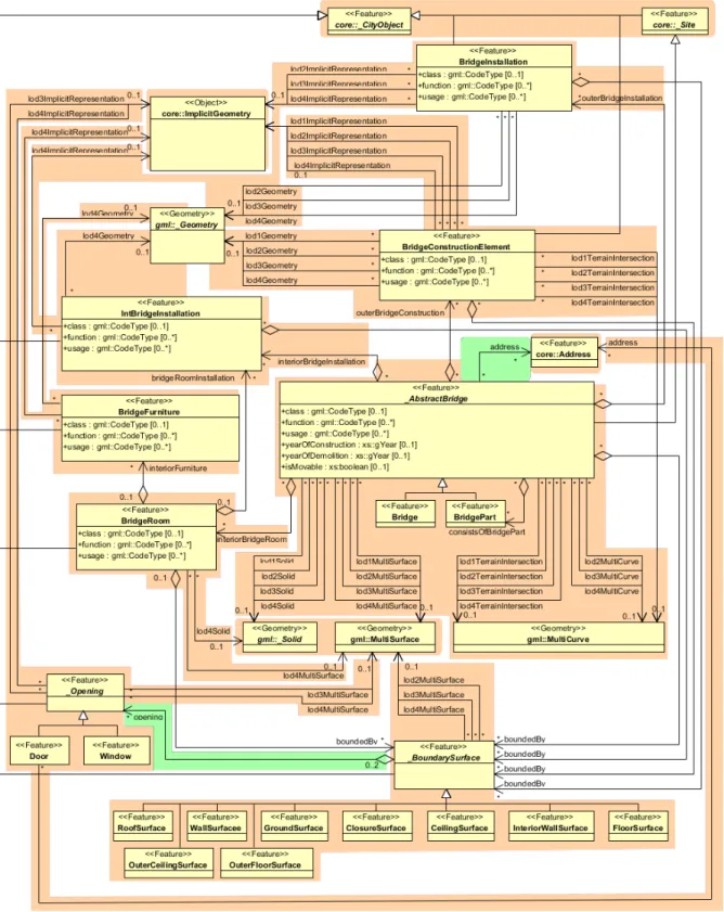
Support for CityGML Application Domain Extensions (ADEs): Semantic 3D city models are employed for many different applications from diverse domains like energetic, environmental, driving, and traffic simulations, as-built building infor- mation modeling (as-built BIM), asset management, and urban information fusion. In order to store and exchange application specific data aligned and integrated with the 3D city objects, the CityGML datamodel can be extended by new feature types, attributes, and relations using the CityGML ADE mechanism. ADEs are specified as (partial) GML application schemas using the modeling language XML Schema.
Starting from release 4.0.0 the 3DCityDB database schema can be dynamically extended by arbitrary ADEs like the Energy ADE, UtilityNetwork ADE, Dynamizer ADE, or national CityGML extensions like IMGeo3D (from The Netherlands). Since ADEs can define an arbitrary number of new elements with all types and numbers of spatial properties, a transformation method has been developed to automatically derive the relational database schemas for arbitrary ADEs from the ADE XML schema files.
Since we intended to follow similar rules in the mapping of the object-oriented ADE
models onto relational models as we used for the (manual) mapping of the CityGML datamodel onto the 3DCityDB core schema, the Chair of Geoinformatics at TUM developed a new transformation method based on graph transformation systems. This method is described in detail in [Yao & Kolbe 2017] and is implemented within the
“ADE Manager” plugin for the Importer/Exporter software tool. It performs a sophisticated analysis of the XML schema files of an ADE, the automatic derivation of additional relational table structures, and the registration of the ADE within the 3DCityDB. Furthermore, SQL scripts are generated for each ADE for e.g. the deletion of ADE objects and attributes from the database. Please note that in order to support also the import and export of CityGML datasets with ADE contents, a Java library for the specific ADE has to be implemented. This library has to perform the handling of the CityGML ADE XML elements and the reading from and writing into the respective ADE database tables using JDBC and SQL. An example how to develop such a Java library is given for a Test ADE in the 3DCityDB github repository1.
Tool for importing and exporting CityGML data: The included Importer/Exporter software tool allows for high performance importing and exporting of CityGML datasets according to CityGML versions 2.0 and 1.0. The tool allows processing of very large datasets (>> 4 GB), even if they include XLinks between CityGML features or XLinks to 3D GML geometry objects. The multi-threaded programming exploits multiprocessor systems or multikernel CPUs to speed up the processing of complex XML-structures, resulting in high performance database access. Objects can be filtered during import or export according to spatial regions (bounding box), their object IDs, feature types, names, and levels of detail. Bounding boxes can be interactively selected using a map window based on OpenStreetMap (OSM). A tiling strategy is implemented in order to support the export of very large datasets. In case of a very high number of texture images they can be automatically distributed in a configurable number of subdirectories in order to avoid large directories with millions of files which can render a Microsoft Windows operating systems unresponsive. The Importer can also validate CityGML files and can be configured to only import valid features. It considers CityGML ADE contents, if the ADEs have been registered in the database and specific Java libraries for reading/writing the ADE contents from/into the ADE database tables is provided (see above). The Importer/Exporter tool can be run in interactive or batch mode.
Tool for exporting visualization models in KML, COLLADA, and glTF formats:
This tool exports city models from the 3D city database in KML, COLLADA, and glTF formats which can directly be viewed and interactively explored in geoinformation systems (GIS) or digital virtual globes like Google Earth or Cesium WebGL Virtual Globe. A tiling strategy is supported where only tiles in the vicinity of the viewer’s location are being loaded facilitating the visualization of even very large 3D city and landscape models. Information balloons for all objects can be configured by the user. The exported models are especially suited to be visualized using the
1 https://github.com/3dcitydb/extension-test-ade
3DCityDB-Web-Map-Client (see below), an Open Source 3D web viewer that is based on the CesiumJS Webglobe framework with many functional extensions.
Tool for exporting data to spreadsheets: The ‘Spreadsheet Generator’ (SPSHG) allows exporting thematic data of 3D objects into tables in CSV and Microsoft Excel format which can be uploaded to a Google Spreadsheet within the Google Document Cloud. For every selected geoobject one row is being exported where the first column always contains the GMLID value of the respective object. The further columns can be selected by the user. This tool can be used to export attribute data from e.g.
buildings like the class, function, usage, roof type, address, and further generic attributes that may contain information like the building energy demand, potential solar energy gain, noise level on the facades etc. The spreadsheet rows can be linked to the visualization model generated by the KML/COLLADA/glTF Exporter. This is illustrated in Appendix B.
Tool for 3D visualization and interactive exploration of 3D models on the web:
The ‘3DCityDB-Web-Map-Client’ is a WebGL-based 3D web viewer which extends the Cesium Virtual Globe to support efficient displaying, caching, prefetching, dynamic loading and unloading of arbitrarily large pre-styled 3D visualization models in the form of tiled KML/glTF datasets generated by the KML/COLLADA/glTF Exporter. It provides an intuitive user interface to facilitate rich interaction with 3D visualization models by means of the enhanced functionalities like highlighting the objects of interests on mouseover and mouseclick as well as hiding, showing, and shadowing them. Moreover, the 3DCityDB-Web-Map-Client is able to link the 3D visualization model with an online spreadsheet (Google Fusion Table) in the Google Cloud and allows viewing and querying the thematic data of every city object according to its GMLID. For details see also [Chaturvedi et al. 2015, Yao et al. 2016].
Web Feature Service (WFS) 2.0: The 3DCityDB comes with an OGC compliant implementation of a basic WFS 2.0 allowing web-based access to the 3D city objects stored in the database. WFS clients can directly connect to this interface and retrieve 3D content for a wide variety of purposes. The implementation currently satisfies the Simple WFS conformance class. The WFS considers CityGML ADE contents, if the ADEs have been registered in the database and specific Java libraries for reading/
writing the ADE contents from/into the ADE database tables is provided (see above).
An implementation of a full, transactional WFS is commercially available from one of the development partners, see Appendix C.
Support of different kinds of multi-representations: Levels of detail, different appearances, (and with Oracle RDBMS only) planning versions and history:
Every geoobject as well as the DTM can be represented in five different resolution or fidelity steps (Levels of Detail, LOD). With increasing LOD, objects do not only obtain a more precise and finer geometry, but do also gain a thematic refinement.
Different appearance data may be stored for each city object. Appearance relates to any surface-based theme, e.g. infrared radiation or noise pollution, not just visual
properties. Consequently, data provided by appearances can be used as input for both presentation and analysis of virtual 3D city models. The database supports feature appearances for an arbitrary number of themes per city model. Each LOD of a feature can have individual appearances. Appearances can represent – among others – textures and georeferenced textures. All texture images can be stored in the database.
The version and history management employs Oracle’s Workspace Manager and, hence, is only available for 3DCityDB instances running on an Oracle RDBMS. It is largely transparent to application programs that work with the database. Procedures saved within the database (Stored Procedures) are provided, which allow for the management of planning alternatives and versions via application programs.
Complex digital terrain models: DTMs may be represented in four different ways in CityGML and therefore also in the 3D city database: regular grids, triangular irregular networks (TINs), 3D mass points and 3D break lines. For every level of detail, a complex DTM consisting of any number of DTM components and DTM types can be defined. Besides, it is possible to combine certain kinds of DTM representations for the same geographic area with each other (e.g. mass points and break lines or grids and break lines). In Oracle Spatial (but not Locator) Grid-based DTMs may be of arbitrary size and are composed from separate tiles to a single overall grid using the Oracle GeoRaster functionality. Please note that the Import/Export tool provides functions to read and write TIN, mass point, and break line DTM components, but not for raster based DTMs. GeoRaster data would have to be imported and exported using other tools from e.g. Oracle, ESRI, or Safe Software.
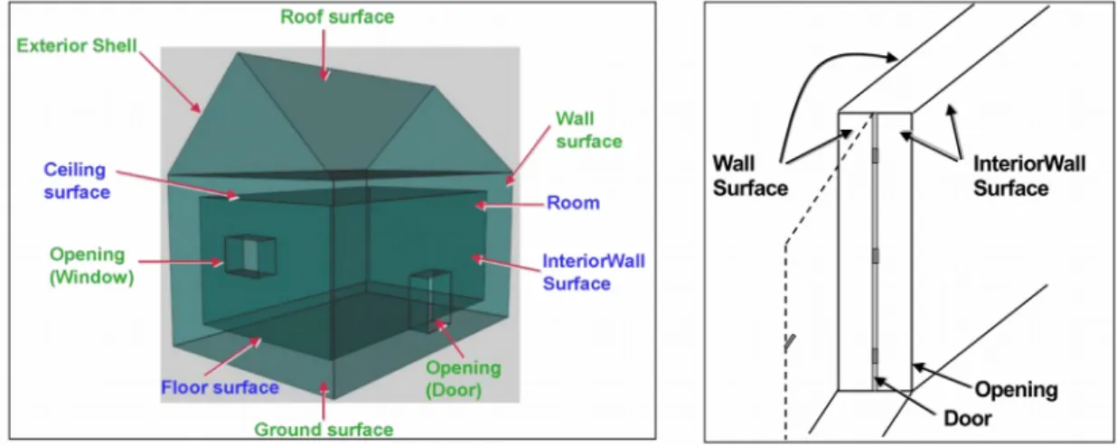
Complex city object modelling: The representation of city objects in the 3D city database ranges from coarse models to geometrically and semantically fine grained structures. The underlying data model is a complete realization of the CityGML data model for the levels of detail (LOD) 0 to 4. For example, buildings can be represented by simple, monolithic objects or can consist of an aggregation of building parts.
Extensions of buildings, like balconies and stairs, can be classified thematically and provided with attributes just as single surfaces can be. LOD4 completes a LOD3 model by adding interior structures for 3D objects. For example, LOD4 buildings are composed of rooms, interior doors, stairs, and furniture. This allows among other things to select the floor space of a building, so that it can later be used e.g. to derive SmartBuildings or to form 3D solids by extrusion [Döllner et al. 2005]. Buildings can be assigned addresses that are also stored in the 3D city database. Their implemen- tation refers to the OASIS xAL Standard, which maps the address formats of the different countries into a unified XML schema. In order to model whole complexes of buildings, single buildings can be aggregated to form special building groups. The same complex modelling applies to the other CityGML feature types like bridges, tunnels, transportation and vegetation objects, and water bodies.
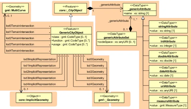
Representation of generic and prototypical 3D objects: Generic objects enable the storage of 3D geoobjects that are not explicitly modelled in CityGML yet, for example dams or city walls, or that are available in a proprietary file format only. This way,
![Figure 6: Example of buildings consisting of one and two building parts [Gröger et al., 2008]](https://thumb-eu.123doks.com/thumbv2/1library_info/4477436.1590516/49.892.182.703.891.1116/figure-example-buildings-consisting-building-parts-gröger-et.webp)
![Figure 15: A relief, consisting of three components and its validity polygons (from: [Plümer et al., 2005])](https://thumb-eu.123doks.com/thumbv2/1library_info/4477436.1590516/58.892.296.593.105.385/figure-relief-consisting-components-validity-polygons-plümer-et.webp)
![Figure 18: LoD2 representation of a transportation complex (from: [Gröger et al., 2008])](https://thumb-eu.123doks.com/thumbv2/1library_info/4477436.1590516/61.892.213.671.104.402/figure-lod-representation-transportation-complex-gröger-et-al.webp)