Version 4. 2
Documentation
2019
3D City
Database
The images on the cover page were provided by:
- Chair of Photogrammetry and Remote Sensing & Chair of Cartography, Technische Universität München
- Geobasisdaten: © Stadtvermessung Frankfurt am Main - IDAC Ltd, UK.
- virtualcitySYSTEMS GmbH, Berlin, Germany
- Chair of Geoinformatics, Technische Universität München. Image created based on master thesis work of Matthias Körner, jointly supervised with HTW Dresden - 3D City Model of Berlin © Berlin partner GmbH
- M.O.S.S. Computer Grafik Systeme GmbH, Taufkirchen, Germany
Versions of software packages
This documentation covers the following versions of the 3D City Database and its tools.
Software package Version
3D City Database 4.0.1, 4.0.0
Importer/Exporter and plugins 4.2.x, 4.1.x, 4.0.0
3DCityDB-Web-Map-Client 1.6.2
Web Feature Service 4.2.x, 4.1.x, 4.0.0
Active participants in development
Name Institution Email
Thomas H. Kolbe Son H. Nguyen Kanishk Chaturvedi Bruno Willenborg Andreas Donaubauer
Chair of Geoinformatics, Technische Universität München
thomas.kolbe@tum.de son.nguyen@tum.de kanishk.chaturvedi@tum.de b.willenborg@tum.de andreas.donaubauer@tum.de Claus Nagel
Zhihang Yao
virtualcitySYSTEMS GmbH, Berlin cnagel@virtualcitysystems.de zyao@virtualcitysystems.de Harald Schulz
Philipp Willkomm György Hudra
M.O.S.S. Computer Grafik Systeme GmbH, Taufkirchen, Germany
hschulz@moss.de pwillkomm@moss.de ghudra@moss.de Felix Kunde Beuth University of Applied Sciences felix-kunde@gmx.de
Participants in earlier developments
The 3D City Database Version 4.0 and its tools are based on earlier versions. During the development phase 2006-2012 at the Institute for Geodesy and Geoinformation Science, TU Berlin, the following individuals contributed to the development:
Name Institution Email
Thomas H. Kolbe Claus Nagel Javier Herreruela Gerhard König Alexandra Lorenz (geb. Stadler) Babak Naderi
Institute for Geodesy and Geoinformation Science, Technische Universität Berlin
Felix Kunde University of Potsdam
During the development phase 2004-2006 at the Institute for Cartography and Geo- information, University of Bonn, the following individuals contributed to the development:
Name Institution Email
Thomas H. Kolbe Lutz Plümer Gerhard Gröger Viktor Stroh Jörg Schmittwilken
Institute for Cartography and Geoinformation, University of Bonn
Andreas Poth Ugo Taddei
lat/lon GmbH, Bonn
Table of Contents
DISCLAIMER ... 11
1 INTRODUCTION ... 13
1.1 Main features of 3DCityDB ... 15
1.2 System and design decisions ... 20
1.3 List of changes between software versions ... 21
Notable changes between 4.0 and 3.3 ... 21
1.4 Development history ... 23
1.5 Acknowledgements ... 24
2 DATA MODELLING AND DATABASE DESIGN ... 27
2.1 Simplification compared to CityGML 2.0.0 ... 27
Multiplicities, cardinalities and recursions ... 27
Data type adaptation ... 28
Project specific classes and class attributes ... 28
Simplified design of GML geometry classes ... 28
2.2 UML class diagram ... 28
Geometric-topological Model ... 29
Implicit Geometry... 30
Appearance Model ... 31
Thematic model ... 34
2.2.4.1 Core Model ... 34
2.2.4.2 Building model ... 36
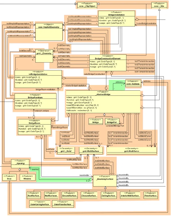
2.2.4.3 Bridge Model ... 39
2.2.4.4 CityFurniture Model ... 42
2.2.4.5 Digital Terrain Model ... 43
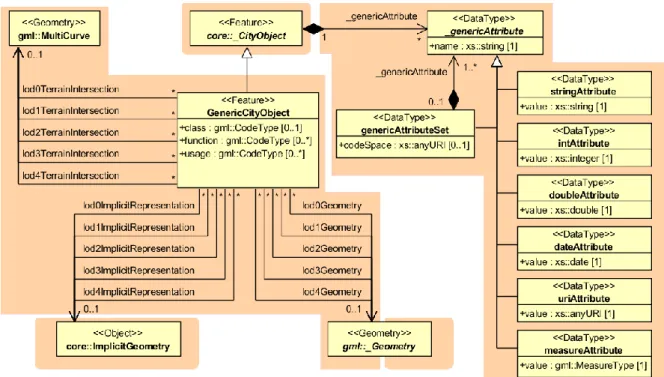
2.2.4.6 Generic Objects and Attributes ... 45
2.2.4.7 LandUse Model ... 47
2.2.4.8 Transportation Model ... 47
2.2.4.9 Tunnel Model ... 49
2.2.4.10Vegetation Model ... 52
2.2.4.11WaterBodies Model ... 53
2.3 Relational database schema ... 55
Mapping rules, schema conventions ... 55
2.3.1.1 Mapping of classes onto tables ... 55
2.3.1.2 Explicit declaration of class affiliation ... 55
Conceptual database structure ... 58
Database schema ... 59
2.3.3.1 Metadata Model ... 59
2.3.3.2 Core Model ... 62
2.3.3.3 Tables for geometry representation ... 64
2.3.3.4 Appearance Model ... 71
2.3.3.5 Building Model ... 76
2.3.3.6 Bridge Model ... 82
2.3.3.7 CityFurniture Model ... 84
2.3.3.8 Digital Terrain Model ... 85
2.3.3.9 Generic Objects and Attributes ... 87
2.3.3.10LandUse Model ... 89
2.3.3.11Transportation Model ... 89
2.3.3.12Tunnel Model ... 91
2.3.3.13Vegetation Model ... 93
2.3.3.14WaterBody Model ... 94
Sequences ... 95
Definition of the CRS for a 3D City Database instance ... 96
3 IMPLEMENTATION AND INSTALLATION ... 99
3.1 System requirements ... 99
3D City Database ... 99
Importer/Exporter Tool ... 99
3.2 Installation of the Importer/Exporter and the 3D City Database SQL Scripts ... 100
3.3 Setting up the database schema ... 102
Shell Scripts ... 102
SQL Scripts... 103
Installation steps on Oracle Databases ... 103
Installation steps on PostgreSQL ... 106
3.4 Working with multiple database schemas ... 108
Create and address database schemas ... 108
Read and write access to a schema ... 109
Schema support in stored procedures ... 109
3.5 Migration from previous major releases ... 110
V2 to V4 Migration on Oracle ... 111
V2 to V4 Migration on PostgreSQL ... 113
V3 to V4 Migration ... 113
3.6 Upgrade between minor releases ... 113
4 STORED PROCEDURES AND ADDITIONAL FEATURES ... 115
4.1 User-defined data types ... 115
4.2 CITYDB_UTIL ... 116
4.3 CITYDB_CONSTRAINT ... 117
4.4 CITYDB_IDX ... 118
4.5 CITYDB_SRS ... 119
4.6 CITYDB_STAT ... 120
4.7 CITYDB_OBJCLASS ... 120
4.8 CITYDB_DELETE ... 120
4.9 CITYDB_ENVELOPE ... 123
5 IMPORTER / EXPORTER ... 125
5.1 Running and using the Importer / Exporter ... 125
5.2 Database connections and operations ... 128
Managing and establishing database connections ... 128
Executing database operations ... 130
5.3 Importing CityGML files ... 137
5.4 Exporting to CityGML ... 142
SQL queries ... 147
XML query expressions... 149
5.4.2.1 <typeNames> parameter ... 149
5.4.2.2 <propertyNames> projection clause ... 151
5.4.2.3 <filter> selection clause ... 152
5.4.2.4 <count> parameter ... 160
5.4.2.5 <lods> parameter ... 161
5.4.2.6 <appearance> parameter ... 162
5.4.2.7 <tiling> parameter ... 163
5.4.2.8 targetSrid attribute ... 164
5.4.2.9 Using address information and 3DCityDB metadata in queries 164 5.4.2.10Using XML queries in batch processes ... 166
5.5 Exporting to KML/COLLADA/glTF ... 167
Support of GenericCityObject having any geometry types ... 174
Loading exported models in Google Earth and Cesium Virtual Globe ... 175
5.6 Preferences ... 178
CityGML import preferences ... 179
5.6.1.1 Continuation ... 179
5.6.1.2 gml:id handling ... 180
5.6.1.3 Address ... 181
5.6.1.4 Appearance ... 183
5.6.1.5 Geometry ... 183
5.6.1.6 Indexes ... 185
5.6.1.7 XML validation ... 186
5.6.1.8 XSL Transformation ... 187
5.6.1.9 Import log ... 188
5.6.1.10Resources ... 189
CityGML export preferences ... 192
5.6.2.1 CityGML version ... 192
5.6.2.2 Tiling options ... 192
5.6.2.3 CityObjectGroup ... 193
5.6.2.4 Address ... 194
5.6.2.5 Appearance ... 195
5.6.2.6 XLinks ... 196
5.6.2.7 XSL Transformation ... 197
5.6.2.8 Resources ... 198
KML/COLLADA/glTF export preferences ... 199
5.6.3.1 General Preferences ... 199
5.6.3.2 Rendering Preferences ... 204
5.6.3.3 Information Balloon Preferences ... 213
5.6.3.4 Altitude/Terrain Preferences ... 220
5.6.3.5 General setting recommendations ... 225
Management of user-defined coordinate reference systems ... 227
General preferences ... 229
5.6.5.1 Cache ... 229
5.6.5.2 Import and export path ... 230
5.6.5.3 Network proxies ... 230
5.6.5.4 API Keys ... 231
5.6.5.5 Logging ... 232
5.6.5.6 Language selection ... 234
5.7 Map window for bounding box selections ... 235
5.8 Using the command line interface (CLI) ... 238
6 IMPORTER / EXPORTER PLUGINS ... 241
6.1 Introduction to the plugin architecture ... 241
6.2 Spreadsheet Generator Plugin (SPSHG) ... 242
Definition ... 242
Plugin installation ... 242
User Interface ... 243
6.2.3.1 Main Parameters ... 243
6.2.3.2 Columns ... 244
6.2.3.3 Content Source ... 249
6.2.3.4 Output ... 249
6.3 ADE Manager Plugin ... 256
Definition ... 256
Plugin installation ... 256
User Interface ... 258
6.3.3.1 ADE Registration ... 258
6.3.3.2 ADE Transformation ... 261
Workflow of extending the Import/Export Tool ... 264
7 WEB FEATURE SERVICE ... 271
7.1 System requirements ... 271
7.2 Installation ... 272
7.3 Configuring the Web Feature Service ... 274
Database settings ... 274
Capabilities settings ... 277
Feature type settings ... 278
Operations settings ... 279
Postprocessing settings ... 280
Server settings... 281
Cache settings ... 282
Constraints settings ... 282
Logging settings ... 283
7.4 Using the Web Feature Service ... 284
Basic functionality ... 284
7.4.1.1 WFS operations ... 284
7.4.1.2 Service URL ... 285
7.4.1.3 Service bindings ... 286
7.4.1.4 CityGML feature types ... 286
7.4.1.5 Exception reports ... 287
GetCapabilities operation ... 287
DescribeFeatureType operation ... 288
ListStoredQueries operation ... 290
DescribeStoredQuery operation ... 291
GetFeature operation ... 293
7.5 Web-based WFS client ... 295
8 3DCITYDB-WEB-MAP-CLIENT ... 297
8.1 System requirements ... 298
8.2 Installation and configuration ... 298
8.3 Using the 3D web client ... 300
Overview of the relevant features and functionalities ... 300
Handling KML/glTF models with online spreadsheet ... 305
Handling Web Map Service data ... 312
Handling Digital Terrain Models ... 314
Interaction with 3D objects ... 316
Mobile Support Extension ... 322
Using the 3D Web Client from the 3DCityDB homepage ... 324
9 3DCITYDB DOCKER IMAGES ... 325
9.1 Getting started ... 325
9.2 Further images ... 326
10 REFERENCES ... 327
APPENDIX A CHANGELOG ... 331
A.1 3D City Database relational schema ... 331
A.1.1 General changes ... 331
A.2 3D City Database scripts ... 331
A.3 3D City Database stored procedures ... 332
A.3.1 General changes ... 332
A.3.2 UTIL package ... 332
A.3.3 IDX package ... 332
A.3.4 SRS package ... 332
A.3.5 STAT package ... 332
A.3.6 DELETE package ... 332
A.3.7 DELETE_BY_LINEAGE package ... 333
A.3.8 ENVELOPE package ... 333
A.4 3D City Database Importer/Exporter ... 333
A.4.1 General changes ... 333
A.4.2 CityGML import ... 333
A.4.3 CityGML export ... 334
A.4.4 KML/COLLADA/glTF export ... 334
A.5 Web Feature Service ... 334
A.6 3D Web Map Client ... 335
APPENDIX B 3DCITYDB @ TU MÜNCHEN ... 337
B.1 Interactive Cloud-based 3D Webclient ... 337
B.2 Research Projects in which 3DCityDB is being used ... 338
B.3 Current and future work on 3DCityDB ... 338
APPENDIX C 3DCITYDB @ VIRTUALCITYSYSTEMS ... 339
C.1 virtualcityDATABASE ... 339
C.2 virtualcitySUITE – The 3D City Platform ... 340
APPENDIX D 3DCITYDB @ M.O.S.S. ... 341
D.1 novaFACTORY at a glance ... 341
D.2 novaFACTORY 3D GDI ... 342
Disclaimer
The 3D City Database (3DCityDB) version 4.0 has been developed in collaboration of the Chair of Geoinformatics, Technische Universität München (TUMGI), virtualcitySYSTEMS GmbH, and M.O.S.S. Computer Grafik System GmbH. 3DCityDB is free and Open Software licensed under the Apache License, Version 2.0. See the file LICENSE file shipped together with the software for more details. You may obtain a copy of the license at http://www.apache.org/licenses/LICENSE-2.0.
Please note that releases of the software before version 3.3.0 continue to be licensed under GNU LGPL 3.0. To request a previous release of the 3D City Database under Apache License 2.0 create a GitHub issue at https://github.com/3dcitydb.
THE SOFTWARE IS PROVIDED BY TUMGI "AS IS" AND "WITH ALL FAULTS."
TUMGI MAKES NO REPRESENTATIONS OR WARRANTIES OF ANY KIND CONCERNING THE QUALITY, SAFETY OR SUITABILITY OF THE SOFTWARE, EITHER EXPRESSED OR IMPLIED, INCLUDING WITHOUT LIMITATION ANY IMPLIED WARRANTIES OF MERCHANTABILITY, FITNESS FOR A PARTICULAR PURPOSE, OR NON-INFRINGEMENT.
TUMGI MAKES NO REPRESENTATIONS OR WARRANTIES AS TO THE TRUTH, ACCURACY OR COMPLETENESS OF ANY STATEMENTS, INFORMATION OR MATERIALS CONCERNING THE SOFTWARE THAT IS CONTAINED ON AND WITHIN ANY OF THE WEBSITES OWNED AND OPERATED BY TUMGI.
IN NO EVENT WILL TUMGI BE LIABLE FOR ANY INDIRECT, PUNITIVE, SPECIAL, INCIDENTAL OR CONSEQUENTIAL DAMAGES HOWEVER THEY MAY ARISE AND EVEN IF TUMGI HAVE BEEN PREVIOUSLY ADVISED OF THE POSSIBILITY OF SUCH DAMAGES.
1 Introduction
Virtual 3D city and landscape models are provided for an increasing number of cities, regions, states, and even countries. They are created and maintained by public authorities like national and state mapping agencies as well as by cadastre institutions and private companies. The 3D topography of urban and rural areas is essential for both visual exploration and a range of different analyses in, for example, the urban planning, environmental, energy, transportation, and facility management sectors.
3D city models are nowadays used as an integrative information backbone representing the relevant urban entities along with their spatial, semantic, and visual properties. They are often created and maintained with full coverage of entire cities and even countries, i.e. all real world objects of a specific type like buildings, roads, trees, water bodies, and the terrain are explicitly represented. In most cases the 3D city model objects have well-defined identifiers, which are kept stable during the lifetime of the real world objects and their virtual counterparts. Such complete 3D models are a good basis to organize different types of data and sensors within Smart City projects as they build a stable platform for information linking and enrichment.
In order to establish a common understanding and interpretation of the urban objects and to achieve interoperable access and exchange of complete 3D models including the geometric, topologic, visual, and semantic data, the Open Geospatial Consortium (OGC) has issued the CityGML standard [Kolbe 2009]. CityGML defines a feature catalogue and data model for the most relevant 3D topographic elements like buildings, bridges, tunnels, roads, railways, vegetation, water bodies, etc. The data model is mapped to an XML-based exchange format using OGC’s Geography Markup Language (GML).
The 3D City Database (3DCityDB) is a free Open Source package consisting of a database schema and a set of software tools to import, manage, analyse, visualize, and export virtual 3D city models according to the CityGML standard. The database schema results from a mapping of the object oriented data model of CityGML 2.0 to the relational structure of a spatially-enhanced relational database management system (SRDBMS). The 3DCityDB supports the commercial SRDBMS Oracle (with ‘Spatial’ or ‘Locator’ license options) and the Open Source SRDBMS PostGIS (which is an extension to the free RDBMS PostgreSQL).
3DCityDB makes use of the specific representation and processing capabilities of the SRDBMS regarding the spatial data elements. It can handle also very large models in multiple levels of details consisting of millions of 3D objects with hundreds of millions of geometries and texture images.
3DCityDB is in use in real life production systems in many places around the world and is also being used in a number of research projects. For example, the cities of Berlin, Potsdam, Munich, Frankfurt, Zurich, Rotterdam, Singapore all keep and manage their virtual 3D city models within an instance of 3DCityDB. The companies virtualcitySYSTEMS (VCS) and M.O.S.S., who are also partners in development, use 3DCityDB at the core of their commercial products and services to create, maintain, visualize, transform, and export virtual
3D city models (see Appendix B, Appendix C, and Appendix D for examples how and where TUM, virtualcitySYSTEMS, and M.O.S.S. employ 3DCityDB in their projects). Furthermore, the state mapping agencies of all 16 states in Germany store and manage the state-wide collected 3D building models in CityGML LOD1 and LOD2 using 3DCityDB. In 2012 the previous version of 3DCityDB and the developer team received the Oracle Spatial Excellence Award, issued by Oracle USA.
Since 3DCityDB is based on CityGML, interoperable data access from user applications to the database can be achieved in at least two ways:
1) by using the included high-performance CityGML Import/Export tool or the included basic Web Feature Service 2.0 in order to exchange the data in CityGML format (Version 2.0 or 1.0), and
2) by directly accessing the database tables whose relational structures are fully explained in detail within this document. It is easy to enrich a 3D city model by adding information to the database tables in some user application (using e.g. the database APIs of programming language like C++, Java, Python, or of ETL tools like the Feature Manipulation Engine from Safe Software). The enriched dataset then can be exchanged or archived by exporting the city model to CityGML without information loss. Analogously, 3DCityDB can be used to import a CityGML dataset and then access and work with the city model by directly accessing the database tables from some application programs or ETL software.
The Import/Export tool also provides functionalities for the direct export of 3D visualization models in KML, COLLADA, and glTF formats. A tiling strategy is supported which allows to visualize even very large 3D city and landscape models in geoinformation systems (GIS) or digital virtual globes like Google Earth or CesiumJS Virtual Globe. The Import/Export tool comes with an API to create further importers, exporters, and database administration tools.
One export plugin coming with the software installer package is the so-called ‘Spreadsheet Generator Plugin’ (SPSHG) which allows to export thematic data of 3D objects into tables in CSV and Microsoft Excel format that can be easily uploaded to and published as online spreadsheets, for instance, within the Google Cloud. Starting from release 3.3.0, the 3DCityDB software package comes with the CesiumJS-based 3D viewer called “3DCityDB- Web-Map-Client” which can link the 3D visualization models with online spreadsheets and facilitates interactive visualization and exploration of 3D city models over the Internet within web browsers on desktop and mobile computers. The most significant new functionality in release 4.0.0 is the support of CityGML Application Domain Extensions (ADEs). ADEs extend the CityGML datamodel by domain specific object types, attributes, and relations.
This document describes the design and the components of the 3D City Database as well as their usage for the new major release 4.0.0 which has been developed and implemented by the three partners in development, namely the Chair of Geoinformatics at Technische Universität München, virtualcitySYSTEMS, and M.O.S.S. The development is continuing the previous work carried out at the Institute for Geodesy und Geoinformation Science (IGG) of the Berlin University of Technology and the Institute for Cartography and Geoinformation (IKG) of the University of Bonn.
This document has been completely reworked, integrated, extended, and edited from the previous 3DCityDB documentations (version 3.3.0, version 2.0.1, and the documentation addendum on 3DCityDB version 2.1.0 and the Importer/Exporter tool version 1.6.0). Some figures and texts are cited from the OpenGIS City Geography Markup Language (CityGML) Encoding Standard, Version 2.0.0 [Gröger et al. 2012].
1.1 Main features of 3DCityDB
Many (but not all) of the features referring to object modelling and representation are implied by following the CityGML standard 2.0.0 issued by the Open Geospatial Consortium.
CityGML 2.0.0 and 1.0.0 compliant database: The implementation defines the classes and relations for the most relevant topographic objects in cities and regional models with respect to their geometrical, topological, semantical, and appearance properties. Included are generalization hierarchies between thematic classes, aggregations, relations between objects, and spatial properties. These thematic information go beyond graphic exchange formats and allow to employ virtual 3D city models for sophisticated analysis tasks in different application domains.
Implementation on the basis of a spatially-enhanced relational database manage- ment system (Oracle 10G R2 or higher with Spatial/Locator option; PostgreSQL 9.1 or higher with PostGIS extension 2.0 or higher): For the representation of all vector and grid geometry the built-in data types provided by the SRDBMS are used exclusively. This way, special solutions are avoided and different geoinformation systems, CAD/BIM systems, and ETL software systems can directly access (read and write) the geometry objects stored in the SRDBMS.
Support for CityGML Application Domain Extensions (ADEs): Semantic 3D city models are employed for many different applications from diverse domains like energetic, environmental, driving, and traffic simulations, as-built building infor- mation modeling (as-built BIM), asset management, and urban information fusion. In order to store and exchange application specific data aligned and integrated with the 3D city objects, the CityGML datamodel can be extended by new feature types, attributes, and relations using the CityGML ADE mechanism. ADEs are specified as (partial) GML application schemas using the modeling language XML Schema.
Starting from release 4.0.0 the 3DCityDB database schema can be dynamically extended by arbitrary ADEs like the Energy ADE, UtilityNetwork ADE, Dynamizer ADE, or national CityGML extensions like IMGeo3D (from The Netherlands). Since ADEs can define an arbitrary number of new elements with all types and numbers of spatial properties, a transformation method has been developed to automatically derive the relational database schemas for arbitrary ADEs from the ADE XML schema files.
Since we intended to follow similar rules in the mapping of the object-oriented ADE models onto relational models as we used for the (manual) mapping of the CityGML datamodel onto the 3DCityDB core schema, the Chair of Geoinformatics at TUM developed a new transformation method based on graph transformation systems. This
method is described in detail in [Yao & Kolbe 2017] and is implemented within the
“ADE Manager” plugin for the Importer/Exporter software tool. It performs a sophisticated analysis of the XML schema files of an ADE, the automatic derivation of additional relational table structures, and the registration of the ADE within the 3DCityDB. Furthermore, SQL scripts are generated for each ADE for e.g. the deletion of ADE objects and attributes from the database. Please note that in order to support also the import and export of CityGML datasets with ADE contents, a Java library for the specific ADE has to be implemented. This library has to perform the handling of the CityGML ADE XML elements and the reading from and writing into the respective ADE database tables using JDBC and SQL. An example how to develop such a Java library is given for a Test ADE in the 3DCityDB github repository1.
Tool for importing and exporting CityGML data: The included Importer/Exporter software tool allows for high performance importing and exporting of CityGML datasets according to CityGML versions 2.0 and 1.0. The tool allows processing of very large datasets (>> 4 GB), even if they include XLinks between CityGML features or XLinks to 3D GML geometry objects. The multi-threaded programming exploits multiprocessor systems or multikernel CPUs to speed up the processing of complex XML-structures, resulting in high performance database access. Objects can be filtered during import or export according to spatial regions (bounding box), their object IDs, feature types, names, and levels of detail. Bounding boxes can be interactively selected using a map window based on OpenStreetMap (OSM). A tiling strategy is implemented in order to support the export of very large datasets. In case of a very high number of texture images they can be automatically distributed in a configurable number of subdirectories in order to avoid large directories with millions of files which can render a Microsoft Windows operating systems unresponsive. The Importer can also validate CityGML files and can be configured to only import valid features. It considers CityGML ADE contents, if the ADEs have been registered in the database and specific Java libraries for reading/writing the ADE contents from/into the ADE database tables is provided (see above). The Importer/Exporter tool can be run in interactive or batch mode.
Tool for exporting visualization models in KML, COLLADA, and glTF formats:
This tool exports city models from the 3D city database in KML, COLLADA, and glTF formats which can directly be viewed and interactively explored in geoinformation systems (GIS) or digital virtual globes like Google Earth or Cesium WebGL Virtual Globe. A tiling strategy is supported where only tiles in the vicinity of the viewer’s location are being loaded facilitating the visualization of even very large 3D city and landscape models. Information balloons for all objects can be configured by the user. The exported models are especially suited to be visualized using the 3DCityDB-Web-Map-Client (see below), an Open Source 3D web viewer that is based on the CesiumJS Webglobe framework with many functional extensions.
1 https://github.com/3dcitydb/extension-test-ade
Tool for exporting data to spreadsheets: The ‘Spreadsheet Generator’ (SPSHG) allows exporting thematic data of 3D objects into tables in CSV and Microsoft Excel format which can be uploaded to a Google Spreadsheet within the Google Document Cloud. For every selected geoobject one row is being exported where the first column always contains the GMLID value of the respective object. The further columns can be selected by the user. This tool can be used to export attribute data from e.g.
buildings like the class, function, usage, roof type, address, and further generic attributes that may contain information like the building energy demand, potential solar energy gain, noise level on the facades etc. The spreadsheet rows can be linked to the visualization model generated by the KML/COLLADA/glTF Exporter. This is illustrated in Appendix B.
Tool for 3D visualization and interactive exploration of 3D models on the web:
The ‘3DCityDB-Web-Map-Client’ is a WebGL-based 3D web viewer which extends the Cesium Virtual Globe to support efficient displaying, caching, prefetching, dynamic loading and unloading of arbitrarily large pre-styled 3D visualization models in the form of tiled KML/glTF datasets generated by the KML/COLLADA/glTF Exporter. It provides an intuitive user interface to facilitate rich interaction with 3D visualization models by means of the enhanced functionalities like highlighting the objects of interests on mouseover and mouseclick as well as hiding, showing, and shadowing them. Moreover, the 3DCityDB-Web-Map-Client is able to link the 3D visualization model with an online spreadsheet (Google Fusion Table) in the Google Cloud and allows viewing and querying the thematic data of every city object according to its GMLID. For details see also [Chaturvedi et al. 2015, Yao et al. 2016].
Web Feature Service (WFS) 2.0: The 3DCityDB comes with an OGC compliant implementation of a basic WFS 2.0 allowing web-based access to the 3D city objects stored in the database. WFS clients can directly connect to this interface and retrieve 3D content for a wide variety of purposes. The implementation currently satisfies the Simple WFS conformance class. The WFS considers CityGML ADE contents, if the ADEs have been registered in the database and specific Java libraries for reading/
writing the ADE contents from/into the ADE database tables is provided (see above).
An implementation of a full, transactional WFS is commercially available from one of the development partners, see Appendix C.
Support of different kinds of multi-representations: Levels of detail, different appearances, (and with Oracle RDBMS only) planning versions and history:
Every geoobject as well as the DTM can be represented in five different resolution or fidelity steps (Levels of Detail, LOD). With increasing LOD, objects do not only obtain a more precise and finer geometry, but do also gain a thematic refinement.
Different appearance data may be stored for each city object. Appearance relates to any surface-based theme, e.g. infrared radiation or noise pollution, not just visual properties. Consequently, data provided by appearances can be used as input for both presentation and analysis of virtual 3D city models. The database supports feature
appearances for an arbitrary number of themes per city model. Each LOD of a feature can have individual appearances. Appearances can represent – among others – textures and georeferenced textures. All texture images can be stored in the database.
The version and history management employs Oracle’s Workspace Manager and, hence, is only available for 3DCityDB instances running on an Oracle RDBMS. It is largely transparent to application programs that work with the database. Procedures saved within the database (Stored Procedures) are provided, which allow for the management of planning alternatives and versions via application programs.
Complex digital terrain models: DTMs may be represented in four different ways in CityGML and therefore also in the 3D city database: regular grids, triangular irregular networks (TINs), 3D mass points and 3D break lines. For every level of detail, a complex DTM consisting of any number of DTM components and DTM types can be defined. Besides, it is possible to combine certain kinds of DTM representations for the same geographic area with each other (e.g. mass points and break lines or grids and break lines). In Oracle Spatial (but not Locator) Grid-based DTMs may be of arbitrary size and are composed from separate tiles to a single overall grid using the Oracle GeoRaster functionality. Please note that the Import/Export tool provides functions to read and write TIN, mass point, and break line DTM components, but not for raster based DTMs. GeoRaster data would have to be imported and exported using other tools from e.g. Oracle, ESRI, or Safe Software.
Complex city object modelling: The representation of city objects in the 3D city database ranges from coarse models to geometrically and semantically fine grained structures. The underlying data model is a complete realization of the CityGML data model for the levels of detail (LOD) 0 to 4. For example, buildings can be represented by simple, monolithic objects or can consist of an aggregation of building parts.
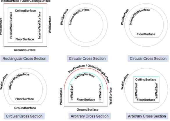
Extensions of buildings, like balconies and stairs, can be classified thematically and provided with attributes just as single surfaces can be. LOD4 completes a LOD3 model by adding interior structures for 3D objects. For example, LOD4 buildings are composed of rooms, interior doors, stairs, and furniture. This allows among other things to select the floor space of a building, so that it can later be used e.g. to derive SmartBuildings or to form 3D solids by extrusion [Döllner et al. 2005]. Buildings can be assigned addresses that are also stored in the 3D city database. Their implemen- tation refers to the OASIS xAL Standard, which maps the address formats of the different countries into a unified XML schema. In order to model whole complexes of buildings, single buildings can be aggregated to form special building groups. The same complex modelling applies to the other CityGML feature types like bridges, tunnels, transportation and vegetation objects, and water bodies.
Representation of generic and prototypical 3D objects: Generic objects enable the storage of 3D geoobjects that are not explicitly modelled in CityGML yet, for example dams or city walls, or that are available in a proprietary file format only. This way, files from other software systems like architecture or computer graphics programs can
be imported directly into the database (without interpretation). However, application systems that would like to use these data must be able to interpret the corresponding file formats after retrieving them back from the 3D geodatabase.
Prototypical objects are used for memory-efficient management of objects that occur frequently in the city model and that do not differ with respect to geometry and appearance. Examples are elements of street furniture like lanterns, road signs or benches as well as vegetation objects like shrubs, certain tree types etc. Every instance of a prototypical object is represented by a reference to the prototype, a base point and a transformation matrix for scaling, rotating and translating the prototype.
The geometries (and appearances like textures, colors etc.) of generic objects as well as prototypes can be stored either using the geometry datatype of the spatial database management system (Oracle Spatial/Locator or PostGIS) or in proprietary file formats.
In the latter case a single file may be saved for every object, but the file type (MIME type), the coordinate transformation matrix that is needed to integrate the object into the world coordinate reference system (CRS) and the target CRS have to be specified.
Extendable object attribution: All objects in the 3D geodatabase can be augmented with an arbitrary number of additional generic attributes. This way, it is possible to add further thematic information as well as further spatial properties to the objects at any time. In combination with the concept of generic 3D objects this provides a highly flexible storage option for object types which are not explicitly defined in the CityGML standard. Every generic attribute consists of a triple of attribute name, data type, and value. Supported data types are: string; integer and floating-point numbers;
date; time; binary object (BLOB, e.g. for storing a file); geometry object according to the specific geometry data type of Oracle or PostGIS respectively; simple, composite, or aggregate 3D solids or surfaces. Please note that generic attributes of type BLOB or geometry are not allowed as generic attributes in CityGML (and will, thus, not be exported by the CityGML exporter). However, it may be useful to store binary data associated with the individual city objects, for example, to store derived 3D computer graphics representations.
Free, also recursive grouping of geoobjects: Geoobjects can be grouped arbitrarily.
The aggregates can be named and may also be provided with an arbitrary number of generic attributes (see above). Object groups may also contain object groups, which leads to nested aggregations of arbitrary depth. In addition, for every object of an aggregation, its role in the group can be specified explicitly (qualified association).
External references for all geoobjects: All geoobjects can be provided with an arbitrary number of references to corresponding objects in external data sources (i.e.
hyperlinks / linked data). For example, in case of building objects this allows to store e.g. the IDs of the corresponding objects in official cadasters, digital landscape models (DLM), or Building Information Models (BIM). Each reference consists of an URI to the external data store or database and the corresponding object ID or URI within that external data store or database.
Flexible 3D geometries: The geometry of most 3D objects can be represented through the combination of solids and surfaces as well as any - also recursive - aggregation of these elements. Each surface may has attached different textures and colors on both its front and back face. It may also comprise information on transparency. Additional geometry types (any geometry type supported by the spatial database management system Oracle Spatial/Locator or PostGIS) can be added to the geoobjects by using generic attributes.
Open Source and Platform Independence: The entire software is freely accessible to the interested public. The 3DCityDB is licensed under the Apache License, Version 2.0, which allows including 3DCityDB in commercial systems. You may obtain a copy of the Apache License at http://www.apache.org/licenses/LICENSE-2.0. Both the Importer/Exporter tool and the Web Feature Service are implemented in Java and can be run on different platforms and operating systems.
Docker support: We now provide Docker images for 1) a complete 3DCityDB installation pre-installed within a PostGIS SRDBMS, 2) a webserver with an installed 3DCityDB-Web-Map-Client, 3) a 3DCityDB WFS. We also provide a Docker- compose script to launch all three Docker containers in a linked way with just a single command. Details are given in Section 9 and in the respective github repositories2. Docker is a runtime environment for virtualization. Docker encapsulates individual software applications in so-called containers, which are – in contrast to virtual machines – light-weight and can be deployed, started and stopped very quickly and easily. Using our Docker images a 3DCityDB can be installed by a single command.
1.2 System and design decisions
The 3D City Database is implemented as a relational database schema using the spatial datatypes provided by a spatially-enhanced relational database management system (SRDBMS). Above, external software applications and database stored procedures are provided working on this database schema. Since only Oracle with the Spatial or Locator licensing option (10G R2 or higher) and PostgreSQL (9.3 or higher) with PostGIS extension (2.0 or higher) offer comprehensive support for 3D spatial data, the 3D City Database schema is being provided for these two systems only.
In addition to the general advantages arising from the usage of a widely used relational database management system (RDBMS), both Oracle Spatial/Locator and PostgreSQL/
PostGIS offer some important performance characteristics that allow an efficient implemen- tation of the required functionalities:
Both RDBMS support spatial data types with coordinates ranging from 2D to 4D.
Spatial indexes and filters can be 2D or 3D allowing for efficient spatial selections in very large city models. Furthermore, the spatial data types are supported by a number
2 https://github.com/tum-gis
of commercial and Open Source GIS that provide a database connection as for example ESRI’s ArcGIS/ArcSDE or Safe Software’s Feature Manipulation Engine (FME). This enables such systems to directly access the data stored in the 3D geodatabase.
Rules can be implemented using stored procedures and trigger mechanisms which propagate updates of objects to likewise affected objects in the database (transparent for the user).
The data model of the 3D City Database is based on the CityGML 2.0 standard. The object- oriented data model of CityGML has been mapped to a purely relational data model with the exception that geometry objects are mapped to the spatial datatypes provided by the SDBMS.
In order to achieve high performance for data manipulations and queries the mapping was done manually with a number of optimizations. A few simplifying assumptions where made regarding the usage of the CityGML concepts in the real world helping to increase performance. These are documented in chapter 2.1.
Surface-based geometries like Polygons, TINs, MultiSurfaces as well as Solids are stored in a special way: they are decomposed into their primitive surfaces and each surface is stored as an individual tuple in one big surface table. The reason for this is that each surface can be assigned multiple appearances (e.g. textures) in CityGML and, thus, each appearance must be explicitly linkable to the corresponding surface. For Solids also the solid geometry objects are stored in addition to their decomposed boundary surfaces allowing to apply spatial operations on them like the computation of the volume.
The provided software tools like the Importer/Exporter application are implemented in the Java language in order to be platform independent. The tools have been confirmed to run under Microsoft Windows, Linux, and Apple Mac OS X. High performance is achieved by exploiting multi-threading on multiprocessor or multi-core CPU systems.
1.3 List of changes between software versions Notable changes between 4.0 and 3.3
New features and functionalities:
Importer/Exporter 4.2: Reworked Plugin API to support non-GUI plugins.
Importer/Exporter 4.2: Property projections can now also be defined for abstract feature types.
Importer/Exporter 4.1: Added support for using SQL and XML queries for CityGML exports to be able express more flexible and complex filter conditions
Importer/Exporter 4.1: Added support for importing CityGML data from (G)ZIP files and exporting CityGML content to (G)ZIP files
Importer/Exporter 4.1: OSM Nominatim is now used as default geocoder for the map window. Google Map API services can still be used for the map window and for KML/COLLADA exports but require an API key.
Management and storage of arbitrary CityGML ADEs with the 3DCityDB, the Importer/Exporter ADE Manager Plugin and the 3DCityDB WFS
New 3DCityDB Docker images to support continuous integration workflows
New metadata tables ADE, SCHEMA, SCHEMA_REFERENCING and SCHEMA_TO_OBJECTCLASS for registering CityGML ADEs
New prefilled metadata table AGGREGATION_INFO that supports the automatic generation of DELETE and ENVELOPE scripts
New function to create entries in USER_SDO_GEOM_METADATA view (Oracle)
Function objectclass_id_to_table_name now has a counterpart:
table_name_to_objectclass_ids returning an array of objectclass ids (CITYDB_OBJCLASS package in Oracle, part of a data schema in PostgreSQL)
New database procedures to enable/disable foreign key constraints to speed up bulk write operations (CITYDB_CONSTRAINT package in Oracle, part of the citydb_pkg schema in PostgreSQL)
New SQL script to create additional data schemas in one database (PostgreSQL)
New shell and SQL scripts to grant read-only or full read-write access to another schema.
Importer/Exporter can connect to different database schemas with the same user
Enabling XSL transformations on CityGML imports and exports as well as WFS responses
New database operation panel to change the spatial reference system used in the database (incl. optional coordinate transformation)
New LoD filter for CityGML exports
3DCityDB WFS allows for exporting into the CityJSON format Improved and updated features and functionalities:
Moved interactive prompts from SQL to batch/shell scripts for better setup automation
Added OBJECTCLASS_ID column to all feature tables to distinguish objects from CityGML ADEs. Also extended OBJECTCLASS table by more feature-specific details and inserted new entries for feature properties such as geometry, generic attributes etc.
Improved performance on stored procedures by reducing amount of dynamic SQL.
Therefore, schema_name parameter has been removed from DELETE and ENVELOPE scripts. Under PostgreSQL these scripts (as well as the INDEX_TABLE) are now part of a data schema such as citydb.
DELETE and ENVELOPE are now generated automatically in order to deal with schema changes introduced by ADEs. Therefore, the function prefix has been shortened to del_ and env_ not hit the character limit under Oracle,
The CITYDB_DELETE_BY_LINEAGE package has been removed. The only function left is del_cityobjects_by_lineage which is now part of the DELETE package
Database migration scripts for version 2.1.0 or version 3.3.0 to version 4.0.0
Switching from Ant to Gradle as the new build system for the Importer/Exporter tools
Allow import of CityGML files with flat hierarchies between city objects
Added support for importing gml:MultiGeometry objects containing only polygons
Added support for exporting to glTF v2.0
3DCityDB WFS now supports CORS and provides a KVP over HTTP GET endpoint for every operation simplifying the integration with GIS and ETL software such as FME
1.4 Development history
The development of the 3D City Database was always closely related to the development of the CityGML standard [Kolbe & Gröger 2003]. It was started back in 2003 by Dr. Kolbe and Prof. Plümer at the Institute for Cartography and Geoinformation at University of Bonn. In the period from November 2003 to December 2005 the official virtual 3D city model of Berlin, commissioned by The Berlin Senate and Berlin Partner GmbH, was developed within a pilot project funded by the European Union [Plümer et al. 2005, Berlin 3D]. Since then, the model has been playing a central role in the three-dimensional spatial data infrastructure of Berlin and opened up a multitude of applications for the public and private sector alike. As an example the virtual city model is successfully used for presentation of the business location, its urban development combined with application related information to politicians, investors, and the public in order to support civic participation, provide access to decision-making content, assist in policy-formulation, and control implementation processes [Döllner et al.
2006]. 3DCityDB was key in demonstrating the real world usage of CityGML to the Open Geospatial Consortium on the one hand, and the practical usability and versatility of CityGML to the city of Berlin on the other hand. This first development phase was carried out by University of Bonn in collaboration with the company lat/lon GmbH. Oracle Spatial was the only supported SDBMS in that phase and the next (3DCityDB Versions 0.2 up to 1.3).
Within the framework Europäische Fonds für regionale Entwicklung (EFRE II) the project Geodatenmanagement in der Berliner Verwaltung – Amtliches 3D-Stadtmodell für Berlin allowed for upgrading the official 3D city model based on the former CityGML specification draft 0.4.0 in the year 2007. The developments were carried out by the Institute for Geodesy und Geoinformation Science (IGG) of the Berlin University of Technology (where Kolbe became full professor for Geoinformation Science in 2006) on behalf of the Berliner Senatsverwaltung für Wirtschaft, Arbeit und Frauen and the Berlin Partner GmbH (former Wirtschaftsförderung Berlin International). The relational database model (3DCityDB versions 1.4 up to 1.8) was implemented and evaluated in cooperation with 3DGeo GmbH (later bought by Autodesk GmbH) in Potsdam. A special database interface for LandXPlorer was provided by 3DGeo / Autodesk. Later on, a first version of the Java based CityGML Importer/Exporter was developed [Stadler et al. 2009].
In August 2008, CityGML 1.0.0 became an adopted standard of the Open Geospatial Consortium (OGC). In the follow-up project Digitaler Gestaltplan Potsdam starting in 2010 the 3DCityDB version 2 was developed which brought support for all CityGML 1.0.0 feature types. The KML/COLLADA exporter was added as well as a ‘Matching’ plugin. This project
was carried out by IGG of TU Berlin on behalf of and in collaboration with the company virtualcitySYSTEMS (VCS) in Berlin. In 2012 the developer team at TU Berlin received the Oracle Spatial Excellence Award for Education and Research from Oracle USA for our work on 3DCityDB. Also in 2012 3DCityDB was ported to PostgreSQL/PostGIS by Felix Kunde, a master student from the University of Potsdam, who did his master thesis in collaboration with IGG [Kunde 2013].
In August 2012, CityGML 2.0.0 became an adopted standard of the Open Geospatial Consor- tium (OGC). In September 2012, Prof. Kolbe moved from IGG, TU Berlin to the Chair of Geoinformatics at Technische Universität München (TUM). The companies virtualcity- SYSTEMS GmbH in Berlin and M.O.S.S. Computer Grafik Systeme GmbH in Taufkirchen (near Munich) have also been using the 3D City Database in their commercial projects for a number of years. In this context, the Chair of Geoinformatics at TUM and the companies virtualcitySYSTEMS and M.O.S.S. signed an official collaboration agreement on the joint further development of 3DCityDB and its tools. The work on the new major release version 3.0.0 began in 2013 when Dr. Nagel finished his PhD and joined the company VCS. In Version 3.3.0 the new 3D web client was being added. The webclient was developed by Zhihang Yao with contributions from Kanishk Chaturvedi and Son Nguyen. In 2015 Zhihang Yao and Kanishk Chaturvedi were awarded the first price in the 'Best Students Contribution' of the 'Web3D city modeling competition' under the annual ACM SIGGRAPH Web3D Conference for the 3DCityDB-Web-Map-Client.
The work on version 4.0.0 – especially the support of CityGML ADEs – began in 2015 in the course of the PhD work of Zhihang Yao. One part of his PhD thesis is focusing on the model transformation of CityGML ADEs onto spatial relational databases using pattern matching and graph transformation rules. Support of CityGML ADEs in the Importer/Exporter required a substantial rewriting of the citygml4j Java library, the Importer/Exporter and WFS source code performed by Dr. Nagel starting from 2016. Felix Kunde worked, among others, on performance improvements and restructuring of the PL/(pg)SQL scripts. Son Nguyen added support for mobile devices in the 3DCityDB-Web-Map-Client in 2017. Docker support was added by Bruno Willenborg in 2018. Starting from 2017 all partners worked on updating diverse functionalities, scripts, documentation, and on testing.
1.5 Acknowledgements
The 3D City Database project team is grateful and appreciative for the financial assistance and support we received from partners that contributed to the development of version 4.0 and the work on the ADE support.
Government Technology Agency of Singapore
The Government Technology Agency of Singapore (GovTech Singapore) has been developing a 3D city standard for Singapore based on CityGML, to establish a common 3D representation of the city-state. GovTech wanted to extend the representation to include other city features through the ADE approach, and had worked with virtualcitySYSTEMS GmbH to start the development of the ADE support on 3DCityDB. The intent is to open source the
3DCityDB ADE support to the international community, so as to encourage wider adoption and implementation of the CityGML standard and ADEs.
CADFEM International GmbH
Founded in 1985, CADFEM is one of the pioneers of numerical simulation based on the Finite Element Method and one of the largest European suppliers of Computer-Aided Engineering. Through the Leonard Obermeyer Center of the Technical University Munich, CADFEM supports the research on digital methods for the design, creation and maintenance of the built environment and the work on the 3D City Database. Bridging the gap between simulation systems and 3D GIS / BIM is a key requirement for enabling multi-physics Urban Simulations and for building Digital Twins of the urban space. The CityGML ADE mechanism supports this in two ways: 1) city features can be enriched with data that is relevant for simulations, and 2) simulation results can be brought back into the city model, turning it into a dynamic knowledge base. CADFEM is supporting the 3D City Database project to leverage the adoption and usage of CityGML ADEs in the field of Urban Simulations.
Climate-KIC of the EIT
Climate-KIC is a so-called ‘Knowledge and Innovation Community’ about Climate Change and Mitigation. It is one of three Knowledge and Innovation Communities (KICs) created in 2010 by the European Institute of Innovation and Technology (EIT). The EIT is an EU body whose mission is to create sustainable growth. Most 3DCityDB developments at TU Munich were done in the context of the projects Energy Atlas Berlin, Modeling City Systems (MCS), Smart Sustainable Districts (SSD), and Smart District Data Infrastructure (SDDI), all financially supported by Climate-KIC.
2 Data Modelling and Database Design
In this section the slightly simplified data model with respect to CityGML is described at the conceptual level using UML class diagrams. These diagrams form the basis for the implementation-dependent realization of the model with a relational database system which is presented in section 2.3. However, UML diagrams may also form the basis for other implementations e.g. for the definition of an exchange format based on XML or GML. The UML diagrams of the 3D city model are depicted in section 2.2.
2.1 Simplification compared to CityGML 2.0.0
CityGML is a common information model for 3D urban objects and provides a comprehensive and extensible representation of the objects. It is explained in detail in the CityGML specification [Gröger et al. 2008, Gröger et al. 2012] and [Kolbe 2009]. An analysis of the previous versions of the 3D City Database indicated that for the data collected and processed a less complex schema is sufficient. Using a simplified schema usually allows improving system performance. Therefore, the first task was related to database design aspects with respect to adjusting the comprehensive CityGML features. As result a simplified database schema was generated, allowing an optimized workflow and guaranteeing efficient processing time. The related UML-diagrams were discussed and coordinated with the project partners and translated into the relational schema. Based on this work the SQL scripts for setting up the Oracle and PostgreSQL database schema were generated. Please note, that all test CityGML datasets (versions 1.0.0 and 2.0.0) from the CityGML homepage (and others) can be stored and managed without restrictions with this simplified database schema.
Multiplicities, cardinalities and recursions
Simplifications with respect to the CityGML specification were made as follows:
Multiplicities of attributes
Attributes with a variable amount of occurrences (*) are substituted by a data type enabling the storage of arbitrary values (e.g. data type String with a predefined separator) or by an array with a predefined amount of elements representing the number of objects that participate in the association. This means that object attributes can be stored in a single column.
Cardinalities and types of relationships
n:m relations require an additional table in the database. This table consists of the primary keys of both elements’ tables which form a composite primary key. If the relation can be restricted to a 1:n or n:1 relationship the additional table can be avoided. Therefore, all n:m relations in CityGML were checked for a more restrictive definition. This results in simplified cardinalities and relations.
Simplified treatment of recursions
Some recursive relations are used in the CityGML data model. Recursive database queries may cause high cost, especially if the amount of recursive steps is unknown. In order to guarantee good performance, implementation of recursive associations receive two additional columns which contain the ID of the parent and of the root
element. For example, if all building parts related to a specific building are queried, only those tuples containing the ID of the building as root element have to be selected.
Thus, typical queries concerning object geometry remain high-performance.
Data type adaptation
Data types specified in CityGML were substituted by data types which allow an effective representation in the database. Strings for example are used to represent code types and number vectors; GML geometry types were changed to the database geometry data type.
Matrices are stored each one as String data type, with values listed in a row-major sequence separated by spaces.
Project specific classes and class attributes
The 3D city database may contain some classes for representation of project specific metadata, version control and attributes for representation of additional project specific information. Since this information is represented in the CityGML specification differently or even not at all, appropriate classes and class attributes are added or respectively adopted.
Simplified design of GML geometry classes
Spatial properties of features are represented by objects of GML3’s geometry model based on the ISO 19107 standard ‘Spatial Schema’ [Herring 2001], representing 3D geometry according to the well-known Boundary Representation (B-Rep, cf. [Foley et al. 1995]).
Actually only a subset of the GML3 geometry package is used. Moreover, for 2D and 3D surface-based geometry types a simpler but equally powerful model is used: These geometries are stored as polygons, which are aggregated to MultiSurfaces, CompositeSurfaces, TriangulatedSurfaces, Solids, MultiSolids, as well as CompositeSolids.
2.2 UML class diagram
The following pages cite several parts of the CityGML specification [Gröger et al., 2012]
which are necessary for a better understanding. Main focus is put on explaining the customization and the differences to the CityGML standard.
Design decisions in the model are explicitly visualised within the UML diagrams. Following models are presented in detail:
Geometric-topological model
Appearance model
Thematic Model o CityGML Core o Building model o Bridge model o City furniture
o Digital Terrain Model
o Generic objects and attributes o Land use
o Transportation objects
o Tunnel model o Water bodies o Vegetation objects
For intuitive understanding, classes which will be merged to a single table in the relational schema, are shown as orange blocks in the UML diagrams. n:m relations, which only can be represented by additional tables, are represented as green blocks.
Geometric-topological Model
The geometry model of CityGML consists of primitives, which may be combined to form complexes, composite geometries or aggregates. A zero-dimensional object is modelled as a Point, a one-dimensional as a _Curve. A curve is restricted to be a straight line, thus only the GML3 class LineString is used.
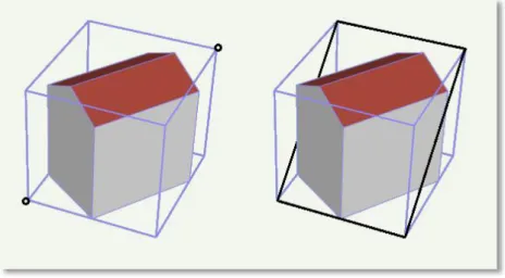
Combined geometries can be aggregates, complexes or composites of primitives (see illustration in figure 1). In an Aggregate, the spatial relationship between components is not restricted. They may be disjoint, overlapping, touching, or disconnected. GML3 provides a special aggregate for each dimension, a MultiPoint, a MultiCurve, a MultiSurface or a MultiSolid. In contrast to aggregates, a Complex is topologically structured: its parts must be disjoint, must not overlap and are allowed to touch, at most, at their boundaries or share parts of their boundaries. A Composite is a special complex provided by GML3. It can only contain elements of the same dimension. Its elements must be disjoint as well, but they must be topologically connected along their boundaries. A Composite can be a CompositeSolid, a CompositeSurface, or CompositeCurve.
MultiSurface GeometricComplex CompositeSurface
Figure 1: Different types of aggregated geometries [Gröger et al., 2012]
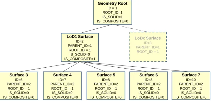
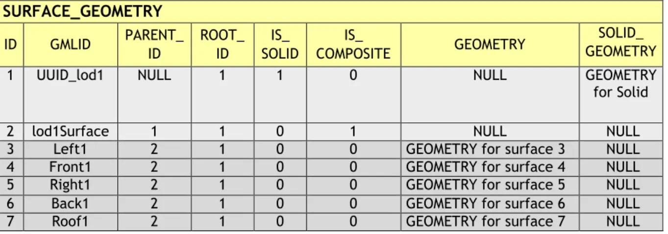
The modelling of two-dimensional and three-dimensional geometry types is handled in a simplified way. All surface-based geometries are stored as polygons, which are aggregated to MultiSurfaces, CompositeSurfaces, TriangulatedSurfaces, Solids, MultiSolids, as well as CompositeSolids accordingly. This simplification substitutes the more complex representation used for those GML geometry classes in grey blocks in Figure 2. Mapping the UML diagram to the relational schema now requires only one table (SURFACE_GEOMETRY), which is explained in chapter 2.3.3.3.
Figure 2: Geometrical-topographical model.
For simplification the geometry classes in the grey block are substituted by the construct in the orange block
In order to implement topology, CityGML uses the XML concept of XLinks provided by GML. Each geometry object that should be shared by different geometric aggregates or different thematic features is assigned a unique identifier, which may be referenced by a GML geometry property using a href attribute. The XLink topology is simple and flexible and nearly as powerful as the explicit GML3 topology model. However, a disadvantage of the XLink topology is that navigation between topologically connected objects can only be performed in one direction (from an aggregate to its components), not (immediately) bidirectional, as it is the case for GML’s built-in topology.
Implicit Geometry
The concept of implicit geometries is an enhancement of the GML3 geometry model.
An implicit geometry is a geometric object, where the shape is stored only once as a prototypical geometry, for example a tree or other vegetation objects, a traffic light or traffic sign. This prototypic geometry object is re-used or referenced many times, wherever the
corresponding feature occurs in the 3D city model. Each occurrence is represented by a link to the prototypic shape geometry (in a local Cartesian coordinate system), by a transformation matrix that is multiplied with each 3D coordinate of the prototype, and by an anchor point denoting the base point of the object in the world coordinate reference system. The concept of implicit geometries is similar to the well-known concept of primitive instancing used for the representation of scene graphs in the field of computer graphics [Foley et al. 1995].
Figure 3: Implicit Geometry model
Implicit geometries may be applied to features from different thematic fields in order to geometrically represent the features within a specific level of detail (LOD). Thus, each CityGML thematic extension module (like Building, Bridge, and Tunnel etc.) may define spatial properties providing implicit geometries for its thematic classes.
The shape of an implicit geometry can be represented in an external file with a proprietary format, e.g. a VRML file, a DXF file, or a 3D Studio MAX file. The reference to the implicit geometry can be specified by an URI pointing to a local or remote file, or even to an appropriate web service. Alternatively, a GML3 geometry object can define the shape. This has the advantage that it can be stored or exchanged inline within the CityGML dataset.
Typically, the shape of the geometry is defined in a local coordinate system where the origin lies within or near to the object’s extent. If the shape is referenced by an URI, also the MIME type of the denoted object has to be specified (e.g. “model/vrml” for VRML models or
“model/x3d+xml” for X3D models).
The implicit representation of 3D object geometry has some advantages compared to the explicit modelling, which represents the objects using absolute world coordinates. It is more space-efficient, and thus more extensive scenes can be stored or handled by a system. The visualization is accelerated since 3D graphics hardware supports the scene graph concept.
Furthermore, the usage of different shape versions of objects is facilitated, e.g. different seasons, since only the library objects have to be exchanged.
Appearance Model
Information about a surface’s appearance, i.e. observable properties of the surface, is considered an integral part of virtual 3D city models in addition to semantics and geometry.
Appearance relates to any surface-based theme, e.g. infrared radiation or noise pollution, not just visual properties and can be represented by – among others – textures and georeferenced textures. Appearances are supported for an arbitrary number of themes per city model. Each LoD of a feature can have individual appearances. Each city object or city model respectively may store its own appearance data. Therefore, the base CityGML classes _CityObject and CityModel contain a relation appearance and appearanceMember respectively.
Figure 4: Appearance model
Themes are represented by an identifier only. The appearance of a city model for a given theme is defined by a set of objects of class Appearance, referencing this theme through the attribute theme. All appearance objects belonging to the same theme compose a virtual group.
An Appearance object collects surface data relevant for a specific theme through the relation surfaceDataMember. Surface data is represented by objects of the abstract class _SurfaceData. Its only attribute is the Boolean flag isFront, which determines the side (front and back face of the surface) a surface data object applies to.
A constant surface property is modelled as material. A surface property, which depends on the location within the surface, is modelled as texture. Each surface object can have both a material and a texture per theme and side. This allows for providing both a constant approximation and a complex measurement of a surface’s property simultaneously. If a surface object is to receive multiple textures or materials, each texture or material requires a separate theme. The mixing of themes or their usage is not explicitly defined but left to the application.
![Figure 6: Example of buildings consisting of one and two building parts [Gröger et al., 2008]](https://thumb-eu.123doks.com/thumbv2/1library_info/4477438.1590517/36.892.182.701.891.1115/figure-example-buildings-consisting-building-parts-gröger-et.webp)