M130, Mindelo – Recife
August 28th to October 3rd, 2016 1st Weekly Report, August 28th, 2016
METEOR cruise M130 started in Mindelo, Cape Verde, today. The research cruise is part of the collaborative research center (SFB) 754 „Climate - biogeochemistry interactions in the tropical ocean“ funded by the Deutsche Forschungsgemeinschaft and the BMBF cooperative project “Regional Atlantic circulation and global change"
(RACE). A regional focus of the SFB 754 related physical-biogeochemical investigations is the oxygen minimum zone (OMZ) in the eastern tropical north Atlantic. The cruise related activities aims at advancing quantification of the oxygen budget in the oxygen minimum zone. Besides oxygen supply by mean advection, diapycnal and lateral eddy fluxes, we focus on advancing oxygen consumption estimates. Further objectives are investigating the role of zooplankton and its vertical migration for fluxes of particulate and dissolved matter to the OMZ as well as advancing quantitative understanding of nitrogen fixation in the near surface layers of the tropical Atlantic. In the second part of the cruise in the region of the western tropical south Atlantic, investigations will focus on the variability of transport and water mass properties of the western boundary current off Brazil.
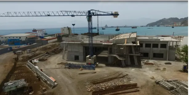
Before boarding METEOR yesterday a few of us were given the opportunity to visit the construction site of the Ocean Science Centre Mindelo (OSCM, Fig. 1). The OSCM is a joint effort of the Cape Verdean Instituto Nacional de Desenvolvimento das Pescas (INDP) in Mindelo and GEOMAR Helmholtz-Center for Ocean Research Kiel. The building will serve as a scientific and logistic platform for marine and atmospheric research off western Africa. We were very impressed by extend and the development of the building.
Fig. 1: Construction site of the Ocean Science Centre Mindelo (Photo: Björn Fiedler)
The measurement program should have started today shortly after leaving port with the recovery of the CVOO (Cape Verde Ocean Observatory) mooring. We have spent the last 2 days setting set-up our equipment in the laboratories and preparing our instruments. However, due to a late arrival of one of our containers carrying dangerous good, we were forced to stay in the harbor for an additional day. Despite sending the delayed container along with 6 other containers ahead of schedule, it missed three departures for not fully resolved reasons but made the final freighter for a timely arrival in Mindelo. Due to engine problems during the passage, the arrival of that freighter was delayed by nearly two days and finally entered the harbor of Mindelo today at 16:00 local time. After custom procedures, the container is scheduled to be uploaded to METEOR tomorrow at 8:00.
We are anxious to get underway to the CVOO station after loading the remaining container at 10:00 tomorrow morning.
Best regards from the tropical north Atlantic
Marcus Dengler and the participants of the M130 cruise
M130, Mindelo – Recife
August 28th to October 3rd, 2016 2nd Weekly Report, September 4th, 2016
After successfully completing mooring work to the North of the Cape Verde Island São Vicente and recovering a drifting surface buoy, our activities are now focused on investigating different processes within the oxygen minimum zone of the tropical northeastern Atlantic.
Oxygen minimum zones are usually found in regions of sluggish circulation. Oxygen- rich waters subducted from the mixed layer into thermocline in the subtropics barely reaches these “shadows zones” within the mean circulation pathways. Historical data has shown that since the 1970s, oxygen content in the oxygen minimum zone of the tropical northeastern Atlantic, like in most other oxygen minimum zones, has decreased. The reason for this decrease is not fully understood, in particular because state of the art climate biogeochemistry models do not correctly simulate oxygen minimum zones.
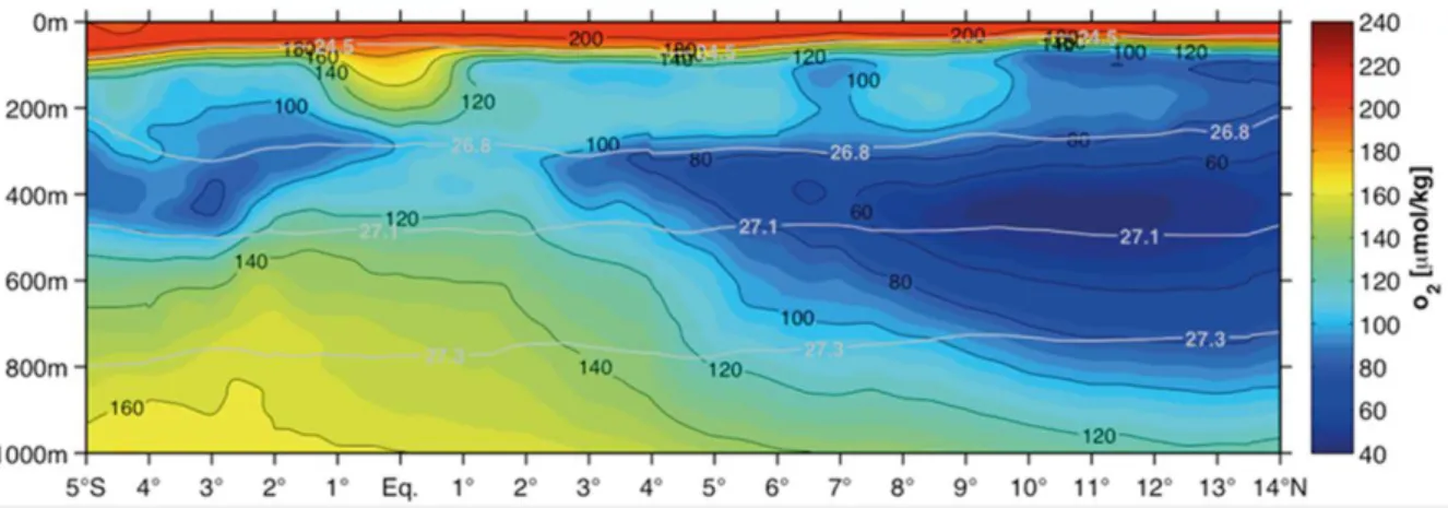
Within the second phase of SFB 754, an oxygen budget for the northeastern tropical Atlantic based on data collected within SFB 754 was developed for the first time. It showed that more than 60% of the oxygen consumption due to respiration of sinking organic material in the deep oxygen minimum zones (300-700m depth, Fig. 1) is balanced by the divergence of meridional eddy fluxes. A further 20% of this consumption is balanced by diapycnal mixing from layers above and below the oxygen minimum zones. Parts of the remaining 20% are carried to oxygen minimum zone by the zonal circulation, while a smaller percentage contributes to the ongoing decrease in oxygen content. A major goal of our activities in the oxygen minimum zone is to improve understanding of the processes related to the oxygen balance and to determine more accurately the magnitude of the individual terms of the balance.
A second objective of the measurement program is to investigate interannual to decadal variability of oxygen and hydrography in the oxygen minimum zone. The data sets collected during SFB 754 field campaigns to the tropical northeast Atlantic
Fig. 1: Average oxygen concentrations along the meridional transect at 23°W.
in the last 10 years show that recent trends in oxygen concentrations strongly depend on the depth interval and time span considered. In the upper region (150m- 300m) oxygen content has strongly reduced during the last 10 years. On the other hand, oxygen content in the deeper water column (350m-700m) of the oxygen minimum zones has slightly increased. Extending the available oxygen and hydrographic data set will thus contribute to elucidate the processes responsible for interannual to decadal variability of oxygen and hydrography in the eastern tropical Atlantic.
The measurement program consists of CTD/O2 (conductivity-temperature-depth and oxygen concentration profile) measurements along the 23°W section as well as the recovery and redeployment of two moorings measuring long-term time series of oxygen concentrations and hydrography. Additionally, tracer (CFC-12, SF6) concentrations measurements are being performed at high-spatial resolution. This data will be used together with climatological data to review existing methods to determine water mass ages in order to achieve a consistent estimate of oxygen consumption in the oxygen minimum zone.
CVOO Time series station
Shortly after leaving port last Monday, we started the recovery of the CVOO (Cape Verde Ocean Observatory) mooring to the north of the island São Vicente, Cape Verde.
The CVOO was deployed in June 2006 for the first time. Since then, the mooring has been serviced at a 1.5-year interval. It serves as an interdisciplinary observatory which hosts a large number of instruments including temperature, salinity, oxygen, carbon dioxide and chlorophyll sensors as well as current meters that are distributed throughout the whole water column. During this deployment phase, Zooplankton settlement samplers were included for the first time. The data from these samplers will be interpreted in reference with other plankton samplers currently moored close to the Canary Islands and the Porcupine bank.
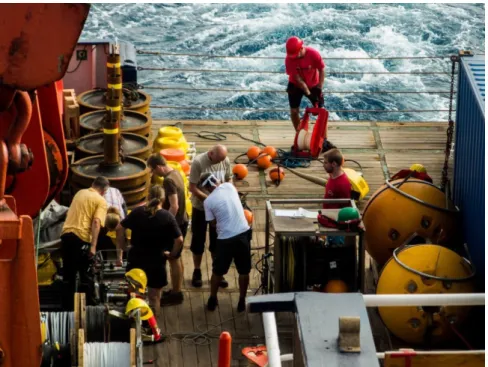
Fig. 2: Preparations for the deployment of the CVOO mooring (photo Jan F. Schubert)
Recovery of a drifting surface buoy
A few days before our cruise started we were contacted by Dutch colleagues from Royal Netherlands Institute for Sea Research. They informed us of a moored surface buoy off Mauritania that had come loose and was drifting towards the Cape Verde Islands. The buoy is part of a mooring array for determining the input of dust to the northern tropical Atlantic Ocean. The surface buoy was located about 150 nm northeast of the CVOO mooring position when we started the mooring recovery last Monday. In between recovery and redeployment, we used the preparation time to recover the surface buoy that was subsequently placed on the bow of METEOR and secured. Thanks to the professionalism of METEOR’s crew, the recovery of the buoy was completed within a few hours, minimizing the loss of ship time for our cruise. We will hand over the buoy to our Dutch colleagues upon arrival in Recife, Brazil.
On Monday afternoon, our work along the 23°W section will be suspended in order to survey a tracer in the eastern tropical Atlantic that was deliberately released in the center of the oxygen minimum zone 3 years ago. On Wednesday, we will recover and redeploy a mooring at 11°S 21°W.
Best regards from the tropical north Atlantic, Marcus Dengler and the participants of M130
Fig. 3: Recovery of the drifting surface buoy (photo: Simona Dittrich-Knüppel)
M130, Mindelo – Recife
August 28th to October 3rd, 2016 3nd Weekly Report, September 11th, 2016
Today, our activities have focused on recovering and redeploying a mooring at 5°N, 23°W. A second mooring at 11°N, 21°W was recovered and redeployed on Thursday.
Both moorings are equipped with instrumentation recording time series of currents, hydrography and oxygen concentration. Other works accomplished this week include the survey of a tracer in the eastern tropical Atlantic that was released in the center of the oxygen minimum zone more than 3 years ago and comprehensive measurements along the 23°W section.
Time series of dissolved oxygen
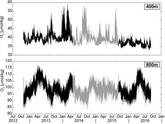
Both moorings serviced this week are an integral component of the SFB 754 related observing system in the eastern tropical north Atlantic. Since 2009, time series of oxygen concentration, velocity and hydrography have been obtained from the mooring at the southern rim of the oxygen minimum zone at 5°N, 23°W. The mooring from the center of the oxygen minimum zone has delivered the same time series data since 2012 (Fig. 1). The time series that are collected in the depth interval between 100m and 800m are used to quantify oxygen, hydrographic and current variability within the oxygen minimum zone and associated lateral oxygen fluxes with a particular focus on the role of mesoscale processes.
Fig. 1: Time series of oxygen concentration from the centre of the oxygen minimum zone (11°N, 21°W) from 400m (upper) und 800m (lower) depth. Black lines indicate the first (left) and the just recovered third (right) mooring period. The grey line indicates oxygen concentrations measured during the second deployment period. (Plot by Johannes Hahn)
The 4-year time series of oxygen content from the center of the oxygen minimum zone from 400m depth shows the oxygen decrease over the past four years that is not apparent in the time series from 800m (Fig. 1). Instead, the data from 800m show pronounced seasonal variability of oxygen concentration during most years. The physical processes responsible for the seasonal variability are currently subject of investigation.
OSTRE tracer survey
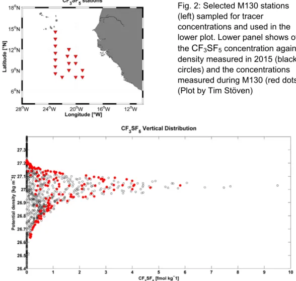
To quantify the strength of lateral and vertical mixing processes within the oxygen minimum zone, an artificial tracer was released in the center of the oxygen minimum zone at 11°N, 21°S in December 2012. During this Oxygen Supply Tracer Release Experiment (OSTRE) the tracer was injected at a density of 27.03 kg m-3, corresponding to a depth of about 400m. The lateral and vertical distribution of the tracer patch was subsequently surveyed during the previous expeditions M97, M105 and M116 by sampling high-resolution station grids.
During our cruise, the tracer was sampled on a reduced station grid. The measurements showed that the lateral spreading of the tracer has now extended from the Cape Verde islands (15°N) to as far as 5°N. Comparing the sampled vertical distribution to the vertical distribution from earlier cruises, the tracer had again spread to different lower as well as higher density classes (Fig. 2, lower panel). The data will be used to improve the estimate of vertical mixing from the tracer diffusion.
Fig. 2: Selected M130 stations (left) sampled for tracer
concentrations and used in the lower plot. Lower panel shows of the CF3SF5 concentration against density measured in 2015 (black circles) and the concentrations measured during M130 (red dots).
(Plot by Tim Stöven)
Impact of zooplankton on biogeochemical cycles
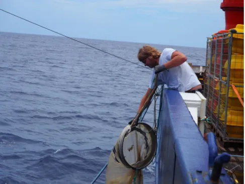
One major focus of this cruise is investigating the role of zooplankton – millimeter sized animals that drift in the ocean – for the biogeochemical cycles of the oxygen minimum zone. Amongst other instruments, we use an underwater vision profiler mounted to the CTD rosette that can be lowered to 6000m depth. During the decent of the profiler, high-definition pictures are taken at a sampling rate of 10 Hz which are then used to quantify the abundance of zooplankton. Recent results using this method have shown that single-celled zooplankton – so called Rhizarier – are much more abundant than previously assumed. These organisms are very fragile. Thus, plankton nets hauls cannot be used to quantitatively assess the biomass of these animals.
Information about other characteristics of the Rhizarier such as respiration rates, are very scares. Thus, we use drift nets to catch to avoid damaging them as far as possible. After some difficulties at the beginning, strategies have now been found to catch sufficient organisms for the investigation of respiration, size and biomass. In combination with the pictures from the UVP, our investigations will advance understanding of the role of these organisms in the ocean.
During the coming week we will complete the measurement program along the 23°W section. On Thursday, we will service our mooring on the equator.
Best regards from the tropical north Atlantic, Marcus Dengler and the participants of M130
Fig. 3: Jannik Faustmann retrieving a drift net (Photo:
Rainer Kiko)
M130, Mindelo – Recife
August 28th to October 3rd, 2016 4th Weekly Report, September 18th, 2016
During the 4th week our activities have focused on the equatorial region of the 23°W section and the recovery and deployment of a mooring on the equator. The physical and biogeochemical measurement program was successfully continued and we were particularly happy that all our instruments attached to the equatorial mooring returned full data sets. This includes a vertically-continuous velocity time series from the surface to a depth of 3500m.
Equatorial currents in the Atlantic
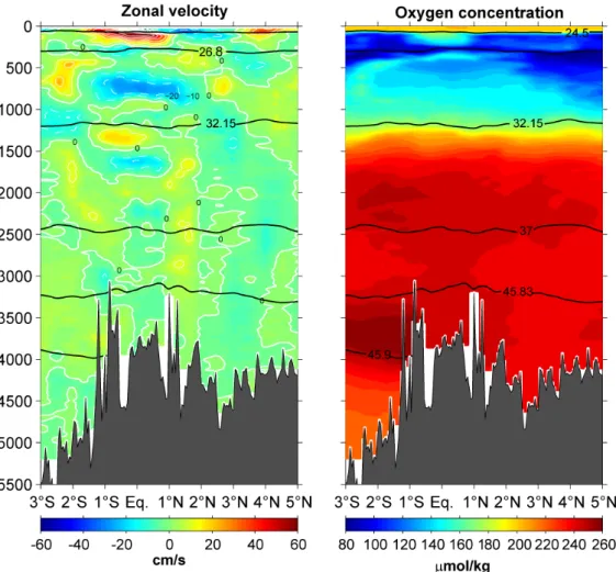
The equatorial circulation has been a research focus at GEOMAR for a long time.
The variability of the energetic zonal currents is linked to climate variability in the Atlantic sector. An improved understanding of the current variability will lead to improved medium-range climate predictions, particularly for western Africa and Brazil. Furthermore, the equatorial current system is important for the oxygen supply to the oxygen minimum zones. The eastward currents are linked to elevated oxygen
Abb. 1: Zonal velocity in cm/s (left panel) and concentration of dissolved oxygen in mol/kg (right panel) between 3°S and 5°N along 23°W. (Plot: Marcus Dengler)
Fig. 2: Distribution of nutrients and Trichodesmium along the 23°W section. (Plot: Rainer Kiko, Matt Patey)
concentrations and thus transport oxygen from the western boundary to the central and eastern equatorial regions (Fig. 1). Parts of this advective oxygen flux is then supplied to the oxygen minimum zones to the north and the south of the equator by lateral eddy mixing.
An important component of the equatorial circulation, both for climate variability and the oxygen budget of the tropical Atlantic, are the “equatorial Deep Jets“. These zonal currents, which have a period of 4.5 years, have short vertical scales and are pronounced within 1° of the equator between 300 and 2500m depth (Fig. 1). They can be rationalized as a free oscillation of the equatorial Atlantic. The Deep Jets are generated in the deep ocean but also move water at the sea surface which in turn forces interannual variability of temperature, precipitation and wind in western Africa and Brazil.
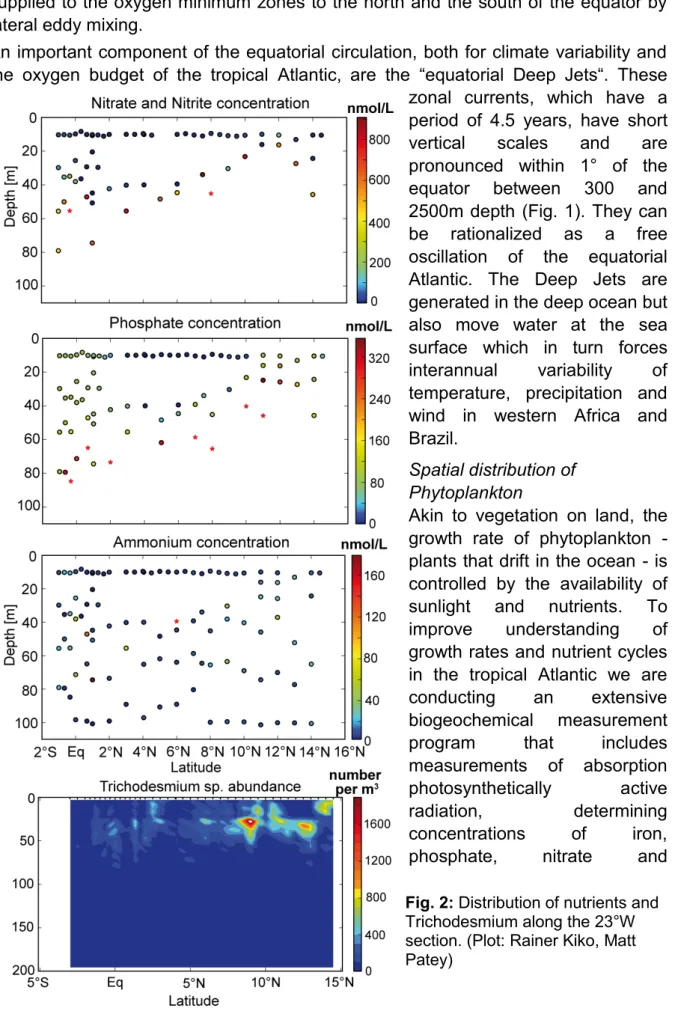
Spatial distribution of Phytoplankton
Akin to vegetation on land, the growth rate of phytoplankton - plants that drift in the ocean - is controlled by the availability of sunlight and nutrients. To improve understanding of growth rates and nutrient cycles in the tropical Atlantic we are conducting an extensive biogeochemical measurement program that includes measurements of absorption photosynthetically active radiation, determining concentrations of iron, phosphate, nitrate and
ammonium (Fig. 2) and sampling the distribution of Phytoplankton and its activity in the upper water column. The concentration of nutrients depends on several different factors. Iron is supplied predominately by the atmosphere, nitrate is fluxed upward from the deeper ocean predominately by mixing events and ammonium is predominately supplied from degradation processes of organic material.
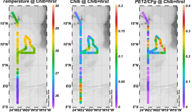
As the cells of Phytonplankton strongly utilize nutrients in variable proportions, nutrient concentrations in the near-surface layers are small but vary along the 23°W section (Fig. 2). In the region between 10°N and 14˚N and at the equator between 2˚N and 2˚S, Phosphate concentrations in the near-surface layers are elevated but nitrate and ammonium concentrations are very low. These regions are characterized as upwelling regions, in which nutrient availability is relatively high and elevated growth rates of Phytoplankton are recorded. In these region, nitrate and ammonium are taken up in the deeper layers leaving a niche for nitrogen fixing organisms in the near-surface layer. An example of such an organism is the cyanobacteria Trichodesmium sp., which we found to be particularly abundant in the region between 10°N and 14˚N (Fig. 2, lower panel) using the Underwater Vision Profiler (UVP).
Similar to this system, we use an Aquatic Laser Fluoroscence Analyzer (ALFA) to determine the different phytoplankton species in the upper ocean. The ALFA distinguishes between Chlorophyll a and different Phycobiliprotein pigments from cyanobacteria.
First results show that the cooler surface waters north of 15°N host less phytoplankton and cyanobacteria than the region between 10°N and 14°N (Fig. 3).
Cyanobacteria are particularly elevated in the region of the warmer surface waters in the Intertropical Convergence Zone. The upwelling at the equator is dominated by Chlorophyll a (Fig. 3).
Apart from the ship-based measurements processed on board described above, sampling of dissolve iron concentrations in the surface waters and experiments to
Fig. 3: Sea surface temperature (left panel), chlorophyll a concentration (center panel) and Phybiliprotein concentration (right panel). (Plot: Ajit Subramaniam)
quantify nitrogen fixation and primary productivity are being conducted on board. The data, however, will only be available following extensive laboratory analysis at home.
We will have completed our measurement program along 23°W by Monday at noon.
After a 2.5 day transit, we are due to begin our measurement program in the western boundary regime of the coast of Brazil on Wednesday afternoon.
Best regards from the tropical south Atlantic, Marcus Dengler and the participants of M130
00LQGHOR±5HFLIH
$XJXVWWKWR2FWREHUUG WK:HHNO\5HSRUW6HSWHPEHUWK
$IWHU D WZR GD\ WUDQVLW HQGLQJ RQ :HGQHVGD\ ZH KDYH VWDUWHG RXU REVHUYDWLRQDO SURJUDPLQWKHZHVWHUQERXQGDU\UHJLRQRII%UD]LODW62XUDFWLYLWLHVIRFXVVLQJ RQ WKH GHWHUPLQLQJ WKH VWUHQJWK DQG YDULDELOLW\ RI WKH ZHVWHUQ ERXQGDU\ FLUFXODWLRQ ZHUHYHU\VXFFHVVIXO:HZHUHDEOHWRUHFRYHUDQGUHGHSOR\DOOIRXUPRRULQJV)LJ DQG ZHUH YHU\ KDSS\ DERXW WKH UHWXUQHG GDWD VHWV RI WKH LQVWUXPHQWV PRXQWHG WR WKH PRRULQJV UHFRUGHG IXOO GDWD VHWV DQG LQ SDUWLFXODU DOO FXUUHQW PHWHU KDGIXQFWLRQHGFRUUHFWO\
2XU LQYHVWLJDWLRQV RII %UD]LO DUH SDUW RI WKH %0%) FRRSHUDWLYH SURMHFW ³5HJLRQDO
$WODQWLFFLUFXODWLRQDQGJOREDOFKDQJH5$&(7KHGDWDIURPWKHPRRULQJVDVZHOO DVWKHVKLSERDUGPHDVXUHPHQWVDUHXVHGWRGHWHUPLQHWKHWUDQVSRUWYDULDELOLW\RIWKH 1RUWK%UD]LO8QGHUFXUUHQWLQWKHXSSHUPDQGWKH6RXWK$WODQWLF'HHS:HVWHUQ
%RXQGDU\&XUUHQWVLWXDWHGEHWZHHQPDQGPGHSWK)LJ%RWKFXUUHQWV DUHHVVHQWLDOFRPSRQHQWVRIWKHPHULGLRQDORYHUWXUQLQJFLUFXODWLRQ7KH1RUWK%UD]LO 8QGHUFXUUHQW WUDQVSRUWV ZDUP ZDWHU RULJLQDWLQJ IURP WKH 6RXWKHUQ +HPLVSKHUH VXEWURSLFV DQG WKH ,QGLDQ 2FHDQ QRUWKZDUG DFURVV WKH HTXDWRU 9LD WKH *XOIVWUHDP WKHVH ZDWHUV HQWHU WKH 1RUWK $WODQWLF ZKHUH WKH\ VLQN DQG IRUP WKH 1RUWK $WODQWLF 'HHS:DWHU)LQDOO\WKH'HHS:HVWHUQ%RXQGDU\&XUUHQWFDUULHVWKH1RUWK$WODQWLF 'HHS:DWHUVRXWKZDUGDFURVVWKHHTXDWRUZKHUHLWUHDFKHVWKHFRQWLQHQWDOVORSHRII
%UD]LO
)LJ$YHUDJHDORQJVKRUH YHORFLW\RII%UD]LODW6 5HGFRQWRXUVLQGLFDWH QRUWKZDUGYHORFLWLHVLQWKH 1RUWK%UD]LO8QGHUFXUUHQW
%OXHFRQWRXUVVKRZ VRXWKZDUGYHORFLWLHV DVVRFLDWHGZLWKWKHGHHS ZHVWHUQERXQGDU\FXUUHQW 0RRULQJSRVLWLRQV.WR.
DQGGLVWULEXWLRQRIWKH LQVWUXPHQWVDORQJWKH PRRULQJVDUHDGGLWLRQDOO\
VKRZQ3ORW5HEHFFD +XPPHOV
Our mooring array at the western boundary that is in operation since July 2013, and the shipboard observations thus capture an essential part of the basin-scale meridional overturning circulation. Our aim is to determine inter annual to decadal variability of the currents as well as the variability of the water masses exchanged between the two Hemispheres.
Transient tracers along 23°W
In addition to physical measurements, chemical measurements of transient tracers performed during the cruise help us to advance understanding of the circulation and the pathways of water masses in the ocean. The transient tracer field work consists of three major working areas. Apart from the tracer release survey that was reported in the 3rd weekly report, the concentrations of chlorofluorocarbon (CFC-12) and sulphur hexafluoride (SF6) in the water column are measured (Fig. 2) using purge and trap gas chromatography. Both of these so called “transient tracers” enter the ocean via gas-exchange at the air-sea interface only. The tracers are then transported into ocean interior via ventilation processes such as deep water formation in the North Atlantic or subduction processes in the subtropical gyres. The
Abb. 2: Partial pressure distribution of CFC-12 (upper left panel) and SF6 (lower left panel) in 10-12 parts (ppt - parts per trillion) along 23°W. The right panel shows the distribution of available transient trace gas (CFC-12) data in global inventories. Colour code represents pressure of the isopycnal surface σθ=27.0 m3 kg-1. Blue regions represent water mass formation regions. (Plots: Tim Stöven).
atmospheric concentration histories of such tracers provide time information which can be used to determine different types of “age” of a water parcel. CFC-12 and SF6
have distinct differences in their atmospheric history. CFC-12 has been released into the atmosphere since the late 1920s, whereas SF6 is produced on an industrial scale since the beginning of the 1950s. Therefore, the CFC-12 tracer can already be found in less ventilated water masses contrary to the SF6 tracer, which is mostly absent in such ocean regions (Fig. 2).
When combined with circulation models, the time information of the transient tracers allow calculation of additional parameters, such as the anthropogenic carbon content in the water column and oxygen utilization rates. The latter is of particular interest for the understanding of oxygen minimum zones and their development in the future. On the other hand, our measurements contribute to the global data set of transient tracers in the Atlantic sector of the world ocean (Fig. 2). Based on this data collection, it is possible to track water parcels from their formation regions along their pathways into the oxygen minimum zone of the eastern north Atlantic providing additional information about the oxygen budget as well as the oxygen utilization rates.
We will have completed our ship-board measurements and mooring activities along 11°S by Monday evening. After a transit of 1.2 days, we will continue our measurement program in the western boundary region at 5°S.
Best regards from the tropical south Atlantic, Marcus Dengler and the participants of M130
M130, Mindelo – Recife
August 28th to October 3rd, 2016 6th Weekly Report, October 2nd, 2016
Since completing the station work Saturday afternoon, we are steaming toward Recife where we will enter the port Monday morning. The measurement program along the 5°S section was successfully completed. As we finished the mooring work at 11°S in less time than expected, the extra time left was used to extend the 5°S section farther offshore by three CTD stations. In combination with the mooring and section data at 11°S, a new data set is now available describing the variability and change of the western boundary circulation off Brazil that will contribute to understanding its impact on climate variability in the North Atlantic sector.
Abb. 1: Gruppenbild der wissenschaftlichen Teilnehmer von M130.
In a concluding seminar held today the results of the preliminary data processing was discussed. Amongst other things, it reminded us of the diversity of the physical, chemical and biological parameters collected during the measurement program.
During the talks, it also became obvious that often distributions of the interdisciplinary parameters are connected to each other. For example, a subsurface anticyclonic eddy with a low oxygen core that we sampled at 13°N on 23°W was connected to elevated abundance of cyanobacteria at the sea surface and an elevated abundance of particles in center of the eddy. A large number of particularly the biological
parameters will be determined in the laboratories at home. The interdisciplinary discussions will then be continued.
A successful but also very work-intensive research cruise has nearly come to completion. We are grateful to Capitan Schubert and his crew for the excellent collaboration and the pleasant working atmosphere during the cruise. The crew of FS METEOR greatly contributed to the success of the cruise. Likewise, I am grateful to the dedication and commitment of the scientists and technical staff who equally contributed to the success of this cruise.
Best regards from the tropical south Atlantic, Marcus Dengler and the participants of M130