Snow depth on Arctic sea ice derived from airborne radar measurements
Arttu Jutila1, Robert Ricker1, Stefan Hendricks1, John Paden2, Joshua King3, Chris Polashenski4,5, Benjamin A. Lange6, Christine Michel6, and Christian Haas1,7
1Alfred-Wegener-Institut Helmholtz-Zentrum für Polar- und Meeresforschung
2Center for Remote Sensing of Ice Sheets, University of Kansas
3Environment and Climate Change Canada
4US Army Corps of Engineers – Cold Regions Research and Engineering Laboratory
5Thayer School of Engineering at Dartmouth College
6Fisheries and Oceans Canada, Freshwater Institute
7University of Bremen, Institute for Environmental Physics
Photo credit: Stefan Hendricks
Key results
• Part of a unique
instrumentation setup
• Includes areas not surveyed by Operation IceBridge in 2019
Novel dataset of 650 000+
measurements of snow depth on sea ice
in 2017-2019
• RMSE 7.20 cm
• Mean bias 6.35 cm
• Correlation 0.62
• Uncertainty 6.52 cm
Ground validation over a 2-D grid
Novel interface picker software
FYI = first-year ice | MYI = multi-year ice AMB = ambiguous
SnowRadar
AWI IceBird missions NASA OIB
Nominal survey altitude [ft] 200 1600 1600
Nominal survey velocity [kn] 110 160 250
Cross-track footprint1 [m] 2.1 6.0 6.0
Along-track footprint2 [m] 2.0 10.8 13.8
Range resolution3 [cm] 0.94 – 1.14 0.94 – 1.14
Transmit power [mW] 100 1000 1000
2-18 GHz frequency-modulated continuous-wave ultra-wideband microwave radar developed by the Center for Remote Sensing of Ice Sheets (CReSIS) at the University of Kansas
1Cross-track footprint is calculated using a pulse limited footprint over a flat surface.
2Along-track footprint is calculated using the length of the unfocussed SAR aperture.
3Range resolution is calculated considering free space and snow density of 300 kg m-3, respectively.
Photo credit: Stefan Hendricks
Processing - I
cresis-toolbox (MATLAB)
Quicklook
• In the field
Away from aircraft
Processing - I
cresis-toolbox (MATLAB)
Quicklook
• In the field
Coherent noise removal
Away from aircraft
Along track distance (frame = 5 km)
Processing - I
cresis-toolbox (MATLAB)
Quicklook
• In the field
Coherent noise removal
Deconvolution
Away from aircraft
Processing - II
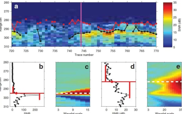
Fig. 3 from Newman et al. (2014), Assessment of radar-derived snow depth over Arctic sea ice, J. Geophys. Res. Oceans
Interface detection using modified Wavelet algorithm (Newman et al., 2014)
• Handles each radar trace independently and finds abrupt changes in signal
• Haar & Ricker wavelets, continuous wavelet transform
• Does not depend on thresholds, transmitted power, or receiver noise
• Precision due to radar system parameters
~1.5 cm
• pySnowRadar Python package will be
made public soon
Processing - II
air-snow interface
potential snow-ice interface refrozen lead?
Away from aircraft
Processing - II
air-snow interface
potential snow-ice interface refrozen lead?
Away from aircraft
Along track distance (frame = 5 km)
Processing - II
air-snow interface
potential snow-ice interface refrozen lead?
Away from aircraft
Poster 82A3292, Hendricks et al. IceBird: a pan-Arctic airborne sea ice observation system
Deployments
First results - validation
First results - distributions
In situ data courtesy of B. Lange & C. Michel Ice type from the daily 10-km EUMETSAT OSI SAF Global Sea Ice Type product
FYI = first-year ice | MYI = multi-year ice FYI = first-year ice | MYI = multi-year ice
AMB = ambiguous
Application example
Acknowledgments
asdadsasd
Limitations & challenges
• Radar and wavelet algorithm sensitivity to snowpack properties
• Low survey altitude
• Prone to turbulence
• Radar footprint size
Outlook
• Sub-banding radar data
• Combining with ALS and other products for QA/QC
• Further validation
• Trail Valley Creek
• MOSAiC
Applications
• Kenn Borek Air Ltd., AWI logistics and technicians, and other airborne campaign partners
• We acknowledge the use of software from CReSIS generated with support from the State of Kansas, NASA Operation IceBridge grant NNX16AH54G, and NSF grant ACI-1443054.
• pySnowRadar builds upon the wavelet algorithm, original work of Thomas Newman et al. at NOAA
• Helmholtz Graduate School for Polar and Marine Research (POLMAR): short-term research grant for a two-month stay at Environment and Climate Change Canada, Climate Research Division
• Travel Award from the 2019 IGS Sea Ice Symposium Student/ECR Travel Award Program
• With concurrent
measurements of snow freeboard and total sea ice thickness: freeboard to thickness conversion
on regional scales