• Keine Ergebnisse gefunden

Journal of Geophysical Research OceansSupporting Information forMesoscale eddies in the Northwestern Pacific Ocean: three-dimensional eddy structures and heat/salt transportsDi Dong

N/A
N/A
Protected

Academic year: 2022

Aktie "Journal of Geophysical Research OceansSupporting Information forMesoscale eddies in the Northwestern Pacific Ocean: three-dimensional eddy structures and heat/salt transportsDi Dong"

Copied!
2
0
0

Wird geladen.... (Jetzt Volltext ansehen)

Volltext

(1)

Confidential manuscript submitted to Journal of Geophysical Research Oceans

Journal of Geophysical Research Oceans Supporting Information for

Mesoscale eddies in the Northwestern Pacific Ocean: three- dimensional eddy structures and heat/salt transports

Di Dong

1,2,3

, Peter Brandt

3,4

, Ping Chang

5,6,7

, Florian Schütte

3

, Xiaofeng Yang

8

, Jinhui Yan

1

and Jisheng Zeng

1

1 South China Sea Institute of Planning and Environmental Research, SOA, Guangzhou, PR China.

2 University of Chinese Academy of Sciences, Beijing, PR China.

3 GEOMAR Helmholtz Centre for Ocean Research Kiel, Kiel, Germany.

4 Christian-Albrechts-Universität zu Kiel, Kiel, Germany.

5 Department of Oceanography, Texas A&M University, College Station, TX. USA.

6 Physical Oceanography Laboratory/CIMSST, Ocean University of China and Qingdao National Laboratory for Marine Science and Technology, Qingdao, China.

7 Department of Atmospheric Sciences, Texas A&M University, College Station, TX. USA.

8 State Key Laboratory of Remote Sensing Science, Institute of Remote Sensing and Digital Earth of Chinese Academy of Sciences, Beijing, PR China.
Corresponding author: Di Dong (dongdide90@126.com )

Contents of this file Figures S1

Introduction

This document contains supplementary Figures which support statements

in the main text.

(2)

Confidential manuscript submitted to Journal of Geophysical Research Oceans

(3)

Confidential manuscript submitted to Journal of Geophysical Research Oceans

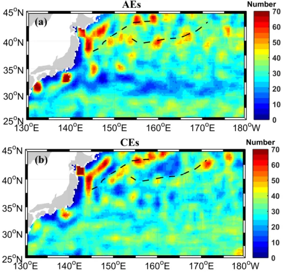
Figure S1. Distribution of the number of (a) AEs and (b) CEs detected in 0.25

o

x0.25

o

bins during the analysis period of 8035 days based on the CH17 dataset. The SAF and

the SAB are shown by dashed lines. A 1.25° x 1.25° running mean filter is used to

reduce data noises. Values larger than 70 are shown with the same color as that

assigned to a value of 70.

Abbildung

Figure S1. Distribution of the number of (a) AEs and (b) CEs detected in 0.25 o x0.25 o bins during the analysis period of 8035 days based on the CH17 dataset

Referenzen

ÄHNLICHE DOKUMENTE

& R Hartogh 1999: Water vapor of the polar middle atmosphere: Annual Variation and summer mesospheric conditions as observed by ground based microwave spectroscopy.. 2000: On the

In typical waters of open Baltic Sea area remote sensing instruments with sufficient spectral resolution (10 nm or better) and high radiometric sensitivity can be used for

Our comparison between satellite and in situ Z eu for data south of 60°S did not show signi fi cant differences between the approaches for SeaWiFS and slightly better esti- mates of Z

A detailed description of the achievable accuracies can be found in Bamler and Eineder (2005). The colors in Fig. 11b indicate the magnitude of the motion that occurred in the

The land surface temperature (LST) is accessible on the pan-arctic scale through a number of remote sensing platforms, such as the “Moderate Resolution Imaging Spectrometer”

the differences in methane emission at different study sites are obvious, and the measured methane emissions from the various sub- classes of the land cover class WT in the Lena

The result of the Landsat ETM+ classi fi cation at the Turakh study site in the western Lena Delta consists of 15 land-cover classes, which differ in vegetation cover,

The Project has recently (1994–1998) carried out a number of activities (applications of remote sensing to changes of forest lands, forest monitoring in Europe with remote