Proceedings of the International Ocean Discovery Program Volume 376 publications.iodp.org
https://doi.org/10.14379/iodp.proc.376.101.2019
Expedition 376 summary
1C.E.J. de Ronde, S.E. Humphris, T.W. Höfig, P.A. Brandl, L. Cai, Y. Cai, F. Caratori Tontini, J.R. Deans, A. Farough, J.W. Jamieson, K.P. Kolandaivelu, A. Kutovaya, J.M. Labonté, A.J. Martin, C. Massiot, J.M. McDermott, I.M. McIntosh, T. Nozaki, V.H. Pellizari, A.G. Reyes, S. Roberts, O. Rouxel, L.E.M. Schlicht, J.H. Seo, S.M. Straub, K. Strehlow, K. Takai, D. Tanner, F.J. Tepley III, and C. Zhang2
Keywords: International Ocean Discovery Program, IODP, JOIDES Resolution, Expedition 376, Brothers Arc Flux, Brothers volcano, Site U1527, Site U1528, Site U1529, Site U1530, Site U1531, Kermadec arc, submarine arc volcano, hydrothermal systems, volcaniclastics, dacite lava, hydrothermal alteration, borehole fluids, hypersaline brine, fluid inclusions, acidic fluids, alteration mineral assemblages, Upper Cone, Lower Cone, NW Caldera
1de Ronde, C.E.J., Humphris, S.E., Höfig, T.W., Brandl, P.A., Cai, L., Cai, Y., Caratori Tontini, F., Deans, J.R., Farough, A., Jamieson, J.W., Kolandaivelu, K.P., Kutovaya, A., Labonté, J.M., Martin, A.J., Massiot, C., McDermott, J.M., McIntosh, I.M., Nozaki, T., Pellizari, V.H., Reyes, A.G., Roberts, S., Rouxel, O., Schlicht, L.E.M., Seo, J.H., Straub, S.M., Strehlow, K., Takai, K., Tanner, D., Tepley, F.J., III, and Zhang, C., 2019. Expedition 376 summary. In de Ronde, C.E.J., Humphris, S.E., Höfig, T.W., and the Expedition 376 Scientists, Brothers Arc Flux. Proceedings of the International Ocean Discovery Program, 376: College Station, TX (International Ocean Discovery Program). https://doi.org/10.14379/iodp.proc.376.101.2019
2Expedition 376 Scientists’ affiliations.
Contents
1 Abstract 2 Introduction 2 Geological setting 6 Scientific objectives 6 Site summaries
23 Preliminary scientific assessment 25 References
Abstract
Volcanic arcs are the surface expression of magmatic systems that result from subduction of mostly oceanic lithosphere at conver- gent plate boundaries. Arcs with a submarine component include intraoceanic arcs and island arcs that span almost 22,000 km on Earth’s surface, and the vast majority of them are located in the Pa- cific region. Hydrothermal systems hosted by submarine arc volca- noes commonly contain a large component of magmatic fluid. This magmatic-hydrothermal signature, coupled with the shallow water depths of arc volcanoes and their high volatile contents, strongly in- fluences the chemistry of the fluids and resulting mineralization and likely has important consequences for the biota associated with these systems. The high metal content and very acidic fluids in these hydrothermal systems are thought to be important analogs to numerous porphyry copper and epithermal gold deposits mined to- day on land.
During International Ocean Discovery Program (IODP) Expedi- tion 376 (5 May–5 July 2018), a series of five sites was drilled on Brothers volcano in the Kermadec arc. The expedition was designed to provide the missing link (i.e., the third dimension) in our under- standing of hydrothermal activity and mineral deposit formation at submarine arc volcanoes and the relationship between the dis- charge of magmatic fluids and the deep biosphere. Brothers volcano hosts two active and distinct hydrothermal systems: one is seawater influenced and the other is affected by magmatic fluids (largely gases). In total, 222.4 m of volcaniclastics and lavas were recovered from the five sites drilled, which include Sites U1527 and U1530 in the Northwest (NW) Caldera seawater-influenced hydrothermal field; Sites U1528 and U1531 in the magmatic fluid-influenced hy-
drothermal fields of the Upper and Lower Cones, respectively; and Site U1529, located within an area of low crustal magnetization that marks the West (W) Caldera upflow zone on the caldera floor.
Downhole logging and borehole fluid sampling were completed at two sites, and two tests of a prototype turbine-driven coring system (designed by the Center for Deep Earth Exploration [CDEX] at Japan Agency for Marine-Earth Science and Technology [JAMSTEC]) for drilling and coring hard rocks were conducted.
Core recovered from all five sites consists of dacitic volcaniclas- tics and lava flows with only limited chemical variability relative to the overall range in composition of dacites in the Kermadec arc.
Pervasive alteration with complex and variable mineral assemblages attest to a highly dynamic hydrothermal system. The upper parts of several drill holes at the NW Caldera hydrothermal field are charac- terized by secondary mineral assemblages of goethite + opal + zeo- lites that result from low-temperature (<150°C) reaction of rock with seawater. At depth, NW Caldera Site U1527 exhibits a higher temperature (~250°C) secondary mineral assemblage dominated by chlorite + quartz + illite + pyrite. An older mineral assemblage dominated by diaspore + quartz + pyrophyllite + rutile at the bot- tom of Hole U1530A is indicative of acidic fluids with temperatures of ~230°–320°C. In contrast, the alteration assemblage at Site U1528 on the Upper Cone is dominated by illite + natroalunite + pyrophyllite + quartz + opal + pyrite, which attests to high-tem- perature reaction of rocks with acid-sulfate fluids derived from de- gassed magmatic volatiles and the disproportionation of magmatic SO2. These intensely altered rocks exhibit extreme depletion of ma- jor cation oxides, such as MgO, K2O, CaO, MnO, and Na2O. Fur- thermore, very acidic (as low as pH 1.8), relatively hot (≤236°C) fluids collected at 160, 279, and 313 meters below seafloor in Hole
U1528D have chemical compositions indicative of magmatic gas in- put. In addition, preliminary fluid inclusion data provide evidence for involvement of two distinct fluids: phase-separated (modified) seawater and a ~360°C hypersaline brine, which alters the volcanic rock and potentially transports metals in the system.
The material and data recovered during Expedition 376 provide new stratigraphic, lithologic, and geochemical constraints on the development and evolution of Brothers volcano and its hydrother- mal systems. Insights into the consequences of the different types of fluid–rock reactions for the microbiological ecosystem elucidated by drilling at Brothers volcano await shore-based studies.
Introduction
Magmatic systems that derive from subduction of mainly oce- anic lithosphere at convergent plate boundaries become manifest in volcanic arcs at the surface. Those arcs that contain a submarine component include intraoceanic arcs and island arcs, which span al- most 22,000 km on Earth’s surface, the vast majority of which are located in the Pacific region (de Ronde et al., 2003). It is estimated that all intraoceanic arcs combined may contribute hydrothermal emissions equal to ~10% of that from mid-ocean ridges (MORs) (Baker et al., 2008).
Hydrothermal activity associated with these submarine arc vol- canoes is commonly dominated by discharge of magmatic volatiles
in contrast to MOR systems that are governed by seawater circula- tion through basaltic oceanic crust. Submarine arc magmatic-hy- drothermal systems are driven by crystallization of magmas produced by mantle melting fluxed by volatiles released from the subducting slab. These magmas are enriched by an order of magni- tude in volatiles compared with MOR basalts (e.g., Wallace, 2005;
Plank et al., 2013). Degassing of these arc magmas gives rise to ex- traordinary phenomena, such as the discharge of liquid CO2 (Lup- ton et al., 2006) and the formation of liquid “lakes” of sulfur on the seafloor (de Ronde et al., 2015). Although intraoceanic arcs are some of the most hostile environments for life because of the excep- tionally high concentrations of toxic metals and metalloids in very acidic, gas-rich, high-temperature fluids, diverse animal and micro- bial communities are commonly observed (e.g., Clark and O’Shea, 2001; Takai et al., 2009).
The Kermadec segment of the Kermadec-Tonga intraoceanic arc (Figure F1) is host to ~32 large volcanoes, 80% of which are hy- drothermally active, making it the most active arc in the world. The magmatic-hydrothermal signatures, including high concentrations of sulfur and carbon species gases and high iron contents, coupled with the shallow depths of venting (~1800–120 meters below sea level [mbsl]) of these volcanoes, heavily influence the chemistry of the discharging fluids and the minerals that precipitate from these fluids and have important consequences for the biota associated with these systems. Given the high metal contents and very acidic fluids, these hydrothermal systems are also considered to serve as important submarine analogs to many of the porphyry copper and epithermal gold deposits exploited on land today.
Brothers volcano on the Kermadec arc is such a system and has been the focus of a continuing series of studies. An International Ocean Discovery Program (IODP) workshop (Lisbon, November 2012; http://www.ecord.org/science/magellanplus) identified Brothers volcano as the top candidate worldwide for arc volcano drilling. Hence, Expedition 376 was designed to provide the missing link (i.e., the third dimension) in our understanding of mineral de- posit formation along arcs, the subseafloor architecture of these volcanoes and their related permeability, and the relationship be- tween the discharge of magmatic fluids and the deep biosphere.
Geological setting
The Kermadec-Tonga arc northeast of New Zealand (Figure F1) is one of the longest contiguous intraoceanic arcs in the world.
More than 60 volcanoes of varying sizes occur along the arc—the vast majority of which are submarine—with more than half occur- ring in the Kermadec sector (de Ronde et al., 2003, 2007). Volcanic rocks along the Kermadec arc range in composition from basalt to rhyodacite. Trace element and isotopic data indicate significant magma source heterogeneity both along and across the arc as a re- sult of variable subduction of continent-derived sediments, pelagic sediments, and oceanic crust and/or interaction with continental crust (e.g., Gamble and Wright, 1995; Gamble et al., 1996; Haase et al., 2002; Timm et al., 2012, 2013, 2014).
Brothers volcano (Figure F2) is one of three caldera volcanoes included in 13 major volcanic edifices that form the active Ker- madec volcanic arc front between 37°S and 34°50ʹS (Wright, 1997;
Wright and Gamble, 1999). Brothers volcano is part of a ~35 km long and 15 km wide predominantly silicic volcanic complex that is dissected by basement fractures and associated dike-controlled ridges that are 1–1.5 km wide and rise 400–500 m above the sea- floor. These structures strike predominantly 55° to 65°, although a Figure F1. Bathymetric map of the Kermadec arc, trench, and major tectonic
elements. Brothers volcano is located on the active volcanic front in the southern half of the arc. From de Ronde et al. (2012).
Brothers
38°
36°
34°
32°
30°
28°
26°
S
176°E 178° 180° 178°W 176°
0 km 200
−10100 Depth (m)
−6000
−5000
−4000
−3000
−2000
−10000 1800
New Zealand
Hikurangi Plateau Colville Ridge
Havre Trough
Kermadec Ridge
Kermadec Trench
conjugate set of faults is observed subparallel to the elongated Brothers volcano edifice and caldera (Figure F2). These orientations are consistent with Havre Trough rifting (e.g., Wright et al., 1996;
Deltiel et al., 2002; Ruellen et al., 2003) and indicate first-order ex- tensional tectonic control on Brothers volcano. The base of Broth- ers volcano rises from a water depth of ~2200 m to a continuous caldera rim at 1540 m, although locally the northwestern rim (or Upper Caldera wall) shoals to 1320 m. The caldera floor has a basal diameter of 3–3.5 km, reaches a water depth of 1850 m, and is sur- rounded by 290–530 m high walls. An elongated northeast–south- west postcollapse cone (1.5–2 km wide × 350 m high), the Upper Cone, occurs within the caldera, and a satellite cone (Lower Cone) appears on its northeastern flank (Figure F3A, F3B). The Upper Cone in part coalesces with the southern caldera wall and shoals to 1220 mbsl (de Ronde et al., 2005).
Brothers volcano represents a window into the complicated hy- drothermal systems found at submarine arc volcanoes, which dis- play a range of geological and structural settings and vent fluid chemistry, as well as animals and microbes as yet undiscovered at any other site on the seafloor. Six hydrothermal fields have been identified in or on the walls of the caldera at Brothers volcano (Fig-
ures F2, F4). Five of these fields are presently active (the Upper Cal- dera, Northwest [NW] Caldera, West [W] Caldera, Upper Cone, and Lower Cone sites), whereas the Southeast (SE) Caldera site is currently inactive, or at least it does not contribute to vent plumes measured above the seafloor (Baker et al., 2012). Extensive autono- mous underwater vehicle (AUV) mapping of the caldera (de Ronde et al., 2012; Embley et al., 2012) has shown that these hydrothermal fields, with the exception of the Lower Cone site, are closely cor- related to areas of low crustal magnetization that are consistent with zones of hydrothermal upflow (Figure F5) (Caratori Tontini et al., 2012a, 2012b; Gruen et al., 2012).
The five active fields exhibit two different types of hydrothermal activity. Type I hydrothermal systems are characterized by high- temperature (≤320°C) venting of relatively gas-poor, moderately acidic fluids at the W, NW, and Upper Caldera sites, where Cu-Au–
rich sulfide chimneys are common. Type II hydrothermal fields are characterized by lower temperature (≤120°C) venting of gassy, very low pH (to 1.9) fluids at the summits of the Upper and Lower Cone sites, where native sulfur chimneys and extensive Fe oxyhydroxide crusts occur (de Ronde et al., 2005, 2011). Time-series studies of hy- drothermal plumes above the four most active sites (i.e., Upper Cal- dera, NW Caldera, and the Upper and Lower Cone sites) show that the cone sites expelled fluids of widely differing compositions be- tween 1999 and 2018, with large variations in dissolved H2S, partic- ulate Cu, dissolved Fe, and Fe/Mn values (Humphris et al., 2018). By contrast, the composition of chronic plumes above the NW Caldera site (the Upper Caldera site was discovered only in 2017), although chemically distinct from the other hydrothermal vent sites, has not changed over the same interval (de Ronde et al., 2005; Humphris et al., 2018).
In 2005, Neptune Minerals Inc. drilled a number of shallow holes (to 14.8 meters below seafloor [mbsf ]) at Brothers volcano.
Sixteen holes were drilled on the slopes of the NW Caldera wall, and a single hole was drilled inside the crater atop the Upper Cone.
The uppermost material of many of these holes consisted of dark brown ooze locally containing glass sand and grit. This material was commonly underlain by an ~1 m thick zone that contained pieces of sulfide chimney, glass grit, Fe-Si-Mn oxyhydroxides, and mixtures thereof. Typically underlying this zone were variably hydrother- mally altered volcanic rocks ranging from volcanic silt and sand to volcanic glass, gravel, breccia, and more massive volcanic rock (dac- ite). Alteration colors ranged from pale gray to pale green, and stockwork veins locally cut the rocks. The one core drilled inside the pit crater atop the Upper Cone intersected volcanic breccia, gravels, and rocks together with native sulfur to 10 mbsf.
Microbial community development patterns associated with the two types of hydrothermal activity at Brothers volcano have been explored using limited (four) samples collected from the seafloor (Stott et al., 2008; Takai et al., 2009). Microbial community compo- sitions obtained from chimneys at the NW Caldera site are characterized by an abundance of slightly thermophilic and hyper- thermophilic chemolithoautotrophs (Takai et al., 2009), which are observed in typical high-temperature hydrothermal vent environ- ments of MORs and back-arc basin systems (Nakamura and Takai, 2014). By contrast, microbial communities from the Lower Cone exhibit a diversity of bacterial lineages, with potential psychrophilic and thermophilic sulfur- and iron-oxidizing chemolithotrophs (Stott et al., 2008) like those found in the magmatic volatile–rich hy- drothermal environments of submarine arc volcanoes (Nakamura and Takai, 2014). These intrafield differences in microbial commu- nity composition and function are thought to be associated Figure F2. Detailed bathymetry of Brothers volcano and surrounding area.
Dashed lines = structural ridges. NF = North fault, SF = South fault, NRZ = North rift zone, UC = Upper Cone, LC = Lower Cone, UCald = Upper Caldera, NWC = NW Caldera, WC = W Caldera, SEC = SE Caldera, RTR = regional tec- tonic ridge. A–B (coincident with Seismic Line Bro-3) and C–D are endpoints for the bathymetric cross sections shown in the top panels. Contour interval
= 200 m. Modified from Embley et al. (2012).
-2000 -1600
-1600 -2000
-1800 -1800
-2200
-220 0
179°04'E 179°06'E
34°50'S
34°54'S 34°52'S
UC LC
0 km 1
A B
1400
2000
0 2000 4000 6000 8000
Depth (m)
Distance (m)
NW SE
1600
2000
0 4000 6000
C D
Distance (m) 2000
NF
RTR
SF NRZ?
A
B C
D
RTR WC
NWC
RTR
OBH-2
•
•
•
SEC UCald
with the different hydrothermal fluid compositions in the two types of hydrothermal systems. In particular, the highly variable volatile species concentrations induced by phase separation, the variable mixing ratios of hydrothermal and seawater inputs, and the con- comitant precipitation of mineral phases are considered crucial fac- tors in the control of chemosynthetic microbial community development (Takai and Nakamura, 2011; Nakamura and Takai, 2014). The common occurrence of two distinct hydrothermal mi- crobial ecosystems within a single caldera, showing a clear niche segregation in response to both physical and chemical differences in the hydrothermal fluids, is currently globally unique (Flores et al., 2012; Nakamura and Takai, 2014).
Modeling of the subseafloor hydrology at Brothers volcano has suggested that subseafloor phase separation, inferred from measured temperatures and calculated end-member vent fluid chemical and isotopic compositions, can be achieved only by the
primary input of saline magmatic fluids at depth (de Ronde et al., 2011; Gruen et al., 2012, 2014). In addition, the vent systems ap- pear to evolve over short time periods. Expulsion of magmatic heat and volatiles occurs within the first few hundred years of magma emplacement in the form of low-salinity, vapor-rich fluid, and magmatically derived salt is temporarily trapped in the crust.
This retained salt is then periodically expelled from the system by later convection of low- to high-temperature hydrothermal fluid of seawater origin (Gruen et al., 2014). This model has im- portant implications for the distribution of metals in the hydro- thermal mineralization. Sulfide-complexed metals (e.g., Au) will preferentially ascend during the early vapor-dominated fluid dis- charge, whereas chloride-complexed metals (e.g., Cu, Pb, and Zn) will be retained in the dense magmatic brine, thus potentially forming layers of metal sulfides with distinct zonation at depth (Gruen et al., 2014).
Figure F3. A. AUV tracks from the 2007 ABE dives (colored tracks) and the 2011 Sentry dive (white tracks). Figure from Baker et al. (2012). B. Results of the high- resolution (~2 m) mapping of the caldera walls and cones from the ABE survey overlain on EM300 bathymetric survey (~25 m resolution) data for the caldera floor, Upper Caldera walls in the northwest, and the outside flanks of the volcano. From Merle et al. (2007) and reproduced with some modification in Embley et al. (2012).
1850 1350
1450
1450
1450 1300 1500
1700 2000
1600 1500
1500
1800 1600
1650 1500
1800
1700
179°5'
179°3'E 179°4'
203 207
204 208
205 209
206 210 TM projection. 50 m contours
km 0.5 1 1.5
092 (2011) 34°51'
S
34°52'
34°53'
2100 1800 1700 1600 1500 1400 1300 1195 Depth (m)
0 500 1000
Distance (m)
179°03' E 179°04' 179°05'
34°53' 34°52' S
A B
Figure F4. Distribution of plume tracers in (A–D) 2007 using the ABE survey and in (E, F) 2011 using the Sentry survey overlain on bathymetry from Figure F3B.
Light blue shaded area in some panels marks area of Dive 205 survey (see Figure F3A) where no Δ nephelometric turbidity units (ΔNTU) or dE/dt data were recorded. A. Δθ (°C) anomalies. B. ΔNTU anomalies. C. dE/dt (mV/s) anomalies. D. Fluid discharge types inferred from ΔNTU/Δθ values. E. ΔNTU anomalies.
F. dE/dt (mV/s) anomalies. Plots from Baker et al. (2012).
1850
1700 180
0
1600 1600
1650 1500 1500
1500
1250 1450 1400
1450 34°52'
S
34°53'
km 0.5 1
Δθ >0.01-0.02 Δθ >0.02-0.03 Δθ >0.03-0.04 Δθ >0.04-0.05 Δθ >0.05-0.1
179°5' 179°4'
179°3'E
1850
1700 1800
160 0 1600
1650 1500
1500
1450 34°52'
S
34°53'
km 0.5 1
179°5' 179°4'
179°3'E
dE/dt <-0.05 to -0.1 dE/dt <-0.1 to -0.2 dE/dt <-0.2 to -0.3 dE/dt <-0.3 to -0.5 dE/dt <-0.5 to -1 dE/dt <-1 1400
1850
1700 1800
1600 1600
1650 1500
1500
1450 34°52'
S
34°53'
179°5' 179°4'
179°3'E
metal-rich plumes immature plumes diffuse discharge S-rich discharge
km 0.5 1
1400
1850
1700 1800
1600 1600
1650 1500
1500
1450 34°52'
S
34°53'
179°5' 179°4'
179°3'E
km 0.5 1
1850
1700 1800
160 0 160
0
1650 1500
1500
1450
km 0.5 1
179°5' 179°4'
179°3'E 34°52'
S
34°53'
dE/dt <-0.05 to -0.1 dE/dt <-0.1 to -0.2 dE/dt <-0.2 to -0.3 dE/dt <-0.3 to -0.5 dE/dt <-0.5 to -1 dE/dt <-1 ΔNTU >0.03-0.04
ΔNTU >0.04-0.06 ΔNTU >0.06-0.1 ΔNTU >0.1-0.2 ΔNTU >0.2-0.3 ΔNTU >0.3
A
1850
1700 180
0
1600 1600
1650 1500
1500
1450 34°52'
S
34°53'
179°5' 179°4'
179°3'E
km 0.5 1
ΔNTU >0.03-0.04 ΔNTU >0.04-0.06 ΔNTU >0.06-0.1 ΔNTU >0.1-0.2 ΔNTU >0.2-0.3 ΔNTU >0.3
B 1400
C D
E F
Scientific objectives
The following four primary scientific objectives were outlined in the Expedition 376 Scientific Prospectus (de Ronde et al., 2017):
• Characterize the subvolcano, magma chamber–derived volatile phase to test model-based predictions that this is either a single- phase gas or two-phase brine-vapor;
• Determine the subseafloor distribution of base and precious metals and metalloids and the reactions that have taken place along pathways to the seafloor;
• Quantify the mechanisms and extent of fluid–rock interaction and consequences for mass transfer of metals and metalloids into the ocean and the role of magmatically derived carbon and sulfur species in mediating these fluxes; and
• Assess the diversity, extent, and metabolic pathways of micro- bial life in an extreme, metal-toxic, acidic volcanic environment.
The drill sites represent discharge zones of geochemically distinct fluids that are variably affected by magmatic volatile input, allowing us to directly address the consequences of magma degassing on metal transport to the seafloor and its effect on the functioning of microbial communities.
To meet these objectives, a strategy involving two independent drilling efforts was developed to recover cores from both shallow (<200 mbsf ) and deep (~200–800 mbsf ) intervals. Cores with good recovery are required from the shallowest intervals (tens of meters depth) to examine aspects of hydrogeology, permeability, fluid flow, and seawater entrainment and their effects on microbial commu- nity development and habitability. We will acquire these cores by deploying the MeBo seafloor drill rig (Freudenthal and Wefer, 2007) from R/V Sonne at a time yet to be planned (Bach, Haase, Wefer,
and de Ronde, co-Principal Investigators). This scheduled shallow drilling allowed Expedition 376 to bypass coring in the shallowest parts of the holes when necessary and strategically prepare the holes for casing installations required for deep coring. The operational plan for Expedition 376 was to drill, core, and log three sites, one on the northwest rim of the caldera, one on the western side of the cal- dera floor, and one atop the Upper Cone, to provide access to criti- cal zones dominated by magma degassing and high-temperature hydrothermal circulation over depth ranges considered crucial in the development of multiphase mineralizing systems.
Site summaries Site U1527
Background and objectives
Site U1527 (proposed Site NWC-1A) is located on the rim of the northwest caldera wall of Brothers volcano at a water depth of 1464 m (Figure F6). Drilling targeted what was thought to be either the margin of an older modified-seawater hydrothermal upflow zone or a recharge zone to the currently active discharge areas several hun- dred meters away from either side of the drill site. A key objective of Expedition 376 was to quantify the mechanisms and extent of fluid–
rock interaction and the consequences for mass transfer of metals into the ocean in both seawater-dominated and magmatic fluid–
dominated hydrothermal systems within the caldera of Brothers volcano. Hence, the main objective of Site U1527 was to drill through the margin of the inferred upflow zone of a modified-sea- water system.
Operations
We conducted operations in three holes at Site U1527 (Table T1). Hole U1527A is located at 34°51.6528ʹS, 179°3.2397ʹE at a wa- ter depth of 1464.2 m. We used the rotary core barrel (RCB) system in this hole to core from the seafloor to 101.4 mbsf. Recovery was poor (1.27 m; 1.3%). The downhole conditions encountered in Hole U1527A determined the preparations for running a reentry system.
In Hole U1527B, located at 34°51.6519ʹS, 179°3.2526ʹE at a water depth of 1464.2 m, 10
¾
inch (~27.3 cm) casing was drilled in to 95.5 mbsf, and final penetration of the drilling assembly was 105.5 mbsf.Upon release from the casing, the reentry system hung up on the underreamer arms, which failed to retract, and the entire assembly was recovered to the surface.
Hole U1527C is located at 34°51.6625ʹS, 179°3.2534ʹE at a water depth of 1464.1 m. After installing 95.5 m of casing, we continu- ously cored with the RCB system from 99.9 to 238.0 mbsf and re- covered 25.9 m (19%) of material. We had extremely poor to no recovery in unconsolidated volcanic deposits until a formation change at 187 mbsf, where average recovery increased to 49% for the rest of coring in cemented volcaniclastic rocks. Unstable hole conditions forced abandonment of Hole U1527C and, once again, the reentry system was unintentionally retrieved because of clog- ging of the hydraulic release tool (HRT) and upper casing sub. In total, 249.6 h, or 10.4 days, were spent at Site U1527.
Principal results
Igneous rocks cored at Site U1527 were divided into two units (Figure F7). Igneous Unit 1 was recovered in Holes U1527A (29.10–
67.81 mbsf ) and U1527C (108.40–176.16 mbsf ). This unit consists of plagioclase-clinopyroxene-phyric and Fe-Ti oxide–bearing black dacite lava with glassy trachytic groundmass and spatially associ- ated fresh scoria and pumice lapilli.
Figure F5. Apparent magnetization map of Brothers volcano showing reduced crustal magnetization over four areas that include five hydrother- mal vent sites. A = Upper Caldera and NW Caldera, B = Upper Cone, C = SE Caldera, D = W Caldera. Outlined areas have either very low (<2.5 A/m;
Zones A and D) or moderate (<3.5 A/m; Zones B and C) magnetization, which is in general agreement with the location of the various vent fields.
The Lower Cone hydrothermal vent site is situated immediately northeast of Zone B and does not have an associated reduced crustal magnetization sig- nature. Zone C is largely an extinct vent site. Structural lineaments (white lines) and ring faults (white lines with hash marks) are shown for reference.
Figure from Caratori Tontini et al. (2012a).
Bathymetry (m)
-1973 -1900 -1850 -1800 -1750 -1700 -1650 -1600 -1550 -1500 -1450 -1400 -1350 -1300 -1250 -1204
34°52' S
34°53'
179°03' E 179°04' 179°05'
0 0.5
km WGS 84/UTM Zone 60S
Igneous Unit 2 was recovered in Hole U1527C (185.20–234.38 mbsf ). The contact between Igneous Units 1 and 2 was not recov- ered. Igneous Unit 2 consists of progressively hydrothermally al- tered lapilli-tuffs, tuff-breccias, and lapillistone and is divided into four subunits (2a–2d) based on changes in modal composition of clasts, matrix-to-clast ratio, and color. Subunit 2a (185.20–185.44 mbsf ) is lapilli-tuffs consisting of fresh dacitic clasts surrounded by a brown, fine-grained matrix that probably represents altered tuff.
Subunit 2b (185.44–220.98 mbsf ) is composed of matrix-supported monomict and polymict lapilli-tuffs, lapillistones, and tuff-breccias.
Subunit 2c (220.98–226.49 mbsf ) is made up of clast-supported polymict lapillistones, and Subunit 2d (228.40–234.38 mbsf ) is composed of both altered matrix-supported and clast-supported tuff-breccias and lapilli-tuffs.
Igneous Unit 2 rocks contain various clasts of volcanic origin:
• Unaltered to slightly altered dacite in Subunit 2a,
• Volumetrically significant greenish gray altered volcanic clasts in Subunits 2b–2d,
• Fine-grained, dark green altered clasts in Subunit 2b, and
• Various types of rare dark gray volcanic clasts in Subunits 2b–
2d.
The matrix of the volcaniclastic rocks and the groundmass within volcanic clasts in Igneous Unit 2 appear very similar to the trachytic groundmass of the dacite lava of Igneous Unit 1, but they are in- creasingly replaced by secondary chlorite, clays, and quartz with depth. All clasts contain varying amounts of plagioclase, clino- pyroxene, and Fe-Ti oxides, strongly resembling the primary pheno- cryst assemblage of the dacite lava of Unit 1. Although the degree of alteration increases downhole, as indicated by the increasing degree of silicification, plagioclase crystals are only slightly altered, whereas clinopyroxene is altered significantly or disappears, and Fe- Ti oxides alter to sulfides.
Three distinct types of alteration are observed in core material recovered from Site U1527 (Figure F8). Alteration Type I (0–185.44 mbsf ) occurs in intervals of fresh to slightly altered volcanic rocks and is characterized by low-temperature alteration mineral assem- blages (Figure F9). This alteration type is divided into two distinct subtypes. Subtype Ia (0–185.20 mbsf ) occurs within unaltered to slightly altered vesicular dacite lava and is characterized by the pres- ence of zeolite in vesicles and the occurrence of palagonite, Fe oxy- hydroxide, and trace pyrite partly replacing volcanic glass. Subtype Ib (185.20−185.44 mbsf ) solely pertains to the volcaniclastic rocks of Igneous Subunit 2a, which are slightly to moderately altered. The clasts exhibit only trace alteration and retain primary plagioclase Figure F6. Detailed bathymetry (contour interval is 200 m) of Brothers vol-
cano and surrounding area showing the location of sites drilled during Expe- dition 376: U1527, U1528, U1529, U1530, and U1531 (modified from Embley et al., 2012).
U1530 (NWC-03A) U1527
(NWC-01A)
NWC-02A
U1529 (WC-01A)
U1528 (UC-01A)
U1531 (LC-01A)
SEC-01A
UC-02A WC-02A
34°52'0"
S
34°53'0"
179°3'0" E 179°4'0" 179°5'0"
0 0.5 1 km
Drill site Seismic line Magnetic zones Bathymetry (m)
-1195 -1895
Table T1. Hole summary, Expedition 376. NA = not applicable. * = Includes return at end of expedition for downhole measurements. Download table in CSV format.
Hole Latitude Longitude
Water depth (mbsl)
Cores (N)
Interval cored
(m)
Core recovered
(m)
Recovery (%)
Drilled interval
(m)
Total penetration
(m)
Time on hole
(h)
Time at site (days)
U1527A 34°51.6528’S 179°03.2397’E 1464.23 15 101.4 1.27 1.25 0 101.4 51.3
U1527B 34°51.6519’S 179°03.2526’E 1464.19 NA NA NA NA 105.5 105.5 76.3
U1527C 34°51.6625’S 179°03.2534’E 1464.12 19 138.1 25.9 18.75 99.9 238.0 122.0
Site U1527 totals: 34 239.5 27.17 11.34 205.4 444.9 10.4
U1528A 34°52.9177’S 179°04.1070’E 1228.36 15 84.4 17.09 20.25 0 84.4 50.3
U1528B 34°52.9222’S 179°04.1077’E 1240.30 NA NA NA NA 25.6 25.6 79.3
U1528C 34°52.9215’S 179°04.1128’E 1229.01 7 31.5 3.63 11.52 22 53.5 47.8*
U1528D 34°52.9219’S 179°04.1164’E 1228.04 62 298.0 87.23 29.27 61.3 359.3 391.5
Site U1528 totals: 84 413.9 107.95 26.08 108.9 522.8 23.7
U1529A 34°52.5161’S 179°03.5139’E 1734.99 1 12.0 1.86 15.5 0 12.0 15.0
U1529B 34°52.5217’S 179°03.5207’E 1732.99 4 34.4 0.6 1.74 0 34.4 29.0
Site U1529 totals: 5 46.4 2.46 5.30 0 46.4 1.8
U1530A 34°51.6588’S 179°03.4572’E 1594.86 93 453.1 76.77 16.94 0 453.1 184.1
Site U1530 totals: 93 453.1 76.77 16.94 0 453.1 7.7
U1531A 34°52.7767’S 179°04.2241’E 1354.87 1 15.0 1.0 6.67 0 15.0 51.5
U1531B 34°52.7721’S 179°04.2111’E 1351.87 3 26.0 3.98 15.31 0 26.0 14.8
U1531C 34°52.7239’S 179°04.2586’E 1306.87 3 28.4 2.25 7.92 0 28.4 23.5
U1531D 34°52.7228’S 179°04.2606’E 1306.85 NA NA NA NA 19.0 19.0 35.0
U1531E 34°52.7591’S 179°04.2344’E 1355.01 8 21.7 0.79 3.64 17.9 39.6 139.5
Site U1531 totals: 15 91.1 8.02 8.80 36.9 128.0 11.0
Expedition 376 totals: 231 1244.0 222.37 17.88 351.2 1595.2 54.6
Figure F7. Lithostratigraphic summary of Holes U1527A and U1527C on the rim of the caldera at the NW Caldera hydrothermal field. CSF-A = core depth below seafloor, Method A.
U1527A
1R 2R 3R 4R 5R 6R 7R 8R 9R 10R 11R 12R 13R 14R 100 15R
80 60 40 20 0
Recovery
Core
Depth CSF-A (m)
1 11
2R 3R 4R 5R 6R 7R 8R 9R 10R 11R 12R 13R 14R 15R 16R 17R 18R 19R 20R 240 220 200 180 160 140 120 100 80 60 40 20 0
Recovery
Core
U1527C
2a 1
2b
2c 2d
Casing
Depth CSF-A (m)
Volcaniclastics
Massive lava and tephra Altered volcaniclastics Young volcanics
Lithology Igneous unit Lithology Igneous unit
and clinopyroxene phenocrysts, but the degree of alteration in the matrix is higher compared to Subtype Ia. The alteration material in the matrix consists of Fe oxyhydroxide and illite with minor zeolite, smectite, magnetite, and pyrite.
Alteration Type II (185.72–234.38 mbsf ) is characterized by more extensive alteration of most primary minerals, with the clasts and ma- trix of the volcaniclastic rocks being replaced by clay minerals, silica, and pyrite (Figure F9). This alteration type is also divided into two subtypes. Subtype IIa (185.72−234.38 mbsf; intercalated with Subtype IIb and Type III) features a pervasive green-gray chlorite-smectite mineral assemblage with increasing amounts of crypto- crystalline/amorphous silica infilling pore spaces and increasing abundance of disseminated pyrite with depth. Moderate to intense al- teration occurs in both clasts and matrix of the primary volcaniclastic rocks and increases in intensity downhole. Subtype IIb (186.40−208.06 mbsf; intercalated with Subtype IIa) is characterized by several centimeter- to meter-scale zones of yellow-brown alter- ation overprinting greenish Subtype IIa. The overprinting boundary is sharp. Fe oxyhydroxide and occasionally oxidized pyrite give this al- teration type its characteristic yellow-brown color. Throughout both
the green and yellow-brown altered intervals, clasts display a range of degrees of alteration and resorption from slightly altered clasts with primary igneous textures and sharp boundaries to intensely altered clasts with diffuse boundaries to the surrounding matrix.
Alteration Type III (220.98−226.49 mbsf ) represents a more het- erogeneous alteration type that is intercalated with Subtype IIa. In this type of alteration, both clasts and matrix are pervasively altered (Figure F9). The matrix contains dark gray silica and chlorite, dis- seminated pyrite (as much as 3 vol%), and magnetite. Vugs are par- tially filled with clay minerals and silica.
Site U1527 is characterized by moderately to steeply dipping al- teration boundaries, fractures, and faults in addition to shallowly dipping shears and relatively few veins. Alteration boundaries are sharp, dip between 0° and 74° (average and median = 48°), and de- marcate the transition from Alteration Subtype IIa to Subtype IIb.
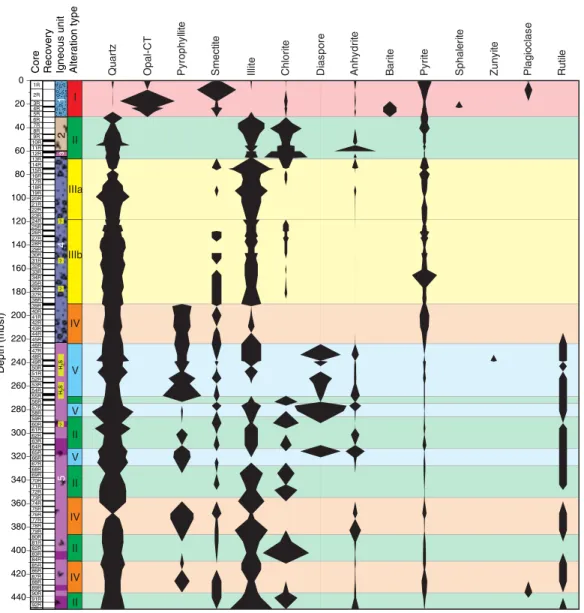
Fractures also dip moderately to steeply, from 37° to 90° (average = 68°). The density of veins and fractures is low but increases slightly downhole. Fractures almost always have a brown/orange alteration halo overprinting all other types of alteration, which indicates late formation of fractures. The presence of brown/orange alteration along fractures and defining Subtype IIb may indicate the ingress of seawater through late-forming fractures. Faults are observed only in Hole U1527C, dip steeply (45°–83°; average = 66°), and are most abundant in Igneous Subunit 2c. All faults are discrete centimeter- scale zones with a normal sense of shear. Shallowly dipping shears Figure F8. Distribution of alteration types and abundance of key minerals, Site U1527.
11
2R 3R 4R 5R 6R 7R 8R 9R 10R 11R 12R 13R 14R 15R 16R 17R 18R 19R 20R
220 200 180 160 140 120 100 80 60 40 20 0
Recovery
Core
Depth (mbsf)
U1527
1R 2R 3R 4R 5R 6R 7R 8R 9R 10R 11R 12R 13R 14R 15R
Casing2b
2c 2d
No recovery1Igneous unit
2a
II IIa and IIb III Ib
CasingIa Quartz
Opal-A Illite Smectite Chlorite Mordenite Pyrite
IaNo recovery
0Degree of alteration Alteration type 5
1
CASING
NO RECOVERY
are defined by elongated ribbons of white clays that may represent flattened and altered volcanic clasts. White ribbons wrapped around larger volcanic clasts may indicate some crystal-plastic de- formation. The shallowly dipping shears (average = 22°) are over- printed by higher angle brittle faults. The overall lack of veins and indication of late fracturing suggest that alteration is not structur- ally controlled and may instead be due to pervasive flow.
Unaltered volcanic rocks in Hole U1527A and the shallower sec- tions of Hole U1527C (Igneous Unit 1) represent dacites that are compositionally similar to those previously reported from Brothers volcano (e.g., Haase et al., 2006; Wright and Gamble, 1999; Timm et al., 2012). Most of the pervasively altered volcaniclastic rocks recov- ered from Hole U1527C (Igneous Unit 2) share the incompatible el- ement composition (i.e., Zr/Y and Zr/Ti) of overlying Igneous Unit 1 from the same hole. This suggests a common parental magma de- spite petrographic differences.
Geochemical analyses of the highly altered, variously colored volcaniclastic rocks demonstrate the mobility of alkali metals during high- and low-temperature hydrothermal alteration of the rock (Figure F10). Analyses of K2O, Rb, Ba, MgO, and SiO2 contents define a complex history of hydrothermal overprinting marked by multiple alteration stages. Alteration Type III displays significant enrichment in total sulfur content (as much as 1.9 wt%). Geochem- ical changes recorded in Hole U1527C are consistent with petro- graphic observations, including the formation of pyrite and replacement of groundmass and matrix by clay in deeper, more al- tered volcaniclastic rocks.
Organic carbon comprises the bulk of measured total carbon (TC) concentrations. Detectable only from 185 to 205 mbsf in Hole U1527C, this organic carbon may originate from seawater-derived fluid circulation and/or microbial biomass. Headspace analysis of pore space gases evolved from Hole U1527C hard rock samples in- dicates higher than ambient H2 contents that may have been pro- duced by mechanochemical sampling artifacts such as generation during RCB drilling and/or crushing rock samples prior to head- space sampling.
The two igneous units at Site U1527 have different natural re- manent magnetization (NRM) intensities before demagnetization;
samples from Igneous Unit 1 show more intense NRM (>0.5 A/m) than those from Igneous Unit 2. However, the direction of magneti- zation is consistent in both units, with an average inclination of Figure F9. Representative intervals of alteration types, Hole U1527C. Type Ia:
unaltered to slightly altered clast of dacite (376-U1527C-6R-1, 94–101 cm).
Type Ib: dark unaltered clasts of dacite with well-defined boundaries sur- rounded by altered yellow-brown matrix (11R-1, 0–6 cm). Type IIa: perva- sively altered clasts surrounded by chlorite-altered matrix (14R-2, 120–
138 cm). Type IIb: overprint of IIb onto IIa (14R-2, 4–20 cm). Type III: perva- sively altered clasts with resorbed, gradational boundaries (18R-1, 30–39 cm).
2 cm 2 cm
2 cm 1 cm
2 cm
Alteration Type Ia Alteration Type IIa Alteration Type IIb Alteration Type III
Alteration Type Ib
Figure F10. Variations of major element oxides compared with macroscopic estimate of degree of alteration, Holes U1527A and U1527C. Vertical lines = aver- age values of shallower unaltered Igneous Unit 1 in Hole U1527A. Dashed lines = 1σ from average values. The two shallowest samples correspond to relatively unaltered volcanic material recovered from the BHA in Hole U1527C.
0
50
100
150
200
250
0.00 2.00 4.00
Depth (mbsf) Recovery 0.0 5.0
K2O (wt%)
U1527A Unit 1 U1527C-BHA U1527C Unit 1 U1527C Unit 2b U1527C Unit 2c/d
0.0 2.0 4.0
MgO (wt%)
50.0 60.0 70.0 80.0 SiO2 (wt%) Alteration degree
−59°, which is very close to the inclination of a geomagnetic axial dipole (GAD) of −55° at the latitude of Brothers volcano. This con- sistent GAD inclination suggests a young age for these rocks, most certainly from the current normal polarity Brunhes geomagnetic epoch. Igneous Unit 1 also has significantly larger magnetic coerciv- ities than Igneous Unit 2. Thermal demagnetization experiments from Unit 2 show a more complex pattern compared to similar ex- periments from Igneous Unit 1 but indicate magnetite or titano- magnetite as the main magnetic mineral in both igneous units. In addition, susceptibility measurements and isothermal remanence magnetization (IRM) experiments suggest comparable magnetite content in both units, with a slight decrease in Subunits 2c and 2d.
The fresh dacitic volcanics of Igneous Unit 1 show an inverse correlation between porosity and bulk density, but no such correla- tion is observed between P-wave velocity and bulk density or P- wave velocity and porosity. Variably altered volcaniclastic rocks in Igneous Unit 2 display an inverse correlation between porosity and bulk density and between porosity and P-wave velocity. Mean bulk density (2.2 g/cm3), porosity (30%), and P-wave velocity (3330 m/s) generally show small variations throughout Unit 2 and do not ap- pear to be affected by transitions between alteration types. Alter- ation Subtypes IIa and IIb are clearly identifiable in reflectance colorimetry data. P-wave velocity sharply increases at the boundary between Subunits 2b and 2c (~4000 and 4200 m/s on section halves and discrete samples, respectively) followed by a downhole decrease in P-wave velocity to the bottom of Subunit 2c. In Subunit 2c, this variation in P-wave velocity is reflected in a similar trend in bulk density and matching inverse variation in porosity, which appears to be associated with deformation and shear in this unit.
Magnetic susceptibility measured on whole-round and sec- tion-half cores is consistent with discrete measurements. Mag- netic susceptibility in Igneous Subunits 2a and 2b is overall higher than that in Subunits 2c and 2d. Thermal conductivity ranges from 1.09 to 2.35 W/(m·K) (average = 1.72 W/[m·K]); Igneous Unit 2 has higher values than Igneous Unit 1. Thermal conductivity in Igne- ous Unit 2 varies over smaller scales, reflecting changes in type and distribution of alteration minerals. Thermal conductivity is lower where alteration is dominated by the presence of water-rich clay minerals (e.g., low of 1.53 W/[m·K] in Subunit 2b at ~203.40 mbsf ), whereas the highest thermal conductivity is observed along with increases in pyrite, silica, and magnetite concentrations in Subunit 2c. Hence, thermal conductivity data reflect the heteroge- neity of mineral compositions and alteration assemblages through- out the core.
Five whole-round samples (each 11– 20 cm long) collected from hydrothermally altered, relatively hard materials in Hole U1527C (Table T2) were processed and preserved as subsamples for shore-based biological investigations that will include quantifi- cation of microbial and viral biomass, molecular analysis of the microbial communities from extracted DNA and RNA, estimation
of microbial metabolic activity and viral production, and cultiva- tion of subseafloor microbial components. Quantification of the perfluoromethyldecalin (PFMD) contamination tracer was con- ducted for the drilling fluid and the exterior and interior parts of whole-round samples. PFMD was routinely detected, although barely above detection levels, suggesting that penetration of drill- ing fluids to the interior of whole-round samples was minimal.
Site U1528
Background and objectives
Site U1528 (proposed Site UC-1A) is located inside a small (~40 m diameter at the top, ~25 m diameter at the bottom) pit crater at the summit of the Upper Cone of Brothers volcano at a water depth of 1228 m (Figure F6). The primary objective at this site was to drill into the upflow zone of the Type II hydrothermal system that is strongly influenced by magmatic degassing. In this area, discharge of relatively gas rich, very acidic fluids has resulted in advanced ar- gillic alteration. Site U1528 addresses important Expedition 376 ob- jectives related to the role of magmatically influenced hydrothermal fluids in transporting metals to the seafloor and provides a compar- ison of fluid–rock reactions with the Type I seawater-dominated hy- drothermal system drilled at Sites U1527 and U1530.
Operations
We conducted operations in four holes at Site U1528 (Table T1).
Hole U1528A is located at 34°52.9177ʹS, 179°4.1070ʹE at a water depth of 1228.4 m. We used the RCB system to core from the sea- floor to 84.4 mbsf and recovered 17.1 m (20%). The downhole con- ditions encountered in Hole U1528A dictated the need to deploy a reentry system to achieve our objectives.
Hole U1528B is located 10 m south of Hole U1528A at 34°52.9222ʹS, 179°4.1077ʹE at a water depth of 1229.4 m. Here, we drilled-in 10¾ inch casing to 24.3 mbsf, with the drilling assembly penetrating to 25.6 mbsf. We had trouble extracting the drilling as- sembly from the reentry system, which ultimately took several hours. Because of drilling-induced suspension of sediment in the seawater, visibility was limited and we could see only the top of the reentry funnel, observed to be at a water depth of 1224.8 m, which was consistent with it being properly set on the seafloor. After two separate unsuccessful attempts to reenter Hole U1528B with both the RCB system and the CDEX turbine-driven coring system (TDCS), we suspended operations. Further visual observations showed the reentry system was sitting at a slight angle that pre- vented the drill string from passing through the throat of the reen- try funnel.
Our next objective was to perform the first offshore test of the TDCS. In Hole U1528C, located at 34°52.9215ʹS, 179°4.1128ʹE at a water depth of 1229.1 m, we drilled without coring using the TDCS to 22 mbsf and then cored to 53.5 mbsf, recovering 3.6 m (12%).
Further advancement was prevented by a broken core barrel that re- mained in the TDCS bottom-hole assembly (BHA), forcing aban- donment of Hole U1528C.
In Hole U1528D, located at 34°52.9219ʹS, 179°4.1164ʹE in the very limited flat central area of the pit crater and at a water depth of 1228.1 m, we drilled in 13⅞ inch (~35.2 cm) casing to 59.4 mbsf, with the drilling assembly penetrating to 61.3 mbsf. We then RCB cored to 359.3 mbsf and recovered 87.2 m (29%) under good hole conditions. After the bit reached 40 h of rotation time, when it would normally be changed before continuing to core, we instead decided to take downhole temperature measurements and obtain borehole fluid samples in the open hole through the existing bit.
Table T2. Microbiological whole-round samples collected and preserved during Expedition 376. Download table in CSV format.
Location Hole Samples (N)
NW Caldera (rim) U1527C 5
Upper Cone U1528A 3
Upper Cone U1528C 1
Upper Cone U1528D 13
NW Caldera (wall) U1530A 18
Lower Cone U1531C 1
The Elevated Borehole Temperature Sensor (ETBS) memory tool was deployed first and recorded a maximum temperature of 35°C at 357 mbsf, which was 2 m above the drilled bottom of the hole. The subsequent deployment of the 1000 mL Kuster Flow- Through Sampler (FTS) tool ended with its failure under compres- sion in the open hole. We then made an unsuccessful attempt to re- cover the tool with a fishing tool BHA equipped with boot-type junk baskets. Reentry into Hole U1528D was complicated by a plume emanating from the reentry funnel. We next deployed a log- ging BHA, lowered the backup 600 mL Kuster FTS tool on the core line, and successfully recovered a fluid sample from 279 mbsf. A subsequent ETBS downhole temperature measurement at the same depth recorded a maximum temperature of 212°C, confirming that the flasked wireline high-temperature triple combo (HTTC) log- ging tool string (natural gamma radiation [NGR], litho-density, and temperature tools) could be deployed. We successfully performed two upward logging passes from 323 mbsf. Another deployment of the 600 mL Kuster FTS tool then recovered a second borehole fluid sample from 313 mbsf; subsequent deployment of the ETBS mem- ory tool recorded a maximum temperature of 165°C (following cold seawater circulation). Next, we drilled down with a tricone bit BHA to clean out the hole to 356 mbsf, which was the depth of the top of the lost 1000 mL Kuster FTS tool.
A concave mill bit and two boot-type junk baskets were then de- ployed to attempt to remove the remaining parts of the lost 1000 mL Kuster FTS tool. After reentering Hole U1528D for the sixth time and despite very poor visibility around the reentry funnel, we advanced the mill bit to the bottom of the hole at 359.3 mbsf. Upon recovery, there was no evidence of the 1000 mL Kuster FTS tool in the boot baskets. The next fishing attempt used the reverse-circula- tion junk basket (RCJB) assembled in conjunction with the boot- type junk baskets. After the seventh reentry of Hole U1528D, we worked the RCJB BHA back to bottom (359.3 mbsf ), where we cir- culated 25 bbl of high-viscosity mud for ~15 min while working the RCJB up and down. When the end of the drill string cleared the rig floor, the discovery that the lowermost 172.8 m was missing ended Hole U1528D drilling operations. The drill string failed in a piece of 5 inch pipe above the BHA. The recovered broken piece showed sig- nificant damage directly attributable to the corrosive downhole en- vironment.
Upon completion of coring operations at Site U1531, we re- turned to Hole U1528D (~3 weeks later) to conduct a series of alter- nating downhole temperature measurements using both the ETBS memory tool and Petrospec spool-in thermocouple memory tool (TCMT) and two 600 mL Kuster FTS tool deployments that re- sulted in recovering a borehole fluid sample from 160 mbsf. Two successful temperature measurement runs recorded maximum temperatures of 198°C (ETBS) at 195 mbsf and 156°C (TCMT) at 160 mbsf. Site U1528 operations concluded with successful recov- ery of the failed Hole U1528B reentry system at the end of Expedi- tion 376. In total, 568.9 h, or 23.7 days, were spent at Site U1528.
Principal results
Rocks cored at Site U1528 are divided into three igneous units (Figure F11). Igneous Unit 1, recovered in Holes U1528A (0–6.03 mbsf ) and U1528C (26.50–31.41 mbsf ), consists of polymict lapilli tephra made up of subangular to subrounded volcanic clasts that have experienced varying degrees of alteration. Igneous Unit 2, re- covered in Holes U1528A (16.30–83.57 mbsf ), U1528C (35.50–46.00 mbsf ), and U1528D (61.30–269.30 mbsf ), is divided into three sub- units based on internal rock fabric and the presence of primary min-
erals. Subunits 2a and 2c are composed of sequences of altered lapillistones and lapilli-tuffs with subordinate intervals of altered tuffs and tuff-breccias. Clasts are volcanic in origin and altered to differing degrees; the matrix consists of secondary mineral assem- blages. Identification of original lithologies becomes increasingly dif- ficult with depth (especially in Subunit 2c). More coherent, massive dacite lava, affected by a lesser degree of alteration, occur between 152.90 and 160.17 mbsf and make up Subunit 2b. Igneous Unit 3, re- covered exclusively in Hole U1528D (162.50–269.03 mbsf ), consists of altered dacite lava with some relatively unaltered intervals.
The dacitic pyroclastic rocks and lavas at Site U1528 are perva- sively altered yet still show distinct similarities in petrography and whole-rock geochemistry to unaltered volcanic materials encoun- tered in Igneous Unit 1 at Sites U1527, U1529, and U1531 and to published descriptions and geochemical results for unaltered dacite recovered elsewhere at Brothers volcano (e.g., Haase et al., 2006;
Figure F11. Lithostratigraphic summary of Holes U1528A, U1528B, and U1528D in the pit crater of the Upper Cone.
11
2N 3N 4N 5N 6N 7N 8N
40 20 0
RecoveryCore
Depth CSF-A (m)
U1528C
2a 1
1R 2R 4R 5R 6R 7R 8R 9R 10R 11R 12R 13R 14R15R
80 60 40 20 0
Recovery
Core
Depth CSF-A (m)
U1528A
1
2a
U1528D
11
2R 3R 4R 5R 6R 7R 8R 9R 10R 11R 12R 13R 14R 15R 16R 17R 18R 19R 20R 21R 22R 23R 24R 25R 26R 27R 28R 29R 30R 31R 32R 33R 34R 35R 36R 37R 38R 39R 40R 41R 42R 43R 44R 45R 46R 47R 48R 49R 50R 51R 52R 53R 54R 55R 56R 57R 58R 59R 60R 61R 62R
360 63R
340 320 300 280 260 240 220 200 180 160 140 120 100 80 60 40 20 0
Recovery
Core
Depth CSF-A (m) Casing
2a
2b
2c
3 2
H2SH2SH2S
Volcaniclastics
Massive lava Altered volcaniclastics Young volcanics
Altered dacite lava
H2S H2S odor
Lithology Igneous unit Lithology Igneous unit Lithology Igneous unit