Pauline Snoeijs-Leijonmalm (SU), Hauke Flores (AWI), Filip Volckaert (KU Leuven), Barbara Niehoff (AWI), Fokje L. Schaafsma (AWI), Joakim Hjelm (SLU), Jonas Hentati-Sundberg (SLU), Susa Niiranen (SU), Anne-Sophie Crépin (KVA), Henrik Österblom (SU)
January – 2020
Review of the research
knowledge and gaps on fish populations, fisheries and
linked ecosystems in the Central Arctic Ocean (CAO)
author(s) and do not necessarily reflect the official opinion of EASME or of the Commission. Neither EASME, nor the Commission can guarantee the accuracy of the data included in this study. Neither EASME, nor the Commission or any person acting on their behalf may be held responsible for the use which may be made of the information contained therein.”
EUROPEAN COMMISSION
Executive Agency for Small and Medium-sized Enterprises (EASME) Unit A3 - EMFF
Contact: Rocio Suarez Jimenez
E-mail: EASME-EMFF-CONTRACTS@ec.europa.eu European Commission
B-1049 Brussels
Executive Agency for Small and Medium-sized Enterprises (EASME)
EASME/EMFF/2018/003:“Framework Contract for the Provision of Scientific Support to the High Seas Fisheries in the Central Arctic Ocean (CAO)”
2020
Review of the research
knowledge and gaps on fish populations, fisheries and
linked ecosystems in the
Central Arctic Ocean (CAO)
-20-046-EN-N
LEGAL NOTICE
This document has been prepared for the European Commission however it reflects the views only of the authors, and the Commission cannot be held responsible for any use which may be made of the information contained therein.
More information on the European Union is available on the Internet (http://www.europa.eu).
Luxembourg: Publications Office of the European Union, 2020
PDF ISBN 978-92-9202-810-7 doi:10.2826/387890 EA-03-20-046-EN-N
© European Union, 2020
Europe Direct is a service to help you find answers to your questions about the European Union.
Freephone number (*):
00 800 6 7 8 9 10 11
(*) The information given is free, as are most calls (though some operators, phone boxes or hotels may charge you).
Review of the research knowledge and gaps on fish populations, fisheries and linked ecosystems in the Central Arctic Ocean (CAO)
Snoeijs-Leijonmalm P1, Flores H2, Volckaert F3, Niehoff B2, Schaafsma FL4, Hjelm J5, Hentati-Sundberg J5, Niiranen S1, Crépin A-S7, Österblom H1
1 Stockholm University (SU), Sweden
2 Alfred-Wegener-Institute Helmholtz-Zentrum für Polar- und Meeresforschung (AWI), Germany
3 Katholieke Universiteit Leuven (KU Leuven), Belgium
4 Wageningen Marine Research (WMR), The Netherlands
5 Swedish University of Agricultural Sciences (SLU), Sweden
6 Royal Swedish Academy of Sciences (KVA), Sweden
Table of contents
Executive summary ... 4
1. Current status, climate change and possible future fisheries (Snoeijs-Leijonmalm P, Flores H) 1.1. Chapter summary... 5
1.2. Background ... 5
1.3. The CAO ecosystem is changing extremely fast ... 7
1.4. Fishable areas in the High Seas of the Arctic Ocean become accessible ... 7
1.5. The fish stocks in the CAO are unknown ... 8
1.6. Possible future fisheries in the CAO... 11
1.7. Future management of the CAO ... 11
2. The CAO and adjacent large marine ecosystems (LMEs) (Snoeijs-Leijonmalm P) 2.1. Chapter summary ... 12
2.2. Background ... 12
2.3. Summary of literature searches ... 16
2.4. Summary of knowledge ... 16
2.5. Critical gap analysis ... 19
3. Pelagic and benthic fish: species, population dynamics, distribution (Snoeijs-Leijonmalm P, Volckaert F) 3.1. Chapter summary ………... 20
3.2. Background ... 20
3.3. Summary of literature searches ... 21
3.4. Summary of knowledge ... 22
3.5. Critical gap analysis ... 24
4. Sympagic fish: species, population dynamics, distribution (Flores H, Volckaert F) 4.1. Chapter summary ... 25
4.2. Background ... 25
4.3. Summary of literature searches ... 26
4.4. Summary of knowledge ... 26
4.5. Critical gap analysis ... 29
5. Food web and trophic interactions (Niehoff B, Flores H) 5.1. Chapter summary ... 32
5.2. Background ... 32
5.3. Summary of literature searches ... 32
5.4. Summary of knowledge ... 33
5.5. Critical gap analysis ... 37
6. Fish species/populations and climate change impacts: northward migrations (Flores H, Schaafsma FL, Snoeijs-Leijonmalm P) 6.1. Chapter summary ... 39
6.2. Background ... 39
6.3. Summary of literature searches ... 40
6.4. Summary of knowledge ... 40
6.5. Critical gap analysis ... 43
7. Data needs for potential fisheries assessment and fish stock modelling (Hjelm J, Hentati-Sundberg J) 7.1. Chapter summary ... 45
7.2. Background ... 45
7.3. Summary of literature searches ... 45
7.4. Summary of knowledge ... 46
7.5. Critical gap analysis ... 48
8. Data needs for governance and socio-economic development of potential fisheries (Niiranen S, Crépin A- S, Österblom H) 8.1. Chapter summary ... 49
8.2. Background ... 49
8.3. Summary of literature searches ... 50
8.4. Summary of knowledge ... 50
8.5. Critical gap analysis ... 53
9. Recommendations on research priorities and the next steps (Snoeijs-Leijonmalm P, Flores H) 9.1. Chapter summary ... 55
9.2. Ecosystem Approach to Management ... 55
9.3. Holistic gap analysis ... 56
9.4. Recommendations on research priorities ... 58
References ... 61
Appendix: Fish species found in the Central Arctic Ocean and adjacent waters ... 73
List of Figures
Figure 1.1. Bathymetric map of the Arctic Ocean, showing the location of the Central Arctic Ocean (CAO) LME as defined by the Arctic Council (PAME 2013) and the High Seas area.
Figure 1.2. Changes in air temperature over time, showing that the Arctic region is warming faster than the rest of the globe.
Figure 1.3. Maps of the Arctic region showing the High Seas with the minimum ice cover in summer 2012 and the shallower parts of the High Seas that may be more “fishable” than the deep basins.
Figure 1.4. Map of contemporary marine fish data sources. Green squares indicate data from benthic trawl monitoring efforts, blue squares indicate data from benthic trawl surveys, while red triangles indicate data from pelagic trawl monitoring efforts.
Figure 2.1. Examples of vertical profiles of oceanographic variables in the CAO.
Figure 2.2. The Large Marine Ecosystems (LMEs) of the Arctic region as defined by the Arctic Council (PAME 2013).
Figure 3.1. Fish species recorded in the CAO according to FiSCAO (2017).
Figure 5.1. Conventional conceptualization of energy flow at the ice edge in the Arctic shelf seas; the food- web structure in the CAO is unknown but is expected to be different (e.g. without Atlantic cod and capelin).
Figure 5.2. Zooplankton biomass distribution in the Arctic Ocean.
Figure 8.1. An example of social-ecological interactions of an Arctic ecosystem.
Figure 9.1. The three main inputs to support an Ecosystem Approach to Management (ICES).
Figure 9.2. Radar chart summarizing the gap analyses presented in this Report.
Figure 9.3. Set-up of a vulnerability analysis by ICES that can be used as a model for further work within EFICA.
List of Tables
Table 2.1. The number of scientific publications found in the Web of Science Core Collection for the time span 1945-2019 with “Ocean”, “Arctic Ocean”, the Arctic Ocean’s LMEs as well as relevant shallow areas as search criteria (All) and “fish” or “fisheries” as additional search criteria.
Table 2.2. The 21 scientific publications on the Central Arctic Ocean found in the Web of Science Core Collection for the time span 1945-2019
Table 2.3. Critical gap analysis for variables relevant for ecosystem analyses and climate change impacts in the CAO.
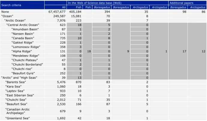
Table 3.1. The number of scientific publications found in the Web of Science Core Collection for the time span 1945-2019 with relevant geographical areas as search criteria (All) and “fish”, “Boreogadus”
or “Arctogadus” as additional search criteria.
Table 3.2. Critical gap analysis for variables relevant for species, population dynamics and distribution of pelagic and benthic fish in the CAO.
Table 4.1. Results of database research with search terms relevant for the sympagic habitat.
Table 4.2. Observations of ice-associated fishes in the Arctic Ocean.
Table 4.3. Critical gap analysis for variables relevant for species, population dynamics and distribution of sympagic fish in the CAO.
Table 5.1. Results of database research with search terms relevant for the food web and trophic interactions in the CAO.
Table 5.2. Relevant papers for the food web and trophic interactions in the CAO identified by the database research presented in Table 5.1.
Table 5.3. Critical gap analysis for variables relevant for the food web and trophic interactions in the CAO.
Table 6.1. Results of database research with search terms relevant for fish species/populations and climate change impacts, including northward migrations in the CAO.
Table 6.2. Summary of the distribution and commercial value of the 130 fish species that have been observed in the Arctic Ocean (Appendix 1).
Table 6.3. Critical gap analysis for variables relevant for fish species/populations and climate change impacts, including northward migrations in the CAO.
Table 7.1. Results of database research with search terms relevant for fisheries assessment and fish stock modelling in the CAO.
Table 7.2. Critical gap analysis for variables relevant for fisheries assessment and fish stock modelling in the CAO.
Table 8.1. Review of existing knowledge and data relevant for CAO fisheries governance and management.
Table 8.2. Critical gap analysis for variables relevant for governance and socio-economic development of fisheries in the CAO.
Table 9.1. Summary of research priorities relevant for fisheries assessment and fish stock modelling in the CAO.
List of abbreviations
CAFF Conservation of Arctic Flora and Fauna (a working group of the Arctic Council) CAO Central Arctic Ocean (the LME as defined by PAME)
CFP Common Fisheries Policy (EU) DM Dry Mass
EEZ Exclusive Economic Zone
EFICA European Fisheries Inventory in the Central Arctic Ocean FiSCAO Expert Group for Fishes in the Central Arctic Ocean ICES International Council for the Exploration of the Sea
LME Large Marine Ecosystem (developed by the US National Oceanic and Atmospheric Administration (NOAA) to identify areas of the oceans for conservation purposes) MSY Maximum Sustainable Yield
PAME Protection of the Arctic Marine Environment (a working group of the Arctic Council)
RCP Representative Concentration Pathway trajectory adopted by the IPCC in its Fifth Assessment Report (2015)
SES Social-Ecological System
Executive Summary
This report presents a review of the research knowledge and gaps on fish populations, fisheries and linked ecosystems in the Central Arctic Ocean (CAO). The CAO comprises the deep basins of the Arctic Ocean beyond the shelf break, which largely overlap with the High Seas of the Arctic Ocean, i.e. the marine areas outside the Exclusive Economic Zones (EEZs) of the Arctic coastal nations. The authors of the report are members of the European Fisheries Inventory in the Central Arctic Ocean (EFICA) Consortium. This study was funded by the European Commission as an EU contribution to the international cooperation within the Agreement to Prevent Unregulated High Seas Fisheries in the Central Arctic Ocean.
The report contains desk-based research, using scientific research data bases as well as any available research performed by the EFICA Consortium partners and EU institutions or others. In Chapters 2-8 the authors review the literature and identify specific
knowledge gaps. The gap analyses involve comparisons of actual knowledge with desired knowledge on the fish stocks of the CAO to be able to evaluate possibilities for future sustainable fisheries in the area. Chapter 1 is an introductory chapter, and Chapter 9 presents a holistic gap analysis based on Chapters 2-8 and recommendations for research priorities and the next steps.
The critical gap analysis highlights that the knowledge gaps for the CAO are enormous and obstruct any quantitative analyses of its fish stocks. This agrees with the conclusions from the Fifth FiSCAO Report (FiSCAO 2018). While data for the physical environment in the CAO (oceanography, bottom topography and ice-cover dynamics) would be sufficient for fish stock modelling and assessment, there is a massive lack of biological and
ecological data. The CAO is not a closed system and some aspects of the shelf seas are of high relevance for the CAO, notably connectivity of fish stocks and fish species moving north with climate warming. Scientific research and monitoring programs are established in the shelf seas, and new data are constantly being produced.
Fish stock data are available from scientific projects and monitoring programs for some of the shelf seas (Barents Sea, Bering Sea, and to a lesser extent for the Beaufort Sea and the Chukchi Sea). Data exist also for the Russian shelf seas (Kara Sea, Laptev Sea, East Siberian Sea), but these data are not internationally available, while for the areas north of Canada/Greenland data are missing; they do not exist because of the severe ice conditions there. More data from all shelf seas may be hidden in reports that are not publicly accessible. We recommend to make current knowledge generally available by translating key publications and identification of valuable data reports.
Research priorities comprise the collection and analysis of primary data in the CAO, and – to a limited extent – from adjacent waters through collaborations with other Signatories of the Agreement (e.g. on population genetics). Further research priorities include an evaluation of ecosystem vulnerability, social-ecological analyses, i.e. recognizing the close and often complex interactions between humans and nature, and recommendations for governance of the CAO. Fulfilling the 14 specific research priorities mentioned in Chapter 9 to “sufficient knowledge available” could enable the potential, future application of an Ecosystem Approach to Management for the CAO.
Acknowledgement
We are grateful to Hein Rune Skjoldal, Co-Chair of WGICA, for allowing to use the
unpublished WGICA list of fish species reported from the “wider CAO area”, i.e. including the adjacent shelves surrounding the basins (version May 2019), that he compiled for WGICA.
Chapter 1. Current status, climate change and possible future fisheries Pauline Snoeijs-Leijonmalm (SU), Hauke Flores (AWI)
1.1. Chapter summary
With the disappearance of the summer sea-ice cover and increasing territorial and commercial interests of governments and companies, the need for scientific advice on management of the Central Arctic Ocean (CAO) ecosystem, including potential fisheries, becomes urgent. Today there are no fisheries in the CAO because, except in some marginal areas for a few weeks in summer, the area is still inaccessible for fishing vessels. The Agreement to Prevent Unregulated High Seas Fisheries in the Central Arctic Ocean1 (hereafter referred to as “the Agreement”) aims to prevent commercial fisheries in the CAO while scientific mapping and monitoring of potential fish stocks is carried out.
These research activities are now starting up with the aim to map the existing potentially exploitable fish stocks and to explore possible future sustainable fisheries in the CAO.
1.2. Background
The 3.3 million km2 Large Marine Ecosystem (LME) around the North Pole, the Central Arctic Ocean (CAO; Figure 1.1), is a prominent blind spot on the map of the Earth’s fish stocks. The reason for the absence of data from the CAO is obviously the difficulty of accessing this remote cold area for on-site research due to its perennial 2-3 m thick ice cover. However, observations demonstrate that the Arctic sea ice cover has been in rapid decline over the last decades, and climate models predict a further decline, with ice-free summers starting to appear already within the next few decades (Duarte et al 2012, Screen & Williamson 2017). The speed of the Arctic sea ice reduction depends largely on political decisions made (Serreze & Meier 2019). The rapid environmental changes in the CAO create new opportunities for human activities that may impact ecological and social values, including potential future commercial fisheries. Most of the CAO belongs to the
“High Seas” area, i.e. being located beyond waters underlying national jurisdiction of the Arctic coastal states. Both the CAO and the Arctic High Seas consist mainly of deep abyssal plains and ridges, but the High Seas also contain a small portion (3 %) of
continental shelf (Figure 1.1, see also Chapter 2). Commercial fishing does not occur in the CAO today, because the yearly ice-free time window is still locally confined and short.
Furthermore, fish resources of potential commercial value have so far not been detected in the CAO.
Exploitation of newly accessible natural resources tends to precede scientific research and effective management measures, and especially internationally shared fish stocks in High Seas are prone to overexploitation (McWhinnie 2009, Christiansen et al. 2014, van Pelt et al. 2017). Therefore, a precautionary approach has recently been taken for the CAO before any exploitation of its fishery resources has taken place. In October 2018, nine countries (including the five coastal states) and the EU decided to put “science first”
and abstain from engaging in commercial fishing for the next 16 years by signing the Agreement1 (Hoag 2017, Van Pelt et al. 2017). The Agreement will enter into force when all 10 signatories have ratified it. By October 2019, the Agreement was ratified by
Russia, EU, Canada, USA, Japan and South Korea, while ratification of the four other Signatories is expected in 2020.
1Agreement to prevent unregulated high seas fisheries in the Central Arctic Ocean (Official Journal of the European Union L 73, 15.3.2019, pp. 3-8)
Figure 1.1. Bathymetric map of the Arctic Ocean (Jakobsson et al. 2012), showing the location of the Central Arctic Ocean (CAO) Large Marine Ecosystem as defined by the Arctic Council (PAME 2013) (white line) and the High Seas area (yellow line). The CAO is defined based on ecosystem characteristics (the oligotrophic deep basins of the Arctic Ocean and ingoing ridges) while the High Seas are defined as the area north of the Exclusive Economic Zones of the coastal states of the Arctic Ocean. The surface area of the CAO is ca. 3.3 million km2 and that of the High Seas is ca. 2.8 million km2.
During the preparatory phase of the Agreement, scientific advice to the Signatories was provided by five ad-hoc meetings of the expert group for Fishes in the Central Arctic Ocean (FiSCAO), consisting of scientists from the countries involved (FiSCAO 2017, 2018). During the First Preparatory Meeting of the Signatories to the Agreement to Prevent Unregulated High Seas Fisheries in the Central Arctic Ocean in Ottawa, Canada (29-30 May 2019) it was decided that, until all Signatories have ratified the Agreement, an interim Provisional Scientific Coordination Group (PSCG) would be installed to
organize the Mapping and Monitoring Program. The first meeting of the PSCG is planned to take place in Ispra, Italy on 11-13 February 2020. In November 2019, a workshop was held in Yellowknife, Canada2 on the processes and mechanisms to include local and indigenous knowledge into the Mapping and Monitoring program of the Agreement.
The EFICA Consortium contributes to the Mapping Program of the Agreement by joining two expeditions with the RV Polarstern and the RV Oden to the CAO in 2019-2020. Using already planned oceanographic icebreaker expeditions to the CAO is a pragmatic and relatively inexpensive approach to collect crucial fish data to fulfil the requirements of the Mapping Program and perhaps also for the future Monitoring Program.
Besides studies in the CAO itself, there are several aspects in which existing monitoring data in the gateways and shelf seas of the Arctic Ocean can be used for better
understanding and predicting future developments of the fish stocks in the CAO. The two main uses of monitoring data are on (1) connectivity between fish stocks (coastal
spawning areas) and (2) northward movement of fish species to the CAO with climate change. This requires a detailed review of the existing literature about northward
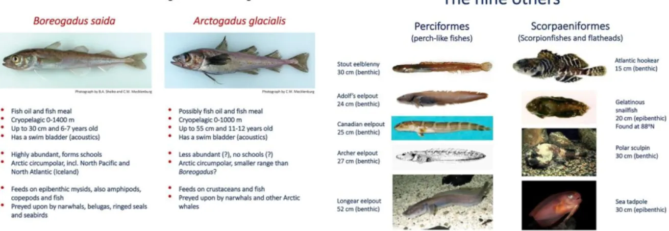
migrations (see Chapter 6). Data on spawning areas needs to be extended but that can only be done if we know which species occur in the CAO. We expect possible CAO fish stocks of commercial interest to be Boreogadus saida (polar cod) and Arctogadus
2Workshop on the Co-Development of Indigenous Knowledge for the Central Arctic Ocean Agreement, 13-14 November 2019, Yellowknife, Canada
glacialis (ice cod), but we cannot be sure (see Chapters 3 and 4). Both are single species in their genus and are referred to as Boreogadus and Arctogadus, respectively, hereafter. To understand the ecology of the potential fish stocks in the CAO and their possible future sustainable harvesting, it is also necessary to identify their role in the food web (see Chapter 5).
1.3. The CAO ecosystem is changing extremely fast
Global warming and ocean acidification change the habitats of the cold-adapted
organisms living in the Arctic, with the risk of exterminating unique biodiversity. Human- induced emissions of greenhouse gases (primarily carbon dioxide, methane and nitrous oxide) affect the balance between energy entering and leaving the Earth’s system resulting in global warming, melting of sea-ice (which increases heat absorption by the Arctic Ocean), and associated climate change (IPCC 2013). Approximately 27 % of the carbon dioxide released to the atmosphere every year is absorbed by the oceans. This keeps the atmosphere from warming as much as it otherwise would, but results in ocean acidification (i.e. decrease of seawater pH and carbonate ion concentration due to CO2
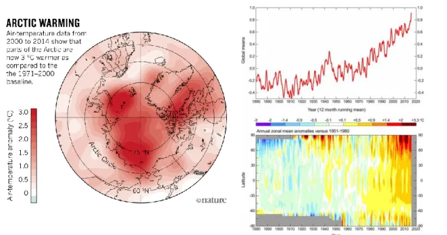
absorption). In the Arctic region, climate change and ocean acidification take place 10- 100 times faster than at any time in the past 65 million years. The Arctic region is warming faster than the rest of the globe, a process called Arctic amplification (Figure 1.2), caused by (1) decreased albedo when the sea ice disappears and (2) increased air and water transport from lower latitudes. Models agree on the Arctic amplification and on the loss of the summer sea ice in the CAO in this century, but disagree on both the magnitude and the exact locations where the change will be largest (IPCC 2018).
With the decrease of the summer sea-ice cover in the CAO, the only large permanently ice-covered ecosystem on Earth is vanishing. The CAO is becoming a more dynamic ecosystem with global warming, as the marginal ice zone moves further north in summer and south again in winter. The extent of both the minimum summer and winter sea ice cover has consistently been breaking negative records during the past decades: the minimum summer Arctic sea ice extent has decreased with an estimated loss rate of ~1 million km2 (~13.2%) per decade between 1979 and 2017 (IPCC 2013, Barnhart et al.
2015, Ding et al. 2017). Simultaneously, the sea ice is also thinning (Laxon et al. 2013), with an estimated loss rate of ~3,100 km3 (~13.5%) per decade over the period 1979 to 2017. Climate models for the Arctic region predict a further decline of the summer sea- ice cover to below 1 million km2 within the coming 30 years, depending on which political decisions are made and implemented at a global scale (Duarte et al. 2012, Screen &
Williamson 2017).
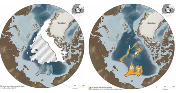
1.4. Fishable areas in the High Seas of the Arctic Ocean become accessible Approximately 20 % of the High Seas of the Arctic Ocean consists of shallow waters of 2,000 m depth or less, while 80 % consists of deep basins (Fig. 1). The CAO is a fairly uniform ultra-oligotrophic ecosystem, i.e. with very low productivity due to low nutrient levels. Pelagic fishing would be possible in the whole area if the sea ice cover would disappear, and even bottom trawling would be possible in the larger shallow areas such as the Lomonosov, Alpha and Mendeleev Ridges. The Arctic coastal seas, except for parts of the Beaufort Sea, are situated on the continental shelves and contain most of the continental slope areas. They are influenced by land-based activities and generally nutrient-rich.
Figure 1.2. Changes in air temperature over time, showing that the Arctic region is warming faster than the rest of the globe [Nature Climate Change 7:230 (2017) and
https://data.giss.nasa.gov/gistemp].
The Chukchi Plateau and the more coastal part of the Mendeleev Ridge are excluded from the CAO LME, but are still part of the High Seas. These are also the two shallow areas of the High Seas that already today are ice-free for several weeks in summer (Figure 1.3).
The North-Pole area is predicted to become fully ice-free in summer during the coming decades, while the sea ice North of Greenland and Ellesmere Island (Canada) is expected to stay permanently ice-covered for the longest time (Screen & Williamson 2017). This means that, within the Arctic High Seas, productive areas that may be amenable for trawling are already accessible, and may soon extend into the CAO, with potential grounds for pelagic fishing along the continental slopes and within the central basin opening up during summer (Christiansen et al. 2014, Christiansen 2017). Today, the presence and future potential of commercially interesting fish stocks in these areas is unknown. Taking into account the water currents in the CAO and its distance from land, it is not expected that the CAO will become richer in nutrients with global warming (Tremblay et al. 2015). However, it is expected that even if these potentially “fishable”
regions would become accessible, low levels of primary and secondary productivity would probably not be sufficient to support potential commercially relevant fish stocks.
1.5. The fish stocks in the CAO are unknown
The Arctic marine fish fauna is comprised of about 250 species, of which the majority are shelf-associated (Christiansen & Reist 2013). In shallow waters, monitoring activities with strongly varying efforts in space and time have generated an overall moderate to good knowledge of the fish stocks on the Arctic shelves (Fossheim et al. 2015,
Mecklenburg & Steinke 2015, Antonov et al. 2017, Chernova 2018). Fish data from the nutrient-rich Arctic shelf seas cannot however be extrapolated to the oligotrophic (still) permanently sea ice-covered deep basins of the CAO and remote shallower areas, such as the central Lomonosov Ridge. This is due to the assumption that the carrying capacity of the oligotrophic CAO to support fish stocks is very limited (Tremblay et al. 2015), and that most species are not adapted to the deep-sea habitat.
Records of fish observations have so far been sporadic and from spatially isolated study areas, mostly using non-quantitative sampling gear from drifting sea-ice stations (Andriyashev 1957, Andriyashev et al. 1980, Tsinovsky 1980, 1981). Icebreakers with echosounders or specialized trawls have only very recently been used to detect fish in
Figure 1.3. Maps of the Arctic region showing the High Seas (red line) with the minimum ice cover in summer 2012 (white area in the left map) and the shallower parts of the High Seas (yellow area in the right map) that may be more “fishable” than the deep basins. L = Lomonosov Ridge, A = Alpha Ridge, M = Mendeleev Ridge, C = Chukchi Plateau. Left: PEW map based on sea ice data from the University of Bremen SSMIS Sea Ice Data (www.iup.uni-bremen.de:8084/ssmis). Right:
PEW map based on fishable depths derived from IBCAO v3 bathymetry (www.ngdc.noaa.gov/mgg/bathymetry/arctic).
the CAO (David et al. 2016, Snoeijs-Leijonmalm et al., unpublished). Hence, there is evidence of only 12 fish species occurring in the CAO (FiSCAO 2017). More fishes could potentially live there based on their known habitat, behaviour and physiological
demands, but have not been documented in the CAO so far. The only two species with historically consistent records indicating a widespread distribution in the CAO are
Boreogadus saida and Arctogadus glacialis that that live associated with the underside of the sea ice (Andriyashev 1957, Andriyashev et al. 1980, Tsinovsky 1980, 1981, Melnikov
& Chernova 2013, David et al. 2016). On the abyssal seafloor and in the slopes of the central ridge system, there is potential for benthic fishes to occur, such as snailfishes Liparis spp. and eelpouts Lycodes spp. (see Chapter 3). Furthermore, lanternfishes (Myctophidae) can be expected to dwell in the mesopelagic habitat based on their distribution ranges and the connectivity of the mesopelagic layer along the Atlantic gateway (Mecklenburg et al. 2018).
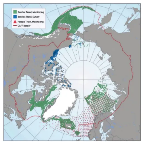
Reliable data on fish stocks are generally scarce in the Arctic Ocean. A recent inventory (CAFF 2017) reported sporadic or absent monitoring of fish communities in six out of eight sectors of the Arctic Ocean. Monitoring is sporadic or absent in the Arctic Basin (CAO), the Kara-Laptev Sector, the Beaufort sector, the Hudson Complex Sector, the Davis-Baffin Sector, and the Canadian Arctic Archipelago sector. In contrast, the Atlantic Arctic (including the Barents Sea) and Pacific Arctic (including the Bering Sea) are
covered by monitoring (Figure 1.4). In the CAO, there have been no systematic, quantitative surveys of fishes. Hence, there is no sound information about the
distribution ranges, migration patterns and population sizes of any fish species living in the CAO. Therefore, there is currently no scientific basis for a sustainable management system in the CAO and the bordering shallow waters of the Arctic High Seas (FiSCAO 2018).
Figure 1.4. Map of contemporary marine fish data sources. Green squares indicate data from benthic trawl monitoring efforts, blue squares indicate data from benthic trawl surveys, while red triangles indicate data from pelagic trawl monitoring efforts. Figure from Hedges et al. in CAFF (2017).
The CAFF (2017) report presented the following conclusions with respect to (changes in) the fish populations of the Arctic Ocean and adjacent areas within the CAFF area (Figure 1.4):
• Pelagic and benthic fish species are important in Arctic marine ecosystems because they transfer energy to predators such as seabirds, marine mammals, as well as people.
• Northward range expansions are underway and pose unknown consequences for Arctic species and their interactions such as predation and competition.
• Fishes are affected by environmental conditions such as temperature, sea ice and salinity, and are constrained by prey availability and predator pressure, which can be influenced by climate change.
• The ecologically important polar cod declined in the Barents Sea from 2004 to 2015, potentially because of predation from Atlantic cod, a temperate-boreal species. A 2016 survey showed a notable increase in abundance, driven by an unusually high
abundance of one-year-old fish.
• Indices and monitoring programs based on harvested species or that rely on fishery- related data are inherently affected by changes in stock size and exploitation rate, making them imperfect sources of information.
• Northward expanding capelin is less lipid-rich and has led to changes in seabird diet in northern Hudson Bay and may affect marine mammals negatively.
• Greenland halibut have undergone declines and subsequent recoveries over the last two decades in the northeast Atlantic.
1.6. Possible future fisheries in the CAO
Global models project an increased catch potential of potential future fisheries in the Arctic, including the CAO (Cheung et al. 2016). It has even been predicted that
biodiversity of potentially exploited fish and invertebrates will increase in the CAO due to temperature-driven northwards movement of species as well as increased biological production (Jones & Cheung 2015). It is difficult, however, to evaluate the performance of these models for the CAO due to shortage of ecosystem and fisheries data.
Most Arctic fishes are not directly associated with the sea ice, but constitute an integral part of the seafloor biota. Along the shelves and slopes of the Arctic Ocean, Arctic demersal fishes may temporarily benefit from improved feeding conditions but may also be threatened by new predators, such as invading boreal fishes and mammals. Increased human activity through emerging industrial enterprises on the Arctic shelves will act as an additional stressor. Boreogadus, on the other hand, an abundant and prominent member of the ice-associated biota, uses sea ice as spawning substrate, shelter and feeding ground. Thus, loss of sea ice has severe and explicit costs for this focal species with profound ecological consequences (Christiansen 2017) (see Chapter 4).
Due to ocean warming and loss of Arctic sea ice, harvested marine fishes of boreal origin (and their fisheries) may move poleward into yet unexploited parts of the Arctic seas (Christiansen et al. 2014). Local fish stocks on the Arctic shelves are subject to
commercial fisheries, e.g. in the Barents Sea (Eide et al. 2013) and Kara Sea (Antonov et al. 2017). They are also affected by changes in composition by northward movements of boreal fishes, as global warming drives changes in oceanographic conditions in the Arctic Ocean and the adjacent continental slopes (Fossheim et al. 2015; see Chapter 6). This may result in favourable conditions for increased biological production in waters at the northern continental shelves. However, overall production in the CAO will continue to be limited by the low amount of light and vertical stratification that is likely to become more marked with global warming (i.e. warming of the upper layer). Overall, this will reduce nutrient circulation.
The probability of fish stocks to establish themselves in the CAO depends not only on food availability, but also on the potential to provide habitat and to allow successful reproduction and recruitment of juveniles. Considering these aspects, Hollowed et al.
(2013) evaluated 13 species of commercially harvested finfish and shellfish to have a moderate to high potential of range expansion into the Arctic Ocean. A high potential for expansion or range shift beyond the shelf edge into the CAO, however, appears to apply only for Sebastes mentella (beaked redfish), Reinhardtius hippoglossoides (Greenland halibut) and the pan-Arctic Boreogadus saida (Christiansen 2017, Haug et al. 2017).
1.7. Future management of the CAO
Increasing economic activity in the CAO is in the interest of multiple stakeholders. Hence, in addition to environmental change driven by global warming, the CAO fish stocks are potentially subject to other stressors including oil and gas exploitation, mineral
extraction, shipping and tourism. Consequently, maintaining a healthy CAO ecosystem that could possibly support fisheries requires the combined management of multiple economic sectors. A future coherent international management regime for the CAO is not entirely obvious as the area is subject of geostrategic, political and economic pressures.
The Agreement, including its scientific mapping and monitoring programs of potential fish stocks in the CAO, is an important first step for building an international management regime.
Chapter 2. The CAO and adjacent large marine ecosystems (LMEs) Pauline Snoeijs-Leijonmalm (SU)
2.1. Chapter summary
The CAO is not a closed system. Its borders are defined as the continental slopes that pass over to eight large marine ecosystems (LMEs) situated on the continental shelves:
the Barents Sea, Kara Sea, Laptev Sea, East Siberian Sea, Chukchi Sea, Beaufort Sea, Canadian Arctic Archipelago (or Northern Canadian Archipelago) and the Greenland Sea.
To be able to model and assess the fish stocks in the CAO it is necessary to have data on connectivity with the fish stocks in the surrounding shelf seas (e.g. spawning areas, migration). From a literature search, it was concluded that the CAO is heavily under- investigated with respect to fish but also that the Agreement has raised the scientific interest in possible future fisheries and fisheries management in the area. The fish stocks of the Barents Sea are best known and adequately monitored, followed by those of the Beaufort and Chukchi Seas. Little has been published in the international literature about the fish stocks in the Russian Kara, Laptev and East Siberian Seas: knowledge probably exists but is not internationally accessible. The area north of the Canadian Arctic
Archipelago and Greenland is the least accessible area of the Arctic Ocean – with the toughest sea-ice conditions – and fish-stock data for this area do not exist.
2.2. Background
The Arctic Ocean is an important part of the global climate system as a constituent of the meridional overturning and global “conveyor belt” circulation (Böhm et al. 2015, Buckley
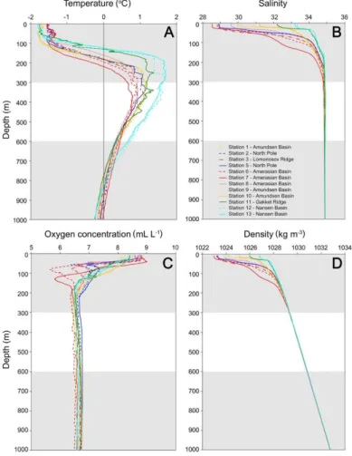
& Marshall 2016). Atlantic water – partly originating from the Gulf Stream – flows into the Arctic Ocean where it is cooled and modified and returned as cold over-flow water into the deep North Atlantic Ocean. The oceanographic processes in the North Atlantic and Arctic Oceans have received much attention in the context of climate variability and global climate change (e.g. Aagaard & Carmack 1994, Carmack & McLaughlin 2011, Mauritzen et al. 2011). The Arctic Ocean consists of four vertical layers of waters or water masses (Coachman & Barnes 1961, Rudels et al. 1991, 2004):
1. A surface layer about 50 m thick of low salinity water that is seasonally modified by sea-ice formation and melting (polar mixed layer).
2. A gradient layer (halocline) with strong increase in salinity and density between the surface layer and the next layer of Atlantic water below, located typically from about 50 to about 200 m depth (Figure 2.1).
3. An intermediate thick layer of relatively warm (temperature above 0 oC) Atlantic water below the halocline down to about 1,000 m.
4. Deep water of relatively uniform character (temperature between -0.5 and -1.0 oC and salinity around 34.9) filling the deep basins below the Atlantic layer.
The water circulation in the Arctic Ocean is driven by Atlantic water entering through Fram Strait and the Barents Sea, and Pacific water entering through the Bering Strait and the Chukchi Sea (Coachman & Barnes 1961, 1963, Aagaard et al. 1985, Aagaard 1989).
The ratio of these two inflowing water masses is roughly 5:1. The Pacific water has lower salinity (and density) than the Atlantic water (salinity around 31-33 compared to nearly 35) and is found mainly in the upper and mid halocline layer in the Canada Basin. The Atlantic water flows into the Arctic Ocean with two main branches (Fram Strait and Barents Sea) and circulates counter-clockwise as a set of boundary currents around the slopes of the Arctic Ocean basins (Aagaard 1989, Rudels et al. 1999, 2004, Rudels &
Friedrich 2000).
Figure 2.1. Examples of vertical profiles of oceanographic variables in the CAO.
Measurements were made between 15 August and 15 September during the Arctic Ocean 2016 expedition with RV Oden in the upper 1000 m of the water column. (A) Water temperature. (B) Salinity. (C) Oxygen concentration. (D) Density. Figure: Snoeijs-Leijonmalm et al. (unpublished).
Figure 2.2. The Large Marine Ecosystems (LMEs) of the Arctic region as defined by the Arctic Council (PAME 2013).
The Arctic Council Working Group PAME has – based on ecological boundaries – defined the LMEs of the Arctic region as follows (PAME 2013; Figure 2.2):
The CAO is the largest of the Arctic LMEs with an area of 3.3 million km2. It comprises essentially the deep basins of the Arctic Ocean with the Lomonosov Ridge separating the Eurasian and Amerasian basins. The key features of the CAO are the deep basins and the drifting pack ice that covers the whole area during both winter and summer, except for some of the more recent summers with especially low ice cover (Figure 1.3). The sea ice constitutes the habitat for cold-adapted microbial communities and a partly endemic fauna of ice amphipods and other invertebrates. Polar bears of several subpopulations move with the ice to live in the peripheral portions of the pack ice during the late summer season. This habitat is also used by two of the high arctic ice-associated gulls, Pagophila eburnea (ivory gull) and Rhodostethia rosea (Ross’s gull). PAME (2013) defined the CAO LME essentially as what is left when the Arctic shelf LMEs are defined.
For the LMEs on the Eurasian side – the Barents Sea, Kara Sea, Laptev Sea and East Siberian Sea – their outer boundaries include the upper slope with the Atlantic water layer and the slope currents flowing east along the continental margin. The boundaries have been approximated as straight-line segments following roughly the 1,000 m
isobath. The Barents Sea includes the Yermak Plateau and also the Sofia Deep east of it.
The rationale for these outer boundaries is that the slope current of Atlantic water plays important roles for the oceanography and ecology of the adjacent shelves, e.g. by transporting the copepod Calanus hyperboreus to deeper parts of the shelves. For the Chukchi Sea LME, the boundaries include the Chukchi Borderland with Northwind Ridge, the Chukchi Rise and the deep area in between. The northern boundary of the Beaufort Sea is along 76 oN, which approximates the average summer minimum sea-ice
distribution during the recent decades. The northern boundary of the Canadian High Arctic-North Greenland LME follows the shelf edge, approximated roughly by the 200 m isobath.
The Barents Sea LME is a shelf sea with an average depth of 230 m. Atlantic water flows with two main branches into the Arctic Ocean, one branch flowing across the Barents shelf and exiting via the northern Kara Sea, and the other flowing around the shelf plateau west and north of Svalbard. This flow pattern determines the oceanographic regimes with warmer boreal and ice-free conditions in the southwestern part of the Barents Sea and cold and ice-infested conditions in the northern and eastern parts. There are distinct differences in zooplankton composition and communities, with Calanus
finmarchicus being a dominant copepod in the Atlantic water while Calanus glacialis is its counterpart in Arctic water. The Barents Sea hosts large fish populations, including Atlantic cod (Gadus morhua), haddock (Melanogrammus aeglefinus), Greenland halibut (Reinhardtius hippoglossoides), capelin (Mallotus villosus) and polar cod (Boreogadus saida). The capelin forms a strong ecological linkage between the southern and northern Barents Sea by migrating northward in summer to feed on the zooplankton in the colder northern waters. Seasonal migrations are also characteristic for most other fish
populations. The Barents Sea LME contains a large population of harp seals that whelp at the entrance to the White Sea. The LME is also home to the Barents Sea subpopulation of polar bears and two populations of walrus, the Svalbard-Franz Josef Land population and the Kara Sea-southern Barents Sea-Novaya Zemlya population. Several subpopulations of belugas (white whales) are found in the White Sea and the eastern and northern parts of the Barents Sea.
The Kara Sea LME is a shallow shelf sea (average depth 131 m). At its low-lying coasts, the estuaries of two of the major Arctic rivers, the Ob and the Yenisei, are found. These rivers discharge large volumes of freshwater that strongly influences the hydrography of the Kara Sea, resulting in extensive areas of brackish water in the summer season. The Kara Sea LME is ice-covered in winter but is generally devoid of ice in summer except for the northernmost areas. It is home to the Kara Sea subpopulation of polar bears and it contains important feeding areas for summer aggregations of belugas. The northern Kara Sea is the breeding area for the largest part of the global population of ivory gulls.
The Laptev Sea LME is situated in the central part of the Russian Arctic and has an average depth of 578 m. The northern boundary of the Laptev Sea follows along the outer slope to the Arctic Ocean basins. This area constitutes the eastern margin of the Eurasian Basins (Nansen and Amundsen) and steers the flow of Atlantic water on its way into the Arctic Ocean. A prominent feature of the Laptev Sea is the “Great Siberian Polynya” which is a system of leads and polynyas (unfrozen sea within the ice pack kept open by strong currents and/or winds), stretching from off the Taymyr Peninsula in the west to off the New Siberian Islands in the east. This polynya system provides important spring staging and feeding habitats for migratory birds, and probably also for the Laptev walrus population. The LME is also home to the Laptev Sea subpopulation of polar bears.
There is possibly a migratory population of Boreogadus in the western part of the LME that serves as a summer feeding area for belugas of the Karskaya population wintering in the Barents Sea (Boltunov & Belikov 2002). There are several river deltas and estuaries along the southern mainland, with the Lena delta as the most prominent feature. These estuaries and deltas constitute important breeding, feeding and staging habitats for migratory birds.
The Northern Bering-Chukchi Sea LME is a shallow shelf sea with depths of 50-70 m or less extending >1,000 km from the shelf edge. The area is characterized by a
persistent northward flow of water driven by higher water level in the Bering Sea than in the Arctic Ocean. The Pacific water is nutrient-rich – about three times that of North Atlantic water – and the combination of northward flow and shallow topography drives very high primary production rates in the Bering Strait region of up to 500 g C m-2 per year or more. This makes the region a global hot spot in terms of production, comparable to upwelling systems. The area is ice-covered in winter but ice-free in summer except for the northern part of the Chukchi Sea in cold years. Boreogadus is an important fish species here (Lowry & Frost 1981, De Robertis et al. 2017).
The Beaufort Sea LME has an average depth of 124 m and consists of three main components: the southern part of the deep Canada Basin, the shelf along northern Alaska and northwestern Canada, and the southwestern part of the Canadian Arctic Archipelago. Prominent features are the Mackenzie River delta and estuary and the Bathurst Polynya in the Amundsen Gulf. Primary production is relatively high due to influence of nutrient-rich Pacific water, and zooplankton residing in the deeper offshore areas provides important couplings to higher trophic levels. There is probably a large migratory population of Boreogadus in the eastern Beaufort Sea, which is a major summer feeding area for large numbers of bowheads and belugas from migratory populations wintering in the Bering Sea (Braham et al. 1984).
The Canadian High Arctic-North Greenland Sea is strongly influenced by heavy multi-year pack ice that is transported into the Sverdrup Basin from the Central Arctic Ocean through the openings between the northern Queen Elisabeth Islands (east of Ellesmere Island). The Nares Strait between Ellesmere Island and Greenland is one of the connections between the Arctic Ocean and Baffin Bay. The production in the LME is
generally low due to the heavy ice conditions. Two polar bear subpopulations live in the area, one on each side of Ellesmere Island: the Norwegian Bay and Kane Basin
subpopulations. Narwhals that summer in Smith Sound move into Kane Basin and
possibly further north in the Nares Strait. Otherwise, the whales and seals of large stocks of the Baffin Bay region do not move into this ice-choked area. The coasts of northern Greenland along with Ellesmere and Axel Heiberg islands are breeding grounds for Branta bernicla (brent goose) and several species of high Arctic shorebirds, such as Calidris canutus (red knot), Calidris alba (sanderling), Calidris maritima (purple sandpiper), Arenaria interpres (ruddy turnstone) and Charadrius hiaticula (common ringed plover).
These birds belong to populations that fly east to winter in western Europe or West Africa.
The Greenland Sea-East Greenland Sea consists of three distinct portions, the Greenland Sea, the western Denmark Strait, and the Southeast Greenland Shelf. The cold East Greenland Current running from the Arctic Ocean through the Fram Strait, is a prominent oceanographic feature, as is the gyre circulation within the Greenland Sea.
Most of the area is covered with sea ice in winter. Boreogadus is an important fish species, and the LME constitutes important breeding and feeding habitat for populations of harp and hooded seals. It is also the home of the East Greenland subpopulation of polar bears.
Physiographic provinces in the Central Arctic Ocean (CAO) and the High Seas are very similar because of the large overlap between the two areas. Both areas consist mainly of abyssal plains and ridges, but the CAO includes more rises while the High Seas includes a small area of continental shelf (Jakobsson et al. 2003). In addition to abyssal plains and ridges both areas contain submarine highlands, continental rises, continental slopes, and continental shelves, the categories perched abyssal plains, perched continental rises and isolated basins. Perched means that the province is bathymetrically elevated in relation to nearby provinces and the isolated basin was used to describe a smaller
bathymetrically enclosed basin.
2.3. Summary of literature searches
To roughly summarize the existing scientific knowledge about fish and fisheries in the CAO and adjacent ecosystems, a comparison was made of the scientific publications containing the word “fish” or “fisheries” for all oceans, the Arctic Ocean (the CAO and all the shelf seas) and the CAO. These searches are full text searches and indicate any connection of the paper with fish – even if the connection is minimal, including when the words “fish” and “fisheries” occur in reference lists or author addresses.
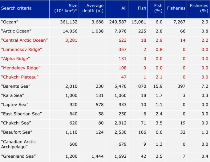
This comparison shows that 15,081 (6.0 %) of the 249,587 scientific publications on the global ocean are connected to fish and fisheries (Table 2.1). Of the 15,081 scientific publications connected to fish and fisheries globally, 870 (5.8 %) mention the Barents Sea, which shows that this is a very well-studied area with respect to fish and fisheries.
Another relatively well-studied area of the Arctic Ocean is the Beaufort Sea with 166 (1.1
%) papers, while the others score <0.5 %. Comparing 7,267 papers on fisheries with 15,081 papers on fish, ca. 50 % of the publications connected to fish in the global ocean deal with fisheries. For the Arctic Ocean this is ca. 30 % (indicating relatively more basic research on fish) and in the Central Arctic Ocean ca. 80 % (nearly all 18 publications are about the Agreement). Although a few publications were missed in this literature search (e.g. Melnikov & Chernova 2013), this shows that the CAO is heavily under-investigated with respect to fish but also that the Agreement has raised the scientific interest in possible future fisheries and fisheries management in the area without existing basic knowledge about the fish in the CAO ecosystem.
2.4. Summary of knowledge
A search in the Web of Science does not reflect everything that is known about fish and fisheries in the CAO and adjacent areas because data can be hidden in the “grey
literature” that is not internationally accessible or as unpublished data in (national) databases (see Chapters 3 and 4). However, this analysis provides a good impression for which of these areas the scientific basis would be sufficient for evaluating the fish stocks from biological, management and social-ecological system (SES) perspectives.
We know very little about the CAO. After scrutinizing the 21 publications found on the CAO and the High Seas (red areas in Table 2.1), 16 publications were relevant for fish, fisheries or environmental protection (Table 2.2), but only three present original data on fish in the CAO or the High Seas. David et al. (2016) report on the sympagic (ice-
associated) distribution of Boreogadus in the central Arctic Ocean and their association with sea-ice habitat properties. Kohlbach et al. (2017) reports a strong linkage of Boreogadus to sea ice algae-produced carbon evidenced by stomach content, fatty acid and stable isotope analyses. Stern & Macdonald (2005) reported on total and methyl mercury in zooplankton and fish from the Beaufort and Chukchi seas, including the
Chukchi Plateau (High Seas). The latter publication, although dealing with ecotoxicology, indirectly provides some distributional data on Boreogadus in the area.
The fish stocks of the Barents Sea are best known and adequately monitored, followed by those of the Beaufort and Chukchi Seas. Not much has been published in the
international literature about the fish stocks in the Russian Kara, Laptev and East Siberian Seas: knowledge probably exists but is not internationally accessible. The area north of the Canadian Arctic Archipelago and Greenland is the least accessible area of the Arctic Ocean – with the toughest ice conditions – and fish-stock data for this area do not exist.
Table 2.1. The number of scientific publications found in the Web of Science Core Collection for the time span 1945-2019 with “Ocean”, “Arctic Ocean”, the Arctic Ocean’s LMEs as well as relevant shallow areas as search criteria (All) and “fish” or “fisheries” as additional search criteria. This literature search was made on 2 July 2019. * = Sizes of the Arctic shelf seas according to PAME (2013). Note that “fisheries” also contains “fish”, e.g. with the search criterion “Ocean” the search motor found 6.0 % papers with the word “fish”, which includes the 2.9 % papers on fisheries, as well as papers with other words including “fish”. The publications on the CAO and the High Seas are indicated in red.
Search criteria Size (103 km2)*
Average
depth (m) All Fish Fish
(%) Fisheries
Fisheries (%)
“Ocean” 361,132 3,688 249,587 15,081 6.0 7,267 2.9
“Arctic Ocean” 14,056 1,038 7,976 225 2.8 66 0.8
“Central Arctic Ocean” 3,281 623 18 2.9 14 2.2
“Lomonosov Ridge” 357 2 0.8 0 0.0
“Alpha Ridge” 131 0 0.0 0 0.0
“Mendeleev Ridge” 108 0 0.0 0 0.0
“Chukchi Plateau” 47 1 2.1 0 0.0
“Barents Sea” 2,010 230 5,476 870 15.9 397 7.2
“Kara Sea” 1,000 131 1,060 18 1.7 3 0.3
“Laptev Sea” 920 578 933 10 1.1 0 0.0
“East Siberian Sea” 640 58 250 6 2.4 0 0.0
“Chukchi Sea” 620 80 2,012 71 3.5 19 0.9
“Beaufort Sea” 1,110 124 2,530 166 6.6 32 1.3
“Canadian Arctic
Archipelago” 600 679 9 1.3 0 0.0
“Greenland Sea” 1,200 1,444 1,692 42 2.5 7 0.4
Table 2.2. The 21 scientific publications on the Central Arctic Ocean related to fish or fisheries found in the Web of Science Core Collection for the time span 1945-2019 cf. Table 2.1. Five of the papers were not relevant for fish, fisheries or environmental protection in the CAO. The three publications in red are the only papers that present original data on (sympagic) fish in the CAO (David et al. 2016, Kohlbach et al. 2017) or the Chukchi Plateau in the High Seas (Stern &
Macdonald 2005).
Rele-
vant Year Scientific paper Citations
Yes 2018 Niiranen S, et al. (2018) Global connectivity and cross-scale interactions create uncertainty for
Blue Growth of Arctic fisheries. Marine Policy 87:321–330 3
Yes 2018 Zou L, Huntington HP (2018) Implications of the Convention on the Conservation and Management of Pollock Resources in the Central Bering Sea for the management of fisheries in the Central Arctic Ocean. Marine Policy 88:132–138
2
Yes 2018 Manero SA (2018) The Arctic Environmental Protection and the Agenda 2030. Actualidad
Jurídica Ambiental, ISSN-e 1989-5666, No. 77, pp. 4-34 0
Yes 2018 Bertelsen RG (2018) The International Political Systemic Context of Arctic Marine Resource
Governance. Arctic Marine Resource Governance and Development 3:17 [abstract] 0 Yes 2018 Rayfuse R (2018) Regulating fisheries in the Central Arctic Ocean: Much ado about nothing?
In: Vestergaard N, et al. (Eds) Arctic Marine Resource Governance and Development, Springer Nature. pp. 35–51
0
Yes 2018 Papastavridis E (2018) Fisheries Enforcement on the High Seas of the Arctic Ocean: Gaps, Solutions and the Potential Contribution of the European Union and Its Member States.
International Journal of Marine and Coastal Law 33:324–360
0
Yes 2017 Haug T, et al. (2017) Future harvest of living resources in the Arctic Ocean north of the Nordic
and Barents Seas: A review of possibilities and constraints. Fisheries Research 188:38–57 24 Yes 2017 Kohlbach D, et al. (2017) Strong linkage of polar cod (Boreogadus saida) to sea ice algae-
produced carbon: Evidence from stomach content, fatty acid and stable isotope analyses.
Progress in Oceanography 152:62–74
16
Yes 2017 Van Pelt TI, et al. (2017) The missing middle: Central Arctic Ocean gaps in fishery research
and science coordination. Marine Policy 85:79–86 3
Yes 2017 Norris AJ, McKinley P (2017) The central Arctic Ocean-preventing another tragedy of the
commons. Polar Record 53:43–51 2
Yes 2016 David C, et al. (2016) Under-ice distribution of polar cod Boreogadus saida in the central Arctic
Ocean and their association with sea-ice habitat properties. Polar Biology 39:981-994 21 Yes 2016 Pan M, Huntington HP (2016) A precautionary approach to fisheries in the Central Arctic
Ocean: Policy, science, and China. Marine Policy 63:153–157 10
Yes 2016 Shephard GE, et al. (2016) Assessing the added value of the recent declaration on unregulated fishing for sustainable governance of the central Arctic Ocean. Marine Policy 66:50-57 5
Yes 2016 Zagorskii AV (2016) International Cooperation in the Arctic. Mirovaya Ekonomika i
Mezhdunarodnye Otnosheniya 60:104–112 1
Yes 2011 Wassmann P, et al. (2011) Footprints of climate change in the Arctic marine ecosystem. Global
Change Biology 17:1235–1249 332
Yes 2005 Stern GA, Macdonald RW (2005) Biogeographic provinces of total and methyl mercury in zooplankton and fish from the Beaufort and Chukchi seas: Results from the SHEBA drift.
Environmental Science and Technology 39:4707–4713
39
No 2018 Luo W, et al. (2018) Microbial eukaryotic diversity with emphasis on picoprasinophytes under
the sea ice of the central Arctic Ocean in summer. Current Science 115:1709–1713 0 No 2017 Ramirez-Llodra E, et al. (2017) Deep, diverse and definitely different: unique attributes of the
world’s largest ecosystem. Biogeosciences 7:2851–2899 240
No 2017 Tachikawa K, et al. (2017) The large-scale evolution of neodymium isotopic composition in the global modern and Holocene ocean revealed from seawater and archive data. Chemical Geology 457:131–148
15
No 2009 Gleason JD, et al. (2009) Early to middle Eocene history of the Arctic Ocean from Nd-Sr
isotopes in fossil fish debris, Lomonosov Ridge. Paleoceanography 24:PA2215 18 No 2008 Waddell LM, Moore TC (2008) Salinity of the Eocene Arctic Ocean from oxygen isotope analysis
of fish bone carbonate. Paleoceanography 23:PA1S12 36
2.5. Critical gap analysis
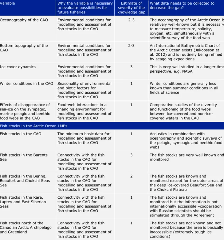
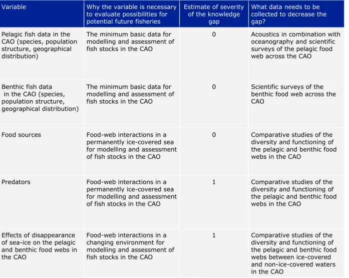
Table 2.3. Critical gap analysis for variables relevant for ecosystem analyses and climate change impacts in the CAO. Estimate of severity of the knowledge gap: 0 = no knowledge, 1 = serious lack of knowledge, 2 = insufficient knowledge, 3 = sufficient knowledge available for the purpose indicated in column 2.
Variable Why the variable is necessary to evaluate possibilities for future fisheries
Estimate of severity of the knowledge gap
What data needs to be collected to decrease the gap?
Oceanography of the CAO Environmental conditions for modelling and assessment of fish stocks in the CAO
2-3 The oceanography of the Arctic Ocean is relatively well-known but it is necessary to measure temperature, salinity, oxygen, etc. simultaneously with a scientific survey of the food web Bottom topography of the
CAO Environmental conditions for
modelling and assessment of fish stocks in the CAO
2-3 An International Bathymetric Chart of the Arctic Ocean exists (Jakobsson et al. 2012) and is routinely being refined by seagoing expeditions
Ice cover dynamics Environmental conditions for modelling and assessment of fish stocks in the CAO
3 This is very well studied in a longer time perspective, e.g. NASA
Winter conditions in the CAO Seasonality of environmental and biotic factors for
modelling and assessment of fish stocks in the CAO
1 Winter conditions are generally less known than summer conditions in all fields of science
Effects of disappearance of sea-ice on the sympagic, marine pelagic and benthic food webs in the CAO
Food-web interactions in a changing environment for modelling and assessment of fish stocks in the CAO
1 Comparative studies of the diversity and functioning of the food webs between ice-covered and non-ice- covered waters in the CAO Fish stocks in the Arctic Ocean LMEs
Fish stocks in the CAO The minimum basic data for modelling and assessment of fish stocks in the CAO
1 Acoustics in combination with
oceanography and scientific surveys of the pelagic, sympagic and benthic food webs
Fish stocks in the Barents
Sea Connectivity with the fish
stocks in the CAO for modelling and assessment of fish stocks in the CAO
3 The fish stocks are very well known and monitored
Fish stocks in the Bering, Beaufort and Chukchi Seas Sea
Connectivity with the fish stocks in the CAO for modelling and assessment of fish stocks in the CAO
2 The fish stocks are known and
monitored except for the outer areas of the deep ice-covered Beaufort Sea and the Chukchi Plateau
Fish stocks in the Kara, Laptev and East Siberian Seas
Connectivity with the fish stocks in the CAO for modelling and assessment of fish stocks in the CAO
1 The fish stocks are known and monitored but the information is not internationally accessible –cooperation with Russian scientists should be stimulated through the Agreement Fish stocks north of the
Canadian Arctic Archipelago and Greenland
Connectivity with the fish stocks in the CAO for modelling and assessment of fish stocks in the CAO
1 The fish stocks are not known and not monitored because the area is basically inaccessible (extremely tough ice conditions)