Final Report of the
Fifth Meeting of Scientific Experts on Fish Stocks in the Central Arctic Ocean
April 2018
List of Acronyms and Abbreviations ... 3
Executive summary ... 4
1 Introduction ... 5
2 ToR 1: Mapping Program ... 6
2.1 Background ... 6
2.2 Sampling areas ... 7
2.3 Field program ... 8
2.4 Prioritization of data types... 8
2.5 Vessels of opportunity ... 10
2.6 Indigenous and local knowledge ... 11
3 ToR 2: Monitoring Program ... 12
3.1 Background ... 12
3.2 Current and planned monitoring by participating states ... 13
3.3 Monitoring areas ... 13
3.4 Indicators ... 15
3.5 Prioritization of indicators ... 15
3.6 Relative availability of indicator data ... 17
3.7 Triggers ... 18
3.8 Indigenous and local knowledge ... 18
3.9 Development of methods and data assessment ... 19
4 ToR 3: Preliminary cost estimates for mapping and monitoring ... 20
4.1 Introduction ... 20
4.2 Resources related to mapping ... 20
4.3 Existing mapping efforts ... 20
4.4 Areas to map ... 20
4.5 Interpretation of cost estimates and contrasting approaches ... 21
4.6 Ice‐covered and ice‐free portions of the High Seas CAO ... 21
4.7 Regions of the High Seas CAO adjacent to the Pacific Gateway ... 23
4.8 Additional resource implications associated with the mapping and monitoring phases ... 25
4.9 Resource needs for data analysis, coordination and management associated with the mapping and monitoring phases ... 26
5 ToR 4: Data collection, sharing, and hosting protocols ... 27
5.1 Purpose ... 27
5.2 Proposed FiSCAO Data Policy and Release Guidelines ... 27
5.3 Recommended next steps ... 27
6 General conclusions ... 28
7 References ... 29
Appendix A: List of participants ... 30
Appendix B: Inventory of monitoring programs in the High Seas CAO and adjacent waters ... 31
Appendix C: Proposed FiSCAO Data Policy and Release Guidelines ... 39
AIS Automatic Identification System AUV Autonomous Underwater Vehicles AZFP Acoustic Zooplankton and Fish Profilers CAFF Conservation of Arctic Flora and Fauna CLIVAR Climate Variability and Predictability CTD Conductivity Temperature Depth DBO Distributed Biological Observatory eDNA Environmental DNA
ELOKA Exchange for Local Observations and Knowledge of the Arctic FiSCAO Scientific Experts on Fish Stocks of the Central Arctic Ocean IASC International Arctic Science Committee
ICC Inuit Circumpolar Council
ICES International Council for the Exploration of the Sea JAXA Japanese space agency
LME Large Marine Area
MOSAiC Multidisciplinary drifting Observatory for the Study of Arctic Climate NAFO Northwest Atlantic Fisheries Organization
NOAA U.S. National Oceanic and Atmospheric Administration PAME Protection of the Arctic Marine Environment
PI Principle Investigator
PICES North Pacific Marine Science Organization RDA Research Data Alliance
SAON Sustaining Arctic Observing Networks SUIT Surface and Under Ice Trawl
ToR Terms of Reference USA United States of America
WGIBAR Working Group on the Integrated Assessments of the Barents Sea
WGICA ICES/PICES/PAME Working Group on Integrated Ecosystem Assessment for the Central Arctic Ocean WMO World Meteorological Organization
This report provides a summary of the 5th meeting of scientific experts on Fish Stocks in the Central Arctic Ocean (FiSCAO) on October 24‐26, 2017, in Ottawa, Canada.
At the request of the 10 parties negotiating on an agreement to prevent unregulated commercial fishing in the High Seas portion of the Central Arctic Ocean (CAO), participants of the 5th FiSCAO meeting were tasked with addressing four Terms of Reference, summarized below:
ToR 1. Design a 1‐3 year long mapping program.
ToR 2. Design a monitoring program.
ToR 3. Identify human, financial, vessel/equipment resources needed for mapping and monitoring.
ToR 4. Develop data collection, sharing, and hosting protocols that outline the details of what and how data shall be collected, shared, and hosted for consideration by the Parties.
The 5th FiSCAO meeting included scientific representatives from seven states including Canada, the People's Republic of China, the European Union, Iceland, the Republic of Korea, the Kingdom of Norway and the United States of America. The meeting also included representatives from the International Council for the Exploration of the Sea (ICES), the North Pacific Marine Science Organization (PICES) and the Arctic Council’s Protection of the Arctic Marine Environment (PAME) and Conservation of Arctic Flora and Fauna (CAFF) working groups.
The report summarizes the elements for collecting baseline data (i.e., a mapping program) in the high seas CAO to achieve the goals of documenting species distributions, relative abundances and key ecosystem parameters (ToR 1). The mapping program describes the priority areas to sample, the types of data to collect and possible data collection approaches to employ. Participants emphasized that existing planned surveys are very limited, and that significant dedicated resources will be required to implement the mapping program.
The report outlines a strategy for monitoring indicators of fish stocks and ecosystem components (ToR 2). The report includes a list of existing monitoring programs and a prioritized list of indicators to detect environmental change in the high seas CAO. Further refinement of a monitoring program will use information from the mapping program (ToR 1). Participants emphasized the need to begin monitoring as soon as possible and that additional research is required to operationalize monitoring indicators.
The report summarizes the preliminary cost estimates (ToR 3) to implement a mapping program to collect data in the high seas portion of the CAO using a vessel of opportunity and in the Pacific Gateway region of the CAO using an independently‐organized survey. Cost implications for the monitoring program and other scientific activities are also listed (e.g., data analysis, data management).
The report includes a draft data sharing policy as the foundation for a future data sharing protocol, including the technical specifications for data sharing (ToR 4). The development of the data sharing protocol will require negotiation and legal review among the participating states. A data management and data sharing pilot study on a CAO fish database is suggested to test a framework.
Scientific experts on fish stocks in the Central Arctic Ocean (CAO) met from October 24‐26, 2017, in Ottawa, Canada to develop a scientific program supporting the participating states (Canada, the People’s Republic of China, the Kingdom of Denmark in respect of the Faroe Islands and Greenland, the European Union, Iceland, Japan, the Republic of Korea, the Kingdom of Norway, the Russian Federation and the United States of America) negotiating on an agreement to prevent unregulated commercial fishing in the High Seas portion of the CAO. The diplomatic negotiations build on the 2015 Oslo
Declaration in which the five nations with waters adjacent to the High Seas portion of the CAO agreed to interim measures for the prevention of unregulated commercial fishing in the High Seas. In November 2017, the delegations successfully concluded negotiations on the draft Agreement to Prevent
Unregulated High Seas Fisheries in the Central Arctic Ocean.
At the direction of the participating states, and building on the outcomes of four previous meetings of scientific experts on Fish Stocks of the Central Arctic Ocean (FiSCAO), participants at this 5th FiSCAO meeting were tasked with addressing four Terms of Reference (ToRs), summarized below:
ToR 1. Design a 1‐3 year long mapping program.
ToR 2. Design a monitoring program.
ToR 3. Identify human, financial, vessel/equipment resources needed for mapping and monitoring.
ToR 4. Develop data collection, sharing, and hosting protocols that outline the details of what and how data shall be collected, shared, and hosted for consideration by the Parties.
In total, 24 participants attended the 5th FiSCAO, with representation from 7 of the 10 participating states including Canada, the People's Republic of China, the European Union, Iceland, the Republic of Korea, the Kingdom of Norway and the United States of America, and representatives from the
International Council for the Exploration of the Sea (ICES), the North Pacific Marine Science Organization (PICES) and the Arctic Council’s Protection of the Arctic Marine Environment (PAME) and Conservation of Arctic Flora and Fauna (CAFF) working groups (Appendix A).
Representatives from the Inuit Circumpolar Council were not able to attend the 5th FiSCAO meeting. As a result, this report only includes limited considerations for the inclusion of indigenous and local
knowledge but this important component will be expanded in further refinements of the mapping and monitoring programs.
This report summarizes the discussions and conclusion of the 5th FiSCAO meeting in relation to each of the four ToR.
2 ToR 1: Mapping Program
2.1 Background
During the 4th FiSCAO meeting, participants drafted a schematic framework for a joint scientific research and monitoring plan program that included two survey elements, 1) a mapping phase and 2) a
monitoring phase (FiSCAO 2017). In general, the mapping phase is designed to provide a snapshot of species distributions and relative abundances in relation to biotic and abiotic factors. The mapping program can also lay the groundwork for determining population structure, trophic linkages and environmental drivers. At the conclusion of the mapping phase, if no potentially harvestable stocks are identified, efforts will focus on monitoring the High Seas CAO and adjacent areas for temporal variability or trends in species distribution or ecosystem productivity using a set of indicators.
During the 4th FiSCAO meeting, participants also created a list of detailed scientific questions that need to be addressed to fully assess the potential for sustainable commercial fishing in the High Seas CAO (FiSCAO 2017).
Of those questions, the following could be addressed during the mapping phase:
What are the distributions of species with a potential for future commercial harvests in the High Seas CAO?
What fish species are currently present in the High Seas CAO?
o What are their distribution and relative abundance patterns?
o What are their local life‐history strategies, habitat associations, and demographic patterns?
o Do these strategies, associations or patterns differ among regions in the Arctic?
What are the trophic linkages among fishes and between fishes and other taxonomic groups (i.e.
quantify food web(s))?
What are the likely key ecological linkages between potentially harvestable fish stocks of the High Seas CAO and adjacent shelf ecosystems?
o What are the connections between fish in the High Seas CAO and those in the adjacent regions?
o What are the mechanisms that establish and maintain these linkages?
For the 5th FiSCAO meeting, ToR 1 tasked participants with developing the mapping program to
document the current physical, chemical and biological oceanographic conditions and the distributions of marine invertebrates, fishes, mammals and birds in the High Seas portion of the CAO and surrounding waters (Figure 1) to determine where invertebrate or fish populations of potential commercial interest currently exist in the CAO and identify drivers of population productivity. Fishery sustainability is considered within an ecosystem context, therefore interactions between species and ecological drivers of changes in populations of harvested species are equally important as assessments of their standing stocks and life history parameters.
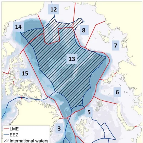
Figure 1. National boundaries (blue) and boundaries of Large Marine Areas (LMEs; red). The High Seas area (international waters) is hatched. Numbers refer to LMEs defined by red boundaries: 13 Central Arctic LME, 5 Barents Sea LME, 6 Kara Sea LME, 7 Laptev Sea LME, 8 East Siberian Sea LME, 12 Northern Bering‐ Chukchi Seas LME, 14 Beaufort Sea LME, 15 Canadian High Arctic – North Greenland LME, 3 Greenland Sea LME (northern portion only). Source: FiSCAO 2017.
2.2 Sampling areas
The High Seas CAO covers 2.8 million km2, and given that sampling periods and resources will be limited, subareas of the High Seas CAO will need to be prioritized for sampling. Areas of particular interest for the mapping program can be identified based on the relative availability (or lack) of information, degree of sea ice loss and water depth. Areas in the High Seas CAO with little existing information, the greatest degree of sea ice loss, and where depths are fishable (e.g., less than 2000 m for demersal species), such as the East Siberian Sea including the Chukchi Borderlands and waters northwest of Wrangel Island, are of particular interest for demersal species. There is virtually no knowledge about the existence and distribution of pelagic fishes in the deep‐sea areas of the CAO, e.g., redfish Sebastes spp., lanternfishes (myctophidae) and polar cod Boreogadus saida. Filling this knowledge gap sets an important baseline for future management of fisheries and associated ecosystem impacts in the CAO. Gaining the best possible knowledge about the presence and distribution of pelagic fishes in the CAO is therefore considered a priority of the mapping program. Surveys should also be conducted in areas where there have been documented, observed or expected northward range expansions by potentially harvestable species (for a list of potential species, see FiSCAO 2017). Surveys should also include areas where environmental changes have been documented or are expected to occur. Refuge areas for polar fishes from climate
change effects, both physical and biological, within which species can complete their lifecycles are of particular ecological importance (e.g., ice‐covered CAO for Boreogadus saida). Additional research beyond the scope of the mapping program is required to identify areas within which individual polar fishes can complete their life cycles to identify candidate refuge areas.
2.3 Field program
The mapping program should occur over as short a time period as possible (i.e., within 1‐3 years) to capture the current state of the High Seas CAO ecosystem, adjacent ecosystems and potential commercial species therein. To the extent possible, this program should make use of existing surveys and monitoring programs in territorial waters or the High Seas CAO, vessels of opportunity and indigenous and local knowledge. Synoptic mapping surveys should be conducted over as much of the High Seas CAO as possible.
The mapping program will require collection of a wide suite of data and multiple vessels to complete.
Sets of vessels will undertake mapping in different regions of the High Seas CAO (see section 2.2 Sampling areas). All participating countries should contribute vessels, with vessels tasked in waters nearest to their homeport, to the extent possible. All vessels will follow standardized sampling protocols and use consistent data formats; internationally agreed best‐practices will be followed, when available.
Sampling will occur in sympagic, pelagic and benthic habitats to fully characterise the communities and environmental conditions throughout the water column, particularly in areas that have never been surveyed before. Vessel‐based sampling should occur when the sea ice extent is at its lowest, allowing the largest possible area to be surveyed, with a primary focus on fish sampling.
The resulting mapping data will be suitable for identifying species distributions and relative abundance patterns. The timeframe will not be long enough to generate estimates of total abundance or
replacement rates. The mapping program will focus on capturing spatial variability in populations and, if sufficient resources are available and the program includes multiple years of sampling, it may be
possible to capture temporal variability through repeated sampling of a subset of stations within and across years.
Target survey locations may contain sensitive benthic habitats or species (e.g., corals and sponges). To minimize the impact of scientific surveys on these habitats and species, to the extent possible, sampling locations for bottom trawls and other bottom contacting gears should be visually surveyed using Autonomous Underwater Vehicles (AUV) or drop cameras prior to gear deployment. If sensitive benthic habitats or species are observed, the sampling location will be moved to an adjacent area.
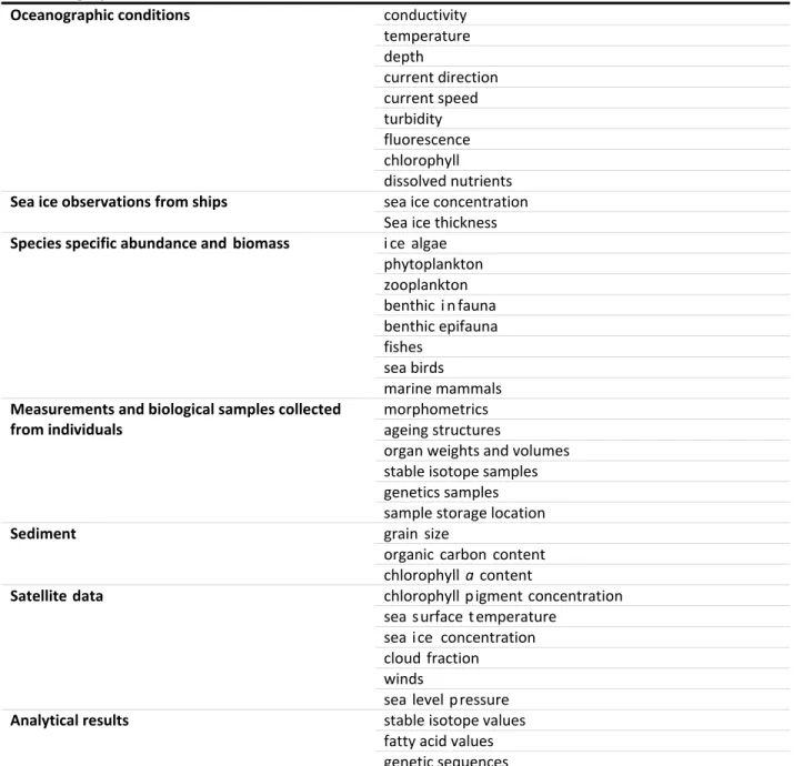
2.4 Prioritization of data types
To achieve the fundamental goals of the mapping program, to document species distributions, relative abundances and key ecosystem parameters, certain data are essential. Additional data could be collected at minimal costs to provide complete fundamental datasets for fishery monitoring and assessment programs.
Three data tiers were identified as follows:
Data essential for identifying fish species distributions and relative abundances include the following:
Information on the vessel, gear and fishing practices that affect fishing effort (i.e., fishing gear specifications, fishing effort metrics (e.g., length of time fishing, speed of fishing), fishing vessel details (e.g., vessel size, horse power, IMO number), net mensuration). These data are required to have confidence that the sampling methods were appropriate and the data are reliable for the mapping goals.
To document and analyse patterns in species distributions and relative abundances, data need to be recorded regarding the date, latitude, longitude, fishing depth and water column depth for each sampling event, as well as species binomials (scientific name) and total number and total weight for each species captured or acoustic data (target strength converted to biomass) collected during the sampling.
Data essential for understanding population structure and the factors affecting species distributions and productivity include:
Characteristics of individual fishes (i.e., length, weight, age, sex and maturity) and habitat conditions (i.e., temperature and salinity profiles, substrate type and composition, sea ice concentration and nutrient concentrations).
For acoustic surveys, net collection or video observations of acoustic targets is critically important.
Data needed to manage fisheries in an ecosystem context include:
Trophic dynamics (i.e., phytoplankton abundance and composition, zooplankton abundance and composition, marine mammals, sea birds, lipid content, stable isotope composition, fatty acid contents, stomach contents and community composition).
Data on animal health (i.e., condition, growth via examination of RNA/DNA), CO2‐carbonate‐
alkalinity, O2, currents and light levels would provide insights into drivers of fish productivity and stressors.
Genetic sequencing data are important for assessing stock structure and connectivity.
Understanding the relative contributions of local reproduction and immigration to the maintenance of fish stocks in the High Seas CAO is particularly important when considering potential commercial fisheries.
Environmental DNA (eDNA) provides an alternative method for assessing species presence and may identify species not available to fishing gears.
Assessments of catchability (e.g., trawl cameras to observe escapement) are important for integrating catch data across surveys.
2.5 Vessels of opportunity
Vessels and other platforms of opportunity should be used to the extent possible to supplement data collected by the dedicated mapping program. Several types of platforms of opportunity exist, including:
Planned scientific missions (e.g., Multidisciplinary drifting Observatory for the Study of Arctic Climate (MOSAiC)) and supply ships supporting the mission
Icebreakers on other missions
Passenger cruise ships
Satellites (e.g., Japanese satellite by Japanese space agency (JAXA), launched December 2017)
Ice camps (e.g., Russia North Pole ice camp)
Critter cams and electronic animal tagging programs
Gliders
Submarines
Additional vessels of opportunity can be identified by contacting the shipping industry, examining Automatic Identification System (AIS) data from previous years and consulting regulatory authorities.
Within the next 5 years (i.e., until 2023) the following research icebreakers will potentially be operating in the CAO. The coordinators of these vessels should be contacted to verify the likelihood that they will be operating in the CAO and to evaluate the possibility of using the ship as a vessel of opportunity.
Polarstern (Germany; MOSAiC project) Xuelong (China)
Support vessels for the MOSAiC project Arctica (Finland)
Oden (Sweden) Araon (Korea)
Kronprins Haakon (Norway) Russian icebreakers
Research programs operating on icebreakers should be asked to collect as much of the following data as possible. Within the list, data types identified as “direct observations” have the greatest potential for giving information to address the objectives of the mapping program.
Passive data collection:
o Sonar profile data for fish (direct observations)
o Soundings giving bathymetric information (some level of benthic habitat characterization)
o Acoustic Doppler Current Profiler (ADCP)
Active data collection:
o Marine mammals/bird observers o Conductivity Temperature Depth (CTD) o Rosette
o Fluorescence, chlorophyll a
o Drop cameras – fish focused protocols (direct observations) o Plankton tows including ichthyoplankton (direct observations) o Environmental DNA (eDNA; direct)
o Fish sampling including various types of methods (direct observations)
2.6 Indigenous and local knowledge
Historic and contemporary baseline data on species distributions and abundances, and environmental conditions in waters adjacent to the High Seas CAO, and to a lesser extent within the High Seas CAO, may be available through indigenous and local knowledge holders. The Inuit Circumpolar Council will be consulted and sources of information may include existing regional programs such as the Nunavut Coastal Resource Inventory in Nunavut, Canada. Participation by Indigenous knowledge holders will be important to the success of this effort, and participants recommended continued engagement and continued development of the mapping and monitoring programs with Indigenous representation.
3 ToR 2: Monitoring Program
3.1 Background
For the 5th FiSCAO meeting, ToR 2 tasked the participants to design the monitoring program. This included the identification and definition of potential areas for monitoring and appropriate indicators to measure. The design of the monitoring program is to make use of existing programs to the extent possible, including government, community‐based and academic programs as well as indigenous and local knowledge. Participants agreed the best approach was to begin by developing a monitoring
strategy that would inform future refinement of the monitoring program. Recommending a strategy was determined to be more valuable than developing a program until available resources are committed by the participating states. Additionally, the identification of indicators and selection of triggers will likely depend on what is learned during the mapping phase.
The monitoring strategy was developed with the assumption that the FiSCAO monitoring program would primarily rely on existing monitoring activities. Participants also recognized that new research programs are being or may be developed by various governments, academic or industrial bodies, and the FiSCAO monitoring program could leverage these new activities. Where possible, advice on the type of data collected should be given to existing and developing monitoring programs to improve alignment with the FiSCAO monitoring program.
Resources will be required for both data collection and data analysis. Although this monitoring strategy was developed to leverage existing monitoring programs, any requirements for new monitoring activities in the High Seas CAO or in waters adjacent to the High Seas CAO would significantly increase resources requirements. For data analysis, various options are possible, including forming a new working group or leveraging existing analytical groups that are conducting relevant assessments (e.g., the
ICES/PICES/PAME Working Group on Integrated Ecosystem Assessment for the Central Arctic Ocean (WGICA)).
Although the mapping phase will generally be followed by monitoring, there is a strong need to begin collecting monitoring data immediately. The collection of time series data is essential for ecosystem‐
based management of fisheries. Therefore, it is essential that monitoring begin well in advance of the start of any potential commercial fishing in the High Seas CAO, in part to provide a baseline against which any changes observed can be interpreted. Participants also noted that seasonal aspects in the High Seas CAO and adjacent waters are not well documented and that information collected outside the open water months would be highly valuable.
The monitoring strategy presented in this report includes an inventory of existing monitoring programs maintained by the participating states or bodies, a prioritized list of geographical areas for implementing a monitoring program and a list of potential indicators to monitor. In addition, this monitoring strategy includes considerations for identifying triggers that would indicate that or where a change in
productivity has occurred, at least within a localised area, and when a new targeted survey should be conducted (i.e., repeat the mapping phase in a localized area).
3.2 Current and planned monitoring by participating states
Prior to the 5th FiSCAO meeting, participants provided metadata on existing activities that could support a monitoring program for the High Seas CAO to develop an inventory of monitoring programs (Appendix B). The inventory includes programs that take (or plan to take) regularly scheduled observations in the High Seas CAO, adjacent and contiguous Larger Marine Ecosystems (LMEs) or the four major gateways to the Arctic (i.e., Bering Strait, Fram Strait, the Barents Sea and the Canadian Arctic Archipelago).
The intent was to create a preliminary list of the existing programs that might provide information relevant to the FiSCAO monitoring program. Given the ecosystem‐based approach of the FiSCAO research program, the inventory includes programs that collect data on oceanographic conditions, productivity, invertebrates, fishes, marine mammals and birds to assess fish populations, their drivers and other species that could be affected by commercial fishing.
The resulting inventory is not exhaustive and is biased towards fisheries survey programs relative to other types of surveys (e.g., physical and biological oceanography, marine mammals, and seabirds). The monitoring programs in the inventory are primarily undertaken by governments, but monitoring programs by academia or other organizations may also be relevant and should be considered.
The inventory includes information from 8 countries including Canada, China, Germany, Greenland (Denmark), Iceland, Korea, Norway and the USA. During breakout sessions, the participants identified the main types of monitoring programs included in the inventory.
The main types of monitoring programs are:
Fish and/or invertebrate surveys
Ecosystem surveys (biological components with oceanographic and environmental data)
Physical oceanographic surveys
Moorings and ice buoys (physical, chemical, geological and biological data collection)
Marine mammal surveys/satellite tagging
Seabird surveys/satellite tagging
Remote sensing
The inventory also identifies various levels of data availability for the different programs. Some
programs reported that data are publically available with access through an online data repository while data from other programs can only be found in published reports or by request. Data sharing is further discussed as part of ToR 4.
3.3 Monitoring areas
Three geographical subareas were identified as priorities for the monitoring program; the High Seas CAO, the Atlantic gateway and the Pacific gateway. For the purpose of this monitoring strategy, the Atlantic gateway includes the Barents Sea LME and the northern portion of the Greenland Sea LME. The Pacific gateway encompasses Bering Strait and the northern Bering‐Chukchi Seas LME, excluding the High Seas CAO (Figure 1). A fourth generalized subarea was included as the other waters adjacent to the
High Seas CAO that are under the jurisdictions of states, to capture areas that are not covered by the gateways. Further refinement of the geographic areas will be dependent on the outcomes of the mapping program.
The joint monitoring program would greatly benefit from data collection in the High Seas CAO; however, because few programs exist in the High Seas CAO, data regularly collected from both the Atlantic and Pacific gateways were identified as critical for detecting potential changes in the High Seas CAO. Other waters adjacent to the High Seas CAO and under the jurisdictions of states were also seen as important to include in a monitoring program.
The Atlantic and Pacific gateways were recognised as priority subareas to monitor because of their strong influences on the Arctic Ocean through the transport of water, heat, nutrients and plankton from subarctic to Arctic waters. Both gateways may also be important conduits for fish movement and northward distributional shifts. Due to the importance of the gateways, monitoring activities are already well established and assessments are conducted regularly.
Key aspects of the four geographic subareas include:
High Seas CAO
o Overall, very limited monitoring occurs in the High Seas CAO.
o Fish survey data suitable for monitoring are not available in the High Seas CAO. New resources would be required to fill this gap, e.g., using autonomous sonars connected to sea‐ice buoys.
o Limited acoustic data have been collected to examine fish presence and distributions.
Through vessels of opportunity, new acoustic data could be collected and, where possible, advice should be given for the methodology (ideally the data would include sampling fish to support acoustic data).
o Some aspects of the CAO ecosystem can be monitored using satellite data, vessels of opportunity and marine mammal/seabird surveys and remote tracking data.
o Analyses of these data could be potentially conducted by the WGICA (or a similar body), if added to their terms of reference.
Atlantic gateway (Barents Sea LME and the northern portion of the Greenland Sea LME)
o Due to the increasing influx of Atlantic water into the area this is considered a region where species extensions into the CAO are likely to occur as environmental conditions change.
o The Atlantic gateway is already being monitored for changes and assessed by ICES working groups and by monitoring programs, such as the Barents Sea Ecosystem Survey (Norway, Russia) and the Hausgarten LTER (Germany).
Pacific gateway (Northern Bering‐ Chukchi Seas LME)
o Some species in the Pacific gateway will expand northward to the CAO as environmental conditions change.
Parts of the Pacific gateway is monitored for changes and assessed by management agencies (e.g., NOAA conducts regular stock assessments and other work in portions of the Bering Sea).
Other waters under the jurisdictions of states
o Data from existing monitoring programs should be included and can contribute relevant information.
o Indigenous and local knowledge from coastal communities in these subareas can contribute valuable information.
3.4 Indicators
In the context of the FiSCAO monitoring program, indicators are quantitative variables that can be used to detect changes (e.g., increases) in the availability and viability of species of commercial interest in the High Seas CAO and ecosystem state. Indicators can include both direct measures of fish and
invertebrates and indirect ecosystem variables (e.g., physical, biological) of fish and ecosystem productivity.
A prioritized list of potential indicators that could be used in a monitoring program to detect changes in fish stocks of the High Seas CAO is included below. The indicators were also selected based on the types and availability of measurements collected by existing monitoring programs. Priority was determined based on the usefulness of the indicator for providing information on changes to fish species presence, productivity or distribution.
Although monitoring should continue in parallel with the mapping phase, a more refined set of
indicators will need to be developed based on data collected during the mapping phase. In addition, the extent of monitoring may be scaled according to what is found during the mapping phase. For example, if significant abundances of a fish species of potential commercial interest is discovered in the High Seas CAO, dedicated data collection for stock assessment purposes will be required. Conversely, if the presence/relative abundances of fishes do not suggest potential commercial interest, a minimal monitoring program could be implemented based upon continued environmental monitoring and infrequent fish surveys.
Further research will be required to allow quantitative comparisons and assessments of indicators and to operationalize scientifically sound monitoring indicators. Also, when operationalizing the monitoring program, examinations of individual indicators in isolation have limited value; inferences about the status of fish stocks in the High Seas CAO should only be made based on a combination of indicators.
3.5 Prioritization of indicators
1. Distributions of potential commercial fishes and invertebrates.
a. Northward expansion of the distribution range of commercial fishes and invertebrate species would give a direct measure of changes.
b. Observations can focus on existing lists of species that have the potential to move northward into the Arctic Ocean and into the High Seas CAO.
c. A list of target species can be developed from the following select sources:
i. Primary literature: Hollowed et al. 2013; Fossheim et al. 2015; Ingvaldsen et al.
2015; Frainer et al. 2017; Haug et al. 2017; Mueter et al. 2017.
ii. FiSCAO 2017 ‐ Appendix B of the 4th FiSCAO report includes a list of fish and invertebrate species reported in the literature in the High Seas CAO and in adjacent waters with potential for future commercial harvests.
2. Fishing vessel activity in waters adjacent to the High Seas CAO.
a. Expansion of existing fisheries as indicated by fishing vessel activities towards waters adjacent to the High Seas CAO. This would be indicative of resource movement.
b. Data could be sourced from AIS.
3. Marine mammal and seabird abundance, distributions, diets, condition or foraging behaviours.
a. Changes in fish and ecosystem productivity can be inferred from changes in predators such as marine mammals and seabirds. Several types of observations and
measurements can provide useful information (e.g., foraging behaviour based on satellite‐tagging data, monitoring of population parameters in select breeding colonies).
b. For some species, long time series exist (e.g. several decades) and observations are likely to be ongoing.
c. Information sources include existing regional research groups and inter‐governmental observation networks (e.g. the North Atlantic Marine Mammal Commission).
4. Zooplankton transport and potential establishment into the High Seas CAO.
a. Changes in the distribution of zooplankton can be an indicator of changes in the
ecosystem and food web structure. Additionally, detection of ichthyoplankton (eggs and larvae of fish) provides direct observation of potential changes in fish populations.
5. Deep scattering layer.
a. Acoustics surveys can be used to estimate fish and invertebrate presence, distribution and relative abundance. This data source is an indirect measure of fishes or
invertebrates and requires direct observations (e.g. using trawls or cameras) to identify species.
6. Primary productivity and associated variables.
a. Primary productivity can be used to detect changes in the lower food web and may indicate changes in productivity of fishes and invertebrates and other ecosystem components.
b. Relevant measures and analyses by existing monitoring programs include:
i. Primary production in sea ice and water.
ii. Nutrient concentrations.
iii. Chlorophyll‐a concentrations in sea ice and water (by field measurements or satellite images).
iv. Phytoplankton community composition.
7. Sea ice.
a. Changes in sea ice extent (volume), thickness and other parameters (e.g., age of sea ice) will affect marine ecosystems.
b. Changes in sea ice may affect ecosystem components such as primary producers and potentially result in altered food webs. In addition, fish species may be directly affected by changes in sea ice (e.g., sea ice importance as feeding and spawning habitat).
c. Sea ice can be monitored by direct observations and by remote sensing (e.g., satellite).
8. Currents in the gateways.
a. Changes to fluxes and water masses northward through the Atlantic and Pacific gateways may be linked to species range expansions either by affecting environmental conditions or by entrainment of individuals.
b. Moorings in various locations in the gateways can monitor changes in currents.
9. Temperature.
a. Water temperature is an important driver of ecosystem processes. Additionally, changes in water temperature can be used to infer changes in fish and invertebrate distributions based on species‐specific thermal tolerances.
b. Water temperature can be measured by:
i. Deployed instruments, such as CTDs.
ii. Moorings with temperature sensors.
iii. Satellite‐based estimates of surface water temperature.
10. Ocean acidification.
a. Increasing levels of ocean acidification may lead to adverse effects in food webs.
b. Linkages between ocean acidification and impacts to fishes and invertebrates are not fully understood and ocean acidification is not routinely measured across monitoring programs.
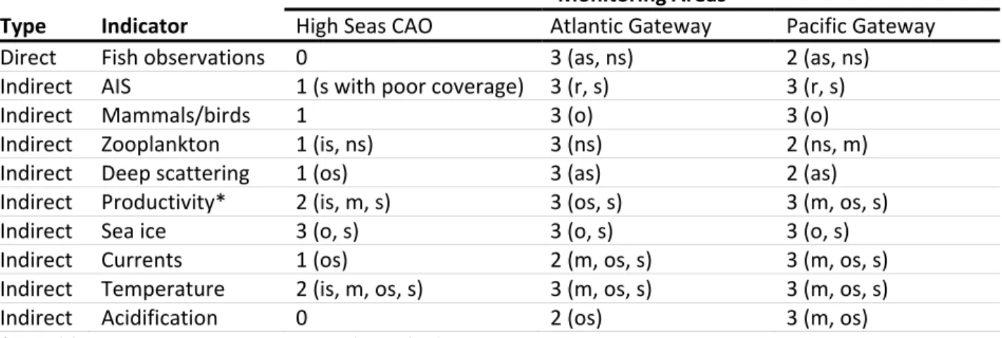
3.6 Relative availability of indicator data
Participants assessed the availability of the listed indicators in each of the three priority subareas, the High Seas CAO, the Atlantic gateway and the Pacific gateway. Based on the knowledge of meeting participants, scores were assigned for the present relative sampling intensity/frequency of each indicator variable for each subarea (Table 1). The method of data collection was also noted. This exercise was undertaken to determine if the subareas were well represented for the listed indicators and to identify data gaps. It should be cautioned that high scores for indicators in the gateways do not necessarily mean that existing data collections are sufficient. These high scores must be taken in context with the relatively low survey coverage reported for the High Seas CAO.
Overall, survey coverage was found to be highest in the gateways relative to the High Seas CAO. In the High Seas CAO, data collection generally does not occur or is very infrequent, especially for biological and ecosystem variables (e.g., marine mammals, zooplankton). In the Atlantic and Pacific gateways there is moderate to good coverage of fish surveys. In the gateways, ecosystem variables are surveyed with moderate to good coverage; however, the Pacific gateway has relatively less coverage for marine mammal observations and zooplankton. In both gateways, physical variables have moderate to good coverage and are measured by moorings, satellites and oceanographic surveys.
Table 1. Relative assessment of survey coverage of indicator variables within each monitoring subarea. 0=no ongoing sampling; 1=poor; 2=moderate; 3=good. Methods of data collection are included in brackets next to each score: as = acoustic surveys; is = ice stations; ns = net surveys; m = moorings; o = observers; os = oceanographic surveys; r = radio; s = satellite.
Monitoring Areas
Type Indicator High Seas CAO Atlantic Gateway Pacific Gateway
Direct Fish observations 0 3 (as, ns) 2 (as, ns)
Indirect AIS 1 (s with poor coverage) 3 (r, s) 3 (r, s)
Indirect Mammals/birds 1 3 (o) 3 (o)
Indirect Zooplankton 1 (is, ns) 3 (ns) 2 (ns, m)
Indirect Deep scattering 1 (os) 3 (as) 2 (as)
Indirect Productivity* 2 (is, m, s) 3 (os, s) 3 (m, os, s)
Indirect Sea ice 3 (o, s) 3 (o, s) 3 (o, s)
Indirect Currents 1 (os) 2 (m, os, s) 3 (m, os, s)
Indirect Temperature 2 (is, m, os, s) 3 (m, os, s) 3 (m, os, s)
Indirect Acidification 0 2 (os) 3 (m, os)
*PP, Chl‐a, nutrient concentrations, phytoplankton
3.7 Triggers
A trigger refers to the value (relative or absolute) of an indicator that would suggest a potential change has occurred in the availability of fish and invertebrate stocks or in ecosystem productivity in the High Seas CAO. Triggers would be used to determine when to repeat the mapping phase or to re‐sample select areas. As noted above, indicators should not be evaluated in isolation but in combination with other indicators.
For the selection of appropriate triggers, participants emphasized the need for greater understanding of the sensitivity of indicators and their relationships with fish and invertebrate stocks. Information
gathered during the mapping phase would be used to develop appropriate triggers, and additional research will probably be necessary. For example, additional work is required to understand natural variability in order to select trigger values. Similar to discussions during the 4th FiSCAO meeting,
participants suggested that a working group of scientists would be needed to set appropriate threshold values for the indicators.
3.8 Indigenous and local knowledge
Indigenous and local knowledge is a valuable source of information for understanding and monitoring changes in Arctic fisheries. During the monitoring phase, it is expected that indigenous and local knowledge, particularly from coastal communities in regions adjacent to the High Seas CAO would greatly enhance an ecosystem‐based understanding of potential changes. The amount of Indigenous and local knowledge that has been directly collected in the High Seas CAO is likely to be minimal given the significant distance between High Seas waters and communities.
Participation by Indigenous knowledge holders will be important, and participants recommended continued engagement and continued development of monitoring programs with Indigenous Peoples.
This important element of the monitoring program is expected to be expanded during its further
development. In addition, existing organizations or programs were identified that may contribute relevant information including: the Inuit Circumpolar Council (ICC); the Exchange for Local Observations and Knowledge of the Arctic (ELOKA); and the Alaska Native Organizations that work cooperatively with U.S. federal government agencies through Marine Mammal Protection Act cooperative agreements (e.g., Alaska Eskimo Whaling Commission, Eskimo Walrus Commission).
3.9 Development of methods and data assessment
Detailed methods and data assessment techniques need to be developed. Several options for the data assessment were suggested, including the option of leveraging activities by other analytical groups, such as the Working Group on the Integrated Assessments of the Barents Sea (WGIBAR). However, it was noted that other analytical groups may not use metrics that are most relevant to address the objectives of the FiSCAO monitoring program. An alternative option is to create a new working group supported by all participating states.
A working group of scientists could undertake further refinement of indicators and develop appropriate triggers, develop methods and perform assessments. The following are potential items that may be considered by a working group:
Define key areas where potential changes are anticipated in commercial fish and invertebrate species (e.g. Chukchi borderlands, Russian shelves).
Determine appropriate methods for data collection and what data to request from surveys including considerations for:
o Sampling locations.
o Fishing gear.
Determine appropriate data analyses including considerations for:
o Analyses using multivariate indices to combine information from multiple survey sources.
o Region‐level analyses of all surveys instead of survey‐level analyses.
o Statistical techniques to identify changes in the distribution of a species and changes in the geographic centre of a species (e.g., FishStat; ICES FishDish workshop).
o Statistical techniques to detect regime changes.
Improve understanding of inter‐relationships between indicators and fish/invertebrate species and ecosystems including considerations for:
o Examining how fish distribution may change with temperature and sea ice.
o Identifying limiting oceanographic factors (including nutrients) for production.
o Evaluating ocean acidification as an indicator.
o Determine or develop means of understanding how much primary production would be required in the High Seas CAO to support higher fish productivity.
Determining appropriate triggers including considerations for:
o Assessing multiple years of data (>5 years) to understand the influence of inter‐annual variability, which is necessary to set appropriate values for triggers.
o Determining appropriate timeframes for change.
4 ToR 3: Preliminary cost estimates for mapping and monitoring
4.1 Introduction
ToR 3 called for the identification of resource needs (human, vessel and equipment) for the mapping and monitoring components of the joint scientific research and monitoring plan. In this section of the report, the goals of mapping and monitoring are briefly reviewed and example budgets based on participants’ experience with similar programs in the Pacific Gateway and in the High Seas CAO are provided.
4.2 Resources related to mapping
Baseline information, especially on fish populations, is lacking for many parts of the CAO and most notably for the High Seas region, hence a substantial mapping effort is initially required. Here, mapping refers to the initial data collection and analysis in the area with the aim of creating an initial snapshot of the system to assess what species reside in the High Seas CAO, their spatial variability, and their relative abundance. A synoptic mapping survey should be carried out, covering as much of the High Seas CAO as possible in order to characterize fish and invertebrate communities and their spatial variability.
Ideally, the initial mapping phase should consist of ecosystem‐based synoptic surveys that sample as much of the High Seas CAO (2.8 million km2) as possible. These surveys should characterize the presence of demersal and shellfish stocks in the region but should also collect ecosystem related information consistent with three data tiers described under ToR 1. In addition to sampling fish resources, data collection should include oceanographic observations, primary production measurements, zooplankton abundance and species composition, seabird and marine mammal observations, etc. that will
collectively help identify environmental drivers, food‐web interactions, and key ecosystem linkages.
4.3 Existing mapping efforts
The 10 participating states in the Arctic fisheries negotiations have conducted relevant Arctic research for at least the past six decades, as was described in presentations from the 3rd FiSCAO meeting. A variety of physical and biological observations relevant to mapping have been taken recently from a variety of platforms (ships, moorings, AUVs, remote sensing) in the High Seas CAO and adjacent areas.
4.4 Areas to map
To achieve the goals of the mapping program, three general regions of the CAO were identified because of the different resources and platforms that will be needed to accomplish the goals of the program:
Ice‐covered and ice‐free zones of the High Seas CAO.
Ice‐covered and ice‐free zones of the High Seas CAO adjacent to the Pacific Gateway.
Ice‐free zones of the High Seas CAO adjacent to the Atlantic gateway.
Costing case studies were developed for the first two regions to provide contrasts between the resources and costs associated with surveying an area using a vessel of opportunity or a dedicated vessel, and between surveying ice‐covered and ice‐free zones. Because of the vastly different resources and approaches needed to sample in ice‐covered High Seas areas compared to the Pacific Gateway region, the resources required for each area are treated separately below. In addition, research in the
High Seas CAO and in the High Seas CAO adjacent to the Pacific Gateway would generate significant amounts of data that will require data management, analysis and storage; accordingly, resource needs for those activities are combined (see section 4.9 Resource needs for data analysis, coordination and management associated with the mapping and monitoring phases).
4.5 Interpretation of cost estimates and contrasting approaches
Caution should be applied when reviewing the preliminary cost estimates provided in this document.
The cost estimates provided for work in the High Seas CAO rely on accessing a vessel of opportunity with additional support from a supply vessel that will be undertaking a research project in the High Seas CAO in 2019‐2020 (i.e., Germany’s MOSAiC project using the RV Polarstern icebreaker and resupply vessels).
In contrast, the cost estimates provided for working in the High Seas CAO adjacent to the Pacific
Gateway do not leverage a planned research project and therefore reflect the full costs of undertaking a mapping survey.
There are also significant differences in the type of research and data that can be generated by the two approaches. Work on vessels of opportunity must balance the priorities of multiple partners and the research capabilities can be limited to the vessel design, number of project‐dedicated staff onboard and access and operability of gear and equipment. For the mapping program in the High Seas CAO, using a vessel of opportunity such as the RV Polarstern will provide limited coverage relative to the large area of the High Seas CAO (2.8 million km2). Independently organized surveys have fewer competing priorities to address, can generally cover a larger area and can plan to include the use of more appropriate vessels and gear for fish and ecosystem research. However, independently organized surveys are challenged by limited availability of appropriate vessels and significantly higher resource costs.
4.6 Ice‐covered and ice‐free portions of the High Seas CAO
Large parts of the High Seas CAO are presently ice‐covered year‐round. It is therefore necessary to use research icebreakers equipped with fish echosounders and pelagic trawls. The backbone of the sampling will be hydroacoustic profiles of the water column, with pelagic fish detected based on their acoustic signatures and subsequent estimation of biomass. This sampling will be complemented by under‐ice trawling for species such as Boreogadus saida, pelagic target trawls to calibrate hydroacoustic targets where possible, and the collection of physical and ecosystem parameters, such as temperature and salinity profiles, algal biomass in sea ice and water column, and zooplankton abundance.
Constraints:
Since there are no regular survey programs in the High Seas CAO, vessels of opportunity must be used out of the very limited pool of icebreaking vessels suitable to fulfill this task.
Due to the widespread ice coverage, sampling with conventional fishing gear is logistically challenging. Development of suitable ice‐adapted gear to sample fish in the ice‐covered oceans may therefore be necessary.
The entirety of the CAO cannot be covered by a single survey because of the vast area (2.8 million km2 – larger than the Mediterranean). To significantly extend the spatial and seasonal coverage of the mapping program, Acoustic Zooplankton and Fish Profilers (AZFP) equipped to
autonomously collect and transmit hydroacoustic data would need to be deployed in combination with autonomous bio‐physical sea ice observatories on free drifting ice floes.
4.6.1 Focus area and timing of a limited survey in the High Seas CAO by MOSAIC
The target area of the mapping survey is the High Seas CAO, an area mostly situated in deep‐sea waters north of 80°N. The survey should be conducted as soon as possible, i.e., in the next 2‐3 years.
Information about seasonal changes in fish distributions is desirable. The international year‐long drift expedition MOSAiC with the RV Polarstern in 2019‐2020 would serve as an excellent and cost‐effective basis for a limited mapping survey. Since trawling cannot be conducted during MOSAiC, data collection should be supplemented with a trawl survey using one of the supply vessels visiting the RV Polarstern, e.g., RV Oden. Alternatively, an independently‐organised mapping survey in the CAO using a ship of opportunity cannot realistically be achieved before 2020 and to obtain a comparable level of mapping for the high Seas CAO as outlined for the High Seas CAO adjacent to the Pacific Gateway (see below), substantial higher resources than outlined in Table 2 would be needed.
Table 2. Estimated resources ($K USD) needed for a survey in the High Seas CAO in conjunction with MOSAIC.
Trawl survey MOSAiC
Number of berths
Fish 3 1
Ecosystem 1 ‐
Physical 1 ‐
Total 5 1
Time requirement (days)
Fish 3 180*
Ecosystem 1 ‐
Physical 1 ‐
Transit 15 ‐
Total survey duration 20 180
Salaries costs
~3 FTEs estimated at $112K/year 224 112
Total salaries 224 112
Equipment and logistics costs
Surface and Under‐Ice Trawl (SUIT) 178 ‐
Logistical costs and consumables 12 12
Field equipment (pelagic trawl, AZFP, sensors, sampling tools) 107 487
Berth fee 178 320
Development of ice‐suitable sampling gear 178 ‐
Travel costs 14 18
Total equipment and logistics costs 667 837
Total trawl survey including salaries 891 949
Total survey ($K USD) 1840
*Assuming a commitment to 6 of the 12 months of the drift project
4.7 Regions of the High Seas CAO adjacent to the Pacific Gateway
Sampling in ice‐free zones should follow methods currently used by many fisheries oceanography surveys. Intensive sampling efforts can effectively sample data from all three data tiers identified in ToR1. Once resources and sampling capabilities are identified, sampling effort can be spread across the prioritized regions of the Pacific Gateway either through a systematic grid design, random sampling or mutually agreed upon “hotspot” stations similar to the Distributed Biological Observatory (DBO)
approach. Regardless of the design used, instituting a sampling regime that effectively samples the three data tiers will need to be integrated at the station level and requires extensive sampling effort. Time required to accomplish these goals will likely reduce the number of stations to very low numbers, likely 2‐3 stations per day. Considering the short window of sampling time and vessel endurance, this may require extensive prioritization of sampling effort in the ice‐free zones.
For sampling in ice‐covered zones, it is likely that much of this effort would occur on vessels of opportunity. Most of these vessels are used primarily for geophysical research and therefore are not configured for deploying common types of fishing gear. Adapting fishing methods such as trawling and longlining for use from icebreaker platforms would require development of innovative technologies to achieve these types of sampling. Determining a sampling design may be difficult if the research cruise has competing objectives. Due to issues such as the on deck foot print of sampling gear, and the total length of time required to deploy, fish and retrieve fishing gear, the use of gears such as under ice trawls (i.e., Surface and Under Ice Trawl (SUIT)) will likely need to receive top priority. Preferred sampling methods would need to compliment and not impede other cruise objectives. Alternatives such as longline deployment may accomplish this balance because setting and retrieval are relatively quick and the gear can actively sample while other cruise sampling objectives are being carried out.
4.7.1 Resources required for the high seas CAO adjacent to the Pacific Gateway
Sampling platforms are likely the most significant resources required. In the ice‐free zones, vessel charter costs will be significant, as most vessels capable of operating in these regions will have high daily operating costs. Vessel size will likely be >200 ft and vessels will likely have an operational endurance of over 45 days, be able to deploy multiple scientific sampling gear types, and carry a minimum of 15 people. Fuel costs will be high as transit time from deep water ports must be included in all survey estimates. Additionally, operating in the High Seas CAO may limit the available vessels as many licenses are issued by countries and some vessels and captains may not be licensed to operate in international waters.
For operations in ice‐covered zones, vessel costs can be extreme and exceed $50,000 (USD)/day, and markets for suitable vessels is limited. Because of these constraints, and due to limitations on funding, survey operations may need to be conducted on vessels of opportunity and on scientific survey vessels that are designated for multiple sampling objectives. Under these scenarios, it is likely the number of scientists onboard that are dedicated to fish surveys may be reduced due to other mission interests and vessel capabilities. If the mission is dedicated to fishing, it is likely that up to 15 scientists would be needed to collect the full suite of fish and ancillary biological and abiotic data identified in ToR 1.
Seasonal timing is important and surveys will need to be conducted in summer months, but because ice‐
capable vessels are being used, the sampling timeframe may be slightly greater compared to work done in ice‐free zones. As was noted above, sampling gear will need to be modified from commercially available sources or newly developed through research efforts to effectively sample from ice‐capable vessel platforms. Equipment costs in ice‐covered zones are likely to be much higher than for research cruises in ice‐free zones where traditional sampling gear can be used.
4.7.2 Focus area and timing of survey of the high seas CAO adjacent to the Pacific Gateway Shallow areas in and near the Pacific Gateway are expected be more biologically productive than deeper waters. Therefore, increased sampling effort in shallower depths where fish resources and fishing activities may occur should be prioritized. Focusing on depths less than 1500 m provides a general guide for choosing survey areas in the Pacific Gateway. Further refining of these areas to depths <500 m,
<1000 m, and <1500 m provides smaller scale geographical regions where prioritized sampling efforts should occur. While sampling efforts across the entire region are desired, these sub‐regions provide focus areas that can be used to prioritize limited resources for conducting mapping efforts.
4.7.3 Survey timing and access to the High Seas CAO adjacent to the Pacific Gateway
Survey timing and seasonal ice extent in the Arctic are major considerations for establishing successful mapping operations. Because of the remote locations and transit times required by vessels, research operations will likely be limited by either the vessel’s operational endurance or environmental
conditions and ice extent. Ice extent in the Pacific Gateway region is variable and sampling time frames are limited and may be as short as 30 days in a year, likely in late summer or early fall (August‐
September). For research operations that do not use ice‐capable vessels or under‐ice sampling gear, the areas sampled can be defined as “ice‐free zones”, which would correspond to areas that experience ice‐
free conditions for a minimum of one month per year to allow sufficient time for sampling to occur.
When accounting for transit times from the nearest deep water port, cruise duration will likely be 30‐45 days, including on 25‐30 days of sampling effort. For “ice‐covered zones”, ice hardened hull research vessels and innovative under ice sampling equipment will be required which may allow a broader time frame for sampling, but will also increase costs (Table 3). For these areas, vessels of opportunity are critical as platforms to conduct mapping operations. Research objectives will need to be prioritized since accomplishing the full complement of sampling goals may not be possible when using a vessel of
opportunity.