Seabed video and still images from the northern Weddell Sea and the western flanks of the Powell Basin
Autun Purser
1, Simon Dreutter
1, Huw Griffiths
2, Laura Hehemann
1, Kerstin Jerosch
1, Axel Nordhausen
3, Dieter Piepenburg
1,4, Claudio Richter
1, Henning Schröder
1, Boris Dorschel
15
1 Alfred Wegener Institute, Helmholtz Centre for Polar and Marine Research Bremerhaven, Am Handelshafen 12, 26570 Bremerhaven, Germany
2British Antarctic Survey, High Cross, Madingley Rd, Cambridge, CB3 OET, UK
3Max Planck Institute for Marine Microbiology, Celsiusstrasse 1, 28359, Bremen, Germany 10
4Helmholtz Institute for Functional Marine Biodiversity at the University of Oldenburg (HIFMB), Carl-von-Ossietzky-Str.
9–11, 26129 Oldenburg, Germany
Correspondence to: Autun Purser (autun.purser@awi.de)
Abstract. Research vessels equipped with fibreoptic and copper cored coaxial cables support the live onboard inspection of 15
high-bandwidth marine data in real-time. This allows towed still image and video sleds to be equipped with latest generation higher resolution digital camera systems and additional sensors. During RV Polarstern expedition PS118 in February-April 2019, the recently developed Ocean Floor Observation and Bathymetry System (OFOBS) of the Alfred Wegener Institute was used to collect still and video image data from the seafloor at a total of 11 ice covered locations in the northern Weddell Sea and Powell Basin. Still images of 26 megapixel resolution and HD quality video data were recorded throughout each 20
deployment. In addition to downward facing video and still image cameras, OFOBS also mounted sidescan and forward- facing acoustic systems, which facilitated safe deployment in areas of high topographic complexity, such as above the steep flanks of the Powell Basin and the rapidly shallowing, iceberg scoured Nachtigaller Shoal. To localise collected data, the OFOBS system was equipped with a POSIDONIA transponder for Ultra Short Baseline triangulation of OFOBS positions.
All images are available from: https://doi.org/10.1594/PANGAEA.911904 (Purser et al., 2020).
25
1 Introduction
Recent studies indicate that climate change processes in the maritime Antarctic are accelerating, leading to the increasing retreat of the ice sheets of the eastern coast of the Antarctic Peninsula and the near disintegration of the ice shelves Larsen A in 1995 and Larsen B in 2002 (Rott et al., 1996; Scambos et al., 2013; Shepherd et al., 2003), as well as the break-off of giant icebergs from Larsen C (Han et al., 2019; Shepherd et al., 2003; Skvarca, 1993). This change in ice coverage have 30
resulted in spatially extensive habitat change both above and below water, with many processes from light penetration, ocean
2019; Fillinger et al., 2013; Griffiths et al., 2017; Gutt et al., 2019). By assessing the seafloor habitats and associated benthic fauna communities in these areas recently free of permanent ice cover with the Ocean Floor Observation and Bathymetry System (OFOBS) of the Alfred Wegener Institute (AWI), Helmholtz Centre for Polar and Marine Research Bremerhaven 35
(Germany) (Figure 1), the ecological effects of climate-driven ice shelf loss can be studied. OFOBS is a towed platform capable of deployment in moderate ice-cover conditions and capable of concurrently collecting acoustic, video and still image data from the seafloor (Purser et al., 2018).
During RV Polarstern expedition PS118 (February 9th – April 10th 2019) (Dorschel, 2019b) OFOBS was deployed 11 times, 40
conducting concurrent high-resolution still image, video and acoustic surveys across diverse and contrasting regions of the Antarctic seafloor (Figure 2). Ice conditions during the cruise were harsh, though a north-south transect from the Weddell Sea continental shelf to the northwest continental shelf edge of the Powell Basin was completed, with stations on the Weddell Sea plateau, Nachtigaller Shoal (Dorschel et al., 2014) and the flanks and rim of the Powell Basin investigated (Table 1).
45
The PS118 OFOBS data was collected with the same cameras, illumination regime and deployment protocols as mounted on the previous AWI towed camera sled system, (Ocean Floor Observation System (OFOS)), used to survey the Antarctic seafloor during previous recent RV Polarstern expeditions (Piepenburg et al., 2017), such as PS81, also to the western Weddell Sea area in 2013 (Gutt, 2013; Gutt et al., 2016) and PS96, to the southeastern Weddell Sea in 2015/16 (Schröder et 50
al., 2016). By continuing to mount the same camera systems, observations made during PS118 can be most readily compared with those made during the previous expeditions, uncomplicated by methodological problems relating to variabilities in camera performance, flight height or illumination (Schoening et al., 2020).
The OFOBS data collected during PS118 and presented here is of use for a range of scientific studies, such as:
55
1) Assessment of epibenthic megafauna communities observed at several sites along a South-North transect from the Weddell Sea Antarctic Peninsula continental shelf to the Powell Basin.
2) For spatial comparison of these observed shelf and basin megafauna communities with those observed with the very similar OFOS towed device sled during recent cruises.
3) A temporal picture of seafloor communities occupying these seafloor regions in 2019, for comparison with future 60
studies following continued ice loss.
4) An extensive set of seafloor images from several locations on the Powell Basin flank, a region of southern seafloor sparsely surveyed to date.
65
2 Materials and methods 70
2.1 Ocean Floor Observation and Bathymetry System (OFOBS)
The OFOBS is a state-of-the-art towed camera and acoustic survey sled recently developed by the Deep Sea Ecology and Technology group of AWI for benthic polar research in ice-covered environments (Purser et al., 2018). The device was deployed during PS118 as described in Purser et al. (2018), taking images under comparable illumination conditions, flight heights and with the same camera systems as were mounted on the OFOS sled during the PS86 and PS96 cruises in 2013 and 75
2015/16, respectively (Piepenburg et al., 2017). OFOBS positioning during deployments was carried out with the iXBlue POSIDONIA Ultra-Short Base Line (USBL) system used by RV Polarstern, localising the relative position of the OFOBS to the vessel (itself deriving its position from a satellite based Global Navigation Satellite System (GNSS). Every few seconds (depending on deployment depth) the OFOBS received a new position fix, which was used to position stamp each collected image against a UTC timestamp. Images were taken with an automated timer (for the majority of images, these were taken 80
with a frequency of ~1 image every 20 seconds), with additional images taken at the discretion of the operator. These two image categories are distinguished in the data set as ‘HOTKEY’ and ‘TIMER’ images – designations automatically incorporated into the timestamped filenames. ‘HOTKEY’ images were commonly taken on the first observation of a particular fauna species or to record a feature of interest, such as a whale fall or interesting geological structure.
The OFOBS system has three parallel lasers mounted in an isometric triangular arrangement with 50 cm spacing. These 85
lasers assure that all collected images include three red laser points, which allow both the scaling of the seafloor image as a whole, as well as the facility to size all fauna and features observed on the seafloor.
Throughout all deployments, HD video data was recorded by the OFOBS for the duration of each dive.
2.2 Field sampling 90
2.2.1 Weddell Sea sampling
OFOBS surveys were carried out in a roughly south-north transect from the Weddell Sea continental shelf of the Antarctic Peninsula to the northern Powell Basin. In total, 7 OFOBS deployments were made between 65 and 62oS (Table 1, Figure 2). With the exception of an OFOBS deployment across the Nachtigaller Shoal (Dorschel et al., 2014) (station PS118/11-2), the seafloor in these regions was observed to be predominantly made up of soft material with occasional drop stones present 95
(Figure 3).
2.2.2 Powell Basin sampling
Four successful OFOBS deployments were made on the flanks and rim of the Powell Basin (Table1, figure 2). Three of these deployments, PS118/39-1, PS118/69-1 and PS118/81-1, benefitted from the equipping of the OFOBS sled with a 100
forward looking sonar (Purser et al., 2018). This sensor allowed OFOBS to be used over very steep terrain with minimum risk, by giving advance warning of any hard structures ~30 m ahead of the sled. The majority of towed sleds, such as OFOS, are less capable in high-relief regions, where snagging on tall structures such as cliffs or vent structures can occur. With OFOBS, the ~30 m warning of approach is sufficient to allow the operators to commence winching of the system in good time to minimise the risk of impact of the sled with the seafloor whilst still collecting usable image data. These data sets each 105
cover many 100s of meters of the Powell Basin flank walls, visually surveying these traditionally difficult to investigate regions of seafloor (Figure 4).
3 Data availability
All seafloor images collected with the OFOBS system are available from the data publisher PANGAEA. These images are 110
provided with georeferenced positions for each image, as derived from the POSIDONIA system (https://doi.org/10.1594/PANGAEA.911904; (Purser et al., 2020)). The full cruise track is also available via PANGAEA (https://doi.org/10.1594/PANGAEA.901319; (Dorschel, 2019a)) with information on additional environmental and scientific data collected during the cruise given in the PS118 cruise report (Dorschel, 2019b). Video data collected via the OFOBS system is available from the authors on request.
115
Competing interests.
The authors declare that they have no conflict of interest.
Author contributions.
Autun Purser
1, Simon Dreutter
1, Huw Griffiths
2, Laura Hehemann
1, Kerstin Jerosch
1, Axel
120
Nordhausen
3, Dieter Piepenburg
1,4, Claudio Richter
1, Henning Schröder
1, Boris Dorschel
1AP applied for the secondary user time for the PS118 cruise, conceived of the investigation and ran the data collection campaign. BD was chief scientist for the PS118 expedition. SD, LH, HS, HG and AN helped run the OFOBS platform. AP, HG, KJ, DP, CR and BD determined sampling strategies for the OFOBS and aided in data collection. AP prepared the 125
manuscript with contributions from all co-authors.
Acknowledgements.
The captain and crew of RV Polarstern expedition PS118 are thanked for their support and interest in the OFOBS deployments conducted during the cruise. U Hoge is thanked for his assistance in installing the OFOBS system prior to cruise commencement.
130
References.
Barnes, D. K. A. and Tarling, G. A.: Polar oceans in a changing climate, Curr. Biol., 27(11), R454–R460, doi:10.1016/j.cub.2017.01.045, 2017.
Chaabani, S., López-González, P. J., Casado-Amezú, P., Pehlke, H., Weber, L., Martínez-Baraldés, I. and Jerosch, K.:
Ecological niche modelling of cold-water corals in the Southern Ocean (N Antarctic), present distribution and future 135
projections due to temperature changes, Mar. Ecol. Prog. Ser., 628, 73–93, doi:10.3354/meps13085, 2019.
Dorschel, B.: Links to master tracks in different resolutions of POLARSTERN cruise PS118, Punta Arenas - Punta Arenas, 2019-02-09 - 2019-04-08, Alfred Wegener Inst. Helmholtz Cent. Polar Mar. Res. Bremerhav., doi:10.1594/PANGAEA.901319, 2019a.
Dorschel, B.: The Expedition PS118 of the Research Vessel POLARSTERN to the Weddell Sea in 2019, Berichte Zur Polar- 140
Meeresforsch. Rep. Polar Mar. Res. [online] Available from: https://epic.awi.de/id/eprint/50139/ (Accessed 5 February 2020b), 2019.
Dorschel, B., Gutt, J., Piepenburg, D., Schröder, M. and Arndt, J. E.: The influence of the geomorphological and sedimentological settings on the distribution of epibenthic assemblages on a flat topped hill on the over-deepened shelf of the western Weddell Sea (Southern Ocean), Biogeosciences, 11(14), 3797–3817, doi:https://doi.org/10.5194/bg-11-3797-2014, 145
2014.
Fillinger, L., Janussen, D., Lundälv, T. and Richter, C.: Rapid Glass Sponge Expansion after Climate-Induced Antarctic Ice Shelf Collapse, Curr. Biol., 23(14), 1330–1334, doi:10.1016/j.cub.2013.05.051, 2013.
Griffiths, H. J., Meijers, A. J. S. and Bracegirdle, T. J.: More losers than winners in a century of future Southern Ocean seafloor warming, Nat. Clim. Change, 7(10), 749–754, doi:10.1038/nclimate3377, 2017.
150
Gutt, J., Alvaro, M. C., Barco, A., Böhmer, A., Bracher, A., David, B., De Ridder, C., Dorschel, B., Eléaume, M., Janussen, D., Kersken, D., López-González, P. J., Martínez-Baraldés, I., Schröder, M., Segelken-Voigt, A. and Teixidó, N.:
Macroepibenthic communities at the tip of the Antarctic Peninsula, an ecological survey at different spatial scales, Polar Biol., 39(5), 829–849, doi:10.1007/s00300-015-1797-6, 2016.
Gutt, J., Arndt, J., Kraan, C., Dorschel, B., Schröder, M., Bracher, A. and Piepenburg, D.: Benthic communities and their 155
drivers: A spatial analysis off the Antarctic Peninsula, Limnol. Oceanogr., 64(6), 2341–2357, doi:10.1002/lno.11187, 2019.
Han, H., Lee, S., Kim, J.-I., Kim, S. H. and Kim, H.: Changes in a Giant Iceberg Created from the Collapse of the Larsen C Ice Shelf, Antarctic Peninsula, Derived from Sentinel-1 and CryoSat-2 Data, Remote Sens., 11(4), 404, doi:10.3390/rs11040404, 2019.
Piepenburg, D., Buschmann, A., Driemel, A., Grobe, H., Gutt, J., Schumacher, S., Segelken-Voigt, A. and Sieger, R.:
160
Seabed images from Southern Ocean shelf regions off the northern Antarctic Peninsula and in the southeastern Weddell Sea, Earth Syst. Sci. Data, 9(2), 461–469, doi:https://doi.org/10.5194/essd-9-461-2017, 2017.
Purser, A., Marcon, Y., Dreutter, S., Hoge, U., Sablotny, B., Hehemann, L., Lemburg, J., Dorschel, B., Biebow, H. and Boetius, A.: Ocean Floor Observation and Bathymetry System (OFOBS): A new Towed Camera/Sonar System for Deep-Sea Habitat Surveys, IEEE J. Ocean. Eng., doi:Purser, A. , Marcon, Y. , Dreutter, S. , Hoge, U. , Sablotny, B. , Hehemann, L. , 165
Lemburg, J. , Dorschel, B. , Biebow, H. and Boetius, A. (2018) Ocean Floor Observation and Bathymetry System (OFOBS): A new Towed Camera/Sonar System for Deep-Sea Habitat Surveys , IEEE Journal of Oceanic Engineering . doi:10.1109/JOE.2018.2794095 <http://doi.org/10.1109/JOE.2018.2794095> , hdl:10013/epic.da1678ed-b2c3-4015- ae89-ba3a7f6723a6, 2018.
Purser, A., Hehemann, L., Dreutter, S., Dorschel, B. and Nordhausen, A.: OFOBS Seafloor images from the Antarctic 170
Peninsula and Powell Basin, collected during RV POLARSTERN cruise PS118, Alfred Wegener Inst. Helmholtz Cent. Polar Mar. Res. Bremerhav., doi:10.1594/PANGAEA.911904, 2020.
Rott, H., Skvarca, P. and Nagler, T.: Rapid Collapse of Northern Larsen Ice Shelf, Antarctica, Science, 271(5250), 788–792, doi:10.1126/science.271.5250.788, 1996.
Scambos, T., Hulbe, C. and Fahnestock, M.: Climate-Induced Ice Shelf Disintegration in the Antarctic Peninsula, in 175
Antarctic Peninsula Climate Variability: Historical and Paleoenvironmental Perspectives, pp. 79–92, American Geophysical Union (AGU). [online] Available from: https://agupubs.onlinelibrary.wiley.com/doi/abs/10.1029/AR079p0079, 2013.
Schoening, T., Purser, A., Langenkämper, D., Suck, I., Taylor, J., Cuvelier, D., Lins, L., Simon-Lledó, E., Marcon, Y., Jones, D. O. B., Nattkemper, T., Köser, K., Zurowietz, M., Greinert, J. and Gomes-Pereira, J.: Megafauna community assessment of polymetallic-nodule fields with cameras: platform and methodology comparison, Biogeosciences, 17(12), 180
3115–3133, doi:https://doi.org/10.5194/bg-17-3115-2020, 2020.
Schröder, M., Ryan, S. and Wisotzki, A.: Physical oceanography during POLARSTERN cruise PS96 (ANT-XXXI/2 FROSN), Alfred Wegener Inst. Helmholtz Cent. Polar Mar. Res. Bremerhav., doi:10.1594/PANGAEA.859040, 2016.
Shepherd, A., Wingham, D., Payne, T. and Skvarca, P.: Larsen Ice Shelf Has Progressively Thinned, Science, 302(5646), 856–859, doi:10.1126/science.1089768, 2003.
185
Skvarca, P.: Fast recession of the northern Larsen Ice Shelf monitored by space images, Ann. Glaciol., 17, 317–321, doi:10.3189/S0260305500013033, 1993.
FIGURES 190
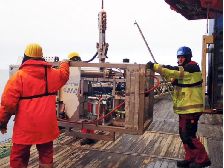
Figure 1: The Ocean Floor Observation and Bathymetry System (OFOBS) of the Alfred Wegener Institute (AWI),
Helmholtz Centre for Polar and Marine Research Bremerhaven, deployed from the RV Polarstern during cruise PS118 in the waters east of the Antarctic Peninsula and on the flanks of the Powell Basin (Feb – April 2019)
195
Figure 2: Regional map showing the positions of OFOBS deployments made during RV Polarstern cruise PS118.
200
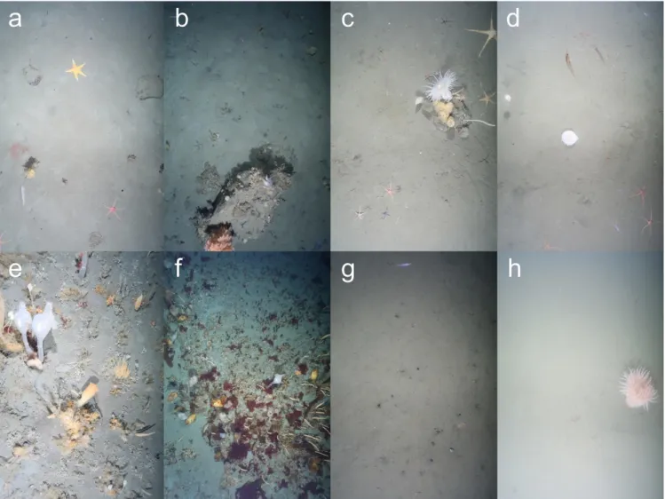
Figure 3: Typical seafloor images collected from each of the OFOBS surveys made of the Weddell Sea seafloor during RV Polarstern cruise PS118. a) Station PS118_6, hotkey_2019_03_06 at 05_07_31 b) Station PS118_7, hotkey_2019_03_06 at 19_36_28 c) Station PS118_8, hotkey_2019_03_11 at 14_33_24 d) Station PS118_9, timer_2019_03_12 at 06_01_06 e) Station PS118_11, timer_2019_03_13 at 20_14_04 f) Station PS118_11, timer_2019_03_13 at 22_18_47 g) Station 205
PS118_12, timer_2019_03_15 at 01_29_36 h) Station PS118_38, hotkey_2019_03_23 at 06_27_00
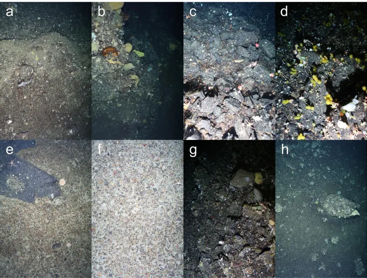
Figure 4: Typical seafloor and cliff escarpment images collected during OFOBS surveys of the Powell Basin flanks during 210
RV Polarstern cruise PS118 . a) Station PS118_39, hotkey_2019_03_23 at 23_21_46 b) Station PS118_39, timer_2019_03_25 at 18_50_09 c) Station PS118_69, hotkey_2019_03_31 at 12_20_55 d) Station PS118_69, hotkey_2019_03_31 at 14_10_56 e) Station PS118_77, timer_2019_04_01 at 20_39_51 f) Station PS118_77, timer_2019_04_01 at 20_11_32 g) Station PS118_81, timer_2019_04_04 at 00_25_31 h) Station PS118_81, timer_2019_04_04 at 02_27_33
215
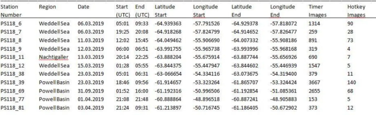
11 TABLES
Table 1: Locations of OFOBS deployments during PS118. Start and end position co-ordinates and times are given, in addition to the numbers of
‘timer’ and ‘hotkey’ images collected during each deployment.
220