© Author(s) 2020. This work is distributed under the Creative Commons Attribution 4.0 License.
An integrated compilation of data sources for the development of a marine protected area
in the Weddell Sea
Katharina Teschke1,2, Hendrik Pehlke1,2, Volker Siegel3, Horst Bornemann1, Rainer Knust1, and Thomas Brey1,2,4
1Alfred-Wegener-Institut Helmholtz-Zentrum für Polar- und Meeresforschung, Am Handelshafen 12, 27570 Bremerhaven, Germany
2Helmholtz Institute for Functional Marine Biodiversity at the University Oldenburg (HIFMB), Ammerländer Heerstraße 231, 26129 Oldenburg, Germany
3Thünen Institute of Sea Fisheries, Herwigstraße 31, 27572 Bremerhaven, Germany
4University of Bremen, Bibliothekstraße 1, 28359 Bremen, Germany Correspondence:Katharina Teschke (katharina.teschke@awi.de)
Received: 27 May 2019 – Discussion started: 5 July 2019
Revised: 9 March 2020 – Accepted: 23 March 2020 – Published: 4 May 2020
Abstract. The Southern Ocean may contribute a considerable amount to the proposed global network of marine protected areas (MPAs) that should cover about 10 % of the world’s oceans in 2020. In the Antarctic, the Commission for the Conservation of Antarctic Marine Living Resources (CCAMLR) is responsible for this task, and currently Germany leads a corresponding scientific evaluation of the wider Weddell Sea region. Compared to other marine regions within the Southern Ocean, the Weddell Sea is exceptionally well investigated. A tremendous amount of data and information has been produced over the last 4 decades. Here, we give a systematic overview of all data sources collected in the context of the Weddell Sea MPA planning process. The compilation of data sources is comprised of data produced by scientists and institutions from more than 20 countries that were either available within our institutes, downloaded via data portals or transcribed from the literature. It is the first compilation for this area that includes abiotic data, such as bathymetry and sea ice, and ecological data from zooplankton, zoobenthos, fish, birds and marine mammals. All data layer products based on this huge compilation of environmental and ecological data are available from the data publisher PANGAEA via the six persistent identifiers at https://doi.org/10.1594/PANGAEA.899595 (Pehlke and Teschke, 2019), https://doi.org/10.1594/PANGAEA.899667 (Teschke et al., 2019a), https://doi.org/10.1594/PANGAEA.899645 (Teschke et al., 2019b), https://doi.org/10.1594/PANGAEA.899591 (Teschke et al., 2019c), https://doi.org/10.1594/PANGAEA.899520 (Pehlke et al., 2019a) and https://doi.org/10.1594/PANGAEA.899619 (Pehlke et al., 2019b). This compilation of data sources in- cluding the final data layer products will serve future research and monitoring well beyond the current MPA development process.
1 Introduction
Marine protected areas (MPAs) have experienced a signifi- cant increase in number and coverage at a global scale dur- ing recent decades (e.g. Mora and Sale, 2011; McDermott et al., 2018; UNEP-WCMC and IUCN, 2019). The number of MPAs has increased almost 1.5 times since the 1990s and the total area protected is currently almost 30 million km2. At the United Nations World Summit on Sustainable Develop- ment in 2002 the international community of states reached an agreement about the establishment of a representative net- work of MPAs for the purpose of long-term conservation of marine biodiversity by 2012 (A/CONF.199/20, 2002). The adopted “strategic plan for biodiversity 2011–2020” of the Convention on Biological Diversity aims for the conserva- tion of at least 10 % of coastal and offshore marine areas by 2020 based on a MPA network (CBD, 2010). The Southern Ocean may contribute a considerable proportion of this MPA network due to its size, and the uniqueness of the Antarctic environment renders its conservation the more urgent.
The Weddell Sea represents the southerly part of the At- lantic Sector of the Southern Ocean. About a quarter of the Weddell Sea’s entire marine area covers the continental shelf along the eastern contour of the Antarctic Peninsula and the Antarctic continent up to 20◦E as a heuristically chosen non- topographic delineation. The Weddell Sea is deserving of protection in multiple respects. On the one hand, all argu- ments for the conservation of the Southern Ocean hold true for the Weddell Sea as well; i.e. it is an extreme environ- ment that is mostly dominated by the seasonal dynamic of the sea ice and has an excellently adapted biota. The biodi- versity is – particularly in the benthos – very high (e.g. Brey et al., 1994; Brandt et al., 2007), and there is a significant number of endemic species, i.e. unique to the Antarctic or even to the Weddell Sea (e.g. Arntz et al., 1994; Clarke and Johnston, 2003; Linse et al., 2006). Moreover, the Weddell Sea plays an important role for seabirds, penguins and ma- rine mammals. Almost one-third of the entire population of emperor penguins (Fretwell et al., 2012) and a major part of the population of crabeater seals (cf. Bester and Odendaal, 2000; Southwell et al., 2012; Gurarie et al., 2017a, b) ap- parently are found in the Weddell Sea. Sponge associations that are comparable to tropical reef systems in terms of their structural and functional complexity occur along the eastern Weddell Sea shelf (Barthel and Gutt, 1992), and on the broad shelf in the southern Weddell Sea a special benthic commu- nity – adapted to very cold water temperatures – seems to be resident (Teschke et al., 2016).
The Weddell Sea is – despite being one of the most re- mote and inaccessible places on Earth – relatively well in- vestigated compared to other Antarctic regions. For approx- imately 30 years the Weddell Sea has been the geograph- ical focus area of German Antarctic research. In addition, there are manifold research activities of other nations. Conse- quently, we were able to compile a tremendous amount of en-
vironmental and ecological data to support the development of a Weddell Sea MPA (WSMPA) under the Commission for the Conservation of Antarctic Marine Living Resources (CCAMLR). Here, we present a systematic overview of all environmental and ecological data sources collected for the development of a WSMPA and provide data layer products that are based on this data compilation.
2 Data description 2.1 Study site
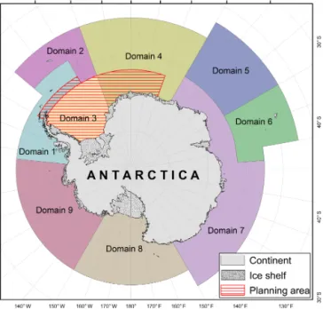
The WSMPA Planning Area in which we acquired the envi- ronmental and ecological data is located between the Antarc- tic Peninsula and 20◦E (Fig. 1). The northern border is at 64◦S and the continental margin forms the southern bor- der. This area is defined by CCAMLR’s MPA Planning Domains in the CCAMLR Convention Area (SC-CAMLR- XXX, 2011) and by aiming at a bio-geographically ho- mogeneous area, particularly on the shelf (Teschke et al., 2016). In addition to the WSMPA Planning Area (approx.
4.2 million km2in size) we compiled data for a 200 km wide buffer area near the Antarctic Peninsula, which is part of an MPA initiative led by Argentina and Chile (CCAMLR- XXXVII/31, 2018). This buffer zone is adjacent to the north- ern border of the WSMPA Planning Area and has eastern and western boundaries at 30 and 60◦W, respectively. Some data (e.g. seal tracking data) extend beyond the WSMPA Plan- ning Area (plus buffer) and originate from adjacent regions of the Weddell Sea, such as the Bellinghausen Sea along the western side of the Antarctic Peninsula.
2.2 Data compilation
All raw data sets of environmental and ecological parameters collected by the end of 2016 and further processed as part of the WSMPA planning process are systematically described, and the primary reference is mentioned, such as the data por- tal from which the data are freely available or the website of the institute or organisation from which the data can be re- quested (see Tables 1 and 2; see all data records in Figs. 2 and S1 in the Supplement). For each individual raw data set in Tables 1 and 2, the accessibility status is indicated; i.e. it is immediately clear which data sets are directly freely avail- able and which data sets must first be requested.
In addition, we offer data layer products that we de- veloped on the basis of the raw data sets whose sources are described here. The methods used to process and analyse the data and to develop each data layer are de- scribed in detail in the Supplement. All data layer products with a metadata description are freely available from the data publisher PANGAEA via the six persistent iden- tifiers at https://doi.org/10.1594/PANGAEA.899595
(Pehlke and Teschke, 2019),
https://doi.org/10.1594/PANGAEA.899667 (Teschke et
Table1.Datacollectionofenvironmentalparameterscompiledforthedevelopmentofamarineprotectedarea(MPA)inthewiderWeddellSea(Antarctica).Foreachrawdataset, thenameofthedatasource,theprimaryreference,suchasthedataportalorwebsiteonwhichthedataareavailable,andexamplesofpublicationsthathaveusedtherespectiveraw datasetarelisted.Inaddition,DOIlinksareprovidedtothefinalWSMPAdatalayerproductswheretherespectiveenvironmentalrawdatasetshavebeenmapped(asinthepelagic regionalisationapproach)orusedasexplanatoryvariablesforthedevelopmentofspeciesdistributiondatalayers. ContentNameReferencetorawdataAvailabilityofrawdataReference(s)topubli- cationsthathaveused therawdata(exemplar- ily)
DOIlinktoArcMap packages DepthInternationalBathymetric ChartoftheSouthernOcean (IBCSO)Version1.0
Arndtetal.(2013b), https://doi.org/10.1594/PANGAEA.805736 (datarequest:April2013)
freelyavailableArndtetal.(2013a) Jeroschetal.(2016)https://doi.org/10.1594/PANGAEA.899595 (PehlkeandTeschke,2019) https://doi.org/10.1594/PANGAEA.899667 (Teschkeetal.,2019a) https://doi.org/10.1594/PANGAEA.899591 Seaice concentrationDailyAMSR-ESeaIceMapshttps://seaice.uni-bremen.de/data/ (datarequest:18December2013)freelyavailableSpreenetal.(2008)https://doi.org/10.1594/PANGAEA.899595 (PehlkeandTeschke,2019) https://doi.org/10.1594/PANGAEA.899667 (Teschkeetal.,2019a) Temperature,salin- ity,currentvelocityFiniteElementSeaIce–Ocean Model(FESOM)https://www.awi.de/forschung/ klimawissenschaften/klimadynamik (datadelivery:20November2013)
requestnecessaryDanilovetal.(2004) Timmermannetal. (2009) HaidandTimmerman (2013)
https://doi.org/10.1594/PANGAEA. 899595(PehlkeandTeschke,2019) https://doi.org/10.1594/PANGAEA.899645 (Teschkeetal.,2019b) https://doi.org/10.1594/PANGAEA.899667 (Teschkeetal.,2019a) https://doi.org/10.1594/PANGAEA.899591 (Teschkeetal.,2019c) Dissolvedoxygen, phosphate,nitrateWorldOceanAtlas2013ver- sion2(WOA13V2)https://www.nodc.noaa.gov/OC5/woa13/ woa13data.html (datarequest:11to18July2013)
freelyavailableGarciaetal.(2014a,b)https://doi.org/10.1594/PANGAEA.899667 (Teschkeetal.,2019a) https://doi.org/10.1594/PANGAEA.899591 (Teschkeetal.,2019c) Totalorganic carboncontentSeiteretal.(2004b), https://doi.org/10.1594/PANGAEA.199835freelyavailableSeiteretal.(2004a)https://doi.org/10.1594/PANGAEA.899591 (Teschkeetal.,2019c) Calciumcarbonate, silicaSeiteretal.(2004c), https://doi.org/10.1594/PANGAEA.186024freelyavailableSeiteretal.(2004a)https://doi.org/10.1594/PANGAEA.899591 (Teschkeetal.,2019c) BiogenicsilicaGeibertetal.(2005b), https://doi.org/10.1594/PANGAEA.230042freelyavailableGeibertetal.(2005a)https://doi.org/10.1594/PANGAEA.899591 (Teschkeetal.,2019c) Chlorophyllacon- centrationSea-ViewingWide Field-of-ViewSensor (SeaWiFS)measurements
https://oceandata.sci.gsfc.nasa.gov/SeaWiFS/ (datarequest:9September2014)registrationnecessaryMooreandAbbott (2000) GreggandCasey (2004)
https://doi.org/10.1594/PANGAEA.899667 (Teschkeetal.,2019a)
Figure 1. CCAMLR Convention Area, showing the marine pro- tected area (MPA) Planning Domains and the planning area (in- cluding a 200 km wide buffer area near the Antarctic Peninsula) for the development of a MPA in the wider Weddell Sea (red-shaded area). Domain 1 – Western Peninsula–South Scotia Arc; Domain 2 – North Scotia Arc; Domain 3 – Weddell Sea; Domain 4 – Bou- vet Maud; Domain 5 – Crozet–del Cano; Domain 6 – Kerguelen Plateau; Domain 7 – Eastern Antarctica; Domain 8 – Ross Sea; Do- main 9 – Amundsen–Bellingshausen.
al., 2019a), https://doi.org/10.1594/PANGAEA.899645
(Teschke et al., 2019b),
https://doi.org/10.1594/PANGAEA.899591 (Teschke et al., 2019c), https://doi.org/10.1594/PANGAEA.899520
(Pehlke et al., 2019a) and
https://doi.org/10.1594/PANGAEA.899619 (Pehlke et al., 2019b) (see Tables 1 and 2). The data layers are available either as ArcMap packages (as a .mxd file, containing a map document with all associated files) or as individual GIS files for those who use GIS software other than the ESRI software (ArcMap). The shape and raster files, all of which have the same spheroid (WGS 1984, EPSG 4326) and projection (South Pole Lambert Azimuthal Equal Area, EPSG 102020), were processed in such a way that they can be easily used for the analysis of MPA scenarios or other geostatistical analyses in the Weddell Sea without direct access to the underlying raw data. For example, the shape and raster files could be stacked to identify hotspots and cold spots of biodiversity, or certain layers could be used as explanatory variables in species distribution models.
2.3 Environmental data 2.3.1 IBCSO data
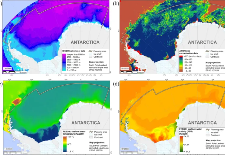
The bathymetric data used in the context of the WSMPA planning initiative originate from the first regional digital bathymetric model (DBM) established in the International Bathymetric Chart of the Southern Ocean (IBCSO) Version 1.0 programme (data request: April 2013) (Table 1; Fig. 3a).
This chart model is based upon bathymetric data of differ- ent origins, such as multi-beam and single-beam data; digi- tised depths from nautical charts; and predicted bathymetry from many hydrographic offices, scientific institutions, and data centres. The IBCSO Version 1.0 DBM has a horizontal resolution of 500 m×500 m and a vertical resolution of 1 m based on a polar stereographic projection with true scale at 65◦referenced to the WGS84 ellipsoid (Arndt et al., 2013a, b).
2.3.2 AMSR-E sea ice maps
Daily high-resolution sea ice maps of the Antarctic Ocean are provided by the PHAROS group (PHysical Analysis of RemOte Sensing images) at the Institute of Environmental Physics, University of Bremen, Germany. The sea ice raster maps, which were used in the context of the WSMPA plan- ning initiative, are derived from satellite observations of daily sea ice concentration by the Advanced Microwave Scanning Radiometer – Earth Observing System (AMSR-EOS) instru- ment on board the Aqua satellite. Daily AMSR-E sea ice maps (2013) (June 2002–October 2011) were downloaded from IUP, University of Bremen (data request: 18 Decem- ber 2013) (see Table 1; Fig. 3b). The ARTIST Sea Ice (ASI) concentration algorithm was used with a spatial resolution of 6.25 km×6.25 km (Spreen et al., 2008) and a polar stereo- graphic projection (EPSG: 3976).
2.3.3 FESOM data
Monthly mean values of seawater temperature, salinity and current velocity from 1990 to 2009 were derived from the Finite Element Sea Ice – Ocean Model (FESOM) (Table 1;
Fig. 3c, d). The model run was initialised on 1 January 1980 with hydrographic data from the Polar Science Center Hy- drographic Climatology (Steele et al., 2001), and forced with NCEP daily atmospheric re-analysis data (Kalnay et al., 1996) for 1980 to 2009. For more information on FESOM and the atmospheric-forcing data sets, see, e.g. Timmermann et al. (2009) and Haid and Timmermann (2013), respectively.
The FESOM raster has a resolution of 0.18◦(x)×0.05◦(y);
in the vertical, twozlevels (i.e. sea surface and sea bottom) are used. The raster is based on the WGS84 geographic co- ordinate system (EPSG: 4326).
IBCSO data, AMSR-E sea ice maps and FESOM data were used in a pelagic regionalisation analysis of the Wed- dell Sea. The respective data layer products are avail-
Table2.Datacollectionofecologicalparameterscompiledforthedevelopmentofamarineprotectedarea(MPA)inthewiderWeddellSea(Antarctica).Foreachrawdataset,the nameofthedatasource,theprimaryreference,suchasthedataportalorwebsiteonwhichthedataareavailable,andtherespectivecruisereportsand/orexamplesofpublicationsthat haveusedtherespectiverawdatasetarelisted.Inaddition,DOIlinkstothefinalWSMPAdatalayerproductsareprovided,includingtherespectiverawdatasets. ContentNameReferencetorawdataAvailabilityofraw dataCruisereportReferencetopublica- tionsthathaveusedthe rawdata(exemplarily)
DOIlinktoArcMap packages Zooplankton AdultAntarctickrill (abundances)KRILLBASE (https://doi.org/brg8) SeedetailedlistofdatainTable S2inSupplement
Atkinsonetal.(2017)requestnecessaryAtkinsonetal.(2004) Atkinsonetal.(2008) PiˇnonesandFedorov (2016) Atkinsonetal.(2019)
https://doi.org/10.1594/ PANGAEA.899667 (Teschkeetal.,2019a) AdultAntarctickrill (catchandeffort)Japanese,NorwegianandSo- vietfisheriesdatahttps://www.ccamlr.org/ (datarequest:3October2013)requestnecessaryhttps://doi.org/10.1594/ PANGAEA.899667 (Teschkeetal.,2019a) AdultAntarctickrill (abundances)Sovietcruises:RVGizhiga 1977andRVVolnyVetter1983https://www.thuenen.de/en/sf/requestnecessaryhttps://doi.org/10.1594/ PANGAEA.899667 (Teschkeetal.,2019a) AdultAntarctickrill (abundances)ANT-XVIII/4https://www.thuenen.de/en/sf/requestnecessaryFahrbachetal.(2003)https://doi.org/10.1594/ PANGAEA.899667 (Teschkeetal.,2019a) AdultAntarctickrillandice krill(abundances)MVPolarsirkel1976/1977Fevolden(1979), https://doi.org/10.1080/00364827.1979freelyavailablehttps://doi.org/10.1594/ PANGAEA.899667 (Teschkeetal.,2019a) AdultAntarctickrillandice krill(abundances)LazarevSeaKrillStudy (LAKRIS)data(ANT-XXI/4, ANT-XXIII/2,ANT-XXIII/6, ANT-XXIV/2)
https://www.thuenen.de/en/sf/requestnecessarySmetaceketal.(2005) Strass(2007) Bathmann (2008,2010)
Siegel(2012)https://doi.org/10.1594/ PANGAEA.899667 (Teschkeetal.,2019a) AdultAntarctickrillandice krill(abundances)ANT-XXIX/3https://www.thuenen.de/en/sf/requestnecessaryGutt(2013)Siegeletal.(2013)https://doi.org/10.1594/ PANGAEA.899667 (Teschkeetal.,2019a) AdultAntarctickrillandice krill(abundances)ANT-V/3https://www.thuenen.de/en/sf/requestnecessarySchnack-Schiel(1987)https://doi.org/10.1594/ PANGAEA.899667 (Teschkeetal.,2019a) AdultAntarctickrillandice krill(abundances)ANT-VII/4https://www.thuenen.de/en/sf/requestnecessaryArntzetal.(1990)https://doi.org/10.1594/ PANGAEA.899667 (Teschkeetal.,2019a) Adulticekrill (abundances)RVWaltherHerwig1975/1976https://www.thuenen.de/en/sf/requestnecessaryhttps://doi.org/10.1594/ PANGAEA.899667 (Teschkeetal.,2019a) Adulticekrill (abundances)MVPolarsirkel1979/1980https://www.thuenen.de/en/sf/requestnecessarySiegel(1982) Hempeletal.(1983)https://doi.org/10.1594/ PANGAEA.899667 (Teschkeetal.,2019a)
Table2.Continued.
ContentNameReferencetorawdataAvailabilityofrawdata CruisereportReferencetopublica-tionsthathaveusedtherawdata(exemplarily) DOIlinktoArcMappackages
LarvalAntarctickrill(abundances) MVPolarsirkel1976/1977 Fevolden(1979),https://doi.org/10.1080/00364827.1979 freelyavailablehttps://doi.org/10.1594/PANGAEA.899667(Teschkeetal.,2019a)
LarvalAntarctickrill(abundances) MVPolarsirkel1979/1980 https://www.thuenen.de/en/sf/requestnecessarySiegel(1982)https://doi.org/10.1594/PANGAEA.899667(Teschkeetal.,2019a)
LarvalAntarctickrill(abundances) FirstInternationalBIOMASSExperimentsurvey(FIBEX),RVWaltherHerwig1981 https://www.thuenen.de/en/sf/requestnecessaryTrathanandEverson(1994)Siegel(2005) https://doi.org/10.1594/PANGAEA.899667(Teschkeetal.,2019a)
LarvalAntarctickrill(abundances) ANT-VII/4https://www.thuenen.de/en/sf/requestnecessaryArntzetal.(1990)https://doi.org/10.1594/PANGAEA.899667(Teschkeetal.,2019a)LarvalAntarctickrill(abundances) ANT-VIII/2andRVAkademikFedorov,1989 https://www.thuenen.de/en/sf/requestnecessaryAugsteinetal.(1991)Menshenina(1992)https://doi.org/10.1594/PANGAEA.899667(Teschkeetal.,2019a)
LarvalAntarctickrill(abundances) LazarevSeaKrillSurvey(LAKRIS)data(ANT-XXI/4,ANT-XXIII/6) https://www.thuenen.de/en/sf/requestnecessarySmetaceketal.(2005)Bathmann(2008) Siegel(2012)https://doi.org/10.1594/PANGAEA.899667(Teschkeetal.,2019a)
Zoobenthos
Sponges(abundances)WH068/1WH068/2ANT-III/2ANT-V/1ANT-VI/3ANT-VII/4ANT-IX/3ANT-X/3ANT-XIII/3ANT-XIII/4
ANT-XV/3ANT-XVII/3ANT-XIX/5ANT-XXI/2ANT-XXIIIANT-XXVII Gerdes(2014a–p),https://doi.org/10.1594/PANGAEA.834061https://doi.org/10.1594/PANGAEA.834065https://doi.org/10.1594/PANGAEA.834009https://doi.org/10.1594/PANGAEA.717708https://doi.org/10.1594/PANGAEA.834017https://doi.org/10.1594/PANGAEA.834021https://doi.org/10.1594/PANGAEA.834013https://doi.org/10.1594/PANGAEA.834025https://doi.org/10.1594/PANGAEA.834029https://doi.org/10.1594/PANGAEA.834033
https://doi.org/10.1594/PANGAEA.834041https://doi.org/10.1594/PANGAEA.834074https://doi.org/10.1594/PANGAEA.834069https://doi.org/10.1594/PANGAEA.834049https://doi.org/10.1594/PANGAEA.834053https://doi.org/10.1594/PANGAEA.834057 freelyavailable––Hempel(1985)Schnack-Schiel(1987)Fütterer(1988)Arntzetal.(1990)Bathmannetal.(1992)Spindleretal.(1993)ArntzandGutt(1997)FahrbachandGerdes(1997)ArntzandGutt(1999)ArntzandBrey(2001)ArntzandBrey(2003)ArntzandBrey(2005)Gutt(2008)Knustetal.(2012) Gerdesetal.(1992)Gerdesetal.(2003) https://doi.org/10.1594/PANGAEA.899645(Teschkeetal.,2019b)
Sponges(semi-quantitativedata) ANT-VII/4ANT-IX/3ANT-XIII/3ANT-XV/3ANT-XXI/2 TeschkeandBrey(2020),https://doi.org/10.1594/PANGAEA.911801 freelyavailableArntzetal.(1990)Bathmannetal.(1992)ArntzandGutt(1997)ArntzandGutt(1999)ArntzandBrey(2005) Galéronetal.(1992)https://doi.org/10.1594/PANGAEA.899645(Teschkeetal.,2019b)
Table2.Continued. ContentNameReferencetorawdataAvailabilityofraw dataCruisereportReferencetopublica- tionsthathaveusedthe rawdata(exemplarily)
DOIlinktoArcMap packages Echinoderms–Asteroids (presence–absence)ANT-I/2 ANT-II/4 ANT-V/3 ANT-VI/3 ANT-XV/3 ANT-XVII/3
TeschkeandBrey(2019a), https://doi.org/10.1594/PANGAEA.898629freelyavailableDrescheretal.(1983) Kohnen(1984) Schnack-Schiel(1987) Fütterer(1988) ArntzandGutt(1999) ArntzandBrey(2001)
Voß(1988)https://doi.org/10.1594/ PANGAEA.899645 (Teschkeetal.,2019b) Echinoderms– Ophiuroids (abundances)
ANT-I/2 ANT-II/4 ANT-V/3 ANT-V/4 ANT-VI/3 ANT-VII/4 ANT-IX/3 ANT-X/3
TeschkeandBrey(2019b), https://doi.org/10.1594/PANGAEA.898773freelyavailableDrescheretal.(1983) Kohnen(1984) Schnack-Schiel(1987) MillerandOerter(1990) Fütterer(1988) Arntzetal.(1990) Bathmannetal.(1992) Spindleretal.(1993)
Breyetal.(1994) Dahm(1996)https://doi.org/10.1594/ PANGAEA.899645 (Teschkeetal.,2019b) Echinoderms– Holothurians (abundances)
ANT-I/2 ANT-II/4 ANT-III/3
Guttetal.(2014), https://doi.org/10.3897/zookeys.434.7622freelyavailableDrescheretal.(1983) Kohnen(1984) Hempel(1985)
Gutt(1988) Piepenburgetal.(1997)https://doi.org/10.1594/ PANGAEA.899645 (Teschkeetal.,2019b) Fishes Pleuragrammaantarctica anddemersalfishes (abundances)
ANT-XIII/3 ANT-XV/3 ANT-XVII/3 ANT-XIX/5 ANT-XXI/2 ANT-XXVII/3
BalgueríasandKnust(2020), https://doi.org/10.1594/PANGAEA.911965 KnustandSchröder(2020), https://doi.org/10.1594/PANGAEA.911966 Knustetal.(2020a), https://doi.org/10.1594/PANGAEA.911967 Knustetal.(2020b), https://doi.org/10.1594/PANGAEA.911968 Knustetal.(2020c), https://doi.org/10.1594/PANGAEA.911969 Knustetal.(2020d), https://doi.org/10.1594/PANGAEA.911970
freelyavailable freelyavailable freelyavailable freelyavailable freelyavailable freelyavailable
ArntzandGutt(1997) ArntzandGutt(1999) ArntzandBrey(2001) ArntzandBrey(2003) ArntzandBrey(2005) Knustetal.(2012)
Mintenbecketal. (2012) Caccavoetal.(2018)
https://doi.org/10.1594/ PANGAEA.899591 (Teschkeetal.,2019c) Pleuragrammaantarctica anddemersalfishes (abundances)
ANT-I/2 ANT-III/3 ANT-V/3 ANT-VII/4 ANT-IX/3 ANT-XXIII/8
Drescheretal.(2012), https://doi.org/10.1594/PANGAEA.786877 Ekauetal.(2012a), https://doi.org/10.1594/PANGAEA.786883 Ekauetal.(2012b), https://doi.org/10.1594/PANGAEA.786884 Hureauetal.(2012), https://doi.org/10.1594/PANGAEA.786886 Wöhrmannetal.(2012), https://doi.org/10.1594/PANGAEA.786887 Kocketal.(2012), https://doi.org/10.1594/PANGAEA.786888
freelyavailable freelyavailable freelyavailable freelyavailable freelyavailable freelyavailable
Drescheretal.(1983) Hempel(1985) Schnack-Schiel(1987) Arntzetal.(1990) Bathmannetal.(1992) Gutt(2008)
Ekau(1988) Caccavoetal.(2018)https://doi.org/10.1594/ PANGAEA.899591 (Teschkeetal.,2019c)
Table2.Continued.
ContentNameReferencetorawdataAvailabilityofrawdata CruisereportReferencetopublica-tionsthathaveusedtherawdata(exemplarily) DOIlinktoArcMappackages
Fishlarvae–Pleuragrammaantarctica(abundances) ANT-I/2https://www.thuenen.de/en/sf/requestnecessaryDrescheretal.(1983),Boysen-EnnenandPiatkowski(1988) https://doi.org/10.1594/PANGAEA.899591(Teschkeetal.,2019c) Fishlarvae–Pleuragrammaantarctica(abundances) ANT-III/3Huboldetal.(1988),https://doi.org/10.1007/BF00443454 freelyavailableHempel(1985)https://doi.org/10.1594/PANGAEA.899591(Teschkeetal.,2019c) Fishlarvae–Pleuragrammaantarctica(abundances) LazarevSeaKrillStudy(LAKRIS)data:ANT-XXI/4,ANT-XXIII/6,ANT-XXIV/2 https://www.awi.de/forschung/biowissenschaften/polare-biologische-ozeanographie(datarequest:13December2013) requestnecessarySmetaceketal.(2005)Bathmann(2008,2010) Floresetal.(2014)https://doi.org/10.1594/PANGAEA.899591(Teschkeetal.,2019c)
Antarctictoothfish(catchperuniteffort) Japanese,Korean,NorwegianandSouthAfricanfishingdata https://www.ccamlr.org(datarequest:3August2016) requestnecessaryhttps://doi.org/10.1594/PANGAEA.899591(Teschkeetal.,2019c)
DemersalfishnestingsitesPS82(ANT-XXIX/9)
PS96(ANT-XXXI/2) KnustandSchröder(2014),https://doi.org/10.2312/BzPM_0680_2014Piepenburg(2016),https://doi.org/10.1594/PANGAEA.862097 freelyavailable
freelyavailable Schröder(2016)LaMesaetal.(2019)https://doi.org/10.1594/PANGAEA.899591(Teschkeetal.,2019c)
DemersalfishnestingsitesDaniels(1978,1979),https://doi.org/10.1111/j.1095-8649.1978.tb04190.xhttps://doi.org/10.1126/science.205.4408.831JonesandNear(2012),https://doi.org/10.1111/j.1095-8649.2012.03282.x freelyavailable
freelyavailable https://doi.org/10.1594/PANGAEA.899591(Teschkeetal.,2019c)
Birds
Adéliepenguincolonies(estimatedabundancesofbreedingpairs) LynchandLaRue(2014),https://doi.org/10.1642/AUK-14-31.1 freelyavailablehttps://doi.org/10.1594/PANGAEA.899520(Pehlkeetal.,2019a)
Breedingandnon-breedingAdéliepenguins(trackingdata) USAMLRProgram(ID910) http://www.seabirdtracking.org/(datarequest:20October2015) requestnecessaryHinkeetal.(2015)https://doi.org/10.1594/PANGAEA.899520(Pehlkeetal.,2019a)
Breedingandnon-breedingAdéliepenguins(trackingdata) BAS/InstitutoAntár-ticoArgentinodata(ID753) http://www.seabirdtracking.org/(datarequest:20October2015) requestnecessaryWarwick-Evansetal.(2019) https://doi.org/10.1594/PANGAEA.899520(Pehlkeetal.,2019a)
Breedingandnon-breedingAdéliepenguins(trackingdata) BASInventory(754,773,779) http://www.seabirdtracking.org/(datarequest:20October2015) requestnecessaryDunnetal.(2011)https://doi.org/10.1594/PANGAEA.899520(Pehlkeetal.,2019a)
BreedingAdéliepenguins(trackingdata) BASInventory(ID764) http://www.seabirdtracking.org/(datarequest:20October2015) requestnecessaryLynnesetal.(2002)https://doi.org/10.1594/PANGAEA.899520(Pehlkeetal.,2019a)
Table2.Continued. ContentNameReferencetorawdataAvailabilityofraw dataCruisereportReferencetopublica- tionsthathaveusedthe rawdata(exemplarily)
DOIlinktoArcMap packages Pinnipeds Emperorpenguin colonies(populations estimates)
Fretwelletal.(2012), https://doi.org/10.1371/journal.pone.0033751 Fretwelletal.(2014), https://doi.org/10.1371/journal.pone.0085285
freelyavailable freelyavailable
https://doi.org/10.1594/ PANGAEA.899520 (Pehlkeetal.,2019a) Antarcticpetrel colonies(estimated numberofbreedingpairs)
VanFranekeretal.(1999), https://doi.org/10.2307/1521989freelyavailablehttps://doi.org/10.1594/ PANGAEA.899520 (Pehlkeetal.,2019a) Sealtaxa (trackingdata)Datafrom:Australia (ct109,ct96),Brazil (ct56,ct46,ct39,ct22), China(ct105),UK(ct1, ct8,ct27,ct27x,ct40, ct43,ct45,ct49,ct58, ct70),France(ct16, ct62,ft01,ft02,ft11, ft12),Germany(ct21, ct35,ct35b,ct44,ct54, ct68,ct87,ct99,ct102, ct113,wd06,wd07), Norway(ct34),South Africa(ct33,ct50, ct73),USA(ct9,ct14, ct25,ct29,ct37,ct48)
http://www.meop.net/ (datarequest:14November2016)registration necessaryTreasureetal.(2017) Nachtsheimetal. (2019) Boehmeetal.(2016)
https://doi.org/10.1594/ PANGAEA.899619 (Pehlkeetal.,2019b) Southernelephantseals (trackingdata)Toshetal.(2009a), https://doi.org/10.1594/PANGAEA.692856 Jamesetal.(2012a), https://doi.org/10.1594/PANGAEA.785852
freelyavailable freelyavailable
Toshetal.(2009b) Jamesetal.(2012b)
https://doi.org/10.1594/ PANGAEA.899619 (Pehlkeetal.,2019b) Weddellseals (trackingdata)McIntyreetal.(2013a), https://doi.org/10.1594/PANGAEA.818467freelyavailableMcIntyreetal.(2013b)https://doi.org/10.1594/ PANGAEA.899619 (Pehlkeetal.,2019b) Crabeaterseals (trackingdata)Nachtsheimetal.(2016a), https://doi.org/10.1594/PANGAEA.854842freelyavailableNachtsheimetal. (2016b),https://doi.org/10.1594/ PANGAEA.899619 (Pehlkeetal.,2019b) Pack-iceseals (aerialsurveys)AntarcticPackIce Seals(APIS) programme EMAGE-Ito-V
Plötzetal.(2011a–e), https://doi.org/10.1594/PANGAEA.760097 https://doi.org/10.1594/PANGAEA.760098 https://doi.org/10.1594/PANGAEA.760099 https://doi.org/10.1594/PANGAEA.760100 https://doi.org/10.1594/PANGAEA.760101
freelyavailableSouthwelletal.(2012) Gurarieetal.(2017a,b)https://doi.org/10.1594/ PANGAEA.899619 (Pehlkeetal.,2019b) Crabeatersealdensities (predictedorobserved)Besteretal.(1995,2002), https://doi.org/10.1017/S0954102095000502 https://doi.org/10.1017/S0954102002000676 Floresetal.(2008), https://doi.org/10.1016/j.dsr2.2007.12.024 Forcadaetal.(2012), https://doi.org/10.1016/j.biocon.2012.02.002
freelyavailable freelyavailable freelyavailable
https://doi.org/10.1594/ PANGAEA.899619 (Pehlkeetal.,2019b)
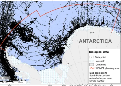
Figure 2.Distribution of all data recordings across the wider Weddell Sea region compiled in the context of the WSMPA planning initiative.
Figure S1 in the Supplement provides the distribution of data recordings per higher taxonomic group, i.e. zooplankton, zoobenthos, fishes, birds and pinnipeds.
able at https://doi.org/10.1594/PANGAEA.899595 (Pehlke and Teschke, 2019) (“Pelagic regionalisation – clustering approach”). The clustering approach to classifying differ- ent pelagic provinces is described in the Supplement. In addition, the data sets were used as environmental vari- ables in various geostatistical approaches to develop spa- tial distribution maps for (i) adult Antarctic krill (AMSR-E), (ii) ice krill (IBCSO, FESOM), (iii) echinoderms (FESOM), (iv) demersal fish (IBCSO, FESOM), (v) Antarctic toothfish (IBCSO), (vi) Antarctic petrel (IBCSO, AMSR-E, FESOM) and (vii) emperor penguins (AMSR-E). The methods used to develop the different spatial distribution maps are described in the Supplement, and the PANGAEA link to the respec- tive data layer products (including file names) is given in the corresponding subsection under Sect. 2.4.
2.3.4 SeaWiFS data
Near-surface chlorophyll a concentration values stem from the Sea-Viewing Wide Field-of-View Sensor (SeaWiFS) measurements on board the OrbView-2 (formerly SeaStar) spacecraft (Table 1). The monthly aggregated data (1997 to 2010) were downloaded as level 3 standard mapped images (L3SMI) with a spatial resolution of 9 km×9 km (data re- quest: 9 September 2014).
2.3.5 WOA13 data
Data on dissolved oxygen, phosphate and nitrate were ob- tained from the World Ocean Atlas 2013 version 2 (WOA13
V2) (Garcia et al., 2014a, b) (Table 1). The data (1955 to 2012) were downloaded as monthly statistical means with a horizontal resolution of 1◦(x)×1◦(y) and 57 and 37 ver- tical (z) levels between 0 to 1500 and 0 to 500 m for dis- solved oxygen and phosphate or nitrate, respectively. The data requests were made on 11 July 2013 (dissolved oxy- gen), 17 July 2013 (nitrate) and 18 July 2013 (phosphate), respectively.
2.3.6 Data on chemical sediment components
A data compilation of total organic carbon content and cal- cium carbonate and silica in surface sediments was down- loaded from the data archive PANGAEA (Seiter et al., 2004a, b, c, and references therein) (see Table 1). Data on bio- genic silica of the sediment surface were obtained from PAN- GAEA as well (Geibert et al., 2005b).
The data described under Sect. 2.3.4 to 2.3.6 were used as explanatory variables in the Antarctic krill species distribu- tion model (SDM) (SeaWiFS, WOA13, chemical sediment components) and in the demersal fish SDM (WOA13, chem- ical sediment components). The SDMs are described in detail in the Supplement and the PANGAEA link to the respective data layer products (including file names) is given in the cor- responding subsection under Sect. 2.4.
2.4 Ecological data
In the following, we describe the sources of raw data sets used in the WSMPA planning process and indicate which
Figure 3.Raster data sets of environmental parameters, which have been used as basic data in a regionalisation analysis of environmental provinces in the context of the WSMPA planning: IBCSO bathymetry(a), AMSR-E sea ice maps (exemplarily for 15 December 2009)(b), FESOM sea bottom temperature and salinity data (exemplarily for December 2009)(c, d).
data layer product was developed on the basis of which raw data sets. In addition, the methods for processing and analysing the data and for developing each data layer are de- scribed in detail in the Supplement.
2.4.1 Zooplankton Antarctic krill (adults)
The WSMPA data collection of adult Antarctic krill (Eu- phausia superba) originates from (i) historical UK data from
“Discovery Expeditions” (1928–1939) and data collected during the SIBEX cruise by British Antarctic Survey; (ii) five South African data sets from the 1990s; (iii) four Soviet data sets from 1998 and 1990; (iv) Polish data (Witek et al., 1985); and (v) German data from location discovery cruises with MV Polarsirkelin 1979/1980 and 1980/1981 (Siegel, 1982), RVWalther Herwigcruises (1975/1976, 1977/1978), and the 2004 Lazarev Sea Krill Survey (LAKRIS) (RV Po- larstern cruise ANT-XXI/4) (Siegel, 2012). All of the data are publicly available via the database KRILLBASE (2013,
https://doi.org/brg8) (Atkinson et al., 2017) (see Table S2 in the Supplement, which provides a detailed list of data used from KRILLBASE). The data from KRILLBASE were com- plemented by abundance data on E. superba, which were collected (a) during the Norwegian Antarctic research ex- pedition 1976/1977 (MV Polarsirkel); (b) during two So- viet research cruises in 1977 and 1983; (c) in the context of the Lazarev Sea Krill Survey; and (d) during the RVPo- larsterncruises ANT-V/1-3, ANT-VII/4, ANT-XVIII/4, and ANT-XXIX/3 (Table 2). Furthermore, fisheries data onE. su- perbafor the WSMPA Planning Area (i.e. Statistical Subarea 48.5 and the southern part of Subarea 48.6) stem from the CCAMLR database (https://www.ccamlr.org; data request:
3 October 2013) (Table 2).
All of these data were used in a species distribution model (SDM) of adult Antarctic krill and ultimately led to a data layer product showing habitat suitability for adult Antarctic krill in the WSMPA Planning Area (see https://doi.org/10.1594/PANGAEA.899667, Teschke et al., 2019a; “Adult Antarctic krill,Euphausia superba – habitat suitability prediction”).