Architecture, tectonic control and instability of the submarine continental margin offshore Mount
Etna, Italy
DISSERTATION
zur Erlangung des Doktorgrades
an der Mathematisch-Naturwissenschaftlichen Fakultät der Christian-Albrechts-Universität zu Kiel
vorgelegt von Felix Michael Gross
Kiel, 2015
Referent: Prof. Dr. Sebastian Krastel-Gudegast Koreferent: Prof. Dr. Jan Behrmann
Tag der mündlichen Prüfung: 03. Juni 2015 Zum Druck genehmigt:
………
Der Dekan
Hiermit erkläre ich eidesstattlich, dass ich die vorliegende Dissertation selbständig und ohne zuhilfenahme unerlaubter Hilfsmittel angefertigt habe. Bisher ist die Arbeit noch nicht an anderer Stelle im Rahmen eines Prüfungsverfahrens vorgelegt worden. Die Arbeit ist unter Einhaltung der Regeln guter wissenschaftlicher Praxis der Deutschen Forschungsgemeinschaft entstanden.
Kiel, den
Felix Gross
Abstract
The Island of Sicily (southern Italy) is located at the collision zone of the Eurasian Plate and the subducting African Plate. It is one of the most active areas in terms of seismicity in Europe; the trend of the subduction zone and its subducting mechanism, however, are still debated. The structural unrest of the area is documented by large plate ruptures in historical times like the prominent 1693, 1783 and 1908 earthquakes. Especially the 1908 Messina earthquake (~ 80,000 casualties) is of major interest as it was associated with the worst tsunami Italy experienced in the historical time (~2000 casualties). It is still debated whether a plate rupture at the seafloor or a massive submarine landslide triggered the tsunami, which hits the coast of East Sicily and Calabria.
Related to this geodynamic setting, the area is also famous for its active volcanism. The Aeolian Island in the Tyrrhenian Sea form the highly active backarc-volcanism of the Calabrian subduction regime.
Another type of volcano is observed directly at the shore of East Sicily – Mt Etna. Mt Etna is not only Europe’s largest volcano edifice with a recent height of 3323 m a.s.l, furthermore it is well known for its frequent eruptions. Compared to Earth’s history, Mt Etna is a relatively young volcano with an active volcanic history of ~500 ka. The origin of Mt Etna is still debated in several theories have been proposed (e.g., asymmetrical rifting processes, intersection of structural elements, hot spot, extensional tectonics).
Mt Etna’s edifice can be traced mostly onshore and is directly adjacent to the continental margin of the Ionian Sea east of Sicily.
Mt Etna is well known for its onshore edifice flank instability, as its eastern and southern flanks are gliding towards the continental margin in the east. The part of the flank gliding to the east is bound by prominent volcano-tectonic fault systems. The continental margin offshore of the gliding flank is characterized by a prominent bulge, which is not found further to the north or south. The onshore flank movement is well documented and monitored, but the potential continuation of this process towards the continental margin is not well investigated due to a lack of offshore data.
In order to investigate and evaluate the phenomenon of volcano flank instability and its link to continental margin instability, a new high resolution new 2D/3D hydro/seismo-acoustic and geological dataset was acquired during RV METEOR research cruise M86/2 in December 2011/January 2012.
The new dataset shows that not only the volcano edifice reveals an instability; furthermore, the entire continental margin east of the gliding sector of Mt Etna shows indications for recent extensional tectonics related to gravitational spreading. Whereas the northern boundary of the moving volcano flank is well defined by the sharp Pernicana-Provenzana Fault onshore, the offshore continuation reveals a diffuse grade of deformation and cannot be traced as a distinct sharp boundary. In contrast, the offshore southern boundary of the moving flank is clearly imaged by the new data set. It is identified as a right
lateral oblique fault north of Catania Canyon. Two anticlines are present directly in front of the continental margin bulge. These anticlines are bound to half-graben basins towards the east and mark the eastern limits of the volcano flank and continental margin instability. As volcano-tectonic structures like the southern boundary fault can be traced from the volcano edifice across the continental margin towards the continental toe, the whole system is considered as a coupled volcano flank / continental margin gravitational instability and collapse.
During M86/2 a new high-resolution 3D seismic cube at the center of the continental margin between the funnel shaped depositional system of Valle di Archirafi and a prominent amphitheater-like headwall, was collected. By assessing this 3D seismic data, a secondary spreading center was mapped at the center of the continental margin affected by the continental margin gravitational instability. It is located at a structural high, directly adjacent to the massive amphitheater headwall. The structural high hosts a set of normal faults, dipping towards steep amphitheater’s headwall. These faults show indications for recent and ongoing activity, as most of the fault planes are striking out at the seafloor. This fault activity makes to structural high to one of the most striking areas in terms of possible future hazards, related to submarine landslides, in the entire survey area. Next to mass transport deposits, traced in the funnel shaped Valle di Archirafi, the entire continental margin and the continental toe is strongly overprinted by a variety of mass transport deposits in the upper 750 m of the sedimentary record. A typical succession of mass transport deposits directly overlain by tephra layers indicate that volcano induced seismicity and flank deformation prior to an eruption act as important trigger mechanisms for catastrophic slope failures on the continental margin east of Mt Etna. The near-surface mass transport deposits are relatively small but seismic data illustrate significantly larger buried mass transport deposits, which were most likely triggered by similar volcanic processes in the past. The new dataset does not support the theory that the 1908 tsunami was triggered by a massive submarine landslide north of Mt Etna’s continental margin. The proposed slide deposit is overlain by a ~150 m thick succession of in-situ strata. The mass transport deposits seems to be the product of an ancient landslide event and has not occurred just ~100 years ago.
All these findings imply a recently active coupled volcano edifice / continental margin system, which results in instable slopes and submarine mass movements. These findings even increase the geo-hazard potential of the area, which is already very high due to the ongoing seismic activity.
Zusammenfassung
Die Insel Sizilien (Süditalien) ist an der Kollisionszone zwischen der eurasischen- und der sich subduzierenden afrikanischen Platte gelegen. Die Gegend ist bekannt als eine der seismisch aktivsten Zonen in Europa, wobei der genaue Verlauf und die Mechanismen der Subduktionszone immer noch unklar sind. Diese strukturelle Unruhe geht mit großen Plattenverschiebungen einher, die schwerwiegende Erdbeben wie das 1693, 1783 und das 1908 Erdbeben in historischen Zeiten auslösten.
Hierbei ist das 1908 Messina Erdbeben (~ 80,000 Opfer) von großem Interesse, da es von dem fatalsten Tsunami (~2000 Opfer), den die Küsten von Italien seit der Zeitaufzeichnung erfahren haben, begleitet wurde. Es ist nach wie vor nicht geklärt, ob dieser Tsunami, der an den Küsten von Sizilien und Kalabrien anbrandete, von einem Meeresbodenversatz oder einer großen submarinen Hangrutschung ausgelöst wurde.
Einhergehend mit seiner geodynamischen Besonderheit ist die Gegend zudem für den auftretenden aktiven Vulkanismus bekannt. Die Äolischen Inseln in der tyrrhenischen See bilden hierbei den hoch- aktiven Backarc-Vulkanismus der kalabrischen Subduktionszone. Ein anderer Typ von Vulkanismus kann direkt an der Küste von Ost-Sizilien beobachtet werden – der Vulkan Ätna. Mit seiner aktuellen Erhebung von 3323 m über dem Meeresspiegel, ist Ätna nicht nur als das höchste Vulkangebäude Europas, sondern auch für seine oft auftretenden Eruptionen, bekannt. Im Vergleich zur Erdgeschichte handelt es sich bei Ätna um einen relativ jungen Vulkan, dessen erste Aktivität ca. 500 ka zurückliegt.
Der Ursprung von Ätna ist noch nicht endgültig geklärt und es gibt verschiede Ansätze seine Entstehung zu erklären (z.B. asymmetrische Kluft Bildung, Überschneiden von strukturellen Elementen, Hot Spot Vulkanismus, extensionelle Tektonik). Das Vulkangebäude von Ätna kann hauptsächlich am Festland von Ost-Sizilien kartiert werden. Zudem erhebt sich das Vulkangebäude direkt westlich des submarinen Kontinentalhanges der ionischen See.
Das terrestrische Vulkangebäude von Ätna ist für seine Flankeninstabilität bekannt, da sich seine östliche- und südliche Flanke langsam in Richtung des im Osten gelegenen Kontinentalhangs gleiten.
Dieses Gleiten wird von ausgeprägten Störungssystemen am Vulkangebäude geleitet. Der Kontinentalhang vor dem Vulkangebäude ist durch eine Aufwölbung geprägt, die nicht Nördlich oder Südlich von Ätna zu beobachten ist. Die Bewegungen der Flanke des Vulkangebäudes sind sehr gut dokumentiert und werden ständig beobachtet. Auf Grund eines Mangels an Daten im marinen Bereich, ist die Fortsetzung dieses Prozesses in Richtung des submarinen Kontinentalhangs allerdings nicht gut erforscht.
Um den Zusammenhang zwischen Vulkangebäude-Instabilität und die Auswirkungen und Verbindungen auf den Kontinentalhang zu untersuchen, wurde ein neuer hochauflösender mariner Datensatz während der Forschungsreise M86/2 mit dem deutschen Forschungsschiff METEOR im
Dezember 2011 und Januar 2012 aufgenommen. Der neue Datensatz enthält sowohl 2D/3D seismische, Hydro-akustische sowie geologische Daten.
Der neue Datensatz zeigt, dass nicht nur das Vulkangebäude Hinweise auf Flankeninstabilität liefert.
Vielmehr zeigt der Kontinentalhang östlich der gleitenden Vulkanflanke Indikationen für aktive, ausdehnende Tektonik, welche auf das schwerkraftbedingte Ausbreiten des Meeresbodens hinweisen.
Wobei die nördliche Grenze der sich bewegenden Vulkanflanke an Land gut durch die Pernicna- Provenzana Störung dargestellt ist, zeigt die submarine Verlängerung dieses Störungssystems einen diffusen Grad an Deformation und kann daher nicht als scharfe Grenze im marinen Bereich verfolgt werden. Im Gegensatz zur nördlichen Grenze, ist es mit dem neuen Datensatz möglich die südliche Grenze der sich bewegenden Vulkanflanke auf dem Kontinentalhang zu verfolgen. Die Störung wird als eine dextrale Diagonalverwerfung nördlich des Catania Canyon charakterisiert. Dem aufgewölbten Kontinentalhang sind zwei Antiklinen vorgelagert. Diese Antiklinen grenzen östlich an Halbgraben- Becken und stellen die östliche Grenze der Instabilität des Vulkangebäudes und des Kontinentalhanges dar. Da sich Strukturen wie die südliche Grenze der Flankeninstabilität vom Vulkangebäude über den Kontinentalhang in Richtung des Kontinentalfußes verfolgen lassen, wird das gesamte System als eine gekoppelte, schwerkraftbedingte Instabilität und Kollaps des Vulkangebäudes und des Kontentalhanges angesehen.
Während der Forschungsfahrt M86/2 wurde zudem ein hochauflösender 3D seismischer Würfel im zentralen Bereich des Kontinentalhangs, zwischen dem trichterförmigen Ablagerungssystem des Valle di Archirafi und einer markanten Abrisskante einer Amphitheater-Struktur, aufgezeichnet. Mit Hilfe des 3D seismischen Würfels wurde ein sekundäres Spreizungszentrum am Meeresboden in diesem Bereich kartiert. Dieses Spreizungszentrum ist an einer strukturellen Erhebung direkt westlich der Amphitheater- Struktur gelegen. Diese strukturelle Erhebung ist durch Abschiebungen, die in Richtung der steilen Abrisskante der Amphitheater-Struktur einfallen, geprägt. Die Abschiebungen weisen auf eine rezente Aktivität des Systems hin, da die meisten Störungsflächen am Meeresboden ausstreichen. Dieses aktive Störungssystem macht die strukturelle Erhebung am Rande der Amphitheater-Struktur zu einer der wichtigsten Gegenden für zukünftig auftretende Gefahren, die mit Hangrutschungen assoziiert werden.
Neben Ablagerungen von Hangrutschungen, die im trichterförmigen Valle di Archirafi beobachtet werden können, weist der gesamte Kontinentalhang und der Kontinentalfuß auf eine Überprägung durch Hangrutschungen hin, da eine Vielzahl von Ablagerungen von Hangrutschungen in den oberen 750 m der Sedimentmächtigkeit gefunden wurden.
Eine typische Sedimentabfolge von Hangrutschungs-Ablagerungen, die direkt von Tephren überlagert sind, wurde in Sedimentkernen festgestellt. Dies impliziert, dass vom Vulkan ausgehende Seismizität und einhergehende Flankendeformation vor einer Eruption als ein wichtiger Auslösemechanismus für katastrophale Hangrutschungen am Kontinentalhang östlich des Ätna in Betracht gezogen werden müssen. Die oberflächennahen Ablagerungen von Hangrutschungen weisen relativ geringe Mächtigkeiten auf, jedoch können mit Hilfe der Reflektions-Seismik signifikant mächtigere Ablagerungen von Hangrutschungen kartiert werden, die sehr wahrscheinlich von ähnlichen vulkanischen Prozessen in der Vergangenheit generiert wurden. Der neue Datensatz zeigt keine Indikationen dafür, dass der 1908 Tsunami von einer submarinen Hangrutschung, die nördlich des Kontinentalhangs von Ätna gefunden wurde, ausgelöst wurde. Die vermutete Ablagerung einer Hangrutschung ist von einer ca. 150 m mächtigen, gut stratifizierten in-situ Sedimentfazies überlagert, die wenig bis gar keine Deformation aufweist. Dies impliziert, dass die Ablagerung ein Resultat einer wesentlich älteren Hangrutschung sind, die vor westlich mehr als ~100 Jahren stattfand.
Die neuen Forschungsergebnisse implizieren die Aktivität der Instabilität von einem gekoppelten Vulkangebäude und Kontinentalhang, die zu der Instabilität des Hanges und resultierenden submarinen Hangrutschungen führt. Die neuen Ergebnisse deuten auf eine Erhöhung des Gefahrenpotentials in der Gegend hin, die sowieso schon auf Grund von hoher Seismizität als gefährlich eingestuft wird.
Content
Outline of the Thesis ... 11
1 Introduction ... 13
1.1 Motivation ... 13
1.2 Volcanic Flank and Continental Margin instability ... 16
1.2.1 Volcanic Flank instability... 16
1.2.2 Continental Margin Instability due to gravity driven processes ... 18
1.3 Tectonic setting and Geologic Evolution of Mount Etna ... 20
1.3.1 The Tectonic Setting at Mount Etna ... 20
1.3.2 The Geologic Evolution of Mount Etna ... 23
1.3.3 Volcano Edifice Instability at Mt Etna’s eastern flank ... 25
1.3.4 Continental Margin Instability offshore Mt Etna ... 27
1.3.5 Recent studies on the origin of volcano edifice and continental margin instability on- and offshore Mt Etna ... 29
References ... 30
2 Objectives ... 33
References ... 35
3 Methods ... 36
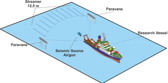
3.1 2D reflection seismic Acquisition ... 37
3.2 2D reflection seismic Processing ... 37
3.3 3D reflection seismic Acquisition ... 39
3.4 3D reflection seismic Processing ... 41
3.5 Multi-Beam Bathymetry and PARASOUND Echo-Sounder data Acquisition and Processing ... 44
References ... 45
4 MANUSCRIPT I ... 46
Abstract ... 47
1 Introduction ... 48
1.1 Tectonic setting of Mt Etna ... 48
1.2 Mt Etna’s eastern flank and its slope instability ... 50
1.3 Objectives ... 52
2 Methods ... 53
3 Results ... 54
3.1 Riposto Ridge ... 54
3.2 Basins at the toe of the continental margin... 56
3.3 The Amphitheatre and the Valle Di Archirafi ... 60
3.4 Timpe Plateau and Catania Canyon ... 62
4 Discussion ... 64
4.1 The architecture and limits of the continental margin ... 64
4.2 Coupling of volcano flank gliding and continental margin spreading ... 66
4.3 Sedimentary- and tectonic systems at the toe of the continental margin ... 69
5 Conclusions ... 70
6 Literature ... 71
5 MANUSCRIPT II ... 73
Abstract ... 74
1 Introduction ... 75
2 Methods: 3D Seismic Acquisition and Processing ... 79
3 Results ... 80
3.1 Seafloor Morphology of the 3D Cube Area ... 80
3.2 Sub-seafloor structure in the area covered by the 3D Cube ... 81
3.3 The Valle di Archirafi ... 84
3.4 The transition of Valle di Archirafi towards the structural high ... 85
3.5 The structural high and the adjacent steep headwall of the amphitheater ... 86
3.6 The substrate at the structural high ... 88
4 Discussion ... 89
4.1 Sediment and debris deposition ... 89
4.2 Tectonic controls on the Valle di Archirafi and the structural high ... 90
4.3 Relevance of the Valle di Archirafi and the structural high in the regional tectonic context .. 92
4.4 Hazard potential of the observed extension and resulting instability ... 93
5 Conclusions ... 94
6 References ... 95
7 Appendix ... 97
6 MANUSCRIPT III ... 99
7 Conclusions and Outlook ... 110
7.1 Conclusions ... 110
7. 2 Outlook ... 114
8 Acknowledgements ... 116
9 Curriculum Vitae ... 117
Outline of the Thesis
Chapter 1 introduces the survey area at Mt Etna. General information on volcano flank- and continental margin instability are presented. In addition, the tectonic setting, the geology and the flank instability at Mt Etna are described.
Chapter 2 presents the objectives of this thesis, which include descriptive and process oriented questions.
Chapter 3 gives an insight to the used methods for this thesis. General information on 2D/3D seismics, multi-beam bathymetry and PARASOUND sediment echo-sounder, as well as the acquisition parameters used during RV Meteor Cruise M/86/2 are presented. A short introduction into the processing of the data is given as well.
Chapter 4: Manuscript I - The limits of seaward spreading and slope instability at the continental margin offshore Mt Etna, imaged by high-resolution 2D seismic data (In review at ‘Tectonophysics’)
This chapter includes the analysis of the architecture of the continental margin and the continental toe offshore Mt Etna by means of 2D high-resolution reflection seismic data. The chapter focuses on the different surface and sub-surface structures observed at the continental margin and continental toe offshore Mt Etna. By compiling all data, a new model for the continental margin and volcano flank architecture will be introduced in this chapter.
Chapter 5: Manuscript II - High-Resolution 3D seismic imaging of spreading and gravitational instability next to a giant amphitheater headwall at the continental margin offshore Mt Etna, Italy (in preparation for submission to ‘Geochemistry; Geophysics, Geosystems’)
This chapter focusses on the 3D P-Cable cube acquired at the central continental margin offshore Mt Etna. It includes the analysis of seafloor morphology, as well as the subsurface sedimentary and tectonic processes. The chapter will give insights into the tectonic control of the Valle di Archirafi and the structural high at the prominent amphitheater-like structure off Mt Etna. In addition, the dataset is evaluated in its regional context.
Chapter 6: Manuscript III - Evidence for landslides offshore Mt. Etna, Italy (Published as Gross, F., Krastel, S., Chiocci, F.L., Ridente, D., Schwab, J., Beier, J., Cukur, D., Winkelmann, D. (2014) New implications on submarine landslides offshore Mt. Etna, Italy. In: Submarine mass movements and their consequences (eds: Krastel et al). Advances in Natural and Technological Hazards Research, 37, 307- 316.)
This chapter focusses on mass transport deposits on the continental margin east off Mt Etna. A new distribution map of submarine mass transport deposits is presented. Another topic of this chapter is the
falsification of the theory by Billi et al. [2008] that the 1908 tsunami was caused by a landslide.
Furthermore, the theory of volcanic tremor and coherent seismicity as a possible trigger mechanism for submarine landslides offshore Mt Etna will be introduced based on the analysis of sediment cores,.
Chapter 7 summarizes the outcome of this thesis and gives an outlook for potential future work at the continental margin offshore Mt Etna.
1 Introduction
1.1 Motivation
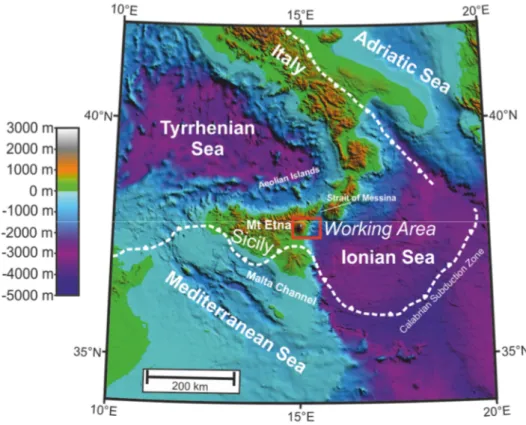
Southern Italy is one of most active seismic regions in Europe [e.g. Orecchio et al. 2014]. This seismic activity is expressed by numerous deep to shallow earthquakes, occurring in the Calabrain Arc at the transition of the Tyrrhenian- and the Ionian Sea [Monaco and Tortorici, 2000] (Fig. 1). Especially the occurrence of large magnitude earthquakes like the 1693 [e.g. Tinti et al. 2001], 1783 [e.g. Jacques et al. 2001] and 1908 earthquake with high numbers of causalities underline the hazardous potential of these ruptures. The 1908 Messina Earthquake (Ms=7.3; 80,000 casualties) and its ensuing tsunami (~2000 causalities) [Baratta, 1910], is known as the most devastating tsunami in historical times striking the Italian coastline [Tinti et al. 1999; Billi et al. 2008]. This event is of major interest, as it is still uncertain, whether a plate boundary rupture at the seafloor or a submarine landslide triggered the tsunami [e.g. Billi et al. 2008; Argnani et al. 2009; Favalli et al. 2009]. In addition to a high seismicity, the area is strongly affected by volcanism in the Tyrrhenian Sea (Aeolian Islands) and the volcanism of Mount Etna on the Sicilian mainland (Fig. 1).
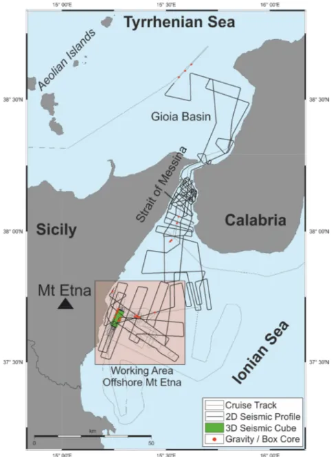
Figure 1: Sicily is located between the Tyrrhenian- and the Ionian Sea. It is separated from the Italian mainland by the Strait of Messina. The working area of this thesis is located offshore Mt Etna, which is Europe’s largest active volcano and piles up to a height of 3323 m a.s.l. The red box marks the working area (Fig. 2). (Projection: Universal Transverse Mercator (UTM))
Mt Etna is known as Europe’s largest and one of the most active volcanoes, worldwide. It piles up to a recent height of 3323 m a.s.l. and established its edifice ~500 kyr ago [Branca et al. 2004] on continental crust directly on the coastline of eastern Sicily [e.g. Gvirtzman and Nur 1999; Doglioni et al. 2001].
First settlements in direct vicinity to Mt. Etna were established in pre-roman times, as the fertile volcano flank offered outstanding quality for farmland and agriculture. Over the past 3000 years the region around Mt Etna developed to a densely populated area. The largest city of the region is Catania, home to ~315.000 inhabitants, directly at the southern slope of Mt Etna. Mt Etna is also known to be the cradle of volcanology as the Greek historian Diodorus Siculus first mentioned and described the active volcano in East Sicily ~ 60 BC [Diodorus Siculus in Vogel and Fisher 1888-1906]. A description and summary of historical eruptions of Mt Etna was presented by Branca [2004]. Due to its impressive volcano edifice forming a unique landscape and its cultural significance, the area of Mt Etna was added by the UNESCO to the World Heritage Sites in 2013 [http://whc.unesco.org/en/news/1042 , 25.02.2015].
Figure 2: Mt Etna and its adjacent continental margin (see Fig. 1 for location). Mt Etna’s volcano edifice can mostly be traced onshore. The continental margin is described as a prominent bulge, which cannot be observed north and south of the volcano edifice in the Ionian Sea. (Projection: Universal Transverse Mercator (UTM))
In addition to several eruptions per year [Branca 2004], Mt Etna is known for its edifice instability, as its eastern and southern flanks are slowly gliding towards the Ionian Sea in the east and the Catania Plain in the south [e.g. Borgia et al. 1992] (Fig. 2). In comparison to the well-studied and monitored onshore realm, only little is known about the adjacent continental margin, which is expressed as a morphological bulge in front of Mt. Etna (Fig. 2). Surveying of the continental margin has only started
~10 years ago [Marani et al. 2004; Argnani and Bonazzi 2005; Pareschi et al. 2006; Chiocci et al.
2011; Argnani et al. 2013]. It is still unclear, if the continental margin is affected by the slope instability, observed at Mt Etna, or the continental margin is an important precursor for this movement. This lack of information is the motivation of this thesis. Providing a description and explaining the situation of the continental margin and its bulging by means of high-resolution hydro/seismo-acoustic and geological data is the main objective of this dissertation.
1.2 Volcanic Flank and Continental Margin instability
In order to understand the complex geologic, tectonic and geodynamic setting at Mt Etna, general volcano flank instability and continental margin instability have to be considered. Mt Etna is a unique type of volcano, as it sits on top of continental curst; volcanic activity is characterized by plinian eruptions at its strato volcano edifice and fissure type eruptions at the volcano flanks for the past ~40 kyr [Branca 2004]. No comparable setting is known worldwide. However, the general effects and precursors for volcano instability [e.g. McGuire 1996 and references therein] and continental margin [e.g. Winker and Edwards 1983; Morley et al. 2011; Peel 2014] instability were studied during the last decades and some of them can be applied to the setting at Mount Etna.
1.2.1 Volcanic Flank instability
After the 1980 Mt St. Helens eruption [Christiansen and Peterson 1981], which might have been triggered by a massive landslide [Lipman and Mullineaux, 1981], volcano instability of large scale volcano edifices and associated geo-hazards are well known. Many studies at different volcanoes like the Hawaiian Island [e.g. Moore et al. 1989], the Canary Island [e.g. Krastel et al. 2001; Mason et al.
2002], the Aeolian Islands [e.g. Kokelaar et al. 1995] and Casita Volcano Nicaragua [e.g. van Wyk de Vries et al. 2000] show the importance of volcano flank instability, as most of the active volcanos reveal sector collapses and instable flanks, worldwide.
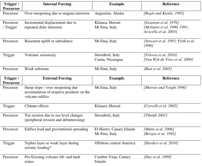
Figure 3: Schematic drawing of possible contributors to volcano edifice structural instability at active volcanos including precursors for flank instability and possible trigger mechanisms for flank failures.
Precursors and trigger mechanisms for volcano flank instability can be divided into endogenic and exogenic factors (Table 1).
Precursors and triggers (Fig. 3) for volcano edifice instability can be classified into internal forcing (endogenic) and external forcing (exogenic) (Table 1) and can generate a volcano edifice instability in periods of weeks to months or thousand to tens of thousands of years [McGuire 1996]. Some of the most prominent endogenic precursors for volcano flank instability at active volcano edifices are slope over-steepening due to magma intrusion [e.g. Begét and Kienle 1992] and incremented displacement due to repeated dyke intrusions [Swanson et al. 1976; McGuire et al. 1990; 1991]. Especially dike intrusions can lead to a lateral flank displacement during fissure type eruptions, affecting volcano flanks like at Mt Etna [Acocella et al. 2003]. Furthermore, exogenic influences on volcano edifice like climate effects [Cervelli et al. 2002] and also toe erosion during sea-level changes can lead to peripheral weakening and debuttressing [e.g. Tibaldi 2001]. Another important mechanism for volcano edifice instability is the weight of the volcano edifice, which is mostly observed at large scale volcanos [e.g.
Münn et al. 2006]. This can lead, like at Mt. Etna, to a gravitational collapse of the entire edifice and result in large-scale spreading and deformation of the volcano edifice [Borgia et al. 1992].
Table 1: Internal and external forcing for volcano flank instability, worldwide (Fig. 2):
Trigger / Precursor
Internal Forcing Example Reference
Precursor Over-steepening due to magma intrusion Augustine, Alaska [Begét and Kienle, 1992]
Precursor / Trigger
Incremental displacement due to repeated dyke intrusion
Kilauea, Hawaii Mt Etna, Italy
[Swanson et al. 1976]
[McGuire et al. 1990, 1991;
Acocella et al. 2003]
Precursor Basement uplift or subsidence Mt Etna, Italy [Stewart et al. 1993; Firth et al.
1996]
Trigger Volcanic seismicity Stromboli, Italy
Casita, Nicaragua
[Telesca et al. 2010]
[Van Wyk de Vries et al. 2000]
Precursor Weak substrate Mt Etna, Italy [Rust et al. 2005]
Trigger / Precursor
External Forcing Example Reference
Precursor Steep slope / over steepening due accumulation of eruptive products on the volcano edifice
Mt Etna, Italy [Murray and Voight 1996]
Trigger Climate effects Kilauea ,Hawaii [Cervelli et al. 2002]
Precursor Toe erosion due to sea level changes (peripheral erosion and debuttressing)
Stromboli, Italy [Tibaldi 2001]
Precursor Edifice load and gravitational spreading El Hierro, Canary Islands Mt Etna, Italy
[Münn et al. 2006]
[Borgia et al. 1992]
Trigger Tephra layer as weak layer during seismic loading*
Offshore central America [Harders et al. 2010]
Precursor Pre-Existing volcano rift- and fault zones
Cumbre Vieja, Canary Islands
[Day et al. 1999]
* Only observed at the continental margin and not at volcano edifice
1.2.2 Continental Margin Instability due to gravity driven processes
The occurrence of large-scale lateral movements at mountain belts lead to the development of the concept of gravity-driven tectonics and deformation [e.g. Bucher 1956; van Bemmelen 1960; Kehle, 1970; Elliott 1976]. It was used to explain the coherence of extensional faults in the up-dip portion and contraction in the down-dip region of sloping landscapes [Peel 2014]. This phenomenon is not only observed in active orogenic complexes. Furthermore, the presence of gravity-driven deformation of sedimentary sequences can be observed at most passive continental margins worldwide [Rowan et al.
2004; Morley et al. 2011; Peel 2014]. Gravity-driven processes can be observed in the range from the meter scale [e.g. Alsop and Marco, 2013] to giant system, which are many kilometers thick and hundreds of kilometers long [Peel et al. 1995].
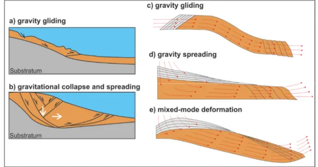
Figure 4: Types of passive continental margin Instability – spreading vs. gliding [modified after Peel et al.
2014] a) gravity gliding is defined as a process, where the system releases its energy parallel to its base by lowering the center of gravity due to a movement along an inclined surface b) gravitational collapse and spreading describes a system in which the system releases its energy due to vertical and lateral thinning of material. In this type, intense internal deformation and related faulting can be observed c) vector displacements during gravity gliding d) vector displacements during gravity spreading e) vector displacements in a mixed-mode deformation, in which spreading and gliding occur in a coherent system.
Two basic modes of gravity driven deformation were described by de Jong and Scholten [1973] and Ramberg [1967; 1977; 1981], as they distinguish between gravity gliding and gravity spreading. Gravity gliding is classified by a system that releases its energy by lowering the center of gravity due to movement along an inclined surface [Peel 2014]; the internal structure of the sediments stays relatively intact. In this case, the system’s energy is released parallel to the base (Fig. 4). Compressional features can be observed at the distal extends of such systems [Peel 2014] (Fig. 4). Gravity spreading is described by a system that releases its gravitational energy due to thinning of the material [Peel 2014]. The energy released by this process is mostly transferred to faulting and deformation. This phenomenon leads to the
strong overprint of extensional faults at continental margins, as the energy releases its energy perpendicular to the base (Fig. 4). In addition a mixed-mode deformation may be observed, where the continental margin is affected as well by gliding due to an inclined surface as spreading due its internal gravitational deformation [Peel 2014] (Fig. 4). In this case, the energy is released parallel and perpendicular to the base (Fig. 4). The definition by Peel [2014] does not distinguish between the lithology and rheology, as it can be applied to brittle, ductile, viscous or plastic material behavior.
Whereas brittle deformation will lead to faulting, ductile deformation will be expressed by folding.
The processes of gravity gliding and spreading are relatively slow processes [Peel 2014] affecting the continental margin. Hence, they differ from massive mass transport events, which are faster events and do have a higher hazardous potential. However, gravity gliding and spreading on continental margins can lead to over-steepening and sediment weakening, which in turn can be a preconditioning factor for sudden failures and mass wasting on continental margins.
1.3 Tectonic setting and Geologic Evolution of Mount Etna
1.3.1 The Tectonic Setting at Mount Etna
Mt Etna, Europe’s largest volcano, rises to a height of 3323 m (Fig. 2). The composite volcanic edifice sitting on top of continental crust [Gvirtzman and Nur 1999] is highly active with an eruption history of
~500 kyr [Branca and Del Carlo 2004; Branca et al. 2004]. Its recent volcanic unrest is documented by several eruptions per year during the past decades [Branca and Del Carlo 2004].
Figure 5: The geodynamic setting of Sicily and Calabria. The Calabrian subduction zone is characterized by a complex subduction. Between the two slabs of the Calabrian Subduction zone, a window opens due to oblique subduction. At this window, Mt Etna established on top of continental crust in East Sicily [modified after Doglioni et al. 2012].
Mt Etna’s geological setting is characterized by the complex compressional tectonics of the Appenine- Maghrebian Fold and Thrust Belt to the south (Fig. 6), and the northwest dipping Calabrian subduction zone to the southeast [e.g. Doglioni et al. 2001; Doglioni et al. 2012] (Figs. 1, 5, 6). The Malta Escarpment (Figs. 5, 6), a large northward trending crustal discontinuity between eastern Sicily’s continental crust and the oceanic crust making up the Ionian Sea, is a prominent morphological feature at the seafloor. It can be traced southward and passes east of the Maltese Islands [Lentini et al. 2006;
Argnani and Bonazzi, 2005], thereby affecting the subduction regime underneath Calabria (Figs. 5, 6) [e.g. Gvirtzman and Nur 1999; Argnani and Bonazzi 2005]. Because of its regional importance as a deep-seated fault, a link between the Malta Escarpment and Mt Etna’s edifice has been proposed [Rust
and Kershaw, 2000]. However, the complex structure and morphology of the continental margin (Fig.
6) makes it difficult to trace the Malta Escarpment as far north as Mt Etna’s coastal offshore extension, and into the onshore volcanic edifice [Argnani and Bonazzi 2005; Nicolich et al. 2000].
Figure 6: Overview map of the geographical setting of Sicily and Tectonic map of East Sicily modified after Argnani [2014]. Sicily is separated from the Italian mainland by the Strait of Messina, which opens towards the Ionian Sea east of Sicily. PFS=Pernicana-Provenzana-Fault-System, TFS=Timpe-Fault-System, SFS=Southern-Fault-System, AMTB=Appenine-Maghrebian Fold and Thrust Belt. The working area of this thesis is marked by a red box.
The NNE trending right-lateral Scilia-Regusa fault system, heading towards Mt Etna at the western boundary of the Hyblean Plateau (Fig. 6), was also invoked to explain the location of Mt Etna [e.g. Lo Guidice and Rasà 1992]. Furthermore, recent interpretations based on refraction and reflection seismic data favor the existence of a distinct southeast trending Subduction Transform Edge Propagator Fault (STEP-Fault), passing by Mt Etna’s northern flank (Figs. 5, 6) [Polonia et al. 2012; Gallais et al. 2013;
Gallais et al. 2014]. Such a fault is required to delimit the retreating Calabrian subduction front towards the southwest, and opening an asthenospheric window at sub-lithospheric depths. The proposed STEP- fault is somewhat oblique to the Malta Escarpment (Figs. 5, 6) [Gallais et al. 2013]. However, Argnani [2014] does not find indications for a distinct near-surface STEP-fault in a dense grid of seismic lines from offshore eastern Sicily. Instead, he suggests a 20-30 km wide corridor of SSE trending faults (Fig.
6) affecting the entire area from Alfeo Seamount to Sicily (Fig. 6) to be the surface expression of a deep crustal-scale structure, controlling the regional tectonics in this area [Argnani 2014]. Argnani [2014]
bases his interpretation on a series of asymmetric half-grabens, bound to eastward dipping normal faults
[Hirn et al. 1997; Nicolich et al. 2000; Bianca et al. 1999, Argnani and Bonazzi, 2005]. These normal faults are proposed to have generated paleo-earthquakes like the 1693 Catania event [Bianca et al. 1999;
Argnani et al. 2012].
The entire region around Mt Etna is seismically highly active [Orecchio et al. 2014] (Fig. 7). Large earthquakes like the disastrous Messina 1908 event [e.g. Pino et al. 2009] occurred in the Strait of Messina north of Mt Etna. Furthermore, deep (20-30 km) compressive earthquakes, probably related to thrusting in the Appennine-Maghrebian Thrust Belt, have been recorded close to the volcano [Lavecchia et al. 2007]. Another set of seismic events (hypocenter depths <10km) were observed underneath the eastern flank of Mt Etna. This small scale variation in location and kinematics of seismic events leads to the interpretation that the stress field underneath Mt Etna is highly heterogeneous [Cocina et al.
1997].
Figure 7: Epicenter locations of earthquakes duration magnitude Md ≥ 2.5 in Sicily and Calabria between January 1997 and May 2011 [Orecchio et al. 2014] a) Seismic stations in Southern Italy b) Seismicity from 0 to 30 km depth. c) Seismicity from 30 to 70 km depth. d) Seismicity from 70 to 350 km depth. Especially shallow seismic activity can be observed in the area at M Etna and its offshore continental margin.
1.3.2 The Geologic Evolution of Mount Etna
Compared with Earth’s History, the ~500 kyr ongoing eruptive history, Mt. Etna can be characterized as a relatively young volcano [Branca et al. 2004]. It reveals different types of volcanism and coherent changes in its mineralogical expression over time; the volcano is still active.
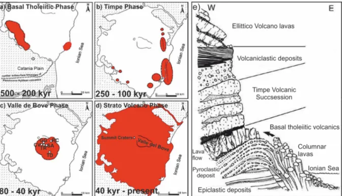
The first period of Mt. Etna’s eruptive history (~500-200 kyr BP) is characterized as a dispersed fissure- type volcanism with a tholeiitic affinity [Branca et al. 2004]. The areal extent of this proto-volcano is described as the northward extension of the Plio-Pleistocene Hyblean volcanism, which extended northwards to the Etnean region (Fig. 8a).
Figure 8: Evolutionary stages of Mt Etna during the last ~500 kyrs [modified after Branca et al. 2004] a) Basal Tholeiitic phase ~500-200 kyr b) Timpe phase ~250-100 kyr c) Valle del Bove volcanos phase ~80-40 kyr TR = Trifoglietto, GG = Giannicola Grande, SA = Salifizio, CV = Cuvigghiuni , RC = Rocche, TD = Tardeira d) Strato volcano phase <40 kyr. e) Schematic drawing of the volcanic succession outcropping at the Acireale Timpa fault [Branca et al. 2004]
The second phase of volcanism (~250-100 kyr BP) is defined by the onset of the Timpe eruptive activity, which concentrates along the Ionian coast at the NNW-SSE oriented Timpe Fault System; this period of activity did not build up major edifices (Fig. 8b). The first volcanic edifices, expressed as the nested volcano centers Tardeira and Rocche, were established during the Valle del Bove Crater Phase (80-40 kyr BP) by an eastward shift of the volcanism (Fig. 8c). A strong variation of the plumbing system created the southern Trifoglietto as well as the Giannicola Grande, Salifizio and Cuvigghiuni craters (Figs. 8, 9). The largest, and recently observable strato-volcano edifice is the Ellittico, which was created
during the stabilization of the plumbing system at Mt Etna and makes up the bulk of the present edifice.
This phase was terminated with four major caldera forming plinian eruptions at ~15 kyr BP [all after Branca et al. 2004].
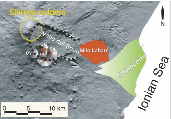
Figure 9: Valle de Bove scar and the Chiancone Fanglomerate, which was so far only mapped onshore. TR
= Trifoglietto, GG = Giannicola Grande, SA= Salifizio, CV = Cuvigghiuni , TP = Tripodo [Calvari et al.
2004]
During the Holocene, the Mongibello volcano established on top of the ancient volcanic edifices. Its eruptive material covers an area of at least 85% of the recent volcano edifice and generated the recent appearance of Mount Etna. A major sector collapse, which created the Valle Del Bove scar, occurred
~8000 yr ago [Calvari et al. 2004]. The debris created by this collapse is known as the Chiancone fanglomerate, which can mostly be traced onshore directly adjacent to the Ionian coastline [Calvari et al. 2004].
1.3.3 Volcano Edifice Instability at Mt Etna’s eastern flank
Mt Etna’s flank instability, first described in the early 1990’s as gravitational instability by Borgia et al.
[1992], is one of the best-monitored and studied examples for volcano flank instability around the world.
In the following years, evidence for both, episodic and continuous flank movement was reported [e.g.
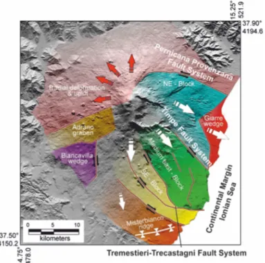
Froger et al. 2001, Acocella et al. 2003, Bonforte and Puglisi 2003]. With the help of a dense network of GPS and geodetic stations [Lundgren et al. 2003; Puglisi et al. 2008; Bonforte et al. 2009; Neri et al. 2009], gas monitoring [Neri et al. 2007; Bonforte et al. 2013], and geologic fieldwork [Groppelli and Tibaldi 1999; Neri et al. 2004], it was possible to locate and characterize the instability of Mt Etna’s eastern flank. The anatomy of the flank and related fault systems were assessed by means of Permanent Scatters analysis, which were used to characterize the main kinematic domains of the flank [Bonforte et al. 2011].
The northern boundary of the moving flank is described as the left lateral Pernicana-Provenzana Fault (Figs. 10, 11, 12) with a continuous horizontal displacement of ~2.,8 cm/a [Bonforte and Puglisi 2003]
that may accelerate during volcanic activity [Bonforte et al. 2007]. The Pernicana-Provenzana Fault system represents the fault system with the highest set of displacements at the edifice of Mt Etna (Fig.
10).
Figure 10: GPS Displacement of selected stations at the eastern and southern flank of Mt. Etna. The vectors represent the total displacements between 1993 and 2006 recorded at selected benchmarks (located at the beginning of each vector arrow) of the GPS network. Highest displacements can be observed at the northern region at the Pernicana-Provenzana Fault system at Mt Etna’s eastern flank. PFS = Pernicana-Provenzana Fault System, TFS = Timpe Fault System, TMF=Tremestieri Fault, TF=Trecastagni Fault [Acocella and Puglisi 2013].
Figure 11: a) Road at the westernmost portion of the Pernicana-Provenzana Fault at Mt Etna’s northern flank on November 12th, 2002. Total horizontal displacement of the fractures is >1.25 m, with a vertical component of ~0.5 m [Neri et al. 2004]. b) The eastern extends of the Pernicana-Provenzana Fault at the A18 Catania Messina Highway. Total vertical displacement at the border of the highway, 0.33 m (of which 0.05 m is related to movement through December 22nd 2002 and 0.28 m is due to previous episodes since 1971, when the highway was constructed) [Neri et al. 2004]
The Timpe Fault System (Figs. 10, 12) separates the NE-Block to the Medium East Block and is well documented by geodetic and InSAR measurements onshore (Fig. 12) [Bonforte et al. 2011]. The southern boundary (Fig. 10) of the moving flank is only constrained by InSAR measurements and Soil Gas emissions and is described by the faults of the Tremestieri-Trecastagni Fault System (Fig. 10) [Froger et al. 2001; Bonforte et al. 2013].
Figure 12: Main Kinematic domains at the edifice of Mt Etna [modified after Bonforte et al. 2011]. Northern boundary of the moving flank: Pernicana-Provenzana Fault System. Southern boundary of the moving flank: Tremestieri-Trecastagni Fault System. The Timpe Fault System can be observed at the central part of Mt Etna’s eastern flank.
1.3.4 Continental Margin Instability offshore Mt Etna
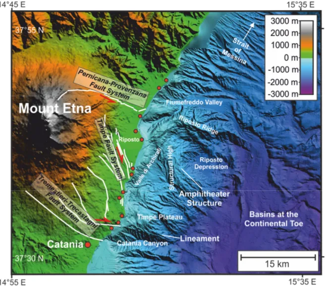
Mt Etna established its edifice directly at the Ionian coastline of eastern Sicily. In comparison to the Ionian continental margin north and south of the volcano edifice, a clear bulging and extension can be observed at the continental margin directly in front of Mt Etna by its morphological expression (Fig. 13) [Chiocci et al. 2011]. In contrast to the well-studied onshore volcano edifice of Mt Etna [e.g. Bonforte et al. 2011], only few information is available concerning the continental margin offshore east of Mt Etna. A first multi-beam bathymetric map of the Ionian Sea illustrated the major morphologic features in the area off Mt Etna [Marani et al. 2004]. The first detailed interpretation of the continental margin’s seafloor morphology was carried out by Chiocci et al. [2011]. Next to deeply incised valleys and gullies, a prominent bulge, between Fiumefreddo Valley and Catania Canyon (Fig. 13), was recognized. This bulging of the continental margin can only be observed directly in front of Mt Etna and cannot be traced further north or south [Chiocci et al. 2011; Argnani et al. 2013].
Argnani et al. [2013] interpret the bulge at the continental margin as the northernmost extent of the Hyblean Foreland, which is the onshore region south of Catania (Fig. 1). However, Chiocci et al. [2011]
interpret the bulge to be a response to intrusive inflation of a pre-Etnean continental margin. By using high-resolution multi-beam bathymetry, Chiocci et al. [2011] proposed the idea of an upslope propagating instability, caused by a large scale mass wasting event offshore Mt. Etna, creating a prominent amphitheater (Fig. 13) offshore the village of Riposto (Fig. 13). Reflection seismic data indicate that the offshore area around the volcano is dominated by extensional faulting with thrust faults close to the coast and towards the distal extends of the continental margin [Argnani et al. 2013].
However, Argnani et al. [2013] interpret the bulge to be generated rather by thrusting than to a simple inflation due to magmatic intrusion related to Mt Etna. So far it was not possible to determine the limits of instability, affecting the continental margin [Argnani et al. 2013].
Figure 13: Mt Etna and its adjacent continental margin. The continental margin is characterized by bulging, what cannot be observed at the continental margins north and south of Mt Etna’s edifice. The continental margin is strongly overprinted by channels and gullies. The continental margin can be subdivided into three major regions. The southern region is characterized by the Timpe Plateau, which is strongly overprinted by gullies and channels. It is terminated towards the south by Catania Canyon. The central region shows the morphological expressions of the funnel shaped Valle di Archirafi, a structural high with prominent ridges and a massive amphitheater structure with its enclosed Riposto Depression. The northern region is marked by the E-W trending anticline of Riposto Ridge. In front of the continental margin, the seafloor morphology flattens abruptly. In this region, large sedimentary basins can be observed. The entire continental margin and its structures will be described and examined in detail in chapters 5, 6 and 7. The digital elevation model was created by using the SRTM dataset [Farr et al. 2007], the MaGIC dataset [Chiocci and Ridente 2011] and the bathymetry, acquired during RV Meteor Cruise M86/2 – Map shown with UTM Projection.
1.3.5 Recent studies on the origin of volcano edifice and continental margin instability on- and offshore Mt Etna
Instability can be driven by magma pressure, lack of buttressing support, loading of the edifice on a weak basement, increasing pore pressure associated with volcanism, dike emplacement, and/or tectonic stress [e.g. Voight and Elsworth 1997; McGuire 1996]. Explaining flank instability of Mt Etna is particularly challenging as deformation due to magma overpressure reaches its maximum at the summit, whereas the larger subsidence and seaward movements are recorded along the coast [Acocella and Puglisi 2013]. Moreover, displacement measurements are yet limited to the onshore part of the volcano, while the continental margin, affected by the volcano buildup, lies offshore in the Ionian Sea. Recent hypotheses that have been brought forward to explain instability of Mt Etna’s eastern flank include:
i) Magmatically induced: Flank dynamics have been interpreted as a passive effect of gravity instability and magma intrusion [e.g. Bonforte and Puglisi 2003]. More recently, Le Corvec et al. [2014]
used analogue modelling to shed light on the complex interplay interaction of magmatism, flank instability, and tectonic activity. Their model not only explains the different spatial displacement rates, but also temporally variable activity of the Timpe Fault System before, during and after eruptions.
ii) Missing mass: Chiocci et al. [2011] analyze bathymetric data offshore Mt Etna. The authors find that the entire continental margin is affected by large deformations that develop from the base of the slope up to the shoreline. Moreover, both submarine instability and subaerial flank sliding are bounded by two regional tectonic lineaments. Hence, they propose that continental margin instability drives the eastern flank’s seaward movement.
iii) Basement landslide: Nicolosi et al. [2014] use magnetic data to model the non-volcanic strata that is underlying Mt Etna. Their results indicate that Mt Etna is growing on a pre-existing basement landslide and the authors show that its eastern flank moves coherently with the underlying landslide.
References
Acocella, V., Behncke, B., Neri, M., D'Amico, S., 2003. Link between major flank slip and 2002–2003 eruption at Mt. Etna (Italy). Geophysical Research Letters 30. 2286. DOI:10.1029/2003GL018642
Acocella, V., Puglisi, G., 2013. How to cope with volcano flank dynamics? A conceptual model behind possible scenarios for Mt. Etna. Journal of Volcanology and Geothermal Research 251. 137–148. DOI:10.1016/j.jvolgeores.2012.06.016
Alsop, G.I., Marco, S., 2013. Seismogenic slump folds formed by gravity-driven tectonics down a negligible subaqueous slope. Tectonophysics 605.
48–69.
Argnani, A., Bonazzi, C., 2005. Malta Escarpment fault zone offshore eastern Sicily: Pliocene-Quaternary tectonic evolution based on new multichannel seismic data. Tectonics 24. DOI:10.1029/2004TC001656
Argnani A., Chiocci F.L., Tinti S., Bosman A., Lodi M.V., Pagnoni G., Zaniboni F., 2009. Comment on “On the cause of the 1908 Messina tsunami, southern Italy” by Andrea Billi et al. Geophysical Research Letters 36. L13307.
Argnani, A., Armigliato, A., Pagnoni, G., Zaniboni, F., Tinti, S., Bonazzi, C., 2012. Active tectonics along the submarine slope of south-eastern Sicily and the source of the 11 January 1693 earthquake and tsunami. Natural Hazards Earth System Sciences. 12. 1311–1319.
DOI:10.5194/nhess-12-1311-2012
Argnani, A., Mazzarini, F., Bonazzi, C., Bisson, M., Isola, I., 2013. The deformation offshore of Mount Etna as imaged by multichannel seismic reflection profiles. Journal of Volcanology and Geothermal Research 251. 50–64. DOI:10.1016/j.jvolgeores.2012.04.016
Argnani, A., 2014. Comment on the article “Propagation of a lithospheric tear fault (STEP) through the western boundary of the Calabrian accretionary wedge offshore eastern Sicily (Southern Italy)” by Gallais et al., 2013 Tectonophysics. Tectonophysics 610. 195–199.
DOI:10.1016/j.tecto.2013.06.035
Baratta, M., 1910. La Catastrofe Sismica Calabro-Messinese (28 Dicembre 1908). Soc. Geogr. Ital., Rome. 496.
Begét, J. E., Kienle, J., 1992. Cyclic formation of debris avalanches at Mount St Augustine volcano. Nature 356. 701–704. DOI: 10.1038/356701a0 Bianca, M., Monaco, C., Tortorici, L., Cernobori, L., 1999. Quaternary normal faulting in southeastern Sicily (Italy): a seismic source for the 1693
large earthquake. Geophysical Journal International 139. 370–394. DOI:10.1046/j.1365-246x.1999.00942.x
Billi A., Funiciello R., Minelli L., Faccenna C., Neri G., Orecchio B., Presti D., 2008. On the cause of the 1908 Messina tsunami, Southern Italy.
Geophysical Research Letters 35; L06301 DOI:10.1029/2008GL033251
Bonforte, A., Puglisi, G., 2003. Magma uprising and flank dynamics on Mount Etna volcano, studied using GPS data (1994–
1995). Journal of Geophysical Research 108. 2153. DOI:10.1029/2002JB001845.
Bonforte, A., Branca, S., Palano, M., 2007. Geometric and kinematic variations along the active Pernicana fault: Implication for the dynamics of Mount Etna NE flank (Italy). Journal of Volcanology and Geothermal Research 160. 210–222. DOI:10.1016/j.jvolgeores.2006.08.009 Bonforte, A., Gambino, S., Neri, M., 2009. Intrusion of eccentric dikes: The case of the 2001 eruption and its role in the dynamics of Mt. Etna
volcano. Tectonophysics 471. 78–86. DOI:10.1016/j.tecto.2008.09.028
Bonforte, A., Guglielmino, F., Coltelli, M., Ferretti, A., Puglisi, G., 2011. Structural assessment of Mount Etna volcano from Permanent Scatterers analysis. Geochemistry Geophysics Geosystems 12. DOI:10.1029/2010GC003213
Bonforte, A., Federico, C., Giammanco, S., Guglielmino, F., Liuzzo, M., Neri, M., 2013. Soil gases and SAR measurements reveal hidden faults on the sliding flank of Mt. Etna (Italy). Journal of Volcanology and Geothermal Research 251. 27–40. DOI:10.1016/j.jvolgeores.2012.08.010 Borgia, A., Ferrari, L., Pasquarè, G., 1992. Importance of gravitational spreading in the tectonic and volcanic evolution of Mount Etna. Nature 357.
231–235. DOI:10.1038/357231a0
Branca, S., Del Carlo, P., 2004. Eruptions of Mt Etna during the past 3,200 years: a revised compilation integrating the historical and stratigraphic records. Bonaccorso, A., Calvari, S., Coltelli, M., Del Negro, C., Falsaperla, S. (Eds.). Mt. Etna: Volcano Laboratory. Geophysical Monograph Series 143. American Geophysical Union, Washington, D.C.. 1–27.
Branca, S., Coltelli, M., Groppelli, G., 2004. Geological evolution of Etna volcano. Bonaccorso, A., Calvari, S., Coltelli, M., Del Negro, C., Falsaperla, S. (Eds.), Mt. Etna: Volcano Laboratory. Geophysical Monograph Series, 143. American Geophysical Union, Washington, D.C.. 49–63.
Bucher, W.H., 1956. Role of gravity in orogenesis. Geological Society of America Bulletin. 67, 1295–1318.
Calvari, S., Tanner, L. H., Groppelli, G., Norini, G., 2004. Valle del Bove, eastern flank of Etna Volcano: A comprehensive model for the opening of the depression and implications for future hazards. Alessandro Bonaccorso, Sonia Calvari, Mauro Coltelli, Ciro Del Negro und Susanna Falsaperla (Eds.): Mt. Etna: Volcano Laboratory, Bd. 143. Washington, D. C: American Geophysical Union (Geophysical monograph series). 65–75.
Cervelli, P., Segall, P., Johnson, K., Lisowski, M., Miklius, A., 2002. Sudden aseismic fault slip on the south flank of Kilauea volcano. Nature 415.
1014–1018. DOI: 10.1038/4151014a
Chiocci, F.L., Coltelli, M., Bosman, A., Cavallaro, D., 2011. Continental margin large-scale instability controlling the flank sliding of Etna volcano.
Earth and Planetary Science Letters 305. 57–64. DOI:10.1016/j.epsl.2011.02.040
Chiocci, F.L., Ridente, D., 2011. Regional-scale seafloor mapping and geohazard assessment. The experience from the Italian project MaGIC (Marine Geohazards along the Italian Coasts). Marine Geophysical Research 32. 13–23. DOI: 10.1007/s11001-011-9120-6
Christiansen, R.I., Peterson, D.W., 1981. Chronology of the 1980 eruptive activity. In: Lipman, P. W. & Mullineaux, D. R. (Eds) The 1980 eruptions of Mount St Helens. US Geological Survey Professional Paper 1250. 17-30.
Cocina, O., Neri, G., Privitera, E., Spampinato, S., 1997. Stress tensor computations in theMount Etna area (Southern Italy) and tectonic implications.
Journal of Geodynamics 23. 109–127. DOI:10.1016/S0264-3707(96)00027-0
Day, S.J., Carracedo, J.C, Guillou, H., Gravestock, P., 1999. Recent structural evolution of the Cumbre Vieja volcano, La Palma, Canary Islands:
volcanic rift zone reconfiguration as a precursor to volcano flank instability? Journal of Volcanology and Geothermal Research 94. 135–
167. DOI: 10.1016/S0377-0273(99)00101-8
De Jong, K.A., Scholten, R., 1973. Preface. In: De Jong, K.A., Scholten, R. (Eds.), Gravity and Tectonics. John Wiley and Sons, New York. ix–xviii.
Doglioni, C., Innocenti, F., Mariotti, G., 2001. Why Mt Etna?. Terra Nova 13. 25–31. DOI:10.1046/j.1365-3121.2001.00301.x
Doglioni, C., Ligi, M., Scrocca, D., Bigi, S., Bortoluzzi, G., Carminati, E., et al., 2012. The tectonic puzzle of the Messina area (Southern Italy):
Insights from new seismic reflection data. Scientific Reports 2. DOI: 10.1038/srep00970
Elliott, D., 1976. The energybalance and deformation mechanisms of thrust sheets. Philosophical Transactions of the Royal Society A 283. 289–312.
Farr, T. G., Rosen, A., Caro, E., Crippen, R., Duren, R., Hensley, S., Kobrick, S., Rodriguez, E., Roth, L., Seal, D., Shaffer, S., Shimada, J., Umland, J., Werner, M., Oskin, M., Burbank, D., Alsdorf, D., 2007. The Shuttle Radar Topography Mission. Reviews of Geophysics 45.
DOI:10.1029/2005RG000183
Favalli, M., Boschi, E., Mazzarini, F., Pareschi, M.T., 2009. Seismic and landslide source of the 1908 Straits of Messina tsunami (Sicily, Italy).
Geophysical Research Letters 36. DOI: 10.1029/2009GL039135.
Firth, C., Stewart, I., McGuire, W.J., Kershaw, S., Vita-Finzi, C., 1996, Coastal elevation changes in eastern Sicily: implications for volcano instability at Mount Etna. Geological Society, London, Special Publications 110. 153–167. DOI:10.1144/GSL.SP.1996.110.01.12 Froger, J.L., Merle, O., Briole, P., 2001. Active spreading and regional extension at Mount Etna imaged by SAR interferometry. Earth and Planetary
Science Letters 187. 245–258. DOI:10.1016/S0012-821X(01)00290-4
Gallais, F., Graindorge, D., Gutscher, M.A., Klaeschen, D., 2013. Propagation of a lithospheric tear fault (STEP) through the western boundary of the Calabrian accretionary wedge offshore eastern Sicily (Southern Italy). Tectonophysics 602. 141–152. DOI:10.1016/j.tecto.2012.12.026 Gallais, F., Graindorge, D., Gutscher, M.A., 2014. Reply to comment on the article “Propagation of a lithospheric tear fault (STEP) through the western boundary of the Calabrian accretionary wedge offshore eastern Sicily (Southern Italy)” by Gallais et al., 2013 Tectonophysics.
Tectonophysics 610. 200–203. DOI:10.1016/j.tecto.2013.10.012.
Groppelli, G., Tibaldi, A., 1999. Control of rock rheology of deformation style and sliprate along the active Pernicana fault, Mt. Etna, Italy.
Tectonophysics 305. 521–537. DOI:10.1016/S0040-1951(99)00035-9
Gvirtzman, Z., Nur, A., 1999. The formation of Mount Etna as the consequence of slab rollback. Nature 401. 782–785. DOI:10.1038/44555 Jacques, E., Monaco, C., Tapponnier, P., Tortorici, L., Winter, T., 2001. Faulting and earthquake triggering during the 1783 Calabria seismic
sequence. Geophysical Journal International 147. 499–516. DOI:10.1046/j.0956-540x.2001.01518.x
Harders R., Kutterolf S., Hensen C., Moerz T., Brückmann W., 2010. Tephra layers: A controlling factor on submarine translational sliding?.
Geochemistry Geophysics Geosystems 11 5. 1-18. DOI:10.1029/2009GC002844
Hirn, A., Nicolich, R., Gallart, J., Laigle, M., Cernobori, L., ETNASEIS Scientific Group, 1997. Roots of Etna volcano in faults of great earthquakes.
Earth and Planetary Science Letters 148. 171–191. DOI:10.1016/S0012-821X(97)00023-X
Kehle, K.O., 1970. Analysis of gravity sliding and orogenic translation. Geological Society of America Bulletin 81. 1641–1664.
Kokelaar, P., Romagnoli, C., 1995. Sector collapse, sedimentation and clast population evolution at an active island-arc volcano: Stromboli, Italy.
Bulletin of Volcanology 57. 240–262. DOI:10.1007/BF00265424
Krastel, S., Schmincke, H., Jacobs, C.L., Rihm, R., Le Bas, T.P., Alibés, B., 2001. Submarine landslides around the Canary Islands. Journal Geophysical Research. 106. DOI:10.1029/2000JB900413
Lavecchia, G., Ferrarini, F., De Nardis, R., Visini, F., Barbano, M.S., 2007. Active thrusting as a possible seismogenic source in Sicily (sourthern Italy). Some insights from integrated structural-kinematic and seismological data. Tectonophysics 445. 145–167.
DOI:10.1016/j.tecto.2007.07.007
Le Corvec, N., Walter, T.R., Ruch, J., Bonforte, A., Puglisi, G., 2014. Experimental study of the interplay between magmatic rift intrusion and flank instability with application to the 2001 Mount Etna eruption. Journal of Geophysical Research Solid Earth. DOI: 10.1002/2014JB011224.
Lentini, F., Carbone, S., Guarnieri, P., 2006. Collisional and postcollisional tectonics of the Apenninic-Maghrebian orogen (southern Italy). Dilek, Y., Pavlides, S. (Eds.), Postcollisional Tectonics and Magmatism in the Mediterranean Region and Asia. Special Paper - Geological Society of America 409. 57–81. DOI:10.1130/2006.2409(04)
Lipman, P.W., Mullineaux, D. (Eds.). 1981. The 1980 eruptions of Mount St Helens. US Geological Survey Professional Paper. 1250.
Lo Giudice, E., Rasà, R., 1992. Very shallow earthquakes and brittle deformation in active volcanic areas: the Etnean region as an example.
Tectonophysics 202. 257–268.
Lundgren, P., Berardino, P., Coltelli, M., Fornaro, G., Lanari, R., Puglisi, G., Sansosti, E., Tesauro, M., 2003. Coupled magma chamber inflation and sector collapse slip observed with synthetic aperture radar interferometry on Mt. Etna volcano. Journal of Geophysical Research 108.
2247, DOI:10.1029/2001JB000657.
Marani, M.P., Gamberi, F., Bortoluzzi, G., Carrara, G., Ligi, M., Penitenti, D., 2004. Seafloor bathymetry of the Ionian Sea. In: Marani, M.P., Gamberi, F., Bonatti, E. (Eds.), From Seafloor to Deep Mantle: Architecture of the Tyrrhenian Backarc Basin: Memorie Descrittive della Carta Geologica d'Italia 44. Plate 3. Roma, System Cart.
Masson, D. G., Watts, A.B., Gee, M.J.R., Urgeles, R., Mitchell, N.C., Le-Bas, T.P., Canals, M., 2002. Slope failures on the flanks of the western Canary Islands. Earth-Science Review 57. 1-35. DOIi:10.1016/S0012-8252(01)00069-1
McGuire, W.J., Pullen, A.D., Saunders, S.J., 1990. Recent dyke-induced large-scale block movement at Mount Etna and potential slope failure.
Nature 343. 357-359.
McGuire, W.J., Murray, J.B., Pullen, A.D., Saunders, S.J., 1991. Ground deformation monitoring at Mount Etna; evidence for dyke emplacement and slope instability. Journal of the Geological Society, London 148. 577-583.
McGuire, W.J., 1996. Volcano instability: a review of contemporary themes. Geological Society, London, Special Publications 110. 1–23. DOI:
10.1144/GSL.SP.1996.110.01.01
Monaco, C., Tortorici, L., 2000. Active faulting in the Calabrian arc and eastern Sicily. Journal of Geodynamics 29. 407–424. DOI: 10.1016/S0264- 3707(99)00052-6
Moore, J.G., Clague, D.A., Holcomb, R.T., Lipman, P.W., Normark, W.R., Torresan, M.E., 1989. Prodigious submarine landslides on the Hawaiian Ridge, Journal of Geophysical Research 94. 17. 465-484.
Morley, C.K., King, R., Hillis, R., Tingay, M., Backe, G., 2011. Deepwater fold and thrust belt classification, tectonics, structure and hydrocarbon prospectivity: A review. Earth-Science Reviews 104. 41–91. DOI:10.1016/j.earscirev.2010.09.010
Münn, S., Walter, T.R., Klügel, A., 2006. Gravitational spreading controls rift zones and flank instability on El Hierro, Canary Islands. Geological Magazine 143. 257. DOI: 10.1017/S0016756806002019
Murray, J.B., Voight, B., 1996. Slope stability and eruption prediction on the eastern flank of Mount Etna. Geological Society, London, Special Publications 110.
![Figure 6: Overview map of the geographical setting of Sicily and Tectonic map of East Sicily modified after Argnani [2014]](https://thumb-eu.123doks.com/thumbv2/1library_info/5507803.1686095/21.892.128.758.199.682/figure-overview-geographical-setting-sicily-tectonic-modified-argnani.webp)