1
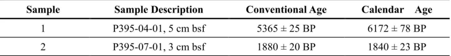
Deep-water sedimentary systems and processes on the continental margin offshore NW Africa
Dissertation
zur Erlangung des Doktorgrades
der Mathematisch-Naturwissenschaftlichen Fakultät der Christian-Albrechts-Universität zu Kiel
vorgelegt von
Wei Li
Kiel, 2017
2
Erster Gutachter:………...Prof. Dr. Sebastian Krastel-Gudegast Zweiter Gutachter:………... Prof. Dr. Christian Berndt Tag der mündlichen Prüfung:………... 17. Juli 2017 Zum Druck genehmigt am:………... 17. Juli 2017
3
Erklärung
Hiermit erkläre ich, dass ich die vorliegende Doktorarbeit selbstständig und ohneZuhilfenahme unerlaubter Hilfsmittel angefertigt habe. Sie stellt, abgesehen von der Beratungdurch meine Betreuer, nach Inhalt und Form meine eigene Arbeit dar. Weder diese noch eineähnliche Arbeit wurde an einer anderen Abteilung oder Hochschule im Rahmen einesPrüfungsverfahrens vorgelegt, veröffentlicht oder zur Veröffentlichung vorgelegt. Fernerversichere ich, dass die Arbeit unter Einhaltung der Regeln guter wissenschaftlicher Praxisder Deutschen Forschungsgemeinschaft entstanden ist.
Kiel, den 28.Mai 2017
Wei Li
4
Abstract
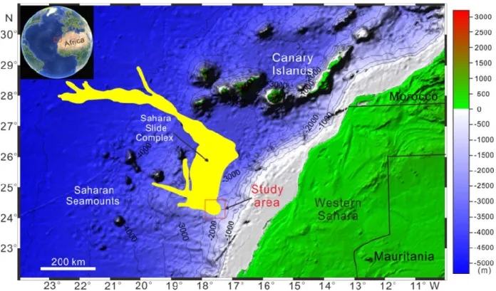
Deep-water sedimentary systems are important components of continental margins. Deep-water sedimentary processes, including gravity-driven downslope and along-slope processes, affect the construction and erosion of continental margins. Various types of deep-water sedimentary systems have been found at the Northwest Africa continental margin, e.g., canyons, mass transport deposits, turbidites, and contourites. It is an ideal laboratory for investigating different deep-water sedimentary processes. Therefore, this thesis focuses on the investigation of deep-water sedimentary processes affecting the Northwest African margin. Two research areas along the NW African margin were chosen: the Western Saharan margin and the Moroccan margin. On the Western Saharan margin, high-resolution multibeam bathymetry, sidescan sonar, sub-bottom profiler, 2D seismic data, and sediment gravity-cores were acquired during RV Maria S.
Merian-Cruise MSM11/2 in 2009 and RV Poseidon-Cruise P395 in 2010. The acquired data allowed a detailed analysis of the upper headwall area of the Sahara Slide Complex and three giant, buried sediment mounds beneath the upper headwall area. On the Moroccan margin, high-resolution multibeam bathymetry data, 2D seismic profiles, and gravity cores were collected during RV Maria S. Merian-Cruise MSM32 in 2013. One focus of this cruise was an in-depth investigation of the Agadir Slide, a mega slide on the Moroccan margin, which was not described before.
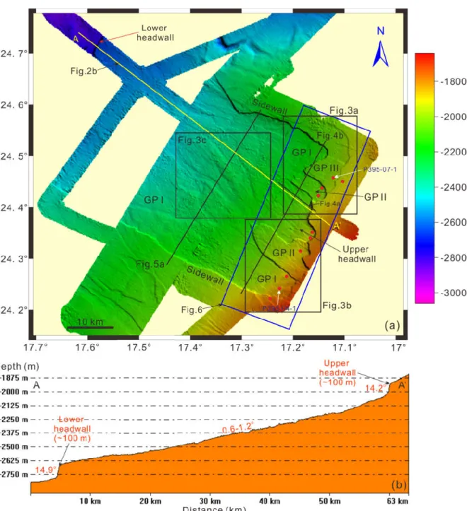
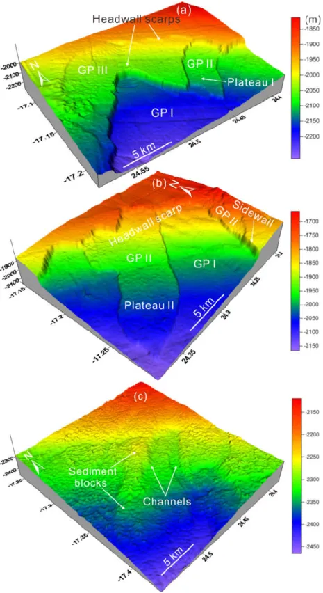
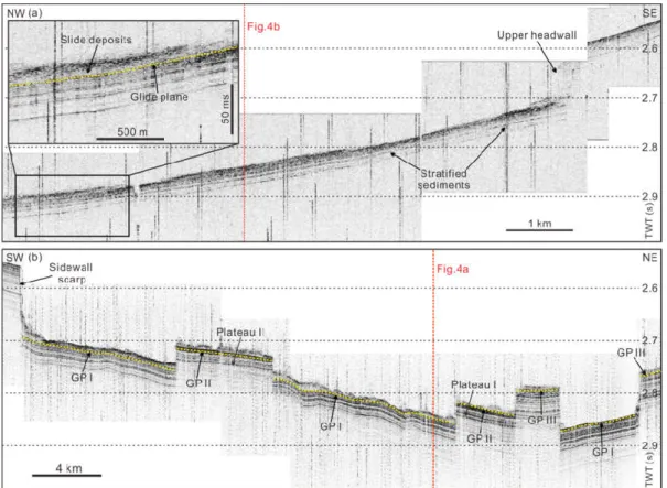
Bathymetric data collected in the source area of the Sahara Slide Complex reveal that the upper headwall area is ~35 km in width and it opens towards the northwest. Numerous morphological features have been discovered in the upper headwall area, including slide scarps, glide planes, plateaus, lobes, slide blocks, and slide debris. Sidescan sonar data provide a higher resolution image of the seafloor morphology and texture on the upper headwall area. Several acoustic terrains have been identified: undisturbed smooth seafloor, eroded smooth glide planes, sediment ridges, crown cracks, slide blocks, and basal striations. These seafloor features were generated by two types of mass movement processes: translational sliding and gravitational spreading along three glide planes at different stratigraphic depths. Volume estimation illustrates that at least 150 km3 of sediments have been displaced, which is sufficient volume to pose a significant tsunamigenic potential, even if occurring in relatively large water depths (~2000 m). The presence of weak layers and sediment layers with high compressibility are considered as the main preconditioning factors for the formation of the slide events in the upper headwall area. The timing of the failure is constrained by dated gravity cores. The failure leading to the formation of the upper headwall area is relatively young (~2 ka), which is much younger than that derived for landslide deposits on the lower reaches of the Sahara Slide Complex, which are dated at 50-60 ka. The young age of the failure contradicts
5
the postulate of a stable slope offshore Northwest Africa during sea-level high stands. Such an observation suggests that submarine-landslide risk along the continental margin of Northwest Africa should be reassessed based on a robust dating of proximal and distal slope failures.
2D seismic data acquired in the upper headwall area allowed the discovery of three giant sediment mounds. These sediment mounds are perpendicular to the continental margin with a predominant SE-NW orientation separated by broad troughs. They all exhibit an elongated geometry, and are at least 24 to 37 km-long and 12 to 17 km-wide. The seismic stratigraphy was established by correlating seismic horizons with published chronostratigraphic information from DSDP Sites 139, 369 and 397. The development processes of these sediment mounds can be divided into three different stages: a) initial growth stage during the Middle Eocene, b) main growth stage during the Early Miocene and, c) maintenance stage during Middle Miocene. The mounds started to grow on a regional unconformity under the interaction of downslope turbidity currents, submarine landslides, and along-slope bottom currents. The sediment mounds finally terminated to grow at the Middle-Late Miocene boundary, indicating a major paleoceanographic change along the Northwest African margin and new depositional patterns established subsequently. The sediment mounds are therefore ideal records of the initiation, intensification, and evolution of bottom currents along the Western Saharan margin. Their inception suggests a time-period (Late Miocene to Middle Miocene) of intense deep-geostrophic activity several orders of magnitude larger than present-day conditions.
The investigations off Morocco were focused on the large-scale Agadir Slide. The Agadir Slide is located south of the Agadir Canyon at a water depth ranging from 500 m to 3500 m with an affected area of ~5500 km2. Bathymetry data illustrate the detailed seafloor morphology of the Agadir Slide, which consists of two headwall areas and two slide fairways. The Agadir Slide enters the Agadir Canyon after passing through the Central slide fairway. The internal architecture of the Agadir Slide is examined in detail based on 2D seismic data. Volume calculations indicate that approximately 340 km3 of sediment were accumulated downslope, twice as much as strata (~170 km3) evacuated from the source areas of the Agadir Slide. This discrepancy points to a highly erosional behaviour of the Agadir Slide along its basal shear surfaces and sidewalls, thereby increasing the volume of the Agadir Slide deposits. Age models based on stratigraphic correlations from five gravity cores indicate an age of ~142 ka for the emplacement of the Agadir Slide. The Agadir Slide developed retrogressively in two phases. Local seismicity and fault activity related to halokinesis likely triggered the Agadir Slide. In addition, salt domes breaching the seafloor acted as major topographic barriers to sediment flow and, as a result, the Agadir Slide neither disintegrated into sediment blocks nor was transformed into turbidity currents. With an age of 142 ka the Agadir Slide cannot be the source for any of the turbidite beds in the Moroccan Turbidite System.
6
Zusammenfassung
Sedimentäre Tiefwassersysteme sind wichtige Bestandteile von Kontinentalhängen.
Sedimentäre Tiefenwasserprozesse, wie gravitativ angetriebene, parallel und senkrecht zum Hang stattfindende Prozesse, beeinflussen den Aufbau und die Erosion von Kontinentalhängen.
Verschiedene Typen von sedimentären Tiefwassersystemen können auf den Kontinentalhängen vor Nordwestafrika gefunden werden. Hierzu gehören zum Beispiel Canyons, Ablagerungen von Hangrutschungen, Turbidite und Contourite. Deshalb ist diese Region ein ausgezeichnetes Untersuchungsgebiet für die Forschung an sedimentären Tiefwassersystemen. In dieser Arbeit liegt der Untersuchungsschwerpunkt daher auf den Prozessen, die auf dem Kontinentalhang vor Nordwestafrika eine wichtige Rolle spielen. Es wurden zwei Untersuchungsgebiete auf dem nordwestafrikanischen Kontinentalhang ausgewählt: Der Kontinentalhang vor der Westsahara und der marokkanische Kontinentalhang. Während der FS Maria S. Merian-Fahrt MSM12/2 (2009) und FS Poseidon-Fahrt POS395 (2010) zum Kontinentalhang vor der Westsahara wurde ein Datensatz bestehend aus hochauflösenden Fächerecholot-, Seitensichtsonar-, Sedimentecholot-, 2D-seismischen und Sedimentschwerelot-Daten aufgezeichnet. Diese Daten ermöglichen eine detaillierte Analyse der oberen Abrisskante des Sahara-Slide-Complexes, sowie von drei riesigen verschütteten Terrainwellen unter dieser Abrisskante. Während der Forschungsfahrt MSM32 (2013) zum marokkanischen Kontinentalhang wurden zudem hochauflösende Fächerecholot- und 2D-seismische Daten aufgezeichnet, sowie Schwerelotkerne genommen. Ein Schwerpunkt dieser Forschungsfahrt war die detaillierte Untersuchung des Agadir-Slides, einer riesigen Hangrutschung auf dem marokkanischen Kontinentalhang, der zuvor noch nicht beschrieben und bearbeitet wurde.
Die bathymetrischen Daten aus dem Ursprungsbereich des Sahara-Slide-Complexes zeigen, dass die obere Abrisskante ~35 km lang und in Richtung Nordwesten einfallend ist. Eine Vielzahl an morphologischen Ausprägungen kann in der Nähe der oberen Abrisskante gefunden werden.
Hierzu gehören: Hangrutschungsabrisskanten, Gleitflächen, Plateaus, Lobi, gerutschte Blöcke, sowie Geröll. Seitensichtsonaraufnahmen liefern eine höhere Auflösung der Meeresbodenmorphologie und des Aufbaus der Abrisskanten. Anhand dieser Methode wurden verschiedene akustische Fazien identifiziert. Hierzu gehören: ungestörter und glatter Meeresboden, erosiv überprägte glatte Gleitflächen, sedimentäre Rücken, Kronenbrüche, gerutschte Blöcke, sowie Grundschrammen. Alle diese Strukturen am Meeresboden wurden von zwei Prozessen der Massenumlagerung erzeugt: Blattgleitung und gravitative Meeresbodenaufweitung entlang dreier Gleitebenen in verschiedenen stratigraphischen Einheiten. Eine Volumenabschätzung zeigt, dass mindestens 150 km3 Sediment umgelagert wurden. Obwohl die Rutschung in relativ hoher
7
Wassertiefe (~2000 m) stattfand, ist die Masse ausreichend, um ein signifikantes Potential für die Entstehung eines Tsunamis darzustellen. Das Auftreten von schwachen Schichten, sowie sedimentären Schichten mit einer hohen Kompressibilität, werden als die wichtigsten Vorbedingungen für das Entstehen einer Rutschung im Bereich der oberen Abrisskante angesehen.
Das Alter der Rutschung wurde mit Hilfe von datierten Schwerelotkernen eingegrenzt. Hieraus ergibt sich, dass die Rutschung, die für die Bildung der oberen Abrisskante verantwortlich ist, relativ jung ist (~2 ka). Dieses Alter ist wesentlich geringer als die im distalen Bereich des Sahara-Slide-Complexes datierten Ablagerungen, die auf 50-60 ka datiert wurden. Dieses junge Alter der Rutschung widerspricht der gängigen Meinung, dass der nordwestafrikanische Kontinentalhang während eines hohen Meeresspiegelstands, wie vor 2 ka, stabil ist. Diese Beobachtung zeigt, dass das Risiko von submarinen Hangrutschungen am Kontinentalhang vor Nordwestafrika, mit der Benutzung von robusteren Datierungen im proximalen und distalen Bereich, neu bewertet werden sollte.
2D-seismische Daten, die im Bereich der oberen Abrisskante aufgezeichnet wurden, ermöglichten in dieser Region die Entdeckung von drei riesigen sedimentären Rücken. Diese sedimentären Rücken sind senkrecht zum Kontinentalhang mit einer Vorzugsrichtung von SO-NW ausgerichtet und durch breite Tröge voneinander getrennt. Die Rücken weisen eine langgestreckte Geometrie auf und sind mindestens 24 bis 37 km lang sowie 12 bis 17 km breit. Die seismische Stratigraphie wurde anhand einer Korrelation von seismischen Horizonten mit publizierten, chronostratigraphischen Informationen aus den DSDP Sites 139, 369 und 397 erstellt. Hieraus folgend kann der Entwicklungsprozess der drei Rücken in drei unterschiedliche Phasen gegliedert werden: a) Initiale Wachstumsphase während des Mittleren Eozäns, b) Hauptwachstumsphase während des Unteren Miozäns und, c) Aufrechterhaltungsphase während des Mittleren Miozäns.
Die Entstehung der Rücken begann mit einer Ablagerung von Turbiditen, Hangrutschungen und hangparallelen Bodenströmungen auf einer regional ausgeprägten Diskordanz. Das Wachstum der sedimentären Rücken wurde an der Grenze zwischen Mittlerem und Oberen Miozän abgeschlossen.
Dies weist auf eine grundlegende paläoozeanographische Veränderung entlang des Nordwestafrikanischen Kontinentalhangs hin und geht mit der Veränderung von Ablagerungsbedingungen in der Region einher. Diese sedimentären Rücken stellen daher ein ideales Archiv der Initiierung, Verstärkung und Entwicklung der bodennahen Strömungen entlang des Kontinentalhangs vor der Westsahara dar. Ihr Beginn im Oberen Miozän bis Mittleren Miozän deutet auf eine starke tiefe geostrophische Aktivität hin, die um einige Magnituden größer als die heute beobachteten Bedingungen ist.
Die Untersuchungen vor Marokko konzentrieren sich auf den großflächigen Agadir-Slide. Der Agadir-Slide befindet sich südlich des Agadir-Canyons in Wassertiefen zwischen 500 m und 3500
8
m und umfasst ein Gebiet von ~5500 km2. Bathymetrische Daten zeigen ein detailliertes Bild der Meeresbodenmorphologie des Agadir-Slide, der aus zwei Abrisskanten und zwei Schüttungsrinnen besteht. Der Agadir-Slide geht in den Agadir-Canyon über, nachdem er durch die zentral gelegene Schüttungsrinne der Hangrutschung kanalisiert wurde. Der interne Aufbau des Agadir-Slides wurde anhand von 2D-Seismik detailliert untersucht. Volumenberechnungen deuten darauf hin, dass ca.
340 km3 an Sedimenten hangabwärts abgelagert wurden. Dies ist doppelt so viel Material, wie ursprünglich im Herkunftsgebiet des Agadir-Slides abgebrochen ist (ca. 170 km3). Diese Abweichung weist auf ein hoch-erosives Verhalten der Agadir-Rutschung entlang seiner basalen Scherzonen und seitlichen Abrisskanten hin, was zu der Vergrößerung der Menge an Ablagerungen des Agadir-Slides führt. Altersmodelle, die auf der stratigraphischen Korrelation von fünf Schwerelotkernen basieren, datieren das Ereignis der Agadir-Rutschung auf ca. 142 ka. Der Agadir-Slide entwickelte sich retrogressiv während zwei Phasen. Lokal auftretende Seismizität und die Aktivität von Störungszonen im Zusammenhang mit der vorhandenen Salztektonik haben wahrscheinlich den Agadir-Slide ausgelöst. Zudem agieren Salzdiapire, die durch den Meeresboden brechen, als wichtige topographische Barrieren für den Sedimenttransport. Daher desintegrierte der Agadir-Slide weder in sedimentäre Blöcke, noch wurde das Sediment in einem Trübestrom abtransportiert. Mit einem Alter von 142 ka kann der Agadir-Slide nicht als Quelle für die Turbiditablagerungen im marrokanischen Turbiditsystem angesehen werden.
9
Contents
Abstract ... 4
Zusammenfassung ... 6
Contents ... 9
1 Introduction ... 11
1.1 Motivation ... 11
1.2 Deep-water sedimentary system and processes ... 14
1.2.1 Gravity-driven downslope sedimentary processes ... 14
1.2.2 Along-slope sedimentary processes ... 17
1.2.3 Interaction of downslope and along-slope sedimentary processes ... 19
1.3 Geological setting and oceanographic setting of the continental margin off NW Africa ... 21
1.3.1 Geological setting ... 21
1.3.2 Oceanographic setting ... 24
1.4 Scientific objectives ... 26
1.5 Thesis outline ... 29
References ... 30
2 Manuscript I ... 38
Abstract ... 39
1 Introduction ... 40
2 Geological setting ... 44
3 Data and methods ... 45
3.1 Acoustic data ... 45
3.2 Gravity cores and dating ... 45
4 Results ... 47
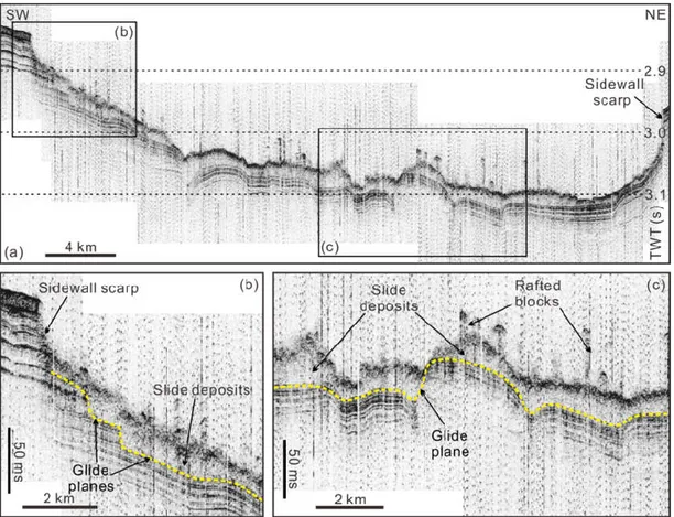
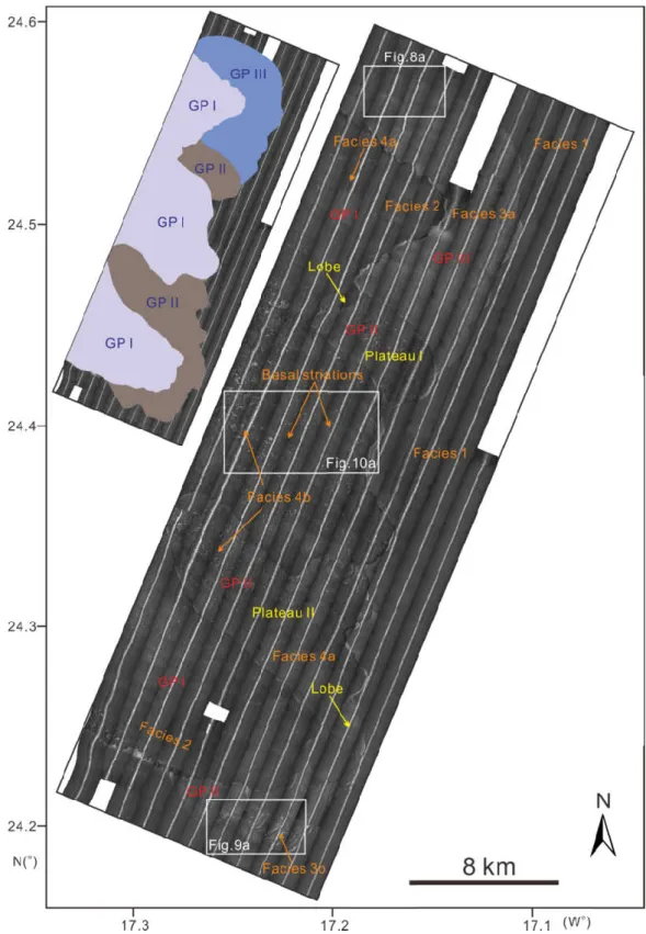
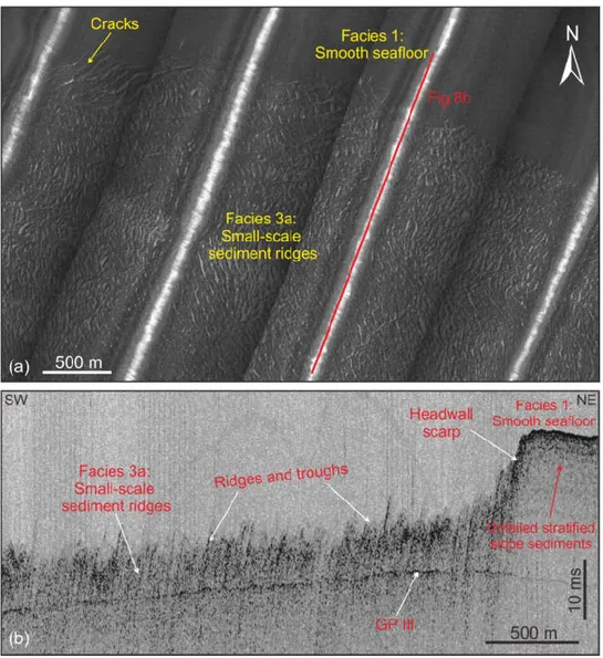
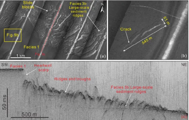
4.1 Morphology of the upper headwall ... 47
4.2 Acoustic facies ... 50
4.3 Volume estimation of the mass movements ... 56
4.4 Timing of the mass movements ... 56
5 Discussion ... 59
5.1 Types of mass movements at the headwall of the Sahara Slide Complex ... 59
5.2 Evidence for multiple slope failures ... 61
5.3 Possible preconditioning factors and triggers for slope instability at the upper headwall of the Sahara Slide Complex ... 62
5.4 Timing of the failure and implications for geohazard assessment ... 63
6 Conclusions ... 66
Reference ... 67
3 Manuscript II ... 73
Abstract ... 74
1 Introduction ... 75
2 Geological setting ... 78
2.1 Geological framework ... 78
10
2.2 Oceanographic framework ... 79
3 Data and methods ... 81
4 Seismic stratigraphy ... 83
4.1 Seismic horizons ... 83
4.2 Seismic units ... 84
5 Giant sediment mounds on the Western Sahara margin ... 87
5.1 Distribution and geometry of the sediment mounds ... 87
5.2 Internal character of the sediment mounds ... 87
6 Discussion ... 92
6.1 Genesis of the sediment mounds on the Western Sahara margin ... 92
6.2 Development processes and controlling factors of the sediment mounds ... 94
6.3 The significance of giant sediment mounds in the framework of Central Atlantic paleoceanographic evolution ... 96
7 Conclusions ... 99
References ... 100
4 Manuscript III ... 105
Abstract ... 106
1 Introduction ... 107
2 Geological setting ... 110
2.1 The Northwest African margin ... 110
2.2 The Moroccan Turbidite System ... 112
3 Data and methods ... 113
3.1 Multibeam bathymetry data ... 113
3.2 2D seismic data ... 113
3.3 Gravity cores ... 114
4 Results ... 116
4.1 Morphological description of the Agadir Slide ... 116
4.2 Internal architecture of the Agadir Slide ... 117
4.3 Volume estimation of the Agadir Slide ... 121
4.4 Age model of the Agadir Slide ... 123
5 Timing and emplacement processes of the Agadir Slide ... 125
6 Discussion ... 128
6.1 Volume discrepancy and highly erosional behavior of the Agadir Slide ... 128
6.2 Could the Agadir Slide be the source of the turbidite events in the Moroccan Turbidite System? ... 129
7 Conclusions ... 131
References ... 132
5 Final conclusions and future perspectives ... 136
5.1 Conclusions ... 136
5.2 Outlook ... 140
6 Acknowledgement ... 142
7 Curriculum Vitae ... 143
1.1 Motivation
Continental margins are the zones of the
thick continental crust; they consist of the continental shelf, slope, and rise. The modern oceans and marginal seas can be divided into shallow water and deep based on the water depth and on changes in the slope gradient
environment is the continental shelf, which extends from t
deep-water is used here to refer to the continental slope, rise, and basin environments that occur seaward of the shelf break in more than 200 m water depths. The continental slope is separated from the continental
continental rise is considered as the preferential area for final deposition of terrigenous sediment that bypassed the shelf and the slope area.
Fig.1 Shoreline crossing term ‘deep
shelf break on the slope and basin settings. The bottom part of the figure shows the t
coarse grained terrigenous sediments to pelagic sediments. Figure modified after Shanmugam (2000).
The understanding of deep
considerably after Kuenen and Migliorini’s (1950) first publi
1.1 Motivation
Continental margins are the zones of the
thick continental crust; they consist of the continental shelf, slope, and rise. The modern oceans and marginal seas can be divided into shallow water and deep based on the water depth and on changes in the slope gradient
environment is the continental shelf, which extends from t
water is used here to refer to the continental slope, rise, and basin environments that occur seaward of the shelf break in more than 200 m water depths. The continental slope is separated from the continental shelf by the shelf break, which is defined by a change in the slope gradient. The continental rise is considered as the preferential area for final deposition of terrigenous sediment that bypassed the shelf and the slope area.
Shoreline crossing
term ‘deep-water’ refers to bathyal water depths (>200 m) that occur seaward of the continental shelf break on the slope and basin settings. The bottom part of the figure shows the t
coarse grained terrigenous sediments to pelagic sediments. Figure modified after Shanmugam
The understanding of deep
considerably after Kuenen and Migliorini’s (1950) first publi
1.1 Motivation
Continental margins are the zones of the
thick continental crust; they consist of the continental shelf, slope, and rise. The modern oceans and marginal seas can be divided into shallow water and deep based on the water depth and on changes in the slope gradient
environment is the continental shelf, which extends from t
water is used here to refer to the continental slope, rise, and basin environments that occur seaward of the shelf break in more than 200 m water depths. The continental slope is separated from shelf by the shelf break, which is defined by a change in the slope gradient. The continental rise is considered as the preferential area for final deposition of terrigenous sediment that bypassed the shelf and the slope area.
Shoreline crossing bathymetric profile illustrating shallow and deep water environments. The water’ refers to bathyal water depths (>200 m) that occur seaward of the continental shelf break on the slope and basin settings. The bottom part of the figure shows the t
coarse grained terrigenous sediments to pelagic sediments. Figure modified after Shanmugam
The understanding of deep
considerably after Kuenen and Migliorini’s (1950) first publi
1 Introduction
Continental margins are the zones of the
thick continental crust; they consist of the continental shelf, slope, and rise. The modern oceans and marginal seas can be divided into shallow water and deep based on the water depth and on changes in the slope gradient
environment is the continental shelf, which extends from t
water is used here to refer to the continental slope, rise, and basin environments that occur seaward of the shelf break in more than 200 m water depths. The continental slope is separated from shelf by the shelf break, which is defined by a change in the slope gradient. The continental rise is considered as the preferential area for final deposition of terrigenous sediment that bypassed the shelf and the slope area.
bathymetric profile illustrating shallow and deep water environments. The water’ refers to bathyal water depths (>200 m) that occur seaward of the continental shelf break on the slope and basin settings. The bottom part of the figure shows the t
coarse grained terrigenous sediments to pelagic sediments. Figure modified after Shanmugam
The understanding of deep-water sedimentary systems and processes has developed considerably after Kuenen and Migliorini’s (1950) first publi
11
1 Introduction
Continental margins are the zones of the ocean floor
thick continental crust; they consist of the continental shelf, slope, and rise. The modern oceans and marginal seas can be divided into shallow water and deep based on the water depth and on changes in the slope gradient
environment is the continental shelf, which extends from t
water is used here to refer to the continental slope, rise, and basin environments that occur seaward of the shelf break in more than 200 m water depths. The continental slope is separated from shelf by the shelf break, which is defined by a change in the slope gradient. The continental rise is considered as the preferential area for final deposition of terrigenous sediment that bypassed the shelf and the slope area.
bathymetric profile illustrating shallow and deep water environments. The water’ refers to bathyal water depths (>200 m) that occur seaward of the continental shelf break on the slope and basin settings. The bottom part of the figure shows the t
coarse grained terrigenous sediments to pelagic sediments. Figure modified after Shanmugam
water sedimentary systems and processes has developed considerably after Kuenen and Migliorini’s (1950) first publi
1 Introduction
ocean floor separating the thin thick continental crust; they consist of the continental shelf, slope, and rise. The modern oceans and marginal seas can be divided into shallow water and deep based on the water depth and on changes in the slope gradient
environment is the continental shelf, which extends from the shoreline to the shelf break. The term water is used here to refer to the continental slope, rise, and basin environments that occur seaward of the shelf break in more than 200 m water depths. The continental slope is separated from shelf by the shelf break, which is defined by a change in the slope gradient. The continental rise is considered as the preferential area for final deposition of terrigenous sediment
bathymetric profile illustrating shallow and deep water environments. The water’ refers to bathyal water depths (>200 m) that occur seaward of the continental shelf break on the slope and basin settings. The bottom part of the figure shows the t
coarse grained terrigenous sediments to pelagic sediments. Figure modified after Shanmugam
water sedimentary systems and processes has developed considerably after Kuenen and Migliorini’s (1950) first publi
separating the thin thick continental crust; they consist of the continental shelf, slope, and rise. The modern oceans and marginal seas can be divided into shallow water and deep based on the water depth and on changes in the slope gradient (Fig. 1)
he shoreline to the shelf break. The term water is used here to refer to the continental slope, rise, and basin environments that occur seaward of the shelf break in more than 200 m water depths. The continental slope is separated from shelf by the shelf break, which is defined by a change in the slope gradient. The continental rise is considered as the preferential area for final deposition of terrigenous sediment
bathymetric profile illustrating shallow and deep water environments. The water’ refers to bathyal water depths (>200 m) that occur seaward of the continental shelf break on the slope and basin settings. The bottom part of the figure shows the t
coarse grained terrigenous sediments to pelagic sediments. Figure modified after Shanmugam
water sedimentary systems and processes has developed considerably after Kuenen and Migliorini’s (1950) first publication on the origin of turbidity
separating the thin oceanic crust thick continental crust; they consist of the continental shelf, slope, and rise. The morphology of modern oceans and marginal seas can be divided into shallow water and deep-water environments (Fig. 1). The shallow water he shoreline to the shelf break. The term water is used here to refer to the continental slope, rise, and basin environments that occur seaward of the shelf break in more than 200 m water depths. The continental slope is separated from shelf by the shelf break, which is defined by a change in the slope gradient. The continental rise is considered as the preferential area for final deposition of terrigenous sediment
bathymetric profile illustrating shallow and deep water environments. The water’ refers to bathyal water depths (>200 m) that occur seaward of the continental shelf break on the slope and basin settings. The bottom part of the figure shows the t
coarse grained terrigenous sediments to pelagic sediments. Figure modified after Shanmugam
water sedimentary systems and processes has developed cation on the origin of turbidity oceanic crust from morphology of water environments . The shallow water he shoreline to the shelf break. The term water is used here to refer to the continental slope, rise, and basin environments that occur seaward of the shelf break in more than 200 m water depths. The continental slope is separated from shelf by the shelf break, which is defined by a change in the slope gradient. The continental rise is considered as the preferential area for final deposition of terrigenous sediment
bathymetric profile illustrating shallow and deep water environments. The water’ refers to bathyal water depths (>200 m) that occur seaward of the continental ransition from coarse grained terrigenous sediments to pelagic sediments. Figure modified after Shanmugam
water sedimentary systems and processes has developed cation on the origin of turbidity from morphology of water environments . The shallow water he shoreline to the shelf break. The term water is used here to refer to the continental slope, rise, and basin environments that occur seaward of the shelf break in more than 200 m water depths. The continental slope is separated from shelf by the shelf break, which is defined by a change in the slope gradient. The continental rise is considered as the preferential area for final deposition of terrigenous sediment
bathymetric profile illustrating shallow and deep water environments. The water’ refers to bathyal water depths (>200 m) that occur seaward of the continental ransition from coarse grained terrigenous sediments to pelagic sediments. Figure modified after Shanmugam
water sedimentary systems and processes has developed cation on the origin of turbidity
currents and has advanced significantly in recent years (
by the interest of the hydrocarbon industry as their exploration on continental margins around the world has extended int
gas. The exploration and understanding of the deep oceans have been proposed as one of the principal scientific, technical and environmental challenges for the next century (Stow and
2000). An estimated 1200 to 1300 oil and gas fields, including discoveries and producing fields, are known from the deep
sedimentary systems and processes are complex and they formed by a variety of processes (Fig. 3;
sediment transport in deep processes, such as mass tra
along-slope sedimentary processes due to bottom currents. Contourites, turbidites and pelagites represent end
Fig.2 World map showing principal frontier areas for hydrocarbon exploration, including the main deep-water provinces (in red). Taken from
The investigation of deep marine geohazards.
palaeocurrents and palaeoclimate (Hernández drifts commonly
reflect high
main process for transporting se
currents and has advanced significantly in recent years (
by the interest of the hydrocarbon industry as their exploration on continental margins around the world has extended int
gas. The exploration and understanding of the deep oceans have been proposed as one of the principal scientific, technical and environmental challenges for the next century (Stow and
2000). An estimated 1200 to 1300 oil and gas fields, including discoveries and producing fields, are known from the deep
sedimentary systems and processes are complex and they formed by a variety of processes (Fig. 3;
sediment transport in deep processes, such as mass tra
slope sedimentary processes due to bottom currents. Contourites, turbidites and pelagites represent end-members in a continuum of deep
World map showing principal frontier areas for hydrocarbon exploration, including the main water provinces (in red). Taken from
The investigation of deep marine geohazards.
palaeocurrents and palaeoclimate (Hernández commonly present
high sedimentation rates (Rebesco et main process for transporting se
currents and has advanced significantly in recent years (
by the interest of the hydrocarbon industry as their exploration on continental margins around the world has extended into increasingly deep water in order to meet the growing demand for oil and gas. The exploration and understanding of the deep oceans have been proposed as one of the principal scientific, technical and environmental challenges for the next century (Stow and
2000). An estimated 1200 to 1300 oil and gas fields, including discoveries and producing fields, are known from the deep-water sedimentary systems in the past decades
sedimentary systems and processes are complex and they formed by a variety of processes (Fig. 3;
sediment transport in deep-water environments includes gravity
processes, such as mass transport (i.e., slides, slumps, and debris flows) and turbidity currents, and slope sedimentary processes due to bottom currents. Contourites, turbidites and pelagites
members in a continuum of deep
World map showing principal frontier areas for hydrocarbon exploration, including the main water provinces (in red). Taken from
The investigation of deep
marine geohazards. Contourites can be considered as ideal records palaeocurrents and palaeoclimate (Hernández
present significant lateral continuity sedimentation rates (Rebesco et
main process for transporting se
currents and has advanced significantly in recent years (
by the interest of the hydrocarbon industry as their exploration on continental margins around the o increasingly deep water in order to meet the growing demand for oil and gas. The exploration and understanding of the deep oceans have been proposed as one of the principal scientific, technical and environmental challenges for the next century (Stow and
2000). An estimated 1200 to 1300 oil and gas fields, including discoveries and producing fields, are water sedimentary systems in the past decades
sedimentary systems and processes are complex and they formed by a variety of processes (Fig. 3;
water environments includes gravity
nsport (i.e., slides, slumps, and debris flows) and turbidity currents, and slope sedimentary processes due to bottom currents. Contourites, turbidites and pelagites
members in a continuum of deep
World map showing principal frontier areas for hydrocarbon exploration, including the main water provinces (in red). Taken from
The investigation of deep-water systems is also important for investigating paleoclimate and ontourites can be considered as ideal records
palaeocurrents and palaeoclimate (Hernández
significant lateral continuity sedimentation rates (Rebesco et
main process for transporting sediments from onshore sources to offshore sinks. Galy et al.
12
currents and has advanced significantly in recent years (
by the interest of the hydrocarbon industry as their exploration on continental margins around the o increasingly deep water in order to meet the growing demand for oil and gas. The exploration and understanding of the deep oceans have been proposed as one of the principal scientific, technical and environmental challenges for the next century (Stow and
2000). An estimated 1200 to 1300 oil and gas fields, including discoveries and producing fields, are water sedimentary systems in the past decades
sedimentary systems and processes are complex and they
formed by a variety of processes (Fig. 3; Stow and Mayall, 2000; Stevenson et al., 2015 water environments includes gravity
nsport (i.e., slides, slumps, and debris flows) and turbidity currents, and slope sedimentary processes due to bottom currents. Contourites, turbidites and pelagites
members in a continuum of deep-water sedimentary facies (Rebesco et al
World map showing principal frontier areas for hydrocarbon exploration, including the main water provinces (in red). Taken from http://www.bbc.co.uk/news/10298342
water systems is also important for investigating paleoclimate and ontourites can be considered as ideal records
palaeocurrents and palaeoclimate (Hernández-Molina significant lateral continuity sedimentation rates (Rebesco et al., 2014).
diments from onshore sources to offshore sinks. Galy et al.
currents and has advanced significantly in recent years (e.g., Mulder, 2011). This is largely driven by the interest of the hydrocarbon industry as their exploration on continental margins around the o increasingly deep water in order to meet the growing demand for oil and gas. The exploration and understanding of the deep oceans have been proposed as one of the principal scientific, technical and environmental challenges for the next century (Stow and
2000). An estimated 1200 to 1300 oil and gas fields, including discoveries and producing fields, are water sedimentary systems in the past decades
sedimentary systems and processes are complex and they are populated by multiple products Stow and Mayall, 2000; Stevenson et al., 2015
water environments includes gravity
nsport (i.e., slides, slumps, and debris flows) and turbidity currents, and slope sedimentary processes due to bottom currents. Contourites, turbidites and pelagites
water sedimentary facies (Rebesco et al
World map showing principal frontier areas for hydrocarbon exploration, including the main http://www.bbc.co.uk/news/10298342
water systems is also important for investigating paleoclimate and ontourites can be considered as ideal records
Molina et al., 200 significant lateral continuity, contain limited
al., 2014). Gravity
diments from onshore sources to offshore sinks. Galy et al.
Mulder, 2011). This is largely driven by the interest of the hydrocarbon industry as their exploration on continental margins around the o increasingly deep water in order to meet the growing demand for oil and gas. The exploration and understanding of the deep oceans have been proposed as one of the principal scientific, technical and environmental challenges for the next century (Stow and
2000). An estimated 1200 to 1300 oil and gas fields, including discoveries and producing fields, are water sedimentary systems in the past decades (Fig. 2)
are populated by multiple products Stow and Mayall, 2000; Stevenson et al., 2015
water environments includes gravity-driven downslope sedimentary nsport (i.e., slides, slumps, and debris flows) and turbidity currents, and slope sedimentary processes due to bottom currents. Contourites, turbidites and pelagites
water sedimentary facies (Rebesco et al
World map showing principal frontier areas for hydrocarbon exploration, including the main http://www.bbc.co.uk/news/10298342
water systems is also important for investigating paleoclimate and ontourites can be considered as ideal records of
et al., 2006), as the deposits comprising the contain limited depositional
Gravity-driven sediment transport is the diments from onshore sources to offshore sinks. Galy et al.
Mulder, 2011). This is largely driven by the interest of the hydrocarbon industry as their exploration on continental margins around the o increasingly deep water in order to meet the growing demand for oil and gas. The exploration and understanding of the deep oceans have been proposed as one of the principal scientific, technical and environmental challenges for the next century (Stow and
2000). An estimated 1200 to 1300 oil and gas fields, including discoveries and producing fields, are (Fig. 2). The deep are populated by multiple products Stow and Mayall, 2000; Stevenson et al., 2015
driven downslope sedimentary nsport (i.e., slides, slumps, and debris flows) and turbidity currents, and slope sedimentary processes due to bottom currents. Contourites, turbidites and pelagites
water sedimentary facies (Rebesco et al
World map showing principal frontier areas for hydrocarbon exploration, including the main http://www.bbc.co.uk/news/10298342
water systems is also important for investigating paleoclimate and of long-term variations in he deposits comprising the
depositional
driven sediment transport is the diments from onshore sources to offshore sinks. Galy et al.
Mulder, 2011). This is largely driven by the interest of the hydrocarbon industry as their exploration on continental margins around the o increasingly deep water in order to meet the growing demand for oil and gas. The exploration and understanding of the deep oceans have been proposed as one of the principal scientific, technical and environmental challenges for the next century (Stow and Mayall, 2000). An estimated 1200 to 1300 oil and gas fields, including discoveries and producing fields, are . The deep-water are populated by multiple products Stow and Mayall, 2000; Stevenson et al., 2015). In general,
driven downslope sedimentary nsport (i.e., slides, slumps, and debris flows) and turbidity currents, and slope sedimentary processes due to bottom currents. Contourites, turbidites and pelagites
water sedimentary facies (Rebesco et al., 2014).
World map showing principal frontier areas for hydrocarbon exploration, including the main
water systems is also important for investigating paleoclimate and term variations in he deposits comprising the hiatuses, and driven sediment transport is the diments from onshore sources to offshore sinks. Galy et al. (2007
Mulder, 2011). This is largely driven by the interest of the hydrocarbon industry as their exploration on continental margins around the o increasingly deep water in order to meet the growing demand for oil and gas. The exploration and understanding of the deep oceans have been proposed as one of the Mayall, 2000). An estimated 1200 to 1300 oil and gas fields, including discoveries and producing fields, are water are populated by multiple products . In general, driven downslope sedimentary nsport (i.e., slides, slumps, and debris flows) and turbidity currents, and slope sedimentary processes due to bottom currents. Contourites, turbidites and pelagites
World map showing principal frontier areas for hydrocarbon exploration, including the main
water systems is also important for investigating paleoclimate and term variations in he deposits comprising the hiatuses, and driven sediment transport is the 2007)
proposed that
sequester globally significant volumes of organic carbon form many of the World’s largest oil and gas reservoirs submarine landslides and turbidity currents
seafloor infrastructure
tsunamis (Harbitz et al, 2014).
The knowledge on deep
the recent improvements in technologies, such as the advent of high a broad range of deep
and reservoir
deep-tow sidescan sonar and other imagin
Fig.3 Schematic diagram showing complex deep water depths than 200 m (shelf
During the past decades
continental margin and various types of deep
transport deposits (MTDs), turbidites and contourites, have been discovered across the margin (Wynn et a
considered as an ideal laboratory in order to investigate deep processes.
proposed that mud
sequester globally significant volumes of organic carbon rm many of the World’s largest oil and gas reservoirs submarine landslides and turbidity currents
seafloor infrastructure
tsunamis (Harbitz et al, 2014).
The knowledge on deep
the recent improvements in technologies, such as the advent of high a broad range of deep
and reservoir-level deep
tow sidescan sonar and other imagin
Schematic diagram showing complex deep water depths than 200 m (shelf
uring the past decades
continental margin and various types of deep
transport deposits (MTDs), turbidites and contourites, have been discovered across the margin (Wynn et al., 2000;
considered as an ideal laboratory in order to investigate deep processes.
mud-rich deposits of gravity flows sequester globally significant volumes of organic carbon
rm many of the World’s largest oil and gas reservoirs submarine landslides and turbidity currents
seafloor infrastructures (Krastel et al., 2014 tsunamis (Harbitz et al, 2014).
The knowledge on deep-
the recent improvements in technologies, such as the advent of high
a broad range of deep-water environments, (2) the recent drilling and coring of both near
level deep-water systems, and (3) the increasing utilization of multibeam bathymetry, tow sidescan sonar and other imagin
Schematic diagram showing complex deep water depths than 200 m (shelf
uring the past decades
continental margin and various types of deep
transport deposits (MTDs), turbidites and contourites, have been discovered across the margin l., 2000; Krastel et al., 2012
considered as an ideal laboratory in order to investigate deep rich deposits of gravity flows
sequester globally significant volumes of organic carbon rm many of the World’s largest oil and gas reservoirs submarine landslides and turbidity currents
Krastel et al., 2014 tsunamis (Harbitz et al, 2014).
water sedimentary systems and processes have benefited greatly from the recent improvements in technologies, such as the advent of high
water environments, (2) the recent drilling and coring of both near
water systems, and (3) the increasing utilization of multibeam bathymetry, tow sidescan sonar and other imagin
Schematic diagram showing complex deep water depths than 200 m (shelf-slope break)
uring the past decades intensive studies have been focused on the Northwest African continental margin and various types of deep
transport deposits (MTDs), turbidites and contourites, have been discovered across the margin Krastel et al., 2012). Thus, the northwest Africa continental margin could be considered as an ideal laboratory in order to investigate deep
13
rich deposits of gravity flows sequester globally significant volumes of organic carbon
rm many of the World’s largest oil and gas reservoirs submarine landslides and turbidity currents are also
Krastel et al., 2014). In addition, slope failures may trigger devastating
water sedimentary systems and processes have benefited greatly from the recent improvements in technologies, such as the advent of high
water environments, (2) the recent drilling and coring of both near
water systems, and (3) the increasing utilization of multibeam bathymetry, tow sidescan sonar and other imaging devices.
Schematic diagram showing complex deep-water sedimentary environments occurring at slope break)(Shanmugam, 2000
ntensive studies have been focused on the Northwest African continental margin and various types of deep-water sedimentary systems, e.g., canyons, mass transport deposits (MTDs), turbidites and contourites, have been discovered across the margin ). Thus, the northwest Africa continental margin could be considered as an ideal laboratory in order to investigate deep
in the deep sequester globally significant volumes of organic carbon and
rm many of the World’s largest oil and gas reservoirs. Gravity are also suggested as
In addition, slope failures may trigger devastating
water sedimentary systems and processes have benefited greatly from the recent improvements in technologies, such as the advent of high
water environments, (2) the recent drilling and coring of both near
water systems, and (3) the increasing utilization of multibeam bathymetry,
water sedimentary environments occurring at Shanmugam, 2000)
ntensive studies have been focused on the Northwest African water sedimentary systems, e.g., canyons, mass transport deposits (MTDs), turbidites and contourites, have been discovered across the margin ). Thus, the northwest Africa continental margin could be considered as an ideal laboratory in order to investigate deep
in the deep-water sedimentary systems and sand-rich gravityflow deposits . Gravity-driven downslope processes, e.g.
suggested as significant
In addition, slope failures may trigger devastating
water sedimentary systems and processes have benefited greatly from the recent improvements in technologies, such as the advent of high-quality 3D se
water environments, (2) the recent drilling and coring of both near
water systems, and (3) the increasing utilization of multibeam bathymetry,
water sedimentary environments occurring at ).
ntensive studies have been focused on the Northwest African water sedimentary systems, e.g., canyons, mass transport deposits (MTDs), turbidites and contourites, have been discovered across the margin ). Thus, the northwest Africa continental margin could be considered as an ideal laboratory in order to investigate deep-water sedimentary
water sedimentary systems rich gravityflow deposits driven downslope processes, e.g.
significant marine
In addition, slope failures may trigger devastating
water sedimentary systems and processes have benefited greatly from quality 3D seismic data across water environments, (2) the recent drilling and coring of both near
water systems, and (3) the increasing utilization of multibeam bathymetry,
water sedimentary environments occurring at
ntensive studies have been focused on the Northwest African water sedimentary systems, e.g., canyons, mass transport deposits (MTDs), turbidites and contourites, have been discovered across the margin ). Thus, the northwest Africa continental margin could be
water sedimentary
water sedimentary systems may rich gravityflow deposits may driven downslope processes, e.g.
marine geohazards In addition, slope failures may trigger devastating
water sedimentary systems and processes have benefited greatly from ismic data across water environments, (2) the recent drilling and coring of both near-surface water systems, and (3) the increasing utilization of multibeam bathymetry,
water sedimentary environments occurring at
ntensive studies have been focused on the Northwest African water sedimentary systems, e.g., canyons, mass transport deposits (MTDs), turbidites and contourites, have been discovered across the margin ). Thus, the northwest Africa continental margin could be water sedimentary systems and may may driven downslope processes, e.g.
s to In addition, slope failures may trigger devastating
water sedimentary systems and processes have benefited greatly from ismic data across surface water systems, and (3) the increasing utilization of multibeam bathymetry,
ntensive studies have been focused on the Northwest African water sedimentary systems, e.g., canyons, mass transport deposits (MTDs), turbidites and contourites, have been discovered across the margin ). Thus, the northwest Africa continental margin could be systems and
1.2 Deep
1.2.1 Gravity Gravity slumps, cohesive
principal agents and mech
downslope from the continent slope into the deep
Fig.4 Schematic diagram showing four common types of gravity transport sediment into deep
1.2.1.1 Submarine landslides and mass Submarine landslides are composed m deposits are termed as mass
a coherent mass of sediment that moves along a planar plane and shows almost no internal deformation. A
undergoes rotational movements causing internal deformation. A debris flow is a sediment flow with plastic rheology and laminar state from which deposition occurs through freez
(Shanmugam, 2016
Submarine landslides are an important mechanism in shaping continental slopes, and have been widely documented on both active and passive margins (
al., 2014). The failed sediment moves
1.2 Deep-water sedimentary system and processes
Gravity-driven downslope sedimentary processes
Gravity-driven downslope sedimentary processes comprise a range of processes from slides, slumps, cohesive debris flows
principal agents and mech
downslope from the continent slope into the deep
Schematic diagram showing four common types of gravity transport sediment into deep
1.2.1.1 Submarine landslides and mass Submarine landslides are composed m deposits are termed as mass
a coherent mass of sediment that moves along a planar plane and shows almost no internal deformation. A slump is a coherent mass of sediment that moves on a concave
undergoes rotational movements causing internal deformation. A debris flow is a sediment flow with plastic rheology and laminar state from which deposition occurs through freez
Shanmugam, 2016
Submarine landslides are an important mechanism in shaping continental slopes, and have been widely documented on both active and passive margins (
al., 2014). The failed sediment moves
water sedimentary system and processes
iven downslope sedimentary processes
driven downslope sedimentary processes comprise a range of processes from slides, debris flows
principal agents and mechanisms for transporting and bypassing large volumes of sediment downslope from the continent slope into the deep
Schematic diagram showing four common types of gravity transport sediment into deep-marine environments (Shanmugam, 2016).
1.2.1.1 Submarine landslides and mass Submarine landslides are composed m
deposits are termed as mass-transport deposits (MTDs) (
a coherent mass of sediment that moves along a planar plane and shows almost no internal slump is a coherent mass of sediment that moves on a concave
undergoes rotational movements causing internal deformation. A debris flow is a sediment flow with plastic rheology and laminar state from which deposition occurs through freez
Shanmugam, 2016).
Submarine landslides are an important mechanism in shaping continental slopes, and have been widely documented on both active and passive margins (
al., 2014). The failed sediment moves
water sedimentary system and processes
iven downslope sedimentary processes
driven downslope sedimentary processes comprise a range of processes from slides, debris flows to dilute turbidity currents (
anisms for transporting and bypassing large volumes of sediment downslope from the continent slope into the deep
Schematic diagram showing four common types of gravity marine environments (Shanmugam, 2016).
1.2.1.1 Submarine landslides and mass- Submarine landslides are composed m
transport deposits (MTDs) (
a coherent mass of sediment that moves along a planar plane and shows almost no internal slump is a coherent mass of sediment that moves on a concave
undergoes rotational movements causing internal deformation. A debris flow is a sediment flow with plastic rheology and laminar state from which deposition occurs through freez
Submarine landslides are an important mechanism in shaping continental slopes, and have been widely documented on both active and passive margins (
al., 2014). The failed sediment moves downslope when the shear stress exceeds the shear strength
14
water sedimentary system and processes
iven downslope sedimentary processes
driven downslope sedimentary processes comprise a range of processes from slides, to dilute turbidity currents (
anisms for transporting and bypassing large volumes of sediment downslope from the continent slope into the deep-marine environments (Masson et al., 2006).
Schematic diagram showing four common types of gravity marine environments (Shanmugam, 2016).
-transport deposits (MTDs)
Submarine landslides are composed mainly of slides, slumps and debris flows and their transport deposits (MTDs) (
a coherent mass of sediment that moves along a planar plane and shows almost no internal slump is a coherent mass of sediment that moves on a concave
undergoes rotational movements causing internal deformation. A debris flow is a sediment flow with plastic rheology and laminar state from which deposition occurs through freez
Submarine landslides are an important mechanism in shaping continental slopes, and have been widely documented on both active and passive margins (
downslope when the shear stress exceeds the shear strength
water sedimentary system and processes
iven downslope sedimentary processes
driven downslope sedimentary processes comprise a range of processes from slides, to dilute turbidity currents (Fig. 4;
anisms for transporting and bypassing large volumes of sediment marine environments (Masson et al., 2006).
Schematic diagram showing four common types of gravity marine environments (Shanmugam, 2016).
transport deposits (MTDs)
ainly of slides, slumps and debris flows and their transport deposits (MTDs) (Fig. 4;
a coherent mass of sediment that moves along a planar plane and shows almost no internal slump is a coherent mass of sediment that moves on a concave
undergoes rotational movements causing internal deformation. A debris flow is a sediment flow with plastic rheology and laminar state from which deposition occurs through freez
Submarine landslides are an important mechanism in shaping continental slopes, and have been widely documented on both active and passive margins (Fig. 5;
downslope when the shear stress exceeds the shear strength
water sedimentary system and processes
driven downslope sedimentary processes comprise a range of processes from slides, Fig. 4; Talling et al., 2012). They are the anisms for transporting and bypassing large volumes of sediment
marine environments (Masson et al., 2006).
Schematic diagram showing four common types of gravity-driven downslope processes that marine environments (Shanmugam, 2016).
transport deposits (MTDs)
ainly of slides, slumps and debris flows and their Fig. 4; Moscardelli et al., 2006
a coherent mass of sediment that moves along a planar plane and shows almost no internal slump is a coherent mass of sediment that moves on a concave
undergoes rotational movements causing internal deformation. A debris flow is a sediment flow with plastic rheology and laminar state from which deposition occurs through freez
Submarine landslides are an important mechanism in shaping continental slopes, and have Fig. 5; Masson et al., 2006; Krastel et downslope when the shear stress exceeds the shear strength driven downslope sedimentary processes comprise a range of processes from slides, Talling et al., 2012). They are the anisms for transporting and bypassing large volumes of sediment
marine environments (Masson et al., 2006).
driven downslope processes that
ainly of slides, slumps and debris flows and their Moscardelli et al., 2006
a coherent mass of sediment that moves along a planar plane and shows almost no internal slump is a coherent mass of sediment that moves on a concave-up glide plane and undergoes rotational movements causing internal deformation. A debris flow is a sediment flow with plastic rheology and laminar state from which deposition occurs through freez
Submarine landslides are an important mechanism in shaping continental slopes, and have Masson et al., 2006; Krastel et downslope when the shear stress exceeds the shear strength driven downslope sedimentary processes comprise a range of processes from slides, Talling et al., 2012). They are the anisms for transporting and bypassing large volumes of sediment
marine environments (Masson et al., 2006).
driven downslope processes that
ainly of slides, slumps and debris flows and their Moscardelli et al., 2006). A slide is a coherent mass of sediment that moves along a planar plane and shows almost no internal up glide plane and undergoes rotational movements causing internal deformation. A debris flow is a sediment flow with plastic rheology and laminar state from which deposition occurs through freezing en masse
Submarine landslides are an important mechanism in shaping continental slopes, and have Masson et al., 2006; Krastel et downslope when the shear stress exceeds the shear strength driven downslope sedimentary processes comprise a range of processes from slides, Talling et al., 2012). They are the anisms for transporting and bypassing large volumes of sediment
driven downslope processes that
ainly of slides, slumps and debris flows and their ). A slide is a coherent mass of sediment that moves along a planar plane and shows almost no internal up glide plane and undergoes rotational movements causing internal deformation. A debris flow is a sediment flow ing en masse
Submarine landslides are an important mechanism in shaping continental slopes, and have Masson et al., 2006; Krastel et downslope when the shear stress exceeds the shear strength