Katharina Deichsel
“Our Lake Is Our Farm”:
Local Knowledge of Tugen Fishermen on Environmental Changes of
Lake Baringo, Kenya
Edited by the Cologne African Studies Centre
Cologne 2019
16
Katharina Deichsel
“Our Lake Is Our Farm”
Local Knowledge of Tugen Fishermen on Environmental Changes of Lake Baringo, Kenya
CULTURE AND ENVIRONMENT IN AFRICA SERIES
Edited by the Cologne African Studies Centre
Issue 16 2019
Preface
The ethnography of East Africa has astonishingly little to say about people making their living along the sweet-water lakes of the Rift Valley. While the major lakes, i.e. Lake Victoria, Lake Tanganyika or Lake Malawi perhaps gained some consideration, the smaller sweet- water lakes are almost absent from social-science literature. In the historiography of Kenya and Tanzania these lakes have been depicted as ecological niches and last resort for impoverished and famished populations which lost their herds due to drought or epidemic diseases, who suffered from failed harvests or who had been victims of violence. The options for fishery, a craft that needs little technological input nor does it need any land rights, were good along the shores of these erstwhile fish abundant lakes. Deichsel deals with one such lake, Lake Baringo in the northern Kenyan Rift Valley. Also, Lake Baringo has served as a last resort for herders. Especially along its northern shores pastoral Pokot settled in case their herds had been depleted beyond a minimal subsistence level. The Njemps community has had a more continuous hold of the lake’s resources and the Tugen, on which Deichsel’s thesis focuses, came to the lake shores during British colonial times.
The colonial administration broke the military superiority of pastoralist communities in the region and provided the Tugen community with guaranteed access to the lake. Since about 60 to 80 years Tugen fishermen have worked on and with the lake accumulating an invaluable set of indigenous knowledge. It is this knowledge that Deichsel’s thesis focuses upon. Deichsel conducted fieldwork at Lake Baringo for about 2 months in 2013. She interviewed mainly males from the small Tugen fishermen community. While the larger part of her interviews were qualitative focusing on the history of human-environment relations at the lake, she also employed formalized questionnaires to elicit cognitive patterns. Deichsel is especially interested in how Tugen fishermen interpret certain hazards that endanger their livelihoods.
Abstract
Wetlands constitute some of the most important ecosystems in the world. They provide a number of critical ecosystem services that are indispensable to human beings and to the survival of biodiversities, health and welfare. Despite their importance, wetlands are being degraded and lost more rapidly than other ecosystems. In Kenya, where wetlands cover 3- 4% of the country surface area, their rich physical and biological resources have led them to be overexploited and many of these ecosystems are seriously degraded. Wetland management decisions in Kenya are usually implemented by government departments and institutions with very little local community involvement. Based on the understanding that the integration of local knowledge is necessary to formulate adequate management strategies and that local involvement helps to enforce those, this study seeks to capture the value of local knowledge for wetland management approaches as well as for further research work. Specifically, this study focuses on local knowledge of Tugen fishermen on the environmental changes of the Ramsar Site of Lake Baringo in in mid-west Kenya.
Contents
Preface ... iii
Abstract ... iv
List of acronyms ... vi
List of figures ... vii
List of images ... vii
List of maps ... vii
List of tables ... vii
1 Introduction ... 1
1.1 Research objective and questions ... 2
1.2 Composition of the thesis ... 2
2 Data collection and analysis ... 4
2.1 Methodology: choice of study area and informants ... 4
2.2 Data collection ... 5
2.2.1 Unstructured interviews ... 5
2.2.2 Card piling ... 6
2.3 Data analysis: qualitative content analysis after Philip Mayring ... 6
3 Literature review and concepts... 9
3.1 Local knowledge ... 9
3.2 Hazards and hazard perception ... 11
3.3 Environmental change ... 13
4 Context of Lake Baringo ... 15
4.1 Climatic situation and environment ... 15
4.2 Lake Baringo as a Ramsar Site... 15
4.3 Means of income in the Baringo area ... 16
4.3.1 Fishing ... 17
4.3.2 Agriculture ... 18
4.3.3 Tourism ... 18
5 Data presentation ... 20
5.1 Tugen fishing practice today and in the past ... 22
5.2 Fluctuating water levels ... 24
5.3 Fish stock ... 29
5.4 Introduced plant species: Prosopis juliflora ... 32
5.5 Hazards to the lake ... 34
6 Discussion ... 38
7 Conclusion ... 44
8 List of references ... 46
List of acronyms
ASALs Arid and Semi-Arid Lands
DEWA Division of Early Warning and Assessment
FAO Food and Agriculture Organization of the United Nations
IFRC International Federation of Red Cross and Red Crescent Societies IISD International Institute for Sustainable Development
ILEC International Lake Environment Committee MEA UN Millennium Environment Assessment
MEMR Ministry of Environment and Mineral Resources (Kenya) MoDP Ministry of Devolution and Planning (Kenya)
NCPD National Council for Population and Development (Kenya) NDMA National Drought Management Authority (Kenya)
NEMA National Environmental Management Authority (Kenya) UNEP United Nation Environment Programme
List of figures
Figure 1a. Ranks of major hazards to Lake Baringo (n=10) ... 20
Figure 1b. Visually weighted list of major hazards to Lake Baringo (n=10)... 20
Figure 2a. Gradual ranks of the category “most hazardous” (n=10) ... 21
Figure 2b. Visually weighted list of category "most hazardous" (n=10) ... 21
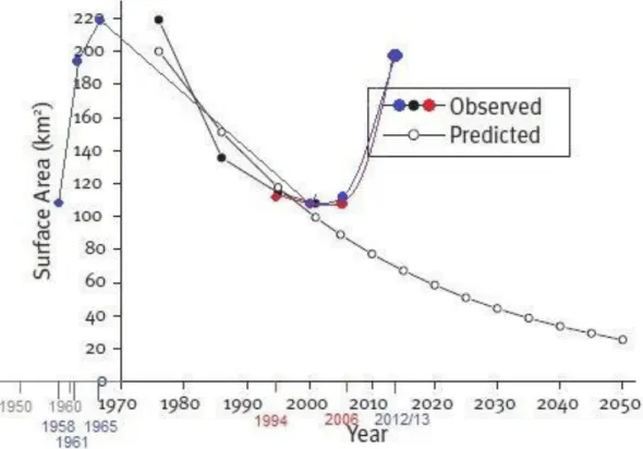
Figure 3. Observed and predicted surface area of Lake Baringo ... 26
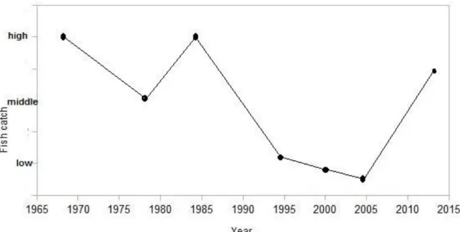
Figure 4. Trend of fish production in Lake Baringo based on fishermen's experiences ... 30
List of images Image 1: Tugen fishing boat made from balsa wood ... 23
Images 2a. Water level of Lake Baringo during study period. Study site: Ngenyin Beach ... 28
Images 2b. Water level of Lake Baringo during study period. Kampi ya Samaki ... 29
Images 3a/b. Satellite image of Prosopis distribution in Baringo District 1973 & 2008 ... 33
List of maps Map 1: Lake Baringo with study site ... 5
List of tables Table 1: Terms used for card piling process ... 6
Table 2: Complete categories and sub categories resulting from content analysis... 8
1 Introduction
Wetlands constitute some of the most important ecosystems in the world. They provide a number of critical “ecosystem services” (MEA 2005) that are indispensable to human beings and to the survival of biodiversities, health and welfare. These ecosystem services provided by or derived from wetlands are a) provisioning services such as food, fresh water, fibre and fuel, b) supporting services such as soil formation and nutrient cycling (which is “the storage, recycling, processing, acquisition of nutrients” (MEMR 2012, 70)), c) regulating services such as water regulation, erosion regulation and natural hazard regulation and d) cultural services like recreational and aesthetic values (MEMR 2012). Despite their importance for humankind and nature, wetlands including water catchment areas are being degraded and lost more rapidly than other ecosystems (ibid).
In Kenya, wetlands cover 3-4% of the country surface area. Their rich physical and biological resources have led them to be overexploited and many of these ecosystems are seriously degraded (MEMR 2012). Even though the Ramsar Convention's wise use of wetlands principle has been in force in Kenya since 1990, the absence of a national wetlands policy and a sector-specific wetlands law continue to hinder sustainable wetland management (ibid). The wise use of wetlands principle is defined as “maintenance of their ecological character, achieved through the implementation of ecosystem approach, within the context of sustainable development” (Ramsar Convention Secretariat 2006, 50). In Kenya, where the principle yet needs to be fully realised, major challenges facing wetlands include: over-extraction of water, fragmentation of land, deforestation of major water catchment areas, overgrazing, invasive species, over-exploitation of wetlands goods, such as fish and plants, and others (UNEP News Centre 2013).
With the need of improvement for wetland management at government level, the questions arise what role local stakeholder play regarding control over their immediate environment and how their experiences could impel management efforts. As described above, in Kenya major management decisions are usually implemented by government departments and institutions with very little local community involvement (Terer et al. 2004). However, lessons learnt during assessments in lake1 areas have shown that “involvement of communities helps make the benefits of the rules clearer to those affected, draws upon the accepted authority of local leadership, uses their local knowledge for better design and enforcement, and reduces the cost to the central government”, as the International Lake Environment Committee noted (ILEC 2005, 43).
1 Lakes are a type of wetland according to the Ramsar Convention which describes wetlands as
“areas of marsh, fen, peatland or water, whether natural or artificial, permanent or temporary, with water that is static or flowing, fresh, brackish or salt, including areas of marine water the depth of which at low tide does not exceed six metres” (Ramsar Convention Secretariat 2006).
This definition does not encompass permanent, deep water bodies although it includes the
This study was designed based on the understanding described above, namely that the integration of local knowledge is necessary to formulate adequate rules and that local involvement helps to enforce those. Specifically the possibilities of local knowledge for the analysis of environmental changes in the fragile ecosystem of a wetland, were explored.
Thereby Lake Baringo was chosen as study site: the Rift Valley lake is a Wetlands of International Importance (Ramsar Sites) which is, as a freshwater body, particularly important for local residents. The lake has repeatedly undergone environmental changes within the last century, which have greatly impacted lake communities (Aloo 2004; ILEC 2005; Johansson et al. 2002; Odada et al. 2006; Lwenya et al. 2010 and others). For this reason, this study aimed to analyse knowledge of fishermen from the local Tugen community on environmental changes of Lake Baringo. It was intended to tap this mostly underestimated source of knowledge using unstructured interviews and card piling processes to give a local perspective on which environmental challenges there are for the lake, its environment and for those relying on the lake as a resource for their livelihood.
1.1 Research objective and questions
Based on the situation described above, this case study was conducted with the following objectives and research questions in mind:
1) To explore local knowledge of Tugen fishermen on the ecosystem of Lake Baringo a) What changes have Tugen fisher been observing over time regarding the lake, fish
stock, and the adjacent environment?
b) How do they interpret those changes?
2) To analyse the fishermen's understanding of hazards to the lake environment;
a) What are the hazards to the lake's ecosystem and b) How do fishermen evaluate them?
3) The fishermen’s knowledge on the lake’s ecosystem shall then be developed into a form of hybrid-knowledge using scientific data from other sources.
a) What official data is there regarding the changing environment of Lake Baringo?
b) In what way can Tugen local knowledge be incorporated in scientific research and therefore function as a complementing source of knowledge?
1.2 Composition of the thesis
The composition of this thesis consists of the following:
• Introducing the research question in chapter one;
• A portrayal of data collection and methods of analysis in chapter two;
• An explanation of key terms and concepts such as local knowledge, hazard and hazard perception and environmental change will be presented in chapter three;
• In chapter four the context of Lake Baringo, namely the lake as a Ramsar Site, the lake area's climatic characteristics as well as the socio-economic situation for local communities will be focused on;
• Presenting and scrutinising data gathered during fieldwork occurs in chapter five;
• The discussion which reflects on the main findings of the research follows in chapter six; and
• Conclusion will be the frame of chapters seven.
2 Data collection and analysis
2.1 Methodology: choice of study area and informants
This study was carried out from March 15th to April 21st, 2013 at Ngenyin Beach of Lake Baringo in mid-west Kenya. Lake Baringo is one of the seven inland drainage lakes within the Kenyan section of the Rift Valley and it drains an area of over 6800 km2. The lake lies at an altitude of 915m above sea level, latitude 0º44 ́and 0º 34 N and longitudes 36º 00 ́E and 36º 10 ́E. (Ngaira 2005)
The two main perennial rivers are Perkerra and Molo which, however, have significantly reduced water discharge during dry seasons. Further, several seasonal rivers drain the lake, including Ol Arabel, Makutan, Tangulbei, Endao and Chemeron. Lake Baringo is one of two Kenyan freshwater Rift Valley lakes (the other is Lake Nakuru); as a freshwater body in a semi-arid region, the lake is most-valuable as water resource for domestic and livestock consumption and it provides additional possibilities of income through fishing and tourism.
In 2002 Lake Baringo gained recognition as a wetland of international importance, this in turn has led to more options being available to support livelihood opportunities there (Odada et al. 2006; Ramsar Convention Secretariat 2002).
Indigenous communities living in the basin area are the Pokot, the Njemps and the Tugen.
The Pokot do their fishing in the northern part of the lake. In the eastern and southern part and on the islands are the Njemps. Tugen live and fish on the west shores, as Douglas Limo, employee of the Department of Fishery in Kampi ya Samaki explained (Interview with Douglas Limo on 14 April 2013).
Ngenyin Beach, the place of study, is a designated fish landing site; it is located on the west shore, approximately a 60 minutes hike or a 15 minutes bodaboda-ride (motorcycle-taxi) north of Kampi ya Samaki, the only major town by the lake (map 1). The beach is therefore quite remote and especially during wet season not easy to access because the paths to the beach turn muddy and become hardly passable. The environment of the landing site is hallmarked by volcanic ground and bushwood some of which is of the Prosopis juliflora species. All fishermen operating from Ngenyin Beach are members of the Tugen community. By their own account there were 30 fishermen and a community of 1000 people associated with the fishermen of Ngenyin Beach. Fish is a source of food and the sale of fish in Kampi ya Samaki generates income for the community. Within the Tugen community jobs are clearly allocated: men fish, women gut and clean the fish before selling them on the market in Kampi ya Samaki (for more detail see 5.1).
Map 1: Lake Baringo with study site Source: Aloo 2004
2.2 Data collection
2.2.1 Unstructured interviews
When beginning this fieldwork, the intention was to slowly enter the field in order to get to know all informants and their living environment. This way the research could be guided by local knowledge: by pointing out topics related to environmental change of Lake Baringo, informants helped to focus and to structure this study. That is why unstructured interviews were chosen as the most suitable method for the first phase of this study.
Unstructured interviews are based on a clear plan that you keep constantly in mind, but are also characterized by a minimum of control over the people’s responses. The idea is to get people to open up and let them express themselves in their own terms, and at their own pace. […] Unstructured interviewing is used in situations where you have lots and lots of time […] (Bernard 2011, 157).
As Bernard points out, “lots and lots of time” is crucial when conducting unstructured interviews. Due to the time restraints of this study there was a need for follow-up questions in the process of interviewing. However, interviews did not follow a prepared list; questions asked mainly helped to clarify information previously given by the informant. All interviews were translated on the spot by a local translator, Elijah Limo (42), who himself is a member of that Tugen community and whose father is an active fisherman. Thus, interviews were carried out in Tugen, a Kalenjin dialect, immediately translated into English (and vice versa) and recorded for later transcription. The transcription of speech was carried out at a later point in time, however still in Kenya. During the interviews the information gained was
thoroughly analysed back in Germany following the qualitative content analysis, a method created by Philip Mayring (see 2.3).
2.2.2 Card piling
The method of card piling is used when exploring cognitive relations between certain topics (Bernard 2011, 349). All relevant topics were taken from the previously conducted unstructured interviews after a first approximate analysis. Those topics were summarised under one term where possible, and written on cards (one card per term). Informants were asked to sort cards into piles according to which terms they thought belonged together. The idea behind this approach was to find out how topics mentioned during the interviews could be linked with one another. At a first trail, many difficulties were experienced due to (a) amount of cards, therefore terms presented, (b) language barrier (terms were given in English which most of the informants do not speak), and (c) illiteracy of informants.
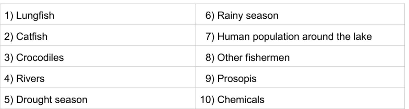
After revising the process of card piling, the second attempt was more successful. First of all, only 10 instead of 23 terms were presented, however still in English. Secondly, the translator was asked to carry out the card piling under researcher's supervision. And thirdly, instead of exploring random cognitive relations between terms, this attempt focused on a ranking of experienced hazards to Lake Baringo. Ten fishermen were asked to sort the terms into three categories, namely “most hazardous”, “less hazardous”, and “least hazardous”. In a second step, they were asked to gradually rank the category “most hazardous”. Terms used for the card piling process were:
Table 1: Terms used for card piling process
1) Lungfish 6) Rainy season
2) Catfish 7) Human population around the lake
3) Crocodiles 8) Other fishermen
4) Rivers 9) Prosopis
5) Drought season 10) Chemicals
Source: author's data analysis (Deichsel fieldwork 2013)
2.3 Data analysis: qualitative content analysis after Philip Mayring
The qualitative content analysis was considered to be the best suitable method for answering most of the previously presented research questions, as the raw material mainly consists of transcribed speech. Content analysis is understood as a “method for the collection of social reality which uses characteristics of a manifest text to indicate the
characteristics of a non-manifest context” [author's transl. from German] (Merten 1995 cf.
Atteslander 2003, 224)
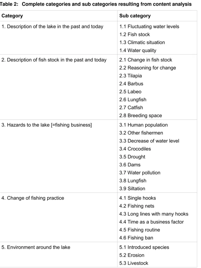
According to Philip Mayring, the main objective of a qualitative content analysis is to analyse (fixed) communication in a systematic manner. Thereby systematic manner stands for a rule-guided procedure, a procedure which is also guided by theory (Mayring 2008, 13). In order to apply a qualitative content analysis after Mayring, the first step is to determine a specific investigation period. For this work the entire period of fieldwork at Lake Baringo, Kenya, and therefore all interviews recorded during that time were considered relevant. The next step is what Mayring calls inductive category development. Mayring defines categories as “aspects of interpretation” which need to be “as near as possible to the material, to formulate them in terms of the material” (Mayring 2000, n.p.). At the core of any content analysis is what follows then, namely the deductive category application. “Deductive category application works with prior formulated, theoretical derived aspects of analysis, bringing them in connection with the text” (Mayring 2000, n.p.). The main idea here is to give explicit definitions, examples and coding rules for each deductive category, determining exactly under what circumstances a text passage can be coded with a category. The category and sub category definitions are put together within a coding agenda2. As Mayring (2000) suggests, all category definitions, text passages, and rules for distinguishing different categories for this work were completed step by step, and revised with the process of analysis. Resulting from this process are the following categories and sub categories which are also the basis for the structure of this paper.
Table 2: Complete categories and sub categories resulting from content analysis
Category Sub category
1. Description of the lake in the past and today 1.1 Fluctuating water levels 1.2 Fish stock
1.3 Climatic situation 1.4 Water quality 2. Description of fish stock in the past and today 2.1 Change in fish stock
2.2 Reasoning for change 2.3 Tilapia
2.4 Barbus 2.5 Labeo 2.6 Lungfish 2.7 Catfish
2.8 Breeding space 3. Hazards to the lake [=fishing business] 3.1 Human population
3.2 Other fishermen
3.3 Decrease of water level 3.4 Crocodiles
3.5 Drought 3.6 Dams
3.7 Water pollution 3.8 Lungfish
3.9 Siltation 4. Change of fishing practice 4.1 Single hooks
4.2 Fishing nets
4.3 Long lines with many hooks 4.4 Time as a business factor 4.5 Fishing routine
4.6 Fishing ban
5. Environment around the lake 5.1 Introduced species 5.2 Erosion
5.3 Livestock Source: author's data analysis (Deichsel fieldwork 2013)
3 Literature review and concepts
In order to approach the subject of this research in all its complexity some key terms and concepts need to be discussed before data analysis and data presentation. As has been said earlier, this study concentrates in particular on local knowledge; it is therefore intended in this section to find out how local knowledge differs from other forms of knowledge, who possess it, and what possibilities local knowledge contains for environmental management strategies. Further the notion of hazard and hazard perception will be portrayed in order to discuss a linkage between hazards, hazard perception and society. And thirdly, the meaning of environmental change in connection to local knowledge and hazard will be a topic of this section.
3.1 Local knowledge
In the discourse regarding the interface between social and ecological systems, some scientists argue that western paradigms and systems of knowledge are currently not able to deal with the full complexity of environmental management (Raymond et al. 2010; Ludwig et al. 2001). It is argued that this is because local stakeholder perspectives are not sufficiently integrated in the development of such management strategies. In order to manage environmental problems, meaning their scope, complexity and uncertainty, it is therefore been requested to take account of different types and sources of knowledge.
Resulting from this argumentation, the current challenge for researchers is “to develop 'user-inspired' and 'user-useful' management approaches” for which local knowledge needs be considered “alongside scientific knowledge” (Raymond et al. 2010, 1766).
Since western paradigms and systems of knowledge are no longer seen as “enough”
(Ludwig et al. 2001, 482), it has been argued that “somehow that knowledge must be integrated with political, economic, social, ethical and religious insight and tempered with respect for human dignity and for the biosphere” (ibid). The biggest challenge for combining different types of knowledge is, however, that there are various perspectives of what constitutes knowledge and of how someone comes to know something. To reach clarity in this matter there have been attempts to develop knowledge categories. With the result that more than one possible way of knowledge categorisation has since been developed, this leads to confusion about the meaning of a category. As a direction-giving overview, Raymond et al. present a simplified version of knowledge categories expressed under three broad headings:
• localised, experimental or indigenous knowledge;
• more formalised 'scientific' knowledge;
• 'hybrid' knowledge (2010, 1767).
The authors summarise the first broad category as 'local knowledge', which they define as
“the informal, lay, personal, often implicit or tacit, but possibly expert knowledge” (Raymond et al. 2010, 1768). The second category, 'scientific' knowledge, is specified as “the often explicit knowledge that has been derived from applying more formal methods that aim to increase rigour in relation to different perceptions on validity and reliability” (ibid, 1768f.).
And thirdly, 'hybrid' knowledge is described as “the new understandings which emerge through the integration of different types of knowledge (such as local and scientific) and/or through multi-, inter-, or trans-disciplinary research” (ibid, 1769). Looking at the explicit use of inverted commas when classifying categories of knowledge, it can be reasoned these category terms are not to be understood as absolute terminology and that categories can overlap. For example, scientific findings as accurate as they may be, are always interpreted by individuals who make sense of them in relation to what they know and to what they have experienced in their own past. “This implies that knowledge is inherently personal with different people interpreting the same information in different ways” (ibid, 1769).
In her work on local knowledge in the environment-development discourse, Anja Nygren states that in order to emphasise a difference between expert knowledge and local knowledge a discourse has long been utilised which featured sharp contrasts like
“rational/magical, universal/particular, theoretical/practical and modern/traditional” (Nygren 1999, 271). Thereby the capacity of local people to innovate, systematise and transfer knowledge was portrayed as limited in contrast to scientific knowledge which was considered “rigorous and cumulative” (ibid, 273).
Nygren further argues that in addition to the interpretation of knowledge, the production of all knowledge is also much influenced by personal perspectives and ideologies. Personal perspectives are in turn shaped by contextual factors and the values of the society in which a person is embedded:
There was little recognition of the fact that in practice science is ‘achieved’ in much the same way as other forms of knowledge – through social construction and negotiation (ibid).
For this study the term local knowledge is used in reference to knowledge obtained mainly through living in a certain environment, through dealing with changes and challenges within this environment and through observing them. As Antweiler states:
[Local knowledge] is neither indigenous wisdom nor simply a form of science, but a locally situated form of knowledge and performance found in all changing social and natural environments (2004, 1).
Local knowledge can thus also stand for skills and capabilities as they are acquired and applied by people with respect to their local objectives, situations and problems: local communities know of materials and energy sources available to them on site which can be
consulted for problem solving and other practices. In reference to Antweiler, local in this context is not to be understood as exclusively referring to a location, but rather as knowledge being culturally and ecologically situated (2004, 2).
Because local knowledge can be regarded as culturally and ecologically situated, it is assumed that not necessarily all members of a community share a comprehensive knowledge system. Different statuses and allocation of tasks within a community (due to age, gender etc.) impact areas and transfer of knowledge (Bicker et al. 2004, xi). Further, local knowledge informed activities are not necessarily sustainable, or socially just. “Such knowledge is not only cognitive, but entails emotive and corporeal aspects” (Antweiler 2004, 10).
A decision model “for the incorporation of indigenous knowledge into development projects”
by Sillitoe & Barr shows how agencies can effectively make connections between local people’s understanding and practices, and research and development approaches. The model proposes:
▪ facilitating meaningful communication with local people;
▪ understanding and valuing local people’s knowledge and practices;
▪ identifying research or development initiatives to address jointly perceived problems;
▪ advancing participatory research to identify and tackle constraints more effectively;
and
▪ discussing with people the social, environmental and other consequences of any action (Sillitoe et al. 2004, 59).
What might sound rather obvious at first, however, seems necessary to point out when considering the apparent lack of incorporated local knowledge, especially in wetland management. Thereby the model assumes that by paying attention to local perceptions and practices, research and development initiatives are more likely to meet people’s needs as well as they are more likely to create acceptance for change among the local population.
3.2 Hazards and hazard perception
The term hazard plays an important role in various disciplines from technical sciences to social sciences, as well as in various professional contexts. Consequently, there are many definitions for the term (Paul 2011, 2).
Concepts given in literature often distinguish between natural hazards and technological i.e. man-made hazards. The International Federation of Red Cross and Red Crescent Societies (IFRC), for example, define hazards for their work in disaster management as follows:
Natural hazards are naturally occurring physical phenomena caused either by rapid or slow onset events which can be geophysical (earthquakes, landslides, tsunamis and volcanic activity), hydrological (avalanches and floods), climatological (extreme temperatures, drought and wildfires), meteorological (cyclones and storms/wave surges) or biological (disease epidemics and insect/animal plagues).
Technological or man-made hazards (complex emergencies/conflicts, famine, displaced populations, industrial accidents and transport accidents) are events that are caused by humans and occur in or close to human settlements. This can include environmental degradation, pollution and accidents, technological or man-made hazards (complex emergencies/conflicts, famine, displaced populations, industrial accidents and transport accidents) (IFRC 2011).
Here, natural hazards and man-made hazards are initially viewed as two separate phenomena. For instance, droughts and floods are allocated to the category of natural hazards whereas environmental degradation is categorised as man-made hazard. Thus, it is a definition which does not immediately point out the role of humans in causing or amplifying the impacts associated with hazards. As a counter-argument for this approach, it can be said that floods, to give one example, can originate either from a natural change in meteorological conditions, or from human action, such as deforestation, intensive use of land or failure in dam construction (Paul 2011, 3). Natural and technological hazards should hence not be seen as completely disjointed.
A rather new development in the classification of hazard and disaster recognises a linkage between hazards and a society, which Paul describes as a “major shift” (Paul 2011, 21).
Only a decade ago, he claims, it was common practice to neatly divide between events caused by nature and those caused by humans. As seen earlier, the IRFC continues to hold on to this disposition, whereas in more recent research, hazards and disasters are viewed as “continuum of physical/environmental, social and technological systems” ranging from
“extreme natural events to technological failure to social disruption to terrorism” (Paul 2011, 21).
There is therefore little doubt that humans affect natural processes and often contribute to hazards. But hazards are more than the actual disastrous event with all its consequences.
They also mean the probability of occurrence of a potentially damaging phenomenon – hazards have “the potential to harm individuals or human systems” (Pelling 2003, 5). Or as Smith puts it, they are “naturally occurring or human-induced process(es) or event(s) with the potential to create loss, i.e. a general resource of danger” (Smith 1996, 5). In both definitions, again the aspect of potential loss and harm to individuals or a whole society is key. This leads to the question of perception of hazards.
As discussed above, looming threats can be as much of a hazard as the actual event. As a consequence, everyday hazards or chronic disasters are felt as long-term stresses.
Examples of everyday hazards are poor sanitation, unfit housing and polluted air among others (Pelling 2003, 15). Apart from the living conditions, there are numerous factors that influence perception:
• Individual characteristics. Wealth, household status and gender can influence the risk of hazard exposure. These individual characteristics can also influence a person's ability to mitigate an imminent loss or cope with its aftermath;
• Cultural and community characteristics. For example the existence or absence of strong social safety nets or conflict resolution mechanisms;
• Culturally determined gender roles. Differentiated roles between men and women play a guiding factor on how an individual perceives and responds to looming danger.
(Nduru et al. 2012, 137)
Hazards associated with climate variability are plentiful and multifaceted. That is why
“indigenous perceptions of sustainable resource management and of environmental degradation give a good idea of emic accounts of environmental vulnerability” (Bollig 2006, 12). In their work on climate variability risks, perceptions and coping mechanisms in Kenya, Nduru and Kiragu support this claim in stating that understanding perceptions about those climate related hazards are “crucial in determining virtually everything that rural people especially in arid and semi-arid areas do” (Nduru et al. 2012, 138).
As mentioned earlier, culture and community characteristics strongly influence a person's hazard perception. This is also true for the willingness to participate in innovations initiated and introduced from outside. Until local people gain respect for an initiative, they will not adopt it as a coping mechanism, or as a form of mitigation against a looming risk. As the International Lake Environment Committee (ILEC) state “people are more easily convinced by their neighbours’ experiences and tend to trust those they live with rather than outsiders”
(ILEC 2005, 49).
3.3 Environmental change
When searching for definitions of environmental change, most information available is directly linked to climate change and global warming. It should be pointed out, however, that climate change is only a part of environmental change as a whole, which covers change in the lithosphere, landscape (geomorphology), hydrological systems (including the oceans and ice), vegetation and fauna, as well as climate change (Wainwright 2011, 14).
Much of the debates on global environmental change have been based around the activities of the Intergovernmental Panel of Climate Change (IPCC). The IPCC is a joint initiative of the World Meteorological Organization (WMO) and the United Nation Environment Programme (UNEP) which has so far published four assessment reports since its
establishment in 1988. Corresponding Slaymaker et al summarise the conclusions of the latest report on climate change (published 2007) as follows:
• warming of the climate system is apparent;
• palaeoclimate information supports the interpretation that the warmth of the last half century is unusual in at least the previous 1300 years;
• most of the observed increase in globally averaged temperature since the mid twentieth century is very likely due to the observed increase in anthropogenic greenhouse gas concentration […] (Slaymaker et al. 2009, 1)
But what does change actually mean? By dictionary definition, change is “an act or process through which something becomes different; substitution of one thing for another; an alteration or modification” (Oxford English Dictionary 2013b) It becomes clear that the character of any change may take on a number of forms. In the context of environments, for example, climate variations may be periodic (hence predictable), quasi-periodic (only predictable in a broader sense) or non-periodic. (Bradley 1999, 11ff.) Changes may also occur in a number of less obvious ways. “For example, the frequency of an oscillation may vary, or the magnitude of the variability around the mean may increase or decrease”
(Wainwright 2011, 15).
The spatial scale of our observations about our environment also affects the way in which we perceive changes in the global environment. Research strategies can commonly be allocated to either top-down or bottom-up approaches. Top-down approaches generally require conceptual interpretations of global systems. Bottom-up approaches involve an integration of local data from a large number of settings. “Only by the convergence of the interpretations possible from these two approaches can we be confident that our understanding is reasonable” (Wainwright 2011, 15).
On a local level, our perceptions of change are generally guided by experiences. “We feel comfortable with the daily, seasonal and to a certain extent interannual changes, because those are the ones of which we have direct experience and memory” (Wainwright 2011, 14).
Changes on a decadal scale are less obvious, but still kept in a collective memory. Beyond the length of a single lifetime, however, it is argued that we find it increasingly difficult to perceive changes because they rely on the assimilation of information that is much more indirect (ibid). When analysing human aspects of environment change, it is important to consider the differences between direct and indirect impacts. “Often, the most important effects are those where human activities have caused feedbacks in other parts of the environmental system” (ibid).
4 Context of Lake Baringo
4.1 Climatic situation and environment
Lake Baringo is located in a semi-arid zone which has all characteristic features of arid and semi-arid lands (ASALs). These are low erratic rainfall, periodic droughts and different associations of vegetative cover and soils (IISD 2010). The lake experiences very high annual evaporation rates, compared to an annual rainfall of 450-900 mm. Being in the Intertropical Convergence Zone (ITCZ) the lake has two rainy seasons with long rains in the months of April to August, whereas the short rains fall from October to November (Hickley et al. 2004; Odada et al. 2006). Variation in rainfall occurs on a range of time scales, including El Nino and La Nina periods, i.e. every 5–7 years (Ogola et al. 2011).
With its islands, the swamps, the surrounding bushland, semi-desert strip vegetated with Acacia and the west cliffs of the Laikipia plateau, Lake Baringo is considered a globally unique paradise for ornithologists. Here over 500 species of birds have been observed. In addition, crocodiles and hippos can be found in the lake. (Hosang 2007) The streams flowing into Lake Baringo originate from humid and sub humid hill slopes, where the annual rainfall is over 1000 mm. As will be discussed later (see 5.2), these streams are the major source of recharge for the lake. Due to deforestation in the water recharge areas, groundwater recharge has decreased, with streams drying up more often during the dry seasons, whereas they cause flash floods during the rainy seasons. As a result of the floods, loss of property and displacement of people have been prevalent in the lower reaches of the basin. (Odada et al. 2006) Another risk to the lake is siltation due to soil erosion (see 5.2). The soils are clay and clay loams and the risk of soil erosion is high because of the soil properties: “clay fills pores or seals thesurface giving low infiltration capacity” (Hickley et al. 2004).
According to the Kenyan Ministry of Devolution and Planning (MoDP), the primary policy challenge in the Baringo area is how to ensure food and nutrition security in a sustainable manner. Since the environments in ASALs are prone to drought, access to and control over critical livelihood resources such as land is insecure, and climatic change will increase this unpredictability (MoDP 2011).
4.2 Lake Baringo as a Ramsar Site
In 2002 Lake Baringo was declared a Ramsar Site, which gave official recognition to the lake as a “Wetland of International Importance” (Ramsar Convention Secretariat 2002). The Convention on Wetlands (Ramsar, Iran, 1971) is an intergovernmental, non-UN-related treaty whose mission is “the conservation and wise use of all wetlands through local, regional and national actions and international cooperation, as a contribution towards achieving sustainable development throughout the world” (Ramsar Convention Secretariat
2006). Specifically the treaty encourages member countries to stop the progressive intrusion and loss of wetlands by recognising the fundamental ecological functions of wetlands as well as their economic, cultural, scientific, and recreational value.
Wetlands play a significant role in the livelihoods of rural communities (Wellington et al.
2010; Frenken et al. 2002). They store water during the wet season and release it during the dry season. Therefore wetlands support human welfare such as livestock grazing and watering, water supply, crop production and for this paper the most important aspect, fishing (Gichuki et al. 2006). Furthermore, wetlands are important for tourism due to their unique landscape and rich biodiversity. For Lake Baringo, it has been remarked that “local fisheries are particularly important for sustainable development of the local communities, for both economic and sport fishing” (Ramsar Convention Secretariat 2012).
As has been highlighted, Lake Baringo as a Ramsar Site has a great value and needs corresponding management. According to the National Environmental Management Authority (NEMA) adopting and implementing Ramsar convention guidelines has assisted in the conservation of some wetlands, yet many of Kenya's wetlands continue to experience pressures and threats from both natural events and human activities. NEMA also detected that Kenya does not have a comprehensive wetland policy. As a result, wetland management issues continue to be undertaken in a disjointed manner (NEMA 2012).
Looking at the management difficulties on the political level one might wonder about the role of local people organising their immediate environment and sustain their livelihoods. A study on socio-economic values and traditional strategies of managing wetland resources in Lower Tana River, Kenya, has shown again that major management decisions in Kenya are usually implemented by government departments and institutions – with very little local community participation or involvement (Terer et al. 2004). As a result local expertise will seldom find recognition in management plans of such sites.
Wetland systems are vulnerable and particularly susceptible to changes in quantity and quality of water supply. Reducing pollution, controlling introduced vegetation, and protecting wetland biological diversity are important examples of how to maintain and improve the resiliency of wetland ecosystems (Erwin 2009). For such endeavours, incorporating local knowledge could help greatly in order to identify stress factors.
4.3 Means of income in the Baringo area
As already mentioned, the study area is characterised by ecological stresses which result in economic challenges for the population. Concretely, recurrent droughts, inadequate freshwater and firewood, inadequate infrastructure, poor market access, insecurity, poverty and high vulnerability to diseases are very prominent and cause demanding living conditions (Ogola et al. 2011, 4225). According to the Kenyan National Council for Population and Development (NCPD), poverty in Baringo District is estimated to affect 35%
of the total population (NCPD 2005, 7). However, the World Bank states in their 2008 assessment on poverty and inequality in Kenya that even 40-50% of the district's population live below the poverty line of USD 1.25 per day (World Bank 2008, 26). Within the district, poverty is more pronounced in the rural areas especially in the lower zones. Non-diversified income-earning activities have been mentioned as a cause creating this situation (NCPD 2005, 7). The main economic activities in the region are nomadic pastoralism, agro- pastoralism, bee keeping, fishing, local aloe production, irrigated and rain fed agriculture, and tourism (Ogola et al. 2011, 4225). Three of these income activities related to the scope of this study shall now be viewed.
4.3.1 Fishing
Fishing has functioned as an important survival strategy for struggling agrarian and pastoral communities. But it is also known as a seasonal activity for those (agro-) pastoralists more temporarily involved in herding or cultivation elsewhere. According to Anderson and Broch- Due this flexibility is due to the fact that the equipment needed to set up fishing is rather simple (1999, 60). The authors continue arguing that African lakes therefore contribute significantly to poverty reduction and food security. “They are a source of dietary proteins and water, they provide revenue through fish harvest, export and tourism, and are used as transportation avenues. They also provide water for irrigation, agriculture and hydro-power projects” (El-Khanater et al. 2010, 3). During this century, though, African lakes have experienced declines in fish catches, reductions in fish species diversity, and deterioration in water quality which is especially true for Lake Baringo. As major challenges to fishery resources in Africa, Ogutu-Ohwayo and Baliwra list the following:
(i) large lake basin populations; (ii) unsustainable fishing practice; (iii) species introductions; (iv) loss of aquatic biodiversity; (v) pollution and eutrophication; (vi) invasive weeds; (vii) inadequate policy and legal regimes; (viii) inadequate institutions, institutional mechanisms and governance, including stakeholder commitment and participation; and (ix) inadequate and unsustainable funding mechanisms (2006, 219)
When characterising the main challenges for fishery resources in Lake Baringo, Odada et al. agree with most points listed above. Especially the growing population in Kampi ya Samaki was pointed out as contributing to fluctuations in fish stock of Lake Baringo.
Because of increasing fishing activities within the last 40 years, the village has transformed into a centre for trade; and this over-dependency on fish as a resource has caused severe decline in fish population. (Odada et al. 2005)
In order to improve fish stocks, a voluntary moratorium on fishing was implemented in 2001.
The lake was alarmingly low that year and the fish stock was dwindling, thus the fishers experienced losses in income. By accepting the moratorium, the fishers of Lake Baringo
After two years, the size of Tilapia has increased by 100 percent, which has, according to ILEC, strengthened local support for the fishing rules (ibid).
4.3.2 Agriculture
According to the Kenyan National Coordination Agency for Population and Development (NCAPD), most of the labour force in the Baringo District is unskilled and semi-skilled. The income of the district is therefore mainly derived from sales of livestock and agricultural products. Agriculture is thus important for poverty reduction and food security in the area.
(NCAPD 2005) Throughout the world, agriculture is a commonly associated feature of wetlands. Conversely, many wetlands are threatened by agricultural practices, which, for instance, modify the hydrological regimes on which wetlands depend, and hence, the ecological character of wetlands and other benefits they provide, are being altered (McCartney et al. 2010).
For Lake Baringo the ILEC observed that the shrinking of the lake is (at least partly) happening because of excessive water withdrawal for upstream irrigation (ILEC 2005, 23).
As mentioned earlier, the wise use of wetland principle, established by the Ramsar Convention, has not been fully put into practice in Kenya. The essence of the principle is the maintenance of a wetland's ecological character within the context of a sustainable development (Ramsar Convention Secretariat 2006). However, the realisation of this objective would not end the misery of the wetland agriculture as Wellington et al. state since there is an ongoing debate between conservation and development approaches:
A pure conservation strategy that aims at protecting the wetland leads to substantial reductions in economic welfare of the local population unless their livelihood sources are diversified into alternative non-farm employment and income options […]
Therefore, improving the capacity of rural farmers to adapt to climate change, especially drought is important to reduce pressure on wetland resources (Wellington et al. 2010, 1577)
Lake Baringo with its low water level is particularly vulnerable to changes in quantity and quality of water supply. In order to reduce the pressure on the lakes it would be necessary to lessen water withdrawal from the streams that drain the lake. This is not a sufficient solution by itself, when one also considers economic welfare of the local smallholders and the socio-economic situation of the area.
4.3.3 Tourism
The lake is an important tourist attraction because of its rich biodiversity, which comprises a unique variety of birds, as well as hippos and crocodiles. According to Little, the development of Baringo's tourist industry since the 1970s, has provoked interest in conservation programmes: “[b]ecause the maintenance of the resource base is critical to
sustain the region's wildlife […], there is an incentive to improve local land use” (Little 1992, 172). Through tourism activities, the area has further been opened to other regions, both nationally and internationally. This has promoted business enterprises. Burnett and Rowntree list two types of tourists from outside of Kenya, namely the “pre-packaged safari travellers” and the “serious birder” (Burnett et al. 1990, 168). A third group mentioned, not directly declared as tourists, yet who are also of economic importance to the area, are scientists. Scientists often employ locals for menial work and both tourists and scientists are known to make demands on shop owners as well as on leisure facilities. Consequently, the supply has adapted to the demand as local tour guides offer tours on the lake and on land for “tourist prices”. Especially during closed fishing seasons, local fishermen use tourist tours on the lake as an additional source of income. The Tugen fishing boats, as seen during fieldwork however, are not suitable for transporting passengers as they can only fit one person (see 5.1).
5 Data presentation
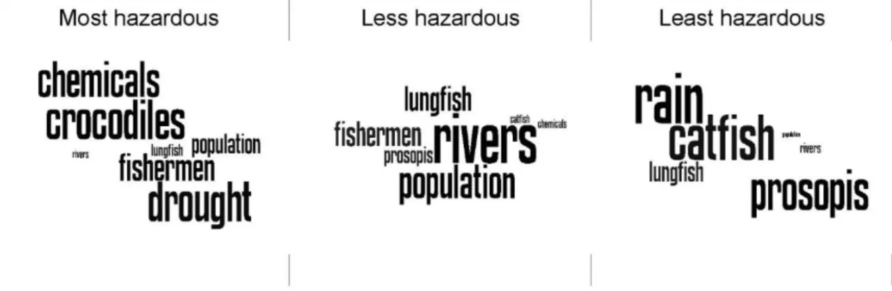
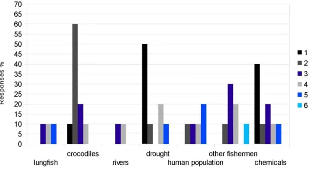
For a clear understanding, two formats of visualisation have been created for data presentation; Figures 1a/2a translate card piling results into bar graphs which give information about percentaged distribution of votes. In Figures 1b/2b the same results have been taken to develop a so called word cloud or visually weighted list which enables an easy access to data material.
Outcomes from qualitative content analysis are presented through periphrases and direct quotes in each section.
Figure 1a. Ranks of major hazards to Lake Baringo (n=10)
Ranks present (1) most hazardous, (2) less hazardous, and (3) least hazardous.
Source: author's data analysis (Deichsel fieldwork 2013)
Figure 1b. Visually weighted list of major hazards to Lake Baringo (n=10) Source: author's data analysis (Deichsel fieldwork 2013)
Figure 2a. Gradual ranks of the category “most hazardous” (n=10)
Ranks present (1) most hazardous, (2) 2nd-most hazardous, (3) 3rd-most hazardous, (4) 4th-, (5), 5th -,(6) 6th-most hazardous.
Source: author's data analysis (Deichsel fieldwork 2013)
Figure 2b. Visually weighted list of category "most hazardous" (n=10) Source: author's data analysis (Deichsel fieldwork 2013)
5.1 Tugen fishing practice today and in the past
In their work “Management challenges of freshwater fisheries in Africa” Richard Ogutu- Ohwayo and John Balirwa point out that fishing efforts on most of African lakes were originally low due of the small number of fishermen, poor fishing crafts, inefficient gear, and limited markets. However, the fishing business “on virtually all the lakes” (Ogutu-Ohwayo et al. 2006, 219) have since increased, because of “growing human population, improvement of fishing crafts, introduction of more efficient fishing gear and methods, and expansion of markets with improved communication” (ibid). This section will show that the authors' statement is also true for Tugen fishery at Lake Baringo. Yet, another complex topic needs to be addressed before evaluating the development of Tugen fishing practice, namely how the Tugen came to pursue fishery in the first place.
Excursus: Tugen in the Baringo area
The Tugen were, and partly still are agro-pastoralists who inhabited the high lands of the Rift Valley (Tugen Hills) until resettlement strategies under British colonial rulers moved them to the lowlands near the lake (Little 1992, 7). According to anthropologist Peter Little, two larger regional systems operated in the area in pre-colonial times, which enclosed many of the East Africa's important pastoral and agricultural groups. The first was the central Rift Valley system which included the Maa-speakers (Purko Maasai, Il Chamus etc.) as well as Kalenjin groups (Tugen and Nandi) and Bantu groups (Kikuyu and Kamba). The second region was the Lake Turkana basin, which included the Turkana, Dassenetch, Samburu, Boran and other predominantly pastoral groups. The two systems were integrated through networks of exchange. The advent of colonialism, however, drastically altered these regional relationships as these large regional systems were fragmented by administrative boundaries. The Colonial management established an administrative area around Lake Baringo (similar to today’s Baringo District) composed of the Tugen, the Pokot and the Njemps. In Baringo each of the major ethnic groups occupied new lands in the 20th century because of military and resettlement policies by the colonial rulers. The Tugen, as already noted, were moved from the hills into lowlands grazing areas which had been used by Maa- speaking groups throughout the 19th century. (ibid, 17ff)
Unfortunately, no reference could be found stating exactly when the Tugen took up fishing, however it seems plausible that the relocation to an area near Lake Baringo influenced the process.
Tugen fishing practice today and in the past, continued:
The fishermen of Ngenyin Beach start their work routine every morning at around 7 a.m. It takes about half an hour to walk from their village to the landing site where all fishing boats are kept on the lake shores over night to dry. The material used for boat construction is