Climate Change 2007:
The Physical Science Basis
1. Human and Natural Drivers of Climate Change (CC) 2. Direct Observations of Recent CC
3. A Paleoclimatic Perspective
4. Understanding and Attribution CC
5. Projections of Future Changes in Climate
Quelle: IPCC-AR4-wg1_SPM: Scientific Basis, (2007-0202).
Quelle:
GOTO Summary for Policy Makers:
http://ipcc-wg1.ucar.edu/wg1/docs/WG1AR4_SPM_PlenaryApproved.pdf
Aus dem neuen (2007-0202) IPCC Report:
Bilder aus
IPCC: AR4 wg1 - SPM
IPCC-Sprech:
IPCC = Intergovernmental Panel on CC CC = Climate change
AR4 = Assessment Report 4
wg1 = working group 1: Scientific Basis
SPM: = Summary for Policy Makers , TS = Technical Summary
SPM-1: Changes in Greenhouse Gases SPM-2: Radiative Forcing Components
SPM-3: Changes in Temperature, Sea Leve and Northern Snow Cover SPM-4: Global and Continental Temperature Change
Models with only natural and models with both forcings
SPM-5: AOGCM: Model Projections of Surface Temperature SPM-6: Projected Patterns of Precipitaion Changes
SPM-7: Model Global Averages of Surface Temperature
1. Human and Natural Drivers
of Climate Change (CC)
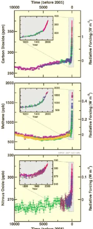
FIGURE SPM-1.
Atmospheric concentrations of
carbon dioxide , methane and nitrous oxide
over the last 10,000 years (large panels) and since 1750 (inset panels).
Measurements are shown from ice cores
(symbols with different colours for different studies) and
atmospheric samples (red lines).
The corresponding
radiative forcings
are shown
on the right hand axes of the large panels.
{Figure 6.4}
Quelle: IPCC-AR4-wg1_SPM: Scientific Basis, Bild SPM-1, (2007-02)
CO 2
10.000
vor heute 5.000
vor heute
2005 AD
W/m2 ppm
10.000
vor heute 5.000
vor heute
2005 AD
CH 4
W/m2 ppb
N 2 O
W/m2 ppb
Radiative Forcing Components
Quelle: IPCC-AR4-wg1_SPM: Scientific Basis, Bild SPM-2, (2007-02)
LOSU = Level of scientific Understanding
FIGURE SPM-2.
Global-average radiative forcing (RF) estimates
and ranges in 2005 for anthropogenic carbon dioxide (CO2), methane (CH4), nitrous oxide (N2O) and other important agents and mechanisms,together with the typical geographical extent (spatial scale)
of the forcing and the assessed level of scientific understanding (LOSU).
The net anthropogenic radiative forcing and its range are also shown.
These require summing asymmetric uncertainty estimates from the component terms, and cannot be obtained by simple addition.
Additional forcing factors not included
here are consideredto have a very low LOSU.
Volcanic aerosols contribute an additional natural forcing
but are not included in this figure due to their episodic nature.
Range for linear contrails does not include other possible effects of aviation on cloudiness. {2.9, Figure 2.20}
2. Direct Observations of Recent CC
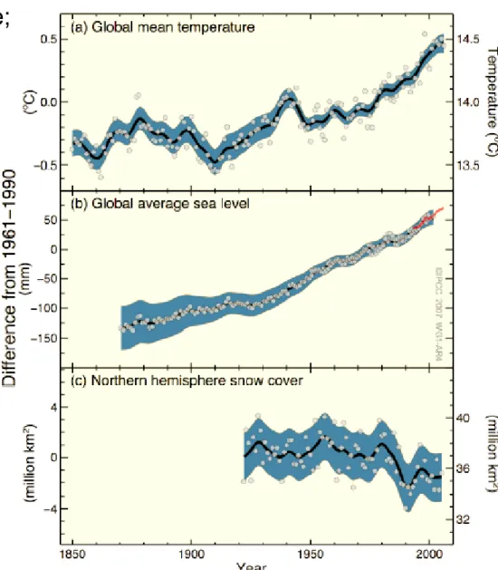
Observed changes in
(a) global average surface temperature;
(b) global average sea level rise from tide gauge (blue)
and satellite (red) data and (c) Northern Hemisphere
snow cover for March-April.
All changes are relative to corresponding averages for the period 1961-1990.
Smoothed curves represent decadal averaged values
while circles show yearly values.
The shaded areas are the
uncertainty intervals estimated from a comprehensive analysis of known uncertainties (a and b) and from the time series (c).
{FAQ 3.1, Figure 1,
Figure 4.2 and Figure 5.13} Quelle: IPCC-AR4-wg1_SPM: Scientific Basis, Bild SPM-3, (2007-02)
Observed changes in Temperature, Sea Level and Snow Cover
1850 1900 1950 2000
1850 1900 1950 2000
Quelle: IPCC-AR4-wg1_SPM: Scientific Basis, Tabelle SPM-0, (2007-02)
Quelle: IPCC-AR4-wg1_SPM: Scientific Basis, Tabelle SPM-1, (2007-02)
Extreme Weather Events
(a) See Table 3.7 for further details regarding definitions (b) See Table TS-4, Box TS-3.4 and Table 9.4.
(c) Decreased frequency of cold days and nights (coldest 10%) (d) Increased frequency of hot days and nights (hottest 10%) (e) Warming of the most extreme days and nights each year (f) Magnitude of anthropogenic contributions not assessed.
Attribution for these phenomena based on expert judgement rather than formal attribution studies.
(g) Extreme high sea level depends on mean sea level and
on regional weather systems. It is defined here as the highest 1% of hourly values of observed sea level at a station for a given reference period.
(h) Changes in observed extreme high sea level closely follow the
changes in mean sea level {5.5.2.6}. It is very likely that anthropogenic activity contributed to a rise in mean sea level. {9.5.2}
(i) In all scenarios, the projected global mean sea level at 2100 is higher than in the reference period. {10.6}. The effect of changes in regional weather systems on sea level extremes has not been assessed.
3. A Paleoclimatic Perspective
1. Paleoclimate information supports the interpretation that the warmth of the last half century
is
unusual in at least the previous 1300 years.
2. The last time the polar regions were significantly warmer than present for an extended period (about 125,000 years ago),
reductions in polar ice volume
led to
4 to 6 metres of sea level rise
. {6.4, 6.6}4. Understanding and Attribution CC
Global and Continental Temperature Change
Quelle: IPCC-AR4-wg1_SPM: Scientific Basis, Bild SPM-4, (2007-02)
Models with
only natural
and withboth
forcingsFIGURE SPM-4.
Comparison
of
observed
continental- and global-scale changes in surface temperature with results simulated byclimate models
using
natural and anthropogenic forcings.
Decadal averages of observations are shown for the period 1906–2005 (black line) plotted against the centre of the decade and
relative to the corresponding average for 1901–1950.
Lines are dashed where spatial coverage is less than 50%.
Blue shaded bands
show the 5–95% range for 19 simulations from 5 climate models usingonly the natural forcings
due to solar activity and volcanoes.Red shaded bands
show the 5–95% range for 58 simulations from 14 climate models usingboth natural
andanthropogenic forcings.
{FAQ 9.2, Figure 1}Quelle: IPCC-AR4-wg1_SPM: Scientific Basis, Bild SPM-4, (2007-02)
Models with
only natural
and withboth
forcings5. Projections of
Future Changes in Climate
Quelle: IPCC-AR4-wg1_SPM: Scientific Basis, Tabelle SPM-2, (2007-02)
Projected Surface Warming and Sea Level Rise
AOGCM Projections of Surface Temperatures
Quelle: IPCC-AR4-wg1_SPM: Scientific Basis, Bild SPM-5, (2007-02)
FIGURE SPM-5. Projected surface temperature changes for the early and late 21st century relative to the period 1980–1999.
The central and right panels show the Atmosphere-Ocean General Circulation multi-
Model average projections for the B1 (top), A1B (middle) and A2 (bottom) SRES scenarios averaged over decades 2020–2029 (center)
and 2090–2099 (right).
The left panel shows corresponding uncertainties as
the relative probabilities of estimated global average warming
from several different AOGCM and EMICs studies for the same periods.
Some studies present results only for a subset of the SRES scenarios, or for various model versions.
Therefore the difference in the number of curves, shown in the left-hand panels, is due only to differences in the availability of results.{Figures 10.8 and 10.28}
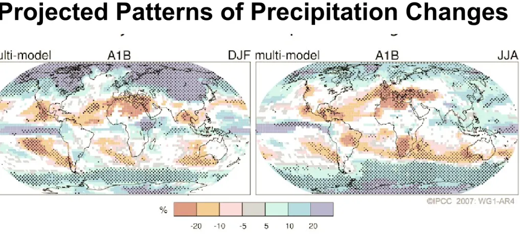
Projected Patterns of Precipitation Changes
FIGURE SPM-6. Relative changes in precipitation (in percent) for the period 2090–2099, relative to 1980–1999.
Values are multi-model averages based on the SRES A1B scenario for December to February (left) and June to August (right).
White areas are where less than 66% of the models agree in the sign of the change and stippled areas are where more than 90% of the models agree in the sign of the change.
{Figure 10.9}
Quelle: IPCC-AR4-wg1_SPM: Scientific Basis, Bild SPM-6, (2007-02)
Global Surface Warming 1900 -2100
Quelle: IPCC-AR4-wg1_SPM: Scientific Basis, Bild SPM-7, (2007-02)
Figure SPM-7.
Solid lines are multi-model global averages of surface warming (relative to 1980-99)
for the scenarios A2, A1B and B1, shown as continuations of the 20th century simulations.
Shading denotes the plus/minus one standard deviation range of individual model annual means.
The number of AOGCMs run for a given time period and scenario is indicated by the coloured numbers at the bottom part of the panel.
The orange line is for the experiment where concentrations were held constant at year 2000 values.
The gray bars at right indicate the best estimate (solid line within each bar) and the likely range assessed for the six SRES marker scenarios.
The assessment of the best estimate and likely ranges in the gray bars includes the AOGCMs in the left part of the figure,
as well as results from a hierarchy of independent models and observational constraints (Figs. 10.4 and 10.29)
Aktuell: die NASA – WeltTemperaturkarte 2006
NASA 2007-02:
Welttemperatur 2006
BQuelle: SpektrumDirekt SD865173 Bild 1: 2006 funftwärmstes Jahr seit Aufzeichnungsbeginn“, SD865173….doc
Wärmer seit 1890 AD als 2006 AD waren nur: 2005,1998,2002 und 2003 AD
Arktis bis zu +3.8 [K]
N-Europa, Kanada
China +1,5 bis +2,5 [K]
Antarktische Halbinsel +1,5 bis +2,5 [K]
Sonstige Antarktis: kälter