ORIGIN AND MIGRATION OF PETROLEUM IN THE GIDGEALPA RIDGE AREA,
COOPER/EROMANGA BASINS, SOUTH AUSTRALIA
A thesis presented by
CHRISTIAN OLIVIER EDUARD HALLMANN
To the Geological Institute
In partial fulfilment of the requirements for the degree of DIPLOM
In the subject
GEOLOGIE-PALAEONTOLOGIE
Diplomarbeit Diploma thesis
University of Cologne Cologne, Germany
WS ’04 / ’05
ORIGIN AND MIGRATION OF PETROLEUM IN THE GIDGEALPA RIDGE AREA,
COOPER/EROMANGA BASINS, SOUTH
AUSTRALIA
Christian O.E. Hallmann
_________________________________________
Nothing in nature is random…
A thing appears random only through the incompleteness of our knowledge
Spinoza, Ethics I ____________________________________________________
CONTENTS
Contents
Contents I
List of Figures IV
List of Tables VII
Declaration VIII
Acknowledgements IX
Abstract (English) X
Abstract (German) XII
CHAPTER ONE INTRODUCTION 1
1.1 Scope of this thesis 2
1.2 Location of the study area 3 1.3 History of petroleum exploration 4 CHAPTER TWO REGIONAL GEOLOGY 5 2.1 Geological evolution of Australia 5
2.2 Tectonic setting 6
2.2.1 Warburton Basin 7
2.2.2 Cooper Basin 9
2.2.3 Eromanga Basin 9
2.2.4 Study area 9
2.3 Sedimentary record 10
2.3.1 Warburton Basin units 10
2.3.2 Cooper Basin units 12 2.3.3 Eromanga Basin units 16 CHAPTER THREE PETROLEUM GEOLOGY 19
3.1 Introduction 19
3.2 Source rocks 19
CONTENTS
3.3 Reservoirs 20
3.4 Traps 21
3.5 Oils 21
3.6 Thermal and subsidence history and expulsion events 22
3.7 Study area 23
CHAPTER FOUR EXPERIMENTAL 26
4.1 Sample selection 26
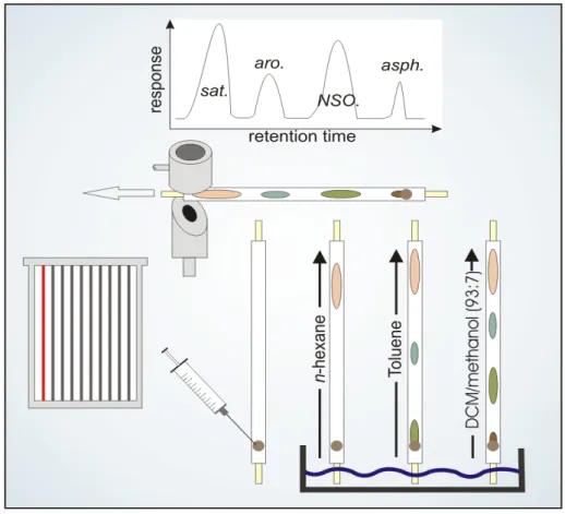
4.2 Sequential flow through extraction 28
4.3 Medium pressure liquid chromatography 30
4.4 Iatroscan TLC-FID 32
4.5 Solid phase extraction 33
4.6 Gas chromatography and mass spectrometry 34
CHAPTER FIVE SOURCE FACIES 36
5.1 n-Alkane distribution 36
5.2 Isoprenoid biomarkers 37
5.2.1 Pristane and phytane 37
5.2.2 Results and discussion 39
5.2.3 Hopanoids 39
5.2.4 Steroids 40
5.2.5 Results and discussion 42
CHAPTER SIX CARBAZOLE DISTRIBUTION 44
6.1 Introduction 45
6.2 Maturity, Expulsion and Facies controls 47
6.3 Warburton Basin input 56
6.4 Migration fractionation 61
6.5 Synopsis 66
CHAPTER SEVEN FILLING AND MIXING 68
7.1 Aromatic hydrocarbon parameters 68
7.1.1 Methylphenanthrenes 68
7.1.2 Araucariacaean markers 69
7.1.3 Maturity discrepancies 70
7.2 Eromanga Basin reservoirs 73
7.2.1 Filling of the Namur Sandstone 74
CONTENTS
7.2.2 No second charge for Birkhead reservoirs 75 7.2.3 Hutton Sandstone – a site of active oil mixing 77 7.2.4 The Poolowanna Fm. – no access for Jurassic oils 81
7.3 Cooper Basin reservoirs 82
7.3.1 Warburton Basin influx 82 7.3.2 Family 1 versus Family 2 oils 86
7.4 Synopsis 87
CHAPTER EIGHT CONCLUSIONS 92
REFERENCES 95
APPENDICES
I Abbreviations and units II Data tables
III Flow chart
LIST OF FIGURES
List of Figures
Chapter 1
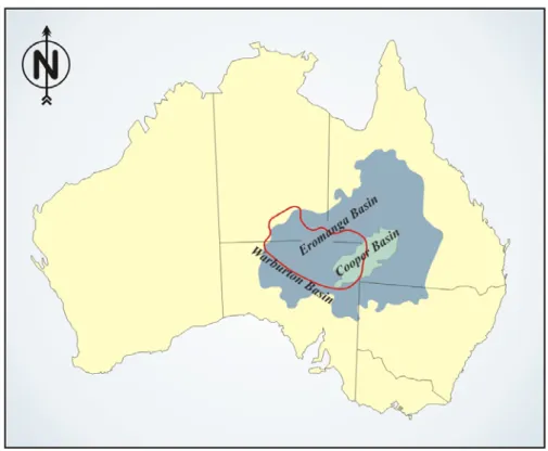
Figure 1 Location of the Cooper, Eromanga and Warburton Basins on the Australian continent.
Figure 2 Structural features of the western Cooper Basin, highlighting the location of the study area.
Chapter 2
Figure 3 Palaeogeographic setting of the Eromanga Basin during the Middle Jurassic.
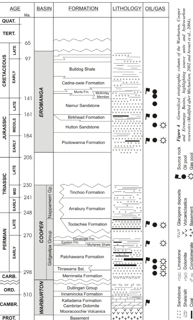
Figure 4 Generalized stratigraphic column of the Warburton, Cooper and Eromanga Basin sedimentary sequence.
Figure 5 NE-SW trending cross section through the southern Gidgealpa Dome, levelled on various horizons.
Chapter 3
Figure 6 Generalized subsidence chart of the Cooper and Eromanga Basins.
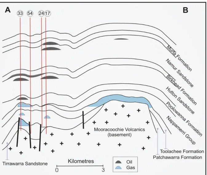
Figure 7 Schematic North-South trending cross section through the Gidgealpa Ridge, showing oil and gas accumulations.
Figure 8 Location of liquid and gaseous petroleum accumulations in the Gidgealpa Ridge.
Chapter 4
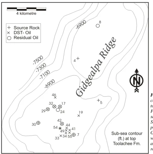
Figure 9 Sub sea contour map of the top Toolachee Formation highlighting well locations and corresponding sample types.
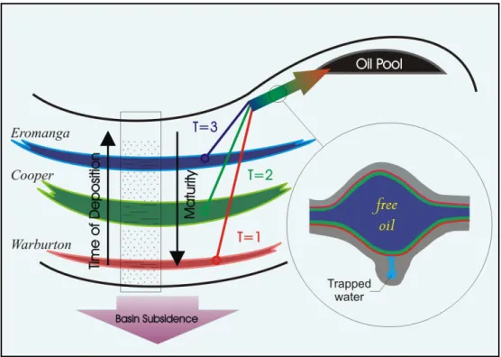
Figure 10 Schematic principle of pore-filling by multiple oil charges in the Warburton, Cooper and Eromanga Basins.
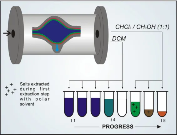
Figure 11 Simplified principle of sequential flow trough extraction.
Figure 12 Relative solubility of n-carbazole, 9-methylcarbazole, 9-phenylcarbazole and fluoren-9-one in four different organic solvents.
Figure 13 Principle of Iatroscan thin layer chromatography-flame ionizing detection (TLC-FID).
Figure 14 Principle of compound class separation by solid phase extraction (SPE).
LIST OF FIGURES
Chapter 5
Figure 15 Typical gas chromatograms of Cooper and Eromanga Basin oils.
Figure 16 Diagram reflecting the distribution of acyclic isoprenoids and paraffins in oils and source rock extracts.
Figure 17 Gas chromatographic elution order of hopane isomers and picture of the hopane carbon skeleton.
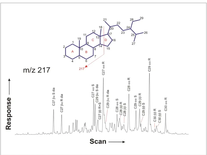
Figure 18 Gas chromatographic elution order of sterane isomers and picture of the sterane carbon skeleton.
Figure 19 Diagram of homohopane distribution, reflecting the depositional redox state of source rocks.
Figure 20 Distribution of C27, C28 and C29 steranes in source rock extracts and oils, shown in sterane ternary diagrams and a plot of C27/C29 sterane vs. Pr/Ph.
Chapter 6
Figure 21 Elution order of, and mass to charge ratio of fragments produced by carbazole isomers during GC-MS analysis.
Figure 22 Relationship between thermal maturity and alkylcarbazole concentrations in source rock extracts.
Figure 23 Relationship between maturity and benzocarbazole concentrations, and between maturity and the benzocarbazole a/(a+c) ratio in source rock extracts.
Figure 24 Relationship between ratios of alkylcarbazoles and thermal maturity in source rock extracts and DST oils.
Figure 25 Ternary diagrams showing the relative distribution of 1-, 2-+3- and 4-methylcarbazole in source rock extracts, DST oils and residual oils.
Figure 26 Ternary diagrams showing the relative distribution of 2-, 3- and 4-methylcarbazole in source rock extracts, DST oils and residual oils.
Figure 27 Relationship between ratios of alkylated carbazoles and the facies dependent Pr/Ph ratio.
Figure 28 Plot of 1-/9-methylphenanthrene vs. 3-/2-methylcarbazole, reflecting mixing processes between Cooper-, Eromanga- and Warburton-derived oils.
Figure 29 Plot of 1-/9-methylphenanthrene vs. 1,8-dimethylcarbazole/(1,8-dmc+1-ethylcarbazole) showing the ratios’ potential to discriminate between Permian and Jurassic oils.
Figure 30 Plot of 1-/9-methylphenanthrene vs. 1,7-/1,6-dimethylcarbazole, showing the potential of 1,7- /1,6-dmc to distinguish between Warburton Basin influenced oils and the remainder samples.
Figure 31 Plot of 1,8-dmc/(1,8-dmc+1-ec) vs. 2-/(2-+3-)methylcarbazole indicating three zones of increased Warburton Basin affinity for residual oils.
Figure 32 Typical methyl- and dimethylcarbazole mass chromatograms of pre-Permian, Permian and Jurassic samples.
Figure 33 Plots showing that the benzocarbazole a/(a+c)ratio in oils is neither dependent on maturity nor on facies.
Figure 34 Benzocarbazole concentrations in oils decrease with decreasing benzocarbazole a/(a+c) ratio, indicating secondary migration fractionation processes.
Figure 35 Fractionation behaviour of 1-/(1-+4-) methylcarbazole, benzocarbazole b/(a+b+c) ratio and C3/C2 carbazole during secondary migration.
Figure 36 Relationship between shielded vs. exposed carbazole isomers and C3/C2 carbazole ratios, indicating fractionation processes.
Figure 37 Series of ternary plots showing carbazole isomeric and carbazole compound class fractionation during primary and secondary migration.
LIST OF FIGURES
Chapter 7
Figure 38 Phenanthrene and methylphenanthrene mass chromatogram and carbon skeleton.
Figure 39 Structure of Araucariacaean biomarkers.
Figure 40 Example of an Araucariacaean mixing plot, featuring endmember areas and mixing ratios.
Figure 41 Example of a sequential extraction chart, indicating symbols and colour coding that will be kept throughout the chapter.
Figure 42 Distribution of oil pools in the southern Gidgealpa dome, featuring lateral maturity variations.
Figure 43 Isoreflectance map of the Birkhead Formation source rock.
Figure 44 Mixing plot of samples from the Namur Sandstone.
Figure 45 Sequential extraction chart of a Namur sandstone core from well 24.
Figure 46 Mixing plot of samples from the Birkhead Formation.
Figure 47 Sequential extraction chart of a Birkhead Fm. core from well 30.
Figure 48 Mixing plot of samples from the Hutton Sandstone, part I.
Figure 49 Mixing plot of samples from the Hutton Sandstone, part II.
Figure 50 Sequential extraction chart of a Hutton sandstone core from well 17 (hanging wall part).
Figure 51 Sequential extraction chart of a Hutton sandstone core from well 17 (footwall part).
Figure 52 Mixing plot of samples from the Poolowanna Formation.
Figure 53 Mixing plot of samples from the Toolachee Formation.
Figure 54 Sequential extraction chart of a Toolachee Fm. core from well 7.
Figure 55 Sequential extraction chart of a Toolachee Fm. core from well 8.
Figure 56 Mixing plot of samples from the Patchawarra Formation.
Figure 57 Selected GC traces from the southern Gidgealpa dome.
Figure 58 Comparison of maturity and migration distance of Permian and Jurassic oils.
Figure 59 Model for the filling history of the Hutton-Birkhead-Namur system.
Figure 60 Reconstructed charging history of Permian oils in the Gidgealpa area.
LIST OF TABLES
List of Tables
Chapter 4
Table 1 List of samples that were analysed and evaluated in this study.
Table 2 Comparison of the extraction efficiency of Sequential Flow Through Extraction (SFTE) versus Accelerated Solvent Extraction (ASE).
Chapter 6
Table 3 Summarised overview of literature data on carbazoles.
Table 4 List of samples that have received a pre-Permian input, as suggested by three discrete carbazole parameters.
Chapter 7
Table 5 Pattern of consistently varying migration distance in residual oils that contain a pre-Permian component, as indicated by the benzocarbazole a/(a+c) ratio.
DECLARATION
Declaration
Herewith I declare that to the best of my knowledge and belief, this work contains no material which has been accepted for the award of any other degree or diploma in any university or other tertiary institution, nor does it contain any material previously published or written by another person, except where due reference has been made in the text.
Christian Hallmann December 23rd, 2004
ACKNOWLEDGEMENTS
Acknowledgements
I thank Dr. Lorenz Schwark, who supervised this thesis, for his constructive support. During many discussions I gained extensive insight into various areas of organic geochemistry, and this thesis benefited from his knowledge.
Dr. Khaled Arouri first brought me in contact with the petroleum geology of the Cooper and Eromanga Basins. I thank him for useful discussions and gratefully acknowledge access to his data.
Prof. David McKirdy is thanked for his help in reviewing two abstracts and for useful comments on this study.
Guido Wiesenberg is thanked for reviewing a part of the manuscript.
Much of the work that was performed during the course of this study would not have been possible without the help of our laboratory staff. In particular I would like to thank Hanna Cieczinski, Bianca Stapper and Yassin Hardi.
Last but definitely not least I thank my family and Lisa Luhrenberg for their support, motivation and understanding.
ABSTRACT
Abstract
The oil play of the Permo-Carboniferous Cooper and Jurassic-Cretaceous Eromanga Basins in South Australia is complicated to unravel due to the presence of multiple source rocks that bear similar geochemical characteristics and has consequently been subject to intense debate.
The underlying Warburton Basin, although initially regarded an exploration target, subsequently has never been seriously considered to having participated in the oil play. The Cooper/Eromanga couplet is Australia’s largest onshore petroleum province and still bears potential for undiscovered commodities, making a profound understanding of origin and migration of petroleum a prerequisite for efficient future exploration.
Being a typical example of structurally trapped oils in stacked fluvial sandstone reservoirs, the Gidgealpa Ridge was chosen as subject for this study. A suite of 13 sandstone cores, 11 source rocks and 24 drill stem test (DST) oils were processed at the University of Cologne by extraction, sequential extraction of sandstone cores to yield residual oils, preparative liquid chromatography and solid phase extraction to yield fractions of saturated hydrocarbons, aromatic hydrocarbons, maltene resins and a carbazole enriched fractions. While biomarker analyses on saturates and aromatics were performed by Dr. Khaled Arouri at the University of Adelaide, molecular characterisation of carbazoles and bulk geochemical characterisation was also done at the University of Cologne.
Sequentially extracted residual oils are particularly useful because they allow a temporal resolution of petroleum reservoir filling histories. While hydrocarbon compositions are quickly equilibrated over a few tens of metres in oil columns, there is substantial evidence that the same is not true for polar species such as e.g. carbazoles and for lateral variations in hydrocarbon composition. Carbazoles were initially regarded as molecular markers indicating relative migration distances. However, counterevidence soon appeared, showing the dependency of carbazole distributions on other factors.
The results of this study show that, while the distribution of benzocarbazoles seems to depend only on fractionation processes during primary and secondary migration, alkylated carbazole distribution patterns are governed by source rock facies. This new finding allowed the recognition of a Warburton Basin contribution in certain residual oil fractions, yielding the first conclusive evidence that Warburton Basin rocks bear a source potential and have actively participated in the oil play of the Cooper and Eromanga Basins.
ABSTRACT
The application of carbazole facies parameters, benzocarbazole migration parameters and aromatic maturity data on oils and residual oils from the Gidgealpa Field has allowed the reconstruction of its charging history. Generally, Cooper Basin oils exhibit large maturity variations but a uniformly short migration distance, indicating their origin from a nearby deep trough (eastern source kitchen). Eromanga Basin oils are characterized by similarly low maturity values but highly varying migration distances, suggesting that they were sourced by an extensive and shallow source kitchen. More precise consideration of the carbazole distribution in Eromanga Basin oils shows that the Gidgealpa Field has received two discrete Birkhead charges: a Late Cretaceous pulse from an eastern source kitchen, which migrated a short distance, and became locally displaced by a Tertiary charge from a western source kitchen, which had to migrate further before reaching the Gidgealpa Field.
Residual oil fractions from the sandy intervals of the Toolachee and Patchawarra Formations indicate that while the former is a source for Cooper Basin Family 2 oils, the latter can unambiguously be tied to the production of Cooper Basin Family 1 oils. After petroleum generation in the Patchawarra Formation, this petroleum was probably retained by the coaly Patchawarra source rock, and underwent further maturation before it was expelled as condensate-like light oil in gaseous solution.
The analysis of sequentially extracted residual oils promises to become a powerful tool in reservoir geochemical studies by adding a temporal resolution to otherwise time-integrated samples, thereby allowing a relatively precise reconstruction of an oil field’s charging history. The finding of facies dependent markers in the polar fraction of oils is a constructive motivation for further research into the facies and maturity dependency of NSO compounds.
As many residual oils are characterized by minimum extracts yields and a high percentage of NSO compounds, conventional biomarker analyses are complicated and polar markers are necessary for a more precise evaluation.
ABSTRACT
Zusammenfassung
Die Rekonstruktion des oil play im Permo-Karbonischen Cooper und Jurassisch- Kretazischen Eromanga Becken in Süd Australien wird kompliziert durch die Anwesenheit mehrerer Erdölmuttergesteine, welche durch sehr ähnliche geochemische Charakteristika gekennzeichnet sind, und hat daher zu intensiven Debatten geführt. Während das unterlagernde Warburton Becken anfänglich ein Explorationsziel darstellte, wurde nachfolgend niemals ernsthaft an seine Teilnahme im oil play geglaubt. Das Cooper/Eromanga Becken ist Australiens größte Inlands-Erdölprovinz und enthält immer noch potentiell unentdeckte Erdölreserven, wodurch ein tiefgehendes Verständnis über den Ursprung und die Migration von Ölen eine Notwendigkeit für effektive zukünftige Explorationsaktivitäten darstellt.
Als ein typisches Beispiel von Ölen, welche in fluviatilen Sandstein Reservoiren struktureller Fallen gespeichert sind, wurde der Gidgealpa Rücken als Thema dieser Arbeit gewählt. Eine Serie von 13 Sandstein-Kernen, 11 Muttergesteinsproben und 24 drill stem test (DST) Ölen wurde mittels Extraktion, sequentieller Extraktion von Sandstein-Kernen, präparativer Flüssigchromatographie und Festphasenextraktion aufgearbeitet, um Fraktionen von gesättigten Kohlenwasserstoffen, aromatischen Kohlewasserstoffen, NSO Komponenten der Malten-Fraktion, und eine an Carbazolen angereicherte Fraktion zu erzeugen. Während Biomarker Analysen an aliphatischen und aromatischen Kohlenwasserstoffen von Dr. Khaled Arouri an der Universität zu Adelaide durchgeführt wurden, fand die molekulare Charakterisierung von Carbazolen sowie die Feststellung der relativen Anteile der ebengenannten Stoffklassen an der Universität zu Köln statt.
Sequentiell extrahierte Residualöle sind besonders nützlich weil sie eine zeitliche Auflösung der Füllungsgeschichte von Erdölreservoiren zulassen. Während sich Variationen in der Kohlenwasserstoffzusammensetzung einer Ölsäule rapide über einige zehn Meter an einander angleichen, gibt es zuverlässige Hinweise, dass dieses nicht für polare Stoffklassen, wie zum Beispiel Carbazole, und für laterale Kohlenwasserstoffvariationen gilt. Carbazole wurden anfänglich als molekulare Marker für relative Migrationsdistanzen betrachtet. Bald darauf erschienen jedoch Gegenbeweise, welche die Abhängigkeit der Carbazolverteilung von anderen Parametern zeigten.
ABSTRACT
Die Ergebnisse dieser Studie zeigen, dass, während die Verteilung von Benzocarbazolen nur von Fraktionierungsprozessen während primärer und sekundärer Ölmigration abhängt, das Verteilungsmuster von alkylierten Carbazolen von der Muttergesteinsfazies gesteuert wird.
Diese neue Erkenntnis führte zu der Entdeckung eines Ölbeitrags des Warburton Beckens zu bestimmten Residualölfraktionen, und liefert den ersten eindeutigen Beweis für das Erdölpotential des Warburton Beckens und seiner Teilnahme an dem oil play der Cooper/Eromanga Becken.
Die Anwendung von Carbazol-Faziesparametern, Benzocarbazol-Migrationsparametern Reifedaten an Ölen und Residualölen aus dem Gidgealpa Ölfeld erlaubte die Rekonstruktion seiner Füllungsgeschichte. Cooper Becken Öle weisen in der Regel hohe Reifeunterschiede aber eine einheitlich kurze Migrationsdistanz auf. Dies deutet auf ihren Ursprung aus einem nahen, tiefen Trog (östliche Muttergesteinsregion). Öle des Eromanga Becken charakterisieren sich durch ähnlich niedrige Reifewerte aber stark variierende Migrationsdistanzen, welches auf ihren Ursprung aus einer breiten und flachen Muttergesteinsregion hinweist. Eine genauere Auswertung der Carbazol-Verteilungsmuster zeigt, dass das Gidgealpa Ölfeld zwei separate Ölpulse aus der Birkhead Formation empfangen hat: einen spätkretazischen Puls, welcher eine kurze Distanz wanderte, und durch einen zweiten, tertiären Puls aus der westlichen Muttergesteinsküche verdrängt wurde.
Residualöl-Fraktionen aus sandigen Intervallen der Toolachee und Patchawarra Formation zeigen, dass während die Toolachee Formation eine Quelle für Cooper Becken ’Family 2’- Ölen darstellt, ‚Family 1’-Öle definitiv mit der Patchawarra Formation in Verbindung gebracht werden können. Nachdem die Patchawarra Formation Öle generiert hatte, wurden diese von dem kohlehaltigen Patchawarra Muttergestein zurückgehalten, und erfuhren weitere Reifung bevor sie als Kondensate ausgetrieben wurden.
Die Analyse von sequentiell extrahierten Residualölen ist eine erfolgversprechende Technik in reservoir-geochemischen Studien weil sie eine zeitliche Auflösung von ansonsten kumulativen Proben erlaubt. Auf diese Weise ist es möglich, die Füllungsgeschichte eines Ölfeldes relativ präzise zu rekonstruieren. Die Entdeckung von faziesabhängigen Markern in der polaren Fraktion von Ölen stellt eine konstruktive Motivation dar für weitere Untersuchungen zu der Fazies- und Reifeabhängigkeit von NSO-Komponenten. Da viele Residualöle durch minimale Extraktausbeuten und einem hohen Gehalt an NSO- Komponenten gekennzeichnet sind, ist die Analyse von konventionellen Biomarkern kompliziert und „polare Marker“ sind notwendig für genauere Aussagen.
CHAPTER ONE ___________________________________________
Introduction
The oil play of the Permo-Carboniferous Cooper and Jurassic-Cretaceous Eromanga Basins (Fig. 1) in Australia is complicated to unravel due to the fact that most oil pools were sourced by a multitude of source rocks that bear similar geochemical characteristics. Source rocks vary in age but are similar in organic facies, making it difficult to distinguish between them.
Furthermore, they are only accessible in elevated ridges and consequently little is known about their characteristics in the deep troughs that form the source kitchens.
Figure 1 The Jurassic-Cretaceous Eromanga Basin is underlain by the Permo- Triassic Cooper Basin. This couplet forms the largest onshore petroleum province in Australia. The partially marine Warburton Basin, which is of Palaeozoic age, underlies the Cooper/Eromanga Basins. Its source potential is currently subject to intense speculation but has been conclusively proven in this study.
INTRODUCTION
The Cooper/Eromanga Basins are underlain by the partially marine sequence of the Palaeozoic Warburton Basin, whose source potential is subject to controversy (Harvey and Hibburt, 1999; Boucher, oral communication) but has been proven in this study.
To increase the comprehension of origin, migration and mixing processes of oils in the Cooper and Eromanga Basins, an investigation named “Conditions and effects of hydrocarbon fluid flow in the subsurface of the Cooper-/Eromanga Basins” was initiated by the University of Adelaide, PIRSA and Santos Ltd., in which the University of Cologne participates as a research partner.
The petroleum-hosting stacked reservoirs of the Gidgealpa Ridge are a typical example of Cooper/Eromanga Basin petroleum accumulations. For this reason, the Gidgealpa Ridge area was chosen as a subject of this study. The obtained results may be transferable to other fields in the Cooper/Eromanga Basins that are characterised by a similar structural setting.
1.1 Scope of this thesis
Aim of this study is to reconstruct the origin and migration history of oils in the Gidgealpa Field by evaluation of the distribution of polar organic nitrogen compounds in source rock samples, DST oils and residual oils.
Aliphatic and aromatic biomarker data that has been made available by Dr. Khaled Arouri from the University of Adelaide was interpreted to determine the depositional environment of source rocks and explain the distribution of DST oils. Upon this backbone, the evaluation of carbazole geomarker distributions was based. Carbazoles were found in the polar fraction of drill stem test (DST) oils, source rock extracts and residual oils. In exception of aliphatic and aromatic biomarker analysis, all analyses were performed during the course of this study at the University of Cologne. These included gross composition analysis by thin layer chromatography – flame ionization detector (TLC-FID), solid phase extraction (SPE) of the maltene resins to obtain a purified carbazole fraction, and gas chromatography-mass spectrometry (GC-MS) of the latter.
It is anticipated that the results of this thesis will enhance our understanding of the oil play in the Cooper and Eromanga Basins and possibly reduce future exploration risk, as well as to improve understanding of the nature of carbazoles and their behaviour in the geosphere. As carbazoles still form a very speculative chapter of molecular organic geochemistry, the results of this thesis will be another piece, contributing to the big puzzle.
INTRODUCTION
1.2 Study area
The Gidgealpa Field is located towards the southern end of the Gidgealpa-Merrimelia- Innamincka (GMI) Ridge (Fig. 2) and can be treated as a typical example of oilfields in stacked reservoirs of the Cooper/Eromanga basins.
Being one of the oldest hydrocarbon discoveries, a wide range of data is available on this area (e.g.
Boreham and Summons, 1999; Boult et al., 1997).
The Gidgealpa Ridge consists of a metamorphic basement ridge that is onlapped by sedimentary sequences from the Permo-Carboniferous
Cooper and the Jurassic- Cretaceous Eromanga Basins. High thicknesses of these sediments accumulated in three adjacent troughs, where they are underlain by the partially marine sequence of the Warburton Basin.
Figure 2 The study area is situated towards the south-western end of the GMI Ridge and highlighted by the red frame. The two hydrocarbon accumulations that are depicted by the grey colour correspond to those of the southern and the northern Gidgealpa domes (modified after Alexander and Sansome, 1996).
The Gidgealpa Field is a northeast to southwest trending asymmetric anticline on top of the Hutton Sandstone. It comprises a northern and a southern dome that are separated by a shallow saddle structure. While the northern dome mainly hosts gases and condensates that are reservoired within Permian fluvio-glacigenic sandstones, the southern dome contains oils in stacked fluviatile sandstone reservoirs of Jurassic-Cretaceous age.
INTRODUCTION
1.3 History of petroleum exploration
The Cooper/Eromanga hydrocarbon province is Australia’s largest onshore petroleum production and exploration region, currently producing approximately 3 x 10⁹ m3 of gas, 0.4 x 10⁶ m3 of condensate and 0.6 x 10⁶ m3 of oil per annum (based on values from 1997; Harvey and Hibburt, 1997). Exploration has been mainly undertaken by the Delhi-Santos Ltd (South Australia and Northern Territories Oil Search) consortium since the 1950s. The discovery of the first commercial gas reserve in the Toolachee Formation at the Gidgealpa-2 well (title page) in 1963 (Michaelsen, 2002) was followed by the first oil discovery in the Tirrawarra Formation of the Tirrawarra Field seven years later. The Gidgealpa gas field was first brought on line in 1969 (McIntyre et al., 1997) and new near-field exploration and appraisal wells are still being drilled, e.g. Gidgealpa 58, which was completed in March 2004.
Although the production of mentioned commodities is declining since 1990, remaining proven reserves in the Cooper and Eromanga Basins are estimated on 5.5 x 10⁶ m3 oil and 100 x 109 m3 gases. Furthermore, the Cooper and Eromanga Basins bear a potential for undiscovered reserves, which are estimated (50% probability) by PIRSA at 5.4 x 10⁶ m3 of recoverable oil and 56 x 109 m3 of sales gas (Michaelsen, 2002).
Following these introducing words, chapter two and three elucidate the structural setting of the Cooper/Eromanga Basins and the Gidgealpa area, their sedimentary record and position in a petroleum geological context. An overview of the methods that were used to obtain results during this study is given in chapter four.
Results are discussed in chapter five, six and seven. Chapter five gives insight to the sources of oils and the facies of source rocks by evaluation of aliphatic biomarker data and the distribution of n-alkanes. Chapter six discusses the distribution of carbazoles in oils and source rock bitumens from the study area. In chapter seven, the results from carbazole analyses are combined with aromatic biomarker data to reconstruct the charging history of oil pools in the Gidgealpa Ridge by using a reservoir geochemical approach.
A summary of conclusions that were drawn from the obtained results is presented in chapter eight.
CHAPTER TWO ___________________________________________
Regional Geology
2.1 Geological evolution of Australia
Australia’s Archaic cratons mainly comprise metamorphic series of felsic and mafic rocks. A large amount of sediments and basic volcanics were deposited during the Proterozoic. These sediments of the Nullagineum, Carpentarium and Adelaidean mainly occur in the larger basins and have been little influenced by metamorphosis.
After the Late Proterozoic break-up of Rodinia, Gondwana grew continuously during the Proterozoic and Palaeozoic due to accretional processes on its pacific side, which held on until the Triassic. In the active fault zone and on stable shelves, sediments that belong to the Pre-Hercynian Megasequence started accumulating in basins, one of which was the Warburton Basin. A peri-equatorial position of the Australian continent allowed the deposition of limestones under shallow-marine conditions. Sedimentation continued until the Early Carboniferous when the super-continent Pangaea started to form and the Hercynian Tectogenesis, locally termed the Alice Springs Orogeny, caused the deformation of accumulated deposits (Wopfner, 1997).
While Pangaea drifted southward, the southern parts of former Gondwana straddled the South Pole and became covered by ice sheets as the Permo-Carboniferous glaciation, which is thought to having been tectonically induced, heralded the start of the second stratigraphic megasequence, the Pangaea Megasequence. Due to the stabilisation of the Tasman Geosyncline in the East and the development of a taphrogenic system in the West, a number of intracratonic basins evolved that bear document of the glaciation by tillite deposits and glacial marks on the bedrock. On the eastern Australian margin, a compressive molasse basin, the Sydney Basin, evolved. In the West, a group of extensional basins that can be related to extensional dynamics in the newly established Tethys realm developed. Translational
REGIONAL GEOLOGY
movements in central Australia gave rise to a number of epicratonic basins that lack of any marine influence and include the Cooper Basin (Wopfner, 1997). A Sakhmarian transgression, caused by a postglacial eustatic sea level rise, allowed vast fluviodeltaic swamps to emerge, which are responsible for the large worldwide coal deposits of the Carboniferous and Permian. This peat-producing phase was set to an end during the Middle Triassic by Cimmerian tectonic activity, which caused the opening of a rift system that would later separate Australia from the rest of Gondwana.
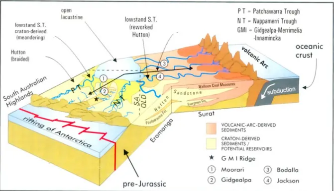
The Post-Cimmerian megasequence runs from Late Triassic to Late Cretaceous. During the Jurassic, the North-South-trending rift, offshore what is currently Australia’s South coast, proceeded further South (corresponding to a present-day eastward movement along the Australian South coast), opening up the Otway Basin. Further inland, the Eromanga and Murray Basins started to subside (Wopfner, 1997). Fluvial sedimentation dominated the Jurassic and allowed the deposition of extensive sandstone accumulations that bear good reservoir qualities for both, hydrocarbons and water. Therefore the Eromanga Basin is also named the Great Artesian Basin. A newly established subduction zone along the eastern Australian margin led to active volcanism and consequently to a varying input of volcanic arc derived (VAD) sediments into the central basins (Fig. 3; Boult et al., 1998).
During the Neocomian, almost the complete continent became flooded by a marine ingression that was caused by the Cretaceous global sea level highstand, and led to the deposition of siliciclastics sediments and marine shales (Alexander and Sansome, 1996). While the basins in the south-eastern part of Australia were not affected, and lacustrine conditions were preserved until Middle Cretaceous, the Eromanga Basin saw a change to marine sedimentation. Meanwhile, the rift between Australia and Antarctica had reached the ocean- spreading phase. The uplift of the rift shoulders caused a tilt of the Australian continent and marine waters in the Eromanga Basin consequently regressed northward.
After the detachment from Antarctica from Australia, only few pericratonic basins (e.g.
Gipsland Basin) remained and started or continued to subside during the Tertiary. Their sediments belong to the Post-Laramic Megasequence that started during the Palaeogene.
2.2 Tectonic setting
Wopfner (1997) subdivided the Australian continent in four geotectonic units, based on the pattern of gravitational anomalies. These are: the Southwestern Craton, the North Australian Shield, the Tasman Geosyncline and the Transaustralian Faultzone; the latter is also known as the Submobile Basinzone. The Warburton, Cooper and Eromanga Basins are located in the Transaustralian Faultzone, which came into existence during the Middle Proterozoic.
REGIONAL GEOLOGY
Figure 3 Palaeogeographic setting of the Eromanga Basin during the upper Middle Jurassic, showing the sedimentary change of provenance from craton-derived sandstones to volcanic arc derived (VAD) sediments (From Boult et al., 1998).
2.2.1 Warburton Basin
Wopfner (1972, cf. Wopfner, 1997) assigned Early Palaeozoic series that underlie the Permian deposits of the Cooper and Pedirka Basins to the Warburton Basin (Fig. 1 and 4). Warburton Basin sediments include thick Cambrian carbonate sequences, late-Adelaidean to early Cambrian Rhyolites and Ignimbrites, Ordovician Shales and Devonian Redbeds. The bedrock consists of Proterozoic phyllite, mica-slate and gneiss. During the Kanimbla orogeny, the Warburton Basin was intruded by tonalites (Gatehouse, 1986, cf. Michaelsen, 2002). In a sequence stratigraphic context, the Warburton Basin deposits can be assigned to the pre- Hercynian megacycle, which was dominated by marine sedimentation in the Transaustralian Fault Zone and on stable shelf regions north and south of it. The Warburton Basin has a complex tectonic history that is largely speculative due to a lack of reliable data and detailed study.
While the Warburton Basin sedimentary sequence was only mildly influenced by the Late Cambrian Delamerian orogen, early work on the Gidgealpa area suggests thrust-fault repeated sections, indicating a convergent tectonic regime (Sun, 1999 and ref. therein) that was triggered by the Carboniferous Alice Springs orogeny.
REGIONAL GEOLOGY
Figure 4 Generalized stratigraphic column of the Warburton, Cooper and Eromanga Basins, highlighting source unitsand hydrocarbon reservoirs (Modified after Michaelsen, 2002 and Arouri et al., 2004).
REGIONAL GEOLOGY
2.2.2 Cooper Basin
The Carboniferous to Triassic Cooper Basin is one of a number of remnant Late Carboniferous-Early Permian depocentres in the interior of Gondwana (Gravestock and Jensen-Schmidt, 1998). In contrast to other Mesozoic basins, the Cooper Basin developed as an intra-cratonic depocentre and lacks of any marine influence. Accumulation of sediments commenced after the Devonian-Mid Carboniferous Alice Springs orogeny, which is counted to the Hercynian tectogenetic cycle, and ceased at the end of the Middle Triassic (Fig. 4) as a consequence of basin-wide compression (Michaelsen, 2002). This tectonic compression event resulted in folding and uplift, and led to a ridge and trough morphology. Three major depressions developed, the Patchawarra, Nappamerri and Tenappera Troughs, which are separated by structural ridges, the Gidgealpa-Merrimelia-Innamincka (GMI) Ridge, the Murteree Ridge and the Nappacoongee Ridge (Fig. 2). The linear ridge trends are followed by fault zones that extend from the Cooper into the overlying Eromanga Basin. Late Triassic uplift resulted in erosion of Permian and Triassic strata from ridge crests. Sprigg (1961, cf.
Alexander and Jensen-Schmidt, 1996) postulated that rejuvenation of existing pre-Permian faults and differential tectonics have controlled sedimentation on ridges by causing onlap onto the horst blocks. Michaelsen (2002) and sources therein however state that there is little if any argument for the reactivation of faults at intervals throughout the depositional history of the Cooper and Eromanga Basins.
2.2.3 Eromanga Basin
The Jurassic-Cretaceous Eromanga Basin is an epicratonic sag basin that formed as a consequence of crustal subsidence in the Early Jurassic (Alexander and Jensen-Schmidt, 1996). It entirely covers the Cooper Basin and most of the Warburton Basin. The main depocentres, in which high thicknesses of sediments accumulated during a period of tectonic quiescence, shifted westward from the Nappamerri and Patchawarra Troughs (Cooper area) to the Poolowanna Trough during its depositional history. These two depocentres are separated by the Birdsville Track Ridge, a major Northeast-Southwest trending structural feature. While the lower Eromanga Basin deposits are fluvial-terrestrial, younger strata have been influenced by a marine transgression (Fig. 4). Most regional and local faults of the Cooper Basin extend into the Eromanga sequence (Krieg, 1995, cf. Michaelsen, 2003).
REGIONAL GEOLOGY
2.2.4 Study area
The Gidgealpa field, a single four-way dip closed, draped anticline, is comprised of two culminations (North and South) that are separated by a relatively shallow saddle (Chen and Lonergan, 1991). It is located on the crest of the Gidgealpa-Merrimelia-Innamincka ridge (Fig. 2), an arcuate series of northeast-southwest trending en-echelon structures that form one of the three major Cooper Basin structural trends and separate the Nappamerri Trough to the East from the Patchawarra Trough to the west (Alexander and Sansome, 1996). Basement and near-basement faulting defines a number of fault blocks, which are interpreted to have moved relative to each other during the Early Permian and, in doing so, had a marked effect on deposition (McIntyre et al., 1989).
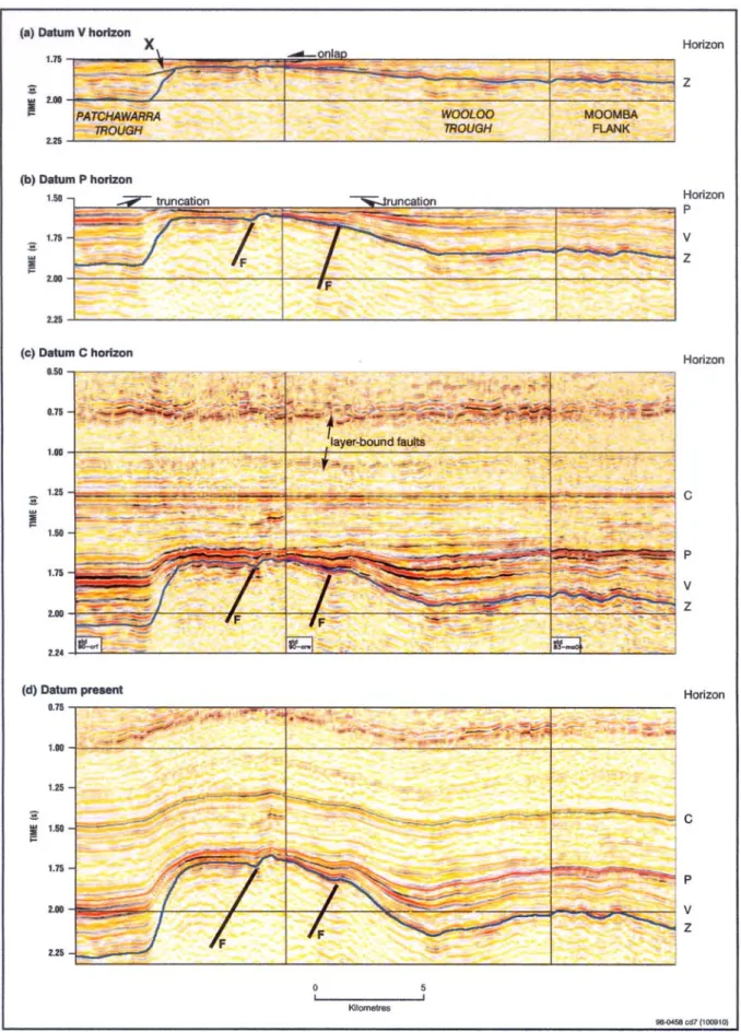
Figure 5 shows the evolution of the Gidgealpa Ridge and adjacent troughs in a schematic ESE-WNW trending seismic section. The first frame (Fig. 5a) is levelled on the V-horizon, which is the top of the Patchawarra Formation seismic horizon, and shows the asymmetric geometry of the uplifted basement that caused onlap of the V-Z package of sediments, in which the Z-horizon represents the base of the Cooper Basin. The asymmetry was caused by an overthrusting of the basement to the Northwest. The seismic P-horizon corresponds to the top of Permian coal. The second frame (Fig. 5b) shows faults (F) that originate from the beginning subsidence of the Wooloo and Nappamerri Troughs, which caused the tilting of fault blocks. The C-horizon levelled frame (Fig. 5c), in which the C-horizon corresponds to the top Cadna-owie Formation, shows the difference between the flat floored Patchawarra Trough and the subsiding Wooloo Trough. Layer bound faults in marine Cretaceous sediments are related to compaction and expulsion of pore fluids. The present day low- amplitude fold pattern (Fig. 5d) was caused by Tertiary East-West directed compression.
2.3 Sedimentary record
2.3.1 Warburton Basin units
-Mooracoochie Volcanics
The Mooracoochie Formation comprises acid to intermediate volcanics, tuff and agglomerates of ignimbrite (Taloola Ignimbrite Member). The massive volcanics are porphyritic trachytes, shattered and penetrated by dacitic lava.
REGIONAL GEOLOGY
Figure 5 A cross section through the Gidgealpa Ridge, levelled on the V, P and C horizons and the present datum surface, shows the evolution of the ridge and trough morphology and areas of sedimentation (from Gravestock and Jensen-Schmidt, 1998).
REGIONAL GEOLOGY
-Diamond Bog Dolomite
The early Middle Cambrian dolomitic limestones are characterised by a vuggy and moldic porosity that indicates a marine highstand deposit, altered by sub-aerial exposure.
-Kalladeina Formation
The Kalladeina Formation comprises clastic and carbonate shelf lithologies that were deposited in a shallow marine environment. The carbonates consist of an ooid grainstone that is partially dolomitised. The upper Kalladeina Formation represents a highstand system tract that can be subdivided into three parasequences: early highstand aggradation, middle highstand progradation and late highstand regression. The lower Kalladeina Formation is seismically characterized by several cycles of catch-up and keep-up carbonate systems.
The Dullingarie Group is the basinal equivalent to the shelfal Kalladeina Formation. It locally contains black graptolitic shales.
-Innamincka Formation
The Innamincka Formation is characterised by stacked shoaling-upward parasequences of deltaic siltstones and rippled glauconitic sandstone, which may indicate a shallow stable shelf under the influence of frequent sea-level fluctuations. The increase of siliciclastic components at the expense of carbonate suggests an approaching shoreline. The Pando Formation sandstones and Pondrinie Formation extrusive basalts are locally restricted members within the Innamincka Formation.
2.3.2 Cooper Basin units
Gidgealpa Group
The lower series of non-marine Cooper Basin deposits are characterised by termino-glacial clastics, overlain by detritic sediments that are characterized by low-sulphur coal measures and mainly occur within the Patchawarra, Epsilon and Toolachee Formations (Gravestock et al., 1998). The lateral extent, high thickness and low ash content of coals allow their comparison with high latitude blank mires. Diessel (1992, cf. Alexander, 1996) interpreted leaf cuticles within the coals as autumn leaf falls from Glossopterid fauna.
REGIONAL GEOLOGY
-Merrimelia Formation
Sediments of the Merrimelia Formation comprise a vast range of lithotypes that were created by rapid facies transitions in a glacial dominated environment. The formation covers a period from the Stephanian to the Asselian, during which its sediments have been deposited in troughs, onlapping topographic rises to the mid-flank regions of ridges throughout the Cooper Basin (Alexander, 1998).
Both, the Merrimelia Formation and the Tirrawarra Sandstone, form an integrated suite of sediments, deposited in terminoglacial and proglacial scenarios. During the maximum approach of the continental Merrimelia ice sheet, which started its growth during the Stephanian, the sediments of the Merrimelia Formation sensu strictu were deposited. As soon as a fluctuation of glacial influence occurred, triggered by the relative movement of the Australian subcontinent away from the Antarctic region, an interfingering sequence of Merrimelia type and Tirrawarra type sediments was deposited.
The lithology is solely controlled by the aquatic energy, which in turn depends on the distance from the glacial ice sheet. It ranges from poorly sorted, clast supported conglomerates, sandstones, and siltstones, which were deposited under high energetic conditions, to kettle hole deposits that exhibit rainout diamictites and dropstones.
The Merrimelia sandstones host a few minor hydrocarbon accumulations, which have been sourced down-dip from Cooper Basin source rocks (Michaelsen, 2002).
-Tirrawarra Sandstone
A local unconformity subdivides the Stephanian to Asselian Tirrawarra Sandstone into a lower part, belonging to the Merrimelia type facies, and an upper part, which is locally diachronous and intertongues with the Patchawarra Formation (Seggie, 1997, cf. Alexander, 1998). The upper section must although be distinguished from the ’Tirrawarra Sandstone-like’
facies of the Patchawarra Formation (Alexander et al., 1998).
During further retreat of the glaciers in southerly direction, meltwater streams that flew to the North carried glacigenic material and reworked unconsolidated Merrimelia sediments. The first two of four sedimentological associations (Williams et al., 1984), consist of longitudinal gravel bars with reworked Merrimelia and Warburton Basin material (1) and medium to coarse grained lithic sandstone with rare conglomerate, mudrock and coal bed (2) (Alexander, 1998). Low angle and planar cross bedded units are stacked, including coarsening up and fining up sequences. These two associations, of which the latter exhibits the better hydrocarbon-reservoir potential, belong to the Tirrawarra/Merrimelia facies. Associations three and four represent an evolution into a mixed load meandering fluvial system, consisting of stacked sandstone fining up sequences (3) and thick conglomerates with reworked Merrimelia clasts (4) that may have been sourced from adjacent palaeohighs (Alexander et al.,
REGIONAL GEOLOGY
1998). The Gidgealpa South field contains association 4 conglomerates, derived from the North Gidgealpa Palaeohigh (see also section on Patchawarra Formation).
Being the main oil reservoir in the Cooper Basin, the Tirrawarra Sandstone hosts approximately 80 % of all Cooper oils, which are located in the Tirrawarra Field (Michaelsen, 2002).
-Patchawarra Formation
Asselian to Artinskian Patchawarra deposits consist of fluvial, fine to medium grained sandstones, lacustrine siltstones and shales. In the Gidgealpa Field the basal Patchawarra layer is formed by a conglomerate of reworked Mooracoochie volcanics that have been eroded from the crest of the Gidgealpa Ridge. Coals, containing Type II to Type III kerogen, are widespread within these strata in the Patchawarra Trough, making it the main source kitchen for hydrocarbons in the Cooper Basin. Furthermore, the Patchawarra Formation serves as the most important gas-condensate reservoir in the Cooper Basin. Even though it is the thickest Permian unit, it has been eroded off heights such as e.g. the GMI-ridge.
The sedimentary environment has been interpreted as a highly sinuidal fluvial system, flowing northward (Stanmore and Johnstone, 1988) over a floodplain with peat swamps, lakes and gentle uplands (Stuart, 1976, cf. Alexander et al., 1998; Stanmore and Johnston, 1988) that feature point bars and crevasse splay deposits (Williams, 1995, cf. Alexander, 1998).
-Murteree Shale
During the Artinskian, a deep lake environment developed. This is documented by argillaceous, laminated shales that largely lack wave ripples and any evidence of turbiditic reworking. The fine-grained pyrite and muscovite containing Murteree Shale has been eroded of crestal areas.
The hydrocarbon potential is zero or very minor, at the most capable of producing negligible amounts of gas. It could, however, act as a seal in favourable conditions (Michaelsen, 2002).
-Epsilon Formation
Quartzose sandstones that were deposited in a fluviodeltaic and lacustrine shoreface setting toddled in dependency of regional trans- and regressions during the Artinskian to early Kungurian. Dispersed Type II kerogen coal seams do not contain enough organic material for the production of relevant amounts of hydrocarbons (Alexander, 1998; Michaelsen, 2002), but can contaminate passing hydrocarbon charges.
REGIONAL GEOLOGY
-Roseneath Shale
Conformably overlying the Epsilon Formation, the Roseneath Shale documents a return to lacustrine conditions. The depositional environment was similar to that of the Murteree Shale.
Silt- and mudstones with interbedded fine-grained sandstones contain load marks and slump folds, indicating mass flows and slope instability during its deposition in Kungurian times (Stuart, 1976, cf. Alexander et al., 1998).
-Daralingie Formation
Sedimentation of Kungurian to Ufimian Daralingie beds was restricted to the Cooper Basin area south of the GMI Ridge. During the regression of the ’Roseneath Lake’, deltaic systems developed, which allowed the deposited of sandstones, shales and minor amounts of coal during their progradation to the northeast. Williams (1995, cf. Alexander, 1998) interpreted the sediments as delta front bars, lake-margin beach and lake-margin shoreface deposits that pass on to a fluvial channel, backswamp and marsh environment.
-Toolachee Formation
The uppermost unit of the Gidgealpa Group is represented by fine to coarse grained, buff to white sandstones, dark siltstones and carbonaceous shales. Thin (<3m), laterally continuous coal seams occur and, adjacent to structural heights, a basal conglomerate layer that contains clasts of reworked Warburton Basin material was deposited. Glossopteris leaves that are preserved on bedding planes in laminated siltstones give insight to the prevailing flora.
Mackie et al. (1995, cf. Alexander, 1998) and Alexander (1998) interpreted the sedimentary structures to originate from ephemeral lakes and backswamps in the flood-basin. Sandstone packages document channels that were abandoned by chute and neck-cut-off and crevasse splays. The Toolachee Formation was divided into three sedimentary association by Mackie et al. (1995, cf. Alexander, 1998) and Williams (1995, cf. Alexander, 1998). The first association represents a fluvial system flowing to the North-East. Association two, being dominated by mudstones and coal seams, documents overbank flooding and flood-basin lakes. It is overlain by crevasse splay sandstones. In the Gidgealpa Field a third association exists, containing coarse-grained fining-upward packages, which Alexander et al. (1998) interpreted as high- sinuosity alluvial channels.
REGIONAL GEOLOGY
Nappamerri Group
Triassic sediments are developed in a redbed facies and reach maximum thicknesses in the Nappamerri and Patchawarra Troughs, where they onlap structural ridges. Of many stratigraphic arrangements, the Channon and Wood (1998) framework is adopted in this study. The Triassic coal gap makes these strata useless as source rocks but their high lateral extent turns them into useful regional seals.
-Arrabury Formation
Mudstones, siltstones and sandstones of the Tatarian to Anisian Arrabury Formation cover almost all of the Cooper Basin, including structural heights. It has although been eroded from the crest of the Murteree Ridge.
In contrast to the dark grey, organic rich siltstones and coals of the Toolachee Formation, the Arrabury Formation strata exhibit a drop in organic carbon content, a change in magnetic polarity and a major δ13Corg-excursion. Although they generally appear as redbed sediments, the deposition controversially took place during a rather humid palaeoclimate in a vegetated floodplain with ephemeral lakes. Symptoms of pedogenesis are present on exposed areas.
Northeast-Southwest trending channel belts in the Patchawarra and Nappamerri Troughs indicate the presence of low-sinuosity rivers that cut the floodplain. The Arrabury Formation bears witness of the beginning Triassic coal gap.
-Tinchoo Formation
In contrast to the Queensland-sector of the Cooper Basin, much of the Tinchoo Formation has been eroded in South Australia. These Anisian to Ladinian strata are restricted to the northeastern Patchawarra Trough and the northern area of the Cooper Basin (Channon and Wood, 1989). Sedimentary structures suggest a deposition in fluvial channels that differed across the flood basin between high and low-sinuosity fluvial facies.
-Cuddapan Formation
Remnants of the eroded Cuddapan Formation are restricted to the Patchawarra Trough in South Australia. These deposits strongly resemble the overlying Poolowanna Formation.
Sandstones, siltstones and coal interbeds were deposited during the Carnian and Norian in a high-sinuosity fluvial system with flood basin coal swamp development. The recovery of peat swamps, which reach high thicknesses in the time-equivalent Peera Peera Formation, (Simpson Basin) indicates the end of the Triassic coal gap.