SCIENTIFIC COMMITTEE
This paper is presented for consideration by CCAMLR and may contain unpublished data, analyses, and/or conclusions subject to change. Data in this paper shall not be cited or used for purposes other than the work of the CAMLR Commission, Scientific Committee or their subsidiary bodies without the permission of the originators and/or owners of the data.
Commission for the Conservation of Antarctic Marine Living Resources Commission pour la conservation de la faune et la flore marines de l’Antarctique Комиссия по cохранению морских живых pесурсов Антарктики Comisión para la Conservación de los Recursos Vivos Marinos Antárticos
SC-CAMLR-39/BG/13
21 September 2020 Original: English
Evaluation of the achievement of WSMPA conservation features and their target values for WSMPA Phase 1
K. Teschke, S. Hain, H. Pehlke, P. Brtnik, G. Griffith, A. Lowther and T. Brey
1 Evaluation of the achievement of WSMPA conservation features and their target values
for WSMPA Phase 1
Teschke, K., Hain, S., Pehlke, H., Brtnik, P., Griffith, G., Lowther, A. & Brey, T.
Background
At CCAMLR-38, the Delegation of the European Union and its Member States and Norway proposed that the Weddell Sea Marine Protected Area (WSMPA) should be adopted by CCAMLR in two phases:
WSMPA Phase 1 and WSMPA Phase 2 (CCAMLR-38/23). A proposal to establish WSMPA Phase 1 has been submitted to CCAMLR-38. At this point, we provide brief information on the achievement of the WSMPA conservation features and their conservation targets for WSMPA Phase 1.
Material & Methods
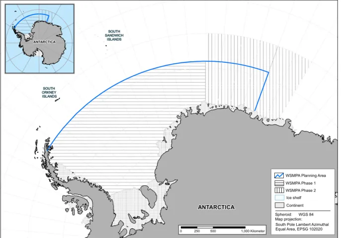
First, we carried out a visual inspection of all conservation features and their geographical location within the Weddell Sea region and identified those conservation features that are no longer part of the WSMPA Phase 1 Planning Area (see Fig. 1).
Figure 1 Overview of the WSMPA Phase 1 and WSMPA Phase 2 Planning Area. Area within the blue border:
original WSMPA Planning Area; cross-striped area: WSMPA Phase 1 Planning Area with eastern border at prime meridian; longitudinal striped area: WSMPA Phase 2 Planning Area (northern border: 60°S; eastern border: 30°E;
western border: prime meridian; cf. WG-EMM-2019/14). Please note: Borders of the planning areas do not resemble the boundaries of any proposed MPA.
ANTARCTICA
ANTARCTICA
SOUTH ORKNEY ISLANDS
SOUTH SANDWICH
ISLANDS
0 250 500 1,000Kilometer
70° S
Map projection:
South Pole Lambert Azimuthal Equal Area, EPSG 102020 Spheroid: WGS 84
WSMPA Phase 2 Ice shelf WSMPA Phase 1
Continent WSMPA Planning Area
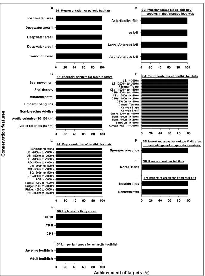
2 Second, we calculated the achievement of the medium conservation target values of each conservation feature for WSMPA Phase 1 (see Fig. 2) based on the following factors:
(a) Total area of each conservation feature in the WSMPA Phase 1 Planning Area, (b) Area that should be achieved according to the medium conservation target values, and (c) Area actually covered by each conservation feature within the WSMPA Phase 1 boundaries.
The medium conservation target values were derived from the 2nd WSMPA International Expert Workshop where the experts identified the lowest and highest target values for each conservation feature. The target values were given as a proportion of the area to be protected of the total distribution of the respective conservation feature (0% ≤ target value ≤ 100%). The medium conservation target values of each WSMPA conservation feature - derived from the lowest and highest conservation features - were presented, inter alia, at the meeting of the Scientific Committee in 2018 (SC-XXXVII/BG/15, see Appendix Table A4).
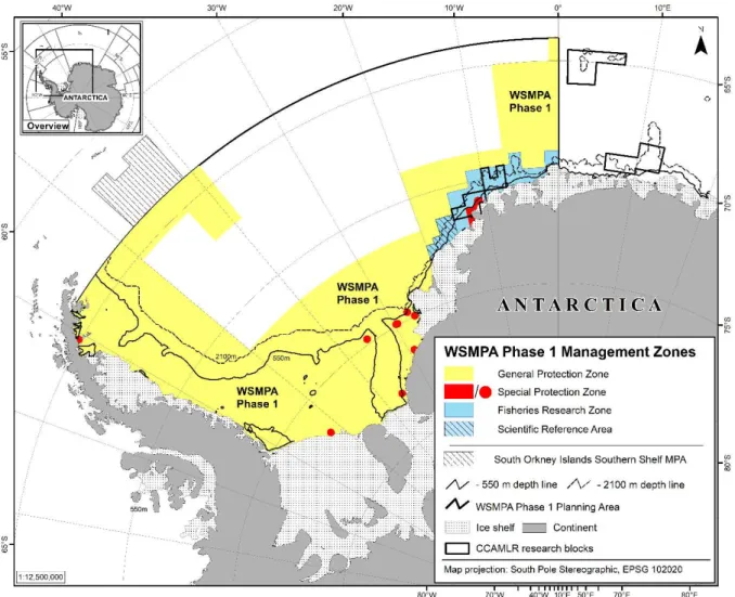
Figure 2.The WSMPA Phase 1, including the boundaries of the General Protection Zone yellow), the Special Protection Zone (red) and the Fisheries Research Zone (blue) with its scientific reference area (blue-hatched). The WSMPA Phase 1 Planning Area is shown with the black line. The boundaries of the General Protection Zone are also the boundaries of the WSMPA Phase 1.
3 Results
Visual inspection
The following environmental (bathymetric) conservation features (in total 21) are no longer within the WSMPA (Phase 1) Planning Area (see Figure A1 – A4):
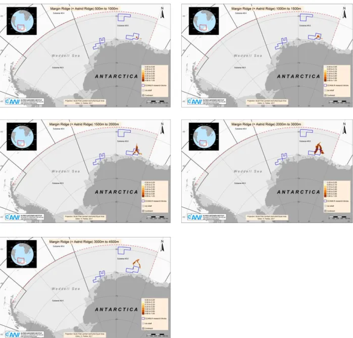
(a) Margin ridge (=Astrid Ridge) with all depth horizons (-500m to -4500m) (Fig. A1)
(b) Marginal plateau (-2000m to -4500m), plateau (-2000m to -4500m) and plateau slope (-2000m to -3000m) (Fig. A2)
(c) Seamount ridge (-1000m to -1500m and -3000m to -4500m) and seamount (-1000m to > - 4500m) (Fig. A3)
(d) Shelf, shelf deep (0 to -100m) and upper slope (0 to -200m and -3000m to -4500m) (Fig. A4)
The complete set of 75 standardised maps that show the spatial distribution of each environmental (bathymetric) and ecological conservation features in the wider Weddell Sea region is available through the CCAMLR e-group “Weddell Sea MPA”.
Achievement of conservation target values
Medium conservation target values were fully met within the WSMPA Phase 1 Planning Area (see Fig.
3). In addition, the remaining conservation features (i.e. 18 ecological and 36 environmental features) cover the WSMPA specific conservation objectives (S1 - S12) and thus meet the objectives of the WSMPA Phase 1 proposal.
Summary
The purpose of this document is to update and inform CCAMLR about conservation features that are no longer within the WSMPA Phase 1 Planning Area, such as Astrid Ridge and Maud Rise, with these features being considered in the further planning process of WSMPA Phase 2.
Of the original 75 conservation features, 54 now remain in the WSMPA Phase 1 Planning Area (i.e.
west of the prime meridian). The calculations show that the WSMPA Phase 1 boundaries are still appropriate to achieve the remaining 54 conservation features with their medium target values.
4
S1: Representation of pelagic habitats
0 20 40 60 80 100
Transition zone Deepwater area I Deepwater areaII Deepwater area III Ice covered area
0 20 40 60 80 100
Adélie colonies (50km) Adélie colonies (50-100km) Non-breeding Adélies Emperor penguins Antarctic petrel Seal density Seal movement
0 20 40 60 80 100
Adult Antarctic krill Larval Antarctic krill Ice krill Antartic silverfish
0 20 40 60 80 100
Abyssal Plain: > -3000mCSV: -1000m to -1500mBank: -500m to -1000mCSVy: -100m to -200mCSV: -500m to -1000mBank: -100m to -200mBank: -200m to -500mLS: -2000m to -3000mCSV: -200m to -500mBank: 0m to -100mCSV: 0m to -100mCoastal TerraneFilchner TroughCanyon Shelf Canyon SlopeLS: > -3000m
S4: Representation of benthic habitats S3: Essential habitats for top predators
S2: Important areas for pelagic key species in the Antarctic food web
0 20 40 60 80 100
Adult toothfish Juvenile toothfish Dummy CP I CP II CP III
S10: Important areas for Antarctic toothfish S8: High productivity areas
Achievement of targets (%)
A B
C D
E F
G
0 20 40 60 80 100
PS: -3000m to -4500m Ridge: -1500 to -2000m Ridge: -2000 to -3000m Ridge: -3000 to -4500m ROF: > -3000m SR: -2000m to -3000m SD: -200m to -500m SD: -500m to -1000m US: -200m to -500m US: -500m to -1000m US: -1000m to -1500m US: -1500m to -2000m US: -2000m to -3000m Echinoderm fauna
S4: Representation of benthic habitats
0 20 40 60 80 100
Demersal fish Nesting sites Dummy1 Norsel Bank Dummy2 Sponges presence
S5: Important areas for unique & diverse assemblages of suspension feeders
S7: Important areas for demersal fish S6: Rare and unique habitats
Conservation features
Figure 3 Achievement of conservation features or their medium target values (in %) for the WSMPA Phase 1 proposal. The features were arranged by their corresponding specific objective (S1 - S8, S10). Note: Specific conservation objectives S9 and S11-S12 are not shown. S9 is reflected in all the conservation features and not in a unique feature, and we wanted to avoid a repeated presentation of features. S11 and S12 defining research objectives that are not directly reflected by any of the conservation features.
Abbreviations: LS: Lower Slope, CSV: Cross Shelf Valley (D); US: Upper Slope, SD: Shelf Deep, SR: Seamount Ridge, ROF: Rugose Ocean Floor, PS: Plateau Slope; (E); and CP: Coastal Polynya (G).
5 References
CCAMLR-38/23 (2019): Proposal to establish a Marine Protected Area across the Weddell Sea region (Phase 1), Delegation of the European Union and its Member States and Norway, CAMLR Commission Meeting, Hobart, Australia, 21 October to 1 November 2019, 36 pp.
SC-CAMLR-XXXVII/BG/15 (2018): Scientific background document in support of the development of a CCAMLR MPA in the Weddell Sea (Antarctica) – Version 2018 – Reflection on the recommendations by WG-EMM-17 and SC-CAMLRXXXVI, Delegation of Germany, CCAMLR Scientific Committee Meeting, Hobart, Australia, 22 to 26 October 2018, 34 pp.
WG-EMM-2019/14 (2019): Report of the Workshop on data and modelling issues relevant to the planning of a potential Marine Protected Area (MPA) east of the zero meridian in the Weddell Sea (MAUD), Delegation of Norway, Meeting of the Working Group on Ecosystem Monitoring and Management, Concarneau, France, 24 June to 5 July 2019, 19 pp.
6 Annex
Figure A1 Margin ridge (=Astrid Ridge) with all depth horizons (-500m to -4500m) is located only east of the prime meridian and is exclusively situated in the WSMPA Phase 2 Planning Area.
7 Figure A2 Marginal plateau (-2000m to -4500m), plateau (-2000m to -4500m) and plateau slope (-2000m to -3000m) is located only east of the prime meridian and is exclusively situated in the WSMPA Phase 2 Planning Area.
8 Figure A3 Seamount ridge (-1000m to -1500m and -3000m to -4500m) and seamount (-1000m to >
- 4500m) is located only east of the prime meridian and is exclusively situated in the WSMPA Phase 2 Planning Area.
9 Figure A4 Shelf, shelf deep (0 to -100m) and upper slope (0 to -200m and -3000m to -4500m) is located only east of the prime meridian and is exclusively situated in the WSMPA Phase 2 Planning Area.