• Keine Ergebnisse gefunden

Ecological studies on the vegetation of a semi-arid desert following a climatic gradient (Richtersveld, South Africa)

N/A
N/A
Protected

Academic year: 2021

Aktie "Ecological studies on the vegetation of a semi-arid desert following a climatic gradient (Richtersveld, South Africa)"

Copied!
241
0
0

Wird geladen.... (Jetzt Volltext ansehen)

Volltext

(1)

Inaugural Dissertation

zur

Erlangung des Doktorgrades

der Mathematisch-Naturwissenschaftlichen Fakultät

der Universität zu Köln

following a climatic gradient (Richtersveld, South Africa)

vorgelegt von Stefanie Nußbaum

aus Köln

Köln 2003

(2)

Berichterstatter:

Prof. Dr. Michael Melkonian PD Dr. Christoph Wallossek Prof. Dr. Reinhard Bornkamm

Tag der letzten mündlichen Prüfung: 3. Juli 2003

(3)

during the last years. In particular I would like to take this opportunity to thank: Jill and Peddy Gordon, The Moses Family, Mike and Jackie Solomon, Ashia Petersen, Annelise Le Roux, Hanny Pool and The Bezuidenhout family. Thank you also to Mike Solomon for organising an offi ce for me in Brandkaros.

I am also extremely grateful to the staff of the South African National Parks for their extensive cooperation and inexhaustible support and words of encouragement.

Hugo Bezuidenhout needs to be thanked for his tireless patience and his belief in my work and its success. Peddy Gordon, with whom I share a love of the Richterveld, has become a good friend over the years. Howard Hendrick`s enthusiastic stories of the country and its people transported me into another world during evening meals and Rooibosch tea.

I would like to thank the workers of the National Botanical Institute, Cape Town for the stimulating scholarly discussions. Tim Hoffman and his colleagues were always prepared to help with any logistical problems. Further, I would like to acknowledge Pascale Cheselet for her help with the identifi cation of the Mesembs.

I am indebted to Annelise le Roux, Nature Conservation, Stellenbosch for being able to view her large collection of Namaqualand species and for her enormous scientifi c support.

I would also like to show my appreciation to the Nature Conservation, Northern Cape, for the issue of a collecting and export permit.

Thanks also Eileen Küpper who proof-read this text and applied the fi nishing touches to my English. She worked hard day and night. Thanks a lot.

Danksagung

Ein außerordentlicher Dank gilt Herrn Prof. Dr. M. Melkonian, Herrn Priv. Doz. Dr. C.

Wallossek und Herrn Prof. Dr. R. Bornkamm für die Betreuung meiner Arbeit.

Ein Dank geht an Herrn Prof. Dr. N. Jürgens, der durch sein Engagement und seine Begeisterung für aride Gebiete mein Interesse an dieser Arbeit geweckt hat. Ihm verdanke ich die Einführung in das Untersuchungsgebiet und viele Anregungen, die dieser Arbeit zu Grunde liegen.

Ohne die Bereitstellung fi nanzieller Mittel in den ersten Jahren meiner Arbeit wären die mehrmonatigen Forschungsreisen nach Südafrika nicht möglich gewesen. Hierfür möchte ich mich besonders bedanken bei der Schimper-Stiftung, der Merensky-Stiftung, der Johanna und Fritz Buch-Gedächtnis-Stiftung und nicht zuletzt bei meinen Eltern.

In den Jahren 1996 und 1997 unterstützte die Graduiertenstiftung des Landes

Nordrhein-Westfalen mein Projekt. Ihr gilt ein großer Dank.

(4)

Die Assoziation meines Projektes an den Sonderforschungsbereich 389 „Kultur- und Landschaftswandel im ariden Afrika“ (ACACIA) der Deutschen Forschungsgemeinschaft brachte mir wertvolle wissenschaftliche Anregungen aber auch viele logistische Vorteile.

All jenen sei gedankt, die diese Zusammenarbeit ermöglichten.

Den Mitarbeitern des Teilprojektes E1 mit dem Thema ‚GIS-gestützter Atlas holozäner Nutzungspotentiale ausgewählter Arbeitsgebiete‘ des Sonderforschungsbereichs ACACIA, vor allem Frank Darius und Andreas Bolten danke ich für die Bereitstellung von Hard- und Software und die technische Unterstützung bei der Erstellung der Karten, Höhen- und Klimamodelle.

Bei Michael Facklam (Bodenkunde, TU Berlin) möchte ich mich für die Bodenartbes- timmung herzlich bedanken.

Große Unterstützung und Beistand erfuhr ich durch die Mitarbeiter des Botanischen Instituts Köln. Insbesondere danke ich Rosemarie Schäferhoff, Helga Tiebel, Dr.

Karl-Heinz Linne von Berg und Hans Zimmer.

Herbert und Magdalene Kersberg danke ich für ihr Interesse an meiner Arbeit und für eine schöne Zeit im Richtersveld. Der langjährigen Erfahrung wissenschaftlicher Arbeit in Afrika von Herrn Prof. Dr. H. Kersberg verdanke ich wertvolle Ideen für meine Arbeit.

Meinen Kolleginnen und Kollegen des Heinrich-Barth-Institutes Köln spreche ich meinen Dank aus für ihre Geduld und Nachsicht, mit der sie den Fortgang meiner Arbeit verfolgt haben.

Meinen Weggefährtinnen Inge Gotzmann und Anja Linstädter danke ich für intensive Kooperation und wissenschaftlichen Austausch, aber vor allem für ihre Freundschaft, die so manche schwere Stunde durch Stärke und Ausdauer überstanden hat.

Meine Freunde haben mich durch diese Zeit getragen. Ohne ihre moralische Unterstützung und praktische Hilfe hätte ich diese Arbeit wohl nicht zuende gebracht.

Vielen Dank.

Meiner Familie, besonders meinen Eltern, Frank, Josefi ne und Luise danke ich für

ihren lieben Beistand und ihre Sorge um mein Wohl.

(5)

Table of contents

1 Introduction 5

1.1 Aim of the study 8 1.2 Physical environment 8

1.2.1 Geography and landscape units 8 1.2.2 Geology 15

1.2.3 Soils 19 1.2.4 Climate 20 1.3 Biotic setting 22

1.3.1 Flora and vegetation 22

1.3.2 Present and former land use – history of the Richtersveld National Park 28

2 Methods 33

2.1 Sampling procedure 33

2.2 Plant identifi cation, taxonomy and nomenclature 35 2.3 Chemical and physical soil analysis 38

2.4 Derivation of additional explanatory variables 39 2.4.1 Satellite remote sensing data sets 39

2.4.2 Climatic parameters 40

2.5 Classifi cation and ordination of the vegetation data 40 2.6 Vegetation mapping 48

3 Results 49

3.1 Classifi cation 49 3.1.1 Cluster analysis 49

3.1.2 Braun-Blanquet approach 52 3.2 Ordination 94

3.2.1 Data set of all 230 classifi ed relevés 94

3.2.2 Data set of 251 relevés with soil properties only 96 3.2.3 Data set of 251 relevés with all environmental vari-

ables 100

3.2.4 Data set of the coastal plain habitats 102 3.2.5 Data set of the slope habitats 103

3.2.6 Data set of the Succulent Karoo slope habitats 106

3.2.7 Data set of the Nama Karoo slope habitats 108

3.2.8 Data set of the fl ood plains and drainage lines 109

3.2.9 Selected species – environment correlations 110

(6)

4 Discussion 121

4.1 Environmental control of the spatial vegetation patterns 121

4.2 Classifi cation of the northern Richtersveld vegetation - problems and comparison 125

4.3 Life form spectra of the northern Richtersveld vegetation - comparison with other deserts 137

4.4 Digression: Refl ections on degradation and the confl ict of land use in the Richtersveld 143

5. Conclusion 151 6. References 155 7. Index 171 8. Appendix 177

Contents

4

(7)

1. Introduction

The Richtersveld is situated in the most arid region of South Africa and can be inter- preted as the southerly part of the Namib Desert (Koch 1962). This semi-desert, with a precipitation well below 150 mm per year, is unexpectedly rich in plant and animal life correlated with a high diversity in terms of climate and geology. This unusual biodiversity, with a high rate of endemism, is the result of a large supply of different habitats, and is also a product of a long fl oristic history. The border of two fl oristic kingdoms, Greater Cape Flora and Palaeotropis is located within the Richtersveld (Jürgens 1991). It is expressed by a transition from a succulent dominated dwarf shrub-land on the western coast to a more open scrubland, with increasing grass cover, to the east.

Due to these exceptional features a national park was established in 1991 in the most diverse part of this area, where the traditional semi-nomadic life-style still exists. The migration of the livestock is orientated to the seasonal shifting of the precipitation patterns.

During the dry summer, with occasional thunderstorms, the small stock herders make use

of the grazing along the Orange River, while moving to the foothills of the mountains in

winter where the animals gain enough water from the succulent vegetation.

(8)

6 Introduction

The whole Richtersveld is characterised by high and steep mountain ranges, which together, with the rare water source, limit the size of the human population (c. 3000 inhabitants). The southern and rather fl at western part of the Richtersveld is communally owned and used for extensive livestock production.

In spite of its limited exploitation potential, in terms of water resource and high relief energy, the Richtersveld is the focus for a serious confl ict of interests. The whole region is rich in mineral resources; in particular diamonds and copper are mined in this region.

The mining companies along the coast and the Orange River banks use and destroy valuable land which might otherwise be used as productive pastures for stock farmers and, in accordance with a landscape of exceptional beauty, attractive for tourists visit- ing the national park.

There also exists a confl ict between the traditional semi-nomadic economy of the Nama people, who need extended space for migration processes, and the more seden- tary economy which uses the land for extensive livestock production (Berzborn 2002).

This kind of exploitation is mostly combined with the fencing in of land. Even within the younger Nama herders a change of moral concept appears. The fl ock increasingly becomes an object of prestige, displaying the owner’s wealth. This aspect leads to an increasing number of animals per stock (pers. comm. H. Hendricks 1997).

Thanks to the management of the Richtersveld Park the number of tourist per year has increased. The construction of sanitary facilities within the park at already existing campsites is planned, to make the park more attractive to visitors (pers. comm. of the park co-ordinator Mr Giel de Kock 2003).

The increasing scientifi c research in the Richtersveld has uncovered the importance of protecting its biodiversity and diverse landscape beyond the park boundaries.

Recently the diamond mines along the coast have increasingly shown decreased

profi ts so that their closure is expected within the next ten years (Solomon 1997). Whilst

the mining activities are seen to be critical on the basis of landscape destruction, these

companies have, on the other hand, an important economical value for the herder fami-

lies as the only source of cash income (Mussgnug 1995). More than half of the herder

families have one or two relatives working in the mining companies. The closure of the

mines means the loss of employment for many people. Despite this dependence on the

mines, the pastoralist tradition has never died out. This strong link to the land could

lead to a return of the unemployed mine workers to the traditional forms of pastoralism

(Solomon 1997). Therefore the pressure on the land will increase, which could prove

disastrous for the ecology of this area. Through over grazing and the inevitable con-

sequence of increasing desertifi cation, it could provide a devastating setback to stock

farming potential (Solomon 1997). With the closure of the mines a different economic

sector will gain importance: tourism.

(9)

All these exploitation interests infl uence and, in future, will increasingly infl uence the ecosystem and therefore the vegetation cover. In some locations an over-use with the resulting degradation is obvious. In this context there is an urgent need for scientifi c research to document the present state of the ecosystem.

Furthermore, a process of negotiation is necessary between all the participants due to the apparent irreconcilability between the most important forms of land use such as pastoralism, mining and conservation. The management committee of the Richtersveld National Park together with the local communities and the mining companies have taken up these problems in order to work out a sustainable concept for the future. The Richtersveld National Park represents a totally new approach to nature conservation in South Africa owing to the fact that it is the fi rst fully contractual national park in South Africa, managed by a committee on which elected representatives of the local people serve in co-operation with members of the National Parks Board. It is therefore an important role model for a new approach to conservation that is certain to become increasingly widespread in South Africa (SANP 1996).

The aim of the Richtersveld management plan is to combine the maintenance of the traditional life-style and culture of the Nama people together with associated forms of sustainable land use and the conservation of the landscape in an unspoilt condition, thus maintaining its great biodiversity. The main function of this research is to promote the attainment of these conservation objectives. The main research tasks are named inter alia (SANP 1996):

– Inventories of plants and vertebrates species diversity – Vegetation description and mapping

– Monitoring of the dynamics of plant communities – Assessing the impact of livestock on the vegetation

– Recording livestock dynamics, mortality and natality rates, sales and slaugh- ter.

In this context several studies were undertaken. Gotzmann (2002) investigated the vegetation dynamics and the impact of grazing on the vegetation cover. Hendricks (1998) studied the livestock dynamics and the impact of livestock on the vegetation. Weidner (1997), Williamson (1998), Wand et al. (1999) and Rundel et al. (1999) investigated the ecology of different plant species of the Richtersveld.

A map of southern African vegetation based on phytosociological data is still non-

existent. A basic work in terms of vegetation classifi cation and mapping is given by

Acocks (1953/88), known as ‘Veld Types of South Africa‘. A new collaborative initia-

tive entitled ‘the National Vegetation Map of South Africa Project‘ (VEGMAP) has been

installed in order to compile a vegetation map of southern Africa (NBI 2003). It is

funded by the Department of Environmental Affairs and Tourism (DEAT) and managed

by the National Botanical Institute (NBI), Cape Town. The project emphasizes the need

(10)

8 Introduction

for detailed documentation of the southern African vegetation as a necessary tool for its careful conservation and management. At any rate the vegetation is directly or indi- rectly the most important source of food and fuel for the majority of the inhabitants (NBI 2003). The aim of this initiative is to determine the vegetation units of southern Africa as a basis for the map. The database is compiled from Acock’s historical data and new data from the contemporary scientifi c work on vegetation undertaken by universities and state departments.

Detailed vegetation maps in the vicinity of the study area have been rare up until now. A vegetation map of the whole Richtersveld is in preparation by Jürgens. The National Botanical Research Institute in Windhoek, Namibia, is working on a vegetation map of Namibia (Strohbach & Sheuyange 2000). The work on the vegetation map of southern Namaqualand has also been started based on the phytosociological studies of Le Roux (1984). Schmiedel (2002) presented a detailed vegetation map of the Knersvlakte. For the Karoo Region the phytosociological studies of Werger (1978) and Werger & Coetzee (1978) exist.

1.1. Aim of the study The present study aims to:

– Set up a phytosociological classifi cation;

– Determine the environmental factors which control the vegetation patterns;

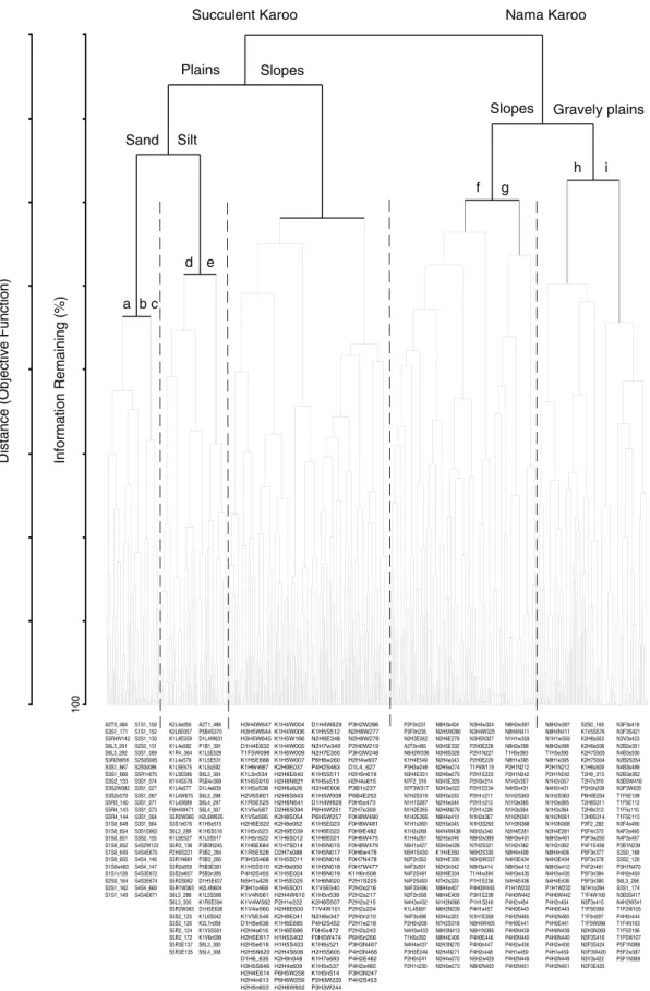
– Present a detailed but preliminary vegetation map of the northern Richters- veld.

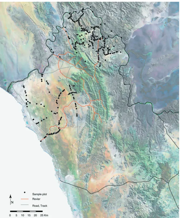
The vegetation was studied along a coast-inland transect stretching from fi xed sand dunes on the coast, along the steep mountain slopes and inner-mountain basins to the hot Orange River valley of the hinterland.

1.2. Physical environment

1.2.1. Geography and defi nition of landscape units

The Richtersveld is situated in the north-western corner of the Division of Namaqualand

in the Cape Province of South Africa. Forming the natural border between South Africa

and Namibia the perennial Orange River skirts the Richtersveld from its mouth upstream

with a big bend to the north and north-east. The longitude 17°30' marks the limit to the

east (road N 7, Vioolsdrif – Steinkopf), whereas the 29th parallel delimits the southern

part (road 382, Port Nolloth – Steinkopf). The Atlantic Ocean gives the natural border

to the west (Fig. 1.1).

(11)

Fig. 1.1: Topographical map of the Richtersveld. The frame marks the study area, which follows a climatic gradient from coast to inland (after Williamson 2000, modifi ed).

The northerly part of Namaqualand, the Richtersveld, covers approx. 8000 km

2

. It

reaches from the Atlantic to about 90 km inland. The maximum north-south extension is

120 km. The coastal plain stretches from the coast to the foothills of the escarpment in a

distance of about 40 km. The steep escarpment reaches the Central-African Plateau up

(12)

10 Introduction

to an elevation of more than 1000 m forming a climatic border. The Vandersterrberg and the Stinkfonteinberge form the north-south aligned mountain range. The Goariep mountains lies off the Vandersterrberg facing to the west. The Rosintjiebos mountains join the leeward side of the Vandersterrberg. The highest mountain of the Richtersveld, the Cornellsberg with 1374 m elevation, is part of the Stinkfonteinberge.

The Orange River has carved out a deep gap into the main mountain range especially in the north-south aligned escarpment range, forming deep gorges.

The following classifi cation and defi nition should provide an orientation to the extensive landscape under focus. Besides other habitat conditions the relief has mainly established the basis for the classifi cation. The names are given according to geomorphologic defi ni- tions. Regional names were found in topographical maps but also in ‚Tracks and Trails of the Richtersveld‘ (Reck 1996). Several names of regions, mountains or rivers were provided by indigenous people but most of them derived from European colonists, mis- sionaries and prospectors. The location of landscape units is shown in Fig. 1.2.

Namaqualand This is the northern part of the northern Cape Province in South Africa. The borders of which are: Namaland bordering to the north (Namibia), the Bushmanland section of the Karoo (northern Cape Province) to the east, and the west coast of the western Cape Province adjoining to the south.

Richtersveld It is the northern part of the Namaqualand. It is subdivided into a coastal plain and a mountainous area.

Coastal plain This plain is the northern extension of the Namaqualand Sandveld along the coast of the Atlantic Ocean (Photo A. P2). The relief of the coastal plain slowly ascends along a distance of about 40 km from the Atlantic up to the footslope of the escarpment to an elevation of about 300 to 450 m.

Coastline The plain directly bordering the Atlantic Ocean and up to ten kilometres further inland consists of white sand. Further inland from the coast longitudinal sand dunes have formed.

Inner-coastal plain It is situated ten kilometres further inland from the coast up to the fi rm sand ridge, where the white sand is successively followed by red sand. The plain is gently undulating with mainly fi xed longitudinal sand dunes.

Firm sand ridge Old reddish fi rm sand forms a long ridge which is increasingly

covered by the younger wind-blown red sand nearer to the coast, which together form

a patchy pattern. The ridge curves to about 450 m elevation where the rock outcrops

Springklipberg and Torkop are located. As the Goariepvlakte and the inner-mountain

basins of the escarpment, the fi rm sand ridge is characterised by heuweltjies or Mima-

like mounds. These are circular calcrete mounds with a different vegetation cover to that

of the surrounding matrix vegetation (see chapter 3.1.2), which give a pock-marked

appearance on aerial photographs (Villiers & Söhnge 1959).

(13)

Red dune The topographical shape of the red dune forms an almost longitudinal aligned interrogation mark with a length of 55 km and a height of 70 m from the basis to its top. The loose sand settled behind the leeward site of the fi rm sand ridge a long time ago. To the east it borders on the Goariepvlakte.

Mountain area The escarpment rises abruptly from the coastal plain to 1000 m elevation as part of the Richtersveld mountains extending to the east. The mountains have a sharp and rocky character with shallow soil pockets. The mountain area is divided into the escarpment range, its plains and basins, and the Goariep region.

Fig. 1.2: Topographical map of the Richtersveld with features of the defi ned landscape units.

(14)

12 Introduction

Escarpment range The seasonal soft winter rain has given the escarpment range more rounded valley cross-sections and surfaces. Due to lower evaporation during winter and the softness of the rain, which drains the surface, chemical weathering is possible.

The bedrock is frequently covered with a fi ne-grained soil surface.

Vandersterrberg - Stinkfonteinberge These form the escarpment range, which have a north-south alignment.

Goariep mountains (Ploegberg) The annex on the west side of the Vanders- teerberg - Stinkfonteinberge are the Goariep mountains. The annex to the east is the Rosintjiebos mountains that form a west-easterly mountain range on the same latitude of the Orange River (Oranje) mouth. The Goariep mountains are special due to its large round granite boulders and rock faces.

Koeroegab mountains A half-circle of high eastward facing mountains adjoins the northern part of the escarpment ranges, where the relief slowly descends to the deep carved Orange River valley. The mountain circle is formed by up to 950 m high mountains such as the Peilkop, Kodas Peak and Domorogh mountains surrounding the Koeroegabvlakte.

Numees mountains The northerly extension of the Vandersterrberg - Stinkfontein- berge are the Numees and Paradys mountain complex, together with the Helskloof they are known as a region of exceptionally high diversity. The Helskloof is a deep carved ravine aligned to the west and leading into the Numees valley. The eastern descent of the Numees mountains ends in a softly undulating hilly country at Die Koei, which is extensively grazed.

Plains and basins Vlakte are mainly plains with a constant downwards slope of 2° - 5° inclination. They are located on both sides of the Vandersterrberg - Stinkfontein- berge. On the west side they are adjoined to the footslopes of the escarpment and border the coastal plain (Goariepvlakte) and further north the Orange terraces (Annisvlakte, Grasvlakte), whereas, the vlakte on the east side are mainly inner-mountain basins (e.g.

Koeroegabvlakte) with a drainage system directing the scarce rainwater to the centre of the concave plains and from there to the end of the basin.

Silty plains / Goariepvlakte The Goariepvlakte is situated at the end of the Goariep foothills bordering the coastal plain and thus the red dune. It shows the typical heuweltjies or Mima-like mounds.

Numees valley This valley is surrounded by the Numees mountains (Photo A.

P6). It drains to the west into the enlarged plain Annisvlakte. Here the highest plant diversity within the park was recorded.

Koeroegabvlakte As already mentioned this vlakte is situated in the Koeroegab

mountains, draining to the east via the Kookrivier (Photo A. P9). This plain lies at a high

level as does the Springbokvlakte, about 400 to 600 m. Its surface is also strewn with

heuweltjies. The Rooiberg is located in front of this drainage system.

(15)

Abiquavlakte This vlakte lies directly adjacent to the Koeroegabvlakte and also drains to the east, but its ground level is about 100 m lower than the former (300- 450 m). This plain is similar to the one previously mentioned, also the heuweltjies reach the same density.

Armmanshoek valley This valley is situated in the lee of the Vandersterrberg - Stinkfonteinberge and in front of the Numees mountain and the Tswaies mountain ridge, draining to the east.

Rosintjievlakte This plain is situated in the corner of the Rosintjieberg and the Vandersterrberg - Stinkfonteinberge (Tswaies) exposed to the north-east. Its appearance is very similar to the Koeroegabvlakte.

Kwaggarugvlakte This vlakte is the most eastward lying silty plain. Its ground level is 500 - 700 m and is well surrounded by over 900 m high mountain ranges such as the Mount Terror of the Rosintjiebos group and the Kwaggarug mountain.

Gravelly fl ood plains / Grasvlakte The vlakte is situated in front of the escarp- ment, Numees mountains and the Fyvesusters mountains and drains to the north-west.

It has a very dry situation due to its low level of 200 - 300 m as part of the arid lower Orange River valley.

Annisvlakte The extended Annisvlakte fi lls the triangle between the high Vander- sterrberg and the Goariep mountains. It reaches the same ground level as the latter and faces to the west. It is also part of the lower Orange River valley and therefore exhibits a dry character. Furthermore, signs of over grazing mark this vlakte. The largest local herder town, Khubus, is situated below the footslope of the Vandersterrberg on the Annisvlakte.

Maerpoortvlakte Within the park, the Maerpoortvlakte shows the typical appear- ance of a gravelly fl ood plain despite being situated directly next to the Koeroegabvlakte.

It is situated east of the Koeroegab mountain cycle close to the Rooiberg, and is exposed to the south-east. Its ground level reaches from 300 to 500 m.

Springbokvlakte The most eastward and largest plain within the park is situated between the Rosintjiebos mountains and the Tatasberg. The Springbokvlakte is gently and almost perfectly symmetrically concave. From about 500 m it has a nearly constant slope down from the west to the Orange River (about 100 m).

Kokkerbomkloof Located in between the Tatasberg Complex, the Kokkerbomkloof is the highest vlakte of the park (450 - 650 m). The vlakte slopes down from the Tatasberg south-eastwards in the direction of the Orange River.

Gariep region Gariep is the indigenous name for the Orange River. The term

Gariep region determines the area surrounding the Orange River valley. The Gariep

is subdivided into a western and an eastern part due to different climatic conditions

and fl oristic compositions.

(16)

14 Introduction

Western Gariep The western Gariep, unlike the eastern Gariep, is climatically infl uenced by the Atlantic Ocean in terms of fog precipitation. Nevertheless it belongs to the arid part of the Richtersveld owing to the fact that winter rain is scarce and the elevation is low. The mountains of the escarpment extension and the terraces of the Orange River are part of this region. Near the mouth of the Orange River the western Gariep is characterised by high corrasion processes.

Western Gariep mountains The Pooitjiespramberge are situated in the north- western loop of the Orange River (Photo A. P12).

Orange River terraces The old river terraces craved by drainage lines are ordered along the slow fl owing lower Orange River as soon as the valley opens to the south-west.

Corrasion plain The area reaching from Beauvallon and Alexander Bay several kilometres to the south, is a special part of the coastal plain. In this zone of strong cor- rasion processes most of the sand has been blown away or a microhabitat of fl at and narrow longitudinal dune bodies has developed (0.5 x 2 m) alternating with nearly bare stone or crust surfaces. The diversity hot spot ‘Eastern Gariep Centre‘ is located here (Jürgens 1997, 1998).

Eastern Gariep The eastern part of the Gariep is the driest region of the Richtersveld.

In contrast to the western mountain ranges, thunderstorms with high intensity rain leads to a more superfi cial draining. This causes canyon-like valleys and craggy mountain slopes with a low amount of fi ne material or soil on the surface.

Eastern Gariep mountains The mountains of the eastern Gariep are not as high as the escarpment ranges with elevations of 300 - 400 m. The mountains of De Hoop, Kliphek and Kouams all belong to this hilly landscape. The mountains Richtersberg and Rooiberg are approx. 700 and 900 m.

Tatasberg The Tatasberg, also situated within the eastern Gariep mountains, rises to the east of the Richtersveld. Due to its elevation of more than 1000 m and a special geological formation it is described separately. The Tatasberg and Die Toon are the characteristic mountains. Such as the Goariep mountains to the west, the granite of the Tatasberg Complex weathers into large rounded boulders and rock faces that give a wondrous fairytale landscape with curiously shaped rocks. The Kokkerbomkloof is adjacent to the Tatasberg to the east.

Gannakouriep region The Gannakouriep valley is special due to its low ground

level of only 250 to 300 m within the high mountainous Richtersveld to the west and

east (e.g. Springbokvlakte: 500 m, Koeroegabvlakte: 550 m) and due to its black rock

colour and its intrusive dolerite dykes. The surrounding mountains reach 300 to 500

m. The Gannakouriep follows a tectonic line and is connected to the middle part of the

even low Abiqua valley.

(17)

1.2.2. Geology

The open mountain-desert landscape of the Richtersveld is the result of a long sequence of geological events that began 2000 million years ago. Villiers & Söhnge (1959) undertook an extensive study of the geology of the Richtersveld. In their work a detailed description of the geological formations and a map are given. Williamson (1995, 2000) gives a vivid summary of the Richtersveld geological formations and a short description of where they are exposed at the surface. This information is based on the work of Visser

Fig. 1.3: Geological map of the northern Richtersveld (data from Villiers & Söhnge 1959,

simplifi ed after Williamson 2000).

(18)

16 Introduction

et al. (1989), who established a geological classifi cation for southern Africa. A brief introduction of the main formations and their location follows in this section.

When looking at the coast-inland transect of the study area the oldest rocks lie in the eastern Gariep region (Fig. 1.3 and Tab. 1.1). The age of the geological sequences decreases from east to west. The youngest rocks and sediments are to be found along the coastal plain.

Orange River Group, ± 2000 m.y.

As already mentioned we have to look to the north-eastern part of the Richtersveld for the oldest rocks, where the eastern Gariep mountains are restricted by the Orange River, its loops turning from west to north. Here the Paradys mountains, the Rosintjiebos mountains and the De Hoop mountains are included. The pink coloured rocks of lava, porphyry and tuff are the remains of an ancient belt of island volcanoes.

Vioolsdrif Suite, 1900 - 1700 m.y.

The younger Namaqualand basement granites of the Vioolsdrif Suite intrude into the rocks of the Orange River Group. In two north-west-south-easterly aligned bands the orange-brown granite-gneiss nestles among the older rocks: One band spans from the escarpment leeward descent to the central Richtersveld mountain section with the Pooitjiespramberge, Koeroegab mountains, Rooiberg, Maerpoort and Gannakouriep mountains. Southwards, behind the rocks of the Rosintjieberg Formation of the Orange River Group the rocks of the Vioolsdrif Suite continue. The other band is adjacent to the De Hoop Subgroup of the Orange River Group to the east, fi lling the north-easterly loop of the Orange River.

Gannakouriep Suite, 870 - 540 m.y.

During a long geological period the crust of the earth was uplifted and fractured.

This dynamic period and fracturing led to the intrusion of magma welling up through the rocks of the Vioolsdrif Suite. Crystalline, dolerite dykes up to one kilometre wide were formed. These black dykes stretch almost south-north along the Gannakouriep valley and between the Sendelingsdrif and the Koeroegabvlakte.

Gariep Complex, 660 - 500 m.y.

The Stinkfontein Formation, comprising the oldest rocks of the Gariep Complex dated

at 660 million years old, lies between the older rocks of the Orange River Group and

the Vioolsdrif Suite on the eastern side and the younger Gariep rocks to the west. It is

suggested that the sediments derived from the mountains of the Rosintjieberg Formation

to the east and were deposited on the westerly footslopes of these ancient mountains

under wet climatic conditions during a cold glacial period. Evidence for this hypothesis

are the presence of sedimentary breccias, which represent consolidated scree and talus

(19)

derived from the ancient rocks of the Rosintjieberg Formation. The absence of limestone indicates that the sediments were deposited comparatively near to their source under fl uvial conditions (Villiers & Söhnge 1959). These sediments of resistant quartzite, pink feldspar-rich sandstones and prominent conglomerates, terminated in the unfolding and birth of the modern Vandersterrberg - Stinkfonteinberge (Williamson 2000).

The adjacent sandstones, conglomerates, shales and dolomitic sandstones of the Hilda Suite were deposited on the edge of a shallow ocean 580 million years ago under glacial conditions. The sediments of the Hilda Suite are situated along the eastern Orange River, the eastern Gariep, south of Sendelingsdrif, extending to the Grasvlakte and Helskloof.

Some occurrences can be found near Khubus. The tillites of the Numees Formation were

almost simultaneously deposited both north and west of the Vandersterrberg, under simi-

lar conditions. The sediments of the Holgat Suite, consisting of a large assemblage of

rock types with typical tillites towards the top of the sequence, are the result of a slower

deposition. The sediments of the Holgat Suite extend from the rocks of the Hilda Suite

to the present coastline. To the north-west the Gariep Complex continued with the devel-

opment of the Grootderm Suite rocks 500 million years ago. These rocks of fl at to low

hills originate almost entirely from volcanoes. Schist, greywacke and quartzite overlie

the volcanic rocks. The cycle of the Gariep Complex is completed by the Oranjemund

Tab. 1.1: Time scale of the geological events in the Richtersveld. (after Williamson 2000,

modifi ed).

(20)

18 Introduction

Suite that is situated in the north-west corner of the Richtersveld, at Oranjemund. Today the present coastal sand plains overlie the rocks of the Gariep Complex.

Tatasberg Complex and Kuboos Pluton, 530 - 500 m.y.

The Tatasberg and Goariep mountains complexes were simultaneously formed by the igneous intrusion of magma. The Kuboos Pluton of the modern Goariep mountains intruded into the Gariep Complex on the west side of the Vandersterrberg - Stinkfon- teinberge, whereas the Tatasberg Complex intruded into the oldest rocks of the Orange River Group and the Vioolsdrif Suite in the eastern Gariep region.

Dwyka, ± 300 m.y.

During the Great Ice Age large glaciers moved over the Nabas basin situated at the lower Springbokvlakte. The mud and turbid layers deposited were formed by the ice sheets and abraded the underlying rocks. After the ice had melted, further metamorphism developed orange, pink, brown and black pavements of tillites.

Alluvium, sand, calcrete, 50 m.y.

The drainage system with drainage lines and wide valleys was already established during the Cretaceous period. After the late Cretaceous the climate changed to more arid conditions. At the beginning of the Tertiary period the tributaries of the Orange River dried up completely and the deeply incised valleys became choked with rock-waste and sand, partly wind-borne but largely brought in by surface water (Villiers & Söhnge 1959). The surface of all these sand-choked valleys such as the Springbokvlakte, the Maerpoortvlakte and the Annisvlakte is composed of granite grit with remarkably little fi ne material. It is suggested that the fi ner material was partly removed by wind action and deposited in adjacent areas. Much of the sand is now collected in dunes on the coastal plain, for example. Due to higher rainfall in the vicinity of the high mountain ranges (Vandersterrberg - Stinkfonteinberge), the footslopes, such as of the Goariepvlakte and inner-mountain basins e.g. the Koeroegabvlakte and the Abiquavlakte, received suf- fi cient water to maintain a vegetation capable of preventing the stripping of the surface soil and accumulating large quantities of rock-waste as well as fi ner material (Villiers &

Söhnge 1959).

Today strong thunderstorms are observed in the eastern triangle of the Rosintjiebos

mountains and Vandersterrberg - Stinkfonteinberge, coming from the east during the

summer. Similar observations are made for the vicinity around Sendelingsdrif. During

these thunderstorms a large quantity of water falls in a short time and the surface of

the sandy plains, such as the Springbokvlakte, begins to move, so that extended mud

masses from the whole plain slip down to the lower Orange valley. This type of plain is

therefore called a sheet wash plain. This could also be one reason for the fl atness and

coarseness of the sandy plains as the fi ne material is additionally removed by water

(21)

action. The cyclonal rain in winter falls softly and over a long period so that the raindrops penetrate the dry surface of the plains obviously in the western part of the Richtersveld.

Erosion is dominant in the eastern part, due to low surface drainage.

At the same time as the valleys and plains were chocked with rock-waste, the clayey sandy soil of the coastal belt was developed under hot conditions. These have been exposed where the wind-blown sand has been removed by wind action. This reddish fi rm sand is characterised by a prolifi c development of more or less circular pimple mounds of calcrete (Mima-like mounds, see chapter 3.1.2.1), which can also be observed on the silty sands of the inner-mountain basins of the mountain region. It is inferred that the sand was formed mainly by the decomposition of the underlying formations, owing to the fact that no fossils were be found in the fi rm sand of the coastal plain. This process could have taken place under weathering conditions between dunes whilst the latter were still shifting and also after they had become more or less fi xed (Villiers and Söhnge 1959). The wind-blown sand, which forms these dunes, has its origins possibly from the extended surfaces of the arid sandy plains within the mountain region, as previously mentioned.

During the Pleistocene period, the retreat of the sea caused a further lowering of the coastal area so that parts of the continental shelf were uncovered. River terraces were left exposed and due to further lateral erosion, these diamondiferous terraces were laid bare. These terraces lie along the lower Orange River valley in the western Gariep (Williamson 2000) and are today the focus of the mining companies.

1.2.3. Soils

The soils of arid regions are mostly weakly developed. After the low water resource, which reduces the chemical weathering, the wind in combination with low vegetation cover is the main impediment to pedogenic processes. Low precipitation with simultaneously high transpiration leads to reduced washout and little movement of clay.

On the other hand readily soluble salts are enriched at the surface by ascendant soil water that causes basic pH-values. The humus portion is low (under 1 %).

The infi ltration of water is impeded, because the air of the soil pores could only slowly leak out of the dried soils. The highest infi ltration rate is reached by substrates of homo- geneous grain size and a low portion of fi ne material (Besler 1992). This is true for e.g.

sands. Typical for the soils of the study area is the development of crusts by local solution

and concretion processes. At the coastline gypsum crusts predominate, whereas inland

the occurrence of lime crusts increases (Besler 1992). While it is suggested that lime

crusts are a product of a fossil development during a pedogenic period (Besler 1992),

the gypsum crusts could also have developed under recent climatic conditions (Watson

1988). The soil surface is often protected against erosion by a 1 mm thin physical and

microbiotic crust.

(22)

20 Introduction

Although a detailed soil classifi cation and map of the Richtersveld was not available, several studies have focused on the soil properties of the Richtersveld and their ecological value for the vegetation. Jähnig (1993) investigated several selected soil catena, whereas Boenigk (1998) and Osterloh (2000) studied the soils of the stock posts. Oguz (1999) and Stöcker (1999) worked on the vegetation and soil properties of the Sandveld.

According to the FAO (1989) the soils of the Richtersveld belong to the main soil groups of arenosols, on the coastal sand plain (Sandveld), and leptosols within the mountain region. Arenosols are characterised by their low pool of weatherable minerals and their low silt/clay to sand ratio. The parent material is aeolian sand or sands derived from aeolian deposits. Leptosols are shallow soils with weak profi le differentiation.

South Africa has its own soil system according to the classifi cation of Van der Merwe (1962), which is based on climatic features. In the reclassifi cation of Loxton (1962) and in the map of Harmes (1978), based on the classifi cation of Van der Merwe, the soils are subdivided by their morphological and genetic characteristics. A more detailed map for the soils of the Karoo, presented by Ellis (1986), orders the soils to the main landscape units. This focus pays less attention to the soil characteristics but stresses the categorisa- tion of landscape units. By collecting the most important soil characteristics for every landscape unit, the soil characteristics are strongly standardised or left unnamed.

1.2.4. Climate

The climate of the western coast of southern Africa forms a complex situation that has similarities with other regions of the world. The aridity of the Namib Desert is caused by its close vicinity to a cold sea current parallel to the coast - the Benguela current, this effect can also be found in the Sechura Desert (Peru) and in the Atacama (Chile).

The cold surface of the sea leads to a descent of the air masses which in turn builds up an inversion layer. This inversion layer, which is further stabilized by the south-eastern trade winds, prevents the ascent of air masses and therefore condensation and resulting precipitation.

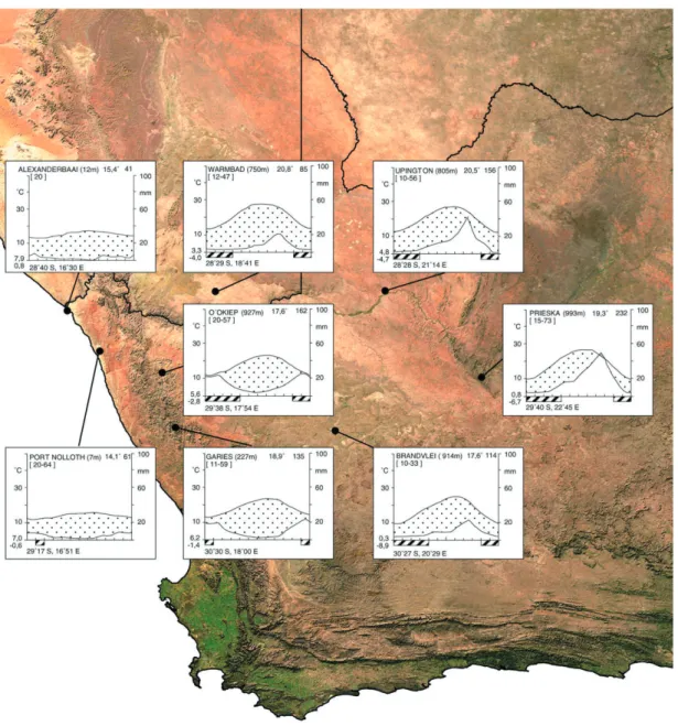
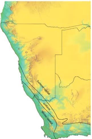
According to the climatic data available and model outputs (Schulze et al. 1996) the climate of the Richtersveld and adjoining areas clearly shows a transient character (Fig. 1.4). Two major climate regions border along the north-south aligned mountain ridge of the escarpment: The warm temperate winter rainfall on the west side and the non-seasonal rainfall on the east side (Fig. 1.5). The regular summer rainfall regime is adjoined further east and to the north.

The west wind drift reaches the southern Namib only in winter when the ITCZ (Inner

Tropical Convergence Zone) migrates further north. Precipitation within this zone occurs

during the coldest months of May to September, varying from c. 50 mm p.a. at the

coast, c. 100 mm in the valleys and lowlands, to >150 mm on the Richtersveld mountain

(23)

tops. The precipitation rate in the non-seasonal rainfall zone is low, unpredictable, and rain often falls in intensive thunderstorms, as is normally observed under summer rain conditions.

The descending air over the cold sea surface condenses and develops fog banks.

The Atlantic-Benguela anticyclone causes strong sea mists to fl ow eastwards over the coastal plain and into the low-lying Orange River valley, especially in winter when the zenith position of the sun is well to the north. The reduced radiation load results in rather cold temperate conditions. In contrast, the temperature in the mountains of the escarpment varies considerably from winter to summer, and the diurnal amplitude is high. There is an increased probability of frost at higher altitudes and further east into the interior, and the cold winter temperatures are frequently interrupted by hot easterly

Fig. 1.4: Climatic diagrams of eight meteorological stations located within the north-western

Cape Region (Walter & Lieth 1965).

(24)

22 Introduction

Fig. 1.5: The two major climate regimes, winter rainfall and summer rainfall on the western coast of southern Africa. The winter rainfall regime borders a zone of low, non-saisonal precipitation that is followed farther inland to the east and north by the summer rainfall regime proper.

„berg winds“. Cold air masses, on the plains of the old land surface further inland, slowly fl ow westwards following the relief descent from the east (Drakensberge) to the west of the African plate and fall down abruptly along the escarpment descent. Stormy hot winds reach the footslopes of the escarpment and the coastal plain along with the adiabatic increasing temperature.

1.3. Biotic settings

1.3.1. Flora and vegetation Flora

The fl ora of southern Africa is, with about 21000 indigenous species (Arnold & De Wet 1993), among the richest in the world for similar sized areas (Goldblatt 1978; Gibbs Russell 1985; Cowling et al. 1989; Cowling & Hilton-Taylor 1994, Cowling & Hilton- Taylor 1997). The Succulent Karoo records more than 5000 species per 100251 km

2

, which is the highest species richness for semi-arid vegetation, out of which 50 % are endemic (Cowling et al. 1989, Milton et al. 1997).

The fl ora of the Richtersveld contains about 1615 species up to now, from which 140

species are endemic (Williamson 2000). The majority of the endemic species occur on

(25)

the higher altitudes of the escarpment as well as along the Orange River valley (Gariep).

Some of the species, mainly belonging to the most common family of the Richtersveld, the Mesembryanthemaceae (50 genera with 255 species), have not been described up until now. The families Asteraceae and Crassulaceae are highly represented with 200 species of 27 genera and 88 species of four genera (Williamson 2000). The fl oristic recording of the Richtersveld fl ora is mainly attributed to van Jaarsveld (1980, 1981, 1989, 1992, 1994), Williamson (1990, 1992, 1994, 1995, 1998, 2000), Leach (1984), Manning (1990), Midgley (1997), Pierce (1997) Gerbaulet & Schollenberger (1993).

Phytogeography

A detailed review of early research on phytogeography of southern Africa is compiled by Cowling & Hilton-Taylor (1997 with comprehensive literature). Based mainly on their work some remarkable points of the development are given in this section.

Bolus (1875, 1886, 1905), Rehman (1880), Engler (1882) and Marloth (1887) recognized a south-western region (Cape Region), a Karoo region, a Kalahari region and eastern seaboard region in their early attempts to divide the sub-continental fl ora.

These examinations led to the subdivision in a Cape Floristic Kingdom for the Cape region and a distinct Palaeotropis Kingdom, which covers the rest of the subcontinent (Takhtajan 1969). A fi ner subdivision of the area resulted from examinations by Marloth (1908), Pole Evans (1922) and Acocks (1953). Lebrun (1947), Monod (1957), White (1965, 1971), Troupin (1966) and Good (1974) defi ned the subcontinent’s phytoge- ography in an Africa-wide context. Werger (1978a) combined the work of his pred- ecessors into a synthetic phytogeographic map for southern and South-Central Africa.

The phytogeographic systems of Werger (1978a, 1986) and White (1971, 1976, 1983) are the most introduced and widely accepted (Jürgens 1991, Cowling & Hilton- Taylor 1997). White (1976) subdivided the fl ora of southern Africa into six different units: Cape Region, Afromontane Region, Tongaland-Pondoland Region, Karoo-Namib Region, Kalahari-Highveld Transition Zone and Zambezian Region. Werger (1978a) also defi ned a Karoo-Namib Region, which falls entirely into the Palaeotropis. Further- more his subdivision differs in some respects from the phytochorological subdivision of White (1976). Werger ordered the fl ora into seven different units: Guineo-Congolian Region, Indian Ocean Coastal Belt, Sudano-Zambezian Region, Afromontane Region, Afro-alpine Region, Karoo-Namib Region and Capensis.

Jürgens (1991) proposed a split of the Karoo-Namib Region sensu Werger (1978a)

and White (1976,1983) into two major units, the Succulent Karoo Region and the Nama

Karoo Region (Fig. 1.6). The separation into two different fl oristic regions was necessary

because the Karoo-Namib Region was counted to belong to the Sudano-Zambezian

Region of the Palaeotropis (Werger 1978a). Only the Nama Karoo Region is part of the

Palaeotropis, the taxa of the Succulent Karoo show fl oristic relationships to the Greater

Cape Flora. Jürgens (1991) subdivided the Greater Cape Flora into the Cape Floristic

(26)

24 Introduction

Region and the Succulent Karoo Region, whereas the Nama Karoo Region is part of the Palaeotropis such as the Sudano-Zambezian Region. The Succulent Karoo Region is fur- ther subdivided into the Namaqualand-Namib Domain and the southern Karoo Domain.

The Nama Karoo Region is split into the Namaland Domain, the eastern Karoo Domain and the Damaraland-Kaokoland Domain. Within the Richtersveld-Namib area Jürgens (1991) (Fig. 1.7) proposed a further separation of the Namaqualand-Namib Domain into the southern Namib District (Namibian west coast), to which the western Gariep Circle/Centre of the lower Orange River valley is counted, the Namaqualand-Sandveld District (South African west coast) and the Richtersveld Mountain District (mountainous region of the Richtersveld). The adjacent part of the Nama Karoo Region in the east is the eastern Gariep District of the Namaland Domain.

Biomes of southern Africa

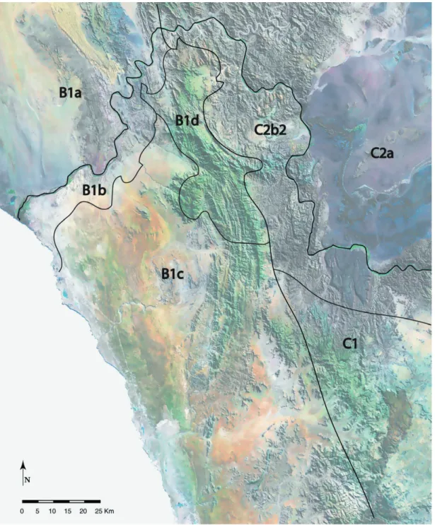
Fig. 1.6: Phytogeographic division of the Karoo-Namib Region after Jürgens (1991). The Grater Cape Floral Kingdom comprises the Cape Floristic Region (A) and afromontane regions further east, and the Succulent Karoo Region (B). The Palaeotropical Kingdom comprises the Nama Karoo Region (C), the Sudano-Zambezian Region (D), and other phytochoria to the north and east. The Nama Karoo Region is subdivided into: 1

= eastern Karoo Domain; 2 = Nama- land Domain (subdivided into a = Namaland Subdomain, b = Namib Subdomain, b

1

= Namib District, b

2

= eastern Gariep District) and 3

= Damaraland-Kaokoland Domain

(redrawn from Jürgens 1991).

(27)

Fig. 1.7: Phytogeographical division of the Richtersveld according to Jürgens (1991). Abbrevia- tions (underlined are the fl oristic units that are represented in the Richtersveld):

Greater Cape Flora Palaeotropis

A — Cape Floristic Region C — Nama Karoo Region

B — Succulent Karoo Region 1 — eastern Karoo Domain

1 — Namaqualand-Namib Domain 2 — Namaland Domain

a — southern Namib District a — Namaland Subdomain

b — western Gariep Circle b — Namib Subdomain

c — Namaqualand Sandveld District b1 — Namib District

d — western Richtersveld Mountain District b2 — eastern Gariep District

2 — southern Karoo Domain 3 — Damaraland-Kaokoland Domain

D — Sudano-Zambezian Region

(28)

26 Introduction

Fig. 1.8: Dominance or co-dominance of four plant life form sets in relation to biomes. Phanero- phytes are depicted on the right, chamaephytes below, hemicryptophytes above and therophytes on the left. The biomes are: FO = Forest; G = Grassland; SK = Succulent Karoo; D = desert; NK

= Nama Karoo; S = Savanna and FY = Fynbos (redrawn from Rutherford (1997).

Rutherford and Westfall (1986) identifi ed seven biome units for southern Africa based on the dominance of four plant life forms, phanerophytes, chamaephytes, hemicrypto- phytes and therophytes (Fig. 1.8). The seven biomes are Desert, Grassland, Savanna, Succulent Karoo, Nama Karoo, Fynbos and Forest. Uni-dominance of phanerophytes (P), chamaephytes (Ch), hemicryptophytes (H) and therophytes (T) represent the Forest, Succulent Karoo, Grassland and Desert biomes. Intersection sets determine the Savanna (H, P), Nama Karoo (H, Ch) and Fynbos (H, P, Ch). The Desert biome contains a few areas of co-dominance with chamaephytes or with hemicryptophytes in areas of transi- tion to Succulent Karoo and Nama Karoo (Rutherford 1997). The biome units are not determined on the basis of fl oristic or phylogenetic composition; therefore a coincidence with phytochoria is not necessary. Independent studies (Gibbs Russell 1987, Cowling et al. 1989, Jürgens 1991) on the species relationships among the main biomes showed a fl oristic distinction of each biome, except to some extent the Nama Karoo (forest was not analysed) (Rutherford 1997).

Phytosociological research in the Richtersveld

Published studies on the phytosociology of the study area and the vicinity have

been scarce up until now. Jürgens studied the vegetation of the Richtersveld for about

18 years. More than 1000 relevés form the basis of the vegetation map that is

in preparation by Jürgens. The National Botanical Research Institute in Windhoek

joined the phytosociological work for a vegetation map of Namibia, which is also

in preparation (Strohbach & Sheuyange 2000). The phytosociological studies of

Le Roux (1984) form the basis for a vegetation map of southern Namaqualand.

(29)

Phytosociological studies for the Karoo Region (Werger 1978b, Werger & Coetzee 1978) also exist.

Vegetation history

A comprehensive account of the vegetation history of southern Africa is presented by Scott et al. (1997). According to this the vegetation dynamics during the Quaternary period for south-western Africa is briefl y summarized here.

During the Quaternary, and probably before, modern biomes were already well established. The evidence for this suggestion is derived from old pollen profi les of the Pretoria Saltpan and Port Durnford. During this period marked cycles of vegetation change occurred which resulted in wide shifts in biome composition and boundaries.

A transition from cooler to warmer climatic conditions in a constant dry environment is assumed for the late Pleistocene to the early Holocene. A shift within the fl oristic assem- blages is shown in the preliminary palynological data from spring deposits at Eksteenfon- tein, Richtersveld. The assemblages of predominantly Chenopodiaceae / Amaranthaceae type and certain Asteraceae pollen before 10700 BP changes to assemblages totally dominated by pollen of the Aizoaceae / Mesembryanthemaceae type 10700 - 8450 BP (Scott et al. 1995). This climatic change could also have had an effect on the Cape region where pollen data from the Cedarberg show that more succulents occupied the northern Fynbos at c. 8000 BP (Scott 1994). Therefore the Succulent Karoo boundary may have moved southward during that period.

Scott (1987b, 1996), Beaumont et al. (1992) suggest a much wider distribution for the Nama Karoo biome in the interior of southern Africa by the end of Pleistocene (c. 10400 BP) than at present (records from Equus and Wonderwerk, southern Kala- hari). The portion of grasses in the Nama Karoo increased from the early to the middle Holocene (Bousman et al. 1988, Scott 1993) but the grass to shrub ratios continued alternating. Brain & Brain (1977) inferred from micro mammalian evidence (Mirabeb Shelter) that the desert biome was grassier at c. 6500 BP. Scott et al. (1997) conclude that early types of Fynbos, semi-arid, succulent scrublands and desert vegetation of the south-western Cape, the west coast and the Karoo, only became established by the end of the Miocene, i.e. more or less at the same time as modern plant communities on other continents.

Vegetation history of the Holocene

The establishment of succulent rich dwarf shrub-land or grassland in Namaqualand took place by the late Pleistocene (Scott 1995) as the climate changed from cooler to warmer conditions. The karroid scrubland was forced back to the inland in the east.

During the Holocene the Nama Karoo biome resisted in its formation character but the

portion of grassy hemicryptophytes and phanerophytes were subject to fl uctuations in

response to temperature and moisture. During cooler and wetter conditions the portion

(30)

28 Introduction

of perennial grasses and woody taxa increased, whereas it decreased under warmer and drier conditions.

The archaeo-zoological remains, tentatively identifi ed as blesbok, point to greater grass cover in the eastern Richtersveld at 2000 BP (Webley 1993) compared to the recent vegetation composition with a low portion of grasses. The charcoal remains could probably originate from more substantial woody vegetation than is presently found. The archaeological remains led to the conclusion that there was higher precipitation in the eastern Richtersveld at 2000 BP than today (Webley 1993).

1.3.2. Present and former land use - history of the Richtersveld National Park

Former land use

Since the early Stone Age the environment of the Karoo has been impacted by human use. While the economies of the inhabitants is not well-known, it has been established that the diet of Homo erectus consisted mainly of large mammals such as elephant, rhino, hippo, giant alcelaphine, giant buffalo and smaller animals such as pigs and bushbuck (Klein 1988). It is assumed that humans chased other carnivores away from their kills in order to obtain meat food (Smith 1999).

Unlike Homo erectus, H. sapiens were capable of hunting animals, which are bigger than themselves on the basis of a newly developed tool technology. The fl ake tools for example were hafted onto a wooden shaft that could be thrown. The transition of H.

erectus to H. sapiens is presumed to have taken place around 250000 years ago.

The humans of the early and middle Stone Age were obviously hunter and gatherers.

Vincent’s study (1985) gives indications that exploitation of underground plant foods such as geophytes took place in the Savanna zone of East Africa and maybe also in the Karoo.

The appearance of modern people, H. sapiens sapiens, probably occurred during the later Stone Age, around 40000 years ago (Smith 1999). A new phase of development derived from these modern people, including a social organization based on family life, sexual division of labour and equal distribution of product. Reliable resources allowed the hunters to stay in one place for most of the year, which resulted in food storage. Such economic wealth can create surplus and leads to an increasing population density.

Roughly 2000 years ago the fi rst agricultural humans appeared in southern Africa.

They brought domestic animals and plants and pottery with them. With their appearance

the aboriginal hunter and gatherers fell under existential pressure. The increasing

impact on the hunter was slow in the beginning but it gradually pushed them more and

more onto marginal grazing lands. This was mostly due to the fact that the pastoralist’s

(31)

domestic animals competed for the grazing land with the hunter‘s traditional prey spe- cies, which in the end was drastically reduced (Smith 1999).

For the period of ca. 3800 to 3100 BP Webley et al. (1993) found evidence of hunter-gatherer occupation in the Richtersveld, which were derived from an excavation site at Die Toon (north-eastern Richtersveld). The distance of the site to the Orange River is at least 15 km in both the easterly and northerly direction. This is probably the reason for the very rare occurrence of archaeological deposits, indicating only brief visits to the site, possibly only in years of partially good rainfall. Archaeological work in both south- ern Namibia and Namaqualand suggest an increase in population density after 2000 BP, which may be linked to the arrival of pastoralist groups in this area introducing the domestic sheep (Webley et al. 1993). On the banks of the Orange River at Jakkalsberg (north-west of the Richtersveld) two pastoralist sites were discovered, dated around 1300 BP (Brink & Webley 1996, Miller & Webley 1994, Webley 1997). Faunal remains are predominantly those of young sheep. The site at Bloeddrift (north-west of the Richtersveld) gives evidence of both hunter and pastoralists dated around 355 BP (Smith 2001).

The Orange River and its hinterland were predominantly inhabited by Khoisan societies in the 18th century (Penn 1995). The San people were hunter and gatherers occupying the high lying regions to the east and south-east, whereas the Khoi pastoralists herded their livestock on the Orange River islands. The Khoi societies were split into the Little Namaqua living in the Little Namaqualand, located south of the Orange River, the Great Namaqua of the Great Namaqualand, which was situated north of the Orange River (today known as Namaland), and the Einiqua occupying the east.

The San people were divided into the Sandveld San on the western coast of Namaqualand and the Bushmanland San living in the Bushmanland, Kalahari. The Sandveld San worked as clients for the Namaqua and received protection from this dominating society. However, not all San worked for the Khoi. The more powerful Bushmanland San were enemies of the Namaqua.

During the 18th century the European colonists, coming from the Cape region, pushed slowly but unstoppably forward to the north. Namaqualand served for a long time as a rear guard area against European settlers for Khoekhoe and other displaced groups of the Cape because of its seclusion in the period of colonisation. Few expeditions occurred within this time such as that of Commander Simon van der Stel who led the fi rst Europe- ans to the Namaqualand in 1685. The Europeans learned from this expedition that the Namaqua were rich in cattle but not numerous. They counted eight to nine kraals (Penn 1995). Encouraged by this experience Europeans began to settle in Namaqualand in 1750 as ivory hunters or livestock traders and raiders. Nineteen white stock-farmers were reported in Namaqualand during this period (Penn 1995).

By 1780 the river had become a zone of terror, as a consequence of the colonial

impact shattering the old order, transforming the pre-existing social and economic

(32)

30 Introduction

networks and introducing an era of violent insecurity. Frontier men of varied origins (Europeans, slaves, „Bastaards“, Khoi, „Bastaard-Hottentots“, San and Oorlams) formed predatory commando gangs which robbed weaker groups of their livestock. The mis- sionaries began their activities during this period of chaos and destruction. The fi rst missionaries arrived in the frontier zone in 1799. In the condition of anarchy, which had accompanied the disintegration of traditional societies along the river, conversion to Christianity offered social, political and economic advantages (Penn 1995).

In 1805 the London Missionary Society started in Namaqualand. More than three decades later (1840) the London Missionary handed over to the ‚Rheinische Mission- sgesellschaft‘ (Berzborn 2002). The mission stations gave the local people protection against the Bure and Basters, because the colonial government assured the indigenous people the access to the land around the mission stations (Strassberger 1969 in Berzborn 2002). Through this system, the pastoral-nomadic economy continued to be possible in the Richtersveld. This was not true for the region around the western Cape at the end of the 19th century because white settlers occupied extensive land. The mission station

‚Richtersveld‘, around which the village Khubus had developed, was set up in 1842.

In December 1847 Namaqualand was integrated into the Cape colony (Berzborn 2002).

In the 20th century, during the apartheid regime, the Richtersveld was one of fi ve similar administrative areas situated in the north-western Cape which were demarcated as Rural Reserves Act of 1957 (Carstens 1966 in Mussgnug 1995). The other four reserves being Komaggas, Concordia, Leliefontein and Steinkopf. Many people of different ethnic groups were displaced from the Cape region to the Richtersveld. These people live today in the villages Eksteenfontein and Lekkersing (Berzborn 2001). During apartheid the indigenous language Nama was forbidden in the schools. Therefore Afrikaans is the language most widely spoken in the Richtersveld today. Since the breakdown of apart- heid the political climate has changed. Personal development and a new-formed identity gained more signifi cance. The Nama found the way back to their traditional authority structure and their language. The government and the NGO’s supported them in their efforts. The support of Nama is becoming a symbol of winning back freedom and ethnic identity in the post apartheid period. The language Nama has been re-introduced into the school at Khubus since 1999 (Berzborn 2002).

Recent land use

The traditional life-style of the Nama people was based on nomadic pastoralism. This

economic system has mainly dwindled in southern Africa, the Richtersveld being one of

the last regions to preserve it. It is well adapted to arid regions. The herders and their

(33)

fl ocks move over long distances to overcome the scarce and erratic precipitation, thus avoiding the over grazing that would follow a sedentary life-style (SANP 1997).

Socio-economic and political factors have caused a transition from a fully nomadic way of life to one of semi-nomadism. In the northern Richtersveld most stock farmers have permanent homes in the villages of Khubus or Sanddrif and occupy stock posts while herding their fl ocks (SANP 1997). These stock posts are distributed throughout the Richtersveld, along the Orange River valley and within the mountain region with its footslopes. As a type of transhumance the movement of the farmers and their fl ocks follow the seasonal rhythm of precipitation. The smallstock herders make use of the graz- ing along the Orange River in the dry summer, when goats and sheep may drink twice a day from the river, while moving to the foothills of the mountains in winter after the rainfall. This protects the evergreen Orange River valley against over grazing, while the short spring fl owering of ephemeral meadows is optimally exploited. The fl ock mainly consists of goats; only a small number of sheep or cattle are added. The goats are able to resist drought by obtaining all of the water necessary out of the green, mostly suc- culent vegetation. Whereas, sheep and cattle have to drink water once or twice a day (Mussgnug 1995).

Richtersveld National Park

In 1991 an area of 162444 ha in the northern Richtersveld was declared a national park. The management plan for the Richtersveld Park is unique to southern Africa.

While in other national parks the indigenous habitants were forced to leave their land, the Nama of the Richtersveld are part of the park management. The land belonged to the Nama people, and without their consent and cooperation the establishment of a national park was not possible. The Richtersveld communities and the National Parks Board jointly manage the park. „The management plan identifi es two major conservation objectives of equal importance: the preservation of the traditional life-style and culture of the Nama people together with associated forms of sustainable use of the land and conservation of the great biodiversity and essential ecological processes that character- ise the Richtersveld.“ (SANP 1997). Altogether 26 herders and their families have the right to use the land within the park for their traditional semi-nomadism, but the grazing is restricted by certain rules. The number of livestock within the park is limited to 6600 Small Stock Units. One Small Stock Unit is one goat or one sheep and one cattle is the same as fi ve Small Stock Units.

The lack of large wild mammals in the Richtersveld is a result of the activities of European hunters over the last hundred years. Most of the large mammals were totally exterminated. Certainly, the park’s attractiveness for the tourists will increase through the re-introduction of wild herds of antelopes or zebras etc.

While the northern part of the Richtersveld is used as communal land, the southern

part has been separated into economic units since 1984, as in the whole Namaqualand

Abbildung

Fig. 1.1: Topographical map of the Richtersveld. The frame marks the study area, which follows  a climatic gradient from coast to inland (after Williamson 2000, modifi ed).
Fig. 1.2: Topographical map of the Richtersveld with features of the defi ned landscape units.
Fig. 1.4: Climatic diagrams of eight meteorological stations located within the north-western  Cape Region (Walter & Lieth 1965).
Fig.  1.5:  The  two  major  climate  regimes, winter rainfall and summer  rainfall  on  the  western  coast  of  southern Africa
+7

Referenzen

ÄHNLICHE DOKUMENTE

The point is somewhat a matter of water mass definition and the particular isopycnal or level in question, but again the flow scheme here simply implies that

For East Africa, Buigut and Valev (2005) test the symmetry of underlying structural shocks in the region and find that supply and demand shocks are

Estimation of "challenge" The steps in the calculation of estimated numbers of infective bites from G pallidipes containing T congolense received by each cow in the herd at Diani

1989b: (Paläo-)Klima und Relief: Das Reliefgefüge der südwestafrikanischen Namib- wüste( Kunene bis 27° s.B.). Vogel 1988: Late Quaternary environmental changes in the northern Namib

In the central Namib a climatic regime entirely different from that of stage 2 and 1 existed; although the climate was arid to semi-arid, it was characterized by several

Daraus ergibt sich die Schlußfolgerung, daß fluviale Sedimente und Formen in der Namib nur eingeschränkt als Paläoklimaindikatoren benutzt werden können und daß nur über

The evidence from the Rössing Cave speleothems suggests, however, that incision of the Kuiseb subsequent to 28,000 BP was caused not only by increasing rainfall intensity in

PRELIMINARY RECONSTRUCTION OF" THE LATE QUATERNARY CLIMATIC HISTORY OF THE CENTRAL NAMIB DESERT, SW AFRICA, BASED ON NEW 1 4 C DATES.. In the course of a project