What is the impact of a UNESCO status due to visitors on the environment of Herschel Island?
-
A survey of the influence of trampling on vegetation
Kira Heinemann (Student number: 769688)
A master thesis presented for the degree of Master of Ecology, Evolution and Conservation (M.sc.)
Institute of Biochemistry and Biology Faculty of Science
University of Potsdam
First Tutor: Prof. Dr. Hugues Lantuit Second Tutor: Prof. Dr. Ulrike Herzschuh
Date: June 19, 2019
Contents
List of Abbreviations 8
Abstract 9
1. Introduction 11
2. Aim of the Thesis 14
3. Background 15
3.1. Herschel Island Qikiqtaruk . . . 15
3.2. Ecology of Herschel Island . . . 16
3.2.1. Ecological Classes . . . 17
3.2.2. Soil . . . 21
3.3. Structure of Administration . . . 22
3.3.1. Inuvialuit Final Agreement . . . 23
3.3.2. Management Plan . . . 25
3.4. Tourism . . . 26
3.4.1. Last Chance Tourism . . . 26
3.4.2. Arctic Tourism . . . 27
3.4.3. Tourism on Herschel Island . . . 29
3.5. UNESCO and World Heritage . . . 31
4. Methods 34 4.1. Development of Number of Visitors . . . 34
Contents
4.2. Vegetation Analysis . . . 35
4.2.1. Walking Trail for Cruise Ship Tourists and Impact on Vegetation . 35 4.2.2. Hot Spot Analysis of Research Impact on Vegetation . . . 36
4.2.3. Additional Insight into the Environment via Photographs . . . 37
4.3. Impact on Permafrost . . . 37
4.4. Evaluating the Effects of UNESCO . . . 38
5. Results 40 5.1. Development of Number of Visitors . . . 40
5.2. Vegetation Analysis . . . 41
5.2.1. Walking Trail of Cruise Ship Visitors . . . 41
5.2.2. Hot Spots and Cold Spots of Conducted Research of AWI . . . 45
5.2.3. Additional Insight into the Environment via Photographs . . . 47
5.3. Comparison of UNESCO Guidelines and Herschel Island Management Plans 49 6. Discussion 52 6.1. Impact of Visitors due to Trampling on Vegetation . . . 53
6.1.1. Impact Dependent on Ecological Classes . . . 53
6.1.2. Impact Dependent on Intensity of Trampling . . . 57
6.1.3. Impact of Trampling on Vegetation Compared to Other Disturbances 59 6.2. Impact of Visitors due to Trampling on Permafrost . . . 60
6.3. Visitor Development on Herschel Island . . . 62
6.3.1. Development of Number of Visitors . . . 62
6.3.2. Development of Visitor Traveling Modalities . . . 64
6.3.3. Projected Visitor Development as a World Heritage Site . . . 67
6.3.4. Projected Visitor Development in the Light of Global Climate Warm- ing . . . 70
6.4. Management Recommendations for Herschel Island Qikiqtaruk Territorial Park . . . 71 6.4.1. Management Recommendations on the Level of Individual Visitors 72
Contents
6.4.2. Management Recommendations for Cruise Ships and Their Visitors 74 6.4.3. Management Recommendations for Protected Areas . . . 75
7. Conclusion 77
Acknowledgments 79
A. Appendix I
A.1. Compilation of Datasets . . . II A.2. Key Goals of Management Plans and UNESCO Guideline . . . III A.3. List of Plant Species and Associated Ecological Classes . . . XI A.4. Interview with Senior Park Ranger Richard Gordon . . . XVII A.5. Summary in German - Zusammenfassung . . . XXV
Eidesstattliche Erkl¨arung XXVII
List of Figures
3.1. Location Map of the Study Site Herschel Island . . . 16
3.2. Flowchart of Interaction between Soil and Vegetation . . . 22
3.3. Organization of Inuvialuit Regional Corporation . . . 24
3.4. Photograph of the MS Hanseatic 2012 . . . 28
3.5. Time Line of Inhabitants and Visitors to Herschel Island . . . 32
5.1. Bar Chart of the Overall Number of Visitors . . . 40
5.2. Stacked Bar Chart of the Number of Visitors . . . 42
5.3. Stacked Bar Chart of the Number of Visited Days . . . 42
5.4. Maps of the Walking Route of Cruise Ship Visitors on Herschel Island . . . 43
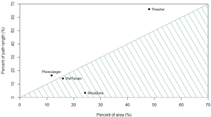
5.5. Figure of Relation between Percentage Cover of Ecological Classes in the Study Area and Percental Length of Walking Route . . . 44
5.6. Maps of Research Activities of AWI on Herschel Island . . . 46
5.7. Visual Assessment of Trail Inventory at the Beach, 2015 . . . 47
5.8. Visual Assessment of Trail Inventory at the Ice Houses, 2015 . . . 48
5.9. Radarchart of Category Counts . . . 51
5.10. Radarchart of Key Term Counts . . . 51
6.1. Photographs of Researchers and Cruise Ship Visitors to Herschel Island . . 57
6.2. Bar Charts of the Number of Visitors of Northwest Territories, the Beaufort Sea region and the Yukon Territory . . . 64
6.3. Photographs of Aircraft Travel Modalities to Herschel Island . . . 65
6.4. Photograph Vessels in of Pauline Cove . . . 66
List of Tables
3.1. Visitor Groups on Herschel Island Derived from the Cruise Ship Monitor- ing Program. . . 30 4.1. Allocated Categories to the Distinct Management Goals . . . 38 4.2. Key Terms of the Management Plan and Their Regarding Topics . . . 39 A.1. Key Goals of Herschel Island Management Plans and UNESCO Guideline . IV A.2. Plant Species, Vegetation Classes and Ecological Classes on Herschel Island XII
List of Abbreviations
AWI Alfred Wegener Institute Helmholtz Centre for Polar and Marine Research
LCT Last Chance Tourism
VT Vegetation Type
UNESCO United Nations Educational Scientific and Cultural Organisation
Convention Convention Concerning the Protection of the World’s Cultural and Natural Heritage
IFA Inuvialuit Final Agreement IGC Inuvialuit Game Council ISR Inuvialuit Settlement Region IRC Inuvialuit Regional Corporation ILC Inuvialuit Land Corporation
IDC Inuvialuit Development Corporation IIC Inuvialuit Investment Corporation ICC Inuvialuit Community Corporation WMAC Wildlife Management Advisory Council HTC Hunters and Trappers Committee
Abstract
With rising global tourism demand for wilderness and pristine habitats, the evaluation of anthropogenic impacts on the environment and preservation efforts has become more and more important. This study focuses on the Territorial Park Herschel Island Qikiqtaruk in the western Canadian Arctic, which has been on the tentative list for becoming a cultural and natural World Heritage Site since 2004. The study was conducted to determine the potential impacts of a designation in terms of visitor development and trampling distur- bances.
A thorough literature review suggested a likely increase of tourist numbers after the grant- ing of the World Heritage Status. In this thesis several visitor groups to Herschel Is- land were included, with a special focus on two main groups: cruise ship visitors and researchers, which make the bulk part of visitors to the territorial park. Park rangers and researchers helped to delineate trails commonly used by cruise ship visitors. GPS and DGPS datasets collected by researchers over the 2014-2017 period were used to show areas frequently visited for research activities.
In general, impacts from anthropogenic trampling directly result from the intensity of trampling but also vary substantially depending on the condition of the vegetation com- position. The study identified two ecological classes overwhelmingly impacted by cruise ship visitors and where trail development might occur in the future. The paths used by re- searchers are more dispersed and the resulting light but steady trampling was also shown to result in vegetation alteration.
Abstract
The impact of visitor disturbance on permafrost could not be evaluated directly on site, but a thorough literature review has shown a strong interrelationship between vegetation disturbances, trampling and permafrost thaw.
In conclusion, this thesis formulated and discussed several recommendations for Her- schel Island Qikiqtaruk Territorial Park to mitigate effects of visitor impacts on vegetation, which are likely to increase with a rising number of visitors.
1. Introduction
All around the globe people crave to visit more of the world. Remarkable and remote places are particularly appealing to many travelers (Lemelin, Dawson, Stewart, Maher, and Lueck, 2010; Hall and Saarinen, 2010; Stewart, Howell, Draper, Yackel, and Tivy, 2009). Indeed, the overall amount of travelers rose by 7% in 2017 (UNWTO, 2018). This is directly related to the increasing availability of time and income for leisure activities (Stewart, Espiner, Liggett, and Taylor, 2017; Stewart et al., 2009). Thereof cultural and natural World Heritage Sites, designated by the United Nations Educational Scientific and Cultural Organisation (UNESCO) are often chosen as visiting destinations (Frey and Steiner, 2011; Meskell, 2013;
Poria, Reichel, and Cohen, 2013; Ryan and Silvanto, 2010; Jha, 2005; Conradin, Engesser, and Wiesmann, 2015; Reinius and Fredman, 2007). The designation as World Heritage Site has been known to be a”[…] confirmation that the area is beautiful and worth seeing”
(Reinius and Fredman, 2007, p. 10, para. 1).
Besides these noteworthy and designated sites the interest in unique, wilderness land- scapes is on a steady rise (Tolvanen and Kangas, 2016; Reinius and Fredman, 2007). These places are expected to be as untouched as possible and simultaneously offer many options for leisure activities as hiking and camping (Lemelin et al., 2010; Tolvanen and Kangas, 2016). More and more people want to become explorers in their vacation and experience new adventures (Dawson et al., 2011). The Arctic is a region that encapsulates many of these aspirations. One option to explore this region is given by cruise ship operators (Blankholm, 2009; Dawson et al., 2011). Thus shipping activity in the Arctic is growing (Lasserre and Tˆetu, 2015; Stewart, Draper, and Johnston, 2005) and the ocean has become
1. Introduction
one of the major developing areas of the tourism industry (Stewart et al., 2009; Stewart and Draper, 2006).
But tourism in these last wilderness regions also has its downsides. At some sites indige- nous people suffer from visitor presence (Romaine and Gorenflo, 2017) and often nature does so as well (Forbes, Ebersole, and Strandberg, 2001; Tolvanen and Kangas, 2016; Stew- art et al., 2005). 80% of the Arctic is supposed to be influenced by human activity in 2050 (Blankholm, 2009) and it is already known, that tourism activities lead to vegetation alter- ation (Forbes et al., 2001; Tolvanen and Kangas, 2016; Campbell, Claridge, and Balks, 1994).
Several studies have shown that human impacts are related to type, time and intensity of use, as well as to the condition of the ecosystem (Forbes et al., 2001; Tolvanen and Kangas, 2016; Rausch and Kershaw, 2007; Walker and Walker, 1991). For example, processes of dis- turbance and alteration differ enormously between the Tropics and Alps (O’Neill, Balks, and L´opez-Mart´ınez, 2015; O’Neill, Balks, and L´opez-Mart´ınez, 2013; Ballantyne and Pick- ering, 2015; Stewart et al., 2017).
In recent years, Herschel Island Qikiqtaruk, a small island in the western Canadian Arctic, has become a favorite destination for several visitor groups. Since 2002 cruise ship visitors arrived on the island (Yukon Government, 2006; Yukon Government, 2018a). In addition, the Territorial Park is on the Canadian candidate list to become a cultural and natural World Heritage Site since 2004 (UNESCO World Heritage Centre, 2004). Besides pristine, Arctic wilderness, the island is characterized by a long settlement tradition (Burn, 2012).
Therefore it is of outstanding universal value to humankind, which is required for the designation as World Heritage Site (UNESCO World Heritage Centre, 2004).
In the context of this thesis I will evaluate impacts for Herschel Island Qikiqtaruk Terri- torial Park that might result from the designation as World Heritage Site. A special focus will be set on visitors and management aspects. Simultaneously I will analyze the tram- pling impact on vegetation and permafrost from different visitor groups. This approach is meant to crystallize some of the main issues facing the park over the years to come. To support my approach, a comprehensive literature review of impacts and their mitigation
in places already undergoing such shifts will be the main part of this study. I will adress my findings in the light of ongoing climate change in the area. Climate change alone sets a high pressure on Arctic environments and might be directly and indirectly fortified by tourism development in the region (Dawson et al., 2011).
2. Aim of the Thesis
The overall aim of the thesis is to examine impacts of a potential cultural and natural World Heritage Status of Herschel Island Qikiqtaruk Territorial Park and impacts from visitor alteration associated with the UNESCO designation.
To achieve this aim, I asked four questions:
1. What is the trampling impact of visitors on vegetation?
2. What is the trampling impact of visitors on permafrost?
3. How will the number of visitors develop?
4. What is the influence of UNESCO guidelines on the management of Herschel Island?
The first two questions mean to document impacts from visitors on the environment of Herschel Island. Vegetation composition is an obvious characteristic of the parks envi- ronment and I wanted to examine how and if several user groups will lead to vegetation alteration. Permafrost conditions, instead, are unapparent to observe, but also potentially impacted by visitors and play a major role in Arctic environments. Therefore possible im- pacts from visitors need to be considered. The third question emphasizes the impacts of the prospective number of visitors on the environment of Herschel Island Qikiqtaruk. I wanted to know if there are obvious trends in the development of visitors and how the designation as a World Heritage Site might influence it. The last question aims to discuss potential upcoming changes regarding management decisions. I wanted to examine the administrative requirements associated with the World Heritage designation in the frame- work of a Canadian Territorial Park and the Inuvialuit Final Agreement (IFA).
3. Background
3.1. Herschel Island Qikiqtaruk
Herschel Island Qikiqtaruk (69° 35’ 20” N, 139° 05’ 20” W) is an Arctic island with an area of 116 km2 located north of the Yukon Territory in the Canadian Beaufort Sea. It is the western most island of Canada and was formed during the last ice age. It consists out of diamicton refrozen as permafrost (Burn, 2012).
Herschel Island is located in the area of continuous permafrost (Cray and Pollard, 2018), which strongly impacts the water cycle and the type of vegetation (Burn, 2012; Myers- Smith, Forbes, et al., 2011; Wrona et al., 2016). Most parts of the island are vegetated by lowland tundra vegetation (Obu et al., 2017), which is also described as erect dwarf-shrub tundra (Wolter et al., 2016). 25% of the island are categorized as hummocky tussock tundra, whereas 32% are slightly disturbed uplands and 22% are moderately disturbed terrains (Obu et al., 2017).
The soils are primarily organic cryosols (Obu et al., 2017), which are characterized by a moderate cryoturbation, a process associated with freezing and thawing cycles (Haynes et al., 1998). The topmost layer consists of a thick, acidic organic layer (Cray and Pollard, 2018), which is determined by a relatively high nutrient availability in warmer months (Wrona et al., 2016).
3. Background
137°W 137°W
138°W 138°W
139°W 139°W
140°W 140°W
69°40'N 69°40'N
69°20'N 69°20'N
69°N 69°N
Herschel Island
0 10 20 40km
B r i t i s h
M o u n
t a i n
s
B e a
u f o
r t
S e a B e a u f o r t S e a
Ü
Figure 3.1.: Location map of the study site Herschel Island Qikiqtaruk Territorial Park, with the adjacent Yukon coast and an overview of the location at northern America.
Wildlife is abundant and diverse, with a particularly high bird diversity. Herschel Island is also a feeding ground for caribou of the Porcupine caribou herd. Muskox, Arctic fox and polar bears frequently visit the island (Burn, 2012; Yukon Government, 2006).
3.2. Ecology of Herschel Island
Herschel Island Qikiqtaruk is part of the Yukon Coastal Plain, which belongs to the South- ern Arctic ecozone. The Arctic climate leads to a continuous snow cover from September to June. This results in a short growing season with corresponding low Arctic tundra vegetation (Yukon Government, 2018a). Over the last twenty years, rapid environmental change has been measured on Herschel Island (Myers–Smith et al., 2019). The research on permanent vegetation plots evaluated an encroachment of willows and polargrasses from 1999-2009 (Cooley, Eckert, and Gordon, 2012). The key driver of ecological changes in tundra ecosystems is temperature, but hydrological responses and soil chaacteristics can delay vegetation alteration (Wrona et al., 2016).
3.2. Ecology of Herschel Island
3.2.1. Ecological Classes
Ecological classes are used to classify the landscape and are based on soil conditions and vegetation types. They are useful terrain units to study impacts of trampling. As this study will focus on possible impacts by visitors to Herschel Island Qikiqtaruk Territorial Park, it is necessary to explain the unique ecological classes of the island. These classes have been established in an important study led by Smith, Kennedy, Hargrave, and McKenna (1989). They were also used in the master thesis of Eischeid (2015) to classify the landscape using remote sensing products. Eischeid (2015) adapted some of the ecological classes for her purpose and they will be used in this thesis as well. Each of the ecological classes is associated with one or more Vegetation Types (VTs). They will be explained in the section below.
Komakuk
The ecological class Komakuk is the most common class (44%) on Herschel Island. The active layer can be up to 50 cm thick and the soil is moderately well to imperfectly drained.
The ecological class is most commonly associated with theWillow/Dryas - VetchVT, but theCottongrass/MossVT might be present as well (Smith et al., 1989).
TheWillow/Dryas - VetchVT is associated with discontinuous vegetation cover and circular patches of bare soil. Beside patches of bare soil, dense patches of Dryas integrifolia and bryophytes occur. The dominant shrub is Salix arctica, with approximately 10% cover.
Diverse forbs are also present in low percent cover, but high in frequency. This VT is probably stable and seen as a climax vegetation (Smith et al., 1989).
TheCottongrass/MossVT builds a dense vegetation cover. The most common plant isErio- phorum vaginatum (10-20% cover) and therefore some regions of the Komakuk class are referred to as ”tussock tundra”. The few established shrubs are dominated bySalix spp., but also Ericaceous shrubs are present. In a diversity of other forbs Dryas integrifolia is
3. Background
most common. Also typical is a well-developed moss layer with a cover between 20-70%.
EvenSpaghnum spp. appears sporadically and Lichens are present in small amounts. This VT seems to be a climax vegetation on Herschel Island. Still, this long established equi- librium is sensitive to disturbance due to thaw sensitive, near-surface permafrost (Smith et al., 1989).
In general, Komakuk associated with Willow/Dryas-Vetch VT seems to be less sensitive than others. It will sustain foot traffic and trail development. Other parts of Komakuk associated with Cottongrass/MossVT are sensitive to minor disturbances and should not be used for hiking (Smith et al., 1989).
Plover-Jaeger
The Plover-Jaeger class is combined out of the two different ecological classes Plover and Jaeger from Smith et al. (1989). On Herschel Island these ecological classes are difficult to distinct in the field and were therefore combined by Eischeid (2015). The combined ecolog- ical class is often found on gentle slopes and moderately eroded terrain. It is characterized by little to extensive bare ground and seen as transitional class between the ecological classes Thrasher and Komakuk. The active layer is approximately 46 cm thick and the soil pH is around 6-7.8 (Eischeid, 2015).
This ecological class is associated with the VTsWillow/Saxifrage - ColtsfootandWillow/Dryas - Vetch. Both VTs are dominated by willow species, mostlySalix spp.. TheWillow/Saxifrage - Coltsfoot VT is characterized by a continuous moss cover and frequently occurring forbs with low percent cover. Slumping in this VT is common and due to unstable vegetation and soil. Therefore, the VT is not seen as climax vegetation and often follows after pi- oneer vegetation. Compared to the Willow/Saxifrage - Coltsfoot VT, the Willow/Dryas - VetchVT is relatively stable and seen as a climax vegetation (for further description of the Willow/Dryas - VetchVT see subsection 3.2.1) (Smith et al., 1989).
3.2. Ecology of Herschel Island
In conclusion the ecological class Plover-Jaeger seems to be sensitive to disturbance where it is associated with Willow/Saxifrage - Coltsfoot VT. Foot traffic does only not have an impact during the driest time of summer. Developing trails are permanent subjects to slumping, even so ground provides attractive hiking conditions. Plover-Jaeger seems to be more stable at places associated with theWillow/Dryas - VetchVT (Smith et al., 1989;
Eischeid, 2015).
Shrub Zone
The ecological class Shrub Zone has been added by Eischeid (2015). It is still new and not as extensive described as the ecological classes of Smith et al. (1989). Soil characteristics and associated VTs are still undefined. Nevertheless, the ecological class is supposed to be associated with the correspondent, also newly added Shrub Zone VT. So far, it is character- ized by high, dense shrubs, mostlySalix richardsonii. Other species found in this ecological class areSalix arctica,Salix reticulata,Equesitum sp. andPetasites frigidus.
In general this ecological class is supposed to be linked to flooded plains, but often appears drier and less associated with hydrophilic plants. The active layer is <59 cm deep and carbon and nitrogen stocks in the soil are highest in this ecological class. Patches of bare ground seem to be rare (Eischeid, 2015).
Thrasher
The ecological class Thrasher is characterized by mass movement erosion and extremely unstable slopes. Its active layer is relatively deep (up to 80 cm). The soil pH is slightly basic (7.2-7.8) and the soils are well to moderately drained (Smith et al., 1989).
The associated VTs are affected by the occurring instability. Most common is the Arctic Willow/Lupine - LousewortVT complemented by theGrass/Chamomile - Wormwood VT at more stable patches. TheArctic Willow/Lupine - LousewortVT is dominated bySalix arctica
3. Background
(15-50%) andSalix reticulata(1-20%), in a prostrate layer. The forb layer underneath is ex- tremely robust and dominated byDryas integrifoliaandLupinus arcticus. A well developed moss cover is present between forbs and willows. Due to the unstable soil underneath the vegetation is under steady change. It likely develops into theWillow/Saxifrage - Coltsfoot VT (see subsection 3.2.1) (Smith et al., 1989).
TheGrass/Chamomile - WormwoodVT is also often present after erosional incidents with high percentage of exposed soils. The VT is dominated byGramineae and non-vegetated ground is still a present feature. The vegetation is seen as an early successional type, which will change as soon as stable conditions develop (Smith et al., 1989).
In general this ecological class should be avoided for any infrastructure development due to its instability. If there were any disturbances due to hiking or exploration, the resulting impacts would be still less than the occurring natural erosion (Smith et al., 1989).
Wet Terrain
The Wet Terrain ecological class has also been added by Eischeid (2015). It is supposed to describe areas close to creeks, that are flooded on a regular basis. Due to the flooding, new material might be deposited and a thick active layer (approximately 50 cm) forms.
Most common plant species arePetasites frigidus andEquesitum spp.. Although different plants might dominate, the ecological class usually is associated with theWillow/Saxifrage - Coltsfoot VT (see subsection 3.2.1) (Eischeid, 2015).
Orca
The Orca ecological class describes a few large alluvial fans on Herschel Island. They ac- count for≈1% of the area and include all forms of alluvium on the island. Active deposition
3.2. Ecology of Herschel Island
takes place and the ecological class lacks the typical micro-hummocky surface (Smith et al., 1989).
The associated VT is theSedge-GrassVT. It is characterized by a permafrost table<50 cm below the surface and dominated byCarex aquatilis(15-50% cover). In a few cases other grasses or sedges thanCarex aquatilisdominate (Smith et al., 1989).
In general the Orca ecological class is characterized by smooth and occasionally wet sur- faces. The soils are sensitive to hiking disturbances. One of the large alluvial fans on Herschel Island begins behind the settlement at Pauline Cove and surround the area of the whalers and Inuvialuit graves (see figure 5.4, p.43) (Smith et al., 1989).
3.2.2. Soil
The soils on Herschel Island are classified in the Canadian system of soil classification.
Widely organic cryosols dominate the island’s surface. Most typical subtypes are turbic cryosols and static cryosols (Obu et al., 2017). Turbic cryosols show distinct features of cry- oturbation and develop into mineral soils. Permafrost can be found within 2 m below the surface (Haynes et al., 1998). Static cryosols usually develop from coarse-textured mineral material or at recently disturbed sites. They are defined by the absence of cryoturbation.
The organic layer may be less than 40 cm thick and permafrost exists not more than 1 m below the surface (Haynes et al., 1998).
Permafrost landscapes in general are environments which often accumulate organic matter at the surface (Obu et al., 2017). They represent 26% of terrestrial soil ecosystems and recent research suggests that microbial life persists within the permafrost, which might have an important impact on global biogeochemical processes (Steven, L´eveill´e, Pollard, and Whyte, 2006).
Especially in boreal, subarctic and arctic landscapes, soil characteristics like nutrient avail- ability, water drainage and mechanical properties determine the vegetation growth and
3. Background
Vegetation Ecosystem disturbances
Human activity Animals
Thermokarst Thaw depth
(active layer depth) Soil temperature
Atmospheric heating
Evapotranspiration
Surface albedo Microbial activity
Soil nutrient
availability Summ
er Winter
Figure 3.2.: Flowchart of the soil and vegetation interaction derived from Wrona et al.
(2016) and slightly rearranged. Red arrows indicate positive relationships (e.g.
more vegetation leads to higher soil temperatures in winter). Blue arrows in- dicate negative relationships (e.g. more vegetation leads to lower soil tempera- tures in summer). Black arrows indicate strong linkage and influence between the characteristics.
composition (Hermanutz, 2016; Wolter et al., 2016). Due to permafrost and machanical conditions, the soil regulates the water ability for plants with an inverse relationship be- tween the retaining availability of water of the soil and the access of plants to it (Her- manutz, 2016). Therefore changes in microtopography can alter vegetation composition and active layer depth. Soil characteristics influence the vegetation pattern and so does the vegeration on soils (Wolter et al., 2016).
3.3. Structure of Administration
Herschel Island Qikiqtaruk has become a Yukon Territorial Park on July 30th, 1987 (Yukon Government, 2006; Indian and Northern Affairs Canada, 1984) and was proposed for nom-
3.3. Structure of Administration
ination as World Heritage Site in 2004 (Burn, 2012; Yukon Government, 2018a; UNESCO World Heritage Centre, 2004). Since the establishment of the territorial park, it is man- aged by the Yukon Territory Government and co-managed with the Inuvialuit. It is part of the Inuvialuit Settlement Region (ISR) and falls under the Inuvialuit Final Agreement (IFA) (Indian and Northern Affairs Canada, 1984). This territorial park has to be managed in the same manner as a national park (Indian and Northern Affairs Canada, 1984; Yukon Gov- ernment, 2006; Yukon Government, 2018a). The park consists of two zones, the wilderness territorial park and the historic territorial park. The historic territorial park contains the lands adjacent to Pauline Cove, whereas the wilderness territorial park includes the rest of the island (Burn, 2012).
3.3.1. Inuvialuit Final Agreement
The Inuvialuit Final Agreement (IFA) is an agreement between the Committee for Origi- nal Peoples Entitlement, which represents the Inuvaluit of the Inuvialuit Settlement Re- gion (ISR), and the Government of Canada represented by the minister of Indian Affairs and Northern Development. This agreement aims to preserve the cultural identity and values of Inuvialuit in a changing society. By law, Inuvialuit are equal and meaningful participants of the development of the far north of Canada. Besides rights of indigenous people, the agreement means to protect Arctic wildlife, environment and biological pro- ductivity (Indian and Northern Affairs Canada, 1984). Therefore” […] the Inuvialuit cede, release, surrender and convey all their aboriginal claims, rights, title and interests, whatever they may be, in and to the Nothwest Territories and the Yukon Territory” (Indian and North- ern Affairs Canada, 1984, p. 5, para. 3.5).
To manage this region for further development, different corporate structures were es- tablished. These structures are meant to be beneficial for Inuvialuit and care for their rights. The Inuvialuit Regional Corporation (IRC) is a corporation without any share cap- ital, which receives the settlement lands and financial compensation at first. The received
3. Background
IRC
ILC IDC IIC
Inuvialuit Trust
ICCs
owns 100% of non-voting shares, responsible for financial transfers owns settlement
lands
own financial compensations
Inuvialuk
control
financial transfer
Figure 3.3.: This flowchart shows the organization of the Inuvialuit Regional Corporation (IRC). ILC = Inuvialuit Land Corporation, IDC = Inuvialuit Development Cor- poration, IIC = Inuvialuit Investment Corporation, ICC = Inuvialuit Commu- nity Corporation. Source: own illustration.
lands are owned by the Inuvialuit Land Corporation (ILC). Two different corporations, the Inuvialuit Development Corporation (IDC) and the Inuvialuit Investment Corporation (IIC) receive financial compensation from IRC. The IDC is responsible for industrial develop- ment in the region. The IIC is responsible to invest the received money into portfolio securities. 100% of non-voting shares belong to the Inuvialuit Trust. The Inuvialuit Trust manages financial transfers to each individual Inuvialuk. All in all the IRC is controlled by the Inuvialuit Community Corporations (ICCs), which consists of members of Inuvialuit communities in the ISR (for further explanation see figure 3.3) (Yukon Government, 2006).
Furthermore, to fulfill the harvest rights of the Inuvialuit and to manage wildlife properly, different committees were established. The most relevant committee is the Wildlife Man- agement Advisory Council (WMAC). WMAC has six members, one member is part of the Canadian Government, two members are from the North West Territories Government and
3.3. Structure of Administration
three members have to be Inuvialuit. The entrusted tasks of WMAC are determination and recommendation of harvest quotas, to propose review and advise to the Canadian Govern- ment on any aspects regarding wildlife and preparation of a wildlife conservation and man- agement plan for the ISR. WMAC is supported by different other committees and councils as the Fisheries Joint Management Committee, the Inuvialuit Game Council (IGC), the In- uvialuit Hunters and Trappers Committees (HTCs) and the Research Advisory Council.
These committees and councils fulfill tasks to acknowledge Inuvialuit rights and propose WMAC with necessary information on the development of wildlife. Each ICC therefore has an associated HTC (Indian and Northern Affairs Canada, 1984). The closest HTC to Herschel Island Qikiqtaruk is the Aklavik Hunters and Trappers Committee (Yukon Gov- ernment, 2006).
3.3.2. Management Plan
As a result of the IFA, Herschel Island Qikiqtaruk Territorial Park got its first management plan in 1987 (Yukon Government, 2006). It has been revised in 1991, 2006 and 2018. The first management plan was prepared by a joint committee, which was composed of members of the government and Inuvialuit. The revised versions are also cooperative achievements between WMAC, Aklavik HTC, IGC and governmental parties (Yukon Government, 2006;
Yukon Government, 2018a). The last revision of the management plan took place in 2018 while this thesis was written. Therefore the management plan of 2006 and the management plan of 2018 are examined and will be discussed later.
The main focus of the management plan of 2006 is to ”conserve the islands natural and heritage resources, while respecting Inuvialuit rights” (Yukon Government, 2006, p. 2, para.
2). It focuses on four main categories, each with its distinctive management recommenda- tions:
1. ecosystems, biodiversity and wildlife 2. heritage and culture
3. Background
3. visitor use
4. economic benefits
The vision of the management plan of 2018 is that
”Herschel Island-Qikiqtaruk is a place of traditional use, connection to the land, and where knowledge is shared with future generations. As a unique Arctic island, Herschel Island Qikiqtaruk Territorial Park has a special role as a gathering place where Inuvialuit welcome and benefit from visitors experiencing, learning about and celebrating the island and its cultural and natural history. Those who manage and take care of the island work together to fulfill the Elders’ vision of Qikiqtaruk as a park to protect and sustain the ecological integrity and heritage values for generations to come” (Yukon Government, 2018a, p. 6, para. 1).
It focuses on the same four categories as the management plan from 2006 for the imple- mentation of the vision.
3.4. Tourism
”The commercial organization and operation of holidays and visits to places of interest.” (https://en.oxforddictionaries.com/definition/tourism; 11.06.2019;
18:36 Uhr)
3.4.1. Last Chance Tourism
The global tourism demand is on a steady rise (Stewart et al., 2017; Stewart et al., 2009;
UNWTO, 2018) and most visitors like to visit pristine and wild places (Lemelin et al., 2010;
Hall and Saarinen, 2010; Stewart et al., 2009). There is an increasing thirst to experience
3.4. Tourism
changing and endangered landscapes, animals and plants before they finally vanish. This kind of tourism is called Last Chance Tourism (LCT) (Lemelin et al., 2010).
In general LCT is seen as a double-edged sword for the traveled regions (Lemelin et al., 2010; Dawson et al., 2011). An increase in tourism activity will add stress to already im- pacted and threatened systems (Lemelin et al., 2010) and is not only added locally. The complex global interaction of leisure travel to distant destinations, like CO2 emissions, building of infrastructure and production of waste, sets stress to the whole environment (Dawson et al., 2011). On the other hand travelers might act as environmental ambassadors against climate change (Dawson et al., 2011). As the Arctic is known as the world’s last great wilderness, for its scenery landscape and the endangered polar bears, it has become a favorite destination for last chance tourists (Lemelin et al., 2010; Stewart et al., 2005).
3.4.2. Arctic Tourism
Tourism in the Arctic has historically developed from the intention to find the Northwest Passage. Nowadays, people like the perception of being explorers and adventurers visiting unseen places (Dawson et al., 2011). As most of the Arctic is characterized by remoteness and pristine wilderness, the infrastructure for tourism is present, but less developed than in other touristic regions (Lasserre and Tˆetu, 2015). Commonly, Arctic tourism is charac- terized by its difficulty to access sites of interest: geographical as well as financial; due to the fragile environment where it takes place; its little developed infrastructure and a high seasonality (Hall and Saarinen, 2010).
Nevertheless, because of its substantial economic income, even compared to energy and mineral exploitation, tourism is developing as a major industry in the Arctic. It is already a significant part of Yukon Territories economy and of growing interest to northern gov- ernments (Hall and Saarinen, 2010).
3. Background
Figure 3.4.: This shows the MS Hanseatic, an expedition-style cruise ship vessel operated by Hapag Lloyd, in Thetis Bay opposite the main camp on Herschel Island Qik- iqtaruk. Source: Researcher of AWI, 2012
As the ocean is the fastest increasing global tourism sector (Stewart et al., 2009), the amount of cruise ship tours has grown steadily (Stewart et al., 2009; Stewart and Draper, 2006).
Cruise ship operators serve most of the scenic landscape and offer tours to remote places like Antarctica and the Arctic (Lasserre and Tˆetu, 2015; Blankholm, 2009). In 1984 the first cruise ship MV Explorer navigated through the Northwest Passage (Stewart et al., 2009). Since then the amount of cruise ships in the Arctic continually increased and became scheduled on a regular basis (Lasserre and Tˆetu, 2015; Hall and Saarinen, 2010).
Still, only 11% of the Arctic waters are charted for shipping (Lasserre and Tˆetu, 2015) and the season is narrowed down by ice break up in July and refreezing in October (Stewart et al., 2009; de La Barre et al., 2016). Even though, the extent of polar ice has decreased (Blankholm, 2009), cruise ship operators are highly dependent on weather and ice condi- tions (personal communication with R.Gordon; Stewart et al., 2009) as well as on seasonal variations (Hall and Saarinen, 2010). If ice coverage melted further the Canadian Arctic might become a major cruise ship highway (Lasserre and Tˆetu, 2015).
3.4. Tourism
In addition, the tourism industry in the Arctic is highly fragmented (Landorf, 2009). As the Arctic is a region managed by eight different countries (Canada, Denmark, Finland, Iceland, Norway, Russia, Sweden, USA), each country developed its own tourism man- agement strategy (Hall and Saarinen, 2010). Until now, no international management and monitoring strategies are present (Stewart et al., 2009) and collecting data from all coun- tries is difficult (Stewart et al., 2005). The Canadian Arctic still misses a holistic approach to measure tourism activity. Observation is mostly scattered across many organizations and shipping is not an integral part of observation (de La Barre et al., 2016). Due to this lack of strong regulations and missing infrastructure, many tour operators are not likely to expand in Canada (Lasserre and Tˆetu, 2015).
Still, the modern possibilities for visits are diverse and range from flights and snowmobile adventures, to cruise ship tours and individual hikes.
3.4.3. Tourism on Herschel Island
The first settlement on Herschel Island Qikiqtaruk dates back to 1200 AD. It has served as part of an international trading route between indigenous people from the western Cana- dian Arctic and Russia or China. Before establishing Herschel Island Qikiqtaruk Territorial Park under the IFA, the island has been a harbor for whalers and a trading point of arc- tic fox and seal fur. Until the 20th century the settlement was continuously inhabited by Inuvialuit and other user groups (see figure 3.5, p.32) (Burn, 2012).
Since the establishment of the Herschel Island Qikiqtaruk Territorial Park the amount of visitors is monitored (see figure 5.1, p.40). The monitoring program breaks down visitors in five visitor groups (see table 3.1 for further description, p.30).
As one of the main goals of the park’s establishment is to maintain the wilderness char- acteristics of Herschel Island Qikiqtaruk, visitors need to obtain a park permit to visit the
3. Background
island. The only excepted group are Inuvialuit/Inupiat visitors. All other visitors are in- formed before their visit and guided and supervised on the island by park rangers (Yukon Government, 2006; Yukon Government, 2018a).
Table 3.1.: Summary of visitor profile categories to Herschel Island Qikiqtaruk Territorial Park. The visitor groups are derived from the Herschel Island cruise ship mon- itoring program and mirror the actual user groups of the island.
Visitor group Description
Cruise ship visitors Persons arriving by large cruise ship vessels. The large ves- sels will anchor close to the island and groups of 15-20 peo- ple will be shipped to the island by zodiacs. In the years 2005-2016 no cruise ship visitors stayed over night on Her- schel island.
Inuvialuit/Inupiat Inuvialuit/Inupiat visitors are members of indigenous com- munities. They often visit the island for traditional use as hunting and fishing. Some conduct Elder-Youth-programs to impart traditional knowledge.
Governmental visitors Persons from the park administration of Yukon. They visit the island for different purposes, sometimes to monitor the conditions of the natural and cultural heritage and/or for training purposes.
Tourists The visitor group tourists is a compilation of all persons traveling to the island not fitting in one of the other groups.
Those visitors often arrive by small sailing vessels in the summer or by snowmobile in winter. Only a few attain the island via helicopter.
3.5. UNESCO and World Heritage
Researchers With the establishment of the park, the monitoring and ex- ploration of the environment of Herschel Island for a bet- ter understanding of the ecological interrelations became a key goal. This focus is fulfilled by diverse international cooperation with research institutes.
3.5. UNESCO and World Heritage
The United Nations Educational Scientific and Cultural Organisation (UNESCO) was founded in 1944 in the context of World War II by the United Nations (Meskell, 2013; Ryan and Silvanto, 2010). This internationally recognized organization passed the Convention Con- cerning the Protection of the World’s Cultural and Natural Heritage (Convention) in 1974.
The Convention aims to safeguard natural and cultural heritage sites of outstanding uni- versal value for mankind (UNESCO, 1972). UNESCO still remains the most important in- ternational organization in protecting heritage sites with 193 nations that have signed and ratified the Convention (Meskell, 2013; Conradin and Hammer, 2016).
The Convention allows participating nations to nominate sites of historic, cultural or nat- ural value for humankind in their country (UNESCO, 1972). Afterwards a committee and advisory bodies evaluate if the site is worth the inscription on the World Heritage List (UNESCO, 1972). With inscription sites gain a legal status for protection (Ryan and Sil- vanto, 2010). Contingent on the nation the legal status can be helpful for sites to gain a broader acceptance and relevant assistance in conservation issues (Frey and Steiner, 2011;
Jha, 2005).
UNESCO expects each inscribed site to have a management plan. Depending on actual management sites might have to implement additional strategies for safeguarding their heritage after inscription (UNESCO, 1972).
3. Background
1200
First Settlement at Pauline Cove,
inhabited by indigenous people 1500
Settlement at Avadlek Spit, small community which was abandoned
soon
1893-1930s
A stationary mission was established and served with small interruptions
1890-1912
Whalemen of up to 15 vessels in one year overwintered on the island
1903-1964
Royal North-West Mounted Police (RNWMP) was stationed
1912-1937
Fur trading point in summer, with HBC post (1915) until prices of
arctic fox fur dropped
1950s-1960s
Seasonal seal hunting on the island
1891
First ice house was build by whalers 1837
Thomas Simpson and Peter Dease travelled along the coast to map the area
1851
HMS Enterprise with Cpt. Collinson visited the island twice
1905
Roald Amundsen passed by in the search of the North West Passage
1987 until present Establishment of the Herschel Island
Territorial Park under the Inuvialuit Final Agreement
1912-1918
Canadian Arctic Expedition, with the order to search for land and map the coast
1927-1937
Erling Porsild surveyed the vegetation of northern Canada, he stopped over on
Herschel island several times 1950s
Several field parties of the grographical brand of the Department of Mindes and Technical Resources explored Herschel island
1990-1993
A study on the oral history of Herschel island together with Elders was conducted
2007-2009
The island has been a focus research location for ecosystem studies in the
International Polar Year
Figure 3.5.: Time line of inhabitants and visitors to Herschel Island Qikiqtaruk derived from Burn (2012). This abbreviated version of mentioned inhabitants and visitors contains the presumably most influential inhabitants and visits to Herschel Is- land Qikiqtaruk.
3.5. UNESCO and World Heritage
Canada is part of UNESCO since November 4th, 1946 and ratified the Convention on July 23rd, 1976. The country has been four times a member of the World Heritage Committee and exhibits 19 World Heritage Sites (UNESCO World Heritage Centre, 2004). Since 2004, Herschel Island Qikiqtaruk is inscribed on the tentative list of UNESCO, together with the Canadian National Parks Ivvavik and Vuntut, to become a cultural and natural World Heritage Site. The three inscribed parks account for 15 500 km2 of the northern Yukon Coastal Plain. They preserve a broad natural and cultural heritage as part of the ISR (see subsection 3.3.1, p.23) (UNESCO World Heritage Centre, 2004).
4. Methods
This study is not based on new empirical evidence, but rather on a thorough literature review and data mining focused on cruise tourism in the Arctic, Herschel Island Qikiqtaruk Territorial Park, the World Heritage Site process and vegetation impact associated with small anthropogenic disturbances such as trampling. The conducted methods are outlined in the sections below. Several other methods and datasets were used in the early stages of this thesis but are not included in the analysis, because the results were not conclusive.
An overview of used datasets is provided in appendix A.1.
4.1. Development of Number of Visitors
The number of tourists is monitored by park rangers and the Yukon Territory Government and collated in the year-end reports of the head ranger. The collated numbers have been partly published by Yukon Parks in the Herschel Island Visitation Synopsis 2016 from C.
Eckert, the management plan of 2006, the management plan of 2018 and the ecological monitoring report of 2012. Other numbers were obtained from B. Riley from the Tourism and Culture branch of the Yukon Territory Government.
The numbers have been combined with LibreOffice Calc Version 5.3.7.2 (The Document Foundation, 2000-2017) and were analyzed with R Version 5.3.5 (R Core Team, 2019) in the user interface R Studio Version 1.2.1335 (RStudio, 2009-2019). The bar plot() command has been used for all bar charts (see figure 5.1, p.40; figure 5.2, p.42; figure 5.3, p.42).
4.2. Vegetation Analysis
4.2. Vegetation Analysis
To analyze the impact of anthropogenic trampling on vegetation, it was decided to focus on the impact of the two main visitor groups: researchers and cruise ship visitors. The places visited by each group were collected, delineated and visualized in ArcMap Version 10.6 (ESRI Inc., 2018) together with the ecological classes derived from Eischeid (2015). To give a better insight of the environment on Herschel Island photographs of trails together with satellite images of surrounding areas were adapted to contextualize the visitor paths.
4.2.1. Walking Trail for Cruise Ship Tourists and Impact on Vegetation
To evaluate the sites most impacted by cruise ship visitors the usual walking trail for visits on Herschel Island was plotted with help of park rangers and researchers, who support visitor guidance. In short, the park rangers and researchers were asked to recollect the paths usually taken by cruise ship visitors when they visit the island. This path is mainly used for visitor guidance around the island and goes through most cultural heritage sites located around the Pauline Cove area. This recollected path is the best indication of paths taken by visitors but it does not mean that all visitors adhered strictly to the rules and some of them may have chosen a path of their own.
As most tourists go through the same route, the map of Eischeid (2015) with the ecolog- ical classes was used for a relation analysis between walking route length and occurring ecological classes. The examined area was clipped via ”Clip-Tool” of ArcMap for the study area. The cumulative area of each ecological class in the study area was measured with the spatial analyst tool ”Zonal-Geometry-as-Table” in order to identify ecological classes that are preferentially impacted by visitors. In a second step, the intersection of paths and the polygon feature of the ecological classes was identified and the length with geome- try processing calculated. The derived data was plotted and the sector of potential over
4. Methods
use marked (see figure 5.5, p.44). Afterwards the impact of tourism, especially trampling on vegetation, was estimated through literature reviews, personal communication with rangers of Herschel Island Qikiqtaruk and the known condition of the ecological classes published in the literature.
4.2.2. Hot Spot Analysis of Research Impact on Vegetation
To analyze the impacted sites by researchers of Alfred Wegener Institute Helmholtz Cen- tre for Polar and Marine Research (AWI) a Hot Spot Analysis on the GPS and DGPS data from 2014 to 2017 was conducted. Hot Spot Analysis are used to visualize statistically significant spatial clusters by using the appearance of neighbors in a predefined distance to a distinct feature. Features which are associated with high values and surrounded by other features with high values will be determined as hot spots, while features with low values, surrounded by other features with low values will be determined as cold spots. In this study identified hot spots represent places, which are significantly more frequented by researchers than other places and identified cold spots represent places, which are signifi- cantly less frequented by researchers than other places. The rest of the places researchers go through are marked as not significant. They are neither significantly more nor less visited than other places (ESRI Inc., 2019).
The Hot Spot Analysis was conducted with ArcMap Version 10.6. First of all, the existing GPS and DGPS datasets were uploaded as new layers and overlaid with the Herschel Island satellite image from World View 3 of 2015. All GPS tracks were converted to points with the
”Feature-Vertices-to-Points” function. To analyze the spatial distribution all datasets were merged into one layer. Afterwards the points were integrated with the ”Data-Management- Tool” to snap close points. Via ”Spatial-Statistics-Tool” all events were collected and coinci- dent points were combined. The ”Spatial-Autocorrelation” function was used to determine the distance for neighboring points and z-score for further analysis. The following Hot Spot Analysis was run with a specified distance of 275 m and a z-score of 484. The inverse
4.3. Impact on Permafrost
distance method was chosen as calculation method. Inverse distance as method, leads to a higher influence of nearby features to target features on calculation, than features further away.
4.2.3. Additional Insight into the Environment via Photographs
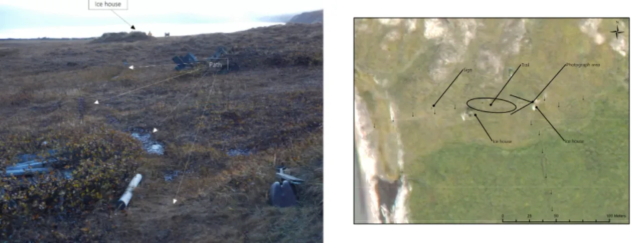
For a better insight in the local conditions of ecological classes, vegetation and environment photographs from 2015 from two impacted sites were included in this study. As there are not enough pictures with the same perspective from different years, it was not possible to conduct a visual comparison assessment, yet subjective appreciation of the pictures gives a good indication of the impacts of trampling on vegetation. The World View 3 image of 2015 was used to delineate landmarks in the landscape (see figure 5.7, p.47 and figure 5.8, p.48).
4.3. Impact on Permafrost
As the study area is located in the region of continuous permafrost (see section 3.1, p.15), hydrology is one of the most important drivers of ecosystem development and succession (Wrona et al., 2016; Walker and Walker, 1991). As vegetation relies on water supplement and nutrient avalability, which is regulated by permafrost conditions, permafrost and veg- etation are in a steady, interdependent connection in the Arctic ecosystem (Wolter et al., 2016; Wrona et al., 2016). Therefore impacts of trampling and possibly resulting changes of permafrost have to be discussed in this approach. Because of limited possibilities to study trampling impacts on Herschel Island Qikiqtaruk itself, this chapter does not offer new applied results. But rather a systematic desk-based literature review of conducted research with a focus on interaction between permafrost, trampling, anthropogenic pres- sure and vegetation alteration in the Arctic and oral information from park rangers and researchers.
4. Methods
4.4. Evaluating the Effects of UNESCO
To compare the guidelines of UNESCO and the management strategies of Herschel Island Qikiqtaruk Territorial Park, the Convention and the management plans of the park were analyzed. A systematic comparison of all management regulations of the Herschel Island Qikiqtaruk management plans from 2006 and 2018 and the Convention was performed.
The distinct regulations of each management plan were excerpted and combined by their overall intentions. Afterwards the intentions were clarified and shortened to compile a distinct list of management goals (see table A.1). Those resulting management goals were used to allocate categories regarding the question of the thesis (see table 4.1 for categories).
Each management goal could be allocated with more than one category. Therefore the overall number of counts overshoots the number of listed management goals. The counts were pictured with R Studio and the order radarchart() from the package fsmb (see figure 5.9, p.51).
Table 4.1.: This table amplifies the five categories which have been allocated on the clarified management goals
Category Description
Ecology Every management goal associated with ecology even without distinct management suggestions.
Inuvialuit/traditional This category is associated with every management goal, that broaches the issue of traditional lifestyles and Inu- vialuit rights.
Heritage All management goals dependent on heritage, culture and historic topics like the conservation of buildings and graves.
Management focus on ecology
This category counts all management goals, that are strict management suggestions on the conservation of ecological features of the park.
4.4. Evaluating the Effects of UNESCO
Management focus on visitors
This category counts all management goals, that are strict management suggestions on the practice with visitors to the island. Visitors are all people coming to the island, re- gardless of their intentions.
In a second step, a counting of key terms associated with topics of each management plan (see table 4.2 for key terms) was conducted. As the management plans differ in their num- ber of pages, the 2018 management plan was adjusted to the number of pages of the 2006 management plan, by multiplying the counts with 1.47. All counts were rounded to the next integer (see figure 5.10, p.51).
Table 4.2.: This table shows the six topics which have been associated with different key terms. These key terms have been counted in each management plan.
Topic Counted key terms
Ecology ecological, ecosystem, wildlife, conservation, natural Inuvialuit/traditional Inuvialuit, traditional, cultural, culture
Heritage heritage, historic, building
UNESCO UNESCO, world heritage
Tourism visitor, cruise ship, cruise ship visitor, ship, tourism, tourist Research research, researcher, science, scientist
To further identify potential consequences of the establishment of a World Heritage Site, a literature review of potential impacts associated with UNESCO status establishment was conducted. The output was a critical appraisal of impacts of UNESCO and World Heritage site status on different regions of the Earth.
5. Results
5.1. Development of Number of Visitors
The total number of visitors to Herschel Island Qikiqtaruk Territorial Park from 1989 - 2017 ranged from 310 up to 875 visitors per year. The conducted linear regression resulted in no developmental trend in the quantity of visitors (R2 = 0.216). In average 565 visitors arrive yearly on Herschel Island, with a standard deviation of 142 (see figure 5.1).
1989 1991 1993 1995 1997 1999 2001 2003 2005 2007 2009 2011 2013 2015 2017
Number of visitors
Year
02004006008001000
Figure 5.1.: The figure shows a bar chart of the overall number of visitors in the years from 1989 to 2017
The analyzed number of visitors of the different visitor groups do not show any statistically significant trend. Figure 5.2 demonstrates that many visitors are part of the cruise ship
5.2. Vegetation Analysis
visitor category and that they seem to have increased over the last years. Therefore it was decided to focus on this visitor group in the following analysis. Likewise, figure 5.3 shows that researchers (apart from the not cited rangers) spend many days on Herschel Island.
They also seem to have an increasing trend and it was decided to focus on this visitor group as second part of the analysis.
5.2. Vegetation Analysis
5.2.1. Walking Trail of Cruise Ship Visitors
Map 5.4a shows the walking route close to Pauline Cove, around the settlement and to- wards most of the sightseeing places on Herschel Island Qikiqtaruk. The complete walk- ing route has a length of 2415.75 m. It passes different vegetation types and four ecological classes (see figure 5.4b). Most of the cruise ship visitors are guided along this walking trail on their visit. The beginning and ending is marked with a red dot, close to the settlement, at the tip point of the coast. Usually, cruise ship visitors land there in small groups by zo- diacs. While walking north towards the ice houses the visitors are guided along the coast.
Then turn inwards, to the east, up the hills, where the ice houses are located. From there an inland trail leads back to the Mission house along the whalers’ graves. Back at the Mis- sion house nowadays visitors are lead along the coast back to the settlement to mitigate trampling impacts.
5. Results
2005 2006 2007 2008 2009 2010 2011 2012 2013 2014 2015 2016
cruise ship visitors Inuvialuit/Inupiat governmental visitors tourists researchers
Year Visitors 0200400600800
Figure 5.2.: The figure shows a stacked bar chart of the number of visitors sorted in five different categories (cruise ship visitors (light green), Inuvialuit/Inupiat visitors (medium sea green), governmental visitors (lime green), tourists (green) and researchers (dark green)) of Herschel Island in the last 10 years.
2005 2006 2007 2008 2009 2010 2011 2012 2013 2014 2015 2016
cruise ship visitors Inuvialuit/Inupiat governmental visitors tourists researchers
Year visited days 0500100015002000
Figure 5.3.: The figure shows a stacked bar chart of the number of days visitors stayed on Herschel Island in the last 10 years. The number of visitors is sorted in five different categories (cruise ship visitors (light green), Inuvialuit/Inupiat visitors (medium sea green), governmental visitors (lime green), tourists (green) and researchers (dark green))
5.2. Vegetation Analysis
!!!!!!!!!! !!!!!!!
!!!!!!!!!!!!!!!!!!!!!!
!!!!!!!!!!!!!!!!!!!!!!
!!!!!!!
!!
!!
!!
!!
!!
!
!!
!!
!!
!
!!!
!
!!
!!
!
!!
!!!!!!!!!!!!! !!!!!!!!!!!!!! ! ! ! ! ! ! ! ! ! ! !!!!!!!!
!
!!
Settlement Mission house
Ice house Whaler's graves
.
Ü
010020050Meters!Landing point Study area
Walking track
!Walking points !!!!!!!!!! !!!!!!!!!!!!!!!!!!!!!!!!!!!!!!!!!!!!!!!!!!!!!!!!!!!!!!!!!!!!!!!!!!!!!!!!!!!!!!!!!!!!!!!!!!!!!!!!!!!! !!!!!!!!!!!!!! ! ! ! ! ! ! ! ! ! ! !!!!!!!!
!!!
Ü
010020050Meters!Landing point Ecological classes Plover-Jaeger Shrub Zone Thrasher Water Wet Terrain
Study area
Walking track
!Walking points (a)Themapshowsthemainlyusedwalkingrouteandlanding pointforcruiseshiptouristsonHerschelIsland.Itwasdrawn frommemorybyH.Lantuit,supplementedwithvisiblepaths ofsatelliteimageryandrevisedbyR.Gordon(SeniorPark Ranger)
(b)Themapshowsthemainlyusedwalkingrouteandlanding pointforcruiseshiptouristsonHerschelIsland(seemap5.4a). Additionally,ecologicalclasses(Plover-Jaeger(lightgreen), ShrubZone(lightpurple),Thrasher(lightorange),Water(light blue)andWetTerrain(darkgreen))ofHerschelIslandare shownasasecondlayer,tovisualizeimpactedclassesbytram- plingofcruiseshipvisitors. Figure5.4.:MapsoftheWalkingRouteofCruiseShipVisitorsonHerschelIsland