M. Vernet1 , W. Geibert2 , M. Hoppema2 , P. J. Brown3 , C. Haas2 , H. H. Hellmer2 , W. Jokat2 , L. Jullion4 , M. Mazloff1 , D. C. E. Bakker5 , J. A. Brearley6 , P. Croot7 , T. Hattermann2,8 , J. Hauck2 , C.‐D. Hillenbrand6 , C. J. M. Hoppe2 , O. Huhn9 , B. P. Koch2 , O. J. Lechtenfeld10 , M. P. Meredith6 , A. C. Naveira Garabato11 , E.‐M. Nöthig2 , I. Peeken2 , M. M. Rutgers van der Loeff2 , S. Schmidtko12 , M. Schröder2 , V. H. Strass2 , S. Torres‐Valdés2,3 , and A. Verdy1
1Scripps Institution of Oceanography, La Jolla, CA, USA,2Alfred Wegener Institute Helmholtz Centre for Polar and Marine Research, Bremerhaven, Germany,3National Oceanography Centre, Southampton, UK,4Institut Méditerranéen d'Oceanologie, Marseille, France,5Centre for Ocean and Atmospheric Sciences, School of Environmental Sciences, University of East Anglia, Norwich, UK,6British Antarctic Survey, Cambridge, UK,7Irish Centre for Research in Applied Geoscience (iCRAG@NUIG), Earth and Ocean Sciences, National University of Ireland, Galway, Ireland,8Norwegian Polar Institute, Fram Centre, Tromsø, Norway,9Institute of Environmental Physics, University of Bremen, Bremen, Germany,10Helmholtz Centre for Environmental Research, Leipzig, Germany,11National Oceanography Centre, University of Southampton, Southampton, UK,12GEOMAR Helmholtz Centre for Ocean Research, Kiel, Germany
Abstract
The Weddell Gyre (WG) is one of the main oceanographic features of the Southern Ocean south of the Antarctic Circumpolar Current which plays an influential role in global ocean circulation as well as gas exchange with the atmosphere. We review the state‐of‐the art knowledge concerning the WG from an interdisciplinary perspective, uncovering critical aspects needed to understand this system's role in shaping the future evolution of oceanic heat and carbon uptake over the next decades. The main limitations in our knowledge are related to the conditions in this extreme and remote environment, where the polar night, very low air temperatures, and presence of sea ice year‐round hamperfield and remotely sensed measurements. We highlight the importance of winter and under‐ice conditions in the southern WG, the role that new technology will play to overcome present‐day sampling limitations, the importance of the WG connectivity to the low‐latitude oceans and atmosphere, and the expected intensification of the WG circulation as the westerly winds intensify. Greater international cooperation is needed to define key sampling locations that can be visited by any research vessel in the region. Existing transects sampled since the 1980s along the Prime Meridian and along an East‐West section at ~62°S should be maintained with regularity to provide answers to the relevant questions. This approach will provide long‐term data to determine trends and will improve representation of processes for regional, Antarctic‐wide, and global modeling efforts—thereby enhancing predictions of the WG in global ocean circulation and climate.Plain Language Summary
The Weddell Gyre is one of the main oceanographic features in the ocean surrounding Antarctica, the Southern Ocean. Although located far from other continents, this polar region affects the planet through the exchange of gases between frigid ocean waters and the atmosphere, regulating oxygen and carbon dioxide farther north. Studying the Weddell Gyre is challenging, as sea ice covers the ocean surface year around, restricting access by research ships and sensing of ocean surface from satellites. New technology is now available to avoid past limitations, autonomous underwater vehicles, instrumentsflown by planes, andfloats instrumented with sea‐ice detection. Only through international collaboration can we obtain adequate data to populate environmental models and study key areas in the gyre or hot spots. In this review we identify the missing links in our knowledge of the gyre, proposing research to address those questions. Three aspects are critical to understanding the processes that drive the gyre's oceanography, ice, geology, chemistry, and biology: winter and under‐ice conditions that set the stage for the evolution of physics, ice, and biogeochemistry; exchange of water, material, and energy (or heat) with lower latitudes; and intensification of the clockwise circulation of the gyre with changes in winds.©2019. The Authors.
This is an open access article under the terms of the Creative Commons Attribution‐NonCommercial‐NoDerivs License, which permits use and distri- bution in any medium, provided the original work is properly cited, the use is non‐commercial and no modifica- tions or adaptations are made.
†W. Geibert and M. Hoppema contrib- uted equally to planning, organizing, and editing this review.
Key Points:
• Major research priorities to advance understanding of the Weddell Gyre are identified and justified against current knowledge
• Interdisciplinary approaches are needed to support system science research of the Weddell Gyre and promote collaborative projects
• Winter conditions, connectivity to lower latitudes, and intensification of the gyre are the main interdisciplinary priorities
Correspondence to:
M. Vernet, mvernet@ucsd.edu
Citation:
Vernet, M., Geibert, W., Hoppema, M., Brown, P. J., Haas, C., Hellmer, H. H., et al. (2019). The Weddell Gyre, Southern Ocean: Present knowledge and future challenges.Reviews of Geophysics,57 https://doi.org/
10.1029/2018RG000604
Received 12 APR 2018 Accepted 24 APR 2019
Accepted article online 8 MAY 2019 Published online 4 JUL 2019
, 623–708.
1. Introduction
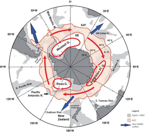
The Weddell Gyre (WG) is in many respects an unusual and extreme region, directly controlling the proper- ties of substantial parts of the global deep (200–3,000 m) and abyssal (>3,000 m) ocean and indirectly shap- ing global climate. South of the Antarctic Circumpolar Current (ACC)—the strongest current system on Earth—the WG is the largest of several coherent oceanic regions (Figure 1), spanning about 5.6 ×10⁶km2. Together with the Ross Gyre, the WG comprises the southernmost open ocean reaches on the planet (Figure 1). Extremely low sea surface temperatures and extensive sea‐ice formation are characteristics of this region. Consequently, it is a foremost location of deep and bottom water formation on the Southern Hemisphere. This region also plays an important role in regulating air‐sea exchanges and heatflow as a result of a delicate balance between upwelling of relatively warm subsurface waters and via its sea‐ice cover (Fahrbach et al., 1994; Gordon & Huber, 1990). As outlined in more detail below, this strong connection between the atmosphere, surface ocean, and deep waters makes the WG arguably a most influential oceanic region with the capability of influencing global climate on time scales of hundreds to thousands of years.
The WG is situated in the Atlantic sector of the Southern Ocean, south of 55–60°S and roughly between 60°W and 30°E (Deacon, 1979). It stretches over the Weddell abyssal plain, where the Weddell Sea is situated, and extends east into the Enderby abyssal plain (10–20°E; Figure 2). The gyre is, however, a dynamic feature, with its eastern boundary notfixed to a location; it has been suggested that it might extend as far as 70°E (Mackintosh, 1972; Y.H. Park et al., 2001). The WG is principally driven by wind forcing (see section 3.1) and steered by topography, including continental boundaries and seabed structures. In the south and west (50°W), the gyre is bordered by the Antarctic mainland and its northward extension, the Antarctic Peninsula. In the north, the boundary is formed by the frontal structure of the southern ACC, which in turn is topographically guided by the South Scotia Ridge in the west and the North Weddell Ridge in the east. In this way, the northern boundary of the gyre in the west is at about 60°S, whereas further east, it moves to about 55°S, locally extending further north into the South Sandwich Trench at about 30°W (Figure 2).
East of about 20°E, the gyre boundary takes a southward direction following the course of the ACC, steered east of the Gunnerus Ridge. Along its southern and western boundaries, the WG isflanked byfloating ice shelves, the seaward extension of the Antarctic ice sheet (depicted by the red contour in Figure 2; see section 4). They form as a result of the gravity‐drivenflow of inland ice toward the coast. Some of these ice shelves extend more than a hundred kilometers offshore, with the Filchner‐Ronne Ice Shelf, which cov- ers a portion of the southern Weddell Sea continental shelf over an area extent roughly the same size of Sweden, being the largest body offloating ice on Earth. The ocean cavities beneath ice shelves give rise to a unique environment where seawater interacts with glacial ice at depths up to over 1 km below sea level;
numerous canyons run from the continental shelf break into the abyssal plains, connecting coastal and con- tinental shelf processes to the Weddell basin. Waters deeper than 3,000 m are connected to the north through passages in the South Scotia Ridge. The WG can be subdivided into smaller regions. The small Powell and Jane basins are found extending off the Antarctic Peninsula. East of the Prime Meridian, the Lazarev and Riiser‐Larsen Seas are found along the coast, separated by the (extension of the) Astrid Ridge (Figure 2).
A major topographic structure significantly influencing ocean circulation, the timing of sea‐ice retreat, and the subsequent productivity in this region is Maud Rise, an undersea promontory centered just east of the Prime Meridian at 65°S. Maud Rise also played a prominent role in the formation of the great Weddell Polynya, which occurred for three consecutive years in the 1970s (Carsey, 1980; Gordon, 1978), and recently reemerged during some short transient events, the latest in the austral winter of 2017. The for- mation of the great Weddell Polynya had a far‐reaching and long‐lasting impact on the water mass structure of the gyre by cooling the Warm Deep Water (WDW) and moving the vertical temperature distribution in the WG (Robertson et al., 2002).
From a global perspective, the Weddell Sea, located in the western part of the WG, plays a crucial role in driving the global overturning circulation (the global“ocean conveyor belt”) as a major site of Antarctic Bottom Water (AABW) formation (Orsi et al., 2002), a component of the ventilation of the global abyssal ocean. Formation of this water mass occurs off the southern and western ice shelves, where highly saline and oxygen‐enriched shelf waters are produced as a result of extensive sea‐ice formation and by brine rejec- tion in coastal polynyas (Figure 3). The formation of these dense water masses in the Weddell Sea is facili- tated by the large‐scale cyclonic circulation of the WG, which is driven by westerlies in the north and easterlies along the southern coast (see section 3). The cyclonic circulation leads to divergence in the
Figure 2.Topography map of the Weddell Gyre and its environs with the features outlined in the text, as in D. E. Hayes (1991; sose.ucsd.edu).
Figure 1.The main oceanographic features of the Southern Ocean: (i) the Antarctic Circumpolar Current (ACC) south of the Subantarctic Front (SAF) and southern limit of Upper Circumpolar Deep Water or southern boundary (SB); (ii) the Ross, Weddell, and Kerguelen Plateau gyres; and (iii) the main exit locations of deep western boundary currents (DWBC) from the Southern Ocean (blue arrows). Bathymetric elevations are annotated as R = ridge; K. Pl. = Kerguelen Plateau; F. Pl. = Falkland/Malvinas Plateau; and G. = gyre (Carter et al., 2008, reprinted with permission from Elsevier).
Y. H. Park et al. (2009) called the gyre over the Kerguelen Plateau the Australian‐Antarctic gyre.
interior area of the gyre, which induces deep upwelling, integrating the WG within the largest contiguous region of upwelling in the world (Marshall & Speer, 2012; Talley, 2013). Processes in the gyre margins are complex and locally include both upwelling (Foster & Carmack, 1976) and downwelling (Graham et al., 2013; Naveira Garabato et al., 2016; Nøst et al., 2011). Within the WG, different water masses interact and eventually form AABW, which is exported northward from the gyre. The Weddell Sea Deep Water (WSDW), another water mass formed in the region, has characteristics similar to those of the AABW (Figure 4). It may be generated from complex mixing sequences between surface water masses and Circumpolar Deep Water (CDW; also called WDW within the gyre). WSDW is also formed by uplifting of the densest water mass, Weddell Sea Bottom Water (WSBW, Figure 4), and its mixing with the overlying WDW (further details in section 3).
Geological, hydrographical, and biological processes in the WG are heavily influenced by sea‐ice formation, melting, mixing, and advection of water and sea ice, each having effects on ocean‐atmosphere‐solid Earth interactions. Changes in sea‐ice‐ocean interaction affecting water masses occur on time scales of decades (Behrendt et al., 2011), making the WG a natural laboratory to understand polar processes and their response to climate variability. The sensitivity of the heat balance in the WG, as well as the potentially global effects of relatively small local changes, makes it a key area for understanding the implications of global heat and freshwater changes.
Beyond its importance for global climate, the WG is unique in many other respects. From a geological per- spective, its weak sedimentation regime characterized by very low sedimentation rates (Honjo et al., 2008) stands in sharp contrast to the ACC to the north for reasons that are not yet understood (see section 2).
The WG is home to some of the largest populations of large marine mammals, which serves as an indirect metric for the magnitude and distribution of primary production (see sections 8 and 9). Its unique conditions provide habitats to highly specialized Antarctic species, such as seals and Emperor penguins but also blue whales. Arguably, the most conspicuous characteristic of the present Weddell Sea is the abundant and per- sistent sea‐ice cover and its extreme seasonal variability (see section 5), shrinking to a third of its September maximum area by the following April. Sea‐ice formation and melting, the presence of ice shelves, and the production of icebergs affect (i) the freshwater balance within the gyre and (ii) its role in the formation and export of deep water to the world's oceans (see section 4) with concomitant sequestration of atmospheric gases, nutrients, and carbon (Brown et al., 2014; Grant et al., 2006; see sections 6 and 7). Sea ice and icebergs, Figure 3.Map of the Atlantic sector of the Southern Ocean south of the Polar Front with main circulation pattern. Arrows indicate the circulation of deep water masses. Colors represent temperature from above 0 °C (red) to−0.7–0 °C (green) and below−0.7°C (dark blue). ACC = Antarctic Circumpolar Current; CDW = Circumpolar Deep Water; HSSW = High Salinity Shelf Water; WDW = Warm Deep Water; WSDW = Weddell Sea Deep Water; WSBW = Weddell Sea Bottom Water. Black stippled lines mark two repeat sections along the Prime Meridian and across the Weddell Sea. (Hellmer et al., 2016, Open Access).
originating from local or external ice shelves, are important transport means for essential trace elements, which have a potential to respond drastically to climatic changes by surging glaciers and changes in sea‐ ice distribution. Sea ice is critical in explaining the locations of high biological productivity in the WG, both through sea‐ice edge dynamics and through the formation of coastal polynyas (Arrigo et al., 2008;
Cape et al., 2014). The close interlinking of physical, biological, geological, and chemical processes makes modeling the WG a particularly promising, albeit challenging, task (see section 10). Furthermore, if heavy sea ice was to remain present in the WG in the future, it would maintain cold polar conditions, making the WG a potential refuge from climate warming for Antarctic organisms (e.g., Emperor penguins) and a prime location to study resilience of organisms to climate change.
While the global relevance of the WG is now appreciated, its functioning and properties remain overall poorly constrained relative to other Southern Ocean regions, as it stands as one of the most remote and inac- cessible places on Earth. Data acquisition is particularly difficult in winter, when ships can hardly access it and satellites get almost no information in the visible wavelengths. This results in an alarming lack of obser- vations from one of the key regions shaping our planet, calling for an efficient use of resources, data, and research to advance knowledge at a pace prompted by the observed atmospheric changes. This hurdle can only be overcome by crossing the boundaries of scientific disciplines in a coordinated international effort, as we propose in this overview.
This review emerged from a cross‐disciplinary meeting on the WG at the Hanse Wissenschaftskolleg in Delmenhorst, Germany (Hoppema & Geibert, 2012). The event was driven by the realization that our Figure 4.(a) North‐south section of potential temperature (°C) across the Weddell Gyre along the Prime Meridian, illus- trating characteristic water masses and topography (see section 3 for details). (U)CDW = (Upper)Circumpolar Deep Water; WDW = Warm Deep Water; WSDW = Weddell Sea Deep Water; WSBW = Weddell Sea Bottom Water. The Central Intermediate Water (CIW; see section 4 for details) is a modified form of CDW. Data from Polarstern expedition ANT‐ XXIV/3 (data from G. Rohardt et al., from the Alfred Wegener Institut, extracted via Webodv). Left insetfigure shows the cruise track. (b) The water mass characterization via a potential temperature and salinity diagram.
understanding of a key region of the Earth System was limited by disciplinary boundaries and isolated working groups in different countries. By recognizing overlapping interests, sharing knowledge, and identifying overarching challenges, we believe that the research of this unique region can gain the momen- tum it deserves in light of our rapidly changing planet. The aim of this review is to present the existing challenges in our understanding of this complex system, in regard to both its properties and the mechanistic processes at play.
In recent years, several review papers of the present and future Antarctic climate have been published (e.g., Hellmer et al., 2016; Mayewski et al., 2009; Turner et al., 2013). Against this background of climate change and variability, we introduce challenges for research specific to the WG. To come to a reasonable assessment of the future changes in the different aspects of research in the WG system, we still need to constrain char- acteristics of the gyre's present‐day configuration. Some challenges outlined here will particularly address current conditions, while others address future scenarios. The challenges identified in this review agree with, but expand upon, a recent Scientific Committee on Antarctic Research‐Horizon Scan of future research directions in the Southern Ocean (Kennicutt et al., 2015). From the multiple research priorities pre- sented there, many are worthy of further consideration; however, no further elaboration on how to address the questions was provided. Our approach in this review differs in that we include the scientific background available to date to make the connection with the identified challenge.
We propose the main scientific priorities that, if addressed, would significantly advance our knowledge of the climate, geology, physics, oceanography, geochemistry, and biology of the WG. Under increased green- house gas forcing, the Southern Hemisphere westerlies are intensifying, likely resulting in enhanced cyclo- nic wind forcing, increasing westwardflow close to the Antarctic continent, and a southerly displacement of the ACC affecting the WG axis and its overall strength (Meijers et al., 2012; Z. Wang, 2013). Constraining processes in the WG using an interdisciplinary approach is therefore of the utmost importance as the region is likely to experience dramatic changes within the 21st century.
2. Geological Evolution and Present‐Day Deposition Patterns
The space now occupied by the Weddell Sea opened by the breakup of the Gondwana supercontinent during temperate climate conditions in Jurassic times. This breakup was associated with massive but short‐lived volcanic activity. The Weddell Sea subsequently grew larger during the Cretaceous and the Eocene. After the opening of Drake Passage at about 35 million years ago, the Weddell Sea became tectonically passive with approximately the same topography as it has today. A proto‐WG probably existed already during this time, when a large ice sheet developed in East Antarctica. Numerous advances of ice sheets in both East and West Antarctica since 35 million years eroded large amounts of rock material on the continent and deposited it on the margins of the Weddell Sea.
The responses and feedbacks of the WG system to global climate changes during the last 35 million years and its glacial‐interglacial cyclicity of the last 3 million years are poorly understood. The potential presence of sea‐ ice free regions even under glacial conditions, which enabled heat and gas exchange between ocean and atmosphere, and glacial‐interglacial changes in the intensity of bottom water formation (which controlled ventilation of the world ocean) are likely to have played an important role in the global climate‐ocean system.
Today's deposition patterns show mostly downslope transport at the margins of the Weddell Sea. In the central WG, very slow accumulation of mostly lithogenic material is observed, while biogenic remains are largely absent, although there is clear evidence for biological productivity in the surface waters.
2.1. The State of Knowledge
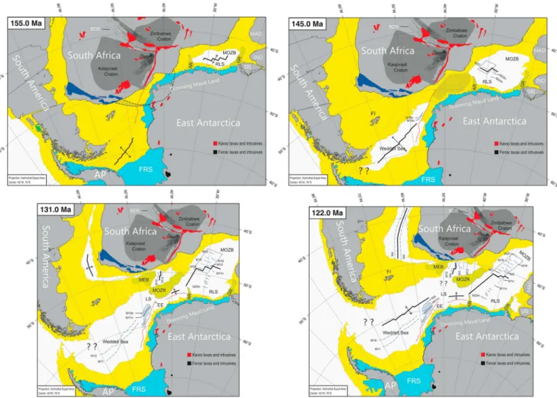
The Weddell Sea has undergone substantial changes through geologic time. The current picture of a sea‐ice infested ocean basin, where only a few times in the recent history ships (USCGCGlacier, R.V.Polarstern, and H.M.S.Endurance) were able to enter its southwesternmost rim, that is, the waters offshore from the wes- ternmost Ronne Ice Shelf, is just a snapshot in its geological evolution. During the Early Jurassic, some 180 million years ago, the Weddell Sea did not exist. Instead, the area was located within Gondwana and occupied by landmasses that today form Patagonia and the Falkland Islands (Figure 5). In contrast to the present‐day cold climate, a temperate climate with landscapes that we know from present Europe prevailed in the Weddell Sea region during that time. However, during the Jurassic, the Gondwanan supercontinent
Figure 5.The four panels show the evolution of the Weddell Sea since Jurassic times (modified after Jokat et al., 2003). Dotted white areas: oceanic basins; bold black lines in oceanic basins: mid‐ocean ridges; black arrows: spreading directions; dark blue solid and dash‐dotted lines: magnetic chrons symmetric to the mid‐ocean ridges, which formed by subsequent seafloor spreading; dark blue area: Cape Fold Belt; black dashed lines: magnetic anomalies; thin red lines: outlines of escarpments; yellow areas: extended continental crust; blue areas: present‐day ice shelves around Antarctica, dark gray areas: outlines of South African cratons, which form the oldest crust in the region; red and black areas: locations of remnants of volcanic and intrusive rocks formed during the Gondwana breakup. In Antarctica, most of these magmatic rocks are covered by a thick ice sheet.
Abbreviations for all panels: AR = Astrid Ridge; AP: Antarctic Peninsula; BDS = Botswana Dyke Swarm; EE = Explora Escarpment; FI = Falkland Islands; FRS = Filchner‐Ronne Ice Shelf; GR = Gunnerus Ridge; IND = India; LS = Lazarev Sea; MAD = Madagascar; MEB = Maurice Ewing Bank; MOZB = Mozambique Basin;
MOZR = Mozambique Ridge; RLS = Riiser Larsen Sea; SRI = Sri Lanka.
(top left) Panel 155 Ma: This panel shows the configuration of tectonic plates ca. 10 Ma after breakup had started between Africa and Antarctica around 165 Ma.
While oceanic crust was already forming in the MOZB, the Weddell Sea region was underlain by a largely extended, continental basin. The bold black line in the Weddell Sea (representing a possible spreading center) is hypothetical because little is known about the very early evolution of the Weddell Sea. The hatched area indicates a possible connection between magnetic anomalies in South Africa and Dronning Maud Land.
(top right) Panel 145 Ma: Magnetic spreading anomalies in the eastern part of the Weddell Sea put clear age constraints on the evolution of the entire basin. The Weddell Sea opened stepwise from east to west at a rate of 63 km per Million year (Jokat et al., 2003; König & Jokat, 2006). The South Atlantic was an area of largely extended continental basins at this time. The hatched area indicates the location of a shallow sea or a still subaerial region, highlighting the uncertainties in this reconstruction. The question marks in the northern part of the AP indicate that we have no information about the tectonic evolution of Patagonia relative to the AP. (lower left) Panel 131Ma: While the Weddell Sea, the RLS and its conjugate MOZB are already well‐developed ocean basins, the South Atlantic starts to open from south to north. The spreading history between the MEB and the MOZR is rather complex. Here the panel shows the current state of knowledge.
(lower right) Panel 122 Ma: The configuration of the Southern Ocean is similar to today, with well‐separated continents around it and in its center. Seafloor spreading is now widely active. Again, the kinematic evolution of the northwestern Weddell Sea (“??”) is poorly constrained, since most of the crust was subducted at the present‐day South Sandwich Trench during the Paleocene to Oligocene. All Mesozoic spreading anomalies on the South American side were destroyed by both this subduction and subsequent formation of the Drake Passage. It is highly unlikely that a connection between the Weddell Sea and the Pacific Ocean already existed at this time (as the panel suggests) because numerous microcontinents populated this gateway around 122 Ma (Eagles & Jokat, 2014).
began to rift apart and break up (Jokat et al., 2003). During its latest rift phase, the young Weddell Sea was a region with massive but short‐lived volcanism caused by plate movement (Storey, 1995). During the period from the Cretaceous through the Eocene, while South America and South Africa moved equatorward and Antarctica drifted poleward, the Weddell Sea grew. The oldest sedimentary strata recovered by Ocean Drilling Program (ODP) Leg 113 are of Early Cretaceous age and were drilled in the eastern Weddell Sea (Kennett & Barker, 1990). In this area, rock dredging along the scarps of Wegener Canyon sampled a thick section of Late Jurassic to Early Cretaceous, organic rich sedimentary rocks (Fütterer et al., 1990). In addition, ODP Leg 113 drilled a Miocene‐Pleistocene turbidite sequence in the abyssal plain of the central Weddell Sea and a sequence of Eocene to Pleistocene hemipelagites and contourites on the West Antarctic continental marginflanking the southwestern part of the Weddell Sea (Kennett & Barker, 1990). After the Drake Passage had opened between South America and Antarctica about 35 million years ago (Eagles & Jokat, 2014), the Weddell Sea became tectonically passive, with the bathymetry we know today.
Little is known about the sedimentation and oceanography before the opening of the Drake Passage.
However, there is some evidence from seismic (Lindeque et al., 2013) and geological data (Carter et al., 2017; Mackensen & Ehrmann, 1992) as well as from modeling results (Douglas et al., 2014; Ladant et al., 2014) that a proto‐WG existed already during the Late Eocene‐Early Oligocene and potentially even during Cretaceous times. Due to the absence of a large ice sheet during the Cretaceous, the oceanic circulation within the Weddell Sea was controlled by wind, while the sediments deposited within the WG predomi- nantly originated from the discharge of large river systems, which supplied material eroded from the tempe- rate interior of East Antarctica to the ocean. During that time, the WG might not have had the important role for global thermohaline circulation that it has today because the mechanisms that are responsible for the production of precursor water masses for dense AABW today (i.e., supercooling of ocean water under ice shelves and brine rejection in polynyas) were not active under global atmospheric“greenhouse”conditions and in the absence of large ice sheets.
This situation changed with the stepwise opening of the Drake Passage between Patagonia and the northern tip of the Antarctic Peninsula. While Antarctica slowly drifted southward and the Passage widened (Eagles &
Jokat, 2014; Lawver & Gahagan, 2003; Livermore et al., 2007; Scher & Martin, 2006) and global atmospheric CO2dropped significantly (Beerling & Royer, 2011; Pagani et al., 2011; Y.G. Zhang et al., 2013), the Antarctic continent became oceanographically isolated, and its environment changed to a polar climate (Cristini et al., 2012; DeConto & Pollard, 2003; Escutia et al., 2019; Galeotti et al., 2016; Mackensen & Ehrmann, 1992;
Pollard et al., 2013). Little is known about the exact size and dynamics of the Oligocene Antarctic Ice Sheet. There is ample far‐field (e.g., deep‐sea records of oxygen isotopes in benthic foraminifera shells, global deep‐water temperature records, and global sea‐level records) and proximal evidence (e.g., deposition of sub- glacial tills on the Antarctic shelf, Southern Ocean surface water temperature records, and geochemical and mineralogical evidence for a shift from chemical to physical weathering) that a large ice sheet formed in East Antarctica at the Eocene‐Oligocene boundary (e.g., Basak & Martin, 2013; Coxall et al., 2005; Ehrmann &
Mackensen, 1992; Galeotti et al., 2016; Gulick et al., 2017; Hambrey et al., 1991; Lear et al., 2000; Miller et al., 2005; Zachos et al., 2008). Ephemeral ice sheets had previously existed there during the Late Eocene (Carter et al., 2017; Gulick et al., 2017; Scher et al., 2014, and references therein). Thefirst large, continent‐wide, stable ice sheet developed during the Mid‐Miocene cooling step (e.g., Lear et al., 2000; Miller et al., 2005;
Shevenell et al., 2004). Consequently, the sediments were no longer eroded by rivers but by glaciers, and the oceanography of the entire Weddell Sea changed from that of a temperate to a polar ocean basin since at least the Mid‐Miocene (Anderson et al., 2011). The extent of Antarctica's massive erosion is well documen- ted by the thick sedimentary sequences deposited on the continental margin in the Weddell Sea. For exam- ple, at its southernmost margin, just in front of today's Filchner‐Ronne ice shelf, sediments deposited since the Jurassic are up to 12 km thick (Huang et al., 2014; Jokat & Herter, 2016). Miocene continental shelf pro- gradation, its impact on AABW formation, and the evolution to present sediment transport processes and deposits in the southeastern Weddell Sea were reconstructed by seismic‐stratigraphy and modeling (Huang et al., 2017). These data show that the Antarctic ice sheets were quite dynamic since at least the Mid‐Miocene.
Several advances/retreats of the ice sheets in the southern Weddell Sea throughout the Quaternary are docu- mented in seismic and acoustic data and in marine sediment cores from the continental margin (Anderson et al., 1991; Diekmann et al., 2003; Elverhøi, 1981; Gales et al., 2014; Gilbert et al., 1998; Grobe & Mackensen,
1992; Grobe et al., 1990; Hillenbrand et al., 2014; Kristoffersen et al., 2000; Kuhn & Weber, 1993; Larter et al., 2012; Mackensen et al., 1989; Melles & Kuhn, 1993; Michels et al., 2002; Ó Cofaigh et al., 2001; Pudsey et al., 1988; Shimmield et al., 1994; J.A. Smith et al., 2010; Weber et al., 2014), with sedimentary sequences from the southeastern Weddell Sea providing archives for decadal and perhaps annual resolution of ice dynamics because of the very high sedimentation rates (Sprenk et al., 2014; Weber et al., 2011). Sediment core and geophysical data indicate that the size of the Antarctic ice sheets in the Weddell Sea sector varied significantly during the last 2 million years, possibly in tandem with the global climate cycles of the Quaternary (e.g., EPICA Community Members, 2004; Lisiecki & Raymo, 2005).
For the Last Glacial Maximum (LGM; ca. 19–23 Kyr BP), the extent of grounded ice‐sheet advance across the southern Weddell Sea shelf, and the magnitude of ice‐sheet growth in the Weddell Sea drainage sector is not sufficiently understood (Bentley et al., 2010, 2014; Hillenbrand et al., 2014; Larter et al., 2012; Whitehouse et al., 2017). This has significant implications for (a) the estimate of Antarctica's contribution to the eustatic sea‐level lowstand of ~130 m below present at the LGM and phases of rapid, major global sea‐level rise (“meltwater pulses”) during the last deglaciation (Weber et al., 2014) and (b) the production of precursor water masses (High Salinity Shelf Water and Ice Shelf Water [ISW]) for Weddell Sea Deep Water and Weddell Sea Bottom Water, and thus AABW, during the LGM. Grain size data from deep‐sea cores indicate that outflow of AABW from the WG into the South Atlantic basin was apparently reduced during glacial times (Diekmann et al., 2003; Gilbert et al., 1998). The same may apply to the current vigor of the WG due to the expanded glacial‐time sea‐ice cover that shielded the surface ocean from the westerly winds (McCave et al., 2014). However, high salinities reconstructed for glacial bottom waters from the South Atlantic basin suggest that AABW production persisted through glacial periods (e.g., Adkins, 2013;
Adkins et al., 2002). While most of the deep Weddell Sea may have been covered by perennial sea ice at the LGM (Collins et al., 2013; Gersonde et al., 2005), geochemical and micropaleontological data from sedi- ment cores revealed that even then (seasonal), polynyas must have persisted within the sea ice covering the Antarctic continental margin in the WG (Grobe et al., 1990; Smith et al., 2010; Weber et al., 2011). Thus, pre- cursor water masses for AABW might have formed within these glacial‐time polynyas by brine rejection (Mackensen et al., 1996).
During the present interglacial, deposition in the Weddell Sea is dominated by an interplay between ice raft- ing and current transport (Diekmann & Kuhn, 1999; Howe et al., 2007; Pudsey & King, 1997).
Geographically, the present‐day sedimentation pattern in the WG can be split into three geomorphological regions (Jerosch et al., 2016): (i) a southern and eastern region, influenced by downslope transport of sedi- ments near the glaciated continental margin with channel‐levee deposits and contourites (Michels et al., 2002); (ii) the central and northern WG, dominated by slowly accumulating sediments of mostly terrigenous origin (Geibert et al., 2005; Howe et al., 2007); and (iii) a northwestern part with contourites and hemipela- gites (Gilbert et al., 1998; Pudsey et al., 1988). In addition, Maud Rise in the eastern part of the gyre (Huang &
Jokat, 2016) and the Polarstern Bank in the southern Weddell Sea (Bart et al., 1999) stand out from the surrounding abyssal plain with a cover of biogenic sediments (Abelmann et al., 1990; Figure 2).
From the coast, dense water masses and turbidity currentsflow down the continental slope through chan- nels and feed into large canyon systems extending across the continental rise (e.g., Amblas & Dowdeswell, 2018; Howe et al., 2007; Michels et al., 2002; Pudsey et al., 1988). Thus, these currents deposit sediments on the continental slope and rise but transport detritus even further down to the Weddell abyssal plain.
The downslope transport processes are assumed to be much less active during interglacial times than during glacial periods (e.g., Gales et al., 2014; Lindeque et al., 2013) because of the“bulldozing”effect and subglacial till transport to the shelf break by advancing grounded ice with subsequent downslope redeposition during the latter times (e.g., Grobe & Mackensen, 1992). Sediment distribution is not spatially homogenous, with large fans extending hundreds of kilometers from the shelf break and sediment drifts forming depocenters on the rise (Gilbert et al., 1998; Huang et al., 2014; Kuhn & Weber, 1993; Kuvaas & Kristoffersen, 1991;
Michels et al., 2002). Toward the inner WG, deposition dominated by gravitational downslope transport changes gradually to pelagic sedimentation, with sediments being deposited at rates of only a few milli- meters per 1,000 years (e.g., Pudsey et al., 1988) and consisting predominantly of lithogenic components (e.g., Howe et al., 2007; Schlüter et al., 1998). This contrasts with sediments on the Antarctic continental margin to the south and southwest of the WG and those underlying the ACC to the north, which both con- tain higher amounts of biogenic particles and are deposited at higher rates (e.g., Howe et al., 2007; Pudsey &
King, 1997; Schlüter et al., 1998). The fact that the surface waters overlying the opal‐poor sediments of the Weddell abyssal plain are known to be at least occasionally highly productive, with diatom blooms occurring during spring and summer, implies that biosiliceous particles must be affected by strong dissolution in the water column and at the seafloor (Howe et al., 2007; Pudsey & King, 1997; Schlüter et al., 1998; Usbeck et al., 2002). This is confirmed by both the observation of diatom dissolution in seafloor surface sediments (Zielinski et al., 1998) and detailed geochemical studies on these sediments (Schlüter et al., 1998), and it is also reflected in the spatial grain size distribution (Figure 6) which shows a clear dominance of clay‐sized particles (<2μm) in the sediments underlying the central WG (Diekmann et al., 2003; Petschick et al., 1996). In summary, thefluxes of biogenic opal, that is, mainly the remains of diatoms and radiolaria, are high toward the WG boundaries but very low in the center (Geibert et al., 2005).
Toward the north and east of 20°E, a transition to biogenic sediments is seen, but the band of siliceous sediments surrounding Antarctica is clearly a feature of the ACC, not the WG. The outflow of deep‐water masses from the WG into the South Atlantic basin is restricted by bathymetric highs in the Scotia Sea (Naveira Garabato et al., 2002). In general, surface currents follow the sameflow paths, thereby steering the drift paths of icebergs. Therefore, sedimentary records deposited at locations along these pathways offer unique opportunities for reconstructing past changes in bottom water flow and iceberg discharge (Diekmann et al., 2003; Gilbert et al., 1998; Ó Cofaigh et al., 2001; Weber et al., 2014), hence the International Ocean Discovery Program (IODP) Expedition 382 to “Iceberg Alley” in early 2019 (https://iodp.tamu.edu/scienceops/expeditions/iceberg_alley_paleoceanography.html).
2.2. Research Priorities
1. Despite the progress achieved over the last two decades in reconstructing the timing and processes of gateway opening around Antarctica during the last ca. 45 Ma, questions relating to the development of the WG are still unresolved, because of the lack of scientific drill holes (Escutia et al., 2019). For example, it is unclear (a) how the WG's current system changed in response to the opening of the nearby Drake Passage gateway and thus numerical models simulating these changes (e.g., England et al., 2017; Yang et al., 2014) remain untested, and (b) whether the subsidence of the seafloor in Drake Passage and the neighboring Scotia Sea below a distinct paleo‐bathymetric threshold depth was required for the full development of the ACC and the WG.
2. The role of the growing Antarctic ice sheets since the late Paleogene for steepening the atmospheric mer- idional temperature gradient and thus strengthening the Southern Hemisphere westerlies and initiating the clockwiseflowing ACC and the WG is still unclear. Some model experiments suggest that the exis- tence of a large ice sheet on Antarctica could be essential for driving both the ACC and the WG (e.g., Ladant et al., 2014). Other modeling results imply that alternative mechanisms, such as variations in heat supply to the gyre caused by changes in regional thermohaline circulation, could be one of the main driv- ing forces (e.g., Douglas et al., 2014).
Figure 6.Weight percentage of the clay‐sized fraction (<2μm) in seabed surface sediments (data from Diekmann et al., 2003; Schlitzer, R., Ocean Data View, odv.awi.de, 2018).
3. Other issues that need to be addressed are how thefluctuations in the size and volume of the Antarctic ice sheets during the last 2 million years influenced the WG and how the resulting changes in the WG influ- enced the global oceanic circulation system and thus global climate. Even for the LGM, it is still unclear whether precursor water masses for AABW could have been produced under ice shelves fringing the southern margin of the WG or whether ice grounded on the entire continental shelf prevented the pro- duction of those water masses (Hillenbrand et al., 2014), and precursor‐water masses for AABW formed in polynyas over the continental slope instead (Mackensen et al., 1996).
4. Another important open question addresses our understanding of biogeochemical processes: Why are sediments rich in biogenic opal absent from the seafloor underlying the central WG despite significant diatom productivity taking place in the surface waters?
3. Physical Oceanography
Alongside the atmosphere, the ocean plays a key role in the climate system in redistributing excess heat from the Equator toward the polar regions. The key ways in which this latitudinal transport of heat is achieved are through the system of vertically separated ocean currents known as the global overturning circulation and through a series of wind‐driven, large‐scale horizontal circulations known as ocean gyres. The Southern Ocean is a particularly important region for the transport of ocean heat, nutrients, and carbon as in this region, these climatically important quantities are exchanged between the main Atlantic, Pacific, and Indian Ocean basins within the ACC. The Southern Ocean is also the location where deep ocean waters, which have been isolated from the atmosphere for hundreds to thousands of years, are returned to the surface and can exchange their properties with the atmosphere. Moreover, certain regions around the Antarctic continent itself (the WG being a prime example) are key locations for the formation and modifica- tion of the densest ocean waters. These waters, made dense through rapid surface cooling and rejection of salt as sea ice is formed, subsequentlyfill the deepest parts of the Southern Hemisphere's ocean abyss.
The complexity of the physical processes occurring within the WG region, our lack of knowledge, particu- larly of the wintertime physics, and the subsequent impact of the newly formed waters on the global ocean circulation mean that addressing the gaps in understanding in this region is a global climate priority.
3.1. The State of Knowledge
While the WG might appear externally as a relatively hermetic bowl with few isolated, well‐defined inflows and outflows (e.g., Orsi et al., 1993), it is dynamically complex and highly variable, influenced by physical processes spanning several orders of magnitude in spatial and temporal scales.
At low frequencies, climate modes have been shown to influence both the strength of the gyre and Weddell Sea sea‐ice extent. Martinson and Iannuzzi (2003) observed a spin‐up in WG during El Niño conditions, with a weakening occurring during La Niña events. Furthermore, they found a strong dipole in sea‐ice extent, with positive anomalies in the WG occurring contemporaneously with reduced Amundsen/Bellinghausen sea ice (and vice versa). More recently, Armitage et al. (2018) investigated the seasonal variability in the gyre strength from sea surface height estimates and concluded that the month‐to‐month circulation of the WG is strongly controlled by local wind stress curl (r = −0.67 between gyre strength and wind stress curl). Furthermore, both modeling (Mathiot et al., 2011) and observations (Núñez‐Riboni & Fahrbach, 2009) support the observation that the seasonal mass transport of the Antarctic Slope Front (ASF), which runs along the southern side of the WG, is controlled largely by the strength of the easterly winds. The properties of the AABW, the dense water mass which forms on the continental shelves of the Weddell Sea before being exported to the South Atlantic, are also sensitive to change in wind forcing over the gyre. Jullion et al. (2010), using 15 hydrographic sections, argued that wind stress variability over the WG forced changes in AABW properties in the SR1b hydrographic sec- tion to the east of Drake Passage, with a lag time of around 5 months, which they ascribed to a barocli- nic adjustment of the gyre. This forcing has effects outside the Weddell Sea, with Meijers et al. (2018) arguing that the intermittent presence of a cold, fresh slope current north of Elephant Island is attribu- table to variable export from the Weddell Sea, driven in turn by wind‐driven acceleration of the bound- ary current. Kerr et al. (2018) have also argued for a long‐term decline in the densest constituent of this bottom water, the WSBW, though some recovery in volume has occurred since 2005.
In contrast to these large‐scale controls, there is also clear evidence that highly variable small‐scale turbulent mixing has a key role in setting the thermohaline properties of the AABW that leaves the Weddell Sea through deep outflows to the north. Polzin et al. (2014), for example, have argued that elevated boundary mixing just north of Orkney Passage is key to transforming WSDW on entering the Scotia Sea.
Understanding such small‐scale processes is vital to interpreting long‐term changes in AABW properties that have been observed in the South Atlantic, including the both warming and reduction in volume (Meredith et al., 2008; Purkey & Johnson, 2010). Furthermore, it has been argued that the occasional but per- iodic opening of the Weddell Polynya (Carsey, 1980), an area of open water of up to 3 × 10⁵km2, which appeared in winters of 1974–1976 and again in 2016 and 2017, can short‐circuit the usual deep‐water forma- tion processes by rapid open ocean buoyancy loss and deep convection. However, recent literature (e.g., Dufour et al., 2017) has emphasized the importance both of an interior heat reservoir and of mesoscale eddy activity on triggering polynya development. It has also been suggested that a prolonged negative phase of the Southern Annular Mode (SAM) might be implicated in allowing the polynya to open (Gordon et al., 2007).
Away from the densest waters, mixing processes are much less well understood. Muench et al. (1990) have observed large (up to 100 m) thermohaline staircases in the northwestern Weddell Sea, separating the warm CDWs from the overlying cooler and fresher layers, suggesting that these staircases were a key mechanism for vertical heat transport within the thermocline. While it appears that overall mixing rates in the interior waters are likely to be weak, the lack of observations of turbulent mixing processes in the Weddell Sea remains a key limitation on our knowledge of the gyre interior.
In general terms, the Weddell Sea is characterized by a strong coupling between the WG (transporting about 50 Sv [1 Sv = 1 × 10⁶m3/s] cyclonically; Klatt et al., 2005; Q. Wang et al., 2012) and an intense overturning circulation, both forced by westerly and easterly winds over its northern and southern edges, respectively, as well as by buoyancyfluxes. Relatively warm and salty CDW (the voluminous midlayer water of the ACC, with its origins in the North Atlantic; Callahan, 1972) enters the gyre at its eastern edge and while concurrently rising (Donnelly et al., 2017)flows toward the southwestern Weddell Sea. This is illustrated in Figure 7, which shows the temperature of the subsurface temperature maximum from objectively mapped Argofloat data (modified from Reeve et al., 2016). Here it intrudes onto the continental shelves as modified WDW and mixes with cold shelf waters that are made more saline by brine rejection during sea‐ice forma- tion. The intense air‐sea‐ice interaction that precedes brine rejection occurs on the shelf in front of the exten- sive ice shelves—the Filchner‐Ronne (Nicholls et al., 2009) and Larsen (van Caspel, Absy, et al., 2015; van Caspel, Schröder, et al., 2015; Huhn et al., 2008)—and the resultant mixture of WDW and dense shelf waters leads to dense water formation. As this water mass descends, it entrains midlayer waters, before being exported northward and westward (Kilworth, 1974; Wilchinsky & Feltham, 2009). Ultimately, only the shal- lower portion of this water—the WSDW—is sufficiently light to overflow into the Scotia Sea. The WG has traditionally been considered as the main source of AABW production (Orsi et al., 1999). However, recent work has challenged this view, arguing that up to 50% of the AABW exported across the northern rim of the gyre is imported into the gyre from the Indian sector of the Southern Ocean (Jullion et al., 2014;
Naveira Garabato et al., 2014). It has been proposed that one of these pathways is dominantly advective, while the other is dominantly eddy driven (Ryan et al., 2016).
3.2. Research Priorities
Despite recent oceanographic advances in our understanding of the WG, several pressing issues remain unresolved. These are discussed in the following subsections.
3.2.1. Connection With the Rest of the Southern Ocean
As stated previously, the eastern boundary of the WG remains poorly resolved with no well‐defined bound- ary current marking its eastern periphery. The traditional defined limit of the WG is located around 30°E but can extend as far as the Kerguelen Plateau at ~70°E (Y.H. Park et al., 2001). Two main routes for CDW into the WG have been identified (Cisewski et al., 2011; Fahrbach et al., 2011; Núñez‐Riboni & Fahrbach, 2009;
Ryan et al., 2016).
First, there is a direct, eddy‐driven route in the northeastern corner of the WG carrying warm and salty CDW into the gyre (Jullion et al., 2014; Leach et al., 2011; Ryan et al., 2016; Schröder & Fahrbach, 1999). This is thought to be generated by a topographic discontinuity in the southwest Indian Ridge (55°S, 25°E) as
suggested by elevated levels of mesoscale eddy kinetic energy just downstream of this trough and by idealized numerical simulations (Witter & Chelton, 1998).
A second advective pathway into the WG is via the ASF, which carries CDW (Cisewski et al., 2011) from the far east but also, more surprisingly, appreciable quantities of recently formed AABW (Archambeau et al., 1998; Hoppema et al., 2001; Meredith et al., 2000). This AABW, most likely originating from intense sea‐ice formation within the Cape Darnley Polynya near 70°E (Ohshima et al., 2013), contributes significantly to the gyre's overall AABW inventory (Jullion et al., 2014; Naveira Garabato et al., 2014) and exhibits thermohaline variability that is not yet fully understood (Couldrey et al., 2013). While we now have some knowledge of the climatology of the eastern WG, there remain great uncertainties concerning its variability (both in terms of transport as well as water mass properties) and the relative contribution from eddies.
3.2.2. Changes in Air‐Sea‐Ice Interactions
The WG is subject to strong and complex thermodynamical forcing, including interactions with ice shelves (Nicholls et al., 2009) and a strong seasonal cycle of sea‐ice extent (Zwally et al., 2002), as well as precipitation (Bromwich et al., 2011) and intense transfers of heat across the sea surface. Together, these lead to significant cooling and freshening of the inflowing CDW during the formation of new water masses (Jullion et al., 2014). The changes in buoyancy driving these water mass transformations are set by a delicate interplay between the different sources and sinks. In the center of the gyre, buoyancy gain occurs via sea‐ice melt and the addition of meteoric water; these processes have a key role in driving the upper overturning cell. In addition, buoyancy loss also occurs, through sea‐ice formation and large ocean‐to‐atmosphere heat fluxes near the southern and western margins of the gyre. The cancellation of these two terms leads to a small residual buoyancy gain in the gyre, but both contributions significantly contribute to both limbs of the overturning circulation of the Southern Ocean (Naveira Garabato et al., 2016). However, strong seasonality in both the gyre and the buoyancy forcing and the scarcity of wintertime observations greatly limit our ability to describe processes at play in detail and thus to predict future responses under climate change scenarios. The observed changes in sea‐ice extent (Hobbs et al., 2016;
P. R. Holland & Kwok, 2012) and glacial runoff (P. R. Holland et al., 2015) as well as the potential sensitivity to changes in the buoyancy forcing of both overturning cells highlight the urgent need to better understand the physical processes underpinning the buoyancy budget and their variability on monthly to decadal time scales.
Figure 7.The Weddell Gyre: temperature (°C) at the subsurface temperature maximum, derived from optimally interpolated Argofloat data (from Reeve et al., 2016; http://doi.org/10.17882/42182). Thefigure shows clearly the pene- tration of Circumpolar Deep Water (CDW) from the east on the southern side of the gyre, and the rapid cooling of the middepth waters on the western side of the Weddell Sea as Antarctic Bottom Waters are formed. The arrows show the dominant middepthflow direction of the gyre, and WDW is Warm Deep Water. The penetration of CDW from the east can clearly be seen, along with its cooling as it advects eastward along the southern edge of the Weddell Gyre.
3.2.3. Cross‐Shelf Processes
In the WG, the ASF plays a central role in mediating cross‐shelf exchanges of mass and heat and therefore directly influences processes such as ice‐shelf stability, sea‐ice production, and dense water formation.
Despite its importance, little is known about the slope front variability and its dynamical drivers.
Idealized numerical simulations show that export of bottom water from the shelf toward the deep ocean is sensitive to changes in easterly wind stress near the Antarctic coast (Stewart & Thompson, 2012). Novel glider observations (Azaneu et al., 2017) have also suggested that the passage of eddies and changes in bottom slope may also be responsible for high‐frequencyfluctuations in current strength. Hellmer et al.
(2012) suggested that global‐warming‐related reduction of sea‐ice cover in the southeastern Weddell Sea changes the oceanic surface stress, which may lead to an advection of warm water from the open ocean toward the Filchner‐Ronne ice shelves causing a dramatic increase in basal melting by 2100.
Scarce observations in the Weddell Sea as well as idealized numerical modeling hint that mesoscale eddies contribute significantly to the cross‐shelf transport of warm water onto the shelf. The current state of under- standing is that both tides and eddies are significant in effecting cross‐shelf exchange (Nøst et al., 2011; A.F.
Thompson et al., 2014; Stewart et al., 2018; see also section 3.1), with onshore eddy and Ekman‐driven trans- ports being balanced by offshore near‐bottomflows. However, most of this understanding comes from numerical simulations (both realistic and idealized). Further targeted process studies including high‐
resolution hydrography, velocity, and mixing measurements will be required to provide fundamentally improved understanding of the physical drivers underpinning the ASF dynamics and associated cross‐ shelf exchanges.
3.2.4. Water Mass Variability and Export
Hydrographic data reveal that the water mass properties associated with the WG overturning display inter- annual to decadal variability. Winter Water and WDW (the Weddell Sea variant of CDW) are subject to significant multiannual variability (Behrendt et al., 2011; Fahrbach et al., 2011), possibly forced by changes in the inflowing CDW (Cisewski et al., 2011). Moreover, the export of Central Intermediate Water (CIW) is thought to be strongly modulated by wind‐driven acceleration of the boundary current of the gyre (Meijers et al., 2017). The observed variability of AABW is spatially strongly structured. Within the inner WG, AABW is dominated by multiannual variability in thermohaline properties (Fahrbach et al., 2011), though chloro- fluorocarbon and sulfur hexafluoride (SF6) data suggest a decrease of the AABW ventilation and related reduction of anthropogenic CO2uptake (Huhn et al., 2013). The cause (internal variability or an externally forced trend) and origin of this process (local or remote) remain elusive. In the eastern WG, AABW originat- ing from Cape Darnley appears to have warmed during the 1990s and 2000s (Couldrey et al., 2013), and the AABW leaving the Weddell Sea has been consistently freshening since the 1990s (Hellmer et al., 2011;
Jullion et al., 2013), but there also appears to be significant interannual variability forced by local adjust- ments in the circulation (Jullion et al., 2010; Meredith et al., 2008, 2011). The narrow gaps that dissect the South Scotia Ridge (the Orkney Passage in particular) through which bottom water is exported (Franco et al., 2007; Jullion et al., 2014; Naveira Garabato et al., 2002) actively contribute to the water mass modifica- tion via complex dynamical processes in bottom‐intensified jets (Polzin et al., 2014). Over longer time scales, coupled general circulation models predict a rapid reduction in open‐ocean convection in the WG over the coming century in response to greenhouse gas forcing (de Lavergne et al., 2014), though most coupled cli- mate models do not accurately represent the scale and rate of convective processes occurring in the Weddell Sea (Heuzé et al., 2013).
Overall, our picture of the physical variability and time‐varyingflows in the WG has evolved greatly in recent years, and its role in large‐scale circulation and climate has become much clearer. However, the gyre is a highly dynamic regime where small‐scale processes play a significant role in the modification of exported water masses and where extant data sets are insufficient to generate the understanding required for accurate reanalysis, simulations, and predictions. Further targetedfield campaigns, building on modern technology such as autonomous vehicles with ice capabilities, are needed to address each of the issues identified above.
Following this, these new insights can be used to improve representations of key processes in numerical models. The recent application of radar altimetry from leads within the ice‐covered ocean (Armitage et al., 2018; Bulczak et al., 2015; Peacock & Laxon, 2004) has, for thefirst time, allowed the circulation of the WG to be measured year‐round, though the processes controlling, for example, the strong seasonal varia- bility in the Slope Current in the WG sector, remain to be fully understood.
4. Cryosphere I: Interactions Between the Ocean and the Ice Shelves
The WG interacts with all components of the cryosphere, that is, sea ice, icebergs, and ice shelves. Sea‐ice formation extracts freshwater from oceanic surface water causing the latter's densification due to brine release. On the broad southern continental shelf, dense water accumulates and fuels basal melting of the ice shelves, also contributing to the formation of deep and bottom waters. Wind and ocean currents in the southern Weddell Sea transport sea ice northward to melt and return freshwater to the central gyre during summer. A large hole—the Weddell Polynya—can sometimes appear near the seamount Maud Rise, where ocean heat melts sea ice also during winter.
Icebergs are driven by winds, ocean currents, and sea‐ice drift in dense pack ice, following the general course of the WG until leaving to melt in warmer waters to the north. They provide freshwater to the ocean and carry iron‐rich continental dust and debris, which might initiate phytoplankton blooms.
Melting of thick ice shelves is cooling and freshening the ocean along the coast. Even cold shelf water is effi- ciently melting the colder deep ice shelf bases. Fresher and hence more buoyant meltwater ascends along the ice base until the pressure release initiates the formation of ice crystals (combined with brine rejection), which attach to the ice base forming a body of marine ice. The water mass with temperatures below the surface freezing point produced in this way is called ISW and contributes to the formation of very dense Weddell Sea Bottom Water.
4.1. The State of Knowledge
Snow accumulation on the Antarctic ice sheet (up to 4,000 m thick) is balanced by the transfer of ice to the ocean, either by iceberg calving at ice shelf fronts or by melting of ice shelf bases (Jacobs et al., 1992). Recent studies, based on remote sensing, have revealed that both transfer mechanisms are of equal importance, and the ice shelf basal mass loss in the Weddell Sea was determined to be 118 ± 52 Gt/year (Depoorter et al., 2013), afigure that is largely controlled by the amount of oceanic heat available for melting. The decrease of the temperature maximum of the WDW from 1.2 °C at the Prime Meridian (Klatt et al., 2005) to 0.6 °C at the tip of the Antarctic Peninsula (Schröder et al., 2002) indicates significant exchange with the cold shelf waters. However, a well‐defined ASF separates the warm waters from the coast.
Ocean‐ice shelf interaction in the Weddell Sea can be separated into three characteristic regional regimes that are dominated by two different principal circulation modes on the continental shelf (Figure 8). In the east (regime I, approximately from 30° E to 30° W, Figure 2), a band of smaller ice shelves fringes the narrow continental shelf (Nicholls et al., 2009) and is in close proximity to the ASF, which is manifested by a strong halocline, deepening toward the shelf break (Figure 8a). Strong ocean currents increase basal melting where the ice overhangs the continental slope (Langley et al., 2014; Price et al., 2008), and basal melting driven by onshore transport of open ocean heat is directly linked to the frontal dynamics (Heywood et al., 1998).
Recent observations and high‐resolution modeling indicate the role of mesoscale eddies formed by ASF instabilities in transporting warm water onto the continental shelf and into the ice shelf cavities (Nøst et al., 2011; Stewart & Thompson, 2015). These eddies are also important in regulating the thermocline depth by balancing the wind‐driven coastal downwelling (Sverdrup, 1954). The latter responds to surface wind stress and near‐surface hydrographic conditions (Hattermann, 2018; Hattermann et al., 2014; Smedsrud et al., 2006) and interacts with bottom corrugations and troughs crosscutting the shelf break, to determine the inflow of warm water toward the ice shelf grounding lines (Hattermann et al., 2012; Nicholls et al., 2006). During summer, the prevailing easterly winds accumulate fresh surface water from sea‐ice melt along the coast, where its admixture to the coastal Winter Water produces Low Salinity Shelf Water (Zhou et al., 2014), while downwelling of this solar‐heated surface water seasonally increases melting beneath the ice shelves (Hattermann et al., 2012).
The Filchner‐Ronne Ice Shelf, the largestfloating volume of ice on the planet at 3·105km3, located in the southern embayment of the Weddell Sea (regime II, 30° W to 60° W, south of 70° S; Figure 2), is separated from WDW by a wide continental shelf. The circulation in the ice shelf cavity is driven by tides and density currents associated with High Salinity Shelf Water (Figure 7b) formed by intense sea‐ice production in poly- nyas and leads near the ice shelf front (Haid et al., 2015; Tamura et al., 2008). The freshwater extraction due to sea‐ice formation causes salinification, and thereby densification of the shelf water masses, ultimately contributing to the formation of deep and bottom waters at the continental slope and giving rise to a
V‐shaped halocline that guides Low Salinity Shelf Water along the shelf break (Gill, 1973). High Salinity Shelf Water at the surface freezing point provides the oceanic heat for area‐mean basal melt rates of a few decimeters per year (several meters per year locally along the deep grounding line), because the freezing point is reduced at higher pressure (Jacobs et al., 1992). The resulting water mass, ISW, partially refreezes at intermediate depths beneath the ice shelf as part of the“ice‐pump”mechanism (Lewis & Perkin, 1986) and contributes to the formation of Weddell Sea Deep and Bottom Water (Nicholls et al., 2009). Traces of modified WDW have been observed to enter the continental shelf (Nicholls et al., 2008), mainly through topographic depressions such as the Filchner Trough, which connects the Filchner‐Ronne Ice Shelf cavity with the open ocean (Darelius et al., 2016). The dynamics at the Filchner sill, which determine the inflow of WDW into the trough, involve a complex interplay between the topographically steered current and eddy‐shedding of topographic shelf waves at the mouth of the trough (Daae et al., 2017). The topographically steered current cannot directly cross the sill: vortex stretching of an inflowing current due to the southward deepening of the trough imposes cyclonic relative vorticity, hence, deflecting the current out of the trough. However, model projections indicate that an irreversible regime shift might occur at the sill of the Filchner Trough as a consequence of a warmer climate during the 21st century. Warm waters, transported with the slope current, will reach the deep grounding line of the Filchner‐Ronne Ice Shelf (Hellmer et al., 2012). In the model, the increased inflow of warm water was triggered by shoaling of the Slope Front thermocline at the shelf break (Figure 7a) and freshening of shelf waters due to reduced sea‐ ice formation. Increased basal melting in this warm state drives further shelf freshening, a positive feedback leading to irreversible WDW inflow independent of the applied climate forcing (Hellmer et al., 2017). The additional heat supply used for basal melting has an impact on the ice‐shelf thickness distribution and, thus, iceflow velocities of the ice streams draining the Antarctic ice sheet (Timmermann
& Goeller, 2017). The changing cavity geometry might also significantly influence the tidally induced sub‐ ice shelf heat transport (Mueller et al., 2018). However, large uncertainties remain around these simulations as the occurrence of such a regime shift in the southern Weddell Sea depends on the choice of the atmospheric scenario input (Timmermann & Hellmer, 2013). Other ice shelf‐ocean model projections suggest that melt rates are likely to increase more in the eastern Weddell Sea (Kusahara &
Hasumi, 2013).
At the Filchner sill, a well‐documented overflow of ISW (Daae et al., 2019; Foldvik et al., 2004) exists. This flow, controlled by gravity and bottom topography, underrides the ASF and is a well‐known source for Weddell Sea Bottom Water. Alternatively, the ISW may follow the continental slope toward the west, con- tributing to the formation of Weddell Sea Deep Water (Figure 3).
Along the western perimeter (regime III, west of 50° W, north of 70° S), the WG passes the ice shelves of the Antarctic Peninsula, where observed changes are mostly found to be associated with atmospheric processes (e.g., Scambos et al., 2000). Here the continental shelf circulation combines elements of both principal Figure 8.Schematic of the hydrographic conditions (a) along the continental slope of the eastern Weddell Sea (Hattermann et al., 2014, Open Access) and (b) on the wide continental shelf in the southern Weddell Sea (adapted from Nicholls et al., 2009).