Elaia, the maritime harbour city of ancient Pergamon (Turkey) – Coastal evolution and human impact
over the past eight millennia
Inaugural-Dissertation zur
Erlangung des Doktorgrades
der Mathematisch-Naturwissenschaftlichen Fakultät der Universität zu Köln
Vorgelegt von Martin Seeliger aus Heide in Holstein
Köln 2016
Berichterstatter/Gutachter: Prof. Dr. Helmut Brückner Prof. Dr. Olaf Bubenzer
Tag der mündlichen Prüfung: 29. Juni 2016
Abstract
Abstract
During Hellenistic and Roman times, Elaia, the harbour city of ancient Pergamon, was an im- portant place of trade and traffic at the western coast of Asia Minor. Intense military and mercantile activities are documented by literary sources and archaeological evidences.
This dissertation focuses on (I) the reconstruction of shoreline displacements; (II) the detection of sea-level fluctuations; (III) the usability and history of the three harbour sites; and (IV) the in- vestigation of human impact on the environment since mid-Holocene times in the environs of Pergamon’s so-called “maritime satellite” Elaia. The geo-bio-archives of the area were studied using terrestrial and semi-aquatic vibracorings and geophysical exploration. Investigated sites were measured by Differential GPS. The sediments were examined using sedimentological, mi- cropalaeontological and geochemical methods. Palynological and archaeobotanical analyses provided evidence for the former vegetation. Robust chronostratigraphies were established using radiocarbon (14C) and optically stimulated luminescence (OSL) dating as well as archaeological dating of artefacts.
The postglacial marine transgression drowned the later settled shores of the Bay of Elaia 5500 BC, reaching its maximum ca. 1 km inland around 1500 BC. Since 850 BC, increasing settlement activ- ities in the area led to accelerated hinterland erosion, sedimentation and a seaward shift in the shoreline. The time of the Pergamenian occupation (250 BC–AD 180) is documented by intense building activities and an increased population, which is also visible in the palynolgical record.
During its prime, Elaia operated three harbours: the closed harbour, the open harbour and a beach harbour. The construction of the closed harbour basin was determined by a series of inter- disciplinary methods to 246–215 BC. Estimations of the water depths in the closed harbour basin (~2.5 m in Hellenistic times) and the open harbour area (~1 m in Hellenistic times) led to the conclusion that the closed harbour basin could be exploited by common ship classes until AD 150.
Shortly afterwards, increased siltation led to its abandonment. The closed harbour basin, which shows no signs of dredging activities, acted as a favourable sink for human waste, as evidenced by eggs of parasites, enhanced heavy-metal concentration and debris of craftsmanship. The first detection of the Black Sea dinocyst species Peridinium ponticum in the Mediterranean Sea docu- ments traffic relations with the Black-Sea region. This is supported by archaeological finds of coins, seals and ceramics originating from abroad. Water depth in the open harbour area in front of the ship sheds was insufficient to anchor larger vessels. Thus, the ships were slipped to the ship sheds. The beach harbour in the eastern district of the city of Elaia acted as an area where foreign soldiers and merchants beached their ships and put up their camps.
Abstract
For the first time, a reliable regional sea-level (RSL) curve for a continental site on the Turkish Aegean coast was established using a new type of reliable sea-level index point. The curve corre- lates well with actual RSL curves of the nearby Aegean region; it is also in good agreement with sea-level curves derived from glacio-hydro-isostatic models.
Five stages of human impact are evident over the past eight millennia. The natural vegetation (deciduous oak forests) existed before ca. 850 BC. It is followed by a degradation period caused by increased settlement activities and lumbering until around 250 BC. During Elaia’s most flour- ishing time, ca. 250 BC–AD 180, the human impact is on its maximum, documented by a significant vegetation change, the occurrence of human parasites, debris of craftsmanship, higher heavy- metal concentrations, economic relations and intense construction activity.
The siltation of the harbours in addition to the declining political importance of the city from late Roman times onwards led to its abandonment. Thus, the human impact on the environment de- creased up to around AD 800. Since those days, the absence of human impact led to a new natural vegetation: pines. The climax vegetation of the period before 850 BC never re-established.
To sum up, this PhD thesis is a valuable example of an interdisciplinary cooperation, focused on solving the questions dealing with shoreline displacements, sea-level studies, coastal evolution, hazards and ancient harbour research in an archaeological context.
Kurzzusammenfassung
Kurzzusammenfassung
In hellenistischer und römischer Zeit war Elaia, die Hafenstadt des antiken Pergamon, ein wichti- ger Handelsknotenpunkt an der Westküste Kleinasiens. Die umfangreichen Handels- und Militärfunktionen der Stadt werden durch historische Überlieferungen und archäologische Befun- den belegt.
Diese Dissertation behandelt schwerpunktmäßig vier Themenfelder im Umfeld der antiken Ha- fenstadt Elaia, dem „maritimen Satelliten“ Pergamons: (I) die raumzeitlichen Küstenverlagerungen, (II) die Beschreibung der holozänen Meeresspiegelschwankungen, (II) die Entwicklungsgeschichte und Nutzungsmöglichkeiten der drei Häfen der Stadt und (IV) die Mensch-Umwelt-Beziehungen seit dem Mittelholozän. Hierfür wurden die Geo-Bio-Archive des Untersuchungsgebietes mittels Rammkernsondierung und geophysikalischer Prospektionsme- thoden erschlossen und durch DGPS verortet. Die Sedimente wurden geochemisch, sedimentologisch und mikrofaunistisch untersucht. Des Weiteren lassen palynologische und ar- chäobotanische Studien Rückschlüsse auf die frühere Vegetation zu. Robuste Altersmodelle basieren auf 14C- und OSL-Datierung, ergänzt durch diagnostische archäologischer Funde.
Der postglaziale Meeresspiegelanstieg erreicht die Bucht von Elaia ca. 5500 v. Chr.; sein Maximal- stand um 1500 v. Chr. lag etwa 1 km landeinwärts. Ab ca. 850 v. Chr. führt ein erhöhter Siedlungsdruck und dadurch bedingte erhöhte Erosion zu einer seewärtigen Verschiebung der Küstenlinie.
Der Machtübernahme durch Pergamon um 250 v. Chr. folgt ein deutlicher Bevölkerungszuwachs und ein Höchstmaß an Bautätigkeit. Während seiner Blüte (ca. 250 v. Chr.–180 n. Chr.) verfügt Elaia über drei Häfen: den Geschlossenen Hafen, den Offenen Hafen und einen Strandhafen. Mit Hilfe interdisziplinärer Methoden konnte der Bau des Geschlossenen Hafens auf 246–241 v. Chr.
datiert werden. Die Bestimmung der Wassertiefen im geschlossenen Hafenbecken (ca. 2.5 m in hellenistischer Zeit) zeigten, dass es bis etwa 150 n. Chr. von den gängigen Schiffstypen jener Zeit nutzbar war. Kurze Zeit später zwang zunehmende Verlandung zur Aufgabe des Hafens. Da im geschlossenen Hafenbecken keine Anzeichen für Dredschen vorliegen, eignet es sich als hervor- ragendes Archiv, das anthropogene Einflüsse klar erkennen lässt (Konservierung von menschlichen Parasiten und Abfall aus der Kunsthandwerksproduktion, Anreicherung von Schwermetallen, gute Pollenerhaltung). Darüber hinaus belegt das erstmalige Auffinden der im Schwarzen Meer und im Marmarameer endemischen Dinozyste Peridinium ponticum im Mittel- meer die Handelsbeziehungen zwischen Elaia und dem Schwarzmeerraum. Dies ergänzt den Nachweis durch Münz-, Siegel- und Keramikfunde. Die Wassertiefe im Offenen Hafen (ca. 1 m in
Kurzzusammenfassung
hellenistischer Zeit) war zum Ankern größerer Schiffe nicht geeignet. Statt dessen wurden die Schiffe hier über Rampen in die unmittelbar an Land liegenden Schiffshäuser gezogen. Der Strand- hafen im Osten des Stadtgebietes zeigt keinerlei Hafeninfrastrukturen; seine Wassertiefe unterschied sich kaum vom Offenen Hafen. Die Schiffe wurden dort an Land gezogen und das Gebiet diente fremden Händlern und Soldaten als Lager- und Handelsplatz.
Durch die Entwicklung eines neuen Meeresspiegelindikators konnte erstmals eine belastbare Meeresspiegelkurve für eine Lokalität an der türkischen Ägäisküste erstellt werden. Sie korreliert gut mit Kurven aus dem angrenzenden Ägäisraum und mit den aus glazio-hydro-isostatischen Modellen abgeleiteten Kurven.
Als Ergebnis der Studien zur Mensch-Umweltbeziehung lassen sich fünf Phasen anthropogener Einflussnahme auf die Umgebung von Elaia in den vergangenen rund 8000 Jahren rekonstruieren.
Bis etwa 850 v. Chr. ist die Region aufgrund der weitgehenden Abwesenheit des Menschen von der Klimaxvegetation aus sommergrünen Eichenwäldern geprägt. Bis etwa 250 v. Chr. kommt es durch erhöhten Siedlungsdruck und Rodung zu einer Degradation der Vegetation hin zur Macchie.
Während der Blütezeit Elaias (ca. 250 v. Chr.–180 n. Chr.) erreicht der anthropogene Einfluss sein Maximum, veranschaulicht durch einen signifikanten Vegetationswandel, das verstärkte Aufkom- men von menschlichen Parasiten, Abfallprodukten des Kunsthandwerks, Bautätigkeit und vermehrten Handelsbeziehungen. Die Verlandung des Hafens und der abnehmende politische Einfluss der Stadt ab der späten Römerzeit führen zur Aufgabe der Stadt und einem Verschwinden des menschlichen Einflusses bis 800 n. Chr. Seit jener Zeit führt die Abwesenheit des Menschen zu einer Erholung der Vegetation mit der Etablierung von Kiefernwäldern. Die seinerzeitige Kli- maxvegetation von vor 850 v. Chr. stellt sich allerdings nicht wieder ein.
Zusammenfassend sind die in dieser Doktorarbeit vorgestellten Ergebnisse aus Elaia ein anschau- liches Beispiel für den Mehrwert einer interdisziplinär angelegten Forschung zur Beantwortung von Fragen bezüglich Meeresspiegelschwankungen, Küstenentwicklung, Naturgefahren und anti- ker Hafenentwicklung in einem archäologischen Kontext.
Acknowledgements
Acknowledgements
This dissertation presents the results of my scientific research on Elaia, the harbour city of ancient Pergamon. I am grateful for the opportunity to undertake my studies in the group of Prof. Dr.
Helmut Brückner at the Universities of Marburg and Cologne. With his support, I undertook field- work in the region of Elaia and hold the expertise gained during those journeys to Turkey in high regard. Not only did he facilitate the project in Elaia and helped to carry out fieldwork several times, he also continuously supported my work, encouraged me in many ways, and left space for me to develop my own ideas. Furthermore, he gave me the opportunity to work on the Kane- and Ainos projects.
I will always look back fondly on my time as a PhD student and extend my thanks to all those people who accompanied me during my years in Marburg and Cologne, and who contributed on a professional or personal level to the success of my work.
Prof. Dr. Olaf Bubenzer is thanked for his willingness to co-supervise this thesis. The commission for the defence of this dissertation was completed by Prof. Dr. Frank Schäbitz and Dr. Andreas Bolten, and I would like to thank them for their time and expertise.
All of this would have not been possible without the permanent and generous support of the excavation director in Pergamon, Prof. Dr. Felix Pirson (German Archaeological Institute, Istanbul, Turkey). Yrd. Doç. Dr. Güler Ateş (Celal Bayar Üniversitesi, Manisa, Turkey), Dr. Stefan Feuser (Heinrich Schliemann-Institute of Ancient Studies, Rostock, Germany) and Prof. Dr. Wolf-Rüdiger Teegen (Ludwig Maximilian University, Munich, Germany) are thanked for their assistance with fieldwork in Elaia, and with interpreting and discussing the archaeological and historical contexts of this work. I wish to thank Bernhard Ludwig (M.Sc.), Alexandra Wirsching (M.A.), and the long- standing caretaker of the excavation house in Pergamon Idris Uysal for providing a cosy place to stay during those months in Turkey. The Ministry of Culture and Tourism of the Republic of Turkey kindly granted the research permits.
I thank Prof. Dr. Saït Başaran (excavation director of Ainos; İstanbul Üniversitesi, Turkey) for his generous support during our fieldwork in Ainos (modern: Enez) and the inspirational discussions on the history and archaeology of the Aegean region. His open and sincere nature whilst leading the excavation in Ainos provided valuable insights into the Turkish way of life.
Special thanks are dedicated to the entire working group of Prof. Dr. Wolfgang Rabbel (Applied Geophysics; University of Kiel, Germany) for their cooperation not only in Elaia but also in Ainos and Kane. A very special thanks is due to Dr. Dennis Wilken and Dipl. Geophys. Ercan Erkul for their assistance in interpreting geophysical images of Elaia.
Acknowledgements
PD. Dr. Peter Frenzel (University of Jena, Germany) and Dr. Anna Pint (University of Cologne, Ger- many) are thanked for the identification and interpretation of foraminifera and ostracoda in the sediment samples, and Dr. Lyudmila Shumilovskikh (University of Göttingen, Germany) for her expertise in investigating the pollen of core Ela 70.
Prof. Dr. Christophe Morhange (Aix-Marseille Université, Marseille, France) was an inspiring dis- cussion partner during his stay in Pergamon/Elaia in summer 2014; his interest in my research was very motivating.
Dr. Steffen Schneider (Lower Saxony Institute for Historical Coastal Research, Wilhelmshaven, Germany) offered valuable insights related to fieldwork and discussion of topics relating to the region of Elaia, following his own doctoral research in the nearby Bergama Graben.
To Marita Budde, Christine Günther, Dr. Walter-Wilhelm Jungmann, Dr. Kristof Dorau, Dr. Corinna Földi, Dipl. Geogr. Karin Greef and Dr. Stefan Opitz my dearest thanks are given for their contin- uous and patient guidance during sediment analyses in the laboratories of Marburg and Cologne.
Franz-Rudolf Kniel (car-fleet manager of the German Research Foundation) is thanked for provid- ing us with well-maintained vehicles for our trips to Turkey.
On a personal level, I would like to take this opportunity to express my endless gratitude to Dr.
Dominik Brill and Dr. Max Engel, my office colleagues during my time in Cologne. They created a friendly office atmosphere which I thoroughly enjoyed – not to forget Dr. Daniel Kelterbaum for being my closest companion and friend at work. Special thanks are also dedicated to Marina Her- brecht for her help during fieldwork and in the laboratory.
Further supporting the fieldwork I would like to thank: Anja Anklamm (M.Sc.), Angela Balk (M.Sc.), Melanie Bartz (M.Sc.), Dr. Nicole Klasen, Laura Linck (B.Sc.), PD Dr. Nick Marriner, Verena Medinger (M.Sc.), Dipl. Geogr. Florian Steininger, Dr. Levent Uncu and Karl Wutzer (B.Sc.). Dipl.
Geogr. Florian Steininger maintained the coring and fieldwork equipment and gave helpful hints for its proper use.
PD Dr. Nick Marriner (Université de Franche-Comté, Besançon, France), Dr. Christine Seeliger (Garvan Institute of Medical Research, Sydney, Australia), Dr. Georgina King (University of Co- logne), and Svenja Riedesel (B.A.; University of Cologne, Germany) spent time reading this manuscript and provided valuable feedback on structure, figures, and last but not least language editing.
The studies in Elaia were funded by the German Research Foundation (DFG; ref. nos. PI 740/1-3 and BR 877/32-1). The “Graduate School of Geosciences (GSGS)” of the University of Cologne, the
Acknowledgements
“German Work Group on Geomorphology (AK Geomorphologie)” and the “Charles McBurney La- boratory for Geoarchaeology” of the University of Cambridge provided travel grants for me to present the research results at international conferences. The “Dr. Wolff´sche Stiftung” Marburg financed the dating of four radiocarbon ages.
I would like to take this opportunity to express my warmest thanks to my parents Elke and Frie- drich-Wilhelm Seeliger, my sister Christine and my brother Ulrich. This thesis would not have been possible without their continuous support, especially during the time of this dissertation.
Finally, I wish to thank Svenja Riedesel for being such a lovely partner and for all her help, support and patience during the last months.
Table of Contents
Table of Contents
Abstract ... I
Kurzzusammenfassung ... III
Acknowledgements ... V
Table of Contents ... VIII
List of Figures and Tables ... X
1 Introduction ... 1
1.1 Eastern Mediterranean coastal areas in the focus of geoarchaeological research ... 1
1.2 Aims of the study ... 2
1.3 General approach ... 4
1.4 Study area ... 7
1.5 History of Elaia ... 10
2 Taken from the sea, reclaimed by the sea: The fate of the closed harbour of Elaia, the maritime satellite city of Pergamum (Turkey) ... 12
3 The environs of Elaia’s ancient open harbour – A reconstruction based on microfanual evidence 27 4 Elaia, Pergamon’s maritime satellite – Rise and fall of an ancient harbour city due to shoreline migration ... 44
5 The purpose and age of underwater walls in the Bay of Elaia of Western Turkey: A multidisciplinary approach ... 76
6 The harbour of Elaia: A palynological archive for human/environmental interactions during the last 7500 years ... 95
7 Discussion ... 117
7.1 Coastal evolution, shoreline displacements and sea-level fluctuations in the Bay of Elaia. ... 117
7.1.1 Goal 1: Determining the spatial and temporal dimensions of coastline changes ... 117
7.1.1.1 Shoreline displacements in the Bay of Elaia ... 117
7.1.1.2 Progradation of the Bakırçay delta ... 119
7.1.1.3 Summary ... 119
Table of Contents
7.1.2 Goal 2: Establishing a regional sea-level curve based on RSL indicators for the Bay of Elaia and
discussing it within a wider Aegean context. ... 120
7.1.2.1 Changing sea level: a general overview ... 120
7.1.2.2 Sea-level indicators: a general overview... 122
7.1.2.3 Sea-level indicators used in Elaia ... 122
7.1.2.4 A RSL-curve for the Bay of Elaia ... 126
7.1.2.5 RSL-curve Elaia vs. Aegean-wide curves ... 127
7.1.2.6 Summary ... 129
7.2 Elaia’s different harbour sites during the period of prosperity ... 130
7.2.1 Goal 1: Describing the lifecycle of the closed harbour basin of Elaia. ... 130
7.2.1.1 The closed harbour basin of Elaia – a brief overview ... 130
7.2.1.2 Construction age of the closed harbour basin ... 130
7.2.1.3 Silting up of the closed harbour basin ... 136
7.2.1.4 Tsunami impact in the Bay of Elaia? ... 136
7.2.1.5 Summary ... 137
7.2.2 Goal 2: Determining the water depths of Elaia’s harbours and their accessibility by different ship classes during Hellenistic and Roman times. ... 138
7.2.2.1 The draughts of common war and merchant ships during Hellenistic and Roman times 138 7.2.2.2 Reconstructed water depths of the closed and open harbours of Elaia ... 141
7.2.2.3 Summary ... 142
7.3 Human impact in the Bay of Elaia over the past millennia ... 144
7.3.1 Main goal: To identify and quantify human impact on the Bay of Elaia over the past millennia. ... 144
7.3.1.1 Human impact and human-induced landscape changes over time ... 144
7.3.1.2 Summary ... 147
8 Conclusions ... 149
References ... 151
Supplementary Material ... 163
Paper Contribution ... 164
Erklärung ... 165
List of Figures and Tables
List of Figures and Tables
Fig. 1 Study design ... 4
Fig. 2 The area of research at the Aegean coast of Turkey. ... 7
Fig. 3 Structural map of the research area and the surrounding mountain ranges... 8
Fig. 4 Locations of selected vibracores carried out in the Bay of Elaia. ... 9
Fig. 5 Timeline of the historic periods, linked with Elaia’s most flourishing period... 10
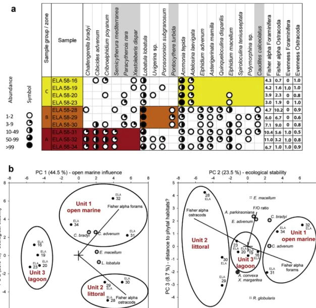
Fig. 6 Microfossil content in context of the transgressive contact. ... 123
Fig. 7 Breakwater construction in Hellenistic times. ... 124
Fig. 8 Modelled RSL-curve for the Bay of Elaia. ... 126
Fig. 9 Modelled RSL-curve for the Bay of Elaia compared to other curves for the Aegean region. ... 128
Fig. 10 The closed harbour basin of Elaia. ... 131
Fig. 11 Results of the geoseismic profile 7. ... 134
Fig. 12 Synoptic chronology of different approaches to detect the shift from shallow-marine conditions to lagoonal ones in the closed harbour basin as a result of the construction of its breakwaters. ... 135
Fig. 13 Modelled water depths in the closed harbour basin of Elaia for the past 8000 years. ... 139
Fig. 14 Modelled water depths in the open harbour area of Elaia for the past 8000 years. ... 140
Fig. 15 Detailed view on the water depths ... 142
Fig. 16 Geographic distribution of Peridinium ponticum. ... 146
Fig. 17 Selection of carved bones out of coring Ela 58. ... 146
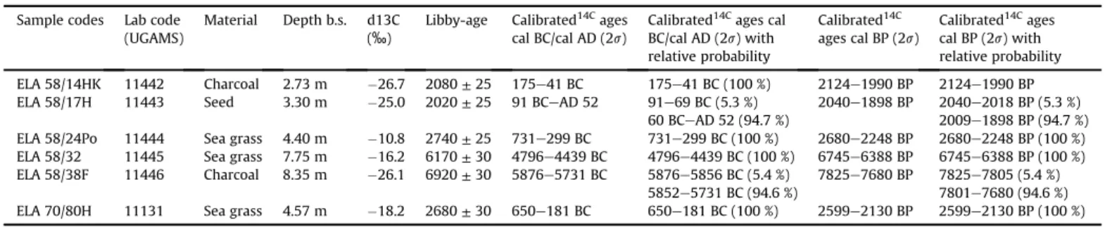
Tab. 1 Radiocarbon data sheet. ... 163
Chapter 1
Chapter 1
1 Introduction
1.1 Eastern Mediterranean coastal areas in the focus of geoarchaeological re- search
Around 6000 BC at the “dawn of civilisations” (Lambeck & Purcell, 2007), the major part of the Holocene marine transgression had nearly ended and a more or less stable sea level enabled societies to settle the Mediterranean coasts (Murray-Wallace & Woodroofe, 2014, Khan et al., 2015). During the following millennia, a seaside location was an important factor in establishing a flourishing settlement for many civilisations and harbour sites acted as important hubs for trade, travel and traffic. Nevertheless, the sea always showed an ambivalent character to hu- mans and their coastal settlements. In contrast to cities located in the hinterland, harbour settlements were exposed to risks from the sea, such as sea-level fluctuations and extreme wave events (storms, tsunamis). Additionally, harbours were also prone to siltation by fluvial or collu- vial sediment inputs. In the worst cases, this led to the abandonment of a city (Knoblauch, 1981;
Marriner & Morhange, 2007; Morhange & Marriner, 2010).
Various examples from the eastern Mediterranean region are known where shifting shorelines and changing sea level influenced the rise and decline of ancient settlements and their harbours.
Beginning with the Neolithic settlements of the Çukuriçi Höyük near ancient Ephesus (Horejs, 2012; Horejs et al., 2015; Stock et al., 2015), Hoca Çeşme in Thrace (Başaran, 2010; Özbek 2010) and Hamaylıtarla on the Gallipoli peninsula (Özbek, 2010) to the prominent ancient cities like Caesarea (Reinhardt & Raban, 1999), Tyre (Marriner & Morhange, 2006a), Corinth (Morhange et al., 2012; Hadler, 2014), Miletus (Müllenhoff, 2005; Brückner et al., 2006, 2013), Ephesus (Kraft et al., 1977, 2007; Brückner et al., 2013; Delile et al., 2015; Stock, 2015), Ainos (Başaran, 2010; Brückner et al., 2015), Yenikapı/Istanbul (Bony et al., 2012) and Troia (Kraft et al., 1980, 2003), just to name a few. Additionally, a vivid overview of recent ancient harbour research is published by Ladstätter et al. (2015).
No previous geoarchaeological studies have been conducted in the Bay of Elaia. This research is therefore timely and pioneering. It is important in helping to understand, why and when ancient settlements rose, flourished and decayed in the Mediterranean region.
Chapter 1
1.2 Aims of the study
The DAI (German Archaeological Institute) has been excavating the ancient city of Pergamon for more than 100 years. The scientific scope was widened to include the city of Pergamon and its environs, within the framework of the DFG priority program (SPP) 1209 "The Hellenistic Polis as a Living Space – Urban Structures and Civic Identity between Tradition and Innovation", which started in 2006. Thus, Elaia, the harbour city of Pergamon, and Atarneus, an important pre-Hel- lenistic predecessor settlement of the region, came into focus (Schneider et al., 2013, 2014, 2015; Pirson, 2014; Pirson & Zimmermann, 2015, Pirson et al., 2015; Zimmermann et al., 2015).
Except for small, sporadic archaeological field observations in the 20th century, travel reports in the early 19th century (cf. Prokesch von Osten, 1837) and ancient sources, not much was known about the Elaia region before the interdisciplinary fieldwork started. Several questions arose during the studies of Pergamon’s “maritime satellite” (Pirson, 2004), mostly focusing on human- environment interactions, shoreline displacements and the usability and history of the three different harbour sites of the city. Geoarchaeological methods were applied to solve these ques- tions. Three working hypotheses, including five research goals, form the basis for a final presentation of human-environment interaction in the Elaia region during the last millennia.
Working hypothesis 1: Coastal evolution, shoreline displacements and sea-level fluctuations in the Bay of Elaia.
In the Bay of Elaia, the peak of the postglacial marine transgression reached much fur- ther inland than today. Thereafter, alluvial and colluvial sedimentation caused a major seaward shift in the shoreline.
Goal 1: Determining the spatial and temporal dimensions of coastline changes during the past millennia.
No investigation dealing with this topic had been conducted in the Bay of Elaia. Results from other studies at the Aegean coast demonstrated that, in the course of the postgla- cial transgression, marine embayments extended far inland, later filled by alluvial sediments. Studies in Miletus (Kraft et al., 1977; Müllenhoff, 2005; Brückner et al., 2006), Ephesus (Kraft et al., 1977, 2007; Brückner, 2005; Stock 2015), Troia (Kraft et al., 1980), and Ainos (Alpar, 2001; Brückner et al., 2015) act as valuable examples. The shoreline displacements in the Bay of Elaia and the adjacent Bergama Graben are dis- cussed.
Chapter 1
Goal 2: Establishing a regional sea-level curve based on RSL indicators for the Bay of Elaia and discussing it within a wider Aegean context.
Like the shoreline displacements, sea-level fluctuations in the Bay of Elaia were still un- known. A robust regional sea-level curve (RSL-curve) is established by choosing reliable sea-level indicators and comparing them to other studies of the Aegean Sea and the modelled curve by Lambeck (1996) and Lambeck & Purcell (2005).
Working hypothesis 2: Elaia’s different harbour sites during the period of prosperity
During its period of prosperity, the city of Elaia successfully operated several harbours, which can be elucidated using geoarchaeological evidence
Goal 1: Describing the lifecycle of the closed harbour basin of Elaia.
The closed harbour basin is of special research interest being the only visible ancient remain in Elaia, and incorporated into the Hellenistic city walls. Here, the lifecycle of the closed harbour basin, from its foundation up to its abandonment, is described. A special focus is the construction date of the harbour’s breakwaters, which is detectable by sev- eral architectural, literary and geoscientific methods.
Goal 2: Determining the water depths of Elaia’s harbours and their accessibility by dif- ferent ship classes during Hellenistic and Roman times.
This chapter solves the question concerning when and which ship classes were able to reach the closed harbour basin and the open harbour area of Elaia. Estimation of the water depths in the two areas are compared to the draughts of common ships of those periods.
Working hypothesis 3: Human impacts in the Bay of Elaia over the past millennia
The temporal changes and the intensity of human impact on the environment can be elucidated by geoarchaeological research.
Main goal: To identify and quantify human impacts on the Bay of Elaia over the millen- nia.
As economic centres and points for naval navigation, ancient harbour cities are of par- ticular geoarchaeological interest. The combination of all information gained by interdisciplinary research helps to reconstruct multi-temporal landscape scenarios (Morhange et al., 2014). In this chapter, the human impact on the landscape caused by the Elaïtans is presented chronologically.
Chapter 1
1.3 General approach
In closing the gap between physical geography, natural sciences, and archaeology by integrating methods of all three disciplines, geoarcheology acts as an interesting toolbox to reconstruct changes in the palaeo-landscape and to detect human impact on it (Rapp & Hill, 2006). A modi- fied version of the geoarchaeological approach of Brückner & Gerlach (2011) is used in this dissertation, which is mainly based on the investigation of geo-bio-archives (Fig. 1).
Fig. 1 Study design following Brückner & Gerlach (2011), modified.
Chapter 1
The Bay of Elaia presents several geo-bio-achieves such as coastal wetlands, near-shore sedi- ments, a coastal spit, alluvial fans, and harbour sediments. Between 2008 and 2012 these archives were studied using terrestrial and semi aquatic vibracorings (Atlas Copco Cobra TT) and geophysical exploration (geoelectric (ERT), geomagnetic and geoseismic). All coring and geo- physics sites were levelled using DGPS (Leica DGPS System 530).
The sediments were investigated using sedimentological, geochemical, and microfaunal tools.
Statistically evaluated, this allows the interpretation of different sedimentary environments (shallow marine, littoral, limnic, lagoonal, colluvial etc.). In addition, palynological and archaeo- botanical analyses enable the determination of the palaeovegetation. Robust chronostratigraphies of the sediment sequences were established by radiocarbon (14C) and op- tically stimulated luminescence (OSL) dating as well as archaeological dating of artefacts. The combination of this information, coupled with information from the archaeological record, al- lows to resolve the questions outlined above, to reconstruct landscape changes, and to decipher human-environment interactions over the last millennia.
This dissertation includes five publications (Chapters 2–6) concerning different aspects of the geoarchaeological research in Elaia with a special focus on coastal changes, the identification and investigation of Elaia’s harbour sites, and human-environment interactions. The following describes the main focus of each paper.
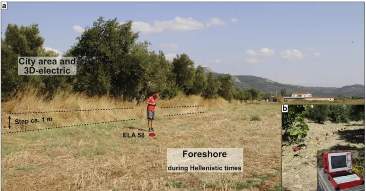
Chapter 2 deals with the closed harbour basin of Elaia. Nowadays, it is completely silted up and it is hard to imagine that ships once anchored here. Drilling cores inside and outside the harbour basin were investigated by means of geochemistry and sedimentology to decipher the history of the basin and its surroundings. The lifecycle of the harbour is described. In addition, an ERT profile and a coring were performed directly at the closed harbour’s western breakwater to de- cipher its construction style and age.
Chapter 3 focuses on the open harbour area of Elaia. Archaeological research in Elaia suggested the need for ship sheds to store and maintain the valuable warships when not in action. From an archaeological point of view, the area between the closed harbour basin to the west and the so-called diateichisma – an internal city wall – to the east seemed to be the most appropriate location for such installations. This is supported by geomagnetic interpretations (Pirson, 2010).
Therefore, 3D-geoelectric measurements in this area were conducted to estimate the extension and shape of the supposed buildings. In addition, 2D-geoelectric profiles in front of the assumed ship sheds heading towards the sea were carried out. One sediment core was recovered directly
Chapter 1
in front of the assumed ships sheds and analysed in detail with regards to its geochemical, sed- imentological, and microfaunal characteristics. Altogether, five radiocarbon ages were used to establish a robust chronology for the profile. In addition to the coring, surficial sampling of dif- ferent contemporary environments of the study area was performed to establish a present-day referential for the microfauna. This allows for estimating water depths of the area for the pros- perous periods of Elaia and solves the question of whether the assumed ship sheds could be accessed by ship.
Chapter 4 links and widens the topic of shoreline displacements and possible harbour sites by integrating the results of Chapters 2 and 3 into a broader framework of five intensively-studied core transects covering the entire study area. This allows for determining the spatial and tem- poral extension of the marine trans- and regression as well as the verification of the beach harbour area as a third harbour site of Elaia.
In contrast to Chapters 2-4, Chapter 5 focuses on the age and function of submerged wall struc- tures in the western part of the embayment. Today, their upper surface is 0.5–1.0 m below present sea level. The subsoil of the walls and the construction style were investigated by semi- aquatic coring and water-borne geoelectrics, while further corings inside and outside the wall structures yielded material for radiocarbon dating. Additionally, sediments directly below the brickworks were dated by OSL to estimate the burial age and indirectly date the construction of the walls.
Chapter 6 deals with the reconstruction of the vegetation and environmental history of the wider Bay of Elaia since 7500 BP. Therefore, coring Ela 70 out of the closed harbour basin of Elaia was investigated by means of palynology and archaeobotany. A total of 11 radiocarbon ages provided a detailed age-depth model.
Finally, Chapter 7 discusses the results of the conducted research with a focus on the working hypotheses of Chapter 1.2, followed by a conclusion (Chapter 8).
Chapter 1
1.4 Study area
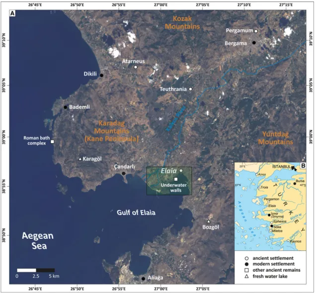
Elaia is situated on the northern Aegean coast of modern Turkey (Fig. 2). In sum, two large-scale landscape-forming processes have affected the contemporary appearance of the area.
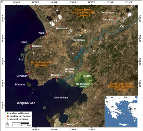
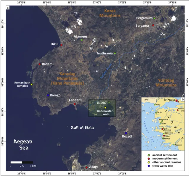
Fig. 2 The area of research at the Aegean coast of Turkey. (a) Landsat 8 satellite image (acquired 23 Septem- ber 2013; RBG composite based on bands 4, 3, 1), with locations mentioned in the text. Insert: (b) General map the Aegean Sea with position of the research area.
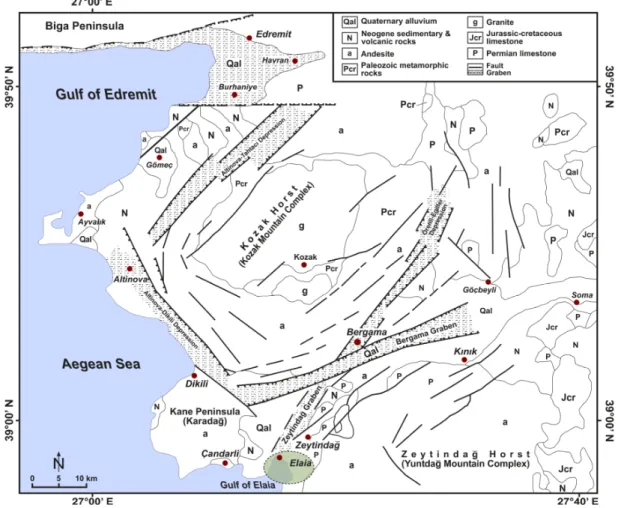
The study area is part of the westwards moving Aegean-Anatolian microplate (Brückner et al., 2010; Vacchi et al., 2014). With its westward drift, several rift structures formed during Miocene to Pliocene times, such as the Bergama Graben and its tributary Zeytindağ Graben (Fig. 3, Demirci et al., 2015). Some of them act as outlet channels for rivers today, such as the Büyük and Küçük Menderes and the Bakırçay (Vita-Finzi, 1969; Aksu et al., 1987; Özürlan et al., 2006).
The Bergama Graben is still tectonically active. This is evident from submerged archaeological remains: (i) a Roman thermal bath complex (Bademli Ilıca) on Kane Peninsula; and (ii) underwa- ter wall structures in the southwestern Bay of Elaia (Chapter 5). Additionally, Schneider (2014) provides a clear overview of more or less destructive historic earthquakes affecting the area from Roman Imperial times onwards (Garbrecht, 2003; Emre et al., 2005; Schneider, 2014).
Chapter 1
Fig. 3 Structural map of the research area and the surrounding mountain ranges. Source: Altunkaynak &
Yılmaz (1998), modified.
Because of the tectonic stress, the second landscape-building agent – volcanism – started to affect the area. This is obvious in the occurrence of massive andesite layers, which covered the older Palaeozoic-Mesozoic granites of the Yuntdağ and Kozak Mountains. In addition, the land- scape is littered with volcanic domes of which the Karadağ (755 m a.s.l., above sea level) and Teuthrania1 (115 m a.s.l.) are the most prominent ones (Altunkaynak & Yilmaz, 1998; Radt, 2011).
Taking a closer look at the research area, the Kane Peninsula (Karadağ) to the west and the Yuntdağ Mountains to the east surround the Gulf of Elaia and the inner part of the Bay of Elaia.
The wide alluvial plain and the cuspate delta of the Bakırçay (ancient name: Kaikos) are located to the west of the Bay of Elaia, separated by the relatively flat ridge of Bozyertepe (40 m a.s.l.).
Wetlands consisting of pioneering Salicornia plants are observed south of Bozyertepe.
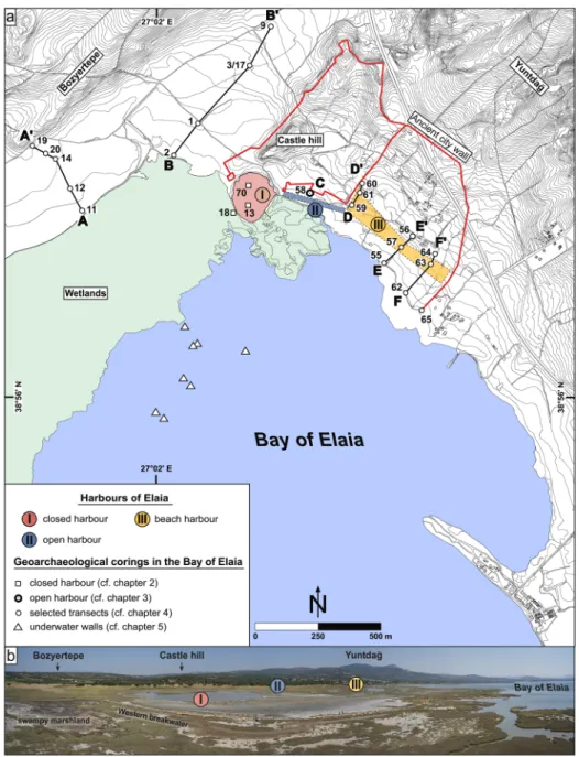
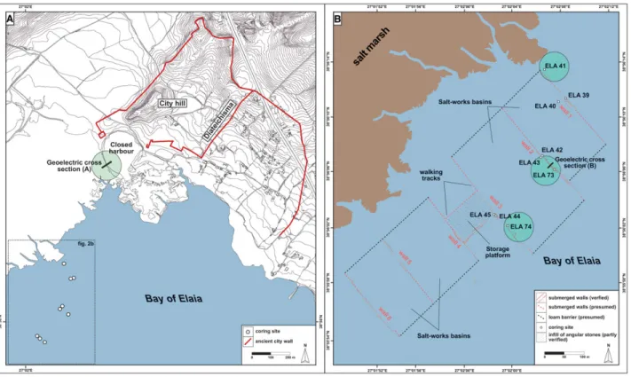
The research area, with its three harbour sites, is situated in the inner part of the Bay of Elaia adjacent to the castle hill and the ancient city area (Fig. 4).
1 The mythical place where Telephos, the legendary founder of Pergamon, is said to has once lived.
Chapter 1
Fig. 4 Locations of selected vibracores carried out in the Bay of Elaia. (a) Locations of coring transects A–A’, B–B’, D–D’, E–E’ and F–F’, and C (coring Ela 58). (b) Panoramic overview of the area of research (UAV image;
taken on 01 September 2015 by Andreas Bolten).
The three harbour sites are: Firstly, the closed harbour basin which is incorporated within the fortification walls of the city. It was protected against the sea and enemies by two presently drowned breakwaters, one to the southeast and one to the west. Because the breakwaters are the most prominent ancient remains in the area, this closed harbour basin is of special interest (Chapters 2 & 6). Secondly, the ca. 250 m-long open harbour, stretched from the southern breakwater of the closed harbour south-eastwards to the point where the diateichisma reached the waterfront (Chapter 3). This wall divided the city area into a northern, densely populated part and a southern one (Pirson, 2011). Thirdly, an open beach harbour extended from the south
Chapter 1
of the diateichisma to the south-eastern end of the city wall (Chapter 4, Pirson 2011). Sub- merged wall structures are situated southwest of the closed harbour in the shallow water of the embayment (Chapter 5).
1.5 History of Elaia
The historical evolution of Pergamon and Elaia is closely interwoven. Therefore, this chapter briefly focuses on the history of Elaia and its relationship to Pergamon (Fig. 5). It relies largely on the work of McShane (1964), Hansen (1971), Pirson (2004), Radt (2011), Zimmermann (2011), Pirson (2014), Pirson et al. (2015), Gehrke (2015) and Pirson & Zimmerman (2015).
Fig. 5 Timeline of the historic periods, linked with Elaia’s most flourishing period.
The settlement of Elaia is most probably of pre-Greek origin. Mythical sources date its founda- tion back to the times of the Trojan War and the legendary Telephos of Pergamon (Pausanias2, Graeciae descriptio 9, 5, 14). Nevertheless, some finds dating to the early Bronze Age, as well as late Helladic and Mycenaean ceramics at the castle hill of Elaia also suggest initial settlement activities during these early periods (Pirson et al., 2015).
Historically, Elaia is first mentioned in early Classical times in the tributary lists of the Attic-Delian League (5th century BC), but payed the modest contribution of only 1/6 talent during 454–
425 BC. In addition, Herodot3 (Historíai 1, 149) did not include Elaia in his summary of altogether 12 Aeolian settlements. This suggests a relatively small settlement during this period (Pirson &
Zimmermann, 2015; Pirson et al., 2015).
The entire Kaikos region came under Macedonian rule through the military campaign by Alex- ander the Great, until the so-called “Wars of the Diadochi” started soon after his death in Babylon in 323 BC (Cartledge, 2004). The house of the Attalids came to power in the Kaikos re- gion at an advanced stage of this turmoil and established – in alliance with Rome – a powerful kingdom in Asia Minor. During its most flourishing period under King Eumenes II (197–159 BC), it ruled the western half of present-day Turkey. Pergamon itself was located on top of a 330 m-
2 Pausanias; Greek travel writer and geographer; ca. AD 115–180.
3 Herodot; Greek geographer, historian and ethnologist; ca. 490/480–424 BC.
Chapter 1
high castle hill, controlling the adjacent Kaikos plain (Fig. 2a). This was an excellent strategic po- sition, but complicated trade and transport. For economic and military reasons the city needed a maritime harbour, which was obtained by integrating the nearby city of Elaia, located on the Aegean Sea approx. 26 km southwest of Pergamon, into their realm. It is assumed that Elaia came under Pergamenian rule between 246 and 241 BC during the reign of King Eumenes I.
Hereafter, the relationship between Pergamon and Elaia can be described as an interaction of taxation and subvention of the Pergamenian kings with a simultaneous autonomy of the Elaïtans (Pirson et al., 2015).
Elaia was fortified and used as the harbour city of Pergamon, which became evident in Strabo’s4
“Geographika”, where he mentioned Elaia as the naval base (naustathmon) of the Attalids and the harbour city (epineion) of the Pergamenians (13, 3, 5). Direct evidence for the importance of the harbour is given, e.g., in Livius’s5 “Ab urbe condita” when a Pergamenian fleet of 35 Quin- quereme (Pentere) ships, largely based in Elaia, jointly took part with Rome in the First Macedonian War (215-205 BC). In addition, Polybios6 (Historíai 21, 10) and Livius (Ab urbe con- dita 28, 5, 1) mentioned large Roman, Rhodesian and Pergamenian naval units stationed in Elaia during the Roman-Syrian War (192–188 BC).
Furthermore, the city did not only serve as the main harbour of Pergamon. A narrow passage was left between the slopes of the Yuntdağ Mountains and the eastern city district, easily con- trolled by the military garrison of Elaia (Figs. 2 & 4). Therefore, Elaia was also a defensive stronghold, which secured the southern entrance to the inner realm of the Kaikos area and the nearby coastal road heading southwards to Smyrna (Pirson, 2008, 2014; Seeliger et al., 2013;
Pirson & Zimmermann, 2015). This topographic setting is quite similar to the one at Thermopy- lae in central Greece where, in 480 BC, the legendary 300 Spartans were able to withstand a far larger Persian army during a long battle (Kraft et al., 1987). In combination with the importance of Elaia in the economic network of Pergamon, it certainly seems to be legitimate to refer to Elaia as the “maritime satellite” of Pergamon (Pirson, 2004; Pirson & Zimmermann, 2015).
A gradual loss in the importance of the city of Elaia became obvious with its incorporation into the Roman world from 133 BC onwards (Pirson, 2004). This was most probably caused by the ongoing siltation of the harbour area of Elaia. The literary and archaeological evidence for the post-Attalid period is as poor as for the pre-Attalid one. Since the 6th/7th century AD the city was abandoned.
4 Strabo; Greek geographer; ca. 63 BC–AD 23.
5 Livius; Roman historian; ca. 59 BC–AD 17.
6 Polybios; Greek historian; ca. 200–120 BC.
Chapter 2
Chapter 2
2 Taken from the sea, reclaimed by the sea: The fate of the closed harbour of Elaia, the maritime satellite city of Pergamum (Turkey)
Journal Article (2013):
Seeliger, M., Bartz, M., Erkul, E., Feuser, E., Kelterbaum, K., Klein, C., Pirson, F., Vött, A., Brückner, H., 2013. Taken from the sea, reclaimed by the sea: The fate of the closed harbour of Elaia, the maritime satellite city of Pergamum (Turkey). Quaternary Interna- tional 312, 70–83.
Taken from the sea, reclaimed by the sea: The fate of the closed harbour of Elaia, the maritime satellite city of Pergamum (Turkey)
Martin Seeligera,*, Melanie Bartza, Ercan Erkulb, Stefan Feuserc, Daniel Kelterbauma, Christina Kleinb, Felix Pirsond, Andreas Vötte, Helmut Brücknera,*
aInstitute for Geography, University of Cologne, Albertus-Magnus-Platz, 50923 Köln (Cologne), Germany
bInstitute of Geosciences, University of Kiel, Otto-Hahn-Platz 1, 24118 Kiel, Germany
cHeinrich Schliemann-Institute for Ancient Studies, University Rostock, 18051 Rostock, Germany
dGerman Archaeological Institute (DAI),_Inönü Caddesi 10, 34437_Istanbul, Turkey
eInstitute for Geography, Johannes Gutenberg-Universität Mainz, Johann-Joachim-Becher-Weg 21, 55099 Mainz, Germany
a r t i c l e i n f o
Article history:
Available online 14 March 2013
a b s t r a c t
During Hellenistic times, when the Pergamenian kingdom was prospering, Pergamum was operating an important harbour, used by merchants and military at the city of Elaia. This paper focuses on the development, utilisation and decay of the closed harbour of Elaia, which is discussed in the context of the landscape evolution of the environs of the ancient settlement. Based on geoarchaeological, archaeo- logical and literary evidence, the construction of two harbour moles in order to provide shelter against wave action and enemies can be attributed to the early Hellenistic period. Geoelectric measurements revealed the construction profile of the moles. Coring evidence indicated that together with mole con- struction, a greater area of the formerly shallow marine and sublittoral terrain was consolidated, most probably to create space for harbour installations. The closed harbour basin was used intensely during Hellenistic and Roman times. Later, continued siltation hindered further usage. In combination with the decline of the city of Elaia in Late Antiquity, this was the reason why the harbour was abandoned.
Scenarios for the time of the maximum transgression of the sea around 2500 BC, the early Hellenistic times around 300 BC, and Late Antiquity AD 500, are presented.
Ó2013 Elsevier Ltd and INQUA. All rights reserved.
1. Introduction
Many multidisciplinary studies have focused on ancient har- bours along the Mediterranean coasts throughout the last decade:
the Great Harbour of Ephesus (Kraft et al., 2000,2007), the harbour of Tyre (Marriner and Morhange, 2006b; Marriner et al., 2007;
Morhange et al., 2012), the seaport of Oiniadai (Vött et al., 2007), the harbour of Luni (Bini et al., 2009), the western harbour of Corinth (Morhange et al., 2012), Herod the Great’s harbour at Caesarea (Reinhardt and Raban, 1999), and the harbour of Carthage (Gifford et al., 1992), just to mention a few. The importance of the topic is underlined by the fact that in August 2012 the German Research Foundation launched a priority programme to further investigate ancient harbours from Roman Imperial to Medieval times (DFG-SPP 1630).
This paper presents the results of thefirst geomorphological, geoarchaeological, geophysical, and geochronological research on
the closed harbour of the ancient city of Elaia, which was also Pergamum’s principal marine harbour. Its basin is situated at the foot of the city hill in the central northern part of the Gulf of Elaia (Figs. 1 and 2). The harbour was built during Hellenistic times ac- cording to historical sources and archaeological evidence. It is the only still visible ruin of Elaia, although it has almost completely been silted up with marine, alluvial and colluvial deposits (Fig. 3).
The main objectives of this study are: (i) to investigate the siltation process of the closed harbour of Elaia in space and time; (ii) to compare this process within and around the harbour basin; and (iii) to provide a chronological framework for the construction of the moles from a geoarchaeological point of view.
2. Study area
2.1. Physical setting
The Bay of Elaia is the innermost part of the Gulf of Elaia (modern name: Gulf of Çandarlı). It is located between the Yuntdag mountain complex to the east and the Karadag mountain complex
*Corresponding authors.
E-mail addresses:martin.seeliger@uni-koeln.de(M. Seeliger),h.brueckner@uni- koeln.de(H. Brückner).
Contents lists available atSciVerse ScienceDirect
Quaternary International
j o u r n a l h o m e p a g e : w w w . e l s e v i e r . c o m/ l o ca t e / q u a i n t
1040-6182/$esee front matterÓ2013 Elsevier Ltd and INQUA. All rights reserved.
http://dx.doi.org/10.1016/j.quaint.2013.03.004
on Kane Peninsula to the west (Figs.1a and2). The Kaikos River (modern Bakır Çay) debouches into the Aegean Sea between the Kane Peninsula and the Bay of Elaia by forming a cuspate delta. The slopes of the Yuntdag Mountains border the swampy coastal plain to the east and to the north. The latter and the Bay of Elaia are very flat with a seafloor gradient approximating 0.5% (Aksu et al., 1987).
A mean tidal range ofw20 cm was inferred for the Bay of Elaia by DGPS. This value is in good agreement with studies from similar embayments in the Eastern Mediterranean (Flemming, 1978;
Anzidei et al., 2011). The innermost part of the gulf is protected from stronger wave action, even during winter storms, due to its sheltered position.
The Yuntdag and Kozak mountain ranges consist of Palaeozoice Mesozoic granites. The Bay of Elaia is part of the Aegean-Anatolian microplate. With the westward drift of the Anatolian Plate, several EeW oriented rift structures were formed in the late Miocene, such as the Bergama graben, and its tributary, the Zeytindag graben (Fig. 2). This tectonic ensemble represents a fractured zone which was favourable for the evolution of the Kaikos valley (Vita-Finzi, 1969; Brinkmann, 1976;Aksu et al., 1987; McHugh et al., 2006).
The ongoing subsidence is evident from drowned archaeological remains: (i) a Roman thermal bath complex on Kane Peninsula
(Fig. 1a); and (ii) underwater wall structures in the south-western Bay of Elaia, probably dating to Late Roman times (Fig. 4a) (Seeliger et al., 2012).
2.2. Historical and archaeological background
The Pergamenian kingdom was highly influential in Asia Minor during Antiquity. Pergamum, its capital city, is often mentioned in contemporary sources together with other important cities including Troy (Troia) and Miletus (Fig. 1b). To date, the city is known for its unique archaeologicalfinds, among others the Per- gamum Altar, and for Aelius Galenus, one of the most famous physicians of ancient times (Radt, 1999;Cimak, 2009).
Following the Wars of the Diadochi after Alexander the Great’s death in 323 BC, the House of the Attalids came to power in the Kaikos region until 133 BC. Under the reign of Eumenes II (197e159 BC), the Attalids governed the whole western part of modern Turkey (Hansen, 1971;Radt, 1999;Cartledge, 2004;Pirson, 2008;
Cimak, 2009).
The 330 m high city hill of Pergamum dominating the sur- rounding Kaikos plain provided a strategic location for the foun- dation of a new city. Access to the Mediterranean Sea for traffic and Fig. 1.Research area at the Aegean coast of Turkey. (a) Overview based on Landsat ETMþ2005 with locations mentioned in the text; (b) General map of western Turkey with a selection of ancient and modern settlements.
M. Seeliger et al. / Quaternary International 312 (2013) 70e83 71
trade was provided through the acquisition of nearby Elaia, situated at the Aegean coast 26 km southwest of Pergamum, under Eumenes I (reign: 263e241 BC) (Radt, 1999;Pirson, 2004;Cimak, 2009). Strabo identified Elaia as the commercial harbour of the Pergamenians and as the military base of the Attalids (Strabo (2005), Geographica XIII, 1, 67 and XIII, 3, 5). Further literary evi- dence as well as archaeologicalfindings confirm the relations be- tween Elaia and Pergamum (Pirson, 2004,2009).
Thus, Elaia was Pergamum’s key portal to the Aegean Sea with regards to traffic, trading, and military actions, although also other naval bases existed, e.g. on the Island of Aegina. By the end of the 3rd century BC, Pergamum’s navy encompassed at least 35 war- ships in the category of the so-called“fives”(quinqueremes) (Pirson, 2004). This is quite a smallfleet as compared to coexisting naval bases of other poleis, e.g. on the Island of Rhodes or in Piraeus; it explains Pergamum’s need for other bases (Pirson, 2004).
In the Archaic and Classical period, Elaia was of only minor importance: Herodotus does not mention the city in his list of the twelve Aeolian cities (Herodotus (2001), Historia I, 149). In the tributary lists of the Attic Delian League between 454 and 425 BC, it is quoted with a very low toll of 1/6 talent. Pergamum, and as a consequence Elaia as well, gradually lost their significance when Ephesus was nominated the capital of the Roman province of Asia in the 1st century BC (Pirson, 2004, 2008). Thus, Elaia’s most
prosperous time was clearly confined to the Hellenistic era when the city was under the rule of Pergamum (Pirson, 2008; Cimak, 2009).
A major outcome of the ongoing large-scale ceramic survey was that during Archaic and Classical times the settlement of Elaia was restricted to the central city hill, which is located northeast of the closed harbour (Figs. 3and4), and had continuously been settled since the Bronze Age (Pirson, 2010). The situation changed during Hellenistic and Roman times, when many areas surrounding the city hill were settled as well. The fortification wall and an internal wall (diateichisma) were erected in the Hellenistic period. The diateichismadivided the city into a densely populated area in the northwest around the central city hill and the closed harbour, and a sparsely inhabited area in the southeast. During Late Antiquity, the population of Elaia shrank and was contained within the bound- aries of the city hill. Finally, the city was abandoned between the 6th and the 7th century AD (Pirson, 2010).
In addition to its maritime and economic relevance, Elaia played an important strategic role in securing the southern entrance to the Kaikos plain which was the main land of the Pergamenian kingdom. As the foothills of the Yuntdag mountains reach the sea by creating a steep slope, there is only a narrow passage north of Yeni S¸akran (Fig. 1a) that could easily be controlled by the Perga- menian forces based in Elaia (Pirson, 2004). The topographic Fig. 2.Structural map of the research area and the surrounding mountain ranges. Source:Altunkaynak and Yılmaz (1998), slightly modified.
situation is slightly comparable to that at Thermopylae in Greece (Kraft et al., 1987): a narrow passageflanked by high mountains on the one side and the sea on the other.
Located 18 m higher than the coastal plain, the city hill of Elaia played an important role, at least from the archaeological point of view, as it hosted the major settlement centre from the Bronze Age up to the abandonment of the city in the 6th/7th century AD. The closed harbour basin is located to the southwest of this hill (Figs.3b and4a). This harbour was protected against wave action by two moles, a southern one and a western one. The upper section of the western mole can still be seen above the ground. It is constructed from ashlar masonry made of yellowish calcareous sandstone blocks up to 1.70 m0.80 m0.40 m each. Only the cap of the mole which was always above sea level is visible. Its basement most likely consists of an embankment of dumped rubble and rocks. As soon as this artificial structure had reached the sea surface, the ashlar wall was built on top of it, up to an original height of at least 2 m above the palaeo-sea level. The second mole in the southeast of the harbour basin was detected in the geophysical survey, and its construction style must have been of the same kind (Pirson, 2004, 2010).
The closed harbour was most likely incorporated into the forti- fication wall of Elaia. The basin had a length of about 200 m from east to west and about 250 m from north to the south; it encom- passed an area of approximately 4.8 ha. The seaward entrance was some 45 m wide, and located in the south of the harbour basin, protected from the prevailing western winds (Pirson, 2004,2008).
The building techniques of the western mole with ashlars joint together by wooden dovetail cramps (Fig. 3d) as well as lack ofopus caementitium(Roman concrete) as building material date the mole to pre-Roman times.Opus caementitium was introduced to Asia Minor not before the middle of the 1st century BC (Ganzert et al., 1984;Waelkens, 1987). As written sources state, Elaia was only of minor importance in the Archaic and Classical periods, as confirmed by the archaeological survey (Pirson, 2010). Therefore, Elaia could not have implemented such a building programme
during those centuries. This leads to the conclusion that the harbour basin with its two moles was most probably constructed in Hellenistic times.
3. Methods
The detailed study of lateral and vertical changes of sedimentary facies from nearshore sediments is a well-established approach to reconstruct palaeoenvironmental variations during the Holocene.
To date, 78 terrestrial and semi-aquatic cores have been taken in the area since 2008 to decipher the palaeogeographic evolution and, in particular, to detect coastline changes. This article focuses on three vibracores drilled inside and adjacent to the closed harbour basin of Elaia.
Drilling was done with an Atlas Copco Cobra mk1 vibracorer (Fig. 3b). Closed steel auger heads with 1 m PVC inliner tubes (external diameter: 50 mm) were used for coring ELA 70, while cores ELA 13 and ELA 18 were performed with open steel auger heads (diameters of 60 and 50 mm, respectively). Preliminary sedimentological studies were carried out directly in the field, including grain size, colour (Munsell Soil Color Charts), texture, roundness, and carbonate content (10% HCl) (AG Boden, 2005). Bulk samples for laboratory analyses, as well as macrofossils and ceramic fragments for a later determination were taken from open sedi- ment cores. All coring sites were levelled with DGPS (Leica GPS System 530; lateral and vertical resolution of2 cm). The altitude above sea level is based on the local reference system PergSys05, established by the German excavation team of Pergamum in 2005;
the values have to be height-corrected by0.875 m due to an in- accuracy of the reference system (Seeliger et al., 2012).
In the laboratory the sediment samples were air-dried, ground, and sieved to separate the matrix material <2 mm for further analyses. The granulometry was measured with a laser particle sizer (Beckman Coulter LS13320) after the removal of the organic content with H2O2. For the calculation of grain-size parameters after Folk and Ward (1957), the GRADISTAT software (Blott and Fig. 3.The closed harbour of Elaia. (a) Overview from the top of the city hill; (b) Location of coring site ELA 70 inside the harbour basin; (c) Western mole with location of coring site ELA 18 outside the harbour basin; (d) Recess for the former wooden dovetail cramp on top of the mole. Photographs: Bartz and Seeliger (2010, 2011).
M. Seeliger et al. / Quaternary International 312 (2013) 70e83 73
Pye, 2001) was applied. Carbonate content was measured by a Scheibler device. The loss on ignition (LOI) was determined by oven-drying the samples at 105 C for 12 h, and ignition in an annealing furnace at 550C for 4 h (Beck et al., 1995). The accuracy of the LOI parameter is widely discussed because two chemical processes may cause errors (Mook and Hosin, 1982;Heiri et al., 2001; Barillé-Boyer et al., 2003): the possible loss of CO2 from carbonates consisting of inorganic material (Salehi et al., 2011), and the loss of structural water from clay minerals (Dankers and Laane, 1983). Both result in weight reduction not caused by loss of organic matter. A subsequent correction of the LOI values was not done in this study.
Measurements of the electrical conductivity were performed in an aqueous solution consisting of 15 g of sediment and 75 ml distilled water with a glass electrode (Mettler Toledo InLabÒ731- 2m) (Beck et al., 1995).
A portable XRF spectrometer (Niton Xl3t 900 GOLDD) was used to determine total amounts of 25 elements with a vertical resolu- tion of several decimetres (in cases of ELA 13 and 18) and 5 cm (ELA 70), respectively. Sodium (Na), an indicator for marine environ- ments, is not detected with this XRF technique; it was measured by
using atomic absorption spectrometry (AAS; A-Analyst 300 by Perkin Elmer).
These multi-proxy geochemical and granulometric analyses were primarily carried out in order to support the facies determi- nation (cf.Ernst, 1970;Vött et al., 2002,2004;Brückner et al., 2005, 2006,2010a;Engel et al., 2009;Niwa et al., 2011).
Earth’s electrical resistivity was determined with the RESECS multi-electrode system in order to detect the thickness and shape of the central harbour pier of Elaia. On profiles with a length of 47 m and an electrode spacing of 1 m, measurements with several electrode configurations such as DipoleeDipole, Wenner and Schlumberger were done. The apparent electrical resistivity was determined as a function of the electrode geometry by the measuring instrument. Using the inversion software RESINV2D (Loke and Barker, 1995), the resistivity-depth distribution for each profile was inverted from thefield data.
14C-AMS age estimates based on wood, charcoal, seagrass, and marine gastropods were performed in the Center for Applied Isotope Studies (CAIS) of the University of Georgia at Athens (USA).
For calibration, the Calib 6.1.1 software was applied with a marine reservoir effect of 39085 years and aDR of 3570 years (Siani Fig. 4. Location of vibracores carried out in the Bay of Elaia 2008e2011. The maps are based on DGPS data levelled by the Pergamum excavation. (a) Synoptic view with the area of the city of Elaia; (b) Cores in the area of the so-called closed harbour; (c) Cores in the eastern part of Elaia.