Секция 6. Опасные береговые процессы
221
2. Предложения по генеральной схеме укрепления железнодорожной линии Туапсе – Адлер Северо- Кавказской железной дороги. М.: ЦНИИС, 1956.
3. Разработка рекомендаций по защите земляного полотна на перегоне Туапсе – Адлер (проект «Усиление линии Туапсе – Адлер»). Сочи: ОАО ЦНИИС НИЦ «Морские берега», 1999.
DESTRUCTION OF COASTS WITH TABULAR GROUND ICE OCCURRENCE ON KOLGUEV ISLAND, EUROPEAN RUSSIAN ARCTIC
F. Günther1,2,3, A.I. Kizyakov4, M.V. Zimin5, A.V. Sonyushkin6
1Institute of Geosciences, University of Potsdam, Potsdam, Germany
2Lab. Geoecology of the North, Faculty of Geography, Lomonosov Moscow State University, Moscow, Russia
3Dept. of Permafrost Research, Alfred Wegener Institute for Polar and Marine Research, Potsdam, Germany
4Dept. of Cryolithology & Glaciology, Faculty of Geography, Lomonosov Moscow State University, Moscow, Russia
5Research and Development Center ScanEx, Moscow, Russia
6OpenWeatherMap, Inc., NY, USA
Kolguev Island is the most western point in the Russian Arctic with tabular ground ice occurrence. Since the Barents Sea is characterized by strong sea ice decline, it is very interesting to study coastal dynamics in con- junction with cryogenic processes in this region. Destruction of arctic permafrost coasts occurs as a result of a complex suite of processes, predominantly thermal abrasion and denudation. Activation of these processes can be particularly observed in case of massive ground ice bodies (ice wedges or tabular ground ice) that become exposed on high bluffs along the coastline. Thermo-denudation of exposed ground ice includes ice ablation, thaw of enclosed frozen deposits and the development of retrogressive thaw slumps with thermo-cirque or thermo- terrace formation. Due to its high self-enforcing process intensity thermo-denudation can be referred to as one of the most hazardous processes of permafrost degradation. As a result of field and remote sensing data analysis, coastline classification and segmentation were done according to the morphodynamics principle. The following types are defined:
1) thermo-abrasion wave exposed cliffs,
2) thermo-abrasion with stabilized cliffs, bordered by beaches or accumulative terraces, 3) sheltered abrasion (thermo-abrasion) cliffs,
4) accumulating coasts and accumulative forms, 5) accumulated coasts with sheltered tidal flats, 6) deltas.
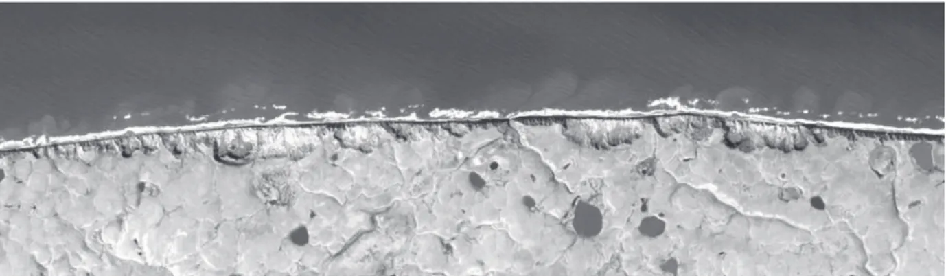
Thermo-abrasion cliff coasts are predominantly distributed in the west, north and northeast of the island, and accumulative shores in the south, southeast and east of the island (Fig. 1).
Fig. 1. High resolution Formosat satellite image of the northern coast of Kolguev Island (July 2012), showing numerous and closely spaced landward advancing retrogressive thaw slumps
Закономерности формирования и воздействия опасных явлений и катастроф
222
New data on thermal denudation and thermal abrasion rates for Kolguev Island have been obtained using a whole set of multi-temporal satellite images of high and very-high spatial resolution (GeoEye, WorldView, Alos Prism, SPOT, Formosat, RapidEye, Kompsat, and RESURS) covering the period from 2002 to 2017. For image orthorectification purposes, the 12 m TanDEM-X DEM has been used. However, since the TanDEM-X DEM is based on averaged bistatic SAR surveys acquired during the period 2010–2012. This DEM can be used only for orthorectification of images newer than 2012 to determine the exact coastal bluff position and thermocirque edges. We therefore reconstructed the relief along erosive coastline segments by modifying the initial TanDEM-X DEM through extrapolation of coastal bluff edge elevations and restoration of the coastal plain relief at 200–300 m towards the sea for orthorectification of images prior to 2012. All raw images were terrain-corrected and georeferenced using a comprehensive block adjustment, resulting in a very high absolute and relative accuracy of all images.
On the western coast of Kolguev Island, average coastal bluff retreat rates between 2002 and 2012 varied from 1.7 to 2.4 m/year. Within key-sites that included three large thermocirques maximum headwall retreat rates ranged from 1.9 to 15.1 m/year for 2002–2012 and 2.2–13.5 m/year for 2012–2017 yrs. In comparison, activation of thermo-denu- dation has been also noted along the Kara Sea coast where rates raised up to 13 m/year and were generally correlated with changing environmental factors, particularly expressed in an increase on the thaw index during recent years.
An impressive illustration of the accelerated erosional regime in the region, besides enhanced erosion rates, it is of particular note that even long-term accumulative forms in the southern part of Kolguev Island are now also being eroded. Thus, on Vostochnye Ploskie Koshki (on the south of the island), the retreat of formerly accumulative coasts from 2009 to 2016 in some areas amounted up to 62 m. This study on Kolguev Island continues and expands our earlier research efforts on coastal dynamics in the region [Kizyakov et al., 2013].
Acknowledgements
This study was supported by ERC grant #338335 PETA-CARB, German Academic Exchange Service (DAAD) with funds from BMBF and EU FP7 (grant #605728), and RFBR grants № 18–05-60080 (coastal destruction rates estimation), 18–05-60221 (method of satellite images orthorectification, based on reconstructed DEM).
REFERENCES
Kizyakov, A.I., Zimin, M.V., Leibman, M.O., and N.V. Pravikova [2013]: Monitoring of the rate of thermal denudation and thermal abrasion on the western coast of Kolguev Island using high resolution satellite images // Kriosfera Zemli, (4) 17. P. 36–47.