Prof. Dr. Peter Brandt Meteor cruise 158
4
thWeekly Report M158, Walvis Bay-Recife
Oct. 7 - Oct. 13, 2019
During the fourth week of Meteor cruise M158 we continued our hydrographic and current section along the equator. Almost at the end of the week we arrived at the location of the long-term mooring at 23°W. This mooring, which was deployed in the frame of different programs like e.g. SFB754 and BMBF RACE, is aimed to measure velocity from near the surface to near the bottom. It was first deployed by French colleagues in December 2001 and was continuously serviced by our group since 2006.
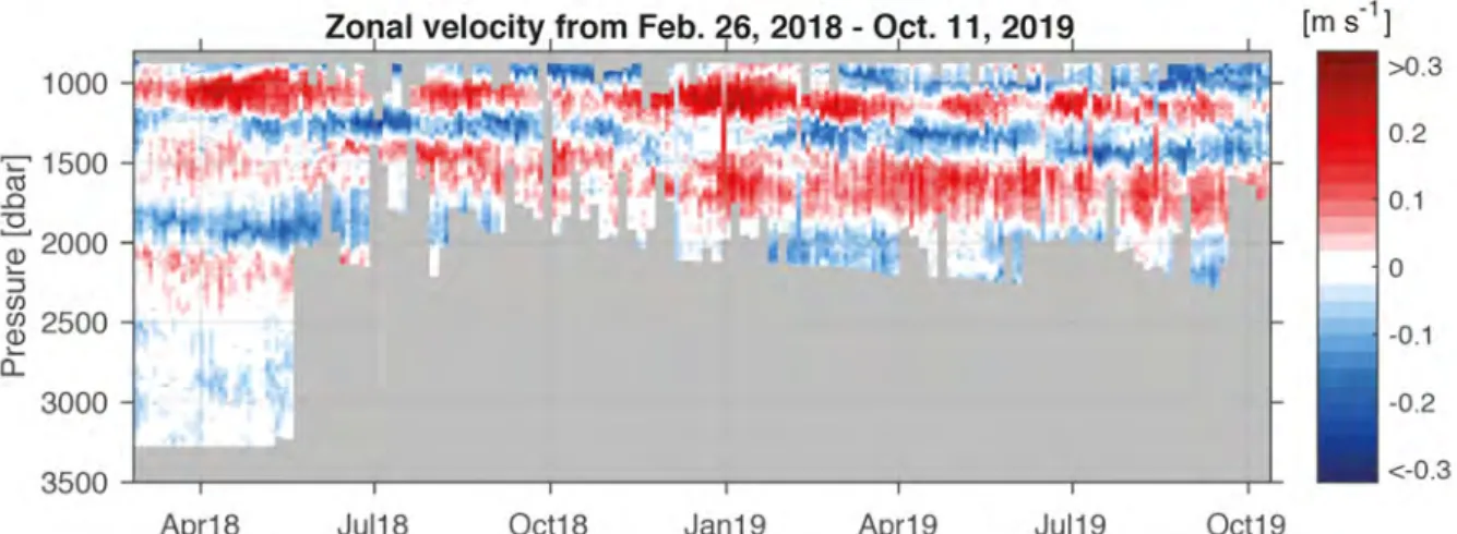
The velocity time series showed very spectacular zonal jets alternating with depths from westward to eastward within a few hundred meters. Several publications showed the importance of this deep equatorial circulation variability for the transport of oxygen and tracers along the equator, but also - due to an associated upward energy propagation - an impact on surface currents, sea surface temperature and climate.
The mooring recovery was very successful and we got back all our instruments installed one and a half year ago during Meteor cruise M145. Here a special thanks to the bosun and his team as well as the bridge for the professional work during mooring recovery.
Instrumentation at the mooring included two acoustic Doppler current profilers covering the depth range from near the surface to about 900 m. Both delivered complete velocity datasets. From 850 and 3300 m water depth a moored profiler should drive up and down the mooring wire. At the beginning of the measuring period, the profiler accurately sampled the whole depth range, while degrading in its measurement range with time only covering the upper part during the later period.
Nevertheless, profiler data nicely show the existence of strong narrow-banded eastward and westward jets (Fig. 1). These data will be used to test and improve ocean models aimed at simulating biogeochemical cycles or predicting tropical climate.
Fig. 1: East (red) - west (blue) velocities measure at the equatorial mooring located at 23°W.
Measurements show strong jets in the depth range from 900 to 2000 m water depth (Franz Philip Tuchen).
Prof. Dr. Peter Brandt Meteor cruise 158
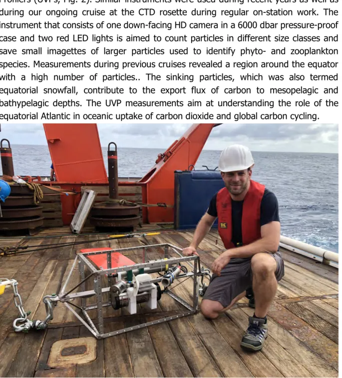
The new deployment of the mooring includes for the first time Underwater Vision Profilers (UVPs, Fig. 2). Similar instruments were used during recent years as well as during our ongoing cruise at the CTD rosette during regular on-station work. The instrument that consists of one down-facing HD camera in a 6000 dbar pressure-proof case and two red LED lights is aimed to count particles in different size classes and save small imagettes of larger particles used to identify phyto- and zooplankton species. Measurements during previous cruises revealed a region around the equator with a high number of particles.. The sinking particles, which was also termed equatorial snowfall, contribute to the export flux of carbon to mesopelagic and bathypelagic depths. The UVP measurements aim at understanding the role of the equatorial Atlantic in oceanic uptake of carbon dioxide and global carbon cycling.
Fig. 2: Underwater Vision Profiler installed in a mooring cage ready for deployment. Rainer Kiko, who established this measurement technique during recent GEOMAR cruises, will join the Laboratoire d’Oceánologie de Villefranche-sur-Mer (LOV), France in December 2019 for five years as part of a recently acquired “Make our Planet Great Again” (MOPGA) project. The UVP deployment is a cooperation between LOV and GEOMAR (Photo Iris Kriest).
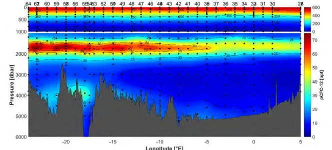
Meanwhile intense on-station work along the equator continues with CTD casts, microstructure measurements and zooplankton net stations. Besides the different instruments installed at the CTD rosette, a large number of water samples are taken to determine different biogeochemical and biological parameters. Among them are transient tracers (CFC-12 and SF6) that are measured with full depth resolution (Fig.
Prof. Dr. Peter Brandt Meteor cruise 158
3). These transient tracers enter the ocean via gas-exchange at the air-sea interface only. The atmospheric concentration history of such tracers provide time information, which can be used to determine the “age” of a water parcel. Age is defined as the time since the last surface contact of a water mass during which it could equilibrate with atmospheric gas concentrations. CFC-12 and SF6 have distinct differences in their atmospheric history, i.e. CFC-12 was released into the atmosphere since the late 1920s whereas SF6 was produced on an industrial scale in the beginning of the 1950s.
Therefore, the CFC-12 tracer can already be found in less ventilated regions where the SF6 tracer is still absent. Age calculations particularly allow estimating the anthropogenic carbon content, which is a key variable to determine the buffer capacity of the world ocean to the increasing CO2 concentrations in the atmosphere. The uptake and storage of dissolved gases in the oceans is one of the most important natural processes, which lower the drastic effects of anthropogenic greenhouse gas emissions.
Fig. 3: Equatorial section of CFC-12 partial pressure showing a tracer maximum between 1300 and 2000 m corresponding to upper North Atlantic Deep Water originating in the Labrador Sea. High CFC concentrations (i.e. relatively young water masses) were also measured in the deep channel of the Romanche Fracture Zone connecting the western and eastern Atlantic basins (Tim Stöven).
At the beginning of the fourth week, we celebrated our half-way party. Having an excellently prepared barbeque on deck of Meteor during the sunset at the equator is surely one of the highlights during the cruise. A special thanks to the cooks and stewards for the preparation and the excellent food.
Greetings from the tropics in the name of the cruise participants of M158, Peter Brandt
GEOMAR Helmholtz Centre for Ocean Research Kiel