EXPEDITION PROGRAMME PS115/1
Polarstern
PS115/1
Tromsø - Longyearbyen
05 August 2018 - 03 September 2018
Coordinator: Rainer Knust Chief Scientist: Volkmar Damm
Alfred-Wegener-Institut Helmholtz-Zentrum
für Polar- und Meeresforschung Am Handelshafen 12
D-27570 Bremerhaven
Telefon: ++49 471 4831- 0 Telefax: ++49 471 4831 – 1149 E-Mail: info@awi.de
Website: http://www.awi.de
Email Coordinator: rainer.knust@awi.de Email Chief Scientist: volkmar.damm@bgr.de
Tromsø – Longyearbyen
05. August 2018 – 03. September 2018
Chief Scientist Volkmar Damm
Coordinator
Rainer Knust
Contents
1. Überblick und Fahrtverlauf 2
Summary and Itinerary 3
2. Structure and Evolution of the NE Greenland Margin 4
2.1 Geophysics 5
2.2. Geological sampling for thermochronological studies 9 2.3. Microbiological and geochemical investigations to understand
gases and microbial processes in Arctic seafloor sediments 10 3. Sediment Coring for Reconstruction of the Environmental and
Climate History off NE Greenland (ECHONEG) 11
4. Bathymetric Mapping and Sub-Bottom Profiling 13 5. At-sea Distribution of Seabirds and Marine Mammals 14 6. The “Year of Polar Prediction” (YOPP): Additional
Radiosoundings during the Special Observing Period 15 7. Beteiligte Institute / Participating Institutes 17
8. Fahrtteilnehmer / Participants 20
9. Schiffsbesatzung / Ship’s Crew 22
1. ÜBERBLICK UND FAHRTVERLAUF
V. Damm (BGR)
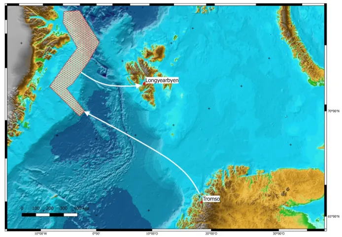
Die Expedition PS115/1 wird am 5. August 2018 mit dem Forschungsschiff Polarstern in Tromsø (Norwegen) beginnen und von der Grönlandsee im Westteil des nördlichen Nordatlantik bis in die Wandelsee führen (Abb. 1). Die Fahrt endet am 3. September in Longyearbyen (Spitzbergen).
Der Schwerpunkt des wissenschaftlichen Forschungsprogramms liegt auf multidisziplinären geowissenschaftlichen Untersuchungen zur Klärung des strukturellen Aufbaus und der tektonischen Entwicklung der Kontinentränder vor Nordost-Grönland. Geologische Beprobungen oberflächennaher Meeresbodensedimente dienen der Rekonstruktion der Sedimentbeckenentwicklung der Schelfgebiete vor Nordost-Grönland. Darüber hinaus bilden Untersuchungen zur Meeresumwelt und Klimaentwicklung einen Teil des Arbeitsprogramms.
Mit diesen Projektarbeiten soll sowohl die derzeit noch lückenhafte Datenbasis zu mikrobiellen Lebensgemeinschaften in arktischen Sedimenten als auch zur Verbreitung von Meeressäugern und arktischen Seevögeln erweitert werden.
Sedimentäre Strukturen entlang von Kontinenträndern bergen Informationen zur Rekonstruktion plattentektonischer Entwicklungen und liefern Rückschlüsse für die Entwicklung von Sedimentbecken einer Region. Bisherige Rekonstruktionen für Nordost- Grönland fordern für das frühe Paläogen annähernd zeitgleich ablaufende Kompressions- als auch Extensionsprozesse für den Bereich Nordostgrönland/Yermak Plateau, die sich unterschiedlich auf die Bildung und Entwicklung von Sedimentbecken auswirken. Neben marinen geophysikalischen Messmethoden (Seismik, Magnetik, Gravimetrie, Wärmestrom- messungen) soll die Erosions- und Hebungsgeschichte der Küstenregion mittels Thermogeochronologie untersucht werden. Die umfassende Analyse dieser strukturbildenden geologischen Prozesse entlang des grönländischen Kontinentrandes hilft auch, bisherige kontrovers diskutierten Annahmen zum Ressourcenpotential der Arktis zu überprüfen, über das derzeit nur sehr unsichere Annahmen vorliegen.
Neben den Rahmenbedingungen der Bildung von Kohlenwasserstoffen im Schelfgebiet vor Nordost-Grönland ist auch Degradation, d.h. der Abbau von Kohlenwasserstoffen durch mikrobielle Lebensgemeinschaften in arktischen Meeresbodensedimenten weitgehend unbekannt und Ziel der Untersuchungen. Die hierfür vorgesehene Beprobung von Meeres- bodensedimente wird im Zusammenwirken mit einem Nebennutzerprojekt vorgenommen, das auf die Rekonstruktion der Glazial- und Klimageschichte anhand der in den Sedimenten enthaltenen Proxy abzielt.
Alle Forschungsaktivitäten werden unter Berücksichtigung hoher Umweltstandards zum Schutz mariner Säuger durchgeführt. Neben externen Walbeobachtern werden unterschiedliche akustische Überwachungssysteme und das Infrarotdetektionssystem AIMMMS zur Überwachung der Meeresumwelt speziell während der seismischen Messungen eingesetzt. Diese Vorsorgemaßnahmen werden ergänzt und begleitet durch eine Projektgruppe, die mit einer eigenständigen Langzeitstudie die Verteilung von Meeresvögeln und marinen Säugern über den gesamten Fahrtverlauf dokumentiert.
Abb. 1: Geplanter Fahrtverlauf der Polarstern-Expedition PS115/1 Fig. 1: Planned route of the Polarstern expediton PS115/1
SUMMARY AND ITINERARY
Cruise PS115/1 of the research vessel Polarstern will start in Tromsø August 5, 2018 and will track from the Greenland Sea in the western part of the northernmost North Atlantic to the Wandel Sea (Fig. 1 and conclude in Longyearbyen, Spitsbergen, on September 3, 2018.
The scientific research programme focuses on multidisciplinary geoscientific investigations to clarify the structural composition and tectonic development of the continental margin off northeast Greenland. Geological sampling of near-surface seabed sediments aim to reconstruct the sediment basin development of the shelf areas off NE Greenland.
Additionally, studies on the marine environment and climate development form part of the work programme. The aim of this project is to expand the currently incomplete data base on microbial communities in Arctic sediments, as well as the distribution of marine mammals and Arctic seabirds.
Sedimentary structures along continental margins hold information on the evolution of plate tectonics in the region and help develop scenarios of sedimentary basin evolution. Previous NE Greenland reconstructions call for near-simultaneous compression and extension
processes in the Northeast Greenland / Yermak Plateau area for the early Paleogene, affecting both the formation and development of sedimentary basins. In addition to marine geophysical measurement methods (seismics, magnetics, gravimetry, heat flow measurements), the erosion and uplift history of the coastal region will be investigated by means of thermo-geochronology. The comprehensive analysis of these structure-forming geological processes along the Greenland continental margin will also help to review previously controversial assumptions about the resource potential of the Arctic, about which only very uncertain assumptions are currently available.
In addition to the framework conditions for the formation of hydrocarbons in the shelf area off NE Greenland, the degradation of hydrocarbons by microbial communities in arctic seabed sediments is largely unknown and are a focus of the scientific investigations. The sampling of seabed sediment intended for this purpose will be carried out in conjunction with a secondary user project aimed at reconstructing the glacial and climatic history using the proxy contained in the sediments.
All research activities will be conducted in accordance with high environmental standards for the protection of marine mammals. In addition to external whale watchers, different acoustic monitoring systems and the AIMMMS infrared detection system will be used to monitor the marine environment, especially during seismic measurements. These precautionary measures will be supplemented and accompanied by a project group, which documents the distribution of seabirds and marine mammals over the entire course of the journey as part of a separate long-term study.
2. STRUCTURE AND EVOLUTION OF THE NE GREENLAND MARGIN
A. Ehrhardt, I. Heyde, M. Krüger, V. Damm, (BGR),
W. Geissler (AWI), C. Spiegel (University of Bremen – not on board)
The plate tectonic history of Greenland is very complex, especially in the transition from Paloecene to Eocene, when Greenland acted as independent plate (Tessensohn and Piepjohn, 2000). In this time period Greenland compensated the seafloor-spreading in Labrador Sea and Baffin Bay until chron C24 and starting from chron C24 seafloor-spreading in the North-Atlantic (Jackson and Gunnarson, 1990, Tessensohn and Piepjohn, 2000) most likely by an anti-clockwise rotation that caused a northward movement of Greenland with respect to Eurasia in the Palaeogene about 50 Mio years ago. A northward motion of Greenland resulted in compression affecting the region of northern Greenland and Svalbard.
At the same time seafloor spreading in the Eurasia basin initiated extension separating the Yermak Plateau and Moris Jesup Rise.
Fig. 2.1: Proposed survey lines and sampling stations during PS115/1
The question arises how far did the compression extend to the north originated by the northward movement of Greenland and did this process result in an overriding of the early oceanic crust in the Eurasian basin by the North Greenland continental margin.
We aim to characterize the style of deformation which affected the NE Greenland margin and to quantify compression versus extension that is manifested in sedimentary basins in the region. This provides the basic facts to conclude whether Greenland act as an independent plate with predominantly N-S compression in the north during the Paleogene, or was it attached to North America and underwent an anti-clockwise rotation resulting in oblique compression with strike-slip in the north.
2.1 Geophysics
A. Ehrhardt, I. Heyde, H.-O Bargeloh, Th. Behrens, K. Berglar, J. Deppe, T. Ebert, D.
Franke, B. Hahn, St. Ladage, R. Lutz, M. Schauer, P. Steinborn (BGR), W. Geissler, A.
Brotzer, M. Hiller, M. Lösing (AWI), Th. Funck (GEUS) Objectives
In the course of the project Greenmate we want to acquire a new set of geophysical data that will contribute to the plate tectonic reconstruction of the NE-Greenland margin (Fig. 2).
• Multichannel seismic data will image the deformation of the sediments and the crystalline basement. The deformation gives evidence for the chronological and spatial displacement pattern along the NE-Greenland margin.
• A refraction / wide angle seismic line will image the deeper crust and the crust mantle transition. The knowledge of the deeper crust and its seismic sound
velocities will contribute to identify the actual Continent Ocean Boundary (COB) and the type of continental margin.
• Magnetic data acquisition along the planned profiles lines will help to identify the oldest magnetic seafloor spreading anomalies which mark the onset of the spreading between Yermak Plateau and Morris Jesup Plateau. This would give direct evidence of the continent ocean boundary and the age of the North Atlantic oceanic crust. Ideally, also the direction of the opening of the North Atlantic could be determined.
• Gravity data will be used for quantitative statements of crustal thickness and lateral discrimination of crustal blocks. In particular, the interpretation will include forward modelling of gravity anomalies along a number of key profiles to develop sound density models.
• Heat flow density data acquired at the proposed sediment sampling and OBS recovery stations will be used to estimate paleo-temperatures and geothermal gradients which affect the maturation of organic sequences. Basin modelling is based on sediment thicknesses and paleo-temperatures for assessment of the hydrocarbon potential of sedimentary basins. As an additional tool, heat flow measurements might assist in restraining age estimates of the oceanic crust.
Work at sea
Multichannel seismic data acquisition (MCS) and refraction seismic data acquisition is planned in order to image the NE-Greenland continental margin and to identify the nature of the margin (i.e. sheared margin with compression or extension). For the MCS data acquisition two setups will be prepared.
(I) for open waters with less than approx. 20 % ice coverage a 3,000 m solid state seismic cable (i.e. no oil within the seismic cable) will be deployed (hydrophone group distance 12.5 m i.e. total number of groups/channels 240).
(II) In case of dense ice coverage of 30 % and more a short solid state cable with 150 m to 600 m will be deployed with group distance of 6.25 m and total number of channels of 24 to 96.
One refraction / wide angle seismic line is planned in the southern part of the survey area crossing the NE-Greenland continental margin in order to image the deeper crust and mantle and the Continent-Ocean Boundary (COB). Up to 21 ocean bottom seismometers (OBS) will be deployed with a distance between OBS of max 10 km. However, the application of the OBS is depending on the prevailing sea ice situation. In the case of inadequate ice situation sonobuoys could be applied for the refraction seismic data acquisition. However, in case of sonobuoy application the maximum offset of refraction/wide angle data recording is limited by the range of the UKW radio data transfer (approx. 30 km). In addition, sonobuoys will be deployed in order to complement MCS data acquisition when only short cable deployment is possible, in order to record long offset data at key positions for a solid control on the seismic velocities.
As seismic source an array of 8 x 250 in³ G-Guns will be used and operated with 150 bar.
The array is assembled in a compact manner and will be towed close behind the stern of the vessel in order to protect the array from collisions with sea ice.
In order to minimize the impact of the seismic source to the marine environment all seismic operations will be carried out in close communication and surveillance of marine mammal observers (MMO). The MMO are in charge to implement the guidelines of the Greenland authorities (Offshore Seismic Surveys in Greenland, Guidelines to best environmental practices, environmental impact assessments and environmental mitigation assessments –
2015). They are authorized to stop and recommence seismic operations according to the above guidelines. The MMOs on duty will liaise with the seismic crew by direct communication channels to ensure that all actions and procedures of the above guidelines will be followed during seismic operations. The detection of marine mammals in the vicinity of the vessel will be ensured by continuous visual observation (because of 24h daylight) and supported by an infrared detection system (Zitterbart et al., 2013) and by passive acoustic monitoring systems (PAM):
• conventional PAM system, a 250 m towed cable with 4 broadband hydrophones as a stand-alone system
• Sercel QuitSeaTM system, a new Sercel product, fully integrated in the seismic streamer and Sercel data acquisition operating automatically.
For magnetic data acquisition three different magnetic instruments will be used:
(a) A towed marine gradient magnetometer consisting of two Overhauser sensors (SeaSPY system). The gradient configuration allows the distinction between magnetic anomalies and magnetic variations. This is important, because strong magnetic disturbances must be expected in the survey area situated in high magnetic latitudes.
(b) A vector magnetometer integrated in the towed gradient magnetometer system. Under favourite conditions, vector measurements on single lines give information about the strike of magnetic anomalies in the absence of parallel profiles. This is important because of the lack of regular parallel lines planed for the survey.
(c) The shipboard vector magnetometer installed permanently on Polarstern. This system will be helpful on any kind of lines where the towed gradient and vector magnetometers cannot be deployed due to the ice conditions, as they are very sensitive to ice coverage.
It is intended to deploy the towed instruments on all seismic and longer transit lines.
Processing and evaluation of the profiles will partly be done on the vessel. Magnetic data from a magnetic reference station set up by BGR during the CASE20 expedition near Station Nord and Svalbard and Greenland magnetic observatory data will be used after the cruise to perform additional corrections for magnetic variations.
Gravity data acquisition is conducted by the KSS32M seagravimeter, which is permanently installed onboard Polarstern, will be used for the gravity measurements. Tie measurements to onshore reference stations with known absolute gravity values will be carried out with an appropriate land gravimeter in Tromsø and Longyearbyen. Shipboard gravity measurements will be conducted during the entire cruise on all profile and transit lines. The measured free- air gravity anomalies will be compared with other data sets especially those derived from satellite altimetry. Our experience on numerous cruises showed that gravity anomalies derived from satellite altimetry are of great importance to get an overview of the gravity field in an oceanic area. For detailed investigations, however, shipboard gravity measurements are more accurate and thus indispensable.
Heat flow density measurements are planned to be conducted in areas where seismic lines give us information on the sediment thickness and a rough estimate on sedimentation rates.
In this way the true heat flow value, corrected for sedimentation effects, can be determined.
We plan to restrict the heat flow measurements to areas with water depths in excess of
»1,200 m to exclude the effect of seasonal temperature variations. The points of measurement should be dispersed throughout the area of investigation in the hope to determine a systematic heat flow pattern. The total number of stations for heat flow measurements is planned to be limited to 30. Since we expect relatively hard ground conditions (dropstones, relatively coarse, ice-rafted debris), we plan to operate exclusively the hard-ground heat flow probe of BGR.
Expected results
The planned seismic lines cross the presumed sheared continental margin of NE-Greenland.
The setup of seismic source and receivers in combination with the refraction/wide angle seismic line will allow to image sedimentary cover down to the crystalline basement. It is of special interest to image the deformation pattern of the basement and the sedimentary cover in order to reconstruct the relative plate motion of the Greenland plate and the Eurasian plate.
Magnetic data should allow to determine the continent-ocean boundary, the age of the oceanic crust and the opening direction. These parameters would have a fundamental impact on plate tectonic models for the history of the surrounding continents and oceans.
Additionally, magnetic data are also required to support an integrated interpretation of continental margin structures. Other results will be structural information on the location of fault systems, the presence of volcanic intrusions, magmatic bodies and different types of continental basement in conjunction with seismic and gravity data.
Detailed free-air gravity and Bouguer anomaly maps of the survey area will be produced. The further interpretation will include forward modelling of anomalies along a number of key profiles to develop sound density models. The corresponding results of the reflection seismic interpretation and refraction seismic data will be taken into account and integrated. The models will provide constraints on sediment thicknesses and basement structures. It should be possible to indicate the transition from continental to oceanic crust due to their different thicknesses. This parameter would have impact on plate tectonic models for the survey region.
Oceanic crust underlying the western Fram Strait should be fairly young, as the opening occurs only since the Eocene/Oligocene. Therefore, we expect high heat flow values. In combination with the results of the seismic measurements we expect to resolve the influence of high sedimentation rates on the heat flow.
Data management
The data will be stored in the BGR data storage IT center. It is a certified IT-center with redundant servers and copies in spatial separated facilities.
During the first temporarily restricted access to the unpublished scientific data, metadata already can be retrieved. The data management infrastructure ensures the identification of responsible persons according to the metadata. This ensures the identification and location of information to allow access to unpublished data without challenging data security.
Afterwards the data can be accessed after the terms and conditions of BGR.
References
Jackson HR, Gunnarsson K (1990) Reconstructions of the Arctic: Mesozoic to Present.
Tectonophysics, 172, 303-322.
Tessensohn F, Piepjohn K (2000) Eocene Compressive Deformation in Arctic Canada, North Greenland and Svalbard and Its Plate Tectonic Causes. Polarforschung,68, 121-124.
Zitterbart D, Kindermann L, Burkhardt E, Boebel O (2013) Automatic Round- the-Clock Detection of Whales for Mitigation from Underwater Noise Impacts. PLOS One, https://doi.org/10.1371/journal.pone.0071217.
2.2. Geological Sampling for Thermochronological Studies
M. Zundel (University of Bremen), K. Meier (University of Bremen), C. Spiegel (not on board) Objectives
The objective of this part of the expedition is to obtain samples for petrographic and thermochronological analysis (mostly apatite fission track and (U-Th)/He analysis). These methods allow tracing geodynamic processes within the upper ~5 km of the earth´s crust.
Furthermore, thermochronological age patterns contained in clastic sediments are indicative for certain source areas. Samples collected during PS115/1 will be used to address the following questions / topics:
(i) Erosion and exhumation history of the Northeast Greenland continental margin in response to Eocene collision of Greenland with the Barents Sea margin, and in response to subsequent extensional processes leading to the opening of the Fram Strait;
(ii) Movement history of the onshore Trolle Land Fault System and its potential offshore continuation, the Greenland Fracture Zone. These fault zones have played a major role for both, Cenozoic compression and extension;
(iii) Provenance of the clastic infill of Wandel Sea and Danmarkshavn Basins. This question is important for deciphering erosion patterns of the source area at the time of deposition, but also gives evidence on reservoir characteristics of the basin deposits, and
(iv) Post-depositional thermal histories of the Wandel Sea and Danmarkshaven Basins. This question is relevant for understanding the regional tectonic history, but also for assessing the potential formation of hydrocarbon resources.
Work at sea and on land
At sea, we will work together with the other marine geology groups, aiming at coring sediments from different parts of the Danmarkshavn Basin, Tethys Basin, Danmarkshavn Ridge, Koldewey Platform, and the offshore portions of the Wandel Sea Basin. We are particularly interested in obtaining coarse-grained (sandy fraction, pebbles) sediments from the Cretaceous to Paleogene deposits which may crop out directly at the seabed, as suggested by seismic data (Hamann et al., 2005). Furthermore, we aim to dredge in-situ rocks from the (presumably) continental East Greenland Ridge, adjacent to the Greenland Fracture Zone. In case of favorable ice conditions, we also plan to dredge rocks from the Morris Jesup Rise (and / or northern Yermak Plateau), for obtaining information on crustal nature and age of the plateau(s). For complementing offshore sample collection, we will use the board helicopters of Polarstern for collecting onshore samples from the Northeast Greenland margin. Here, we are particularly interested in obtaining rocks from the transition between the Paleozoic Caledonian orogen and the Cenozoic Wandel Hav Mobile Belt in the south, from the Wandel Hav Mobile Belt itself, and from the Cenozoic-deformed rocks of Northern Greenland, north of the Wandel Hav Mobile Belt.
Expected results
The main result will be having obtained a set of samples suitable for thermochronological, geochronological, and petrographic analysis, which allows for reconstructing the Cenozoic tectonothermal history of Northeast Greenland. From helicopter-supported onshore fieldwork, we also expect to obtain structural data, which will complement the interpretation of the thermochronology data.
Data management
After publications in peer-reviewed journals, all data will be made publicly available by submitting to the open-access library PANGAEA.
References
Hamann N, Whittaker R, Stemmerik L (2005) Geological development of the northeast Greenland shelf, in Petroleum Geology: North-West Europe and Global Perspectives: Proceedings of the 6th Petroleum Geology Conference, Geol. Soc., London, 887-902.
2.3. Microbiological and geochemical investigations to understand gases and microbial processes in Arctic seafloor sediments
M. Krüger, I. Kruckemeyer, A. Lückge, Ch. Seeger (BGR), F. Musat (UFZ), M. Ruben (Uni Bremen). Not on board: S. Kasten (AWI), H.-H. Richnow, L. Adrian (UFZ), M. Blumenberg, P. Weniger (BGR)
Objectives
Both the structural and the tectonic evolution of the Wandel Sea Basin and adjacent areas are poorly explored and remain a matter of ongoing debate. Geophysical testing of the contrasting tectonic models is expected to shed light on the geometric and thermal evolution of this basin. Since basin evolution has a major effect on petroleum generation and migration, we intend to study the quantity, the chemical and the isotopic compositions of gases adsorbed by surface sediments in the study area. These compositional data shall be interpreted in the context of the measured basin geometry and heat flow to be integrated into a model of hydrocarbon generation and migration.
Besides its structure and tectonic evolution, also the geological and biogeochemical characteristics of the NE Greenland and the adjacent continental shelf and margin areas are largely unknown. Our aim is to study the geochemistry and geomicrobiology in Arctic sediments, and to quantify and identify the prokaryotes, which drive major elemental cycles of e. g. N, C, S in respective ecosystems. Another objective is the oil biodegradation potential of the indigenous microbiota for a potential oil spill under polar in-situ conditions. A third objective will be the microbial degradation and production of the greenhouse gas methane by sedimentary microbial communities. Sediments, water and ice samples will be collected (1) using coring instruments at the seafloor, and
(2) directly at the coastline using small push cores.
These samples will then be sealed (partly frozen) and transported to the BGRs laboratories for geochemical, micro- and molecular biological analyses.
Work at sea
Along several transects sediment echosounder surveys will be conducted parallel to seismic surveys to determine those sites on the profiles, which show a maximum sediment thickness enabling sufficient core material retrieval. At sites selected in collaboration with other working groups long and short sediment cores will be obtained. Short cores (multicores and/or at selected sites also giant box cores, 30-80 cm long) will be used to ensure the availability of sediments from the sediment-water interface. Longer gravity cores (up to 5 m) will be employed to collect deep (gas) geochemical and microbiological profiles.
Retrieval, handling and sampling of obtained sediment cores will be performed at sea in collaboration with other working groups. Cores will be described and photographed on board.
Measurements on unopened cores and continuous sampling of opened cores (subcores and/or work halves) will be performed at sea in various ways and for various purposes.
Sediment and porewater samples for geochemical analyses will be taken in short intervals along the cores onboard. These will then be prepared and fixed for the later determination of total organic carbon, elemental (especially Fe-, Mn-species) composition, stable C and H- isotopes, microbial substrates, sulfate/sulfide concentration, and profiles of methane and
CO2. Representative samples will be frozen immediately for later laboratory analysis of adsorbed hydrocarbons (methane and higher hydrocarbons).
Microbiological samples for the determination of microbial activities and communities will be collected from the same sediment depths as the geochemistry samples. Sediment microcosms will be set-up onboard to measure on site rates of important microbial processes, i.e. sulfate reduction, methane and carbon dioxide formation and consumption, as well as the degradation of different higher hydrocarbons. This will be done using gas chromatography and photometric analyses.
Samples for molecular biological studies of the quantitative and qualitative microbial community composition will be collected, partially fixed for FISH (Fluorescence in-situ hybridization) and stored frozen until further onshore analyses.
Expected results
The marine geochemical and microbiological work during expedition PS115/1 will broaden the basis of available knowledge on Arctic sediments by adding data from a number of new transects across the NE Greenland shelf and continental margin. New sediment cores from suitable sites will be obtained and analysed using a diverse and comprehensive set of inorganic and organic geochemical as well as micro- and molecular biological techniques.
Results of these onboard and laboratory investigations will improve our understanding of the geochemistry and geomicrobiology in Arctic sediments, and help to quantify and identify the prokaryotes, which drive major elemental cycles in this sensitive and unique geosystem.
Data management
All data obtained from geochemical and microbiological analyses of sediment cores at sea and in the home laboratories will be stored in BGR/AWI/UFZ data repositories and will be published in scientific journals.
3. SEDIMENT CORING FOR RECONSTRUCTION OF THE ENVIRONMENTAL AND CLIMATE HISTORY OFF NE GREENLAND (ECHONEG)
R. Spielhagen (GEOMAR), I. Olsen (UiT), N. Syring (AWI), M. Zehnich (GEOMAR), M. Forwick (UiT, not on board), R. Stein (AWI, not on board)
Objectives
Currently our knowledge of the glacial, deglacial and Holocene history of NE Greenland and the adjacent continental shelf and margin areas is rather limited. In particular, this accounts for the continental ice extent, sea-level rise, water mass distributions, ice coverage and freshwater export from the Arctic Ocean. During expedition PS115/1 it is intended to strongly improve this knowledge through the establishment of paleoclimate proxy records on sediment cores from selected sites in the work area. Proxies to be used include grain sizes, microfossil associations, the geochemical and isotopic composition of calcareous microfossils, organic sediment components (e.g., biomarkers), ice-rafted detritus, X-ray fluorescence variability, and others. These records will complement the currently available basis for a synoptic analysis of the natural variability of the Arctic atmosphere-ice-ocean system, including leads and lags of individual parameters in this system, and for a realistic modelling effort that couples the North Atlantic and Arctic oceans. The work programme of the ECHONEG group during expedition PS115/1 has three major goals which can be achieved by obtaining long and short sediment cores.
Goal I is to extend the available core data base from the NE Greenland continental margin and shelf to the area north of 81°N and to nearshore areas not sampled during expedition PS93.1 in 2015 (which concentrated on the continental margin, except at 80.5°N). By investigating these cores the ECHONEG group wants to distinguish IRD from different sources in NE Greenland and reconstruct the glacial history of the hinterland in a more comprehensive way than what is possible with the PS93.1 cores alone. The reconstruction will be done by comparing IRD in time-equivalent layers in cores from PS115/1 and from PS93.1.
Goal II is to obtain large-volume (Kastenlot) cores from suitable sites on the shelf, in particular small morphological basins south of 80.5°N. Here, the Holocene history of Atlantic Water advection on the outer NE Greenland shelf and continental margin is recorded in multidecadal resolution.
Goal III is to obtain additional sediment cores from small morphological basins and from moraine ridges on the outer and middle shelf to reconstruct and date glacial events and the onset of marine conditions on the shelf immediately postdating the deglaciation. According to the very few dates from oldest Holocene marine organisms available so far, the initial deglaciation occurred during the time of maximum advection of relatively warm Atlantic Water to the Fram Strait (~10.8-8.5 ka). It is intended to explore this relationship in more detail by dating the interface between glacial tills and oldest deglacial marine deposits in sediment cores from various places on the NE Greenland shelf.
Work at sea
To identify suitable sites, the PARASOUND system of Polarstern is essential for all working groups interested in obtaining sediment cores. Along several transects PARASOUND sediment echosounder surveys will be conducted parallel to seismic surveys. The PARASOUND system usually has a penetration of 20-70 m in hemipelagic Arctic sediments.
This is sufficient for tracing key reflectors and determining those water depths and sites on the profile which show a maximum thickness of the uppermost layers (supposed to be of Late Quaternary age).
At sites selected in collaboration with other working groups long and short sediment cores will be obtained. Short cores (giant box cores and/or multicores, 30-50 cm long) ensure the availability of sediments from the sediment-water interface which ideally reflect the modern environment at the site. Depending on sedimentation rates, the undisturbed sedimentary sequences in short cores cover the last few kiloyears (or ideally less) of environmental history. To obtain long sedimentary records, square-barrel gravity corers ("kastenlot corers", 30x30 cm, up to 17 m long) and/or conventional gravity corers (12 cm in diameter, up to 15 m long) will be used.
Retrieval, handling and sampling of obtained sediment cores will be performed at sea in collaboration with other working groups. Cores will be described and photographed on board.
Measurements on unopened cores and continuous sampling of opened cores (subcores and/or work halves) will be performed at sea in various ways and for various purposes, including several large-volume archive boxes (parallel sampling). Subcores (archive halves) will be stored cool or frozen and transported to the AWI core repository. Time permitting, preliminary analyses of the sediment composition (ice-rafted debris, microfossils) will be performed on board. Further analyses on samples obtained for the ECHONEG group will be performed in the home laboratories in Bremerhaven, Kiel, and Tromsø. This work will comprise a huge set of analyses and proxy investigations like, e.g., XRF-scanning, grain sizes, biomarkers, stable carbon and oxygen isotopes of foraminifers, microfossil associations, Mg/Ca ratios of carbonate microfossils, clay and bulk mineralogy, etc.
Expected results
Marine geological work during expedition PS115/1 will broaden the basis of available (sub)sea-floor data by adding PARASOUND data from a number of new transects across the NE Greenland shelf and continental margin. New sediment cores from suitable sites will be obtained and made available to interested scientists beyond the group of researchers from the shipboard scientific party. Results of paleoceanographic investigations by the ECHONEG group will improve our understanding of past environmental changes in the Arctic and provide insight into processes governing ongoing climate changes in this sensitive area.
Data management
All data obtained from sediment core analyses at sea and in the home laboratories will be stored at the PANGAEA data repository and will be made public at PANGAEA after publication. Metadata will be freely available at PANGAEA.
4. BATHYMETRIC MAPPING AND SUB-BOTTOM PROFILING
A. Jegen, N-M. Lešić, M. Lütjens (AWI), B. Dorschel, S. Dreutter (AWI, not on board) Objectives
Accurate knowledge of the seafloor topography, hence high-resolution bathymetry data, is key basic information necessary to understand many marine processes. It is of particular importance for the interpretation of scientific data in a spatial context. Bathymetry, hence geomorphology, is furthermore a basic parameter for the understanding of the general geological setting of an area and geological processes such as erosion, sediment transport and deposition. Even information on tectonic processes can be inferred from bathymetry.
Supplementing the bathymetric data, high-resolution sub-bottom profiler data of the top 10s of meters below the seabed provide information on the sediments at the seafloor and on the lateral extension of sediment successions. In this way, the sub-bottom data supplements the 3rd dimension to the bathymetric maps.
Although intensively investigated, areas without high-resolution swath bathymetry coverage still exist in the research area. For those areas, the bathymetry is modelled from satellite altimetry with according low resolution. Satellite altimetry derived bathymetry lack the resolution necessary to resolve small- to meso-scale geo-morphological features (e.g.
iceberg ploughmarks, sediment waves, and erosional escarpments). Ship-borne multibeam data provide bathymetry information in a resolution sufficient to resolve those features.
Hydroacoustic data furthermore provide valuable information for site selection for the other scientific working groups on board.
Work at sea
Bathymetric data will be recorded with the hull-mounted multibeam echosounder Atlas Hydrosweep DS3, and sub-bottom data will be recorded with the hull-mounted sediment echosounder Atlas Parasound P70. The main task of the bathymetry group is to plan and run bathymetric surveys in the survey areas and during transit. The raw bathymetric data will be corrected for sound velocity changes in the water column and will be further processed and cleaned for erroneous soundings and artefacts. Detailed seabed maps derived from the data will provide information on the general and local topographic setting in the study areas. High- resolution seabed and sub-bottom data recorded during the survey will be made available for site selection and cruise planning. During the survey, the acoustic measurement will be carried out by three operators in a 24/7 shift mode.
Expected results
Expected results will consist of high-resolution seabed maps and sub-bottom information along the cruise track and from the target research sites. The bathymetric and sediment acoustic data will be analyzed to provide geomorphological information of the research area.
Expected outcomes aim towards a better understanding of the geological and, particularly, the sedimentary processes in the research area.
Data management
Bathymetric data collected during the expedition will be stored in the PANGAEA data repository at the AWI. Furthermore, the data will be provided to mapping projects and included in regional data compilations such as IBCAO (International Bathymetric Chart of the Arctic Ocean) and GEBCO (General Bathymetric Chart of the Ocean). Bathymetric data will also be provided to the Nippon Foundation – GEBCO Seabed 2030 Project.
5. AT-SEA DISTRIBUTION OF SEABIRDS AND MARINE MAMMALS
H. Robert (RBINS/PoIE), T. Schwenke, M. Watelet (PolE), C.R. Joiris (PoIE, not on board) Objectives
This expedition is part of our long-term study on the quantitative at-sea distribution of the marine “upper trophic levels” - seabirds and marine mammals - in polar ecosystems, aiming at quantifying the factors influencing their distribution as well as detecting possible spatial and temporal changes, with special attention to hydrography and to global climate changes.
Main hydrological factors are (upwelling) fronts between water masses, as well as ice edge, and sometimes icebergs, in both polar areas. Such fronts, detected by changes in water temperature (SST) and salinity, are often bound to the continental slope, and are thus indirectly reflected by changes in bathymetry. Such areas can attract very high concentrations of “top predators”: seabirds, seals and/ or whales, e.g. fin or humpback whales, harp seals, etc. (Joiris & Falck, 2010; Joiris et al., 2010; Joiris, 2011; Joiris et al., 2014), obviously reflecting huge concentrations of prey – zooplankton and small fish (remark:
such hotspots should also deserve special attention by zooplankton and fish specialists!).
The importance of seabird and marine mammal hotspots in both Arctic and Antarctic, mainly in autumn, was stressed (Joiris, 2018).
Temporal changes were detected already by this team, mainly based on many polar expeditions on board Polarstern between 1988 and 2014 in the Greenland Sea, Fram Strait and Arctic Ocean, e.g. the decrease of ivory and Ross’s gulls (Joiris, 2016) or the influx of large whales in the same area (Joiris, 2016a), especially bowheads, probably entering from the Pacific stock as a consequence of decreasing ice coverage and opening the North-East and/ or North-West Passages from 2005-2007 on. Moreover, a recently discovered ivory gull colony on an iceberg off North-East Greenland (Nachtsheim et al., 2015) would deserve a new visit if possible.
Work at sea
Seabird and marine mammal quantitative distribution at sea will be established during 30 min transect counts from the bridge on a continuous basis by moving ship by one observer, light and visibility conditions allowing, without width limitation.
The PoIE-team will actively participate in the mitigation measures for marine mammals during the seismic operations (ship too slow for “normal” counting periods).
Expected results
The main analysis of data will concern on the one hand the importance of hydrography on their distribution: water masses and fronts, pack ice and ice edge, and icebergs. On the other hand to try and detect temporal and geographical changes, in comparison with the numerous data collected by this team on board Polarstern.
Data management
Data will first be available in our PolE dataset (crjoiris@gmail.com), and later integrated in an international dataset biodiversity.aq.
References
Joiris CR and Falck E (2010) Summer at-sea distribution of little auks Alle alle and harp seals Pagophilus (Phoca) groenlandica in the Fram Strait and the Greenland Sea: impact of small-scale hydrological events. Polar Biology, 34, 541-548 (2011). DOI: 10.1007/s00300-010-0910-0.
Joiris CR (2011) A major feeding ground for cetaceans and seabirds in the south-western Greenland Sea. Polar Biology, 34, 1597-1607. DOI: 10.1007/s00300-011-1022-1.
Joiris CR, Falck E, D’Hert D, Jungblut S, and Boos K (2014) An important late summer aggregation of fin whales Balaenoptera physalus, little auks Alle alle and Brünnich’s guillemots Uria lomvia in the eastern Greenland Sea and Fram Strait: influence of hydrographic structures. Polar Biology, 37, 1645-1657. DOI: 10.1007/s00300-014-1551-5.
Joiris CR (2016) Drastic decrease of high Arctic gulls – ivory Pagophila eburnea and Ross’s Rhodostethia rosea – in the northern Greenland Sea and Fram Strait from 1988 to 2014. Polar Biology, 40, 1029-1034. DOI: 10.1007/s00300-016-2027-6.
Joiris CR (2016a) Considerable increase in bowhead, blue, humpback and fin whales numbers in the Greenland Sea and Fram Strait between 1979 and 2014. Advances in Polar Science, 27, 117-125.
DOI: 10.13679/j.advps.2016.2.00117.
Joiris CR (2018) Seabird and marine mammal “hotspots” in polar seas. Lambert Academic Publishing, Düsseldorf, Germany. 48 pp. ISBN : 978-620-2-19805-9.
Nachtsheim DA, Joiris CR and D’Hert D (2015) A gravel-covered iceberg provides an offshore breeding site for ivory gulls Pagophila eburnea off Northeast Greenland. Polar Biology, 39, 755- 758. DOI: 10.1007/s00300-015-1824-7.
6. THE “YEAR OF POLAR PREDICTION” (YOPP):
ADDITIONAL RADIOSOUNDINGS DURING THE SPECIAL OBSERVING PERIOD
H. Meyer (Uni Bremen)., Holger Schmithüsen (AWI, not on board) Objectives
The „Year of Polar Prediction“ (YOPP) is one of the key elements of the Polar Prediction Project (PPP, www.polarprediction.net). Its mission is:
Enable a significant improvement in environmental prediction capabilities for the polar regions and beyond, by coordinating a period of intensive observing, modelling, verification, user-engagement and education activities.
Within YOPP there are three “Special Observing Periods” (SOPs) defined:
SOP-NH1: 1 Feb. 2018 – 31 Mar. 2018 in the Arctic SOP-NH2: 1 Jul. 2018 – 30 Sep. 2018 in the Arctic SOP-SH: 16 Nov 2018 – 15 Feb 2019 in the Antarctic
To contribute to the special observing efforts of YOPP the radiosounding activity on board Polarstern is increased to 4 soundings per day. This follows the internationally compiled science plan of PPP1 and the recommendations in the implementation plan2 of the project.
Work at sea
Whenever Polarstern is north of 60°N, the routinely launched daily radiosounding is extended by another 3 soundings per day. Together, the soundings cover all synoptic main hours, namely 00, 06, 12 and 18 UTC.
Data management
Data management is identical to the routinely performed radiosoundings. Data on board will be made available through the DWD staff to any interested scientist. Data will be published on Pangaea after the cruise. Any scientific publication shall use the data from Pangaea.
Expected results
Radiosonde measurements are known to be one of the highest impact global observation systems for operational weather prediction analysis (“analysis” is the best guess of the status of the atmosphere at a certain point in time). Temporarily intensified soundings, together with modelling studies, are capable to quantify the impact on operational analysis products.
During YOPP it is expected that the impact of polar radiosounding activities on weather prediction capabilities can be estimated. This will give important reasoning for the optimisation of the polar meteorological observation network, which is one distinct goal of YOPP.
References
1 World Weather Research Programme (2013) WWRP Polar Prediction Project Science Plan.
WWRP/PPP No. 1. World Meteorological Organization, Geneva.
http://www.polarprediction.net/fileadmin/user_upload/www.polarprediction.net/Home/Documents/Fi nal_WWRP_PPP_Science_Plan.pdf
2 World Weather Research Programme (2016) WWRP Polar Prediction Project Implementation Plan for the Year of Polar Prediction (YOPP), Version 2.0. WWRP/PPP No. 4. World Meteorological Organization, Geneva.
http://www.polarprediction.net/fileadmin/user_upload/www.polarprediction.net/Home/YOPP/YOPP_
Documents/FINAL_WWRP_PPP_YOPP_Plan_28_July_2016_web-1.pdf
7. BETEILIGTE INSTITUTE / PARTICIPATING INSTITUTES
Address
AWI Alfred-Wegener-Institut
Helmholtz-Zentrum für Polar- und Meeresforschung
Am Handelshafen 12 27570 Bremerhaven Germany
BGR Bundesanstalt für Geowissenschaften
und Rohstoffe Stilleweg 2 30655 Hannover Germany
DWD Deutscher Wetterdienst
Geschäftsbereich Wettervorhersage Seeschifffahrtsberatung
Bernhard-Nocht Strasse 76 20359 Hamburg
Germany
GEOMAR Helmholtz-Zentrum für Ozeanforschung
FB1 Paläo-Ozeanographie Wischhofstr. 1-3
24148 Kiel Germany
GEUS Geological Survey of Denmark and
Greenland
Øster Voldgade 10 1350 Copenhagen K Denmark
HS Hannover Hochschule Hannover
University of Applied Sciences and Arts Expo Plaza4
30539 Hannover Germany
HeliService HeliService International GmbH
Gorch Fock Strasse 105 26721 Emden, Germany Germany
Address
KIT Karlsruher Institut für Technologie
Geophysikalisches Institut Herzstr. 16
76137 Karlsruhe Germany
Laeisz Reederei F. Laeisz (Bremerhaven) GmbH
Brückenstrasse 25 27568 Bremerhaven Germany
PolE Laboratory for Polar Ecology
Rue du Fodia 18 1367 Ramillies-Offus Belgium
RBINS Royal Belgian Institute of Natural Sciences
Conservation Biology 29 Rue Vautier Brussels
Belgium
Seiche Seiche Ltd.
Bradworthy Industrial Estate Langdon Road
Bradworthy Holsworthy Devon EX22 7SF United Kingdom
UFZ Helmholtz-Zentrum
für Umweltforschung GmbH UFZ Permoserstr. 15
04318 Leipzig Germany
UiT The Arctic University of Norway in Tromsø
Department of Geosciences Dramsvegen 201
9010 Tromsø Norway
Uni Bremen University of Bremen
FB 5 - Department of Geosciences
Section Geodynamics of Polar Region Klagenfurter Str. 2
28334 Bremen Germany
Address
Uni Kiel Christian Albrechts Universität zu Kiel
Geowissenschaften Ludewig-Meyn Straße 12 24118 Kiel
Germany
Uni Tübingen Eberhard-Karls-Universität Tübingen Angewandte Sedimentgeologie Hölderlinstr. 12
72074 Tübingen Germany
8. FAHRTTEILNEHMER / PARTICIPANTS
Name Vorname /
First name Institut /
Institute Beruf /
Profession Fachbereich / Discipline
Bachmann Maria HS Hannover Student Journalism
Bargeloh Hans-Otto BGR Technician Geophysics
Barnicoat Stephanie Seiche Marine Biologist MMO
Behrens Thomas BGR Technician Geophysics
Berglar Kai BGR Scientist Geology
Brotzer Andreas KIT Student Geophysics
Damm Volkmar BGR Scientist Geophysics
de Jager Harold HeliService
Deppe Hans-Joachim BGR Scientist Geophysics
Ebert Timo BGR Technician Geophysics
Ehrhardt Axel BGR Scientist Geophysics
Franke Dieter BGR Scientist Geophysics
Funck Thomas GEUS Scientist Geophysics
Geissler Wolfram AWI Scientist Geophysics
Hahn Boris BGR Technician Geophysics
Heyde Ingo BGR Scientist Geophysics
Hiller Marc AWI Student Geophysics
Jegen Anna Univ. Kiel Student Geology
Kruckemeyer Isabell BGR Technician Biology
Krüger Martin BGR Scientist Biology
Kvalheim Eva Seiche Marine Biologist MMO
Ladage Stefan BGR Scientist Geology
Lesic Nina-Marie Univ. Tübingen Student Geosciences
Lösing Mareen AWI Student Geophysics
Lückge Andreas BGR Scientist Geology
Lütjens Mona AWI Student Geophysics
Lutz Rüdiger BGR Scientist Geology
Meier Katrin Univ. Bremen Student Geology
Meyer Hannah Univ. Bremen Scientist Meteorology
Musat Florin UFZ Scientist Biology
Olsen Ingrid UiT Scientist Geology
Paulmann Christian DWD Scientist Meteorology
Peschke Sophie HS Hannover Student Journalism
Richter Roland HeliService
Robert Henri RBINS/PolE Scientist Biology
Rohleder Christian DWD Technician Geophysics
Ruben Manuel Univ. Bremen Student Geophysics
Santos Victor HeliService
Schauer Michael BGR Scientist Geology
Schwenke Theresa PolE Scientist Biology
Seeger Christian BGR Technician Geophysics
Spielhagen Robert GEOMAR Scientist Geology
Steinborn Peter BGR Technician Geophysics
Syring Nicole AWI Scientist Geology
Timkanicova Viktoria HS Hannover Student Journalism
Watelet Michel PolE Technician Biology
Zehnich Marc GEOMAR Scientist Geology
Name Vorname /
First name Institut /
Institute Beruf /
Profession Fachbereich / Discipline
Zillgen Carsten HeliService
Zundel Maximilian Univ. Bremen Scientist Geology
9. SCHIFFSBESATZUNG / SHIP’S CREW
Name Rank
1. Wunderlich, Thomas Master 2. Langhinrichs, Moritz EO
3. Farysch, Bernd Ch. Eng.
4. Kentges, Felix EO Ladung
5. Fallei, Holger 2.Offc.
6. Neumann, Ralph Peter 2.Offc
7. Rudde-Teufel Doctor
8. Christian, Boris Comm.Offc
9. Grafe, Jens 2.Eng.
10. Krinfeld, Oleksandr 2.Eng.
11. Haack, Michael 2. Eng.
12. Redmer, Jens Dirk Elec.Techn
13. Ganter, Armin Electron.
14. Hüttebräucker, Olaf Electron.
15. Nasis, llias Electron.
16. Himmel,Frank Electron.
17. Loidl, Reiner Boatsw.
18. Reise, Lutz Carpenter
19. Hans, Stefan A.B.
20. Domeyer, Uwe Hans A.B.
21. Neumann, Niels A.B.
22. Bäcker, Andreas A.B.
23. Schulz, Fabian A.B.
24. Wende, Uwe A.B.
25. Klee, Philipp A.B.
26. Neubauer, Werner A.B.
27. Preußner, Jörg Storek.
28. Teichert, Uwe Mot-man
29. Rhau, Lars-Peter Mot-man
30. Brück, Sebastian Mot-man
31. Gebhardt, Norman Mot-man
32. Schwarz, Uwe Mot-man
33. Schnieder, Sven Cook
34. Silinski, Frank Cooksmate
35. Möller, Wolfgang Cooksmate
36. Czyborra, Bärbel 1.Stwdess 37. Wöckener, Martina Swdss/KSt 38. Dibenau, Torsten 2.Steward
Name Rank 39. Silinski, Carmen 2.Stwdess
40. Golla, Gerald 2.Steward
41. Arendt, Rene 2.Steward
42. Hu, Guo Yong 2.Steward
43. Chen, Dan Sheng Laundrym