Corrected unformatted version, full published version available in the Encyclopedia of Marine Geosciences, Springer, http://doi.org/10.1007/978-94-007-6644-0_34-1
Seamounts
David M. Buchsa*, Kaj Hoernleb and Ingo Grevemeyerb
aSchool of Earth and Ocean Sciences, Cardiff University, Cardiff, UK
bGEOMAR Helmholtz Centre for Ocean Research, Kiel, Germany
*buchsd@cardiff.ac.uk
Definition
Seamounts are literally mountains rising from the seafloor. More specifically, they are “any geographically isolated topographic feature on the seafloor taller than 100 m, including ones whose summit regions may temporarily emerge above sea level, but not including features that are located on continental shelves or that are part of other major landmasses” (Staudigel et al., 2010). The term
“guyot” can be used for seamounts having a truncated cone shape with a flat summit produced by erosion at sea level (Hess, 1946), development of carbonate reefs (e.g., Flood, 1999), or partial collapse due to caldera formation (e.g., Batiza et al., 1984). Seamounts <1,000 m tall are sometimes referred to as “knolls” (e.g., Hirano et al., 2008). “Petit spots” are a newly discovered subset of sea knolls confined to the bulge of subducting oceanic plates of oceanic plates seaward of deep-sea trenches (Hirano et al., 2006).
Charting, Abundance, and Distribution
Seamounts form one of the most common bathymetric features on the seafloor. Two techniques, both with advantages and disadvantages, have been used to chart them. The first technique is satellite altimetry that measures the height between a satellite and the instantaneous sea surface.
This distance can be used after correction for oceanographic effects on the sea surface to derive the geoid undulation, which (with assumptions) can be used to derive gravity anomalies. These are then converted (with assumptions) to seafloor bathymetry (Wessel, 2001). This technique permits full coverage of the ocean floor in the 72° latitude range. However, oceanographic noise at the sea surface limits the identification of seamounts smaller than ~1.5 km in most areas of the ocean (Wessel et al., 2010). The second type of technique uses ship SONAR (e.g., multibeam echo-sounding systems) or towed/autonomous underwater vehicles (AUVs), allowing topographic mapping at high resolution of the ocean floor. This technique permits recognition of seamounts of virtually any size provided that they are not entirely covered by sediment. However, the spatial coverage of the multi- beam swath is restricted to a narrow stripe beneath the vehicle conducting the measurements, with the width of the stripe increasing with water depth between the vehicle and the seafloor. As a consequence, <10 % of the global seafloor has been charted using this method.
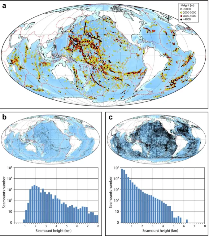
Size–frequency relationship of seamounts based on satellite and ship track data can be combined to estimate the total number of seamounts (Hillier and Watts, 2007). It is therefore speculated that there are 3–80 million seamounts greater than 100 m in height on the seafloor. The total number and global distribution of smaller seamounts, however, remains poorly constrained due to relatively limited coverage of the seafloor by echo sounding. Around 90 % of the seamounts, a fraction primarily including the smallest, <100 m-tall edifices, remain to be charted (Wessel et al., 2010). Only a very limited number of seamounts are currently included in open-source databases like the Seamount Catalog (http://earthref.org/SC/) or the General Bathymetric Chart of the Oceans (GEBCO, http://www.gebco.net/). There could be more than 50,000 seamounts taller than 1 km, representing only a minor fraction of the total seamount number (Fig. 1). Many of these larger seamounts are distributed along clusters or lines that can reach several thousands of kilometers in length (e.g., the Hawaiian–Emperor seamount chain in the NW Pacific). These seamount/island chains provide
important insights into plate motions, the formation of oceanic intraplate volcanoes, and the dynamics of the oceanic lithosphere and underlying mantle.
Origins
Most seamounts are formed by igneous activity close to mid-ocean ridges, island arcs, or in mid- plate settings (Koppers and Watts, 2010). Due to percolation of fluid-rich material through the upper plate, small mud or serpentine seamounts (volcanoes) can form between the volcanic arc and trench in intraoceanic subduction zones (Kopf, 2002). Blocks of continental crust, stranded during the opening of ocean basins, can form nonvolcanic seamounts (e.g., Stuttgart seamount around 1,000 km east of New Zealand, Mortimer et al., 2006).
Seamounts of igneous origin formed at mid-ocean ridges are called on-axis seamounts. Those formed within a few hundreds of kilometers of mid-ocean ridges on relatively young lithosphere, but not directly at the ridge axis, are commonly referred to as near-ridge or off-axis seamounts.
Estimates suggest that more than 50 % of seamounts are emplaced on oceanic crust younger than 20 Ma (Hillier, 2007), and, thus, on-/near-/off-axis seamounts probably compose the largest part of the seamount population. Even large seamount provinces, such as the Christmas Island seamount province in the northeast Indian Ocean (e.g., Hoernle et al., 2011) or the earlier Mid-Pacific Mountains in the central western Pacific Ocean (e.g., Hillier, 2007), are believed to have been formed in a near spreading center environment. Their emplacement is intrinsically related to upwelling beneath spreading centers and the formation of the oceanic crust.
Seamounts formed in mid-plate settings are called “oceanic intraplate volcanoes.” Intraplate volcanoes that are formed near spreading centers, i.e., on young and thus thin lithosphere, consist primarily of tholeiitic magmas (e.g., Niu et al., 2002). Most intraplate seamounts, however, are emplaced on older and therefore thicker lithosphere. These volcanoes comprise abundant alkaline igneous rocks that result from lower degrees of partial melting at greater depth compared to the production of tholeiitic volcanism. The formation of intraplate seamounts can be due to local melting anomalies or “hotspots” that underlie the lithosphere, plate cracking allowing preexisting melt in the upper mantle to rise to the surface (e.g., Natland and Winterer, 2005; Valentine and Hirano, 2010), or localized mantle upwelling in the shallow asthenosphere (e.g., Geldmacher et al., 2008). Hotspot volcanism is commonly associated with the presence of mantle plumes that bring hot, and thus buoyant, fertile mantle from a thermal boundary layer, such as the core–mantle or upper–lower mantle boundary, to the base of the lithosphere where the mantle melts. As the lithosphere moves over the plume, volcanism forms an age-progressive island/seamount chain (Morgan, 1972). The most prominent and thus well-known example of hotspot/plume volcanism is the Hawaiian–Emperor island/seamount chain, where seamounts become progressively older with increasing distance from the active volcanoes forming the Hawaiian Islands (Clague and Dalrymple, 1987). Seamounts can also form along cracks resulting from stress in the oceanic lithosphere, e.g., as a result of plate cooling, plate bending outboard of subduction zones, collision of continental blocks, or abrupt changes in plate motions (Natland and Winterer, 2005; Valentine and Hirano, 2010). Petit- spot volcanoes near Japan and Pliocene volcanism on Christmas Island near Indonesia, for example, formed outboard of subduction zones due to plate bending (Hirano et al., 2006; Hoernle et al., 2011). Plate cracking formed by extension can not only facilitate the rise of melts through the lithosphere but also can trigger asthenospheric upwelling causing decompression melting (O’Connor et al. 2015). Because seamounts are generally formed by lower degrees of partial melting and over a larger range of melting than normal mid-ocean ridge basalts (MORB), their igneous rocks exihibit a much larger spectrum of chemical compositions than MORB, since they preferentially sample fertile anomalies in the asthenospheric mantle (e.g., Niu et al., 2002; Hoernle et al., 2011). Seamount volcanism has played an important role in our understanding of mantle dynamics, chemical heterogeneity of the mantle, and magmatism in general.
Formation and Evolution
Seamounts are formed by eruptive and intrusive products with an estimated ratio of approximately 70:30 (Staudigel and Clague, 2010; Flinders et al., 2013). Eruptive products broadly include pillow
lavas that reflect low to medium effusive rates in submarine environments, massive sheet flows formed at higher effusive rates, and volcaniclastics formed through disaggregation of pillows or sheet flows on steep slopes or through explosive volcanism. Intrusive products generally consist of dikes, sills, and gabbroic to ultramafic rocks. The growth of a seamount is controlled by successive stacking of eruptive products and inflation due to emplacement of intrusives. Explosive volcanism occurs when the magma interacts explosively with water or when the magma rapidly outgasses in response to a decrease of pressure. Degassing of CO2 can occur at great pressure and can lead to explosive volcanism in the deepest parts of the ocean. Overall, the style of submarine eruptions reflects variation in the composition, physical properties, and supply rate of magma, as well as the tectonic setting of formation of the volcanic edifice (Rubin et al., 2012). Volcanoes several kilometers tall can form over hundreds of thousands of years (Clague and Dalrymple, 1987), whereas smaller seamounts may form in days to months.
Large seamounts follow a particular pattern of evolution primarily controlled by the relative intensity of magma supply and erosional processes through time. This pattern of evolution can be subdivided into six main phases (Staudigel and Clague, 2010):
1. A small seamount forms during incipient volcanism after a possible phase of magma interaction with seafloor sediments. The magmatic plumbing system of the volcano is restricted within the oceanic crust. Commonly, the magma supply wanes quickly and the seamount remains small.
2. More rarely, the seamount will experience continued or increased volcanic activity that results in formation of a much larger volcano. The magmatic plumbing system migrates upward within the volcanic structure.
3. When the summit of the seamount approaches sea level, explosive volcanism becomes more abundant. The amount of clastic deposits emplaced on the volcano slopes increases. The seamount emerges and forms an island when the eruption rate is high enough to overcome erosion by sea-surface waves, mass wasting, eustatic changes, and subsidence due to isostatic adjustment of the lithosphere under the fastgrowing seamount.
4. The seamount goes through a subaerial, island phase with continued volcanism. Incipient carbonate reefs can develop along the shorelines.
5. The main magmatic phase ceases and the island volcano stops growing and starts to erode.
Slope failure can lead to removal of major parts of the volcanic edifice with the potential for tsunami formation; such events may occur throughout the evolution of the seamount (Masson et al., 2006). The volcano can go through a period of quiescence for several million years until small volumes of lava are erupted during short periods of volcanic rejuvenation.
Continued erosion eventually leads to formation of a flat-topped to slightly dome-shaped (if subsidence occurs during erosion) seamount with a plateau just beneath wave base. As the volcano is cut off, i.e., moved away, from its with a plateau just beneath wave base. As the volcano is cut off, i.e., moved away, from its heat/magma source, lithospheric cooling leads to subsidence of the “guyot” seamount to depths up to thousands of meters below sea level.
Under appropriate environmental conditions, carbonate reefs can develop on top of the volcano and form an atoll, while the top is still in shallow water. The atoll becomes submerged when the growth of the reef can no longer compensate for seamount subsidence and/or sea level rise. The location at which an atoll drowns is sometimes referred to as the “Darwin Point” (e.g., Flood, 2001).
6. Most seamounts are ultimately transported to subduction zones, where flexure of the downgoing plate and the formation of bending-related faults can cause partial collapse of the volcanic edifice. During subduction, the seamount and related collapse products can be accreted (transferred to) and preserved in the accretionary wedge of a subduction zone (Hoernle et al., 2002; Portnyagin et al., 2008; Buchs et al., 2011). If not accreted, seamounts can contribute to the petrogenesis of arc magmas (e.g., in Central America, Hoernle et al., 2008).
Architecture and Structure
Crustal structure derived from seismic surveys reveals insights into the melt generation and the internal architecture of volcanic seamounts. The architecture of a seamount can be revealed using a structural comparison between an intraplate seamount and normal oceanic crust, using the correlation between P-wave velocity structure of seamounts and typical oceanic crust. Since non- explosive extrusive processes prevail during the deepwater stage, dominantly producing pillow basalts (~75 %) (Staudigel and Clague, 2010), the seismic velocity structure of small seamounts of
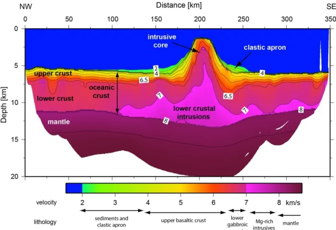
<1,000 m roughly mimic thickened oceanic crust. However, tall edifices show average P-wave velocities, which are significantly lower than those generally found in oceanic crust. The low velocities found in the uppermost crust beneath the summits and the clastic aprons of tall seamounts (Fig. 2) are indicative of low densities and high porosities, consistent with shoaling sequences composed dominantly (~70 %) of clastic deposits (Staudigel and Clague, 2010).
Accumulation of large volumes of clastic material in the summit region and upper flanks of a seamount volcano can generate debris flows that contribute to the clastic apron around the volcano and can extend into the abyssal plains beyond the apron. Some of the individual debris avalanches are 100–200 km long and 100–500 km3 in volume (e.g., Watts and Masson, 1995). Apron sediments may extend out to several hundreds of kilometers from a seamount or ocean island (e.g.,Wolfe et al., 1994). On the summit and flanks, clastic sediments and rocks show low seismic velocities of 2.8–
3.2 km/s (Weigel and Grevemeyer, 1999; Contreras-Reyes et al., 2010), but can also reach velocities of 4.0–5.0 km/s in the deep portions of the moat around the volcano (Wolfe et al., 1994; Weigel and Grevemeyer, 1999).
Below the summit, the transition to rocks with velocities of >6.5 km/s occurs generally at 2–4-km depth (Weigel and Grevemeyer, 1999; Contreras-Reyes et al., 2010), indicating the presence of gabbroic rocks and hence a central conduit or a plutonic suite (Fig. 2). Seismic velocities exceeding 7.0–7.2 km/s in the lower crust beneath seamounts suggest that significant proportions of magma feeding seamounts are trapped, i.e., intruded, near the base of the crust (White and McKenzie, 1989; Holbrook, 1995). The highmagnesium basalts generated from abnormally hot mantle typically exhibit high densities and hence velocities when they crystallize (White and McKenzie, 1989;
Keleman and Holbrook, 1995). The base of the crust forms a marked density contrast, so it is likely that melts generated at depth will accumulate near the base of the crust, where they either underplate the crust or intrude it as sills. High-velocity, lowercrustal rocks are an integral part of large seamounts, including the Hawaiian chain (Watts et al., 1985), Ninetyeast Ridge (Grevemeyer et al., 2001), and Louisville seamounts (Contreras-Reyes et al., 2010).
Implications for Topographic Anomalies on the Seafloor
The morphology of seamounts in the oceans controls several processes of global significance.
Seamounts play an important role in influencing local and global oceanic currents by redistributing the energy from surface tides, blocking water flow and creating eddies, and generating hydrothermally induced plumes in the water column (Lavelle and Mohn, 2010). For example, it was suggested that the New England Seamount chain in the Northern Atlantic can induce gyres with a stabilizing effect on the dynamics of the Gulf Stream (Ezer, 1994).
Large subducting seamounts can substantially modify the geometry of the plate interface at convergent margins, causing indentations in margins. They can locally “jam” subduction zones, trigger earthquakes or modify regional patterns of seismicity (Watts et al., 2010). They may also influence the patterns of fluid release in the subduction zone by creating preferential circulation paths within the deforming upper plate.
Seamounts represent areas of the ocean floor where the volcanic basement outcrops above the relatively impermeable layer of pelagic sediments on the seafloor. They therefore serve as preferential areas of recharge and discharge for hydrothermal fluids and permit extended exchange of heat and solutes between the ocean and the igneous crust (Fisher and Wheat, 2010).
Seamounts host a large variety of mineral deposits, including hydrogenous ferromanganese crusts (Fe–Mn crusts) or nodules, hydrothermal iron and manganese oxides, hydrothermal sulfide, sulfate and sulfur deposits, and phosphorite deposits (Hein et al., 2010). Formation of these mineral
deposits is related to hydrothermal, diagenetic, or precipitation processes that take advantage of magmatic heat. As the supply of some critical metals on land becomes more challenging (mining moves to greater depths and/or to more remote locations) or inaccessible for political or environmental reasons, these resources become more expensive, and new techniques to explore and mine the seafloor are currently being developed. The exploitation of mineral resources at seamounts will no doubt become economically advantageous at some stage in the future.
Volcanic islands and atolls constitute particular habitats that can remain isolated from major landmasses for tens of millions of years. This isolation fosters development of endemic taxa, which stimulated the postulation of the theory of natural selection in the nineteenth century. Similarly, seamounts (or submerged parts of oceanic islands) form barriers for ocean currents, causing upwelling of deeper nutrient-laden waters that supply sustenance for a wide range of marine organisms. Larger fauna, e.g., fish, feeds on the smaller organisms, and thus seamounts serve as oases for life in the ocean (Clark et al., 2010). Interestingly, the location of seamounts can often be inferred from the presence of large numbers of seabirds feeding off fish above the seamount.
Understanding the exact nature of biodiversity and fauna connectivity on seamounts, however, is still limited due to spatially and temporally restricted sampling. Fishing and trawling has caused substantial damage to some seamount habitats, and monitoring is needed to permit sustainable development of anthropogenic activities at seamounts.
Lithospheric Flexure Beneath Seamounts
Seamounts define loads that deform the oceanic lithosphere on which they sit. It has been shown that seamounts emplaced on young oceanic crust are characterized by local Airy-type isostasy (Watts, 2001), similar to icebergs floating in the ocean. With increasing age, however, the oceanic lithosphere becomes stronger, and rather than forming a local rootlike structure, it deforms elastically by flexure, like an elastic plate. The Dutch geophysicist and geodesist Felix Vening Meinesz introduced the effective elastic thickness (Te), to describe the deformation of the lithosphere. Thus, loads emplaced on older lithosphere are compensated regionally (see Fig. 2), causing prominent flexural moats and bulges along major seamounts chains, like the Hawaiian–Emperor seamounts (Watts, 1978). Oceanic settings provide Te values ranging from zero (Airy-type isostasy) to 40 km.
Since the oceanic crust is approximately 6 km thick, it is clear that not only the crust but also the lithospheric mantle is involved in supporting the load of seamounts (Watts, 2001).
Seamounts and True Polar Wander
Paleomagnetic data from seamounts support a mobile Earth and hence plate tectonics. Assuming that the Earth’s magnetic field is aligned with the spin axis, paleomagnetic data from volcanic and sedimentary rocks allow the reconstruction of the location of the magnetic pole. In the past 5 Myr, the geomagnetic field was axial geocentric dipolar within confidence limits of ~3° (Merrill and McElhinny, 1983). However, in older geological time intervals, the geomagnetic pole from a given region seems to move away from the spin axis (Creer et al., 1954) and is called apparent polar wander (APW). APW paths are composed of two components: plate motion and polar wander. Polar wander is the shift of the entire Earth with respect to the rotation axis. On an Earth where plates are constantly moving, it is difficult to define a reference frame. Therefore, true polar wander (TPW) has been introduced as a definition of polar wander, where paleomagnetic poles are viewed in a fixed hotspot reference frame (e.g., Besse and Courtillot, 1991). However, measurement of the paleomagnetism of samples from the Hawaiian–Emperor seamount chain, i.e., volcanic track formed above the Hawaiian hotspot, provided evidence for a significant southward motion of the Hawaiian mantle plume from 81 to 47 Myr ago. This motion was a dominant factor causing the trend and morphology of the Hawaiian–Emperor chain and the famous bend, i.e., change in orientation, of the Hawaiian hotspot at ~47 Ma (Tarduno et al., 2003; O’Connor et al., 2015). Tarduno (2007) concluded that “an important corollary of this finding is that true polar wander (i.e., polar wander calculated in a fixed hotspot reference frame) is illusory; the solid Earth has been relatively stable with respect to the spin axis for at least the past 130 million years. The paleomagnetic data from the Hawaiian–
Emperor tracks, and other oceanic sites, indicate that the geometry of hotspot tracks contains a rich history of both mantle flow and plate processes.”
Summary and Conclusion
Millions of seamounts on the seafloor have a large, multidisciplinary significance. Seamounts can provide constraints on the tectonic evolution of the seafloor and serve as a window into mantle compositional heterogeneity and dynamics. They can cause significant hazards for coastal populations by triggering earthquakes during subduction or tsunamis during major flank collapse.
Seamounts can host extensive hydrothermal activity and mineral resources of increasing significance to a planet with an exploding population growth. They are morphologic oases in the deep sea serving as stepping stones for marine biota. Clearly, there is a strong need for additional seamount research, and it is expected that forthcoming decades will see significant advances in our understanding of one of the most common but least studied features on Earth.
Acknowledgement
We thank Anthony Watts for his constructive and insightful review.
Bibliography
Batiza, R., Fornari, D. J., Vanko, D. A., and Lonsdale, P., 1984. Craters, calderas, and hyaloclastites on young Pacific seamounts. Journal of Geophysical Research, Solid Earth, 89, 8371–8390.
Besse, J., and Courtillot, V., 1991. Revised and synthetic apparent polar wander paths of the African, Eurasian, North-American and Indian plates, and true polar wander since 200 Ma. Journal of Geophysical Research, 96, 4029–4050.
Buchs, D. M., Arculus, R. J., Baumgartner, P. O., and Ulianov, A., 2011. Oceanic intraplate volcanoes exposed: example from seamounts accreted in Panama. Geology, 39, 335–338.
Clague, D. A., and Dalrymple, G. B., 1987. The Hawaiian-Emperor volcanic chain, Part I, Geologic evolution. InWright, T. L., Stauffer, P. H., and Decker, R.W. (eds.), Volcanism in Hawaii.Washington:
U.S. Government Printing Office, Washington: US Geological Survey Professional Paper 1350. pp.
5–54.
Clark, M. R., Rowden, A. A., Schlacher, T., Williams, A., Consalvey, M., Stocks, K. I., Rogers, A. D., O’Hara, T. D., White, M., Shank, T. M., and Hall-Spencer, J. M., 2010. The ecology of seamounts:
structure, function, and human impacts. Annual Review of Marine Science, 2, 253–278.
Contreras-Reyes, E., Grevemeyer, I.,Watts, A. B., Planert, L., Flueh, E. R., and Peirce, C., 2010. Crustal intrusion beneath the Louisville hotspot track. Earth and Planetary Science Letters, 289(3–4), 323–
333.
Creer, K. M., Irving, E., and Runcorn, S. K., 1954. The direction of the geomagnetic field in remote epochs in Great Britain. Journal of Geomagnetism and Geoelectricity, 6, 163–168.
Ezer, T., 1994. On the interaction between the Gulf stream and the New England seamount chain.
Journal of Physical Oceanography, 24, 191–204.
Fisher, A. T., and Wheat, C. G., 2010. Seamounts as conduits for massive fluid, heat, and solute fluxes on ridge flank. Oceanography, 23(1), 74–87.
Flinders, A. F., Ito, G., Garcia, M. O., Sinton, J. M., Kauahikaua, J., and Taylor, B., 2013. Intrusive dike complexes, cumulate cores, and the extrusive growth of Hawaiian volcanoes. Geophysical Research Letters, 40, 3367–3373.
Flood, P., 1999. Development of northwest Pacific guyots: general results from ocean drilling program legs 143 and 144. Island Arc, 8, 92–98.
Flood, P. G., 2001. The “Darwin Point” of Pacific Ocean atolls and guyots: a reappraisal.
Palaeogeography, Palaeoclimatology, Palaeoecology, 175, 147–152.
Geldmacher, J., Hoernle, K., Kl€ugel, A., van den Bogaard, P., and Bindeman, I., 2008. Geochemistry of a new enriched mantle type locality in the northern hemisphere: implications for the origin of the EM-I source. Earth and Planetary Science Letters, 265, 167–182.
Grevemeyer, I., Flueh, E. R., Reichert, C., Bialas, J., Klaeschen, D., and Kopp, C., 2001. Crustal architecture and deep structure of the Ninetyeast Ridge hotspot trail from active-source ocean bottom seismology. Geophysical Journal International, 144, 414–431.
Hein, J. R., Conrad, T. A., and Staudigel, H., 2010. Seamount mineral deposits. Oceanography, 23(1), 184–189.
Hess, H. H., 1946. Drowned ancient islands of the Pacific Basin. American Journal of Science, 244, 772–791.
Hillier, J. K., 2007. Pacific seamount volcanism in space and time. Geophysical Journal International, 168, 877–889.
Hillier, J. K., and Watts, A. B., 2007. Global distribution of seamounts from ship-track bathymetry data. Geophysical Research Letters, 34, L13304.
Hirano, N., Takahashi, E., Yamamoto, J., Abe, N., Ingle, S. P., Kaneoka, I., Hirata, T., Kimura, J. I., Ishii, T., Ogawa, Y., Machida, S., and Suyehiro, K., 2006. Volcanism in response to plate flexure. Science, 313, 1426–1428.
Hirano, N., Koppers, A. A. P., Takahashi, A., Fujiwara, T., and Nakanishi, M., 2008. Seamounts, knolls and petit-spot monogenetic volcanoes on the subducting Pacific Plate. Basin Research, 20, 543–
553.
Hoernle, K. A., Bogaard, P. V. D., Werner, R., Lissinna, B., Hauff, F., Alvarado, G., and Garbe- Schönberg, D., 2002. The missing history (16–71 Ma) of the Galápagos hotspot: implications for the tectonic and biological evolution of the Americas. Geology, 30, 795–798.
Hoernle, K., Abt, D. L., Fischer, K. M., Nichols, H., Hauff, F., Abers, G., van den Bogaard, P., Heydolph, K., Alvarado, G., Protti, J. M., and Strauch, W., 2008. Arc-parallel flow in the mantle wedge beneath Costa Rica and Nicaragua. Nature, 451, 1094–1097.
Hoernle, K., Hauff, F., Werner, R., van den Bogaard, P., Gibbons, A. D., Conrad, S., and Muller, R. D., 2011. Origin of Indian Ocean seamount province by shallow recycling of continental lithosphere.
Nature Geoscience, 4(12), 883–887.
Holbrook, W. S., 1995. Underplating over hotspots. Nature, 373, 559.
Keleman, P. B., and Holbrook, W. S., 1995. Origin of thick, high-velocity igneous crust along the U.S.
East Coast margin. Journal of Geophysical Research, 100, 10077–10094.
Kopf, A. J., 2002. Significance of mud volcanism. Reviews of Geophysics, 40, 1005.
Koppers, A. A. P., and Watts, A. B., 2010. Intraplate seamounts as a window into deep earth processes. Oceanography, 23(1), 42–57.
Lavelle, J. W., and Mohn, C., 2010. Motion, commotion, and biophysical connections at deep ocean seamounts. Oceanography, 23(1), 90–103.
Masson, D. G., Harbitz, C. B., Wynn, R. B., Pedersen, G., and Løvholt, F., 2006. Submarine landslides:
processes, triggers and hazard prediction. Philosophical Transactions of the Royal Society A:
Mathematical, Physical and Engineering Sciences, 364, 2009–2039.
Merrill, R. T., and McElhinny, M. W., 1983. The Earth’s Magnetic Field: Its History, Origin and Planetary Perspective. San Diego: Academic Press. pp. 401.
Morgan, W. J., 1972. Deep mantle convection plumes and plate motions. AAPG Bulletin, 56, 203–
213.
Mortimer, N., Hoernle, K., Hauff, F., Palin, J. M., Dunlop, W. J., Werner, R., and Faure, K., 2006. New constraints on the age and evolution of theWishbone Ridge, southwest Pacific Cretaceous microplates, and Zealandia-West Antarctica breakup. Geology, 34(3), 185–188.
Natland, J.H., and Winterer, E.L., 2005. Fissure control on volcanic action in the Pacific. In: Foulger, G.
R., Natland, J.H., Presnall, D.C., and Anderson, D.L. (eds.), Plates, Plumes and Paradigms. Boulder, CO: Geological Society of America, Special volume 388, pp. 687–710.
Niu, Y., Regelous, M., Wendt, I. J., Batiza, R., and O’Hara, M. J., 2002. Geochemistry of near-EPR seamounts: importance of source vs. process and the origin of enriched mantle component. Earth and Planetary Science Letters, 199, 327–345.
O’Connor, J., Hoernle, K., Butterworth, N.,M€uller, D., Hauff, F., Sandwell, D., Phipps Morgan, J., Jokat, W.,Wijbrans, J., and Stoffers, P., (2015) Deformation-related volcanism in the Pacific Ocean linked to the Hawaiian–Emperor bend. Nature Geoscience, 8, 393–397. DOI: 10.1038/NGEO2416.
Portnyagin, M., Savelyev, D., Hoernle, K., Hauff, F., and Garbe-Schönberg, D., 2008. Mid-Cretaceous Hawaiian tholeiites preserved in Kamchatka. Geology, 36(11), 903–906.
Rubin, K. H., Soule, S. A., Chadwick, W. W., Fornari, D. J., Clague, D. A., Embley, R. W., Baker, E. T., Perfit, M. R., Caress, D.W., and Dziak, R. P., 2012. Volcanic eruptions in the deep sea.
Oceanography, 25(1), 142–157.
Staudigel, H., and Clague, D. A., 2010. The geological history of deep-sea volcanoes. Oceanography, 23(1), 58–71.
Staudigel, H., and Schmincke, H.-U., 1984. The Pliocene seamount series of La Palma, Canary Islands.
Journal of Geophysical Research, 89, 11195–11215.
Staudigel, H., Koppers, A. A. P., Lavelle, J.W., Pitcher, T. J. P., and Shank, T. M., 2010. Defining the word “seamount”. Oceanography, 23(1), 20–21.
Tarduno, J. A., 2007. On the motion of Hawaii and other mantle plumes. Chemical Geology, 241, 234–247.
Tarduno, J. A., Duncan, R. A., Scholl, D.W., Cottrell, R. D., Steinberger, B., Thordarson, T., Kerr, B. C., Neal, C. R., Frey, F. A., Torii, M., and Carvallo, C., 2003. The Emperor seamounts: southward motion of the Hawaiian hotspot plume in Earth’s mantle. Science, 301, 1064–1069.
Valentine, G. A., and Hirano, N., 2010. Mechanisms of low-flux intraplate volcanic fields–Basin and Range (North America) and northwest Pacific Ocean. Geology, 38, 55–58.
Watts, A. B., 1978. An analysis of isostasy in the world’s oceans: 1. Hawaiian-Emperor seamount chain. Journal of Geophysical Research, 83, 5989–6004.
Watts, A. B., 2001. Isostasy and Flexure of the Lithosphere. Cambridge: Cambridge University Press, p. 458.
Watts, A. B., and Masson, D. G., 1995. A giant landslide on the north flank of Tenerife, Canary Islands. Journal of Geophysical Research, 100, 24487–24498.
Watts, A. B., ten Brink, U. S., Buhl, P., and Brocher, T. M., 1985. A multichannel seismic study of the lithospheric flexure across the Hawaiian-Emperor seamount chain. Nature, 315, 105–111.
Watts, A. B., Koppers, A. A. P., and Robinson, R. T., 2010. Seamount subduction and earthquakes.
Oceanography, 23(1), 166–173.
Wessel, P., 2001. Global distribution of seamounts inferred from gridded Geosat/ERS-1 altimetry.
Journal of Geophysical Research, 106, 19421.
Wessel, P., Sandwell, D. T., and Kim, S.-S., 2010. The global seamount census. Oceanography, 23(1), 24–33.
White, R. S., and McKenzie, D. P., 1989. The generation of volcanic continental margins and flood basalts. Journal of Geophysical Research, 94, 7685–7729.
White, R. S., MCKenzie, D. P., and O’Nions, R. K., 1992. Oceanic crustal thickness from seismic measurements and rare earth element inversions. Journal of Geophysical Research, 97, 19683 19715.
Wolfe, C. J., McNutt, M. K., and Detrick, R. S., 1994. The Marquesas archipelagic apron: seismic stratigraphy and implications for volcano growth, mass wasting, and crustal underplating. Journal of Geophysical Research, 99, 13591–13608.
Weigel, W., and Grevemeyer, I., 1999. The Great Meteor seamount: seismic structure of a submerged intraplate volcano. In Charvis, P., and Danobeitia, J. J. (eds.), Hotspot and Oceanic Crust Interaction. Journal of geodynamics, Vol. 28, pp. 27–40.
Figure 1. Seismic velocity structure of the Louisville seamount chain (Data from Contreras-Reyes et al., 2010)
Figure 2. Seismic velocity structure of the Louisville seamount chain (Data from Contreras-Reyes et al., 2010)