eas and academic debate. orking Papers series does not constitute publication and should not limit publication in any other venue. Copyright remains with the authors.
GIGA Research Unit:
GIGA Institute of Asian Studies
___________________________
Seeing from Above:
The Geopolitics of Satellite Vision and North Korea David Shim
No 201 August 2012
Edited by the
GIGA German Institute of Global and Area Studies Leibniz‐Institut für Globale und Regionale Studien
The GIGA Working Papers series serves to disseminate the research results of work in progress prior to publication in order to encourage the exchange of ideas and academic debate. An objective of the series is to get the findings out quickly, even if the presenta‐
tions are less than fully polished. Inclusion of a paper in the GIGA Working Papers series does not constitute publication and should not limit publication in any other venue. Copy‐
right remains with the authors. When working papers are eventually accepted by or pub‐
lished in a journal or book, the correct citation reference and, if possible, the corresponding link will then be included on the GIGA Working Papers website at
<www.giga‐hamburg.de/workingpapers>.
GIGA research unit responsible for this issue: Institute of Asian Studies Copyright for this issue: © David Shim
WP Coordination and English‐language Copy Editing: Melissa Nelson Editorial Assistance and Production: Silvia Bücke, Christine Berg
All GIGA Working Papers are available online and free of charge on the website
<www.giga‐hamburg.de/workingpapers>.
For any requests please contact:
E‐mail: <workingpapers@giga‐hamburg.de>
The GIGA German Institute of Global and Area Studies cannot be held responsible for errors or any consequences arising from the use of information contained in this Working Paper; the views and opinions expressed are solely those of the author or authors and do not necessarily reflect those of the Institute.
GIGA German Institute of Global and Area Studies Leibniz‐Institut für Globale und Regionale Studien Neuer Jungfernstieg 21
20354 Hamburg Germany
E‐mail: <info@giga‐hamburg.de>
Website: <www.giga‐hamburg.de>
Seeing from Above:
The Geopolitics of Satellite Vision and North Korea
Abstract
Satellite imagery plays an important role in contemporary geopolitics. Arguably the most well‐known example is Colin Powell’s (in)famous presentation to the UN Security Council in February 2003, during which he used satellite pictures to legitimate the invasion of Iraq.
Satellite photographs draw on a techno‐scientific discourse that enables them to function as undistorted records impartially documenting space and place. As a result, they assume a defining authority to “speak the truth” – which is probably enhanced with regard to (al‐
legedly) unknown and mysterious sites like North Korea. Since satellites are deployed to reveal what should be invisible, their ability to detect and expose, or “see from above,”
implies a particular power. However, satellite photographs are not necessarily objective re‐
flections of a geographical surface but, like all visual representations, underlie what will be called a logic of inclusion and exclusion that makes them deeply political. Taking North Korea as an example, the article argues for the need to develop a sensitized understanding concerning the use and function of satellite images as they often come to have internation‐
al political implications. Referring to the linkages between seeing, knowing and acting, the article examines the role of remote sensing as a way of knowing and inquires as to the immediacy of images and the ensuing imperative to respond to them.
Keywords: North Korea, visuality, critical geopolitics, satellite imagery
Dr. des. David Shim
is a postdoctoral research fellow at the GIGA Institute of Asian Studies. His research inter‐
ests include critical approaches to IR and the relationship between visuality and world politics. He is a member of Research Programme 4: Power, Norms and Governance in In‐
ternational Relations.
Contact: <david.shim@giga‐hamburg.de>
Website: <http://staff.en.giga‐hamburg.de/shim>
David Shim
Article Outline 1 Introduction
2 Visuality, Knowledge and Geopolitics 3 The Authority of Satellite Vision 4 The Geopolitics of Satellite Vision
5 North Korea: Terra Incognita and Practices of Looking 6 The Spatial Imaginary
7 Believing is Seeing 8 Conclusion
Bibliography
1 Introduction
In the contemporary geopolitical order, there are seemingly few states like North Korea.
Continuously made meaningful and problematized in terms of the political and the interna‐
tional, almost every aspect, area or action of this so‐called “pariah” or “rogue” state is said to have inherent political dimensions and international repercussions: be it the country’s do‐
mestic human rights situation, its precarious everyday life or its foreign policy of coercion and nuclear brinkmanship, no matter what North Korea says and does, it affects the state and stability of regional and global politics. While North Korea is in this sense unquestiona‐
bly an international subject, articulations of secrecy play a crucial role in descriptions of the
spaces and spatialities of the country. North Korea is often referred to as the most isolated place in the world, and particular imaginations or, to put it differently, certain imaginative geographies including that of a “terra incognita” (Solarz 1999), a “black hole” (Demick 2010) or a “land of no smiles” (Van Houtryve 2009) prevail in the portrayal of the country in inter‐
national relations.
Citing North Korea’s ambiguous and reclusive nature, government officials, scholars and journalists from other countries still struggle to understand North Korea’s state of affairs.
The country appears to be a perfect example of the quintessential other of modern globaliza‐
tion, something which defies closer scrutiny because it is unmapped, shrouded in secrecy and secluded from the rest of the world. Interestingly, this assessment is not new. As early as the 1970s, the then director of the Central Intelligence Agency (CIA), Robert Gates, who later served as US secretary of defense from 2006 to 2011, described North Korea as a “black hole”
and the “toughest intelligence target in the world” (cited in French 2005: xiii). One of the most recent examples of such statements was the blunt acknowledgment made by Kurt Campbell, Assistant Secretary of State, East Asian and Pacific Affairs, before the US Senate Armed Services Committee in September 2010. Responding to questions from the Senate panel concerning the security situation on the Korean peninsula, Campbell stated,
In fundamental ways, North Korea is still a black box. We have some glimpses and some intelligence and the like, but the truth is often times in retrospect some of that in‐
telligence has proven to be wrong. It’s a very, very hard target, probably the hardest target we face in the global arena. (cited in Stewart 2010)
Of central importance to these characterizations is the claim of missing information. What appears to be certain, both for then (Gates) and now (Campbell), is that North Korea remains unknown or is unknowable to the outside world. However, equally worthy of mention in this regard is the significance of certain practices for securing knowledge about the country in order to compensate for this paucity of information: visual representations – that is, satellite images. In particular, the implications of what we see – vision – and how we (are made to) see – visuality – are given analytical priority in the paper.
In this vein, the article pursues several goals: First, it shows how satellite images function as powerful spatial imaginaries which mediate a particular notion about a particular territory (see Dodge and Perkins 2009). This productive function is possible because seeing is viewed as an authoritative way of knowing. Second, by inverting the commonplace “seeing is believ‐
ing” to what can be termed “believing is seeing,” the article provides examples that question the authoritative relationship between seeing, knowing and acting. While the truthfulness or accuracy of satellite images is not challenged, the article asserts that it is essential to recog‐
nize that such pictures are not self‐evident: they alone do not tell us what they mean, what the “right” conclusions are or what has to be done. Third, it intends to advance critical stud‐
ies in geopolitics by empirically discussing a case that is arguably neglected in this field of
study: North Korea, or more precisely, the use of visual spatial representations of North Ko‐
rea. For instance, one strong thread in critical geopolitics is the focus on topics related to the US “War on Terror” (see for example Amoore 2007; Anderson 2010; Dodds 2007) or the war in Iraq (see for example Gregory 2010; Hyndman 2007; Ó Tuathail 2003). Critical engage‐
ments with the subject of North Korea are virtually nonexistent. Finally, this article points out a peculiar feature of remote sensing that is more often than not overlooked: satellite im‐
ages are artificial and authoritative at the same time. Because it indicates the different truth terrains on which other modes of the visual play (for example, documentary photography), the hybrid character of satellite imagery highlights the need to develop a careful understand‐
ing concerning its use and function.
The paper begins by explicating the role that satellite imagery is assigned within current geopolitical practices. To this end, it highlights the epistemological status of remote sensing as such ways of (remote) seeing are embedded within technological and scientific logics.
However, it is also demonstrates that satellite images, like all visual representations, are sub‐
ject to what will be called a logic of inclusion and exclusion (cf. Mirzoeff 1999): some things (are made to) lie within the satellite’s frame of vision, while others remain out of its view.
This logic makes satellite images political and open to appropriation. The paper discusses examples related to North Korea and concludes with the implications of its findings for the broader study of visuality in critical geopolitics.
2 Visuality, Knowledge and Geopolitics
Remote sensing has a broad range of applications in global politics. It is used, for instance, in armed conflicts, wars and humanitarian emergencies, as well as for international sanctions and drug prevention and environmental preservation efforts (see for example Baker, O’Connell, and Williamson 2001; Baker and Williamson 2006; Dodge and Perkins 2009). The academic analysis concerning the use of satellite imagery varies accordingly. Fields that study it include (critical) geopolitics, (critical) security studies, strategic studies, conflict stud‐
ies, environmental studies and humanitarian studies. Satellite pictures are deeply embedded in governmental, intelligence and military fact‐finding missions and decision‐making pro‐
cesses. Often they represent the main source of information used in, for instance, the evalua‐
tion of weapons (of mass destruction) programs and of proliferation activities on the part of states like North Korea and Iran (see Herman 1996). Satellite photographs are believed to reveal the stage of development of nuclear reactors and missile bases and to help monitor and track suspicious cargo vessels in international waters. The US‐led Proliferation Security Initiative, which seeks to create a global network to monitor, control and prevent the ship‐
ping of weapons of mass destruction, is one example of this.
A number of incidents demonstrate that satellite imagery has consistently and repeatedly
played an important role in international politics. Perhaps the most well‐known incident in
recent years was the invasion of Iraq by US‐led forces in March 2003, in which satellite im‐
agery – infamously presented by then US secretary of state Colin Powell at the UN Security Council – claiming to prove the existence of Iraqi weapons of mass destruction played a piv‐
otal role in the justification for starting the war. Other examples include the conflict in Bosnia in 1995, during US ambassador to the United Nations Madeleine Albright used satellite pho‐
tographs in her presentation to the UN Security Council to call attention to atrocities commit‐
ted against Bosnian Muslims and to provide evidence about the location of suspected mass graves near Srebrenica,1 and the air raid undertaken by Israeli fighter jets in 2007 against a Syrian facility that Jerusalem considered to be a nuclear reactor under construction.
The involvement of the UN Security Council is indicative of the overall dynamics to which images relate and are a part of, as satellite pictures have been central referents in mat‐
ters related to international peace and security. Against this backdrop, images appear to
“speak” security and function as instantaneous communicative acts (Hansen 2011; Williams 2003). In other words, images are not illustrative and, therefore, secondary to knowledge, but knowledge in their own right. In this vein, they are an integral part of geopolitical dynamics.
This not only makes them legitimate subjects of critical analysis but also highlights the need for careful engagement with the issues and implications of visual representations.
Moreover, the episodes described above also aptly summarize what is at stake in these practices of looking. They illustrate the immediacy of the images, the ensuing imperative to respond to them, and the reality that knowledge relies on vision. Remote sensing enables political actors to know what (they believe) another is up to and to act upon what they see or, and this is also important to consider, what they have been allowed to see by others.2 The case of satellite imagery is a prime example of the links between visuality, knowledge and geopolitics in that it reveals how geopolitical practices are tied to this way of (remote) seeing:
regarded as providing compelling evidence, these pictures allow governments to make legit‐
imate statements, draw conclusions and take political action.
3 The Authority of Satellite Vision
Traditionally, remote sensing has been the exclusive domain of the state. As a result, satellite images have typically been aligned with official forms of knowledge (Parks 2005). However, due to several developments in this domain – the privatization of the satellite industry, legis‐
lative amendments and technological innovations – satellite images have increasingly come
1 The photographs led the council to adopt Resolution 1010, which demanded that Bosnian Serbs respect the
rights of Bosnian Muslims and warned the Bosnian Serb military that they would be held accountable for vio‐
lations of international humanitarian law (Florini and Dehqanzada 2001: 437).
2 For instance, the International Atomic Energy Agency (IAEA), which uses satellite imagery, among other things, for its assessment of suspected nuclear programs, is often provided with (particular) images by other states, including the United States.
to be used by nonstate actors including civil society groups, nongovernmental organizations, journalists, scholars, aid workers and artists. The growing interest in and utilization of com‐
mercial satellite imagery has prompted some to argue that it has reshaped the ways in which these actors comprehend space and place (for example, Dodge and Perkins 2009; Aday and Livingston 2009; Parks 2009). Further, the simplicity with which these kinds of images can be viewed, used and disseminated has empowered different social groups to challenge sover‐
eign powers through the disclosure of clandestine sites under military or state control. Per‐
haps more important to note than the fact that states face new challenges from commercial or private satellite applications is that the visual is reconfiguring the geopolitical terrain itself:
remote sensing enables different groups to constitute themselves as political actors (see Han‐
sen 2011; see also Aday and Livingston 2009; Litfin 2001, 2002; Rosenau 2002). Examples are provided by advocacy networks such as the Institute for Science and International Security (ISIS) and human rights organizations like Amnesty International that regularly use satellite images to call attention to particular issues and to press governments to take action. For in‐
stance, human rights activists such as the US Committee for Human Rights in North Korea (Hawk 2003; 2012) repeatedly refer to overhead imagery of North Korean prison camps in an attempt to get the US government and international organizations to put North Korean hu‐
man rights at the top of their political agendas. The regular references made by the US State Department’s annual report on North Korean human rights to the accounts and imagery of nongovernmental organizations, refugees and the media shows how various actors partici‐
pate in and become part of governmental discourse (for example, US DOS 2010).
However, regardless of whether satellite imagery is used by government or nongovern‐
ment actors, what is important to note is that its function remains the same: giving authority to certain statements, conclusions and actions. This kind of use is possible because satellite images draw on a techno‐scientific discourse that endows them with what David Campbell (2007: 20) calls an “aura of unsurpassed objectivity.” The precision of high‐resolution pan‐
chromatic and multispectral images is the result of electro‐optical processes and innovations that allow satellite pictures to look like mimetic reflections of geographical surfaces. Sophis‐
ticated technology and its scientific application sustain the perception that remote‐sensing images impartially document places, spaces and sites. Seemingly stripped of subjective inter‐
ference, satellite images reveal traits similar to the genre of documentary photography: like the latter, they claim to offer transparent insights into major processes in the world and to provide their viewers with unmediated access to the truth. Furthermore, because geostation‐
ary satellites are capable of recording images at any time and from anywhere, they – in a way analogous to the all‐seeing eye of providence – are believed to transcend natural obstacles and elemental boundaries. Similarly to Walter Benjamin’s notion of photography as a tech‐
nology of the “optical unconscious,” satellite cameras expand human observation beyond its natural scope and extend the range of visible space (cf. Edwards 2006; Schwartz and Ryan 2003). Therefore, satellites seem to be capable of autonomous vision as they continuously
orbit and scan the earth (Marmor 2008). As a result they provide the observer with a privi‐
leged visual angle, one which not only purports to offer a synoptic view of a given landscape or territory but also gives the impression of inherent transparency and controllability and of dominance over what is being observed. In this regard, Dodge and Perkins (2009: 498, italics in original) assert that “satellite images appear to see more of the world, or at least the view‐
ers perceive they are seeing much more […] a fuller view of space; so that you think you can see things you would recognize with the naked eye.”
What is important to note is that satellites make visible what people cannot normally see.
Because they are able to reveal hidden, unknown or secret sites, which would otherwise re‐
main invisible and inaccessible to us, their ability to see from above implies a particular power (Perkins and Dodge 2009), a power that can be associated with the establishment of a particular imaginative geography, a specific notion of space and place. As optical devices, satellites not only define the visual appearance and cognition of specific sites, through, for instance, the practice of mapping, but also create imaginations of spatial order. For example, some authors have argued that the camera of the satellite has created a new way of looking, through the adoption of a perspective seen from outer space, which has not only established the icon of the blue planet but also helped to construct the earth as a unitary biosphere and a coherent ecological system (Siemer 2007; Sachs 1994; see also Cosgrove 1994; 2001).
4 The Geopolitics of Satellite Vision
The defining authority of satellite images is related to their political character. Even though they are understood to provide the observer, as stated above, with “a fuller view of space”
(Dodge and Perkins 2009: 498, italics in original), leading to the assumption that viewers are seeing much more, one cannot obscure the fact that these images are partial representations of space. No camera perspective can capture a scene in its entirety, because any attempt to represent reality involves selections and reductions. Images are, therefore, necessarily synec‐
dochic representations. They make a reference to the whole through a partial account. The partial character of satellite images points to the most powerful mechanism of the visual: the logic of inclusion and exclusion. Again, while the accuracy of such images is not challenged here, it is important to note that (satellite) imaging rests upon an understanding of what is entitled to representation and what is not, or upon an interpretive response to what deserves to lie inside and outside a satellite’s frame of visibility. By this means, images can help to erect hierarchies, create boundaries and sustain differences which separate, for instance, a “known”
from an “unknown,” a “domestic” from a “foreign,” or a simple “here” from a “there.”
The selectivity of satellite imaging gives cause to ask why specific photographs or visual motifs, and not others, are repeatedly presented and disseminated. For instance, even though intelligence agencies from both the United States and South Korea possess overhead imagery of North Korea’s forced‐labor camps, no image of them has ever been officially released. Cit‐
ing security reasons, the US government has objected to the publication of such pictures be‐
cause it allegedly does not want to disclose the reconnaissance capabilities of its satellites (Brooke 2003). The international public only learned about the existence of these prison com‐
pounds after, in December 2002, a series of satellite photographs appeared in the Far Eastern Economic Review, which had obtained the pictures from a commercial provider of space imag‐
ing (Larkin 2002). While reports and testimonies by North Korean refugees were available previously, they, as the Far Eastern Economic Review noted, “suffered from a key failing: no foreigners have ever seen the North Korean camps” (Larkin 2002: 15). The December 2002 publication was the first time that photographs of the North Korean labor camps were made public.3 Further images were made available in October 2003 – and, more recently, in April 2012 (Hawk 2012) – when the nongovernmental US Committee for Human Rights in North Korea released a report that provided visual evidence of the existence of these camps (Hawk 2003). What is striking is the fact that since the 1990s high‐resolution satellite pictures of North Korea’s nuclear and missile sites have frequently been released and referred to by US administrations, thereby contradicting the claim that accurate reconnaissance imagery should not be shown to the public for security reasons.
Concerning the question of why satellite images of North Korea’s nuclear and missile fa‐
cilities are readily released by governments but those of the country’s notorious prison com‐
plexes are not, we must ask whether such images are a means to a particular end – that is, whether they serve certain political purposes. For, as Lisa Parks (2001) argues, satellite pho‐
tographs assume importance only when they have relevance in current international affairs.
Thus, the (comparative) invisibility of these camps is no surprise given the dominance of one geopolitical issue in the Northeast Asian security discourse since the mid‐1990s: North Ko‐
rea’s nuclear and missile program.4 Parks (2001: 597) states that the “satellite’s gaze is trained on particular places for particular reasons [that] […] can be mobilized as representing the ultimate authority of the state […] or as a completely abstract and uncertain point of view.”
So what should be considered a characteristic feature of satellite images is that they can ei‐
ther be utilized as compelling sources by various actors or be seen as signifying nothing but a view from outer space.
However, there are also other aspects of satellite imagery that reveal its inclusionary and exclusionary logics. They bring to light the fact that remote sensing is not an innocent mode of representation but is rather open to political appropriation and manipulation. While satel‐
3 The photographs were so detailed that a former guard had no trouble pinpointing his place of work. He not‐
ed, “this is definitely it […] I finished my shift at 2 a.m. Then I drove my truck along this road to the railway station you see there, and followed the road to the Chinese border” (Larkin 2002: 15).
4 However, several developments in recent years have pointed to increasing political commitments and interna‐
tional attention regarding the (human rights) situation in North Korea. These include the enactment of specific human rights‐related laws, the appointment of special emissaries and the growing condemnation of North Korea’s human rights violations by national governments and international bodies.
lite images are commonly assumed to be visual evidence, they are far from being self‐evident and do not speak for themselves. Revealing in this regard were the remarks made by Colin Powell when he presented satellite images of Iraq to the United Nations Security Council in order to make the case for a military invasion:
Let me say a word about satellite images before I show a couple. The photos that I am about to show you are sometimes hard for the average person to interpret, hard for me.
The painstaking work of photo analysis takes experts with years and years of experi‐
ence, poring for hours and hours over light tables. But as I show you these images, I will try to capture and explain what they mean, what they indicate to our imagery spe‐
cialists. (Powell 2003)
While the war in Iraq illustrates how satellite images can be used for manipulative purposes, it also shows that such strategies of deception are enabled precisely as a result of the images’
opacity and ambiguity – that is, because pictures lack any inherent meaning. To understand how such images function, it is useful to outline how satellite vision is manufactured and mediated and how it interacts with text and language in the creation of meaning.
The impression that satellite photographs are transparent mediators obscures the com‐
plex technical processes that accompany their production. Before they can be presented and viewed in a meaningful way, satellite images are computer‐processed in order to correct dis‐
tortions and to give them their proper visual appearance (Dodge and Perkins 2009; Campbell 2007; Parks 2001; 2005). Often they are compiled out of parcels of shots from different times;
this creates a “genuine” view of a given surface, free from cloud cover. Thus, satellite images originate from a particular day and from a particular time. The synthetic imaging process is due to the vast amounts of data involved. These are transmitted through the electro‐optical sensors of satellites to terrestrial stations, where they are converted into a visual form of analysis (Marmor 2008: 318). However, much of what satellites capture is rarely analyzed and is more often than not archived. Satellite data becomes real – a photograph – only after it is sorted, arranged and circulated (cf. Campbell 2007). Perhaps because of this, satellite im‐
ages, more than any other photographic representation, demand (professional) interpretation (Parks 2005).
Indeed, the analysis of satellite images appears to be a matter of expert knowledge, as a distinct body of work and institutions suggests (for example, Conway and The Maryland Space Grant Consortium 1997; Philipson 1997; Campbell 1996; Baker 2001; Lillesand, Kiefer and Chipman 2008). A common example of this is provided by satellite weather photo‐
graphs, which have to be interpreted by meteorologists so that a lay audience can under‐
stand them properly. Important stakeholders in the production and dissemination of this expert knowledge are professional associations and international imagery training centers such as the International Society for Photogrammetry and Remote Sensing or the Interna‐
tional Institute for Aerospace Survey and Earth Sciences. The examination of satellite photo‐
graphs for the purpose of detecting specific objects and evaluating their significance is based on a number of (visual) methodological categories. These comprise, for instance, the location, size, shape, color, texture and pattern of depicted objects (Baker 2001: 537). At the National Photographic Interpretation Center, which is run by the US government, over one thousand imagery analysts and specialists work on photographs to decode and make sense of them (Campbell 2007: 22).
Various accompanying explanations and captions, as well as other graphic and technical tools, not only ensure that satellite images are accessible to a wider audience but also make these pictures comprehensible in a particular way, which in turn narrows the possibilities for how they can be understood. The processing of satellite images embeds them in what Parks (2001: 592) calls “a broader economy of tele‐visual signs.” This embeddedness refers to the signifying function of the captions, narrations and arrows that are always attached to these photographs. Since satellite images do not inherently indicate how they should be read, the interweaving of such photographs into a larger context of other signs tells the viewer how they have to be interpreted. Similarly to a visual manual or a set of visual instructions, the accompanying marks direct the viewer to see what the presenter wishes to make visible, thereby reducing the number of possible meanings.
5 North Korea: Terra Incognita and Practices of Looking
As indicated above, references to secrecy pervade various parties’ approaches to North Ko‐
rea. Often described as an “enigma” (Halliday 1981) or a “mystery” (Scalapino 1997), North Korea is widely believed to be a secret of its own kind. It remains unseen and is hidden from view. Since satellites are deployed to reveal what should be invisible, detecting and exposing the hidden or, in other words, seeing (from above) implies a particular power (Perkins and Dodge 2009). A number of examples show that satellite imagery plays a decisive role in ex‐
posing North Korea’s secret(s) (see for example Brown 2009, Daily Telegraph 2010; Kim T. H.
2010; Ramstad 2009, Yang 2008; Yoo 2010). What should also be considered is that such imag‐
es may hold a greater authority to “speak” about (allegedly) unknown places and mysterious sites because they – like the eye of providence – help us to see and, therefore, to know what is
“really” going on.
From the status of its nuclear or missile developments, to its weapons proliferation or overseas trade activities, to its food security or human rights situation, satellite images tell us what is happening in and around Korea. For instance, the UN’s World Food Programme and its Food and Agriculture Organization have regularly assessed North Korea’s crop and food supply by studying satellite photos of its fields (for example, FAO and WFP 2004). Satellite imagery is also important in estimating North Korea’s vegetation and crop‐growing condi‐
tions. Based on the estimates they derive from these sources, these UN agencies appeal to international donors for food aid. Satellite pictures were also used by international relief or‐
ganizations to assess the extent of the damage caused by a train explosion in Ryongchon in April 2004, and to evaluate the scale of destruction resulting from super typhoon Bilis, which hit North Korea in July 2006. Remote‐sensing images have also been used to assess North Korea’s alleged involvement in the state‐sponsored production and global distribution of illegal narcotics (see Sovacool 2009).
6 The Spatial Imaginary
People come to know the world – and its spaces and places – through visual imagery. Un‐
known locations are made familiar through visual representation (cf. Schwartz and Ryan 2003). Satellite images are one of the ways in which people approach and engage with the world – that is, how they imagine the places and sites of the world. Because they are a means of mapping, watching, ordering and representing the world, satellite images are a pervasive form of geographical knowledge; they make the world knowable. As such they contribute to shaping particular spatial imaginaries.
In terms of visual composition, almost all satellite images reveal similar representational patterns, as they provide a vertical and planar view from above the earth’s surface. Exhibit‐
ing features of landscape photography and landscape painting, satellite images tend to cap‐
ture broad territorial spaces within a single frame and convey an enhanced sense of pictorial realism, overt naturalism and colorful diversity (Dodge and Perkins 2009: 498). Like the gen‐
re of landscape photography, satellite imagery permits viewers to control, order and scale a territory into neatly arranged portions (Clarke 1997: 55, 61). As a result, the satellite image appears as a natural map of an area – one which claims to represent the truth on the discur‐
sive authority of cartography and geography.
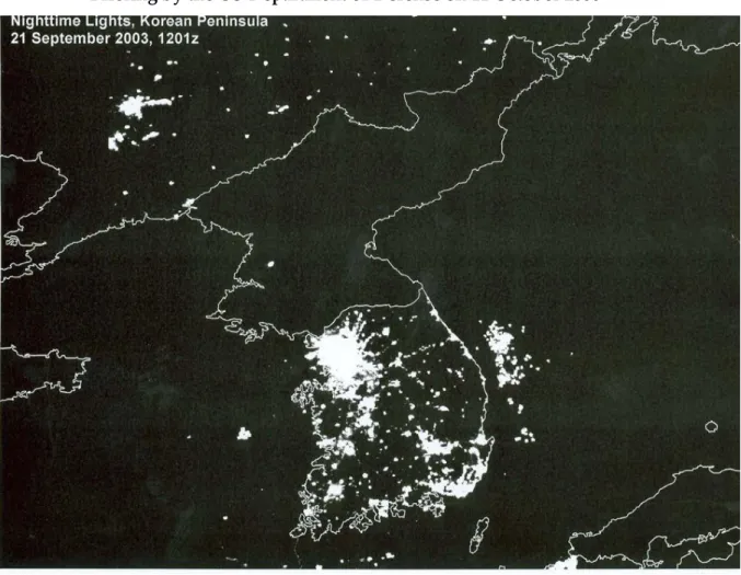
With regard to North Korea, one satellite image, or more precisely, one visual motif is widely and frequently used (see Figure 1). It shows the Korean peninsula at night; most of the bright spots are located in the south, while the northern part is almost entirely in the dark. Other versions of the picture include the Japanese islands and parts of Northeast China and Russia, all of which are illuminated (see for example GlobalSecurity.org 2006). The motif gained prominence when the US Department of Defense included the satellite photo in its standard briefings on North Korea under the tenure of Donald Rumsfeld (GlobalSecurity.org 2006). The same picture or similar versions of it have been referred to or reproduced in aca‐
demic publications (for example, Kim S. 2002; Knaus and Lee 2011; Harris 2007) and media outlets such as the New York Times (Zeller 2006), the British Daily Mail (2006), the Washington Post (Klein 2011) and South Korea’s largest newspaper Chosun Ilbo (2010). Some economists have even used this image to establish a causal link between the luminosity that is the visibil‐
ity of nighttime light and economic growth (see for example Henderson, Storeygard and Weil 2009; see also Chen and Nordhaus 2011). However, the academic use of this photo is not
the only example that exposes the nexus between certain kinds of visualities and certain kinds of knowledges.
Figure 1: Satellite Photo Showing the Korean Peninsula by Night, Used During a News Briefing by the US Department of Defense on 11 October 2006
Source: GlobalSecurity.org 2006.
In order to ascertain what this visual motif is believed to signify and, therefore, how North Korea is imagined, it is helpful to examine the statements that have been provoked by this way of seeing. During a news briefing at the US Department of Defense in December 2002, Rumsfeld stated,
If you look at a picture from the sky of the Korean Peninsula at night, South Korea is filled with lights and energy and vitality and a booming economy; North Korea is dark. It is a tragedy what’s being done in that country. And the suggestion that it is a result of rhetoric from outside I think is – misses the point. We have a very strange sit‐
uation in that country. (US DoD 2002)
During another news briefing, shortly after North Korea had conducted its first nuclear test in October 2006, Rumsfeld referred once again to this image:
Except for my wife and family, that is my favorite photo. It says it all. There’s the south of the Demilitarized Zone, the same people as north, same resources north and south,
and the big difference is in the south it’s a free political system and a free economic sys‐
tem […] that dot of light is Pyongyang. And the people there are starving and their growth is stunted. And it’s a shame. It’s a tragedy. (US DoD 2006)
One of the latest examples of the use of this image is the book Nothing to Envy: Ordinary Lives in North Korea by Los Angeles Times journalist Barbara Demick (2010), who was awarded the 2010 BBC Samuel Johnson Prize for Non‐Fiction for this work. She introduces her book with a version of this satellite picture, stating,
If you look at satellite photographs of the Far East by night, you’ll see a large splotch curiously lacking in light. This area of darkness is the Democratic People’s Republic of Korea. Next to this mysterious black hole, South Korea, Japan, and now China fairly gleam with prosperity. […] In the middle of it all [there is] an expanse of blackness nearly as large as England. It is baffling how a nation of 23 million people can appear as vacant as the oceans. North Korea is simply a blank […] a country that has fallen out of the developed world. (ibid.: 3–4)
It is important to note that the truthfulness of the satellite image or the validity of the read‐
ings of it is not questioned here; nonetheless, the picture is used to establish a particular spa‐
tial imaginary. The site North Korea is particularly marked in terms of absence, deficiency and scarcity. It is pictured according to what it does not have: light, prosperity, freedom, food and hope. It lacks visibility, vitality and prosperity. The pictorial contrast between bright and dark and black and white underpins readings that foreground difference, distance and oth‐
erness over what can be called affinity, familiarity and sameness. North Korea is literally im‐
agined as a black hole, an image that for many is an allegory for its unique role in the current geopolitical order. It is an isolated, backward and mysterious place, which its people can only run away from; it is a site that must be abandoned because it is outside of the modern world, even outside of time, incapable of change and entrapped in an eternal past. From this representation, it becomes clear what North Korea is not: home – a special place of belonging that comprises the experiences, emotions, values and social relationships that make up the very essence of a human being (cf. Gregory et al. 2009: 339).
Also noteworthy is the fact that certain constructed (in)visibilities establish the conditions according to which meaningful statements and conclusions about places, spaces and sites can be made: that what can(not) be seen determines what can(not) be known and said about a locality. Another crucial point is that the subject of the photo is understood to “speak” inse‐
curity and difference (for example, as Rumsfeld states, “It says it all”). It does not communi‐
cate any cartographic knowledge, which is one of the most essential assets of remote sensing, but is rather implicated in a particular imaginative geography: North Korea as the place of the great unknown in world politics, a place beyond the realm of comprehension that is nei‐
ther part of our world nor part of our time.
The repeated use and circulation of this visual motif – North Korea in darkness – in aca‐
demia, politics and media demonstrate its overarching popularity as an iconic geography.
That is to say, the photo’s subject functions as an imaginative signifier rather than as a carto‐
graphic referent. This form of visuality is also hegemonic as it marginalizes alternative modes of representation and determines whose and what kinds of perspectives are meaning‐
ful. For instance, the constructed visibility of this photograph would take on a different meaning when interpreted according to an environmental discourse that problematizes not the lack of light but, on the contrary, its excessive application and the damage it causes to natural ecosystems and physical health (“light pollution”). Also, satellite images taken of the Korean peninsula during the day would not serve the specific purpose of speaking insecurity and emphasizing difference, as the nighttime pictures do, because they could not display the necessary visible or metaphorical disparities between North Korea and its neighbors. In this vein, it is not surprising that daytime images of the Korean peninsula are almost nonexistent while nighttime pictures are prevalent and widely used, as the above‐cited cases demon‐
strate. The selective practices regarding what and what not to picture/show highlight the political implications of satellite images’ logic of inclusion and exclusion. These practices disguise the fact that knowledge of complex political situations becomes simplified, partial and reductive as a result of what is included and excluded in the images’ frames.
7 Believing is Seeing
Satellite surveillance of North Korea began in the early 1980s, when the US spy satellite KH‐11 took pictures of a facility in Yongbyon believed to be a nuclear reactor. The history of the observation of North Korea through satellite vision provides many examples of how the same images can be used to either buttress or refute particular claims regarding the country’s military build‐up. This is not to argue that remote sensing is completely inaccurate or false, but rather that its data, due to the opaque and ambiguous nature of the images, is prone to divergent interpretations. In this vein, the following section challenges the nexus between seeing and knowing, and hence its repercussions for taking action, by problematizing the possibility of knowing what is “really” going on simply by looking at images. While the un‐
certainty of (satellite) images contradicts the commonplace notion that the camera never lies, it is important to point out the role of these images in shaping the understanding of certain events and developments related to North Korea. Because such pictures come to have geopo‐
litical implications – they are invoked to legitimize particular decisions and actions, such as inspections, warnings and sanctions – the brief examples will make the case for the need to develop a sensitized understanding regarding the purpose and use of such images.
In the late 1990s, US intelligence agencies spotted what they believed to be a large, secret underground complex near Kumchangri, in North Pyongan Province that supposedly formed the backbone of the regime’s efforts to develop nuclear weapons. The evidence con‐
sisted of several photographs that had been taken from a reconnaissance satellite, one of which – along with the information that North Korea had revived its nuclear program – was
leaked to the New York Times in August 1998 by a senior government analyst from the De‐
fense Intelligence Agency (Sanger 1998; Kim Y. H. 2005).
The US government stated that the images depicted construction activities at the site, with thousands of workers excavating a huge area underground. The type of excavation prompted the Clinton administration to infer that North Korea intended to circumvent the so‐called Agreed Framework on the freezing of North Korea’s nuclear program by recreating the facilities of the Yongbyon nuclear complex, which, meanwhile, had been under intense scrutiny from the International Atomic Energy Agency. Although North Korea had not vio‐
lated the agreement – because there was no evidence that it had begun rebuilding these in‐
stallations – the pictures caused a great stir within both the US government and Congress, whose approval of the financing for the agreement was crucial. The Clinton administration warned North Korea about the consequences of breaching the bilateral agreement, demand‐
ed the cessation of all construction activities and asked to be granted access to the suspicious underground facility. During a press conference with his South Korean counterpart in Seoul in January 1999, then secretary of defense William Cohen stated,
We believe that there is sufficient evidence for us to be suspicious of that site, and those suspicions must be addressed in order to satisfy ourselves that the agreement [Agreed Framework] is being complied with. (US DoD 1999)
While the South Korean government downplayed the findings – so as to not jeopardize its so‐called “Sunshine Policy,” which emphasized dialogue and cooperation with the North Korean leadership – the incident, and the demand for onsite inspections, emerged as major points of contention between the United States and North Korea during this period. After months of diplomatic negotiations, North Korea eventually agreed to allow a US team to inspect the underground site in Kumchangri in return for aid concessions (Sanger 1999). It was the first time that Pyongyang had allowed inspections beyond those at its nuclear com‐
plex in Yongbyon.
During two visits to the suspicious site in 1999 and 2000, however, investigators found nothing but empty tunnels, a result that was embarrassing to both the US government and intelligence authorities (Shenon 1999; Risen 2000). Giving credit to North Korea for its coop‐
eration, Washington officially confirmed that no preparations for the construction of an un‐
derground nuclear reactor – something that the images were strongly believed to have shown – could be detected. It was later revealed that the North Korean leadership, when they learned that a US satellite was scanning the site, had mustered thousands of soldiers to simulate a huge construction project in progress (Kim Y. H. 2005).
A couple of years later, another series of satellite pictures became the subject of an emerg‐
ing debate in the United States over whether or not to construct a new national missile de‐
fense system against so‐called “rogue states” such as North Korea and Iraq. The images were provided by a commercial space imaging company and were published in January 2000 on
the website of the US policy think tank Federation of American Scientists (FAS) as well as in the New York Times (Broad 2000). They showed a launch facility from which North Korea had, in August 1998, sent off what was claimed by Pyongyang to be a small satellite but was in‐
ternationally condemned as a disguised attempt to test an intermediate‐range ballistic mis‐
sile.5
While for some imagery analysts the pictures simply showed a primitive complex with dirt roads and no visible housing or fuel‐storage facilities, government officials from the United States and South Korea warned of underestimating Pyongyang’s missile capabilities (Anselmo 2000; AFP 2000; Zakaria 2000). The FAS, which had purchased the images, con‐
cluded in a statement, “it is quite evident that this facility was not intended to support, and in many respects is incapable of supporting, the extensive test program that would be need‐
ed to fully develop a reliable missile system” (FAS 2000). It therefore questioned the need for a US missile defense system and noted, “it is fittingly paradoxical that tens of billions of dol‐
lars should have been spent, and a range of national policies reoriented, on account of this distressingly modest and underwhelming missile test facility” (FAS 2000).
In an indication of how private ways of (remote) seeing challenge the observant vision of sovereign states, the US Department of Defense was compelled to respond as follows:
It is our judgment from a panoply of intelligence sources and methods that go far be‐
yond this rather limited capability that the Federation of American Scientists has put on its website that there is a genuine threat and a risk from the potential missile pro‐
gram of North Korea. We believe this is a real danger that we are dealing with. […] we recognize that this [facility] isn’t at that kind of level of technology [that of US equip‐
ment]. But, nevertheless, we believe there are risks and there are threats. We don’t be‐
lieve we’ve been exaggerating the threat, and perhaps the FAS might be underplaying it a bit. (US DoD 2000)
While the then secretary of defense William Cohen was certain that North Korea would be able to develop long‐range missiles by 2005, thus justifying the erection of a missile shield, it should be noted that – even though the images, and other sources, seemed to give compel‐
ling evidence – North Korea has still not succeeded in doing so. In a recent reassessment of North Korea’s missile capabilities prepared by US secretary of defense Robert Gates, the US government stated that the country would be capable of launching intercontinental missiles by 2015. In view of the US missile defense policy (and its geopolitical repercussions on, for instance, US‐Chinese relations and the balance of power in East Asia), which was predomi‐
nantly driven by the prediction that North Korea would possess long‐range missile technol‐
5 Since this launch, North Korea’s missile/rocket program, along with its nuclear ambitions, has become a major
concern in terms of international peace and security. While the 1998 launch was for many an attempt (albeit a failed one) to test an intercontinental missile, the US government later publicly acknowledged that North Ko‐
rea had indeed attempted to launch a satellite (US DoD 1998).
ogy by 2005, it is necessary to pay attention to the political logics through which images are made to work.
Five years after the FAS published the images discussed above, in May 2005, satellite im‐
agery was central to US administration claims that North Korea might be preparing for an underground nuclear test. As North Korea had declared itself a nuclear power three months earlier, the pictures, which were said to show workers excavating tunnels and building a review stand, presumably for high‐ranking officials to attend a test (Sanger and Broad 2005), fuelled concerns that tensions in the region would escalate further. Although the images did not provide any conclusive evidence, they were sufficient to alarm the Bush administration, which subsequently briefed the Japanese, South Korean and Chinese governments. This devel‐
opment led US and Japanese officials to issue strong warnings to North Korea and to threaten the imposition of UN sanctions if the country conducted a nuclear test (Sanger 2005).
While North Korea did not test an atomic device until October 2006 – a year and a half af‐
ter Washington had stridently warned of an imminent test – this 2005 episode, along with the above‐mentioned examples, points to a range of epistemological problems with regard to satellite imagery: What does a satellite image tell us about the intentions of a given actor?
How can the ambitions of an actor be known by looking at images? What can meaningfully be concluded by what we (want to) see and how we (are made to) see? How can we ensure the “correct” interpretation of satellite images when they lack any inherent meaning? What is a “proper” interpretation? Who decides when and whether these media are compelling sources or nothing but an artificial view from outer space? And how can we harmonize and align what satellites make visible on the ground with estimations about what the observed party wants the observer to see and believe? For even though satellites are credited with hav‐
ing superior capabilities (“the all‐seeing eye”), it should be kept in mind that they do not necessarily reveal what is seemingly meant to be concealed. Clandestine activities on the ground may be part of a deceptive strategy on the part of the observed to fool the observers and make them believe that something “suspicious” is going on. Satellite images do not tell us whether particular developments on the ground are indicative of genuinely covert activi‐
ties or whether they are merely a show staged for the watchful eyes in the sky.
8 Conclusion
Images serve particular purposes. Because they are selective in what they include (and ex‐
clude) within their frame of visibility, images and the practice of imaging are both deeply political. Satellite images are no exception. As seemingly realistic representations of the world, satellite photographs are effective tools of persuasion. However, references to, and reliance upon, them need to be regarded cautiously because they are open to specific uses:
either as powerful spatial imaginaries conveying a particular truth about a territory or as subjects for particular appropriations that have geopolitical implications.
Because they are simultaneously artificial and authoritative, remote‐sensing images re‐
veal an interesting paradox. The fact that satellite images, as a result of technical procedures, are heavily processed does not diminish their status as objective referents of the truth. They continue to be deemed transparent and authentic. The implications of this paradox can be illustrated by comparing remote sensing with another mode of the visual which, like remote sensing, is also elevated to an almost sacred level of objectivity: photography. The genres of news photography and documentary photography in particular draw on similar claims to accuracy, neutrality and science and technology to underpin their supposed truthfulness.
Given that satellite images often function as news – they are not illustrative to news – it could be asked what would happen to the authority and credibility of a common news photograph if it subsequently turned out that it had been massively photoshopped? How would its claim to truth be affected if it came to light that, like the satellite image, it was processed and had been composed of different parcels of information – stemming from different times – in or‐
der to be presentable and viewable in a meaningful way?
Karen Litfin (2002: 67) reminds us that even though consensus on what a satellite photo‐
graph depicts can be reached, the picture does not tell us what its supposed meaning is or what has to be done about it. Further, the above‐mentioned epistemological problems of re‐
mote sensing remain unaddressed. The ambiguity of satellite imagery highlights the need to take into consideration the political context within which it operates and is made meaning‐
ful. In this regard, it should be remembered that (satellite) vision can be affected by precon‐
ceptions (“believing is seeing”): what people see depends on what they believe or, put blunt‐
ly, what they want to believe. It is thus important to note that what we (want to) know de‐
pends on what we (want to) see and vice versa. This also demonstrates the inevitability of interpretation in the articulation of danger (Campbell 1998).
The questions outlined above point to the necessity of developing a careful and sensitive understanding regarding the uses and functions of remote‐sensing data. However, these questions also apply to other modes of overhead imaging: aerial photography and, perhaps more importantly due to the increasing deployment of so‐called unmanned aerial vehicles around the globe, drone imagery. Utilized to rebut as many arguments as they can substanti‐
ate, visual images are not necessarily able to serve the enlightening function that many readi‐
ly attribute to them. The case of North Korea provides diverse examples of this, ranging from the ambiguity regarding the number of atomic bombs and storage installations for nuclear warheads to the uncertain presence of nuclear waste sites, proliferation activities, and missile and nuclear tests.
What is also noteworthy is that a moment of revelation, for example, the empty tunnels and the underground system in North Korea, does not end the quest (of the United States) to uncover (North Korea’s presumed) clandestine activities. Rather, it actually intensifies this impulse, true to the motto that these things – that is, whatever the actor in question is as‐
sumed to be hiding – must be somewhere else instead. This, in turn, makes the search for
them practically endless. In other words, there is no actual need to find these objects, as it is sufficient to demonstrate that a party is capable of secrecy (cf. Bratich 2006). A similar logic prevailed with regard to the (failed) search for Iraq’s weapons of mass destruction.
Further implications for the broader study of visuality in critical geopolitics arise when images are not considered as direct reflections of the world but as interpretations and senti‐
ments thereof. When a picture is based first and foremost on an understanding of which is‐
sues or places are entitled to representation, then it is not objective documentation but rather the result of a subjective decision, an interpretive response to how certain circumstances are imagined and framed by the image‐maker. Similarly to the writing of a commentary or an opinion piece in order to pursue a particular purpose by promoting or defending a particular position, a picture can likewise be viewed as a statement of belief, a statement of intent and/or as a statement of defense. Accepting that pictures can serve certain purposes has con‐
sequences not only for the evaluation of ethical and political responses but also for the very possibility of having them in the first place. When he or she is aware that an image could be a statement of opinion that follows a specific goal, the viewer is able to challenge popular imaginations of, for instance, what constitutes a special place of belonging that affect his or her ensuing response. It follows that it becomes possible to think and act differently, which, in the end, could stimulate the formulation of different (policy) options: in the case of North Korea this is meant in the sense that its people could be seen to be like other people in other countries and that their homeland would not be the great unknown other in world politics, which would legitimize cooperation and engagement regarding the country’s containment and isolation.
Accordingly, viewers of satellite images need to be fully aware that these pictures are not only prone to manipulation but have also already been doctored. As Campbell (2007: 23) aptly concludes, “we need to read them [satellite images] critically like any photograph, ex‐
ploring their production, interpretation and circulation in terms of the political work these supposedly objective regimes or vision support.”
Bibliography
Aday, Sean, and Steven Livingston (2009), NGOs as Intelligence Agencies: The Empowerment of Transnational Advocacy Networks and the Media by Commercial Remote Sensing in the Case of the Iranian Nuclear Program, in: Geoforum, 40, 4, 514–522.
AFP see Agence France‐Presse
Agence France‐Presse (2000), S. Korea Warns against Under‐Estimating N. Korea’s Missile Threat,
12 January
,
online: <www.fas.org/nuke/guide/dprk/facility/000112‐ikonos2.htm>(10 January 2012).
Amoore, Louise (2007), Vigilant Visualities: The Watchful Politics of the War on Terror, in:
Security Dialogue, 38, 2, 215–232.
Anderson, Ben (2010), Morale and the Affective Geographies of the “War on Terror”, in: Cul‐
tural Geographies, 17, 219–236.
Anselmo, Joseph C. (2000), Commercial Images Detail North Korean Missile Site, in: Aviation Week & Space Technology, online: <www.fas.org/nuke/guide/dprk/facility/awst‐korea.htm>
(10 January 2012).
Baker, John C. (2001), New Users and Established Experts: Bridging the Knowledge Gap in Interpreting Commercial Satellite Imagery, in: John C. Baker, Kevin O’Connell, and Ray A. Williamson (eds), Commercial Observation Satellites: At the Leading Edge of Global Trans‐
parency, Santa Monica: RAND, 533–558.
Baker, John C., and Ray A. Williamson (2006), Satellite Imagery Activism: Sharpening the Fo‐
cus on Tropical Deforestation, in: Singapore Journal of Tropical Geography, 27, 4–14.
Baker, John C., Kevin O’Connell, and Ray A. Williamson (eds) (2001), Commercial Observation Satellites: At the Leading Edge of Global Transparency, Santa Monica: RAND.
Baker, John C., Ray A. Williamson, and Kevin O’Connell (2001), Introduction, in: John C.
Baker, Kevin O’Connell, and Ray A. Williamson (eds), Commercial Observation Satellites: At the Leading Edge of Global Transparency, Santa Monica: RAND, 1–16.
Bratich, Jack (2006), Public Secrecy and Immanent Security, in: Cultural Studies, 20, 4–5, 493–511.
Broad, William J. (2000), Spy Photos of Korea Missile Site Bring Dispute, in: The New York Times, 11 January, online: <www.nytimes.com/2000/01/11/world/spy‐photos‐of‐korea‐
missile‐site‐bring‐dispute.html> (14 February 2011).
Brooke, James (2003), Rights Group Exposes Conditions in North Korean Prison Camps, in:
The New York Times, 22 October, online: <www.nytimes.com/2003/10/22/world/rights‐
group‐exposes‐conditions‐in‐north‐korean‐prison‐camps.html> (14 February 2011).
Brown, Adrian (2009), Satellites Uncover North Korea, in: BBC News Online, online:
<http://news.bbc.co.uk/2/hi/8110093.stm> (15 January 2010).