Cruise Summary Report, POS480
05
thFeb. – 12
thFeb., 2015 Las Palmas – Las Palmas (Spain)
Dietrich Lange and cruise participants
Kiel, 7 July 2015
1.) Introduction
The ongoing unrest of el Hierro Islands started in 2011 with a submarine volcanic eruption 2 km South of El Hierro and poses a significant hazard potential for the island and its inhabitants. The spatial distribution of seismicity is highly variable and a significant part of is occurs outside the network or offshore. In order to better characterize the seismicity the seismological network was densied with 8 ocean bottom seismometers (OBS) during Poseidon cruise POS480. The permanent network of IGN was densified with 9 onshore stations in March 2015. Beside a better depth estimate of the seismicity OBS data will allow a better characterization of the seismic signals due to an improved spatial coverage of the Island and its surrounding. The offshore supplement of the network will enable a much more improved hypocentral estimate, which in turn will allow to resolve the structures involved in the current seismic unrest as well as its spatial temporal characterization. OBS stations will be deinstalled early 2016. Swath bathymetry mapping of the 2011 eruption site was planned to reveal bathymetriy changes related to the growth of the new volcanic cone offshore the southern tip of ElHierro's coast. Additionally, we planned to use the multibeam system to monitor for upwelling gas flares in the water column.
During the cruise 8 OBS stations were installed. The stations are equipped with lithium batteries which allow to register local seismicity for a period of 12 months. The deinstallation of the OBS is planned for log1 of Poseidon cruise POS 494 (04 February 2016 until 08 February 2016). Following the diplomatic clearance no multibeam data was measured.
2.) Narrative of cruise POS480
Poseidon left the harbour of Las Palmas de Gran Canaria, Spain on Thursday February 5, 2015 at 09:18 local time which equals the UTC time zone. Weather conditions during the
~160 nm transit to ElHierro were reasonable good. On February 6 at 08:00 Poseidon arrived at the northeastern side of ElHierro where a releaser test was conducted at water depths of 1000 m. All releasers, including the spare releaser, opened after the first release code signal.
Due to restrictions in in the diplomatic clearance no multibeam survey was conducted. We decided to install the OBS stations sailing anticlockwise around the island. On February 6 we installed the first OBS station (OBS2) and continue the same day with OBS1 and OBS8. The state of sea was very calm during the whole time until the end oft the cruise in Las Palmas.
On February 7 we installed further 4 stations (OBS7, OBS6, OBS5 and OBS4). Finally the last station (OBS3) was installed on February 8 at 08:00. Therefore the ship took a waiting position from Sunday 8 in the morning until February 10 waiting for diplomatic clearance on our request if the diplomatic clearance is meant to exclude multibeam mapping of ElHierro’s volcanic eruption site of 2011. On February 10 Poseidon left from ElHierro at 18:17 to the transit of ESTOC mooring operated by PLOCAN (Telde de Gran Canaria), which has ceased data transmission December 22, 2014. Poseidon arrived at 14:20 at the mooring station ESTOC stations (http://siboy.plocan.eu/ESTOC) during optimal weather conditions (1 meter of swell, wind 3 Bft, visibility 15 nm). Poseidon executed search patterns in the vicinity oft he given position oft the buoy with radar surveillance and optical search of the adjacent area.
However, the ESTOC stations could not be located at its mooring position. Thereafter, Poseidon headed towards Las Palmas de Gran Canaria, reaching port in the evening of February 21, 2015. At 21:00 Poseidon was fixed at pier in Las Palmas.
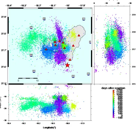
Fig. 2: Location oft the 8 OBS deployed offshore ElHierro.
OBS stations are shown with green symbols and are labelled with their numbers.
Red triangles indicate permanent landstations from IGN. Seismicity in the region of ElHierro Island between 01/06/2010 and 07/02/2015 (IGN catalogue) is shown with small circles. Depth of the events is shown for N-S cross- sections (top right panel) and E-W striking cross-section (bottom panel). The red star indicates the location of the submarine eruption in starting 10 October 2011.
3.) Participants 3.1.) Ship’s crew
1. GÜNTHER, Matthias Master
2. GRIESE, Theo Chief Officer
3. FRANKE, Remo 2nd Officer
4. FREUD, Hans-Jörg Chief Engineer
5. STEGMANN, Tim 2. Eng.
6. BAUMANN, Frank Electrician
7. ENGEL, Rüdiger Motorman
8. MISCHKER, Joachim Bosun
9. MEYER, Felix SM
10. KUHN, Ronald AB
11. MEILING, Ralf SM
12. RAUH, Bernd SM
13. BISCHECK, Olaf AB
14. MALCHOW, Klaus-Peter Cook
15. SCHMANDKE, Harald Steward
3.2 Scientific crew
1. Lange, Dietrich GEOMAR Chief Scientist
2. Krabbenhoeft, Anne GEOMAR OBS
3. Schneider von Deimling, Jens GEOMAR Multibeam 4. Rebaza Morillo,Anna Mireia Univ. de Barcelona Student
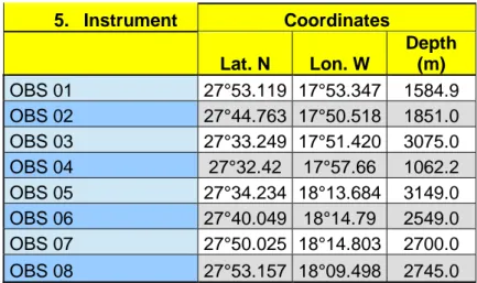
5. Instrument Coordinates
Lat. N Lon. W
Depth (m) OBS 01 27°53.119 17°53.347 1584.9 OBS 02 27°44.763 17°50.518 1851.0 OBS 03 27°33.249 17°51.420 3075.0
OBS 04 27°32.42 17°57.66 1062.2
OBS 05 27°34.234 18°13.684 3149.0 OBS 06 27°40.049 18°14.79 2549.0 OBS 07 27°50.025 18°14.803 2700.0 OBS 08 27°53.157 18°09.498 2745.0 Tab. 1: List of Ocean-Bottom-Seismometers (OBS) deployed during POS480. Location of stations is shown on the front page and in Fig. 2.
Fig. 3: Map of ElHierro showing the location of the 8 OBS stations (red circles). Blue circles:
permanent landstations from IGN; Blue circles: Landstations installed by GEOMAR in March 2016.
Acknowledgments
We are thank Master Mattes Günther, and crew of the RV Poseidon cruise POS480 for excellent sea-going support and a great working environment.