Towards Resilience
Adopting Local Knowledge in Rural Landscape Planning
A dissertation submitted to
The Department of Landscape Ecology and Landscape Planning School of Spatial Planning
TU Dortmund University
In fulfilment of the requirements for the academic degree of Doctor of Engineering (Dr. –Ing.)
BY Zhao Li
Supervised by:
Univ.-Prof. Dr. Dietwald Gruehn Univ.-Prof. Dr. habil Nguyen Xuan Thinh
Head of the Committee:
Prof. Dr. Stefan Greiving
i
Abstract
The frequency of extreme weather events increases as climate change. Rural settlements are affected by various natural hazards induced by climate abnormality. As a system, rural settlements have the capability to resist, response, and recover from the external changes. This capability is regarded as system resilience.
Enhancing rural system resilience is one orientation of rural planning work. One thorny problem in conducting rural planning is the lack of scientifically recorded data.
From the other side, rural residents boast local knowledge which has been inherited through generations.
This research collects local knowledge related to land management and disaster prevention, elucidates the preservation status of local knowledge, testifies the correctness of local knowledge, and analyses how local knowledge influences settlement system resilience.
Through literature research, fieldwork and on site survey, this research collected local knowledge and traced its evolution. The local residents in Chongqing rural region practice terraced rice field cultivation facilitated with a gravity irrigation system of Yantang. There are also Fengshui forests preserved from exploitation. The local knowledge about land management changes with time. Local knowledge about natural hazard prevention is compared with SWAT model simulation results and official records to testify the correctness. Since the accuracy of simulation is hindered by the insufficient data, local knowledge is superior to simulation results in the research region. The accuracy of local knowledge about the date when natural hazards happened is higher than that of the simulation result, so as the accuracy of the maximum water level during the previous floods. Local knowledge still contains the keen observation of the natural setting changes, and is applicable for predicting natural hazards and making contingency plans.
Instructed by local knowledge, settlements apply different land use strategies and result in the divergence of system resilience. Since local knowledge has evolved in different directions, settlement resilience change accordingly in good way or bad way. The dissemination of local knowledge mainly depends on the social network of neighbors, relatives and local governors. But because of the disintegration of such social relationships caused by village hollowing and urbanization, the dissemination of local knowledge is hampered. The possessors of local knowledge are easily affected by foreign and new information. As a result, in some extreme cases, local knowledge is gradually forgotten and replaced by modern science and knowledge. This research suggests that the rural planning towards resilience to learn from local knowledge through its trails and fails, and urge the development of local knowledge alongside with modern science and technology.
Key words: local knowledge; resilience; natural hazard
Declaration
I hereby declare that this doctoral dissertation, entitled “Towards resilience: Adopting local knowledge in rural landscape planning”, is the result of my independent investigation and it has been generated by me as the result of my own research. Where it is indebted to the work of others, acknowledgements have duly been made.
Zhao Li
21st. Sept. 2018
iii
Acknowledgements
I would first like to express my sincere gratitude to my supervisor Prof. Gruehn for offering me the opportunity to work on my Ph.D thesis under their supervision. He always encouraged me when I came across difficulties, and provided priceless advices for my research. I would also like to send my sincere appreciation to my second supervisor Prof. Thinh. His suggestions helped me to improve my dissertation a lot. I want to thank my colleagues, Bryce Lawrence, Jie Zhang, Yitu Yang for their continuous support and advices.
My deep appreciation goes out to Ms. Anne-Marie Geudens and Ms. Wildoer, for their kind guidance and assistance in all matters regarding the appointment arrangement, documents preparation and all the process of dissertation submission.
I would like to thank my colleagues in Greenpeace East Asia, who offer me a flexible and innovative working environment, so that I could complete my Ph.D research. My family and friends supported my unconditionally, so that I can strive towards my goal.
Finally, I appreciate the financial support from the China Scholarship Council (Grant No.201408080031) that
funded my research.
Table of Contents
List of Figures ... vii
List of Tables ... x
Chapter 1 INTRODUCTION TO THE STUDY ... 1
1 Introduction ... 1
Chapter 2 LITERATURE REVIEW ... 2
2 Theoretical Background ... 2
2.1 Settlement as a System ... 2
2.1.1 Urban System ... 2
2.1.2 Rural Settlement System ... 8
2.2 Urban and Rural Resilience Theory ... 10
2.2.1 Resilience ... 10
2.2.2 Disturbance ... 13
2.2.3 Evaluating Resilience ... 14
2.2.4 Evaluation Methods Derived from Other Dimensions ... 15
2.2.5 Three Components Contributing to System Resilience ... 16
2.3 Ethnography Theories ... 19
2.3.1 Local Knowledge ... 19
2.3.2 Evolutionary Epistemology ... 22
2.3.3 Precautionary Principle ... 23
2.3.4 Implications of local knowledge in rural planning... 24
2.4 The Potential of Applying Local Knowledge in Planning ... 26
2.4.1 Public Participation ... 26
2.4.2 Legal Environment of Public Participation in China ... 29
Chapter 3 RESEARCH DESIGN AND METHODOLOGY ... 30
3 Research Design ... 30
3.1 Research Question and Hypotheses ... 30
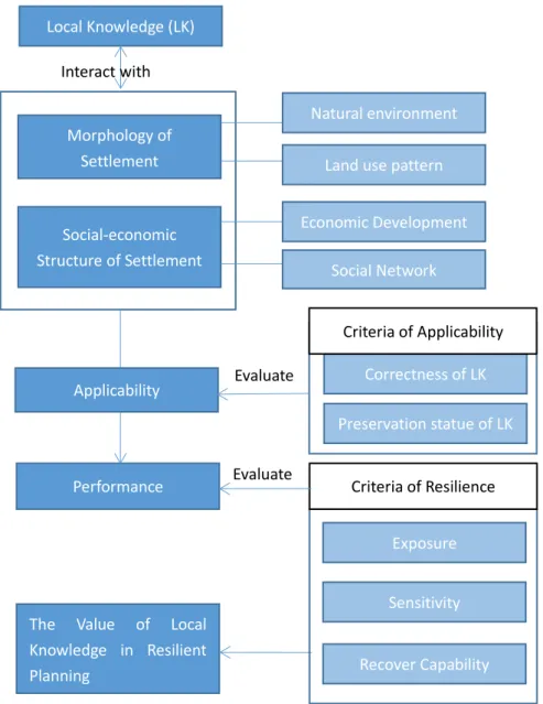
3.2 Research Structure ... 32
3.2.1 Investigation of the Contents of Local Knowledge ... 34
3.2.2 Evaluate the Correctness of Local Knowledge ... 35
3.2.3 Evaluate Local Knowledge’s Value in Improving System’s Resilience against Natural Hazards ………36
4 Research Methodology ... 36
4.1 Technical Methodology ... 36
v
4.1.1 GIS and Flood Simulation Models ... 36
4.1.2 Input Data Management for Hydrologic Models ... 41
4.2 Fieldwork Methodology ... 55
4.2.1 Questionnaire and Interview ... 55
4.2.2 Oral History ... 56
4.2.3 Mental Mapping ... 57
Chapter 4 INTRODUCTION OF THE RESEARCH REGION ... 58
5 Research Sites ... 58
5.1 Identification of the Settlement System ... 59
5.2 Environmental Setting of Sample Rural Systems ... 62
5.2.1 River Network ... 62
5.2.2 Landscape ... 64
5.2.3 Climate ... 65
5.3 Social-Economic Status ... 65
5.4 History and Cultural Background of the Inhabitants ... 67
Chapter 5 FINDINGS AND CONCLUSTIONS ... 71
6 Contents of Local Knowledge... 71
6.1 Productive Land Management Instructed by Local Knowledge ... 71
6.1.1 Agriculture from the Past to Present ... 71
6.1.2 Forestry from the Past to Present ... 89
6.1.3 Aquaculture ... 100
6.1.4 Other Livelihood Related Water Resource Management ... 100
6.2 Settlement Establishment Instructed by Local Knowledge ... 102
6.2.1 Principles for Site Selection ... 102
6.2.2 Morphology of Rural Settlement... 105
6.3 Local Knowledge about Natural Hazards ... 109
6.3.1 Prediction of Natural Hazards ... 109
6.3.2 Cultural Remains in the Naming of Settlements about Historical Disasters ... 112
6.3.3 Recorded River Water Level ... 113
6.3.4 Oral Narratives about Historical Disasters ... 114
7 Possessors of Local Knowledge and Local Knowledge’s Public Involvement ... 116
7.1 Possessors of Local Knowledge ... 116
7.2 Knowledge Dissemination and Public Involvement ... 121
7.2.1 Social Network: Local Governance in the Past ... 121
7.2.2 Prevailing Governmental Structure and Its Impact on Social Relations ... 122
7.2.3 Unauthorized Community Groups ... 125
7.2.4 Governmental Information Exchange System Regarding Natural Hazards... 126
7.2.5 Conclusion to Knowledge Dissemination among Local Residents ... 131
8 The Value of Local Knowledge in Planning towards Resilience ... 133
8.1 Correctness of the Local Knowledge about Disastrous Events ... 133
8.2 Local Knowledge Instructed Land Uses and Their Impact on Resilience... 152
8.3 Social-Economic Phenomenon Influencing the Preservation Status of Local Knowledge and System Resilience ... 170
8.3.1 Rural Hollowing and Its Impacts ... 170
8.3.2 Urbanization ... 174
Chapter 6 IMPLICATIONS ... 176
9 Discussion and Foresight ... 176
9.1 Discussion ... 176
9.1.1 Pre-requisitions for Local Knowledge Applied in Rural Planning ... 176
9.1.2 Local Knowledge in Development ... 178
9.1.3 The Acquisition of Local Knowledge and Modelling Input ... 179
9.2 Research deficiencies ... 181
9.3 Innovation points ... 181
Reference ... 183
Appendix I. Questionnaire ... 192
Appendix II Semi-Structured Interview Transcripts ... 199
Appendix III Oral History Transcripts ... 210
Appendix IV Mental Mapping ... 214
vii
List of Figures
Figure 2.1 Illustration of the threshold and range of one settlement ... 4
Figure 2.2 Market oriented system ... 4
Figure 2.3 Transportation oriented system Figure 2.4 Administration oriented system 5 Figure 2.5 Three phases of system’s response to disturbance ... 13
Figure 3.1 Overall research structure ... 32
Figure 3.2 Dissertation structure ... 33
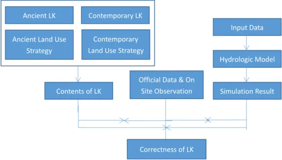
Figure 3.3 Research structure for testifying the correctness of local knowledge by comparison ... 33
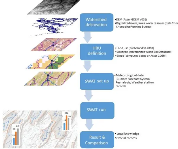
Figure 4.1 HRU/sub-basin command loop in SWAT model ... 38
Figure 4.2 The role of modelling in the research structure of testifying the correctness of local knowledge... 40
Figure 4.3 SWAT model workflow and expected result ... 40
Figure 4.4 Input data applied for SWAT model ... 41
Figure 4.5 The interface of SWCT module ... 46
Figure 4.6 Illustration of the unit plot in measuring USLE_K ... 47
Figure 4.8 Mental map drawing ... 58
Figure 5.1 The location of Chongqing municipality and research sites. ... 59
Figure 5.2 Geographical distribution of sample towns ... 62
Figure 5.3 Deep valley and cave formulated by limestone erosion in Jindao Valley Scenic Spot. ... 64
Figure 5.4 Annual precipitation in Chongqing from 1979 to 2015. ... 65
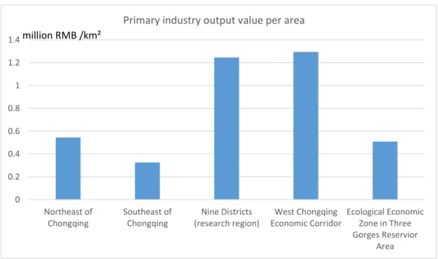
Figure 5.5 Primary industry output value per area in different economic zones... 66
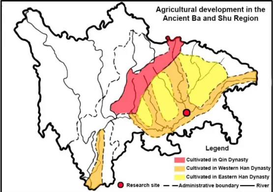
Figure 6.1 The farming tool of Musi. ... 72
Figure 6.2 The development of land cultivation in Ba and Shu Region. ... 73
Figure 6.3 The distribution of Shetian area in Ba and Shu Region in Tang Dynasty ... 74
Figure 6.4 Water Control Projects in Sichuan Province. ... 75
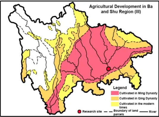
Figure 6.5 The third stage of agriculture development from Ming Dynasty to present. ... 77
Figure 6.6 Yantang located on top of a low hill (to the left of this photo) ... 80
Figure 6.7 The distribution of Yantangs and water courses ... 81
Figure 6.8 (left) & Figure 6.9(right) Modernized water control infrastructures. ... 82
Figure 6.10 Multi-crop cultivation in Yantang System ... 83
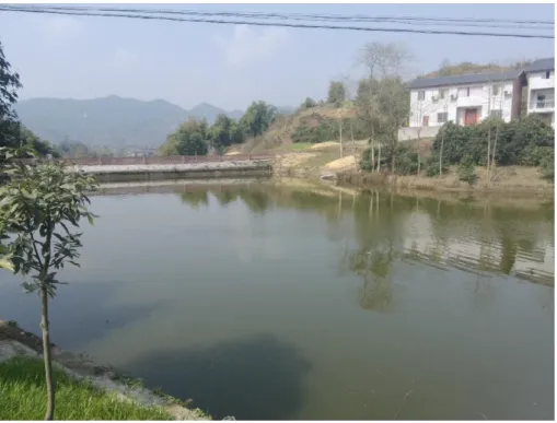
Figure 6.11 Previous Yantang now used as fish cultivation pool in Ma’an Village, Yubei District ... 84
Figure 6.12 Dryland farming in Germany ... 85
Figure 6.13 Typical dryland farming on slope and plain in Chongqing rural region ... 86
Figure 6.14 Soybean planted on dry farmland ... 86
Figure 6.15 Root of mustard (left) and root of oilseed rape (right) ... 87
Figure 6.16 Greenhouse vegetable planting in Taojia Town... 88
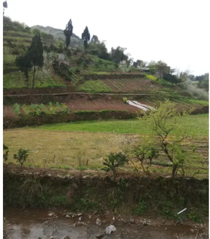
Figure 6.17 Wide terrace farmland used for dryland farming in Taojia Town ... 89
Figure 6.18 Illustration of the initial form of Shetian strategy ... 90
Figure 6.19 A Fengshui forest (left) in Liuyin Village ... 92
Figure 6.20 Warning of forest fire ... 94
Figure 6.21 Yantang for a conventional citrus orchard. ... 95
Figure 6.22 Experimental citrus planting base in Ma’an Village... 97
Figure 6.23 Citrus trees and soybean plants planted on steep slope along the highway ... 98
Figure 6.24 Landscape tree plantation in Ruyi Village, Jingguan Town ... 99
Figure 6.25 Dangdang in Tongxin Village ... 101
Figure 6.26 Video of a flood played in a local retailer’s store. ... 102
Figure 6.27 The location of the Old and New Jielong Town. ... 107
Figure 6.28 The composition of disaster response knowledge and training providers ... 109
Figure 6.29 Topics of knowledge about disaster prevention and mitigation the respondents are familiar with. ... 110
Figure 6.30 Local residents' perception about the major factors affecting the formation of flood and landslide ... 111
Figure 6.31 Cultural remains in rural settlements. ... 113
Figure 6.32 Interviewees in Chengjiang Town (left) and Maliu (Right) Neighborhood, showing the flood water level with abandoned houses. ... 114
Figure 7.1 Age composition of the respondents ... 117
Figure 7.2 Field of occupation distribution of the respondents ... 117
Figure 7.3 Annual income per household ... 118
Figure 7.4 Education level of the respondents ... 119
Figure 7.5 The number of administrative villages, ... 125
Figure 7.6 Precipitation monitoring stations in use in the research area. ... 127
Figure 7.7 Water level monitoring stations in use in the research area. ... 128
Figure 7.8 The site where the dissemination of local knowledge happens: Chang ... 132
Figure 8.1 Watershed delineation of Central Chongqing in ArcHydro. ... 134
Figure 8.2 Watershed delineation of tributaries by SWAT. ... 135
Figure 8.3 Land use type layer of Wubu River watershed. ... 136
Figure 8.4 Slope classification of Wubu River watershed. ... 137
Figure 8.5 Soil type layer of Wubu River watershed. ... 138
Figure 8.6 Simulations of water depth at No.4 sub-basin of Liangtan River. ... 141
Figure 8.7 Simulations of water depth at No.1 sub-basin of WuBu River. ... 142
Figure 8.8 Simulation result check of Wubu River with built-in program ... 145
Figure 8.9 Local people’s memory about historical disastrous events. ... 146
Figure 8.10 Extreme water depths compared with official flood event records. ... 148
Figure 8.11 Illustration of river flow direction and the backflow flood affected area in Tongjing Town. ... 149
Figure 8.12 Official water level mark on the bankside of Heishuitan River. ... 150
Figure 8.13 Comparison of water level information at SWAT monitoring points ... 151
Figure 8.14 Maps marked by the local people ... 153
Figure 8.15 The relationship between average slope and annual average flow velocity in channel ... 154
Figure 8.16 Adjacent area affected by different type of flood. ... 155
Figure 8.17 Distribution pattern of residential area (red squares). ... 158
Figure 8.18 Water line on a bridge across Daxi River in Taojia town center. ... 160
ix
Figure 8.19 Annual income per household in Yipin Town, Banan District... 167
Figure 8.20 Ratio of urban and rural residents in Chongqing from1996 to 2015 ... 170
Figure 8.21 Ratio of primary industry output in regional GDP from 1999 to 2015 ... 171
Figure 8.22 New job vacancies in urban economic units are constantly taken by more workforces holding rural Hukou. ... 172
Figure 9.1 Mental map for Tiaoshi Town and adjacent villages ... 214
Figure 9.2 Mental map around Chongqiao Village and Lijiawan ... 215
Figure 9.3 Mental map around Dongquan Town ... 215
Figure 9.4 Mental map around Pianyan Village and Xiangshui Village ... 216
Figure 9.5 Mental map around Pianyan Village and Xiangshui Village ... 217
Figure 9.6 Mental map to the west of Tongjing Town ... 218
Figure 9.7Mental map in Dongquan Scenic Spot Area ... 219
List of Tables
Table 4.1 The list of soil parameters required in SWAT model, data included in HWSD, and
preprocess methods ... 45
Table 4.2 Hydrologic soil group rating criteria in the US National Resource Conservation Service (NRCS). ... 47
Table 4.3 Slope classification for SWAT input ... 48
Table 4.4 Threshold level for multiple HRUs definition ... 49
Table 4.5 Sample of a virtual weather station ... 52
Table 4.6 The comparison between the two sets of precipitation data. ... 54
Table 5.1 Classification of rural settlement system in regard of production strategy ... 60
Table 5.2 List of towns for survey sample selection. ... 61
Table 6.1 Major agriculture types in the research region ... 79
Table 7.1 The Hierarchy of rainstorm risk. ... 128
Table 7.2 The Hierarchy of river flood risk. ... 129
Table 8.1 HRU report of Heishuitan River watershed ... 139
Table 8.2 HRU report of one of the sub-basin of Heishuitan River ... 139
Table 8.3 Google and Baidu search result about Chongqing rainstorm and flood events. ... 143
Table 8.4 Published official records of rainstorm, flood and landslide disasters in the research region. ... 143
Table 8.5 Factors of system sensitivity of different settlement types. ... 164
1
Chapter 1 INTRODUCTION TO THE STUDY 1 Introduction
Climate change and natural hazards have imposed major threats on urban and rural area around the world. The Intergovernmental Panel on Climate Change (IPCC) has reported climatic problems occurring across the world, including sea-level rise, increased intensity of droughts and floods, higher frequency of heat and cold waves, and melting glaciers in the first decade of the 21
stcentury (IPCC, 2014). Environmental changes are observed in three aspects:
water resource, food availability, and ecosystem. But it is also common that a small change of one meteorological factor imposes impact on all three aspects, due to the sophisticated consecutive effects in the environment.
Climate change causes a variety of sequential phenomenon in different regions. The precipitation increased in mid-latitude land areas of the Northern Hemisphere (IPCC, 2014).
There is abundant of evidence on a general decrease of agricultural productivity in certain regions, in accordance with precipitation changes (IPCC, 2012; People’s Daily, 2012; IPS, 2013).
The increasing frequency of extreme weather events also leads to the decline of agricultural yield. Thus climate changes not only impose geophysical deteriorates, but also foster a threat of living substance shortage. Smallholders, self-subsistence farmers and fishers who reside in rural regions suffer most from those complex and localized negative impacts. Their living environment can be regarded as a human settlement system, within which the system itself could adapt to the changes and maintain its normal functionality. When exceed the threshold, both the direct and indirect effects of climate change might cause a gradual failure of the entire system.
In history, people have always been interacting with the nature. People are observant to the environment in which they reside. Their knowledge suggests appropriate ways to utilize natural resources, and how to cope with climate abnormality induced natural hazards. As climatic problems aggravate in the recent years, urban and rural planning theories started to aim at improving human settlement’s adaptability to natural hazards. The fast development of modern technology supports new planning approaches. New approaches are based on multi-disciplinary information analysis. For the landscape planning aiming at mitigating and adapting to climate changes, observation data and statistics are the foundation for rational decisions. However, in developing countries or remote areas, the lack of scientific data has become a common situation. It still requires enormous monetary and human capacity investment to establish databases. Under this circumstance, can local knowledge supplement the insufficient data, so that better rural plans can be worked out?
In this research, human settlements, in particular small scale residential clusters, villages and
towns, are studied as settlement systems. Individual settlement system has intrinsic capability
to cope with external changes, including climate change, natural hazards, human conflicts,
and other crisis triggered by human activities. This intrinsic capability is generally studied as
system vulnerability, adaptability, or resilience. According to previous studies, many indicators decide system’s resilience. In rural regions, land use pattern, the economic status of a settlement, and disaster prevention strategies are still largely determined by local knowledge, aside from official governance. Those factors are identical with the indicators of system resilience. Therefore, local knowledge shows its influence on system resilience. To what extent, and in which way local knowledge would affect system resilience, is also to be explored in this research.
Chapter 2 LITERATURE REVIEW 2 Theoretical Background 2.1 Settlement as a System
A town or a village can be regarded as a system. An instinctive interpretation of human settlement system by anthropologists is the social interrelationships among individuals within a specific social group. By social group, they refer to villages, towns, cities, and their external relations with other social groups. Ecologist from a professional perspective generally chooses ecosystems as research subject, in order to confine the research from the spatial demarcation induced by social-economic factors. In the trend of multi-disciplinary study, provident landscape planning theories define their research subject in a more comprehensive way.
Settlement has its own “life”, as it was analogically interpreted by Christopher Chase-Dunn, advocator of world-system theory in 2005, by using the term “metabolism of settlement”.
This is not a new notion in the discipline of urban planning. The concept of urban metabolism can be traced back to the 1930s, when a city is perceived as a stable system for the first time.
As early as 1965, Abel Wolman (1965) established a quantitative model based on the concept of urban metabolism for the first time. He focused mainly on the circulation of clean water and sewage, considering the living environment deterioration of American cities in the 1960s.
The theories about urban system keep evolving and reforming for over 80 years. Many branch theories and hypothesis contributed to the prosperity of contemporary urban system study.
From the other side, a rural settlement can be regarded as a primitive form of a city, or a simplified version of a city. It is helpful to set up a rural system in order to have a rational understanding of some issues, for instance, how a rural community is operated, how the residents exploit and utilize natural resources, how a rural community reacts to negative environmental changes, etc.
2.1.1 Urban System
As the urban system has been thoroughly studied, the research about urban system provides
clue for the study on rural system, Before the WWII, Christaller (1933) and Lösch (1940)
published their Central Place theory, which is universally acknowledged as the origin of urban
3
geographers contributed to the improvement and refinement of the Central Place theory.
Their work marked the full establishment of urban system studies. In this primitive phase of urban study, urban hierarchy and the interactions between different urban settlements were predominant research directions (Coffey, 1998). Crisis raised, discussing whether the urban system study regard the city itself as the research object, or the integration of a city and its natural environment settings. Since the 1970s, technology and methodology of urban research significantly improved. Studies on specific issues, to solve the various specific problems in the city, sprung up. Urban metabolism and urban ecology fast developed, as increasing conflicts between human and nature were brought by industrialization. In energy and material flow study, entropy models were popularized after the publishing of “Entropy in Urban and Regional Modeling” (Wilson, 1974). The entropy concept is therefore attached with various interpretations in different field of studies. In the 21
stcentury, bottom-up approaches are adopted in urban study. The connotation of bottom-up analysis contributes to the study of urban growth. One of the most frequently applied methods is the discrete model of cellular automaton, built on the Geographic Information System (GIS), and supported by GIS extension programs. To date, urban systems study covers too wide a spectrum that confusions might occur when clarifying the boundaries of each branch of study.
2.1.1.1 Central Place theory
Central Place theory is about the principles of human settlement hierarchy. It explains how the hierarchy of different settlement units (centers) is formulated, while each settlement unit is provided with similar primitive settings. To simplify the setting, factors such as topography, history and climate were excluded from the simulation. Focus was put on the variables in three dimensions, namely the marketing, transportation and administration. Central Place theory shows the impacts of economy, infrastructure, and policy on the pattern of settlement hierarchy, rather than the exact geographical distribution of rural settlements. While the economic status, political environment and infrastructure of a settlement reflect mainstream local knowledge.
Central Place theory was developed based on a series of assumptions. A settlement, or a
center, is a functional unit. In this model, settlements evenly distribute on a homogeneous
imaginary surface. All settlements are equidistant in a triangular lattice pattern. Population
and resources are also evenly distributed. To simplify the transportation factor, the model
applies distance decay mechanism. Each center has a threshold, within which the settlement
is able to provide goods and service for itself. The range indicates the distance consumers are
willing to travel, as they purchase goods and services from other centers (Fig. 2.1). The
distance cost is directly proportional to the distance between the threshold and range. In
general, distance cost exceeds the demand for goods outside the range. In the model, all
sellers are in perfect competition, and pursue maximum profit. Consumers share identical
purchase behavior and demand for products.
Figure 2.1 Illustration of the threshold and range of one settlement
According to the assumption, the configuration of settlement, including population, resource, productivity, threshold and range and so on, is represented by geometric features. That is to say, the default settings confine variables to geometric features, so that geometric algorithm can be applied for modeling. Given a minor variation in resource distribution at the beginning of modelling, the stable state of the system would soon be disrupted accordingly. Modelling results in a system of settlements of different sizes, or at different level of hierarchy.
Christaller (1933) deduced three patterns of settlement systems, subject to marketing, transportation and administrative principles, respectively. K-value represents the number of settlements influenced by a consecutive higher-order settlement.
The marketing principle influenced system (K=3) resembles the market-centered rural region (Fig. 2.2). Each marketing center serves two consecutive lower hierarchy settlement and the one itself. In this system, the travelling distance is minimized, but travel efficiency is not the optimal, as there is no direct routine between marketing centers of higher level of hierarchy.
Marketing principle shall be applied in the regions, where the market determines system development.
The transportation principle (K=4) ensures the configuration of a most efficient transport network (Fig. 2.3). Each marketing center comprises a half of the marketing area of six
Threshold Range
Settlement
Figure 2.2 Market oriented system
Reference: http://cronodon.com/images/CentralPlace5.jpg
5
locates in the center of the system, is directly connected with consecutive lower-order settlements. This pattern resembles the situation in newly-founded development areas and transit oriented development region. In the densely populated industrial regions, the principle of transportation overweighs that of marketing.
Figure 2.3 Transportation oriented system Figure 2.4 Administration oriented system
Reference: http://cronodon.com/images/CentralPlace6.jpg Reference: http://cronodon.com/images/CentralPlace7.jpgThe central marketing center completely encloses seven lower-order settlement according to the administrative principle (K=7) (Fig. 2.4). This principle is applicable in the regions where administrative power denies its subordinate settlements to be “shared” with other systems.
Similar situation also exists in the remote regions where the entire system is isolated from other urban systems.
These three principles lead to the configuration of urban hierarchy. Christaller leveled the hierarchy based on the number of subordinate settlements which belong to one higher-order settlement. The five levels are metropolis, city, town, village and hamlet, respectively.
Central Place theory illustrates the patterns of settlement hierarchy. Given simplified assumptions, it deduced how the principles of marketing, transportation and administration shape the settlement system. Though Central Place theory is based on the data drawn from field research in the Southern Germany, the model is still criticized to be static and unrealistic, as the assumptions deviate from actual situation (Veneris, 1984; Openshaw, Veneris, 2003).
Central Place theory is conceived to be better applicable in agricultural areas instead of industrial or post-industrial areas. The three principles are helpful to understand the configuration of agriculture dependent settlements, say, villages and towns. It helps to reveal the relationship among villages and towns, and hence the dissemination pattern of local knowledge within certain rural region.
2.1.1.2 Dynamic central place theory
Scholars elaborated the Central Place theory in the following 30 years. Focus was still on the
interactions between rural settlements or cities, rather than the interactions between the
human settlement and the nature. In the 1970s, scholars proposed a dynamic central place
theory (White, 1974; Allen, Sanglier, 1979), as a refinement of the original “static” one. In this
theory, they shifted their focus from the abstracted geometric features of central places, to the dynamic growth patterns of each settlement in the system. The research object of dynamic central place theory is the behavior of each settlement during the formation of settlement system.
In the dynamic central place theory, a paradigm of growth is assigned to individual settlement.
The size of a “center place” could be calculated, with the input parameters of growth, revenue and cost functions (White, 1977). White’s simulation model is driven by the difference in the profit of each settlement. The location of settlement is fixed, but the initial sizes of the settlements are not necessarily identical. Revenue is calculated based on a gravity equation, or an exponential equation. In these two interaction equations, a range of parameter N (the distance exponent) values are input to calculation. Parameter N is in positive correlation with distance. The transition zone of high and low value N is analyzed considering the initial settings of center distribution and interaction equation. Simulation result presents the state of settlement system, when it reaches an equilibrium position.
The interaction equation is the core of this model. Parameter N largely determinates simulation results. Results show, that in both interaction equations, given high components of N, the size of a settlement is decided by the distance between the settlement and its neighbors; given low N exponent, the major determinant of settlement size is the distance between the settlement and the geometric center of the entire region. When the influence of economic factors is considered, some remote settlements will eventually disintegrate. For high exponents value N, settlements tend to evenly distribute in a region, and end up in similar size (multi-center pattern), while for low exponents of N, few large settlements locate in the middle of a region (mono-center pattern). To some extent, calculation result indicates that the pattern of settlement system is determined mainly by the initial extent of discretion of the settlement, and the scale of the system. The introduction of Parameter N and the transition zone, contribute to a new interpretation about the definition for a settlement system. In the case of high value N, the multi-center region could be perceived as an aggregation of several mono-center systems with low value N. Thus individual mono-center system could be perceived as the basic unit of settlement system. This assumption is yet to be tested.
Dynamic central place theory illustrates how centers grow or demolish, given more plausible
assumptions in market and transportation principles. It starts with a set of chaotically
arranged settlements, and ends in an equilibrium state. It should be noted, that the limitation
of productivity and resources were not considered as a parameter, throughout the evolution
of central place theory (Allen, Sanglier, 1979). Dynamic central place theory provides a new
perspective to analyze the growth or recession of settlements in the research region. To some
extent, it resembles a process, during which the randomly emerged settlements are screened
out, and only the ones with advantaged geographical location, preferable transportation
accessibility remained, while the appropriate location and good transportation represent
well-applied local knowledge.
7
2.1.1.3 Urban metabolism
In another branch of urban study, the focus shifts from the hierarchy (system) of settlements to an individual settlement (urban system). Urban metabolism is based on the assumption, that a city has its own energy flow and material flow, resembling a biological organism. Urban metabolism emphasizes the interrelationship between the society and nature, in order to study the material and energy flow of an individual city. In the 21
stcentury, urban metabolism was given the definition of “the sum total of the technical and social-economic processes that occur in cities, resulting in growth, production of energy, and elimination of waste” (Kennedy et al, 2007).
The origin of urban metabolism dates back to the Marx’s sociology (1867). In his theory, metabolism is driven by capital flows, and reflected in the transformation of the nature as well as the human society. Through physical labor, human beings acquire living substances, and at the same time change the biophysical conditions of the nature, which in return affects human livelihood. As Foster (2000) stated, metabolism is the foundational concept underpinning Marx’s interpretation of human-nature relationship as the mutual interaction through human activity.
The concept of urban metabolism then evolved into two branch subjects, the material flow analysis inspecting the material and energy flux (Barles, 2009); and the Emergy method which sees the metabolic flows by measuring the solar energy involved in the system (Odum, 1983).
Abel Wolman (1965) tested the fundamentals of urban metabolism of the material flow in a quantitative approach. He calculated the inputs and outputs of material of a hypothetical American city with the population of one million. In his experiment, emphasis was put on the capacity of the nature to supply an expanding city. While Odum’s Emergy method is more ecology biased, and difficult to integrate socio-economical parameters and biophysical parameters (Alberti, 1999), the approach of energy-material flux became the mainstream of urban metabolism, as it is more comprehensive and easier to practice by urban researchers.
One essential concept in urban metabolism research is the threshold, or carrying capacity of the natural environment, conventionally used to evaluate system sustainability. Since the theory of urban metabolism fast evolved in the context of industrialization, sustainability became the top priority of all issues in the discipline of urban planning. Models of urban metabolism were widely utilized to examine the energy and material budget, or in other words, the “sustainability” within an existing urban system or neighborhood (Kennedy, 2010).
The energy-material flux can be clearly illustrated through modelling, so that urban planners are able to make corresponding adjustments, in order to stop a city system from exceeding the carrying capacity of the environment. Considering the specific conditions of particular urban systems, the model should additionally include the factors which are likely to impose significant influence, for instance, the population living in urban villages.
Contemporarily, the inner fluctuations and their effects on an urban system are studied in
urban researches, as well as the inter-relationship between the external environment and the
urban system. For the study about nature-urban relation, there are still unsolved problems in
data integration and uncertainties in defining the scale of analysis (Pincetl et al., 2012). For
more sophisticated natural processes, interdisciplinary cooperation is still required, in order
to improve the urban metabolism framework.
To conclude, urban metabolism is a study concentrating on the mutual interaction between an individual city and its surrounding natural environment. A city or community is compared to a biophysical organism, which consume, transform, and release matter and energy. Models are established to investigate the energy and material flux of the urban system. Modeling results reveal whether a system is sustainable or not. This research perceives the human settlement and its natural environment together as a rural settlement system. The study of urban metabolism helps people to understand the interaction between an individual human settlement and the natural environment. Specifically, this research puts emphasis on the recovery of a settlement from physical destruction. Urban metabolism sheds light upon the energy flow and material flow during the process of reconstruction.
2.1.2 Rural Settlement System
The literal meaning of a rural area is the geographical region outside cities. However, it provides little specific characteristics of rural area its own. Another credible but perception-based definition, is even obscurer. Rural settlement is where most residents think of as it is (Thorburn, 1971). Researches based on this kind of definition reveal essential components of rural area by investigating people’s mental cognition. According to those studies, rural region in the common sense is a place with the following features: lower population density; inconvenience transportation to modern cities; relies heavily on agriculture and attaches its specific emotional influence to people (Palmer et al., 1977).
Though Palmer’s investigation was launched decades ago, the conventional cognition of rural changed little. This cognition of a rural region is identical in China. In Chinese language, rural region writes “
农村”, the first Chinese character indicates agriculture, and the second means the human settlement with wooden buildings. The conjunction noun
农村, refers to the human settlements and the agricultural land they attach to. Even in the modern times villages and towns resemble cities in many aspects, the understanding of rural settlements does not change much.
Reviewing urban system studies, three major categories can be divided based on the research subjective. The majority of urban system studies confine on the city itself, separated from natural environment. They focus on a single, or a limited number of factors affecting the operation of an urban system. A second category of urban study regards urban system as an individual human settlement together with its subordinate (or supporting) environment. The third, with the representative of the central place theory, focuses on a larger-scale system consisted of numerous human settlements. Compared with cities, rural settlements, including informal household clusters, villages, and un-urbanized towns have less complexity in social, economic and cultural structure.
Villages are admittedly more dependent on the natural environment. The nature provides
inhabitants living substances. The changes in natural environment undoubtedly affect the
functionality of the system. The prevailing economy pattern of single agricultural product
economy in villages and towns makes the system hard to recover from disastrous events,
9
the critical feature of a rural settlement system. From another point of view, this feature of rural system induces lurking perils.
Each town can be regarded as a developing, juvenile city, thus analog could be easier made to urban metabolism. The system functions as a precise organism within a dynamic equilibrium:
the circulation of energy and material, and the counterbalance of economic profit and political power. A town assimilates goods and services from the nature and its adhering villages, transforms or stores them, generates waste discharge and releases the wastes back to the nature. The feature which distinguishes a relatively independent town center and other rural settlement systems is the extent of dependence on natural resources. In some town centers, a considerable proportion of the inhabitants has long been alienated to agricultural work, and given up their land use right. This indicates that the town centers are in an intermediate state between the pure agriculture dependent rural settlement, and the commodity supplied city.
Except from the dependence on material resources, rural inhabitants also have a psychological attachment to nature. People’s respect for specific mountains, rivers, plant and animal species is still unintentionally revealed in their daily life and in the communication with foreigners. Due to the close relationship between local people’s livelihood and nature, this research mainly adopts the research scope of the second category of urban system study, and perceives the organic aggregation of rural settlement and its adhering natural environment as a rural settlement system.
The Central Place theory and its expansion, the dynamic central place theory, provide theoretical bases to the distribution pattern of the settlements, as well as the hierarchy of settlements in rural region. There are evidences of existing settlement patterns subjected to the three principles of transportation, market, and administration. For instance, the market principle in Central Place theory is convinced by the villages located within one-hour walking distance of the rural markets around 500 years ago. The transportation principle explains the fact that the settlements located alongside highways stand have the longest history, and always larger in size than other settlements away from main roads.
The dynamic central place theory, on the other hand, sheds light upon the question, why villages and towns decay. In the model, centers decay because of negative revenue in the equations of population, distance/accessibility and cost. However, none of the existing models take the constantly changing productivity and people’s livelihood in consideration.
While in reality, this factor has become rather decisive for the growth or decay of a settlement. The agriculture bund productive activities and economic structure would change.
In some cases the farmland resources no longer restrict population distribution, especially for the working population in the rural area. The market centers within the rural region still attract population and goods, but their attraction is incompatible with the fortune and working opportunities provided by centers outside the rural region, say, the cities and metropolitan. The social phenomenon that villages and towns lost their residents, is generally referred by scholars as “rural hollowing”, and will be introduced in a separate section (8.3.1).
In the research region of Chongqing rural area, the reign authority does not always fall in
accordance with the effective organization structure. A settlement system is not necessarily
confined to the administrative boundary of the settlement. Confusions on the effective authorities are frequently inspected in the places where administrative boundaries have been adjusted. In some cases, the local inhabitants still cling to the executively abolished administration structure, instead of the newly organized ones. For those specific settlements, the authority structure is considered in defining the boundary. In this research, the focus lies on the capability of a system to cope with natural hazards. Land use category, land management strategy, and the environmental settings are the characteristics of a system, as well as the decisive indicators of system resilience. It is easier comprehensible, if the basic unit of rural settlement system could be characterized by such limited number of major features. This basic unit can be an organized production team in a village, with the farmland, forest, natural creek and residential area under its jurisdiction. A basic unit shall be distinguished from adjacent units by the differences in the major determinative factors mentioned above.
Regarded as an organism, a settlement system not only deals with the fluctuations within, but also the external stresses outside. Especially for the micro-scale system, in which the relationship between human and nature is the closest, how would such system response to external changes, would the system survive through?
2.2 Urban and Rural Resilience Theory
2.2.1 Resilience
Increasing frequency of droughts and floods, heat and cold waves is taking place in urban and rural regions alike. The abnormal precipitation intensity leads to reduction of agricultural productivity in most of the affected rural regions (IPCC, 2012). Droughts and floods resulted from unevenly distributed precipitation would further impose life threat and economic losses.
Urbanization also imposes significant influence on rural settlement systems. Rapid growing economy and ambitious development policy in China urges rural settlements to urbanize, whether prerequisites have been fulfilled or not. In many rural settlements, working force leaves their homes to seek for fortune and a new way of life in a city. It has become the most common phenomenon, in which villages are left only with young children and grandparents.
As consequences, social-economic structure is destroyed, leading to an irreversible deterioration in a rural settlement system (Chan, 2010). This makes an example of external economy and policy change.
As external changes occur at an increasingly higher frequency, a large number of researches
are launched, to explore settlements’ responses towards equilibrium-threatening
disturbances. Settlements’ response to external disturbance can be divided in three major
categories, based on the severity of consequences. In the first type of response, forces and
pressures brought by disturbance are absorbed by the system. The system functions just the
same as before, no significant impact is imposed. For instance, increased precipitation
intensity results in a higher level of water level, while the river bank successfully holds the
flood. This type of response can be found in most of the successful disaster prevention
11
projects. In the second category, external disturbances impede normal functionality in a settlement system to some extent, but the system is able to recover to its previous state, or even better, to an optimized new state. This indicates that there is the possibility, that a disaster affected settlement system survives the negative consequences. There is a specific type of planning, the post-disaster planning, aiming at helping a settlement to recover from both direct and indirect damages caused by disasters. As worse come to worst in the third category of response, in which disturbance leads to a sudden or gradual dysfunction of the system, making it impractical to recover. For instance, in a severe landslide disaster, the settlement was buried by debris and it beyond the ability to rebuild. Local residents therefore have to resettle themselves.
Those three categories of responses correspond to Thomé Schmidt’s classification of society’s response to natural hazards, namely resistance, resilience, and retreat (Schmidt et al., 2008).
This classification is based on the efficiency of actions or measures against disasters.
Considering the dynamic within the system and the practical significance, it is reasonable to put emphasis on resilience.
The concept resilience originates from the subject of psychology in the 1940s, in a study of patients’ competence when facing danger. As a paper about Project Competence (Garmezy, 1973) published in 1973, the word resilience was first introduced into academic world. In the same year, another predominant interpretation of resilience in the discipline ecology emerged. Ecologist Holling (1973) defined resilience as “the capacity of an ecosystem to tolerate disturbance without collapsing into a qualitatively different state”. The notion of resilience further influenced disciplines such as climatology, business and policy making, and became a key word in various research fields. For instance, resilience is perceived as a synonym of recover and resistance in engineering study (Folke, 2006). Climate resiliency has also been integrated in urban development studies (McEvoy, 2019). The most acknowledged and accepted definition is from the IPCC SREX report (2012). Resilience is the ability of a system to anticipate, absorb, accommodate, or recover from the effects of a hazardous event in a timely and efficient manner. Accompanied by the widespread of this notion, misinterpretations emerge, especially when translated and introduced in none English context. In the past decade, resilience planning was frequently confused with flexible planning (Yin, 2006), since in Chinese language those two phrases are translated exactly the same.
According to Walker and Salt (2006), the conceptual idea of resilience has long penetrated in
urban and rural planning. It was not until the 21
stcentury, when resilience planning was
studied as an independent branch of planning study. By the same time, the study of rural
resilience emerges as in analogy to urban resilience (Heijman et al, 2007). With other scholars,
Holling then expanded their research range with human related factors. Research objectives
shifted from ecosystem to socio-ecological systems (SESs). They synthesized three
fundamental characteristics of SESs, resilience, adaptability and transformability, respectively
(Walker et al., 2004). The term resilience was redefined in spatial planning context as “the
capacity of a system to absorb disturbance and reorganize while undergoing change, so as to
still remain essentially the same function, structure, identity, and feedbacks” (Walker et al.,
2004). Another definition given by Renschler et al. (2010) interpreted resilience as a “function
indicating the capability to sustain a level of functionality, or performance…over a period defined as the control time”. This definition provides landscape planners with an operational inspiration instead of conceptual understandings.
Just as contemporary landscape planning study involves multi-disciplinary framework, major viewpoints of resilient planning falls in the following five realms. Ecological Resilience is one of the branches with the longest history, with Holling, Gunderson and Alberti (1999) as representatives. This school of thought works at establishing “adaptive cycle” simulations of ecosystems, for instance the Panarchy (Grunderson, Holling, 2002). Alberti developed an urban-ecological model (UEM) to predict changes of human induced stress on urban ecosystem. Technical Resilience proposed by Wildavsky (1988), Bruneau et al. (2003) and the research institution MCEER (2005), emphasizes on the rigidness and the speed of returning to equilibrium after disasters. According to Adger (2000) and Paton, Johnston (2001), Social Resilience indicates the process of community to learn from and resist disasters or stress. It is especially important for indigenous communities experiencing the overwhelming trend of modernization and globalization. Similarly, Economic Resilience (Rose, Lim 2002; Polèse, 2010) enables a city or community to reduce economical loss during and after hazards. Another realm mentioned in the MCEER (2005) is Organizational Resilience, indicating the capacity of organizations to manage major disasters, via public communication and decision making, etc.
Interpretations of resistance and resilience from several influential scholars in their own perspectives have been presented above. Distinctions are obvious. Yet it is still confusing:
which roles resistance, resilience and recover play in a disturbed system?
As it is elaborated in Walker’s theory, two processes run simultaneously in a system undergoing disturbances. One process “absorbs” disturbance, and the other attempts to recover from damages and disorders. By absorbing disturbance, material components of the system initially resist the change, when reaches a certain threshold, they adjust to the new situation, without imposing irreversible destruction on the system.
Three chronical phases are identified in the dynamic of a resilient responding towards
disturbance (Fig. 2.5). The first phase, pre-disturbance, is the stable state of system before
the system gets struck by a disturbance. The second phase, system reacts to the disturbance
by resisting and responding actively to external forces/pressures, and recovering from
damages. In the post-disturbance phase, system returns to a stable state, though not
necessarily the exact same state before disturbance (Renschler et al., 2010). Post-disturbance
phase can also be regarded as pre-disturbance of the next recursion. The chronical sequence
of a resilient response is in the pattern of an ascending spiral. Resilience constantly exists
until it sees the demolition of the system.
13
Figure 2.5 Three phases of system’s response to disturbance
Regarding to resilience enhancing in urban planning, an institutional dimension is studied by researchers. In many cases, the term of resilience is not explicitly referred, but “adaptation”
and “sustainability” are applied instead. For instance, the governmental climate change adaptation strategies are evaluated (Lee, 2018), the stakeholders in relation to resource management are identified and their demands analyzed (Friend, 2018). These researches reveal the challenges and their influence in the near future, implying that they can support the branch of urban resilience.
A few studies applied resilient thinking strategically in actual planning practices (Baird et al., 2016). To practice resilience planning, practitioners develop a social-ecological system perspective, and clarify the goals of resource and risk management. Since the practices of resilience planning is normally focused on local or regional scale, and catering to specific issues of the research sites, very little synthesis have been achieved across the case studies (Sellberg et al., 2018). Without a general applicable framework for all research sites, each practice may lead to a new approach.
To conclude, resilience in this research is the intrinsic capability of a settlement system to sustain a stable state against external disturbances. Resistance and the ability to recover are impartible components of resilience, predominating in pre-disturbance, disturbance, and post-disturbance phases. A low-resilience system tends to deteriorate by ceaseless crushes of disturbance.
2.2.2 Disturbance
Not all disturbances lead to disasters. The severity and the frequency of occurrence of disturbance itself, and the resilience of system together determine the consequences of disturbance.
External disturbances come from all aspects in the world. The changes in the general condition of regional economy, land use policy, and even in the speed of economic growth of adjacent region, all impose certain influence on a settlement system. This research confines the focus mainly on extreme environmental changes, to be more specifically, natural hazards.
Disturbance
Post- Disturbance Pre-
Disturbance
Considering the geographic and climatic conditions of the research area, this research concentrates on flood and landslide, as they are the major type of natural hazards in the region. Social economic changes are taken into consideration, where the content and transmission of local knowledge are influenced. They are also analyzed when assessing system’s capability of recover.
In the research region, the fundamental triggering factor of flood and landslide is excessive precipitation, while not all excessive precipitation causes those natural hazards. The land use condition of a rural system could either impel or prevent such natural hazards from happening. For instance, the mountainous region covered by forest is less likely to flood, but given a land parcel without vegetation cover, the possibility of flood and landslide would significantly increase. In this case, land resource management determines the resilience of a settlement system. Viewing from the perspective of the settlement system, it is also obvious that the geographic location of settlement itself largely decides the risk of natural hazards.
For many other reasons, such as the financial state of the household, local residents may not move and settle in other places to avoid the risk. Under this circumstance, the system is exposed to potential natural hazards. As the residents unable to bestow monetary in reviving the settlement system, the settlement system can be considered as sensitive to the negative impact of natural hazards.
What is the likelihood that a settlement would be affected by natural hazards, and how severe the outcome would be, requires further assessment on the resilience of the settlement system.
2.2.3 Evaluating Resilience
It has been a conundrum since the generation of resilience concept, to measure a system’s resilience in practice. The Organization for Economic Co-operation and Development (OECD) developed a framework on resilient cities and launched projects in 10 cities as provided by the official website
1. Resilience is measured in four areas: economy, society, governance, and environment. The statistics of 19 indicators are applied in the measuring. In the referential approach of PEOPLES Framework (Renschler et al., 2010), 7 components and nearly 100 sub-components presented all major characteristics of a community scale system, regarding to resilience. Sub-components, especially in several indicators of social-economic developments remain obscure and difficult to evaluate, for instance, cultural and heritage services, and place attachment. Other components, for example public participation, poverty, food supply, and water quality/quantity requires specialized evaluation work. What makes the task even laborious to accomplish, is to synthesis all components and to calculate resilience index. Since functionalities of components overlap or mutually influence each other, a proper mathematical function is required, taking all the interactions among components and weights of different components into account. Unfortunately in most of practical projects, neither time nor working force is abundant enough to fulfill such a sophisticated framework.
PEOLPLES framework provides instructions on how to evaluate system resilience based on its
original functionality, yet in practice, quantitative measurements of resilience are seldom
15