• Keine Ergebnisse gefunden

How is the age of an anthropogenic habitat - calcareous grasslands - affecting the occurrence of plant species and vegetation composition - a historical, vegetation

N/A
N/A
Protected

Academic year: 2021

Aktie "How is the age of an anthropogenic habitat - calcareous grasslands - affecting the occurrence of plant species and vegetation composition - a historical, vegetation "

Copied!
122
0
0

Wird geladen.... (Jetzt Volltext ansehen)

Volltext

(1)

How is the age of an anthropogenic habitat - calcareous grasslands - affecting the occurrence of plant species and vegetation composition - a historical, vegetation

and habitat ecological analysis

Welche Bedeutung hat das Alter eines anthropogenen Lebensraums, der Kalkmagerrasen, für das Vorkommen von Pflanzenarten und die Zusammensetzung der Vegetation

- eine kulturhistorische, vegetations- und standortökologische Analyse.

D ISSERTATION ZUR E RLANGUNG DES D OKTORGRADES DER

N ATURWISSENSCHAFTEN (D R . R ER . N AT .)

DER F AKULTÄT FÜR B IOLOGIE UND V ORKLINISCHE M EDIZIN DER U NIVERSITÄT R EGENSBURG

VORGELEGT VON

Petr Karlík

aus Prag

im Jahr 2018

(2)

2

Promotionsgesuch eingereicht am: 13.12.2018

Die Arbeit wurde angeleitet von: Prof. Dr. Peter Poschlod

Prüfungsausschuss: Vorsitzender: Prof. Dr. Christoph Reisch

Erstgutachter: Prof. Dr. Peter Poschlod

Zweitgutachter: Prof. Dr. Karel Prach

Drittprüfer: PD Dr. Jan Oettler

(3)

3

Contents

Chapter 1 General introduction 5

Chapter 2 History or abiotic filter: which is more important in determining the species

composition of calcareous grasslands? 13

Chapter 3 Identifying plant and environmental indicators of ancient and recent calcareous

grasslands 31

Chapter 4 Soil seed bank composition reveals the land-use history of calcareous grasslands. 59 Chapter 5 Soil seed banks and aboveground vegetation of a dry grassland in the Bohemian

Karst 87

Chapter 6 Perspectives of using knowledge about the history of grasslands in the nature

conservation and restoration practice 97

Summary 104

Literature 107

Danksagung 122

(4)

4

(5)

5

Chapter 1

General introduction

Dry grasslands – an extraordinary habitat

When we evaluate natural habitats, we often ask why they are valuable from a conservation point of view. Oftentimes we evaluate their species diversity. For individual species, we consider whether they are original or not. This, of course, raises the question of exactly what the word "original" means.

If we are looking for an answer to the issue of originality, we need to look at how old a habitat is.

If we ask this question in Central Europe, we find a fascinating biotope - dry grasslands. For several thousand years, they were necessary for humans as a place of grazing livestock. On the vast majority of their size, grasslands are conditioned by man, without whose activity they would disappear. Yet the grasslands may be extremely old because they follow on, in general, the old- holocene vegetation. So, they may be a more ancient biotope than common forests with beech and fir. Furhtermore, dry grasslands are exceptionally species-rich.

The present dissertation is a modest contribution to understand this fascinating biotope and asks questions related to how different historical factors affect the state of the current vegetation.

History of dry grasslands and species diversity

Dry calcareous grasslands may strongly differ in their floristic composition, which may depend not only on present day habitat quality and management, either by grazing or by mowing, but also on their age (Gradmann 1933). Relict grasslands may exist in direct continuity with post glacial cold continental steppes but have been maintained by humans since the beginning of settlement (Gradmann 1933, Pokorný 2005, Ložek 2007, Pokorný et al. 2015). In contrast, semi-natural grasslands, which are the object of the present dissertation, developped mainly as a consequence of forest grazing as secondary vegetation. These grasslands have provably existed since the Neolithic Age (Kaligarič et al. 2006, Dutoit et al. 2009, Poschlod & Baumann 2010, Hájková et al. 2011, Hájek et al. 2016, Robin et al. 2018).

Species, which later constituted species pool of the semi-natural grasslands may have survived either in open forests (Roleček et al. 2014, Hájek et al. 2016) or in microrefugia such as small patches on rocky outcrops (Bylebyl et al. 2008, Ložek 2011, Tausch et al. 2017). Based on extensive review, Kajtoch et al. (2016) are showing that distinctiveness of many dry grassland species populations suggests a survival in the Central Europe during glacial maxima. Surviving of heliophilous species throughout the Holocene was surely supported due to grazing by wild animals (Vera 2000). Many species, however, have probably only immigrated into Central Europe with the first settlers and their livestock (Poschlod 2015b, Meindl et al. 2016, Leipold et al. 2017).

Representation of relict species of primary grasslands increases with the continentality level

of particular region. A typical example of a significantly continental territory in Central Europe is the

Böhmisches Mittelgebirge in north-west Bohemia, the Saale-Unstrut Region in central Germany, the

banks of the river Oder and Pannonikum (Ellenberg 2010). To the subcontinental regions can be

(6)

6

included Franconian Alb near Regensburg (Poschlod et al. 2016) or Bohemian Karst in central Bohemia (Ložek et al. 2005, Ložek 2007). Present dissertation deals with the two last regions.

Loss of area, nature conservation and management

Dry calcareous grasslands are, due to their high species diversity and the occurrence of many relic species, regarded as one of the most important habitats in Europe from a conservation point of view (e.g. Korneck et al. 1998, Wallis de Vries et al. 2002, Sádlo et al. 2007). They are in the focus of conservation efforts and are listed in the Annex I of the Natura 2000 Habitats Directive (92/43/EEC).

To understand the threat of dry calcareous grasslands, it is necessary to know the historical dynamics of their area. Dry grassland extended their area in connection with the landscape colonization by man. Important periods of extension were Bronze Age and especially the High Medieval Ages and then the 18th and 19th century of Modern Times (Baumann 2006, Poschlod &

Baumann 2010). Because of low productivity and fundamental changes in agriculture came since the end of the 19th century to continual decrease of area (Quinger et al. 1994) with the strongest decline during the 1960s and 1970s (Mattern et al. 1992, Mauk 2005). Fundamental cause was increased imports of sheep wool from e.g., Australia and New Zealand, which resulted in a decline in sheep numbers (Poschlod & Wallis de Vries 2002, Baumann et al. 2005). Huge areas of dry grasslands were spontaneous overgrown by shrubs or were intentionally afforested (Fig. 1.1 – 1.6). In other places land use was intensified or buildings were constructed (Fig. 1.1 and 1.2). Numerous localities of high conservation value were lost.

Due to the loss of area, strong efforts exist to restore at least part of these localities (Bylebyl 2007, Calaciura & Spinelli 2008, Dostálek & Frantík 2008, Piqueray et al. 2011, Rákosy & Schmitt 2011, Piqueray et al. 2015). Most frequent management treatments are cutting of trees and shrubs, grazing, mowing, less often disturbance, e.g. by tanks, or burning (Bylebyl 2007). In order to be able to propose the most appropriate and effective treatments, we need to know the results of long-term experiments. An excellent case of great significance for planning in nature conservation are the grassland management experiments in the southwestern Germany (Baden-Württemberg) started in 1975 (Moog et al 2002, Römermann et al. 2009, Schreiber et al. 2009, Poschlod et al. 2011).

Furthermore, a number of regional studies allow them to be evaluate by meta-analysis approach in

order to find an optimal management regime and to compare, for example, the impact of pasture

versus annual mowing on biodiversity (Tälle et al. 2016, 2018).

(7)

7

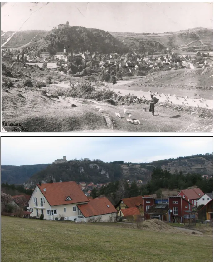
Fig. 1.1. and 1.2. – View from Strobelberg/Gänsleiten towards the castle in Kallmünz. The first photo comes from around

1920 (private archive Baptist Lell) and shows a varied landscape utilization including goose grazing on calcareous

grasslands. The present state (photo taken by P. Karlík in spring 2009) is typical of the extension of the built-up area,

intensive farming using machinery on well accesible places (in foreground) and the expansion of woods on less favourable

places (in the background).

(8)

8

Fig. 1.3. and 1.4. – The old photo of Kallmünz castle on the Schloßberg shows a rather tree- and shrubless landscape

with some woody plants restricted on close surroundings of the castle (photo taken by Baptist Lell in the year 1950). The

spontaneous expansion of woods and tree plantation is visible on recent picture taken by P. Karlík in early spring 2008.

(9)

9

Fig. 1.5. and 1.6. – In foreground is locality „Hutberg bei Krachenhausen“. This site is today a nature protected area and is managed by sheep grazing, but the intensity of the pasture is noticeably lower than before. The current image shows higher sward and juniper shrubs. The expansion of woods is visible on recently not managed slopes in backgrounds. The old photo comes from around 1930 (archive Verlag Lassleben). The present state was documented by P. Karlík in early spring 2008.

Emergence of new grasslands, definition of ancient and recent grasslands

However, the process of land-use change is not trivial and unidirectional, because in addition to

decline, many areas have also emerged. Thanks to the current evaluation of old maps in the GIS

(10)

10

environment, we have a number of regional studies providing accurate data (Mailänder 2005, Baumann 2006, Johansson et al. 2008, Poschlod et al. 2016).

New grasslands established on cultivated land, i.e. on arable fields or vineyards. Especially after the wine-pest (phylloxera, Daktulosphaira vitifoliae) epidemic in the 19th century grasslands replaced abandoned vineyards (Hard 1964, Illyes & Boloni 2007). New grasslands either results from spontaneous succession or were artificially established by sowing hayseed (Hard 1964).

The process of grassland creation enhanced from the middle of the 19th century when new agricultural techniques were introduced, resulting in increased production (Hard 1964, Baumann et al. 2005, Mailänder 2005). Arable farming on marginal land was further abandoned because of socio- economic and political changes. An important role played the gradual decrease in the importance of self-sufficiency, related to the improvement of transport and the industrialization of rural areas. Large areas of new semi-natural grasslands developed in numerous regions in Central Europe only around the middle and in the second half of the 20th century on less agriculturally favourable land (Osbornová et al. 1990, Mailänder 2005, Chýlová & Münzbergová 2008, Poschlod et al. 2008). In post-communist countries was increase during 90ties especially significant (Ruprecht 2005, Illyés &

Bölöni 2007, Lipský 2010, ČÚZK 2017).

Therefore, we may differentiate ancient and recent calcareous grasslands.We define ancient

grasslands as those that are at least 180 years old and recent grasslands as those that are marked as

arable fields at least on the first detailed maps published at the beginning of the 19th century of the

Central European landscape (first cadaster maps available from 1820s and 1830s) or on someyounger

maps (Mailänder 2005, Baumann 2006, Poschlod et al. 2008). An example of the distribution of

ancient and recent grasslands in the Kallmünz region is shown on the Fig. 1.7.

(11)

11

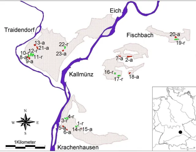
Fig. 1.7. – Changes in the distribution and status of calcareous grasslands in the surroundings of Kallmünz from 1830 to 1990. The ancient grasslands (continuous at least since 1830) are marked with green collor, recent grasslands (arisen between 1830-1990) are marked with yellow collor and grasslands lost between 1830-1990 are red. The map was created by intersection a layer of pastures (“Ödungen”) from the cadastre map of the 30ies of the 19th century with a layer of semi-natural dry grassland habitat on calcareous substrates biotopes surveyed in 1990. (Accordings to Blattner 2004 and Baumann 2006).

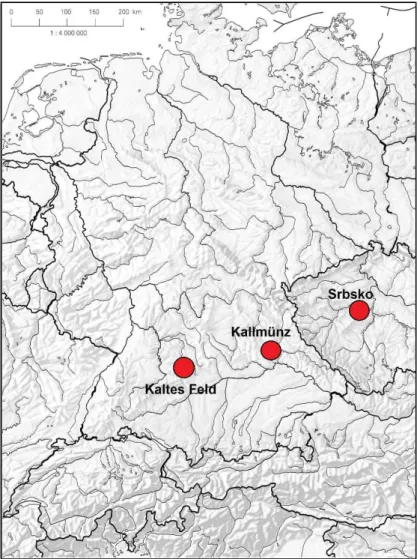
Overall, the presented dissertation deals with three territories in detail, all of which are famous and very valuable Natura 2000 sites (Fig. 1.8). For all three areas there is a typical mosaic of well- preserved ancient grasslands and recent grasslands of different age. There are differences in history (past management practices), topography, partly geology but the most important is climate. These regions lie along a subocenaic to subcontinental climatic gradient; in the west the rather humid Kaltes Feld, in the middle the somewhat drier Kallmünz and in the -east the sub-continental Srbsko in the Bohemian Karst (Fig. 1.8).

Fig. 1.8. – Geographical position of the three surveyed regions in the Central Europe.

(12)

12

Thesis outline

The objective of this thesis is to investigate the ecological differences between ancient and recent grasslands and try to explain the causes of these differences. The differences can be observed in many parameters, in aboveground flora and vegetation, in the composition and the size of soil seed bank and in soil chemical and physical properties. The results can be presented e.g. using indicator species or can be generalised using plant traits.

The breadth of topic that is adressed requires the use of a variety of methods. In the present study, classical field work, i.e. sampling of vegetation relevés or simple surveying of target species was supplemented by experiments in the greenhouse for the purpose to assess the seed bank and soil chemical and physical analyses. Due to the use of different map sources and the need to achieve high accuracy in site localization, it was necessary to work in a GIS environment.

The research presented in chapter 2 (History or abiotic filter: which is more important in determining the species composition of calcareous grasslands?) was conducted in the nature reserve “Kaltes Feld” located in the central part of the Jurassic mountains, in the so called Swabian Alb (southwestern Germany). I recorded there vegetation data from ten ancient and 12 recent grasslands. Some recent grasslands reached considerable age of 150 years. Furthermore, I pinpointed a broad set of environmental variables. I analysed data using both, univariate and multivariate statistical methods and I defined indicator species for ancient and recent grasslands fot the region of Kaltes Feld.

In chapter 3 (Identifying plant and environmental indicators of ancient and recent calcareous grasslands) I made analogical survey in another part of the Jurassic mountains, on the Franconian Alb near the small town Kallmünz (Bavaria, south Germany). The inclusion of this additional territory is a necessary step in deciding the extent to which the results, in particular the indicator species, can be generalized.

In next two chapters (chapter 4 and 5) I focused on the soil seed bank. I assessed composition and size of the seed banks using emergence method and compared it with aboveground vegetation to find out if there are still species indicating the former arable field use in recent grasslands.

In chapter 4 (Soil seed bank composition reveals the land-use history of calcareous grasslands) I investigated the soil seed banks in the two regions of the Jurassic mountains, where I already explored aboveground vegetation (see chapter 2 and 3).

In chapter 5 (Soil seed banks and aboveground vegetation of a dry grassland in the Bohemian Karst) I explored one region in the Bohemian Karst and thus I reached the climatic gradient of three regions, the rather humid Kaltes Feld, the somewhat drier Kallmünz and the sub- continental Srbsko in the Bohemian Karst.

Finally, the results of the previous chapters were reviewed with regard to their implications

for nature conservation and restoration practice (chapter 6: Perspectives of using knowledge about

the history of grasslands in the nature conservation and restoration practice).

(13)

13

Chapter 2

History or abiotic filter: which is more important in determining the species composition of calcareous grasslands?

Abstract

Dry calcareous grasslands belong to the most species-rich but also strongly endangered ecosystems of central Europe. Despite the dramatic loss of grasslands in the second half of the 20th century due to abandonment of land use or afforestation, also new grasslands have developed on former arable land. The main object of our study was to assess the effect of age on the vegetation and habitat properties of calcareous grasslands. We found that history (former land-use, age of habitats) of grassland localities is a fundamental attribute to both species composition of vegetation and habitat properties. Significant differences were found, especially in soil reaction and water-holding capacity.

Therefore, we can state that both history and habitat properties determine the recent species composition pattern. Consequently, it was possible to identify species indicating the historical status of the grasslands. Indicators for ancient grassland (i.e., patches continuously used as pastures at least since 1830) could be assigned to typical Festuco-Brometea species but also more widespread grassland species such as Carex flacca, Buphthalmum salicifolium, Carlina vulgaris, Cirsium acaule, Hippocrepis comosa and Scabiosa columbaria. Indicators for recent grasslands (i.e. patches temporarily farmed as arable fields after 1830) belong to different phytosociological classes as Festuco-Brometea but also Molinio-Arrhenatheretea, Trifolio-Geranietea sanguinei and Secalietea cerealis. Festuco-Brometea species restricted to recent grasslands were e.g. Thymus pulegioides subsp. carniolicus, Stachys alpina, Rhinanthus alectorolophus and Onobrychis viciifolia.

The two latter species are survivors from the former arable cultivation, the first was an arable weed and the second a widespread fodder plant, but are now considered to be characteristic species of calcareous grasslands. Therefore, we claim that the occurrence of these species indicate calcareous grasslands that were previously arable fields and that recent grasslands are a monument to historical land use. Rare and/or endangered species were not only found in ancient but also in recent grasslands.

Furthermore, recent grasslands have a high species diversity. Thus both, ancient and recent calcareous grasslands should be considered equally valuable from a nature-conservation point of view.

Keywords: ancient grasslands, biodiversity, calcareous grasslands, Central Europe, historical ecology, historical land use indicators, recent grasslands, Swabian Alb

Introduction

Calcareous grasslands belong mostly to the so-called semi-natural grasslands influenced and formed

by husbandry. Their existence dates back at least to the Neolithic (Dutoit et al. 2009) or Bronze Age

(Körber-Grohne & Wilmanns 1977, Thorley 1981, Ložek 1988, Ložek & Cílek 1995, Wilmanns

1997, Baumann & Poschlod 2008, Poschlod & Baumann 2010). Before the Neolithic Age dry

grassland species were restricted to small scale patches like rock outcrops although in some more

continental regions of Central Europe dry grasslands might have been formed from still existing

(14)

14

steppic vegetation due to early colonization and continuous settlement (Gradmann 1933, Pokorný 2005, Ložek 2007).

Furthermore, some non-forest species currently occuring in dry grasslands might have survived there throughout the Holocene due to grazing by wild animals (Vera 2000). Periods of dry grassland extension started probably in the Bronze Age but also the Roman Age and especially the High and Late Medieval Ages and the 18th and 19th century of Modern Times (Baumann 2006, Poschlod & Baumann 2010). The decrease started at the end of the 19th century (Quinger et al. 1994) having the strongest decline during the 1960s and 1970s (Mattern et al. 1980, 1992, Mauk 2005) due to altered farming practices as well as by increased imports of sheep wool from e.g., Australia and New Zealand which resulted in decline of sheep numbers (Poschlod & Wallis de Vries 2002). Since calcareous grasslands also belong to the most species-rich habitats in central Europe (Korneck et al.

1998, Wallis de Vries et al. 2002, Sádlo et al. 2007) they are now in the focus of conservation efforts and are listed in the Annex I of the Natura 2000 Habitats Directive (92/43/EEC).

However, also new grasslands have developed from former arable fields since mid of the 19 th century when agricultural techniques have improved (Hard 1964, Baumann et al. 2005, Mailänder 2005). Furthermore, after the wine-pest (Phylloxera) epidemy in the 19th century new grasslands have established on abandoned vineyards (Illyés & Bölöni 2007). Hard (1964) even states that they were artificially sown applying hayseed. A large proportion of recent grasslands has also developed in the middle and second half of 20th century in numerous regions in central Europe on less agricultural favourable sites when arable farming was abandoned because of socio-economical and political changes (Osbornová et al. 1990, Ruprecht 2005, 2006, Illyés & Bölöni 2007, Poschlod et al.

2008). Therefore, we may differentiate ancient and recent calcareous grasslands. We define ancient grasslands as those that are at least 180 years old and recent grasslands as those that are marked as arable fields at least on the first detailed maps published at the beginning of the 19th century of the Central European landscape (first cadaster maps available from 1820s and 1830s) or on some younger maps (Mailänder 2005, Baumann 2006, Poschlod et al. 2008).

The effect of habitat continuity on species richness and composition and habitat properties is recorded for forests (Peterken 1974, 1976, Peterken & Game 1981, 1984, Kubíková 1986, Koerner et al. 1997, Graae & Sunde 2000, Bellemare et al. 2002, Jacquemyn et al. 2003, Verheyen et al. 2003, Vojta 2007). A comparison of studies from different parts of Europe revealed a set of indicator species for ancient and recent forests (Wulf&Kelm 1994). The absence of ancient forest indicators in recent forests is attributed to either their dispersal limitation (Ehrlén & Eriksson 2000, Graae & Sunde 2000) or the lack of dispersal processes in the current landscape (Poschlod & Bonn 1998).

Until now, only few comparisons of ancient and recent grasslands exist which are related to species composition as well as habitat properties and identifying indicator species (Ejrnæs & Bruun 1995, Chýlová & Münzbergová 2008, Poschlod et al. 2008). There are however some studies related to populations of single species (Geertsema et al. 2002, Becker 2003, Herben et al. 2006) and species diversity (Austrheim et al. 1999, Bruun 2000, Bruun et al. 2001, Gustavsson et al. 2007, Pärtel et al.

2007, Waesch & Becker 2009). Other studies are related to the establishment of grasslands after

abandonment of arable fields and restoration of afforested grasslands. Succession on former arable

land to grasslands was described e.g., by Knapp (1979), Schmidt (1981), Soukupová (1984),

Osbornová et al. (1990) and Ruprecht (2005, 2006). Gibson & Brown (1991), Verhagen et al. (2001),

Pywell et al. (2002) and Kiehl & Pfadenhauer (2007) studied the establishment of grasslands on

former arable fields after restoration management. Von Blanckenhagen & Poschlod (2005)

(15)

15

investigated the re-establishment of calcareous grasslands after clear-cutting afforestations. Hirst et al. (2005) reported about the resilience of calcareous grasslands in military training areas after disturbance by military vehicles.

Like in recent forests, dispersal potential of the respective species both in space and time has been shown limiting species composition after reestablishment or restoration (Hutchings & Booth 1996). Grazing of domestic livestock was shown being the key factor in the dispersal of grassland species (Fischer et al. 1996, Stender et al 1997, Cosyns et al. 2005, Bugla 2008). Wells et al. (1976), therefore, stressed also time period after abandonment of arable fields being another key factor in the re-establishment of grasslands.

Summarizing, we can conclude that there is a lack in studies concerning how land use history affected species composition and habitat properties in grasslands. The following questions are addressed in the present paper: (i) What are the differences among ancient and recent calcareous grasslands regarding species richness and composition, selected physical and chemical soil properties? (ii) If there are any differences in vegetation are they caused either by the variable „land use history“ or by environmental variables or by both? (iii) Are there any plant-indicators for ancient and recent grasslands?

Material and methods Study area

The study was carried out in the nature reserve “Kaltes Feld” located in the central part of the Jurassic mountains Swabian Alb in southwestern Germany (Fig. 2.1). Altitude ranges from 650 to 781m above sea level. The climate is temperate, with mean annual precipitation of 1050 mm and a mean annual temperature of 7°C (DW 1979). Geological substrate consists of Jurassic bedrock (Malm) containing hard and soft layers resulting in a relief of steep slopes around a plateau (LGRB 2002, Geyer &

Gwinner 2008; see also Table 2.1). Soils are shallow, both on the slopes and on the plateau (Table 2.2). The main soil type is rendzina.

During the 18th and beginning of the 19th century there was a great increase in area of arable land due to the increasing human population after the strong decrease in the 17th century (the Thirty Years’ War, pest epidemies). Cultivation of marginal areas, however, was very labour-intensive. In the case of “Kaltes Feld”, the fields the farmers were cultivating were located some 200 to 300 altitudinal meters higher than their farms. Therefore, arable farming of distant and less fertile fields was abandoned in the middle of the 19th century when the first railways were constructed connecting rural areas with central market places and farm products were imported from more fertile regions (Mailänder 2005). At the same time, the “golden age” of sheep breeding inWuerttemberg started, which means that arable fields were turned rapidly into grasslands. Later in the 19th century, mineral fertilizers were introduced, which caused further abandonment of marginal areas (Poschlod et al.

2010). The last massive abandonment of arable fields in the study area occurred afterWorldWar II when the economic situation improved (Poschlod&Wallis de Vries 2002, Mailänder 2005).

Crops which were mostly cultivated in the past in the study region were spelt (Triticum spelta)

and oat (Avena sativa), potatoes (Solanum tuberosum), clover (Trifolium pratense but also Medicago

sativa) and sainfoin (Onobrychis viciifolia) (Königliches statistisch-topographisches Bureau 1870,

Gradmann 1950). The grasslands belong to the broadly conceived association Gentiano-Koelerietum

(alliance Mesobromion erecti), which is a typical example of mesophilous Central European

(16)

16

calcareous grasslands (Oberdorfer 2001, Chytrý et al. 2007). Flora and vegetation of the study area were already described by Alexejew et al. (1988) and Jandl (1988).

Study sites

Ancient and recent grasslands were selected using cadaster maps from 1830, and land-use maps from 1953 and 2002 which were made available by Mailänder (2005). As ancient grasslands patches we considered grasslands which were continuously marked as pastures since 1830. Recent grasslands were defined as patches which were marked as arable land at least on one of the older maps (1830, 1952) and as grasslands at least on the most recent map (2002).

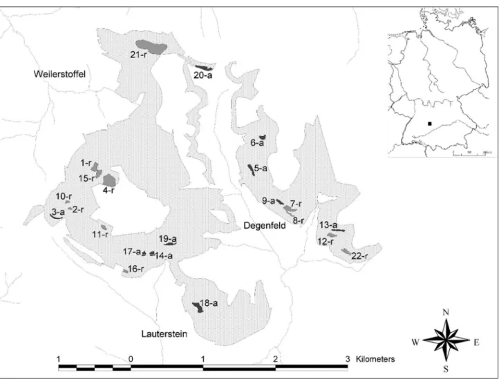
Ten ancient and 12 recent grasslands were selected. The higher number of recent grasslands was chosen due to generally greater variability of them (e.g., inclination, age, see also Table 2.2 and Fig. 2.2). Four recent grasslands on the plateau were exactly 150 years old (category “very old”

grassland), four other grasslands were between 55 and 150 years (“old” grassland) and four grasslands only about 50 to 60 years old (“young” grassland). The ancient and recent grasslands selected were roughly similar in terms of environmental characteristics like slope, exposure and soil depth.

Fig. 2.1. – Location of “Kaltes Feld” in Germany and that of the investigated ancient (dark grey, a) and recent (grey, r)

grasslands in the study area. Bright grey area is the nature conservation area. Position of brooks and villages are also

shown.

(17)

17 Table 2.1. – Geology of the localities.

Geology Number of ancient

grasslands plots

Number of recent grasslands plots

kimmeridgian marl-stone (ki1) 32 20

oxfordian marl stone (ox1) 10 5

solid limestone (ox2) 1 15

hard reef-limestone (joMu) 0 20

run-of-hill scree (qu) 7 0

Table 2.2. – Data of environmental variables in different age classes of grasslands. One-way ANOVA was applied to test for significant differences between at least two groups followed by Tukey HSD multiple comparisons. Different letters indicate significant differences between age classes. SD: Standard deviation; P: significance value; *** p<0.001; **

p<0.01; *p<0.05. ; ns.: result not significant. EIV = Ellenberg indicator value.

Variable Ancient

grasslands (N=50)

Very old (1855, plateau)

(N=20)

Old (<<1953)

(N=20)

Young (>1937,>1953)

(N=20)

One-way ANOVA

Mean

SD Mean SD Mean SD Mean SD F p Sign.

Mean Species number 37.52 6.50 40.60 a 4.26 38.05 a 8.62 38.80 a 6.07 1.10 0.352 ns.

Shannon-Wiener Index 3.15 a 0.22 3.18 a 0.20 3.03 a 0.38 3.10 a 0.25 1.44 0.234 ns.

Altitude (m a.s.l.) 665 ac 15.3 773 b 6.17 666 ac 30.23 650 c 36.92 131.33 <0.001 ***

Exposition (°) 210 a 31.9 222 a 100.02 229 a 69.61 189 a 14.59 1.98 0.122 ns.

Inclination (°) 17.82 5.70 2.80 b 2.17 14.80 ac 8.34 12.15 c 4.96 33.53 <0.001 ***

Soil depth (average; cm) 18.55 7.30 13.63 b 3.25 18.81 a 5.85 13.06 b 3.81 6.73 <0.001 ***

Cover herb layer (%) 77.18 10.1 77.35 a 11.09 84.35 a 13.42 80.90 a 11.22 2.31 0.081 ns.

Cover moss layer (%) 9.20 a 6.23 15.10 ab 10.95 12.40 a 12.85 7.30 ac 5.32 3.53 0.017 * Cover of stones (%) 2.66 a 5.20 0.00 bc 0.00 0.85 ac 2.01 0.00 bc 0.00 4.12 0.008 **

PDSI 21. December 3,30 a 0,88 1.72 b 0.19 2.74 a 1.30 3.01 a 0.57 16.57 <0.001 ***

PDSI 21. March 6.26 0.58 5.13 b 0.17 5.83 cd 0.93 6.08 acd 0.41 18.29 <0.001 ***

WHC (weight %) 59.92 9.08 81.61 b 9.29 67.23 a 10.05 73.14 b 15.95 21.29 <0.001 ***

pH(H

2

O) 7.60 a 0.08 6.84 b 0.58 7.57 ac 0.10 7.40 c 0.25 39.31 <0.001 ***

pH(CaCl

2

) 7.28 a 0.06 6.58 b 0.61 7.27 a 0.10 7.11 a 0.26 30.63 <0.001 ***

H

2

O-CaCl

2

0.32 a 0.09 0.26 a 0.13 0.29 a 0.10 0.29 a 0.09 2.17 0.096 ns.

Conductivity (μS) 130 a 15.8 86 b 31.22 117 a 14.66 133 a 25.35 23.78 <0.001 ***

K (mg/kg soil) 158 a 45.6 54 b 28.96 160 a 49.44 143 a 51.05 27.90 <0.001 ***

P (mg/kg soil) 18.51 6.35 8.23 b 3.49 19.03 a 6.45 17.43 a 6.72 15.69 <0.001 ***

EIV Light 7.40 a 0.08 7.32 b 0.08 7.31 b 0.05 7.32 b 0.12 9.71 <0.001 ***

EIV Temperature 5.48 a 0.08 5.44 a 0.10 5.54 b 0.11 5.65 c 0.05 23.37 <0.001 ***

EIV Continentality 3.72 a 0.10 3.60 b 0.15 3.86 c 0.13 3.87 c 0.15 21.24 <0.001 ***

EIV Moisture 3.89 a 0.14 4.09 b 0.15 3.87 a 0.21 3.87 a 0.11 10.77 <0.001 ***

EIV Soil reaction 7.48 a 0.09 6.91 b 0.25 7.45 a 0.13 7.43 a 0.17 71.70 <0.001 ***

EIV Nutrients 2.91 a 0.18 3.52 b 0.29 3.04 a 0.17 3.36 b 0.20 53.37 <0.001 ***

(18)

18

Vegetation data

Vegetation was recorded during July-August in seasons 2006 and 2007 on five 2m x 2m plots placed semi-randomly (with exclusion of rock, bush or strongly disturbed patches) in each grassland applying the Braun-Blanquet’s (1964) 9 grade abundance-dominance scale. For the data processing scale classes were transformed into percent values: 1 (r), 2 (+), 3 (1), 5 (2a), 8 (2m), 18 (2b), 38 (3), 63 (4), and 88 (5). For each plot we calculated species diversity using number of species (species richness) and Shannon-Wiener index. The Shannon–Wiener index of diversity (Begon et al. 1990) was calculated in CANO-DRAW (ter Braak & Šmilauer 2002).

Species occurring only in one plot (see Appendix) were excluded from multivariate analysis because they do not contribute to the explanation of vegetation patterns. This concerns 21 species of in 163 taxa in total. Four species (Rhinanthus minor, R. glacialis, Polygala vulgaris, P. comosa) were omitted because they could not be identified to the species level in case they did not flower. Also the hybrid Ononis spinosa x repens was omitted. Therefore, 137 taxa were included in the analysis.

Nomenclature follows Rothmaler (2005) for species and Oberdorfer (2001) for syntaxa.

Environmental data

For each plot data on environmental parameters were collected. This included geological substrate, altitude, inclination, exposition, cover of herb- and moss-layer, cover of stones, occurrence of ant- hills and two categories of current management (grazing or no grazing; shrubs cleared or not cleared).

Most localities of both, ancient and recent grasslands were underlain by marl-stone. Some localities occurred on solid limestone and on other rocks (see Table 2.1).

Data on latitude, inclination and exposure were used to calculate the potential direct solar radiation (PDSI). This was done by adding the cosines of angles between the sun and the plot surface at 15-minute intervals over a whole day. The calculation was done on the 21st day of each month between December and June following the description of Jeník & Rejmánek (1969). Most of the variability in species data was explained by winter months (December to March) probably due to the effect of the thickness and duration of the snow cover. Furthermore, the following soil physical and chemical properties were measured for each plot: soil depth, water holding capacity (WHC), pH(H2O), pH(CaCl2), conductivity, concentration of available potassium (K) and phosphorus (P) in the soil.

Soil depth was estimated by repeatedly (8 ×) thrusting an iron rod, 0.6 cm in diameter, into the soil. Water holding capacity was measured by collecting soil cores using a metal borer of a standard volume of 100 cm3 (diameter 56.4 mm, height 40 mm). After collecting each sample, soil within metal borer was saturated with water by placing on a permanently wet filter paper for 24 hours.

Then, the saturated samples were dried at 105°C until a constant weight. Water holding capacity was calculated using the following formula: WHC = (weight of water saturated soil – weight of dry soil)

× 100/ weight of dry soil.

For the measurement of soil chemical properties soil from 5 to 10 cm depth was collected at

three points within each plot and mixed afterwards. Soil was air dried and sieved through a 2 mm

sieve before the analysis. The methods for soil chemical analysis followed the standards given by

Verband Deutscher Landwirtschaftlicher Untersuchungs- und Forschungsanstalten (1991). Soil

(19)

19

reaction (pH) was measured in a 1:2.5 suspension of dry soil and distilled water (active soil acidity) or 0.01 M CaCl 2 (exchangeable soil acidity) after 1 hour using universal pH meter WTW SenTix41.

Conductivity was analysed in a 1:5 suspension of dry soil and distilled water with a WTW LF340 apparatus. Plant-available P and K were extracted by calcium acetate lactate (CAL). Phosphorus was measured photometrically after making the P content visible with ammoniumheptamolybdate. K was analysed with an atomic absorption spectrometer. Other variables were geographical coordinates and their combinations. This analysis was done to filter out possible spatial distribution effects of samples (Fortin & Dale 2009).

Data analysis

Differences between environmental parameters in grassland-age classes were analysed applying one- way analysis of variance (ANOVA) followed by a Tukey HSD test in SPSS 12.0 Program (Bühl &

Zöfel 2000). Unweighted mean Ellenberg indicator values (Ellenberg et al. 1992) for particular plots were calculated using the JUICE 6.5 Program (Tichý 2002) to test for additional variables. Juveniles of trees and shrubs were omitted from this calculation.

Ordination techniques were applied to determine the difference between the vegetation of ancient and recent grasslands and the influence of environmental factors. Methods based on the linear species response were chosen, which was supported by the length of gradient in DCA analysis (less than 3 S.D. units; ter Braak & Šmilauer 2002). Thus, Principal Components Analysis (PCA) and its constrained counterpart, Redundancy Analysis (RDA) were applied using the CANOCO for Windows 4.5 program package (ter Braak & Šmilauer 2002).

To estimate the influence of environmental factors, the eigenvalues of the corresponding ordination axes from unconstrained (PCA) and constrained (RDA) analyses were compared (Lepš &

Šmilauer 2003). Scaling is focused on inter-species correlations in order to facilitate visibility of species positions in biplots. Species scores were divided by standard deviation. Species coverages (in percent) were transformed using the formula y= (ln x + 1). Neither centering nor standardization were used for samples (vegetation plots). Centering, but not standardization was used for species.

Statistical significance of first canonical axe in RDA’s was determined using the Monte Carlo permutation test, with 1999 permutations and reduced model. Permutations were restricted to the split-plot design. Five vegetation plots within each grassland were not permuted split plots. Particular grasslands represent whole plots and were permuted completely at random. Floristic differences between ancient and young grasslands were analysed using RDA (length of gradient in DCA: 2.292).

We used only one explanatory variable, which was „History“. Other variables were used as covariables in the RDA in order to filter out different environmental variables and spatial gradients and to obtain only the effect of history on species composition. Significance of all potential covariables was at first tested by manual forward selection with the p-value = 0.05 (Monte Carlo test, 499 permutations). The following environmental variables were selected applying the forward- selection function: Altitude, inclination, soil depth (average), grazing, three variables for geology (joMu, ox2, ki1), PDSI on 21 December, PDSI on 21 February, phosphorus, pH(H 2 O), conductivity, cover of herb layer and geographical coordinates X and Y.

All variables except geology and management (grazing) were quantitative data. Geology and

management data were categorical. Due to strong correlation with other variables (high Inflation-

(20)

20

index in Canoco) altitude and PDSI of 21 February were excluded from the further analysis.

Therefore, in total 13 covariables were used for direct gradient analysis (RDA).

Various methods such as regression coefficients, scores on the first canonical axis in RDA history

and others were applied to detect indicator species for both, ancient and recent grasslands. These methods offered similar results, therefore, only the results from the fidelity calculation expressed with Phi-coefficient (Sokal & Rohlf 2001, Chytrý et al. 2002) are presented in this paper (Table 2.4).

Significance of fidelity for species belonging to ancient or recent grassland was calculated using Fischer`s exact test (p = 0.05). Data were processed using the JUICE 6.5 Program (Tichý 2002).

Results

Vegetation patterns

There were strong differences in ancient and recent grasslands, both in vegetation and environmental variables. The assesment of the basic vegetation pattern was performed by PCA analysis which shows distinct differences between plots of ancient and recent grasslands (ordination diagram not shown).

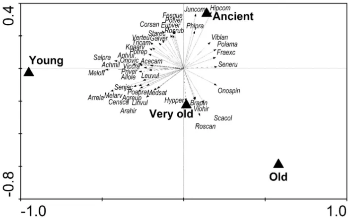
The majority of plots was well separated. The main floristic variability (gradient along first axis AX1) can be interpreted by the variables geology and history (see also Fig. 2.2, 2.3, 2.4). The vegetation pattern can be differentiated into three groups (PCA diagram not shown, see Appendix 2.1). Nearly all plots of the ancient grasslands and only few of recent grasslands are characterised by many basi- and calciphilous grassland species such as Carex flacca, Buphthalmum salicifolium, Carlina acaulis subsp. caulescens, Hippocrepis comosa and Ligustrum vulgare. The plots which include species of this group are characterised by the occurrence on marl-stone (ki1-Lacunosamergel). There are two groups of recent grasslands. The first group is characterised by many mesophilous grassland species such as Avenula pubescens, Cynosurus cristatus, Dactylis glomerata, Festuca pratensis, Trisetum flavescens, Cerastium holosteoides, Trifolium pratense, T. repens and Veronica chamaedrys, some acidophilous species such as Agrostis capillaris and Luzula campestris and few arable weeds and ruderals. This group is related to the 150 years old grasslands on the plateau underlain by slowly weathered reef-stone. Another group of recent grasslands can be identified by its occurrence on mainly solid limestone and by calciphilous species such as Salvia pratensis, Melampyrum arvense, Centaurea scabiosa and hemerophilic species as Medicago sativa and Convolvulus arvensis.

If grasslands were constrained with factor “history” and differentiated into four age classes, the general pattern remained similar (Fig. 2.4). A synoptic table of the original floristic data is provided in the Appendix 2.1.

Environmental variables

Although there were no differences in species diversity parameters, there were clear differences in

habitat properties (excepting cover of herb layer and exposition) of ancient and recent grasslands

(Table 2.2) which became already obvious from a PCA correlating a larger amount of environmental

variables (Fig. 2.2).

(21)

21

Fig. 2.2. – Principal components analysis (PCA) presenting the correlations between a larger amount of environmental variables (geology [joMu, ox 1, ox2, ki1, qu; see Table 2.1 for details], history, altitude, inclination, PDSI of all seven months, soil depth (average and median), pH(H

2

O), pH(CaCl

2

), conductivity, plant available potassium (K) and phosphorus (P), number of species, cover of herb (E1) and moss (E0) layer, cover of stones, grazing and geographical coordinates X and Y in an ordination diagram (squares – ancient grasslands, circles – recent grasslands). Environmental variables were treated like “species”.

Ancient grasslands exhibited a higher inclination than recent grasslands. Accordingly, solar radiation was also higher in ancient grasslands. Soil was a little bit deeper in ancient than in recent grasslands. Soils of recent grasslands were more acidic. More information is presented in Table 2.2.

Both, standard deviations of most environmental parameters (Table 2.2) as well as

multivariate analysis (Fig. 2.2) show clearly that the environment in recent grasslands is much more

heterogenous than in ancient grasslands. If recent grasslands were divided in three age classes, a more

differentiated pattern appeared showing that the oldest recent grasslands were situated on the plateau

with partly strong differences in several environmental parameters whereas the grasslands from the

(22)

22

younger recent grasslands (60 to 150 and 50 to 60 years old) were more similar to ancient grasslands (Table 2.2).

History

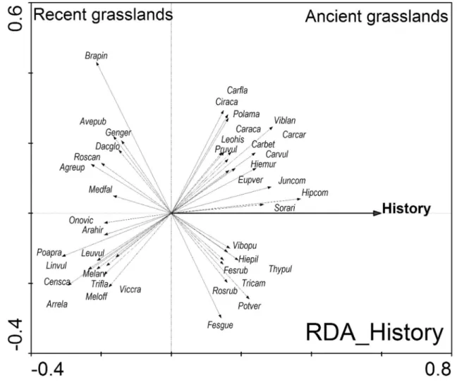
The influence of the land-use history was calculated using the direct linear analysis (RDA). History (RDA history ) explains 2/3 of variability along the main floristic gradient comparing to RDA with all variables. However, history is correlated with other environmental variables when the results of AX1 in both RDA’s, RDA history and RDA history+covariables , are compared. Therefore, the eigenvalues of the first ordination axes (AX1) from PCA and RDA history+covariables were compared, which showed that 21% of the vegetation pattern along the main floristic gradient could be attributed to the net influence of history. The permutation test of the first axis was highly significant (Table 2.3).

Fig. 2.3. – RDA

history+covariables

analysis constrained with factor “history”, reflecting the continuous ancient grasslands and

discontinuous recent grasslands. The effect of 13 covariables was subtracted. Only the 44 most correlated species (species

fit range > 10%) are presented. For the full species names see Appendix 2.1.

(23)

23

Fig. 2.4. – RDA

age groups+covariables

analysis constrained with four variables representing different age-groups of grasslands.

“Ancient” grassland are continuously used as pastures at least since 1830. Category “very old” represent exactly 150 years old grasslands, “old” represent grasslands between 55 and 150 years and “young” means grasslands only about 50 to 60 years old. The effect of covariables was subtracted. Only the 43 most correlated species (species fit range > 4%) are presented. For full species names see Electronic Appendix 1.

Table 2.3. – Results of the ordination analysis (PCA, RDA). Plots n = 110, species n = 137, environmental variables and covariables n = 14 (history, three variables for geology, inclination, PDSI on 21 December, average soil depth, pH(H2O), conductivity, phosphorus, cover of herb layer, grazing and geographical coordinates X and Y). For detailed explanation see text and Figs 2–4; %variance: cumulative percentage variance of species data explained by four ordination axes, % all AX: variance explained by all the canonical axes, F-statistics and significance (p-value) of Monte Carlo permutation test of significance of first canonical axis (1.999 permutations under reduced model).

Ordination analysis Environmental variables

Covari- ables

% variance % all AX F-stat p-value

AX1 AX2 AX3 AX4

PCA - - 16.3 26.2 33.3 38.6 - - -

RDA 14 0 13.7 22.2 26.6 30.5 42.7 15.118 <0.001

RDA

history

1 0 9.4 20.1 29.6 35.7 9.4 11.162 <0.001

RDA

history+covariables

1 13 3.5 10.4 16.5 21.5 3.5 3.481 <0.001

RDA

age groups

4(3) 0 12.7 18.8 21.1 30.5 21.1 15.490 <0.001

RDA

age groups+covariables

4(3) 13 3.9 6.9 8.7 14.8 8.7 3.763 <0.001

Indicators for ancient and recent grasslands

On the RDA history+covariables biplot (Fig. 2.3) species are shown according to their position along the

first canonical axis constrained by history. On the left side of the diagram species typical for recent

(24)

24

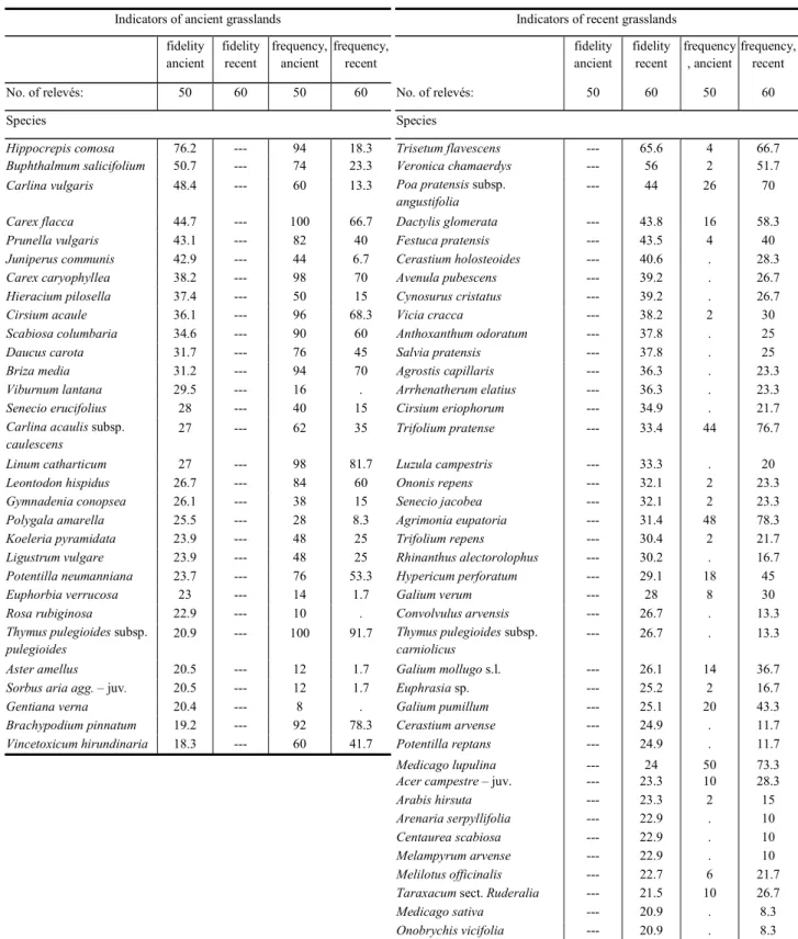
grasslands are displayed, in contrast to this group on the right side species typical for ancient grasslands. The application of different analyses to calculate the indicator value of species related to history such as fidelity expressed by Phi coefficient, regression coefficients or scores on the first canonical axis in RDA history provided similar results. Therefore, only the results from the fidelity analysis are presented here (Table 2.4). This analysis clearly show that in the case of ancient grasslands indicators were nearly not exclusive which was, however, the case in recent grasslands.

Strong indicators for ancient grasslands were Carex caryophyllea, C. flacca, Bupthalmum salicifolium, Carlina vulgaris, Cirsium acaule, Hippocrepis comosa and Scabiosa columbaria.

Species exclusively indicating recent grasslands are Anthoxanthum odoratum, Avenula pubescens, Cynosurus cristatus, Dactylis glomerata, Cerastium holosteoides, Medicago sativa, Melampyrum arvense, Onobrychis viciifolia, Rhinanthus alectorolophus and others. The RDA indicated a different indicator strength for some species when environmental covariables were subtracted due to the preference/non-preference of species for specific environmental conditions. Such substraction allows a better detection of the real effect of history. When covariables are substracted the following species of both ancient and recent grasslands had a remarkably lower indicating power: Achillea millefolium, Agrostis capillaris, Cynosurus cristatus, Galium molugo and Trifolium pratense (all from recent grasslands occurring on the plateau), Daucus carota and Scabiosa columbaria (both from ancient grasslands growing on soils with higher pH and relatively high content of nutrients, especially potassium). However, other species had a stronger indicating power after substraction of covariables.

These were species growing under intermediate environmental conditions such as e.g., Thymus

pulegioides s.str. and Viburnum lantana in ancient grasslands or Centaurea scabiosa, Medicago

sativa, Melampyrum pratense and Onobrychis viciifolia in recent grasslands.

(25)

25

Table 2.4. – Synoptic table including indicator species of both ancient and recent grasslands. Species are sorted by a fidelity measure (presence/absence data) expressed in terms of the Phi coeficient (calculation by JUICE 6.5 Program;

Tichý 2002). Only those species with significant fidelity to each group are listed (P = 0.05; Fischer’s exact test). Number of plots n = 50 for ancient and 60 for recent grasslands. The percentage frequency of each species in each group is given.

Indicators of ancient grasslands Indicators of recent grasslands

fidelity ancient

fidelity recent

frequency, ancient

frequency, recent

fidelity ancient

fidelity recent

frequency , ancient

frequency, recent

No. of relevés: 50 60 50 60 No. of relevés: 50 60 50 60

Species Species

Hippocrepis comosa 76.2 --- 94 18.3 Trisetum flavescens --- 65.6 4 66.7

Buphthalmum salicifolium 50.7 --- 74 23.3 Veronica chamaerdys --- 56 2 51.7

Carlina vulgaris 48.4 --- 60 13.3 Poa pratensis subsp.

angustifolia

--- 44 26 70

Carex flacca 44.7 --- 100 66.7 Dactylis glomerata --- 43.8 16 58.3

Prunella vulgaris 43.1 --- 82 40 Festuca pratensis --- 43.5 4 40

Juniperus communis 42.9 --- 44 6.7 Cerastium holosteoides --- 40.6 . 28.3

Carex caryophyllea 38.2 --- 98 70 Avenula pubescens --- 39.2 . 26.7

Hieracium pilosella 37.4 --- 50 15 Cynosurus cristatus --- 39.2 . 26.7

Cirsium acaule 36.1 --- 96 68.3 Vicia cracca --- 38.2 2 30

Scabiosa columbaria 34.6 --- 90 60 Anthoxanthum odoratum --- 37.8 . 25

Daucus carota 31.7 --- 76 45 Salvia pratensis --- 37.8 . 25

Briza media 31.2 --- 94 70 Agrostis capillaris --- 36.3 . 23.3

Viburnum lantana 29.5 --- 16 . Arrhenatherum elatius --- 36.3 . 23.3

Senecio erucifolius 28 --- 40 15 Cirsium eriophorum --- 34.9 . 21.7

Carlina acaulis subsp.

caulescens

27 --- 62 35 Trifolium pratense --- 33.4 44 76.7

Linum catharticum 27 --- 98 81.7 Luzula campestris --- 33.3 . 20

Leontodon hispidus 26.7 --- 84 60 Ononis repens --- 32.1 2 23.3

Gymnadenia conopsea 26.1 --- 38 15 Senecio jacobea --- 32.1 2 23.3

Polygala amarella 25.5 --- 28 8.3 Agrimonia eupatoria --- 31.4 48 78.3

Koeleria pyramidata 23.9 --- 48 25 Trifolium repens --- 30.4 2 21.7

Ligustrum vulgare 23.9 --- 48 25 Rhinanthus alectorolophus --- 30.2 . 16.7

Potentilla neumanniana 23.7 --- 76 53.3 Hypericum perforatum --- 29.1 18 45

Euphorbia verrucosa 23 --- 14 1.7 Galium verum --- 28 8 30

Rosa rubiginosa 22.9 --- 10 . Convolvulus arvensis --- 26.7 . 13.3

Thymus pulegioides subsp.

pulegioides

20.9 --- 100 91.7 Thymus pulegioides subsp.

carniolicus

--- 26.7 . 13.3

Aster amellus 20.5 --- 12 1.7 Galium mollugo s.l. --- 26.1 14 36.7

Sorbus aria agg. – juv. 20.5 --- 12 1.7 Euphrasia sp. --- 25.2 2 16.7

Gentiana verna 20.4 --- 8 . Galium pumillum --- 25.1 20 43.3

Brachypodium pinnatum 19.2 --- 92 78.3 Cerastium arvense --- 24.9 . 11.7

Vincetoxicum hirundinaria 18.3 --- 60 41.7 Potentilla reptans --- 24.9 . 11.7

Medicago lupulina --- 24 50 73.3

Acer campestre – juv. --- 23.3 10 28.3

Arabis hirsuta --- 23.3 2 15

Arenaria serpyllifolia --- 22.9 . 10

Centaurea scabiosa --- 22.9 . 10

Melampyrum arvense --- 22.9 . 10

Melilotus officinalis --- 22.7 6 21.7

Taraxacum sect. Ruderalia --- 21.5 10 26.7

Medicago sativa --- 20.9 . 8.3

Onobrychis vicifolia --- 20.9 . 8.3

Trifolium campestre --- 20.9 . 8.3

(26)

26

Discussion

Vegetation pattern, history and environmental parameters

There were no differences in species richness in ancient and recent grasslands, however, species composition strongly differed. These differences could be assigned to both habitat properties and history. Percentages of explained variability on AX1 by particular variables in the RDA analysis without covariables were: Geology (marlstone x other) 10.9; Geology (hard reef-limestone x other) 10.7; Altitude 9.5; History (ancient x recent) 9.4; pH(H 2 O) 9.1; Inclination 8.5; PDSI 21.March 7.0 (see also Fig. 2.2 for correlations between variables).

The relationship between the vegetation of grasslands and former land use was still very clear and significant if the influence of other variables was subtracted (Table 2.3). The influence of history was even stronger, 4.8 instead of 3.5%, when the four recent grasslands situated on the plateau, which is strongly affected by other environmental parameters such as geology, were omitted. A similar strong effect of history on the composition of the vegetation is reported byHermy et al. (1999),who compared ancient and recent forests.

The geomorphological and soil parameters of the ancient and recent grasslands also differed.

Arable field use was correlated often with a lower inclination – although some recent grasslands occurred on steep (> 20°) slopes – which are not only easier to plough but also are less affected by soil erosion. Despite this soil depth is significantly lower in recent grasslands, which clearly shows that soil erosion occured during the arable field phase. There was a slight positive correlation between soil depth and slope inclination (Pearson correlation coefficient r = 0.229, P = 0.016, n = 110). Based on many local studies, Bork et al. (1998) reveal that soil erosion occurred in historical times to a much greater extent than today and argue that this is because (i) the area of arable fields was much greater and (ii) the plant cover of arable fields was less dense.

Whereas there were no differences in the cover of the herb and moss layers, cover of stones was significantly different, reflecting the fact that during the period of arable field use stones were removed by hand, often still visible at the edges of recent grasslands or in recent forests, where there are deposits of long heaps of stones.

In terms of soil physical and chemical properties those of recent grasslands have a higher water holding capacity than those of ancient grasslands. This fact can be explained by the geological substrate of most of the ancient grasslands, which is marlstone, and the resultant soil dense and loamy.

Higher water holding capacity may explain the higher number of mesic grassland species. Contents of potassium and phosphorus, the latter often the limiting factor on calcareous soils (Janssens et al.

1998, Carroll et al. 2003), were significantly lower in the very old grasslands due to the specific abiotic conditions prevailing on the plateau (Table 2.2). However, other authors report high nutrient levels in soil even after almost 2000 years of arable field use (Dupouey et al. 2002). In our case nearly no fertilizer was applied, because of the great altitudinal difference between farms and fields, except that provided by occasional hurdling by sheep during the stubble phase, which was still the case even during the 1950s (Mailänder 2005). Finally, tillage caused the decomposition of humus and harvesting of crops continuously extracted nutrients. This pattern, however, contrasts with the vegetation pattern of recent grasslands, where there are more species indicating rather high nutrient supply (N-value, Table 2.2). These indicators are particularly associated with the plateau (“very old”

grasslands). This might be explained by the fact that highly productive species are also able to thrive

(27)

27

at low phosphorus concentrations (from 20 mg P/kg soil; Hejcman et al. 2007, 2009) and that the indicator values for terrestrial plants only take into account nitrogen and ignore the fact that P and K may be limiting under certain conditions (Schaffers & Sýkora 2000, Niinemets & Kull 2005, Chytrý et al. 2009).

Vegetation patterns and flora

Differences in vegetation patterns were associated with ecological or phytosociological plant species groups. Recent grasslands were phytosociologically more heterogenous and, unlike ancient grasslands, could not clearly be assigned to a certain community. Ancient grassland species could be clearly assigned to Festuco-Brometea (Oberdorfer 2001, Chytrý & Tichý 2003), whereas recent grassland species belong to different classes, namely Festuco-Brometea but also Molinio- Arrhenatheretea, Trifolio-Geranietea sanguinei and Secalietea cerealis or even crop plants.

The occurrence of arable weed species in recent grasslands, such as Convolvulus arvensis, Cerastium arvense and the hemiparasitic species, Melampyrum arvense and Rhinanthus alectorolophus, strongly feared in former times since they strongly decreased crop yield (Gradmann 1950), is reported by other authors (Dutoit & Alard 1995, Poschlod & Wallis de Vries 2002, Dutoit et al. 2004). However, formerly cultivated plants like Dactylis glomerata, Medicago sativa, Melilotus officinalis, Onobrychis viciifolia and/or Trifolium pratense, still occur in recent grasslands; the last one, however, is also frequent in ancient grasslands (Table 2.4, Electronic Appendix 2.1). Some of these species are not indigenous. Melilotus officinalis is an archaeophyte and was probably introduced with unclean seed (Lohmeyer & Sukopp 1992). Onobrychis viciifolia is a neophyte and was introduced as a fodder plant (Kowarik 2003). Cultivation of Dactylis glomerata started in the 18th century (Stebler & Schröter 1902). Medicago sativa and Trifolium pratense were widely grown as fodder plants on nutrient-poor soils and are even mentioned as cultivated in the study region (Königliches statistisch-topographisches Bureau 1870, Gradmann 1950). Melilotus officinalis was often sown because of its medicinal properties, as a bee plant and to improve soil conditions. The medical power of field melilot was well known even in prehistorical times. In certain regions it was delivered in huge quantities to pharmacies and drugstores (Hegi 1966). The cultivation of Onobrychis viciifolia started in France during the 15th century and in Germany at the beginning of the 18th century, especially on nutrient-poor calcareous soils, which made it possible for the first time to transform calcareous grassland intomore productive arable fields for fodder production (Stebler&

Schröter 1902).

The largest proportion of recent grassland species are either mesotrophic (Molinio- Arrhentheretea) or calcareous (Festuco-Brometea) grassland species like Anthoxanthum odoratum, Arrhenatherum elatius, Avenochloa pubescens, Cerastium holosteoides, Cynosurus cristatus, Dactylis glomerata, Festuca pratensis, Poa pratensis, Trisetum flavescens, Trifolium pratense, Vicia cracca or Arabis hirsuta, Ononis repens, Salvia pratensis, Thymus pulegioides subsp. carniolicus.

Salvia pratensis and Centaurea scabiosa, both diagnostic species of Festuco-Brometea, occurred

only in the most recent grasslands, which are 50–60 years old. The absence in ancient grassland can

be explained by the fact that these species rarely naturally occur at higher altitudes such as in the

study area. Their occurrence in recent grasslands may be explained by tradition of hayseed application

after abandonment of arable field use, which was applied extensively during the 19th and beginning

of the 20th century, the period of the famous grassland construction schools in Germany (Häfener

1847, Hard 1964, Schröder-Lembke 1983, Poschlod&Wallis de Vries 2002). In contrast to recent

(28)

28

grasslands, characteristic species of ancient grasslands were mainly typical calcareous grassland species (Table 2.4). These indicator species patterns correspond to those reported by Röder et al.

(2006) based on a comparison of one ancient and one recent grassland located at Garchinger Haide north of Munich.

As there are species of plants that are exclusive indicators of ancient forests (Wulf & Kelm 1994) it is surprising that there are no such indicators for old grasslands. However, this may be due to the fact that recent grasslands were not strongly isolated from ancient grasslands and sheep grazing in the study area maintained a continuous seed input from ancient to recent grasslands. Sheep are known to be one of the most important and effective dispersal vectors in Central-European man-made landscapes (Fischer et al. 1996, Poschlod et al. 1996, Poschlod&Bonn 1998). There are, however, many exclusive species of recent grasslands, which may be simply explained by their former conversion into arable fields, which resulted in the establishment of new species and once established they have persisted even though the habitat has changed.

Conclusions and perspectives

Summarizing, history affects the vegetation pattern more than environment, except for the recent grasslands on the plateau. Therefore, future vegetation studies should include the results of not only floristic and environmental but also historical analyses. Contrary to the commonly held opinion that more recent habitats have little or no nature conservation value (Waesch & Becker 2009), recent grasslands may contain rare and/or endangered species such as Gentianella germanica, Gymnadenia conopsea and in the case of Melampyrum arvense even an exclusive species. Furthermore, a part of the regional calcareous grassland species pool was also restricted to recent grasslands (e.g., Thymus pulegioides subsp. carniolicus, Rhinanthus alectorolophus, Stachys alpina). Therefore, recent grasslands may have a high conservation value and should be considered in future management plans of calcareous grassland landscapes.

Acknowledgements

We thank Sonja Mailänder; without her historical analysis this study would have been impossible.We

also thank Michaela Adlmüller, Günter Kolb and Ivan Větvička for technical help with the soil

analysis. Jörg Mauk from the regional agency for Nature Conservation (Regierungspräsidium

Stuttgart) and the “Schwäbischer Albverein” supported us during the field work. Thanks also to

František Krahulec and Tomáš Tichý for valuable comments, and Tony Dixon for improving our

English. This work was sponsored by the Scholarship Programme of the German Federal

Environmental Foundation “DBU” (project: AZ 20006/837). Finalization of the paper was partly

supported by MSMT ČR project no. 2B06012.

Abbildung

Fig. 1.1. and 1.2. – View from Strobelberg/Gänsleiten towards the castle in Kallmünz. The first photo comes from around  1920  (private  archive  Baptist  Lell)  and  shows  a  varied  landscape  utilization  including  goose  grazing  on  calcareous  gras
Fig. 1.7. – Changes in the distribution and status of calcareous grasslands in the surroundings of Kallmünz from 1830 to  1990
Fig. 2.1. – Location of “Kaltes Feld” in Germany and that of the investigated ancient (dark grey, a) and recent (grey, r)  grasslands in the study area
Table 2.2. – Data of environmental variables in different age classes of grasslands. One-way ANOVA was applied to test  for significant differences between at least two groups followed by Tukey HSD multiple comparisons
+7

Referenzen

ÄHNLICHE DOKUMENTE

Alliaria petiolata Lasioglossum calceatum Anemone sylvestris Bombus pratorum Anemone sylvestris Bombus terrestris Anthyllis vulneraria Bombus hortorum Aquilegia vulgaris

The fourth chapter examines the effects of landscape composition, habitat connectivity and local management (grazing, mowing or abandonment) on the species

vesca (per plant) is characterized in Tab. Competition reduced shoot, root and total biomass by approximately 70% and significantly increased shoot to root

Summary of linear mixed-effect models with meadow fitted as random factor, testing the effects fertilizer (kg N ha − 1 year − 1 ; including quadratic term when significant)

To examine the effect of different types of forest edge on the specialized open- land gastropod community of nutrient-poor grasslands, we assessed the diversity and abundance of

Because unfertilized meadows harbor the most species-rich plant communities (K. Stöcklin, unpublished data), and because the higher land use diversity in Romanic

The research questions addressed in this paper are whether historical and recent observations of upper limits of vascular plants differ in altitude and if such shifts are

The regional species pool of the boreo-nemoral grasslands contains more than 400 vascular plant species, while the size of the community pool is, on average, 115–130 species;