EXPEDITION PROGRAMME PS120
Polarstern
PS120
Port Stanley - Las Palmas - Bremerhaven 2 June 2019 - 29 June 2019
Coordinator: Rainer Knust Chief Scientist: Karen Wiltshire
Alfred-Wegener-Institut Helmholtz-Zentrum
für Polar- und Meeresforschung Am Handelshafen 12
D-27570 Bremerhaven
Telefon: ++49 471 4831- 0 Telefax: ++49 471 4831 – 1149 E-Mail: info@awi.de
Website: http://www.awi.de
Email Coordinator: rainer.knust@awi.de Email Chief Scientist: karen.wiltshire@awi.de
PS120
02 June 2019 – 29 June 2019
Port Stanley - Las Palmas - Bremerhaven
Chief Scientist Karen Wiltshire
Coordinator
Rainer Knust
PS120
Ocean and Climate:
Training on a South-North Atlantic Transect (transit)
02 June – 21 June 2019 Port Stanley – Las Palmas
21 June - 29 June 2019 Las Palmas - Bremerhaven
Chief Scientist Karen Wiltshire
Coordinator Rainer Knust
Contents
1. Überblick und Fahrtverlauf 2
Summary and Itinerary 2
2. South North Atlantic Training 2019 (SoNoAT) 4
3. Testing of Sensors and Calibration of Measuring System for
MOSAIC 8
4. Testing of an En-Route Measuring System for Combined,
Continuous Measurements of PCO2 and Methane in the Surface
Water 9
5. Bathymetric Mapping and Geophysical Underway Measurements 10
6. Medical Devices Check Up 11
7. Teilnehmende Institute / Participating Institutes 12 8. Fahrtteilnehmer / Cruise Participants Leg 1 and 2 15
9. Schiffsbesatzung / Ship's Crew 18
1. ÜBERBLICK UND FAHRTVERLAUF
K.H. Wiltshire, P. Lemke, E. Brodte Alfred-Wegener-Institut
Die Transitfahrt von Port Stanley über Las Palmas nach Bremerhaven startet am 02.06.2019 und endet am 29.06.2019 in Bremerhaven.
Die Fahrt steht ganz im Zeichnen der studentischen Ausbildung und bedient die Schiff- vorbereitungen für MOSAIC. Eine internationale Gruppe von 25 Studierenden aus 23 Ländern wird während einer "schwimmenden Sommerschule" in Techniken der Ozeanographie und der Fernerkundung geschult. Dabei sollen sie Methoden der Probennahme, der Aufarbeitung der Proben und den Umgang mit erhobenen Daten lernen.
Im Rahmen in der Vorbereitung der anschließenden MOSAIC Expeditionen werden Sensoren kalibriert und die Implementierung ins System getestet, um einen reibungslosen Ablauf während des MOSAIC Programms vorzubereiten. Neben der sensor-technischen Vorbereitungen wird auch die medizinische Abteilung neuorganisiert.
Als weitere Aufgabe während der Transitfahrt werden chemische und physikalische Messungen zum Energieaustausch zwischen Ozean und Atmosphäre durchgeführt. Zudem bekommen die Studenten eine Einführung in die Physik des Klimasystems, in die internationalen Klimaverhandlungen und Datenanalyse, Mikroplastik & EDNA.
Dem „shipboard training“ geht ein dreitägiger Workshop an Land voraus, auf dem grundlegende Arbeitsweisen, Methoden und Programme zur späteren Nutzung an Bord vorgestellt werden.
Die "schwimmende Sommerschule" ist ein gemeinsames Projekt zwischen dem Alfred- Wegener-Institut Helmholtz-Zentrum für Polar- und Meeresforschung, NF- POGO Zentrum für Exzellenz und dem OCEAN TRAINING PORTAL (OTP). Die Sommerschule wird durch die Nippon Foundation / NF- POGO Centre of Excellence, ATLANTOS und das OTP finanziert und von REKLIM (Helmholtz Verbund Regionale Klimaveränderung) und PORTWIMS (Portugal Twinning for innovation and excellence in marine science and earth observation) unterstützt.
Am 29.06.2019 wird Polarstern in Bremerhaven einlaufen und beendet damit die Expedition PS120.
SUMMARY AND ITINERARY
The transit cruise from Port Stanley to Bremerhaven will begin on 02.06.2018 and will end on the 29.06.2019.
The cruise is primarily dedicated to the training of students and the preparation and testing of onboard equipment for the upcoming MOSAIC project. During a “floating summer school” an international group of 25 students from 23 countries will be trained in basic techniques of
oceanography and remote sensing on a North-South transect from Port Stanley to Bremerhaven (South North Atlantic Training; SoNoAT). The participants will learn how to take samples, how to process them and deal with the accompanying data. The main water masses between the Atlantic and the North Sea will be characterized in terms of their hydrographic features down to a depth of approx. 500 m and more.
In preparation for the following MOSAIC expeditions sensors will be re-calibrated and configured to fit into the board systems. This should assure the functionality during the MOASIC programme, the scholar will be involved in the sensor testing. Additional to the sensors the medical equipment will be inventoried and updated during this cruise.
A further focus during the transit cruise will be physical and chemical measurements as well as detection of mircoplastics and EDNA. In addition, the students will get an introduction into the physics of the climate system, international climate negotiations and data analyses.
Prior to the shipboard training a three day workshop will be held land-based to prepare the scholars in application and usage of programming tools and methods.
The floating summer school is a joint project between the Alfred Wegener Institute Helmholtz-Centre for Polar- and Marine Research, the POGO Centre of Excellence, ATLANTOS and the OCEAN TRAINING PORTAL (OTP). It is funded by the Nippon Foundation / POGO Centre of Excellence and the OTP and supported by REKLIM and PORTWIMS (Portugal Twinning for innovation and excellence in marine science and Earth observation).
Polarstern is scheduled to arrive in Bremerhaven on 29.06.2019 and thus will end the expedition PS120.
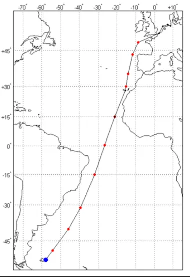
Abb. 1: Der generelle Kurs für PS120 Fig. 1: The projected course plot PS120
2. SOUTH NORTH ATLANTIC TRAINING 2019 (SoNoAT)
K. Wiltshire (AWI), P. Lemke (AWI), E. Brodte (AWI), P. Croot (NUIG), C. Gregory (NUIG),K.
Carstens (AWI), A. Heins (MPI), I. Kirstein (AAU), T. Keck (Pandata GmbH) L. Krug (POGO), M. Gomez (MARE-FCUL), S. Orlic (IRB), S. Gasso (ESSIC-UMD/NASA), P. von Dassow (UC), E. Sauter (AWI), J. El. Kassar (FUB), T. Keck , M. Scharfe (AWI)
Objectives
Aim of the floating summer school is to chart and characterize different water bodies with a special emphasis on nutrients along a South–North Atlantic Transect, as part of training exercise for capacity building in oceanography. An international group of 25 students (mostly graduate level and doctoral candidates) will be trained in basic oceanographic principles including seagoing methods and sampling associated with these, as well as micro plastic and
eDNA in water samples. The cruise track will cross-coastal, shelf and open Atlantic Ocean waters. Specifically, participants will learn how to sample and analyse the ocean properties as “ground truth” information for remote sensing information.
Intended study objectives of the floating summer school include:
- Differentiation of different water masses via temperature, salinity, turbidity etc.
- Localization of thermocline
- Detection of salinity gradients, turbidity
- Detection of micro plastics and plastics along the transect - Introduction of modern molecular biology techniques
- Comparison of ground-truth data with remote sensing (in cooperation with land-based workshop as pre cruise introduction)
- Measurements of atmospheric properties - Studies of climate physics
- Introduction into the international climate negotiations
Work at sea
The maps of the planned stations are shown in Fig. 1.
After embarkation, students will present their research projects (Master or PhD) in short talks. They will be provided background literature for the cruise. All participants need to pick a topic to be followed in discussion groups that will take place regularly during the cruise.
Topics comprise oceanography and climate & meteorology. Station work will take place along the transect at different shelf, slope and deep sea areas.
Deployed instruments comprise eXpendable Bathy/Thermographs (XBTs), CTD rosette casts, and surface radiance. XBTs will be dropped from the (sailing) ship to measure temperature as they fall through the water. Deployment of XBTs will complement the oceanographic data collected during station work by CTD casts.
CTD Rosette Sampling
Investigations of the hydrographic regime will include about 10 CTD casts measuring temperature, salinity and depth coupled with additional sensors to provide information on fluorescence, turbidity, oxygen etc. Water samples from depth will be recovered via Niskin bottles in a rosette frame and analysed for quantitative determination of chlorophyll a concentrations.
XBT Deployments
Physical environmental data will be enhanced by regular deployment of Expendable Bathythermographs (XBTs) to measure the thermal structure of the upper 1.8 km of the water column. XBT probes are ‘fired’ when the vessel is underway at a speed of approximately 6 knots. In order to resolve fine scale shelf features such as fronts and mesoscale eddies XBT probes are generally deployed at a distance of ~25 km. For larger scale ocean processes, distances between deployments are in the order of ~150 km. The position and number of XBT stations for the SoNoAT survey is dependent on a number of factors and station positions will be en route.
Thermosalinograph DAS Measurements & Sampling
In addition, underway sub-surface (ca. 3 m) temperature, salinity and fluorescence data will be collected using the vessels thermosalinograph unit and underway data acquisition system (DAS).
Plastics and Micro plastics in the water column
To address the abundance, distribution, and composition of microplastics, sub-surface water samples will be taken by using on-board pumps and underway pipe system of the RV Polarstern. Two sampling procedures will be carried out during the PS120. Firstly, at the sampling stations, seawater will be filtered directly through cascade of 300 µm followed by 10 µm stainless steel filters in a closed steel filter system to prevent contamination and aim for small microplastics (< 20 µm). Secondly, on a daily basis, seawater will be filtered through geological sieves (bottom: 0.02 mm, centre: 0.1 mm and top: 0.3 mm mesh) enabling the filtration of a higher volume of water, as well as size fractionizing of the sample. For this second sampling, the collected material will be subsequently filtered through 10 µm stainless steel filters. All filter meshes from both sampling will be stored at -20°C for later polymer analysis in the laboratory. Since bigger plastic items are fragmented over time, we expect to find increasing amounts of microplastics with decreasing particle size. Collected microplastic samples will undergo sample preparation and afterwards characterized using µFT-IR in the home laboratory at University of Aalborg, Denmark.
e DNA in the water column
Water samples will be taken with the CTD (or alternatively surface water with a bucket) and filter it sequentially through a pore size of 10µm, 3µm and 0.2µm. Filters containing the smallest size fraction (3µm to 0.2µm) will be processed on the ship, beginning with DNA extraction, followed by a PCR with barcoded primers and a subsequent gel electrophoresis of the amplicons. We assume ten sampling stations with the CTD and plan to sample a) the surface water, b) the Chl max zone, c) water directly below the Chl max zone, d) in 500 m, and e) in 2,500 m. Unfiltered seawater (750 µl) from each depth will additionally be stored in 750 µl glycerol (30 %) and frozen, 100 µl will by plated to observe CFU growth. With 25 students in total, each one will extract and visualize the DNA of two filters. Members of each group will decide which depth they want to work with (a, b, c, d, or e) and will present the results in their final report. At every depth, where the samples for the eDNA, samples (filters) for FISH will be collected. This will allow to compare the results between these two approaches. Different FISH probes will be used, like general one for bacteria (Eub I-III) or for Gammaproteobacteria (Gam42a) and other more specific as for Sar11 group.
Phytoplankton communities distribution along the Atlantic
Different approaches will be performed: characterization of phytoplankton populations through pigment analysis; estimation of phytoplankton cells abundance quantitatively; and obtainment of highly resolved biooptic chlorophyll-a in-situ measurements. Additionally, to understand the potential role of Saharan dust as a nutrient fertilizer for marine phytoplankton in the Atlantic Ocean, identification and counting of biogeochemically relevant coccolithophores will be done. Since the methodologies used for the above-mentioned analysis require very specific instrumentation, this module will consist mainly in sampling data for further analysis on land.
Observations of the water isotopic composition in near-surface atmospheric vapour and surface ocean
The project involves isotopic analyses of near-surface atmospheric water vapor and of surface ocean water aboard RV Polarstern. Continuous in-situ observations of water vapour in the air are automatically conducted using a laser spectrometer, controlled and maintained by a scientist and the responsible group (Climate system) on board. In addition, daily sea water samples (30 mL bottles) are taken from the permanently installed 6 m sea water inlet by a scientist and the responsible group (Climate system) on board and stored in a cold place. They do not require the use of any chemical. The water isotopic composition of these sea water samples is later measured in the isotope laboratory in Potsdam.
Deployment of Argofloats (BSH)
Argo is an international programme that uses profiling floats to observe temperature, salinity, currents, and, recently, bio-optical properties in the Earth's oceans; it has been operational since the early 2000s. The real-time data it provides is used in climate and oceanographic research. A special research interest is to quantify the ocean heat content (OHC).
The Argo fleet consists of almost 4,000 drifting "Argo floats" (as profiling floats used by the Argo programme are often called) deployed worldwide. Each float weighs 20–30 kg. In most cases probes drift at a depth of 1,000 metres (the so-called parking depth) and, every 10 days, by changing their buoyancy, dive to a depth of 2,000 metres and then move to the sea- surface, measuring conductivity and temperature profiles as well as pressure. By this process salinity and density can be calculated. Seawater density is important in determining large-scale motions in the ocean. Average current velocities at 1,000 metres are directly measured by the distance and direction a float drifts while parked at that depth, which is determined by GPS or Argos system positions at the surface. The data are transmitted to shore via satellite, and are freely available to everyone, without restrictions.
Data Analysis
Simple T/S (CTD) and scatter plots (XBT) will be worked up along the transect to give students a good understanding of differing water mass characteristics and data handling.
Section plots will be worked up using open software such as Ocean Data Viewer (ODV) http://odv.awi.de which will be integrated with related data sets (phytoplankton, zooplankton, MODIS SST remote sensing data) to determine different water masses and biogeographic and provinces. Comparison with previous trans-meridional data sets will also be undertaken e.g. http://www.pangaea.de/search?ie=UTF-8&env=All&count=10&q=XBT+Polarstern.
Communication & Ocean Literacy Outreach
A pilot Ocean Literacy programme is proposed that is based on questions stated by the Polarstern twitter account which will be answered by small video sequences and tweets. In cooperation with a local schools in Japan, Ireland, the STEM initiative in Plymouth and Germany (Fördegymnasium Flensburg, Germany; OPENSEA Schülerlabor, AWI) questions will be asked by tweets and answered onboard by the scholars.
On-board, students will be part of creative working groups set up to showcase the SoNoAT through a range of media fora including blogging, vlogging, video production and photography across a range of innovative social media. The technical feasibility of a live video link is currently being examined.
With the module “From an Ocean expert to an Ocean translator” as a special “ask a scientist”
tool the participating scholar were trained to address children’s and schoolkids explaining complicated ocean processes and operate from an on twitter account “Ocean Translator”.
Preliminary (expected) results
The cruise from Port Stanley to Bremerhaven will cover an enormous geographic range as we will transit through temperate and sub-tropical regions. During the transect, participants will be trained in the principles of oceanographic, meteorological, and atmospheric interactions and their impacts on climate. Work on-board will focus on active learning and hands-on, practical applied research techniques, supported by a suite of background lectures, exercises and presentations. Participants will gain hands-on training in the set-up and operation of scientific instrumentation and equipment, acquisition and processing of samples and analysis and interpretation of the respective data. In addition, participants will receive training in understanding climate processes, simple climate modelling and the legal framework of ocean governance and its impacts on research activities at sea.
These data will allow us to categorise regional oceanic and atmospheric patterns and identify biogeographic provinces of the Atlantic. The practical work will be supported by on-board lectures, discussions, practical exercises, data workup sessions and peer-led presentations which will enable interpretation of the respective data.
Data management
All data collected during the expedition will be stored in the PANGAEA data repository of the AWI.
3. TESTING OF SENSORS AND CALIBRATION OF MEASURING SYSTEM FOR MOSAIC
P. Lemke, K. Carstens, M. Scharfe, E. Brodte (AWI) Objectives
Measurements of the different parameters and calibration of sensor ahead the upcoming MOSAIC expedition legs will be tested. During the cruise several tests of the new device will be performed.
Work at sea
The work on-board will include various comparative tests with en-route measuring devices and equilibrators currently used on board Polarstern. Consequently, work onboard will focus on the calibration, installation and integration of all new measuring devices in the existing system and the correct settings.
Expected results
The tests will allow assessment of the performance and stability of the measuring device under development.
4. TESTING OF AN EN-ROUTE MEASURING SYSTEM FOR COMBINED, CONTINUOUS MEASUREMENTS OF PCO2 AND METHANE IN THE SURFACE WATER
S. Krägefsky (AWI), J. Hartmann (AWI, Uni Heidelberg), T. Gentz (AWI), M. Isenbeck- Schröter (Uni Heidelberg)
Objectives
High resolution measurements of the different components of the carbon cycle are critical for an understanding of local and large scale processes determining global carbon fluxes. A new measuring system for en-route measurements is under development aiming further improve of the performance, maintainability and field of application of measuring systems currently used on research vessels. During the cruise several tests of the new device will be performed.
Work at sea
The work on board will include various comparative tests with en-route pCO2 measuring devices and equilibrators currently used on board Polarstern. Gaseous methane (CH4) and carbon dioxide (CO2) concentrations as well as the stable isotopic values of CH4 and CO2 will be continuously measured by a CRDS device (G2201-i, Picarro®, USA). The measurements of gases in the surface water, however, require previous gas-water separation. Therefore, two (or more) extraction devices will be compared with the equilibration system aboard R/V Polarstern (GO-System) in respect to the response times and the stability of the measurements.
The CRDS will be combined with a commercial sprayhead system and the M-CRDS for the entire cruise. The M CRDS method is providing the continuous analyses of dissolved CH4 concentrations and δ13C-CH4 values of surface water at a very high temporal resolution and adjusted for concentrations and isotopic values of CO2 at present.
Consequently, work on board will focus on the installation and integration of all new measuring devices in the existing piping system and the correct settings for water pressure and water flow within the flow system. In a second step, work will cover numerous tests of different filtering and membrane units. These units will be investigated for their life time and, where necessary, new automated cleaning procedures will be developed on board. Further, detailed performance evaluations of the extraction devices and the CRDS are essential for the development of the new en route measuring device(s). Both extraction devices will also be verified for CO2 and CH4 concentrations as well as δ13C-CH4 and δ13C CO2 values.
Subsamples will be taken in hourly to daily timesteps from the bypass for later analysis in the laboratories of the Alfred-Wegener Institute in Bremerhaven (Germany).
Expected results
The tests will allow assessment of the performance and stability of the combined pCO2 and methane measuring device under development.
5. BATHYMETRIC MAPPING AND GEOPHYSICAL UNDERWAY MEASUREMENTS
S. Dreutter, N.-M. Lešić (AWI) Objectives
Accurate knowledge of the seafloor topography, hence high-resolution bathymetry data, is key basic information necessary to understand many marine processes. It is of particular importance for the interpretation of scientific data in a spatial context. Bathymetry, hence geomorphology, is furthermore a basic parameter for the understanding of the general geological setting of an area and geological processes such as erosion, sediment transport and deposition. Even information on tectonic processes can be inferred from bathymetry.
Supplementing the bathymetric data, high-resolution sub-bottom profiler data of the top 10s of meters below the seabed provide information on the sediments at the seafloor and on the lateral extension of sediment successions.
While world bathymetric maps give the impression of a detailed knowledge of worldwide seafloor topography, most of the world’s ocean floor remains unmapped by hydroacoustic systems. In these areas, bathymetry is modelled from satellite altimetry with a corresponding low resolution. Satellite-altimetry derived bathymetry therefore lack the resolution necessary to resolve small- to meso-scale geomorphological features (e.g. sediment waves, glaciogenic features and small seamounts). Ship-borne multibeam data provide bathymetry information in a resolution sufficient to resolve those features. The collection of underway data during PS120 will contribute to the bathymetry data archive at the AWI and therefore contribute to bathymetric world datasets like GEBCO (General Bathymetric Chart of the Ocean).
Work at sea
Bathymetric data will be recorded with the hull-mounted multibeam echosounder Atlas Hydrosweep DS3, and sub-bottom data will be recorded with the hull-mounted sediment echosounder Atlas Parasound P70. The main task of the bathymetry group is to run bathymetric systems during transit. The raw bathymetric data will be corrected for sound velocity changes in the water column, and will be further processed and cleaned for erroneous soundings and artefacts. Simultaneously recorded sub-bottom data provide information on the sedimentary architecture of the surveyed area.
Sound velocity profiles will be collected with an Underway CTD (Conductivity Temperature Depth) probe on a daily basis.
Additionally, magnetic and gravimetric data will be collected with the ship mounted Magnetometer and Gravimeter.
Expected preliminary results
Expected results will consist of high-resolution seabed maps and sub-bottom information along the cruise track, as well as other geophysical underway data (magnetics and gravimetry).
Data management
Geophysical and oceanographic data collected during the expedition will be stored in the PANGAEA data repository at the AWI. Furthermore, bathymetric data will be provided to the Nippon Foundation – GEBCO Seabed 2030 Project.
6. MEDICAL DEVICES CHECK UP
E. Kohlberg (AWI)
Objectives
During the expedition the medical equipment and rooms will be revised in preparation of the forthcoming MOSAIC expeditions.
Work at sea
Preparation of the hospital with special concerns to the MOSAIC projects, restoration and stock-taking of medicine and testing of new medical devices. Additionally, the new medical advisor will be undergo initial training.
7. TEILNEHMENDE INSTITUTE / PARTICIPATING INSTITUTES
Address
AWI Alfred-Wegener-Institut Helmholtz-Zentrum für Polar- und Meeresforschung
Postfach 120161 27515 Bremerhaven Germany
AAU Aarlborg University
Fredrik Bajers Vej 5 9100 Aalborg Denmark
DWD Deutscher Wetterdienst
Geschäftsbereich Wettervorhersage Seeschifffahrtsberatung
Bernhard Nocht Str. 76 20359 Hamburg Germany
DW Deutsche Welle (DW)
Kurt-Schumacher-Straße 3 53113 Bonn
Deutschland
ESSIC-UMD/NASA Earth System Science Interdisciplinary Center (ESSIC) 5825 University Research Court, Suite 4001
College Park, MD 20740-3823 USA
FUB Freie Universität Berlin
Institut für Weltraumwissenschaften Carl-Heinrich-Becker-Weg 6-10 12165 Berlin
Deutschland
IRB Ruđer Bošković Institute
Bijenička cesta 54, 10000 Zagreb Croatia
Address
MARE-FCUL MARE-FCUL
Edifício do Patronato Rua da Matemática, 49 3004-517 Coimbra Portugal
MPI-Bremen Max-Planck-Institut für Marine Mikrobiologie Celsiusstr. 1
D-28359 Bremen Germany
NUIG National University of Ireland, Galway, University Road,
Galway Ireland
Pandata GmbH Schwedter Straße 13 10119 Berlin
Deutschland
POGO Partnership for Observation of the Global Oceans (POGO) Plymouth Marine Laboratory,
Prospect Place PL13DH Plymouth Vereinigtes Königreich
Uni Heidelberg Universität Heidelberg Grabengasse 1 69117 Heidelberg Germany
UC Pontificia Universidad Católica de Chile Avda. Libertador Bernardo O'Higgins 340 Santiago
Chile
ULisboa Universidad Lisboa
FCIENCIAS.ID - ASSOCIACAO PARA A INVESTIGACAO E DESENVOLVIMENTO DE CIENCIAS
EU contribution: EUR 418 900CAMPO GRANDE, EDIFICIO C1, PISO 3
1749 016 LISBON Portugal
Address
UMAG Universidad de Magallanes
Sakarya Institute of Natural Sciences, Sakarya University
SVNIT Sardar Vallabhbhai National Institute of Technology, Surat, India
HUINAY Huinay Scientific Field Station, Chilean Patagonia UG University Of Ghana, Marine and Fisheries Science
Department
LPAO-SF | ESP Laboratoire de Physic de l'Atmosphere et de l'Ocean/ESP/UCAD
UNESP UNESP Universidade Estadual Paulista, Brasilia
UP University of the Philippines
ODU Old Dominion University
UU Utrecht Univercity
IOTC Ministry of Halieutic Resources and Fisheries
UOM Department of Biosciences and Ocean Studies, Faculty of Science, University of Mauritius
KMFRI Kenya Marine and Fisheries Research Institute
UKZN University of KwaZulu-Natal
Uniandes Universidad de Los Andes
UB Universitat de Barcelona
UBA University of Buenos Aires
ISMET Instituto de Meteorología de Cuba
UHAIFA Leon H. Charney School of Marine Sciences, University of Haifa, Israel
CEM Center for Electromicrobiology, Aarhus University
UCT University of Cape Town
INPE National Institute for Space Research
8. FAHRTTEILNEHMER / CRUISE PARTICIPANTS LEG 1 PORT STANLEY - LAS PALMAS
Name/
Last name Vorname/
First name Institut/
Institute Beruf/
Profession Fachbereich/
Discipline
Aguilar Ximena UMAG Student Physical Oceanography
Al-Najjar Hassan Sakarya Student Physical Oceanography
Aravind Anjana SVNIT Student Physical Oceanography
Ballyram Stacy HUINAY Student Marine Biology
Brempong Emmanuel UG Student Marine Geology
Carstens Kristine AWI Technican Oceanography
Croot Peter NUIG Scientist Oceanography
de la Maza Lucas UC Student Oceanography
Diack Ibrahima LPAO-SF |
ESP Student Marine Biology
Dreutter Simon AWI Scientist Bathymetry
Eifried Markus DWD Scientist Weather
El Kassar Jan FUB Scientist Oceanography
Eschenröder Julian AWI Student Oceanography
Farias Pardo Juan Carlos UNESP Student Climate Science
Gasso Santiago ESSIC-
UMD/NASA Scientist Oceanography
Go Gay Amabelle UP Student Marine Biology
Gomez Mara MARE-FCUL Scientist Oceanography
Gregory Clynton NUIG Scientist Oceanography
Hartmann Jan AWI Scientist Oceanography
Heins Anneke MPI Bremen Scientist Marine Biology
Hempelt Juliane DWD Technican Weather
Ishaque Marufa ODU Student Oceanography
Karpouzoglou Thodoris UU Student Physical Oceanography
Keck Therese Pandata
GmbH Scientist Oceanography
Kilcoyne Emma NUIG Student Marine Biology
Kirstein Inga AAU Scientist Marine Biology
Krägefsky Sören AWI Scientist Oceanography
Krug Lilian POGO Scientist Oceanography
Lantovololona Felaniaina IOTC Student Marine Biology
Lemke Peter AWI Scientist Climate Science
Lesic Nina-Marie AWI Student Bathymetry
Louis Yohan Didier UOM Student Marine Biology
Mohamed Ahmad Hussein KMFRI Student Marine Biology
Naidoo Merrisa UKZN Student Marine Biology
Neira-Ramírez Lorena Uniandes Student Marine Biology
Orlic Sandi AWI Scientist Marine Biology
Palomino
Gaviria Angela Patricia UB Student Oceanography
Peña Ramirez Graciela Stefani UBA Student Oceanography
Povea Pérez Yoania ISMET Student Physical Oceanography
Raeke Andreas DWD Scientist weather
Name/
Last name Vorname/
First name Institut/
Institute Beruf/
Profession Fachbereich/
Discipline
Ramon Debra UHAIFA Student Physical Oceanography
Sauter Eberhard AWI Scientist Oceanography
Scharfe Mirco AWI Scientist Oceanography
Scholz Vincent Valentin CEM Student Marine Biology
Seymour Sian UCT Student Physical Oceanography
Shigihara Lima Luciana INPE Student Physical Oceanography
Wabike Evelina Emanuel Student Marine Biology
Wiltshire Karen Helen AWI Chief
Scientist Oceanography
LEG 2 LAS PALMAS - BREMERHAVEN
Name/
Last name Vorname/
First name Institut/
Institute Beruf/
Profession Fachbereich/
Discipline
Aguilar Ximena UMAG Student Physical Oceanography
Al-Najjar Hassan Sakarya Student Physical Oceanography
Aravind Anjana SVNIT Student Physical Oceanography
Ballyram Stacy HUINAY Student Marine Biology
Brempong Emmanuel UG Student Marine Geology
Brodte Eva-Maria AWI Scientist Marine Biology
Carstens Kristine AWI Technican Oceanography
Croot Peter NUIG Scientist Oceanography
de la Maza Lucas UC Student Oceanography
Diack Ibrahima LPAO-SF |
ESP Student Marine Biology
Eifried Markus DWD Scientist Weather
El Kassar Jan FUB Scientist Oceanography
Eschenröder Julian AWI Student Oceanography
Farias Pardo Juan Carlos UNESP Student Climate Science
Gasso Santiago ESSIC-
UMD/NASA Scientist Oceanography
Gerchow Peter AWI Technican IT
Go Gay Amabelle UP Student Marine Biology
Gomez Mara MARE-FCUL Scientist Oceanography
Gregory Clynton NUIG Scientist Oceanography
Hartmann Jan AWI Scientist Oceanography
Heins Anneke MPI Bremen Scientist Marine Biology
Hempelt Juliane DWD Technican Weather
Immerz Antonia AWI Technican IT
Ishaque Marufa ODU Student Oceanography
Karpouzoglou Thodoris UU Student Physical Oceanography
Name/
Last name Vorname/
First name Institut/
Institute Beruf/
Profession Fachbereich/
Discipline
Keck Therese Pandata
GmbH Scientist Oceanography
Kilcoyne Emma NUIG Student Marine Biology
Kirstein Inga AAU Scientist Marine Biology
Krägefsky Sören AWI Scientist Oceanography
Krug Lilian POGO Scientist Marine Biology
Lantovololona Felaniaina IOTC Student Marine Biology
Lemke Peter AWI Scientist Climate Science
Louis Yohan Didier UOM Student Marine Biology
Matthes Jörg AWI Engineer IT
Mohamed Ahmad Hussein KMFRI Student Marine Biology
Naidoo Merrisa UKZN Student Bathymetry
Neira-Ramírez Lorena Uniandes Student Marine Biology
Orlic Sandi AWI Scientist Marine Biology
Palomino
Gaviria Angela Patricia UB Student Marine Biology
Peña Ramirez Graciela Stefani UBA Student Oceanography
Petri Martin AWI Technican IT
Povea Pérez Yoania ISMET Student Oceanography
Raeke Andreas DWD Scientist weather
Ramon Debra UHAIFA Student Physical Oceanography
Sauter Eberhard AWI Scientist Oceanography
Scharfe Mirco AWI Scientist Oceanography
Schauenberg Tim DW journalist Journalist
Scholz Vincent Valentin CEM Student Physical Oceanography
Seymour Sian UCT Student Marine Biology
Shigihara Lima Luciana INPE Student Physical Oceanography
Wabike Evelina Emanuel Student Physical Oceanography
Wiltshire Karen Helen AWI Chief
Scientist Oceanography
9. SCHIFFSBESATZUNG / SHIP'S CREW
No. Name Rank
1. Langhinrichs, Moritz Master
2. Lauber, Felix EO
3. Grafe, Jens Ch. Eng.
4. Hering, Igor NO Ladung
5. Langer, Carl 2.Offc.
6. Neumann, Ralph Peter 2.Offc.
7. Dr Heitland Doctor
8. Dr. Kohlberg Doctor
9. Christian, Boris Comm.Offc 10. Krinfeld, Oleksandr 2.Eng.
11. Haack, Michael 2.Eng.
12. Fiedler, Alexander 2. Eng.
13. Redmer, Jens Dirk Elec.Techn 14. Ganter, Armin Electron.
15. Hüttebräucker, Olaf Electron.
16. Nasis, Ilias Electron.
17. Himmel,Frank Electron
18. Brück, Sebastian Boatsw.
19. Henning, Jörg Carpenter 20. Bäcker, Andreas A.B.
21. Möller, Falko A.B.
22. Neubauer, Werner A.B.
23. Decker, Jens A.B.
24. Schade, Tom A.B.
25. Wende, Uwe A.B.
26. Klee, Philipp A.B.
27. Buchholz, Joscha A.B.
No. Name Rank 28. Köpnick, Ulrich A.B.
29. Schwarz, Uwe Mot-man
30. Preußner, Jörg Storek.
31. Freiwald, Petra Mot-man
32. Teichert, Uwe Mot-man
33. Gebhardt, Norman Mot-man
34. Schnieder, Sven Cook
35. Silinski, Frank Cooksmate 36. Möller, Wolfgang Cooksmate 37. Czyborra, Bärbel 1.Stwdess 38. Wöckener, Martina Stwdss/KS 39. Dibenau, Torsten 2.Steward 40. Silinski, Carmen 2.Stwdess 41. Golla, Gerald 2.Steward
42. Arendt, Rene 2.Steward
43. Sun, Yongsheng 2.Steward 44. Chen, Dan Sheng Laundrym.