Educational Material
Land use and land development part 1, agricultural engineering
Author(s):
Tobias, Silvia Publication Date:
2008
Permanent Link:
https://doi.org/10.3929/ethz-a-005705685
Rights / License:
In Copyright - Non-Commercial Use Permitted
This page was generated automatically upon download from the ETH Zurich Research Collection. For more information please consult the Terms of use.
ETH Library
L L A N D A N D U U S E A N D S E A N D L L A N D A N D D D E V E L - E V E L - O P M E N T
O P M E N T
P a r t 1 A g r i c u l t u r a l E n g P a r t 1 A g r i c u l t u r a l E n g i - i -
n e e
n e e rr i n g i n g
Silvia Tobias
October 2008
2
I MPRINT
Title: Land use and Land development; Part 1 Agricultural Engineering
Document for the Lecture 103-0435G D-BAUG Course of studies Geomat- ics and Planning, 5th Sem. BSc ETH Zürich
2nd edition 2005; translation 2008
Lecturer: Dr. Silvia Tobias, Federal Institute for Forest, Snow and Landscape Re- search WSL
Translation: Nelson Carrasco (ETH MSc Student) Reference: www.wsl.ch/staff/silvia.tobias
3
T ABLE OF C ONTENTS
1. INTRODUCTION 4
1.1 Current tasks of Agricultural Engineering 4
1.2 The Sustainability principle 4
1.3 Natural and anthropogenic factors that determine land use 6
2. INTERVENTION IN THE WATER REGIME OF A TERRITORY 10
2.1 Soil Drainage 10
2.2 Irrigation 17
3. INTENSIFICATION OF THE AGRICULTURAL LAND USE 19
3.1 Mechanical Impacts, Soil compaction 20
3.2 Erosion 31
3.3 Fertilization and crop protection 33
4. CONSTRUCTION ACTIVITY, EXPLOITATION OF RAW MATERIAL, WASTE 36
4.1 Soil Sealing 36
4.2 Major construction sites and exploitation of raw material 36
4.3 Pollutants, Waste 41
4.4 Land use change and spatial compensation 47
BIBLIOGRAPHY 49
4
1. I NTRODUCTION
1.1 Current tasks of Agricultural Engineering
The traditional role of Agricultural Engineering was the preparation of the soil for human use.
Today, it is increasingly related to preventing the over exploitation of natural resources and to compensate or remediate any caused damage. Since in industrialized countries there is barely any completely unused land, the current task of Agricultural Engineering is rather the restoration of land for a new use. In doing so, the field of action is not limited to individual parcels, but must include the scope of all the affected environmental systems. These tasks correspond to regional land use management.
Today it is a matter of the optimal distribution and implementation of land use, so that a sus- tainable use of resources within a region is possible. There are different actors involved, each one with different usage requirements:
• direct land users (e.g. farmers, gravel mining companies)
• indirect beneficiaries (e.g. consumers in regional centers, road users on streets or high- ways)
• affected neighbors (e.g. residents beside gravel pits, highways).
Through regional land use management, the requirements of the actors as well as of the environment are to be taken into consideration, for these actors are responsible for the im- plementation of a regional sustainable land use.
1.2 The Sustainability principle
In economics, the term “Sustainability“ has a long tradition. The concept of sustainability originated in the forestry sector, where there is a commitment to forest management fea- tures, in which the lumbering does not exceed the regenerative ability of the forest, so that a permanent loss of wood resources is avoided. In a further sense, the concept of sustainable harvest is used in the economics of resources for a stock-sustaining use of renewable re- sources (sustainable yield) (Ewers and Rennings 1996, p. 422). Since the 1970s, this term was also extended to the rest of the sectors of the economy and all the resources of the envi- ronment. The first global environmental conference of the United Nations was held in 1972 in Stockholm. At the second international environmental conference of the United Nations in 1992 in Rio de Janeiro, in particular, the concept of sustainable development was defined (Deutsches Institut für Fernstudienforschung Uni Tübingen 1997, S. 425-462).
„Sustainable is a development that meets the needs of the present generation without com- promising the ability of future generations to meet their needs“ (Hauff 1987). This definition of the World Commission on Environment and Development (WCED) in the so-called Brundtland-Report ‘Our Common Future’ from 1987 is probably the most cited. This very general definition, however, has the great weakness, that from it hardly any concrete objec- tives can be derived. The WCED assumes that without a permanent economic growth, which is usually related with an increase in gross national product (GNP), a sustainable develop- ment is not possible.
In Rio in 1992, three key issues were associated to the concept of sustainable development.
It combines the following three aspects: the development must be socially, economically and environmentally compatible. This so-called retinity of sustainability is the core of the model (see Fig. 1).
5 Fig. 1 Ethical dimensions of the model of sustainable development (Deutsches Institut für
Fernstudienforschung Uni Tübingen 1997, S. 446)
Sustainability must therefore be very widely understood. Currently, the best known is the environmental component which aims at the prevention of the over-exploitation of natural resources. Also, the economic sustainability is of importance to maintain the economic sub- sistence of individuals and entire states. Finally, sustainability also has a social component.
The desirable condition is in this case, the social justice in the use of resources.
I addition to these three dimensions of sustainability, there are also the dimensions of time and space. The equitable distribution of resources and admissible environmental uses are generally considered as an integral part of social tolerance; this both intragenerational, i.e. within generations, as well as intergenerational, i.e. between generations. The principle of equal distribution has therefore two dimensions. First, every person in this world should be allowed to consume an equal amount of resources, which at the current consumption levels of developed countries would not be environmentally sustainable. On the other hand, future generations should receive a resource capital, with which they can appropriately satisfy their own needs.
The environmental component in the concept of sustainable development has a significant role to play, because the conservation of natural resources is a prerequisite for the survival on our planet. Without sustainability in terms of ensuring the ecological bases for life, and therefore the relative stability of the natural evolution, there is neither social nor economic dimension. Basically, the first priority is for Ecology. However, from case to case, in the short term social or economic needs can prevail over the ecological needs. But in the long-term horizon, the ecological needs must remain as priority (Ruh 1997, p. 14).
Derived from the postulate of global sustainability, the ecologically, economically and socially sustainable use of the land should be guaranteed in the long term within a region, too. The conservation and restoration of multi-functional areas stands in the foreground, which means the highest possible spectrum of (subsequent) use is to be preserved.
As a precaution, damages to the environmental systems by land use should be avoided;
particularly in sensitive areas, the ways of utilization should be carefully selected. Areas, on
6
which the multi-functionality is restricted, should be either restored or compensated through regional land compensation in the affected functions. That means, in the same region, other areas for the possible uses are no longer available. Already after the postulate of eco- nomic sustainability, fallow i.e. unused land is to avoid. These are to be restored or be put to another use, which is also possible even at reduced multifunctionality. Moreover sustainable environmental use also means the conservation of biodiversity, of the human health as well as the protection of air, water and soil quality, required to secure the lives and welfare of people as well as animal and plant life in the future.
Cities and municipalities recognize that a city or municipality cannot afford to 'export' prob- lems in the environment or in the future. Therefore, all the problems and imbalances in a city are initially to be cleared internally at a local level, or compensated by an external body on a larger regional or national level.
To conclude, it is a matter of optimizing land use in its type and distribution within a region.
This optimization in the use of the land must but be appreciated by the participating actors;
otherwise they will not implement it (cf. section 1.1). The question of the implementation of a sustainable land use in a region is ultimately a decision-making problem, as all parties are looking for the maximum benefit for themselves. A regional land use management should serve to develop decision-bases and procedures, and to promote the integral sustainability of land use within a region.
1.3 Natural and anthropogenic factors that determine land use
The natural resources of the environment can be divided into the three elements: soil, water and air (Fig. 2). In every environmental system all three elements are always represented.
From the interaction among the elements, result the specific functions of individual environ- mental systems, which man can use. For example, for agricultural or forestry use of the land an adequate soil water- and air regime is crucial. The scope of this lecture will be limited to the use of the resource soil. We discusse the impact of land use on the following important soil functions (Tobias et al. 1999b, S. 2):
• Bioreactor for the decay of organic substances
• Location for the natural vegetation and crops
• Habitat for soil organisms (including gene reservoir)
• Filter and buffer for substances
• Balancing body in the water, air and temperature regime
• Historical archive (soil as an information carrier)
• Supporting ground for buildings and/or roadway for agricultural and forestry vehicles and machines
• Reservoir of raw material
• Sink for waste.
Unlike air and water, the soil is a finite resource. There are no cycles such as the water cycle or the O2-CO2-cycle, over which the soil could renew itself within observable periods (Sojka und Upchurch 1999, S. 1041). This also applies for the various resources, which result from the soil, and that can directly be used by man:
• Area
• Landscape
• Raw Materials
• Energy
• Ecosystem
• Basis for the primary production.
7
Luft Wasser
Boden
Fläche Landschaft
Rohstoffe
Energie Ökosystem Grundlage für Primärproduktion
Fig. 2 Our environmental resources
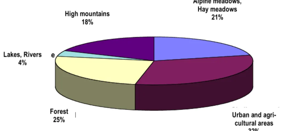
The problem of land scarcity is intensified by the fact that not all areas are equally well suited for human use. Häberli et al. (1991, p. 12ff) noted that the actual economic life of Switzerland is limited to only a third of the country's territory (Fig. 3). This is mainly because of the topography. A strong slope can make the use of an area technically impossible. The flat lands, which are suitable for an intensive use, are limited to the Central Plateau and the bot- toms of alpine valleys. There, productive agriculture, industry, transport and urban areas are concentrated.
Fig. 3 The land use in Switzerland (Häberli et al. 1991, S. 12)
Another natural location factor which determines land use, is the potential of an area. The presence of mineral resources (in Switzerland are gravel, sand and clay), the suitability for agricultural crops, and the exposure and location can predict land use.
Infrastructure facilities represent a key anthropogenic location factor, which determines the spatial distribution of commercial land use (Nowotny 1971, S. 18ff). The development of transport networks around economic centers leads, in most cases, to the extension of resi- dential areas in the neighboring communities because more people, who work in the city are drawn to live in the countryside. According to the data from the 2000 census about 74% of the Swiss population live now in urban areas. In some cases, infrastructure investments ac- tually allow the exploitation of the actual surface potential. For instance, the agricultural pro-
Hochgebirge 18%
Seen, Flüsse 4%
Wald 25%
Siedlungs- und Landwirtschaftsge-
biete 32%
Alpweiden, Heuwiesen
21%
High mountains 18%
Lakes, Rivers 4%
Forest 25%
Alpine meadows, Hay meadows
21%
Urban and agri- cultural areas
32%
8
ductivity of the peat soils, rich in nutrients, could only be exploited after their drainage. Hence the name "soil improvement" or "melioration" for agricultural engineering measures. Famous examples of large area drainages are the Linth correction (1807-1816), the first Jura water courses correction (1868-1891), the second Jura water courses correction (1962-1973) and the correction of the Alpine Rhine in the Rhine Valley in St. Gallen (late 18th century to pre- sent).
An agglomeration effect of economic centers that is crucial for the use of land in a region is the creation of specific markets. The urban agriculture produces mostly vegetables and fruit, i.e. fresh products that reach consumers directly, without further processing. Conversely, certain crops are cultivated on a wide territory because of single processing plants of agricul- tural products. Since the products in general must be processed while fresh (such as canned fruit, sugar beet), the spatial extent of suppliers is primarily restricted by the required trans- portation time. In the case of Hero Lenzburg AG and Hilcona AG, Schaan (FL), cultivation contracts for fresh products were made with farmers in a radius of 60 to 120 km (Mr. Gal- mann, purchaser at Hero Lenzburg AG, personal communication of March, 16th 2000).
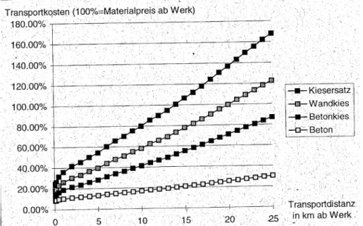
Fig. 4 Impact of transport costs on the material costs of different qualities of gravel de- pending on the transportation costs (Binswanger und Siegenthaler 1995, p. 424) Transport costs also limit the sales area in the gravel market (Fig. 4). Consequently, the gravel market has a very important region-specific relevance. The sale prices within a gravel region can be determined regardless of the global market. In addition, there are often cartel- type associations within a region, which determine the price. Because of the distance protec- tion and antitrust agreements, many relatively small and medium-sized enterprises can still be found in the gravel economy (Binswanger und Siegenthaler 1995).
Land use can significantly affect natural resources. It can permanently change the character- istics of the environmental systems. These changes can be evaluated positively or nega- tively, depending on whether they are considered from the perspective of humans or from the environmental resources point of view. In recent decades however, in many cases it was observed that to a certain extent, positive effects of land use can also turn into negative. Pre- cisely this turn of positives to negatives is to be avoided in the sense of sustainable resource management.
Since the mid-20th Century the negative effects of agglomerations are more significant. Ur- ban agglomerations are characterized by the lack of natural resources, in particular soil space, natural habitats and recreation areas, as well as to some extent (ground) water. Thus,
9 the land use conflicts within in a region intensify. In addition there is the impact on environ- mental resources by the different types of land use; on the one hand with waste released into the air, water or soil, on the other hand by the over exploitation.
Although it is undisputed that contrary measures must be taken against the negative urban agglomeration effects, the economic use of resources must be furthermore guaranteed.
Thus, the Swiss country prescribes a balanced proportion between the protection and utiliza- tion of natural resources (Art. 73 BV). The Federal Act on Agriculture (Landwirtschaftsgesetz) (Art. 1 LWG), the Forest Act (Waldgesetz) (Art. 1 WaG) and Water Protection Act (Gewäss- erschutzgesetz) (Art. 1 GSchG) highlight in the purpose articles the multi-functionality of the type of use; that means, the protection of resources is basically to be integrated in the use. Also after the precautionary principle of the Environmental Protection Act (Um- weltschutzgesetzes) (Art. 1 Abs. 2 USG) the prevention of environmental damage preceeds the restoration. The statutory assignment for the spatial balance between protection and use of resources is given by the Land Use Planning Act (Raumplanungsgesetz) (Art. 1 RPG).
The implementation of the statutory mandate for the sustainable use of environmental re- sources in a particular case requires appropriate measures from all disciplines that deal with the various resources, as well as a smooth cooperation at the interfaces (Fig. 5). Thus the decision-making for the optimal allocation of the land use is a very complex problem.
Within this lecture, the fundamental bases for the decision-making will be discussed.
Luft Wasser
Boden
Fläche Landschaft
Rohstoffe
Energie Ökosystem Grundlage für Primärproduktion Landschaftsschutz
Raumplanung
Forstwirtschaft
Landwirtschaft Naturschutz Bodenschutz
Luftreinhaltung
Wasserbau
Gewässerschutz
Fig. 5 The various disciplines, that regulate the management of environmental re- sources
10
2. I
NTERVENTION IN THE WATER REGIME OF A TERRITORYThe interventions in the landscape water regime are controversial agricultural measures be- cause they affect in most cases a wide area, that is, they have an impact on hydrological catchment areas. These are the irrigation and drainage of soils, and the regulation of water bodies that serve as collectors of water. In humid climate areas, such as large parts of Cen- tral Europe, the irrigation of soils plays a subordinate role, whereas the drainage is a more important issue.
2.1 Soil Drainage Purpose
The main objectives of soil drainage are the improvement of the soil, air and water re- gime, for the contemplated agricultural crops, particularly the elimination of water logging in the soil. The main effect of drainage is the increase of the distance between soil surface and groundwater, so that the layer of the soil occupied by the roots is not permanently saturated with water. Information on the root depth of different crops, and the optimal distance to groundwater can be found in Muth (1991, p. 58f). Especially in the first half of the 20th Cen- tury the conversion of grassland into arable land was one of the main reasons for soil drain- age. The lowering of groundwater levels resulted primarily in an improved aeration of the root area, which contributed significantly to the safeguarding and to some extent to the increase in yields. Due to the improvement in air provision, the soil in the root area has a faster and more frequent increase in water potential. This increases the mechanical stability of the soil, which means that over the year, the soil can be more frequently worked on and driven over.
Moreover, due to the improved oxygen supply, the biological activity of soil organisms also increases. The increased demand for nutrients is covered by the decomposition of soil hu- mus. Through the decomposition of soil humus the nutrients in the soil are mineralized, which mainly results in a strong increase in the amount of nitrogen available for plants (Blume 1992, p. 229). The higher the content of organic matter in the soil, the more nutrients can be released through drainage. For this reason the peat containing, rich in humus swamp soils were considered as particularly fertile soils, which was the reason to drain large swamps (e.g. Grosses Moos in the Canton of Bern and other examples already mentioned in section 1.3).
The causes of water logging in soils are essential for the choice of suitable drainage proce- dures. In Central Europe the following water logging causes are known:
• high groundwater level
• compaction
• lateral flow (local sources or inflows)
• residual water.
The goal of classical peat drainage was the lowering of groundwater levels. As the peat soils are usually well permeable, the drains were very successful. However, the organic mat- ter decomposes very quickly because of air supply, so those soils can lose up to 2 cm of altitude per year (Kuntze et al. 1994, S. 334, Blume 1992, S. 229). This leads to soil subsi- dence in large areas. Thus, the drain facilities are located closer to the soil surface, and may be damaged by the plough. Because the thickness of the peat layer is usually not the same over an entire drainage area, there are spatial differences in the subsidence. This may entail counter slope, or even failure of drainage pipes. In these cases the drainage effect, at least locally, no longer exists. Today, the question of restoration arises for many old drainage ar- eas. Preserving the cultivation possibilities of the areas requires the removement of high-
11 lying pipes and the replacement with new, deeper ones. This process can be repeated until the pipes reach the impervious layer, which actually enabled the formation of the peat bog.
After this however, it can be said that the peat bog has, in the truest sense of the word "run down". The humus has been consumed and it will not renew itself even in a geological pe- riod. For this reason, the peat soil management in Holland, North Germany, as well as by the lakes in Switzerland where they have been wide spread, cannot be described as a sus- tainable form of land use.
In addition, the repeated lowering of the drainage facilities entails a deeper channel for the receiving waters to avoid the drainage pipes lying below the water table of the receiving wa- ters. Otherwise, the drainage pipes would be flooded. If the deepening of the channel is no longer possible, the drainage water has to be pumped to the higher water level in the chan- nel.
Compaction can have both natural and anthropogenic causes. The water is accumulated over an impermeable layer and generally has no contact with ground water. Every abrupt change in grain size or soil structure that causes a great difference between the pore diame- ters of the upper and lower layer acts as an impervious horizon. In nature, clay- or gravel pockets, or structure changes caused by tillage and cultivation (see section 3.1), constitute the impervious layers. Water logging can occur very locally, like in a hollow where the soil water of a whole area is collected, or at heavily wheeled places such as field edges and field access roads. In particular, compaction and water logging is the main problem on restored soils (see section 4.2).
Lateral flow is caused by external inflows. In most cases they arise more or less locally at the base of a slope or beside roads, buildings or movements of terrain. In general, this lateral water can be deviated with one or a few capture drains, without setting up an extensive installation.
Residual water occurs especially in silty and clay soils. Anthropogenic soil compaction or structure disruption can facilitate residual water. Soils with residual water are very difficult to drain because of their fine grain components and dense stratification. The water is bound with very high capillary forces (water potential).
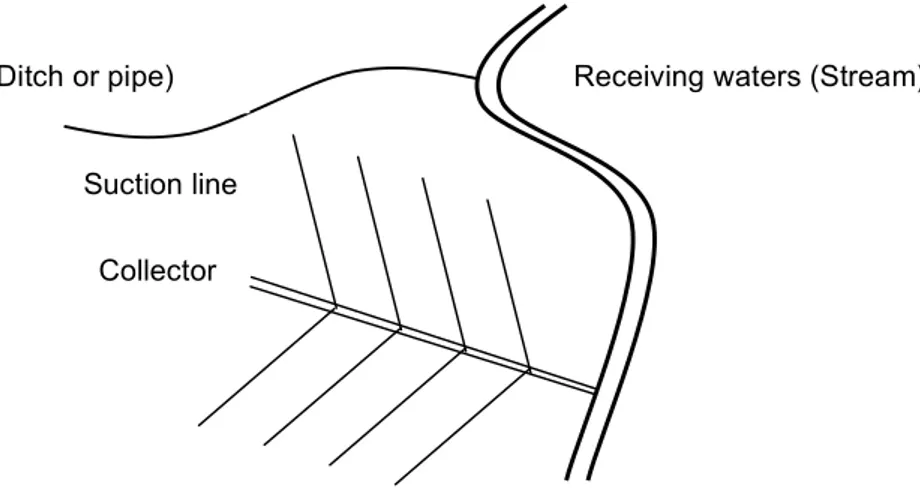
Technical Requirements
Fig. 6 Schematic representation of a drainage perimeter Capture drain (Ditch or pipe)
Suction line Collector
Receiving waters (Stream)
12
A drainage system consists of suction lines, collectors and the receiving waters (see Fig. 6).
The suction lines take the water from the soil and pass it further into the collectors which lead the flow into the receiving waters. On the edge of a drainage perimeter, capture drains are installed depending on the lateral flow.
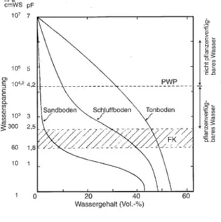
Drainage systems work after the gravitational principle. Thus, they can only drain water, which can move freely out of the soil, i.e. water that is bound with a capillary suction of less than 6 kPa (pF = 1.8) (Fig. 7). In other words, it can only be drained until field capacity. The field capacity is conventionally defined as the water content of a soil two to three days after having reached full saturation. This is the main reason why soils with residual water cannot be drained.
Fig. 7 Water potential curves of different soils (cmWS = Centimeter Water column (equivalent to 0.1 kPa); FK = Field capacity; PWP = Permanent Wilting Point) (Scheffer und Schachtschabel 1998, S.189)
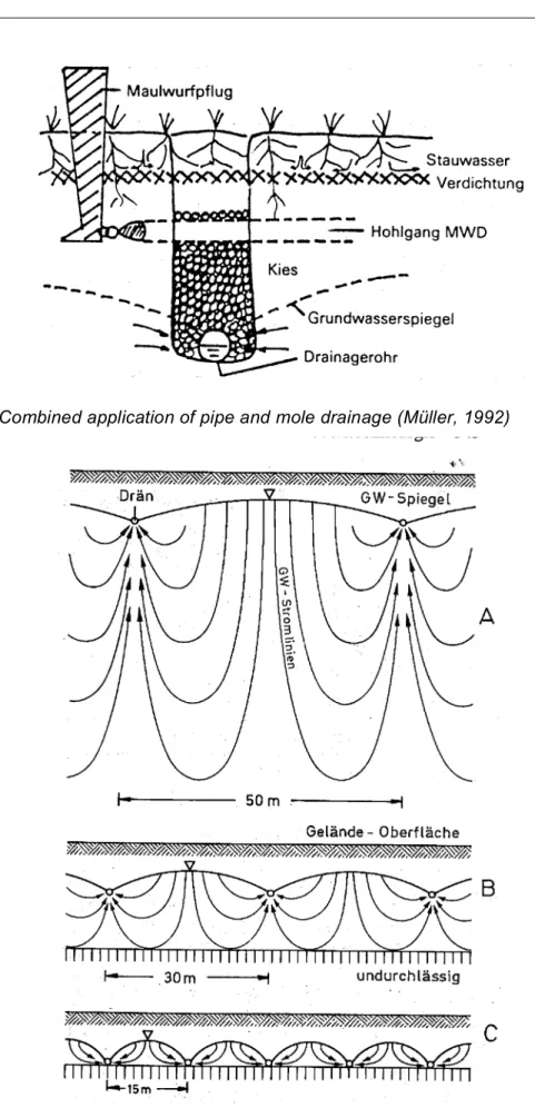
The technical implementation of drainage facilities is done either with open drainage ditches or with underground pipes, gravel packs, or so-called earth or mole drains. Rectan- gular networks with straight drainage ditches dominate many landscapes of Switzerland (e.g. the Linth plateau). Since open ditches interfere with the agricultural management, they are usually only laid out in large intervals as receivers for the underground drainage. They must often be deepened in the course of drainage renovations, because the drainage in the surrounding soils is lowered. Earlier, drainage pipes were made out of clay tubes placed one after the other with several mm distance between them. Today perforated PVC-tubes are used as a rule. An alternative are gravel slots, which are covered with humus. On soil restorations, linear gravel packs are sometimes laid out prior to the filling on the restoration plane (land restoration, see section 4.2).
For mole drainage a specially shaped pressing head is pulled through the ground, forming canals in this way. This technique can only be applyed in soils containing clay, without coarse stones. Otherwise, the created vault is not stable due to the lack of cohesion. The advantage of the mole drainage is that this technique can be executed by the farmer with his own tractor because of the relatively low tensile force required. For technical details about the installation of drainage facilities refer to Muth (1991, p. 74-79).
13 Fig. 8 Combined application of pipe and mole drainage (Müller, 1992)
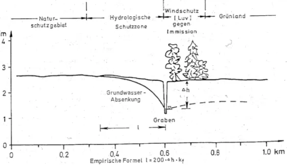
Fig. 9 Flow of water to the drain pipe, depending on the depth of the impermeable layer (A>B>C) (Kuntze et al. 1994, p. 345)
14
For the influx of ground water into the drainage pipes as well as for the necessary spacing between drainages, the depth, at which the impervious layer is located, is crucial (see Fig. 9).
The nearer the drainage lines are to the impervious layer, the shorter the infiltration ways.
This means, the faster drainage is accomplished, but the smaller the spacing between the drainage lines has to be, too.
There are different approaches to calculate the influx to a drain. They are derived and ex- plained in Ritzema (1994, p. 263-304). As example the equation of Hooghoudt is derived below.
Hooghoudt - Equation Assumptions
• Drain pipes run parallel; (ii) Stationary flow condition (infiltration rates and water contents are constant in time); (iii) two-dimensional water flow in a plane rectangular to the drain- age pipes.
Calculation approach
The groundwater flow is formulated through a vertical section at a distance x from a ditch, so we get after the Darcy-law:
qx =Ky x( )dy
dx (1)
where: qx flow rate in x-direction K Water conductivity
y(x) Groundwater level at location x
dy/dx Hydraulic gradient
From the assumption that a steady flow has developed, follows:
qx=R 1 2L!x
"
# $
%
(2) where: R = Infiltration Rate
L = Drainage distance;
Then (1) is replaced in (2), and follows:
Ky x( )dy=R 1 2L!x
"
# $
% dx (3)
The integration of equation (3) with the following conditions:
with x = 0 ; y = D with x = 0.5L ; y = H Results in the equation (4):
q=R= 4K H
(
2!D2)
L2 (4)
15 Fig. 10 Horizontal flow conditions in a drainage over an impermeable layer
(Ritzema, 1994).
In Fig. 10 it can be seen, that H-D=h and H+D=2D+h. The height h in the Fig. repre- sents the difference between the ground water level and the drain water level. Simi- larly equation (4) can be rewritten to:
q=8KDh+4Kh2
L2 (5)
This equation (5) is known as the Hooghoudt- or the Donnan-equation. If the drainage is directly on the impermeable layer, then D = 0, and the equation is reduced to equation (5):
q=4Kh2 L2
(6)
In this case, the groundwater flow occurs above the drains into the ditches. In the case D>>h, that is, the impermeable layer is very low, then the second term of (5) can be neglected and the result is:
q=8KDh
L2 (7)
Here, the greatest part of the water flows to the ditch below the drainage level. In some cases, the drain pipes lie on or near a boundary between two layers of materi- als with different permeability. This circumstance can be taken into consideration when using the equation (6) and (7). It can accordingly be seen in the Hooghoudt- equation:
q=8K2Dh+4K1h2
L2 (8)
In it, K1 is the conductivity of the upper and K2, the conductivity of the lower layer. As Fig. 9 shows, the groundwater inflow into a tube-shaped drainage is not the same as in the case of drainage ditches. In the surroundings of the drainage lines there is a contraction of the stream-lines and a radial deformation of the flow field. Hooghoudt considered these radial flow losses to a drain-pipe in decreasing the layer thickness D. In equation (5), this approach means that instead of D, the reduced value d is used. The distance d is also called equivalent value. Correspondingly, equation (5) is transformed into:
q=8K2dh+4K1h2
L2 (9)
The equivalent value d depends on the drainage distance L, the layer thickness D and the radius of the drainage pipe r0. Hooghoudt developed several nomograms to
16
derive the amount of d. In order to apply the approach of Hooghoudt in calculation models, the following function for calculating the equivalent value was developed:
d=
!L 8 ln L
!r0
"
#
$ %
&
' +F x( )
(10)
In equation (7) x is defined as follows:
x=2!D
L (11)
as well as:
F x( )= !
2
4x+ln x 2!
"
# $
% for x≤0.5 (12)
F x( )= 4e!2nx n
(
1!e!2nx)
n=1
"
#
for x>0.5 and with n= 1,3,5.... (13)Restoration of wetlands
For the restoration of wetland habitats, large quantities of water must be available through- out the year. Therefore, in the first place it must be ensured that rain water is not removed.
Existing drainage systems are to interrupt or flood. For this reason, the renaturation of wet- lands is often realized as an alternative to the restoration of deteriorated drainage systems.
In rare cases, intact drainage systems are actively flooded (e.g. land improvement Kloten).
In addition, there must be an impervious layer available. This can be either the natural re- tainer which caused the original wetland, or an artificial sealant. The latter can be accom- plished, for example, with the deposition of sludge from gravel washing (see section 4.4).
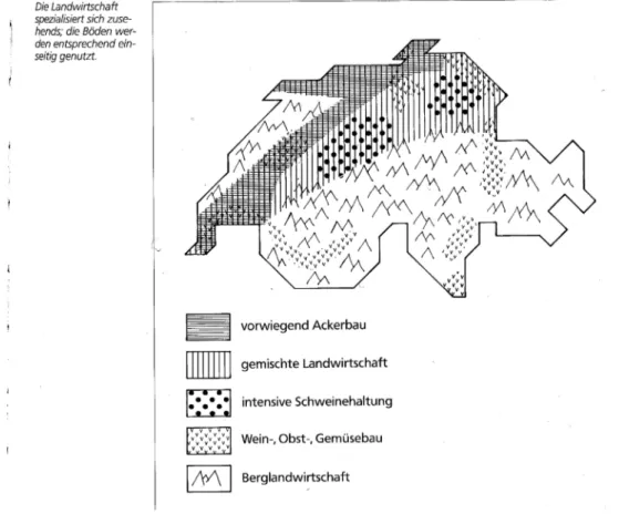
Fig. 11 Establishment of hydrological and immission protection areas around renatural- ized wetlands (Blume 1992, S. 691)
17 Further, the groundwater levels in the wetland must be raised again in relation to the sur- rounding (agriculturally used) area. This entails the need for a hydrological protection zone between the actual wetland and the surrounding agricultural zone (see Fig. 11).
Equally important is the prevention of the entry of nutrients in renaturalized wetlands.
Against pollution from the air, a vegetation windshield is recommended at the weather-side of the main wind direction. If wetlands are fed from the groundwater in the surroundings, stripes of filtering vegetation are to be established to protect the wetland from nutrients in the groundwater (see. section 3.3 Fertilization and pest management). In individual cases, where the required space for the establishment of hydrological (pollution) protection zones is not available, the groundwater regime of the wetland can be isolated using sheet pilings towards the surrounding. The supply of uncontaminated water in the habitat must then also be artifi- cially ensured (for example with pumps).
Basically, it should be noted that a restoration shows success only after a very long time (decades to centuries). The recuperation of peat bogs is only successful in the presence of a peat layer (rescue of the remaining peat layer). The regeneration of the peat will take several thousand years (Klötzli 1991). In severely decomposed peats, the nutrient supply is so high that the original meager state of the habitat can not be reached by a new water logging alone. In practice, in such cases the nutrient-rich topsoil is removed (e.g. peat bog of Stein- maur, land improvement in Kloten, both in Canton Zürich). But also in less extreme cases, for example in the conversion of nutrient-rich meadows in less nutrient-rich levels such as ar- rhenaterion (Frommentalwiese), the occurring nutrients must always be removed again (har- vested). Nevertheless, even in these cases a conversion requires decades. Considering the fertilizer from the air (see section 3.3) the actual restoration to the original condition is un- likely.
2.2 Irrigation Objective
In arid climate areas, irrigation is often a necessary condition for the cultivation of agricul- tural crops. In our latitudes, usually irrigation takes place only temporarily at certain times of the growing season, which is when the crops need more water for their growth than there is available from the soil water supplies. For this reason, especially sandy soils, which present low water storage capabilities, are often irrigated. This allows, in particular with vegetables, to significantly increase the yields. Another reason for irrigation in areas with humid climate is the antifreeze irrigation as protection for flowers or buds against late frosts in the spring (and respectively, to protect the young plants against early frosts in autumn).
Technical Requirements
There are various irrigation techniques; from flood irrigation, and underground water inflow with drain like channels, to aspersion with sprinklers. The procedures are describes in detail by Muth (1991, p. 207-270). In industrialized countries it is mainly irrigated with sprinklers, because this is most similar to the natural rainfall. The antifreeze irrigation in particular, is only possible through sprinkling, so that the water supplied can freeze around the sensitive parts of the plant like an ice mantle. When the water is freezing, condensation heat is re- leased which is enough to prevent the cell liquid to cool down below its freezing point (-0.5 ° C) (Muth 1991, p. 267). However, it must be irrigated during the entire period of frost (e.g. the whole night until sunrise) so that the heat supply is not interrupted.
18
Even with a careful implementation of the irrigation, the supplied water is never fully available for the plants. The excess of water must be drained back to prevent damages resulting from water logging. Consequently, every irrigation needs a drainage system.
In silty soils, potent sprinkler equipment may cause the soil sealing on the soil surface (see also section 3.2 Erosion) (Blume 1992, p. 233). Likewise, barely permeable soils should not be irrigated, as they naturally tend to water logging. If the water retention capacity of a soil is extremely small (pure sands), the irrigation can be very inefficient (Muth 1991, p. 208).
In arid climates, the salinisation of the soil is one of the most important problems caused by irrigation. In dry periods, the salts from the groundwater ascent by capillarity and are transported to higher soil layers, where they crystallize and concentrate. Because the ground water level is increased in many cases due to irrigation, the capillary water rises more fre- quently up to the root horizon. In particular, a high concentration of sodium ions is problem- atic, because sodium ions possess high hydration energy. Due to the small radius of the ions, the positive charge concentrates on a small surface. The bipolar water molecules are more attracted, so that a water jacket accumulates around the sodium ions. This increases the osmotic potential of the ground water, making it less available for plants, because the water absorption of plants is largely regulated by the osmotic pressure (passive absorption).
In addition, soil structure is disturbed. Because the sodium is located between the clay parti- cles, water adsorption leads to swelling, and finally to the dispersion of the clay particles.
Salinisation finally results in almost impermeable and mechanically not resistive soils.
19
3.
INTENSIFICATION OF THE AGRICULTURAL LAND USEIn industrialized countries, the primary production, where agriculture and forestry are in- cluded, showed a massive decline in the manpower in contrast to the industrial and service sector in the 20th Century. In Switzerland, the number of people employed in agriculture de- clined from 1950 to 1991 by more than 50% (Häberli et al. 1991, p. 86). In the former Federal Republic of Germany, the permanent manpower employed in agriculture decreased from 5.87 Mio (1949) to 1.308 Mio (1993). In the process, a gradual transformation took place, from full time employment to a part-time occupation and finally to entire retreat from farming.
In Switzerland, the number of full-time farmers declined from 177412 to 62804, i.e. by more than half, in the period between 1939 and 1990. The part-time farms developed in the same period from 61069 to 45492, which means they decreased by about 25% (Baur 2000). In the old Federal Republic, between 1979 and 1991, around 11.1% of the farmers switched from full time to part-time work, and during the same period 21.6% of the part-time farmers aban- doned the farming activity completely. Conversely, the sizes of the farms increased (Deutsches Institut für Fernstudienforschung Uni Tübingen 1997, p. 204f).
This shift in the employment situation is both a consequence of industrialization (which led to the increase in the proportion of part-time farmers), and of the technological progress in agri- culture itself. The latter enables the efficient management of the soil, without which agricul- ture would no longer be viable. As a result, agriculture increasingly specializes by regions;
the soils of each region are progressively used in a one-sided way (Fig. 12)
Fig. 12 The specialization of Swiss agriculture in different geographical units (Häberli et al. 1991, p. 89)
20
3.1 Mechanical Impacts, Soil compaction Mechanical properties of the soil
Each soil has its own degree of inherent stability, which results essentially from the contact between the soil particles. The denser a soil is, that is, the more and the bigger the contact surfaces are with adjacent soil particles, the higher the pressures (or tensions) that must be applied to separate the particles from each other or even to move them closer together. In soil mechanics, the stability of the soil is described with the shear strength, and the pre- compression stress (more details in Hartge and Horn 1991, p. 55-80, and Kézdi 1969, p.
169-206).
G Ft
!v
"f v
Lastfall Befahrung
Fig. 13 Schematic representation of the strain condition in the soil with a load passing over. G: Wheel load, σv: Precompression stress value, τf: Shear strength
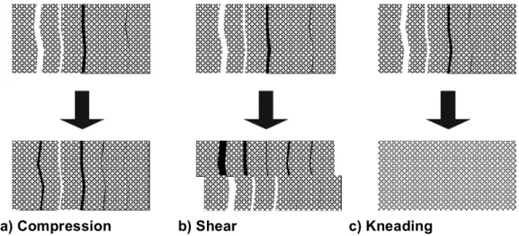
a) Compression b) Shear c) Kneading
Fig. 14 a) Compression: compression leads to the destruction of coarse pores. This decreases the total pore volume; however the relative proportion of medium and fine pores can be increased.
b) Shear: shear does not lead to increased bulk density in every case. The soil pores, however, are sheared off and subsequently no longer continuous.
c) Kneading: Kneading means the destruction of the secondary structure. The transition to coherent or single grain structure (primary structure) is referred to as homogenization.
(Source: Tobias et al., 1999b, p. 23)
Load case – wheeling
21 Fig. 13 explains the situation of the loading case in a wheeling. A wheel acts perpendicular to the ground with its wheel load G. A soil particle at a certain depth experiences the (partially decomposed, see below) stresses and acts against them with its own stability. The maximum axial stress that the soil particles can raise corresponds with their precompression stress σv. The maximum shear stress, with which it can counteract the strain, corresponds to the shear strength τf. If the wheel load exceeds the inherent stability of the soil (σv or τf), there will be a permanent deformation or failure. The soil is compressed (exceedance of σv) or the particles are sheared apart (exceedance of τf). Close to the wheel, the soil structure is kneaded, i.e. it is homogenized. The soil aggregates are destroyed, the soil structure becomes single grained or coherent micro-structure. Fig. 14 provides a schematic overview of the different mechanisms.
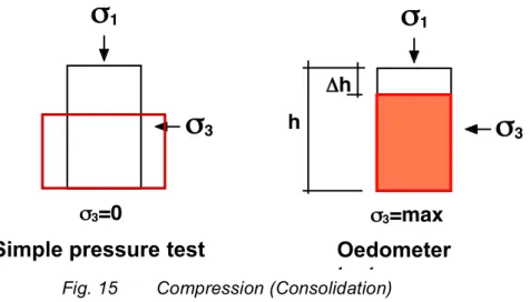
Compression / precompression stress
If a soil cylinder is compressed, it will deform. If it is not fixed at its sides (as in the so-called simple pressure test) it expands to the sides, without greatly reducing its initial volume. In nature, i.e. in the soil (as in the Oedometer experiment), the lateral expansion of the cylinder considered is impeded. The soil core can only deform in vertical direction, resulting in the reduction of the volume (Fig. 15).
!
1!
3!
1!
3"h h
!3=0
einfacher Druckversuch Oedometerversuch
!3=max
Fig. 15 Compression (Consolidation)
This deformation is elastic, i.e. reversible, as long as the pre-compression stress of the soil is not exceeded. Exceeding this pre-compression stress will result in a plastic, permanent deformation. The pre-compression stress is determined from the Oedometer test. The results of the Oedometer test are represented in the consolidation curve, which shows the (linear) volume decrease ε, as a function of the common logarithm (log) of the applied compressive stress (Fig. 16). The half logarithmic representation of the consolidation curve enables the distinction between a stress range of elastic deformation (re-load curve), and a stress range of plastic deformation (virgin compression line). The log of the pre-compression stress corre- sponds to the value on the x-axis in the strongest curvature of the consolidation curve.
Simple pressure test Oedometer
test
22
log !
" =#h/h
log !
vWiederbelastungs
bereich Erstbelastungs
bereich
Fig. 16 Consolidation curve
Shear
Shear means the displacement of soil particles against each other. Depending on the ar- rangement of the soil particles there will be a compaction (volume reduction), or a loosening (volume increase) (Fig. 17). In the process, thrusts are effective, which exceed the shear strength (τf) of the soil.
!
1!
3"
fF
F
Verdichtung
Lockerung
Fig. 17 Shear
The shear strength is determined by shear tests (tri-axial or direct shear tests). The stresses in the failure state are represented in the stress-strain diagram of Mohr. Fig. 18 shows various breaking conditions for the same soil. The shear strength τf is the maximum value of the thrust in the failure area. This shear strength is defined by the function of the envelope of all failure circles (called Mohr's failure curve). Within the applicable tension range for the concrete problem, Mohr's failure curve can be approximated with a line. This is known as Coulomb's failure line and is defined by the following equation:
τf = c + σtgϕ
σtgϕ is the slope of the failure line and c the ordinate section. ϕ is usually called angle of internal friction and c cohesion.
Compaction
Loosening
23
!
f"
"
1"
3!
fFig. 18 Mohr’s circles, Shear strength value (τf)
Pre-compression stress and shear strength values are strongly correlated; therefore, both failure mechanisms occur at the same time, but in locally different zones. Moreover, the two parameters depend strongly on the soil water potential, as the capillary tensions "pull" the particles closer together, resulting in an increase of the number of contact points. Pre- compression stress and shear strength are therefore not constants, but state values, which heavily depend on soil moisture. Basically, the inherent stability of a soil increases as the humidity content decreases.
Causes
The need of the individual steps in agricultural cultivation arises from the choice of crop rota- tion. Grassland ploughing goes in advance of the cultivation of field crops and is repeated periodically in crop rotations with artificial meadows or green fallow land. Ploughing serves to transport harvest residues or organic fertilizer in the root horizon, on the one hand, and in- creases the nutrient supply for the subsequent crop. On the other hand, it allows to mechani- cally combating weeds. The soil structure is brought to a state, which allows the optimal growth of the desired crop. The objectives of the various procedures and the agricultural equipment used for these purposes can be seen in Table 1. Besides the actual soil cultiva- tion, the wheeling of agricultural vehicles, spreading fertilizers or pesticides or collecting the harvest, has an essential impact. In this sense, attention has to be paid on the multiple cuts of grassland within the vegetation period.
The choice of the different crops is crucial, because, as already said, this determines the necessary procedures for the crop management, as well as the timing for the cultivation of the soil (Fig. 19). Especially problematic is where farmers commit with processing plants (such as canning factories) through cultivation contracts, which bind them to deliver their harvest in large quantities at certain dates. In case the agreed dates are in a period of bad weather, the farmers have no possibility to delay their harvest due to the reduced bearing capacity of the soil. In addition, due to the mass production the harvest must be accom- plished with very powerful machines (see Section 1.3).
Agricultural soil cultivation primarily consists of loosening the soil structure by breaking up the aggregate composites (ploughs, cultivators, spade machine), or crushing the aggre- gates themselves (power driven milling machines and harrows). As a result, the pre- compression stress and the shear strength of the soil are greatly reduced, which means the soil is wheeled in a state with a low bearing capacity. Any further loading supports the ho- mogenization and compaction of the soil structure. Generally, agricultural soils must be com- pacted artificially with rollers or packers after loosening, because the roots of only very few crops (such as potatoes) can hold in extremely loose substrates.
24
Tab. 1 Major objectives of various agricultural cultivation measures (Blume 1992, p. 156)
Particularly adverse is the impact of wheeling or cultivating moist and wet soils. In this state, the soil generally has a low precompression stress and shear strength, which lead to important plastic (irreversible) deformations and kneading during loading and manipulation.
For Swiss climate and soil conditions (usually high amount of rainfall and fine-grained soils) the cultivation of root crops (potatoes, corn, sugar beet) is conceivably inappropriate. Be- cause of their long growing season, these require a seed bed preparation in early spring with full soil water storage, and harvest in late fall with increased soil moisture due to lower evapotranspiration. The central point here is to choose a crop rotation, which is appropri- ate to the local climatic and soil conditions. But even with cereal dominated crop rotation, the time for land cultivation can still be optimized in regard to soil protection . So it is recom- mended to accomplish as many working steps as possible in autumn, when the soil water storage is largely consumed.
The biggest problems appear in soils with a sensitive structure. The most unstable struc- ture is featured in fine-grained, not cohesive soils (i.e. not containing clay). These show the lowest shear resistance at all moisture contents when compared with differently granulated soils. Silt and fine sand are the most at risk of structural damage. In addition, a surplus of sodium ions compared with calcium ions is very unfavorable. Soils with a high Ca++-content feature a much more stable micro-structure than soils in which Na+ prevails (see section 2.2).
Therefore, hazardous soil compaction conditions appear especially with:
• intense loosening (destroyed micro structure, reduced precompression stress)
• high soil moisture (reduced shear strength)
25
• fine-grained, not cohesive soils (silt soils: low shear strength due to the lack of genuine cohesion)
• unfavorable cation adsorption of clay minerals (Na-soils instead of higher Ca-saturation).
Fig. 19 Example of a functional chain of soil compaction
The extent of soil compaction does not only depend on the structural sensitivity of the soil itself, but also largely on the management technique. A high contact pressure at the soil surface leads to high tensions and consequently strong compaction and kneading directly below the contact area. Since 1950, the weight of agricultural vehicles and machinery has massively increased with the increased power (see Fig. 20). The pressure in the contact area of the equipment can be maintained or even partially reduced by increasing the contact ar- eas, for example with twin or extra wide tires. The increase of the contact area, however, leads to deeper compaction, as the pressure spreads under the contact surface in a bulb- shape (see Fig. 21). The wheeling and cultivation of the soil with heavy machinery lead to compaction of the sub-soil, which is very serious, as the farmer can hardly correct it with his available equipment.
Example of a functional chain of soil compaction
26
Fig. 20 Bandwidth of the allowed overall mass for agricultural vehicle types offered in the Federal Republic of Germany (Sommer and Hartge 1991, p. 107)
Fig. 21 Pressure bulbs for three different tracks (Sommer and Hartge 1991, p. 108)
The type and frequency of the passes also have a large influence on the damage patterns and their extent. Fig. 22 illustrates the effects on the soil when ploughing. While the topsoil is loosened (along with a reduction in pre-compression stress and shear strength), the subsoil is heavily compacted by the tractor wheel traveling along in the plough furrow. This technique leads to the widespread appearance of the plough sole. The simplest and most effective measure to prevent the plough sole is the avoidance of driving in the plough furrow. Some farmers already apply so-called Onland- (or offset-) ploughs, which allow the tractor to drive over the unploughed soil with all four wheels (Fig.23).
27 Fig. 22 Change of the pre-compression stress with the ploughing activity (Semmel and
Horn 1994, p. 45)
Fig. 23 Location of the charge points of the pulling force with Onland (or offset) ploughs
Top: “Pulling point in the middle”: The pulling point (ZP1) is centered, the tractor drives with a slight side pull (Sz1), because the pulling line does not run through the rear axle (M). The inclined pull line (ZL1) leads to an increased pressure from the plough at- tachments against the furrow wall (A), which increases the tensile force requirements.
Below: “Pulling point ploughed”: The pulling line (ZL2) is straight, the required pulling force is therefore reduced. The side pull is greater, because the pull line (ZL2) runs away further from the middle of the rear axle (M). (Anken 1996, p. 6)
Multiple passes on the same areas lead to the expansion of compaction zones in the depth. Compacted horizons react to stresses as rigid plates, they handle the tension without significant further reduction in layers, which can absorb the tension while deforming, which means, also being compacted. Finally, the slip of the driving wheels also contributes to dam- age on the soil structure, because it causes the kneading of the soil. Slip originates in low
28
tensile force, especially in wet soils. Power driven devices greatly reduce the slip as the en- ergy for manipulating the soil must not originate only in the towing vehicle. However, the power driven machinery destroys the aggregates more, which in turn supports the homog- enization of the soil.
Ecological consequences of soil compaction
Soil compaction takes place primarily at the expense of coarse pores, where the proportion of fine pores increases. Also, the middle sized pores decrease except for coarse sands. Fur- thermore, by moving the soil particles against each other, the continuity of the pores is inter- rupted. Consequently, the water and air balance of the soil changes. The gas exchange with the atmosphere is strongly obstructed, not only in volume due to the loss of coarse pores, but also the diffusion is severely limited due to the lack of pore continuity. Below compacted ho- rizons the oxygen diffusion can decline so much that anaerobe and reducing conditions arise. The infiltration capacity of a compacted soil is strongly diminished, resulting in in- creased surface runoff. At the same time, a compacted soil can drain less rapidly, what en- tails water logging.
Through the loss of air filled pores, the effective heat capacity and conductivity increase.
Consequently, compacted soils heat up slower and also cool down at a slower pace, so that the loosening effect of frost hardly occurs.
Also the nutrient balance is affected. Manganese, iron and sulfur are reduced under an- aerobic conditions, and thus less available for plants. Nitrate can be reduced to elemental nitrogen (de-nitrification), which then escapes to the atmosphere.
Compactions restrict the root space, as compacted horizons present a much higher penetra- tion resistance for the roots. Dense clods or aggregates are not penetrated by the roots, but surrounded by them. Consequently, in compacted soils the roots grow mainly along cracks.
The nutrient and water resources stored in the clods can hardly be accessed. Finally, (sugar) beets change in compacted soils their growth habit. They develop several peaks that break easily at the harvest and lead to yield losses.
Remediation of soil compactions
The remediation of compacted soils involves two aspects: first, the loosening of compacted horizons; second, the stabilization of the loosened micro structure. The actual land improve- ment interventions are usually of relative short duration compared with the time needed for such a strongly loosened structure to find a new equilibrium with natural consolidation and the re-emerging of biological activity (Horn et al. 1995). For the remediation of soil compac- tion, the protective subsequent use after the technical intervention should also be encoun- tered. That means, agricultural use of the soil is not possible to the usual extent for several years. Soil preparation and driving maneuvers are to be reduced to an absolute minimum (e.g. extensive grassland with a maximum of one cut per year). Grazing is excluded. If after- wards, the loosened soil is not appropriately managed in a careful way, there is a risk of re- newed compaction damage, which can have a far greater extent than the original. But the technical remediation measures are very expensive and extensive subsequent use yields only little revenue. Thus, the added value of rehabilitated land remains small over several years. This problem is again to be solved on an agro-political level. From this arises the es- sential meaning of damage prevention.
29 Loosening
The restoration by loosening to break up the compacted layers, the loosening depth is usu- ally deeper than that of ordinary agricultural cultivation. There is a distinction between re- storative cultivation (occasional deep ploughing or loosening under the crumb depth) and subsoil restoration (single intervention in a greater depth, that is 50-80 cm). The transitions are, however, continuous.
The subsoil restoration comprises basically two procedures, which principally differ in their impact: deep loosening and deep ploughing (Fig. 24). In the deep loosening, the stratifica- tion of the soil horizons is preserved. This avoids that unfavorable material (too cohesive or acidic soil material, layers rich in coarse material) from deeper layers is mixed with the top- soil. Conversely, deep ploughing breaks up the soil in great depths, and combines the hori- zons. This is recommended, if the subsoil contains physically and chemically more favorable material. Moreover, impermeable horizons are placed steeper, which increases the water permeability.
Fig. 24 Combining and loosening subsoil restoration with deep ploughing and deep loos- ening (Kuntze et al. 1994, p.352)
Underground Loosening
30
However, the success of a subsoil restoration also depends largely on the soils' properties and conditions. Soils, which tend to have fragile structures, in particular silt soils poor in clay, soils with a low content of organic substance or Na-saturated soils (see Section 2.2 Irriga- tion), are not suited to get loosened because they tend to sealing and compact even more. In addition, the soil must not be too moist. It must not be plastically deformable, and should break up in loose aggregates. The soil must be dried down to the desired manipulation depth. The working principle of different deep scrapers is shown in Fig. 25.
Fig. 25 Working principle of movable subsoil scrapers (Schulte-Karring 1976; in Kuntze et al. 1994, p. 353)
Stabilization
The soil structure artificially is stabilized with biological, mechanical and chemical additives, often in connection with a subsoil restoration.
Decomposed organic matter acts as a cementing material; it supports the formation of ag- gregates and provides the soil with additional cohesion, which increases shear strength. Or- ganic fertilizer and vegetation residues are decomposed by soil microorganisms and other animals and accumulate the organic substance in the soil.
On the other hand, organic substances resistant to degradation have hardly any effect on the formation of aggregates. They can only serve as stabilizers by filling large empty spaces and increase the proportion of coarse pores locally due to the coarser grain as the soil parti- cles. An example is the addition of plastic particles in subsoil restoration. The addition of sand leads to the same mechanical stabilizer effect, as is done in the land reclamation of peat bogs in northern Germany and Holland (Kuntze et al. 1994, p. 335).
Liming shall primarily adjust the cation occupancy of the clay minerals. The increase of Ca concentration shall promote the aggregation. Moreover, CaCO3 cements the primary parti- cles. The addition of CaO causes chemical reactions with the silicates. Calcium silicate re- sults, which has such a high bearing capacity that this technique is has been applied in road construction.
Compost from sewage sludge or domestic residues was also used for soil stabilization, es- pecially in the past. However, because of the pollutant content of the waste, this measure entailed a diffused distribution of contaminated agricultural areas (see section 4.3).