Reports
German-Israeli research on the Crusader town of Arsur and its former lordship
Hauke Kenzler and Annette Zeischka-Kenzler (kenzei@gmx.de), Institute of Prehistory, Early History and Medieval Archaeology, Department of Medieval Archaeology, University of
Tübingen, Germany
Some 15 km north of the centre of Tel Aviv/Jaffa lays the desolate Crusader Period town of Arsur on a cliff above the sea. Only a few visible relics indicate the long history of the place, which was already settled during Persian times. In Hellenistic to Roman times, it was called Apollonia, named after the god Apollo, while the Byzantines called it Sozousa, "town of the Redeemer". After the Arabian Conquest, the town reverted to the original Semitic name, so that it was called Arshaf or Arsuf. When the Franks conquered the town in 1101, they changed its name slightly to Arsur. The historical connections were obviously unknown to the Crusaders, as they repeatedly conflated Arsur with the classical Antipatris, Azotus or Dor, the location of which was unknown to them (Beyer 1950: 155).
Archaeological excavations in Israel are often motivated politically or religiously. This can be seen by the archaeological emphasis on particular periods. The entire Middle Ages and especially the more modern periods are, up to now, largely underrepresented in archaeological research. The main research interests for the Crusader Period have always been castles, fortifications and churches. In contrast, studies of towns and settlements in general still take a backseat. Recent publications on fortifications and towns in the eastern Mediterranean (e.g. Piana 2008; Wieczorek et al. 2005) accordingly rely primarily on results of field walking and architectural investigations of buildings that still stand.
One searches in vain for comprehensive and comparative studies on medieval towns and the urban development of the Crusader Period in all of its aspects, such as planning, construction and use of public and private areas, the typology of housing, technology and craftsmanship, facilities for water supply or infrastructure, etc. The rural hinterland of the Crusaders' castles and towns is treated only in a single large-scale perspective based on all of Israel by Ronnie Ellenblum (1998). A groundbreaking archaeological settlement study on the development of the landscape in the southwest of Caesarea, which also includes the natural resources, in addition to an exemplary archaeological survey and the analyses of written sources, was published by Denys Pringle as early as 1986, but remained largely unnoticed by later researchers. Thus, at the moment, the landscape archaeology of the medieval period is largely neglected in Israel. Studies on medieval “Arab villages” are almost completely missing.
This desideratum also applies to the finds material. Our knowledge of medieval ceramic in Palestine – no matter whether early Islamic, Crusader or Mamluk – is still limited. Salvage excavations in towns and research excavations in castles provide important regional insights (e.g. Avissar/Stern 2005; Stern 2012). However, the biggest problem is the absolute chronology, which usually relies on historical data. Most digs in Israel excavate in small grids following artificial layers, resulting only rarely in reliable stratigraphies.
The archaeological research in Apollonia/Arsur has so far focused mainly on the Antique and Byzantine settlement and the Crusader castle (fig. 1). During salvage excavations within the area of a military factory, which was built in the eastern part of the deserted town after 1950, and through research excavations within the archaeological park, medieval structures were also exposed. But these were not the primary aim of the research and thus have not yet been comprehensively evaluated (Roll 1996, 1999; Tal/Roll 2012). Only about 3% of the medieval town, which covered an area of approximately 8.5 ha, had been archaeologically investigated at the beginning of the current cooperation project.
The European Archaeologist – Issue No. 43: Winter 2015
73
Fig. 1: Site plan of Apollonia/Arsur with excavated areas (drawing by S. Pirsky).
,WZDVRQO\OXFNIRUPHGLHYDOVWXGLHVLQ,VUDHOWKDWWKHWRZQDQGWKHQHLJKERXULQJFDVWOHZHUH FRPSOHWHO\GHVWUR\HGDIWHUWKHUHFRQTXHVWE\WKH0DPOXN6XOWDQ%DLEDUVLQDQGQHYHU EHFDPH LQKDELWHG DJDLQ 7KH HDVWHUQ SDUW RI WKH WRZQ ZDV DGPLWWHGO\ GHHSO\ GLVWXUEHG GXULQJWKH FRQVWUXFWLRQRI WKHPLOLWDU\ FRPSRXQG %XWWKHIDFWRU\ ZDV FORVHG GRZQ DQG WKH EXLOGLQJVZHUHGLVPDQWOHGDIHZ\HDUVDJRVRWKHHQWLUHPHGLHYDOVLWHLVQRZDFFHVVLEOHIRU DUFKDHRORJLFDOUHVHDUFK3URI2UHQ7DORI7HO$YLY8QLYHUVLW\UHFRJQL]HGWKHSRWHQWLDORIWKH GHVHUWHGWRZQDQGKDGWKHLGHDIRUWKHFROODERUDWLRQZLWKD*HUPDQXQLYHUVLW\ZLWKDIRFXV RQ PHGLHYDO VHWWOHPHQW DUFKDHRORJ\ 7RJHWKHU ZLWK 3URI %DUEDUD 6FKRONPDQQ RI WKH 8QLYHUVLW\ RI 7ELQJHQ D UHVHDUFK SURSRVDO ZDV SUHSDUHG ZKLFK ZDV DSSURYHG E\ WKH
*HUPDQ 5HVHDUFK )RXQGDWLRQ LQ DQG IXQGLQJ H[WHQGHG LQ IRU D SHULRG RI IRXU
\HDUV
7KHSURMHFWFRQVLVWVRIGLIIHUHQWLQWHUUHODWHGVXEDUHDV
• QRQLQYDVLYHVXUYH\PHWKRGV
• H[DPLQDWLRQRIKLVWRULFDODQGDUFKLYDOVRXUFHV
• WULDOWUHQFKHVDQGODUJHUVWUDWLJUDSKLFH[FDYDWLRQVLQVHOHFWHGDUHDV
• DQDO\VLVRIWKHPHGLHYDOIHDWXUHVDQGILQGLQJVIURPROGHUH[FDYDWLRQV
• FODVVLILFDWLRQRIWKH&UXVDGHUFHUDPLFV
• WRZQKLQWHUODQGUHODWLRQVKLSV
6XUYH\V
)LUVWO\DQRYHUYLHZRIWKHRYHUDOOVWUXFWXUHRIWKHWRZQKDGWREHREWDLQHG$GLJLWDOWHUUDLQ PRGHORIWKHWRZQDUHDLQVLGHWKHSDUWLDOO\SUHVHUYHGIRUWLILFDWLRQDQGRIWKHVXUURXQGLQJDUHD ZDV FUHDWHG E\ $LUERUQH /DVHU 6FDQQLQJ $/6 ± DOVR FDOOHG /L'$5 /LJKW 'HWHFWLRQ DQG 5DQJLQJ 7KH GDWD REWDLQHG ZHUH DOVR XVHG DV WKH EDVLV IRU D QHZ FRPSOHWHO\ GLJLWDOL]HG VLWH SODQ ZLWK LQWHJUDWLRQ RI DOO DUFKDHRORJLFDO UHVXOWV DFKLHYHG VR IDU 7KH WHUUDLQ PRGHO LQGHHG UHYHDOV PDQ\ GHWDLOV LQ WKH XQGLVWXUEHG SDUWV VXFK DV IRRWSDWKV ROG H[FDYDWLRQ WUHQFKHV HURVLRQ OLQHVROG ILHOG PDUJLQV DQG WKH VKDSH RIWKH VWHHS FOLII ZLWK WKH EHDFK LQ IURQW7KHKHDY\GDPDJHGXHWRWKHEXLOGLQJRIWKHIDFWRU\DUHFOHDUO\GHSLFWHGDVZHOO2Q WKH RQH KDQGJUHDW HPEDQNPHQWV ZHUH FUHDWHG WR WKH HDVW ZKLOH LQ RWKHU DUHDV WKH OHYHO ZDVVXQNVLJQLILFDQWO\7RWKHQRUWKDODUJHDQGGHHSGLWFKZDVFUHDWHGUXQQLQJWRZDUGVWKH VHDZKLFKGHVWUR\HGSDUWVRIWKHWRZQIRUWLILFDWLRQ
7KHFRQVWUXFWLRQRIWKHIDFWRU\DOVRKDGQHJDWLYHHIIHFWVRQWKHJHRPDJQHWLFVXUYH\RIWKH HDVWHUQ DUHD FDXVHG E\ IHUURXV REMHFWV DQG DQ RXWHUIHQFH ZLWK D EURDG URDG LQ IURQW RI LW DIIHFWLQJPDJQHWLVPLQWKHJURXQG7KHVHGLVWXUEDQFHVFRYHUXSWKHSRVVLEO\SUHVHQWZHDNHU GHIOHFWLRQV RI DUFKDHRORJLFDO REMHFWV ,Q HDUO\ VXPPHU DOO DFFHVVLEOH DUHDV ZKLFK PHDQVDUHDVQRWFRYHUHGE\PRGHUQHPEDQNPHQWVRURYHUJURZQZLWKVKUXEVRUVPDOOWUHHV ZHUHLQYHVWLJDWHGZLWKWKHKHOSRIJHRPDJQHWLFVXUYH\,QWKLVZD\DUHOLDEOHRYHUYLHZRIWKH ILQDOEXLOGLQJSKDVHILQDOO\ZDVDFKLHYHGIRUWKHZHVWHUQSDUWRIWKHWRZQ$UHDVSDUWLFXODUO\
LPSRUWDQW IRU WKH GHYHORSPHQW RI WKH PHGLHYDO WRZQ ZHUH DOVR VXUYH\HG ZLWK JURXQG SHQHWUDWLQJ UDGDU *35 7KH JUHDWHU GHSWK RI SHQHWUDWLRQ LQ FRPELQDWLRQ ZLWK WKH LQVHQVLWLYLW\ WR FRQWDPLQDWLRQ ZLWK LURQ REMHFWV DFKLHYHV DQ H[WUHPHO\ GLIIHUHQWLDWHG LQVLJKW LQWRWKHVXEVRLOLQVPDOOHUDUHDV
)XUWKHU LQIRUPDWLRQ WDNHQ LQWR DFFRXQW FDPH IURP ROGHU DUFKDHRORJLFDO VXUYH\V DQG DHULDO SKRWRJUDSKVIURPWKH%ULWLVK0DQGDWHSHULRGWKDWHQGHGLQ
([FDYDWLRQV
0DLQO\ RQ WKH EDVLV RI WKH UHVXOWV RI WKH JHRPDJQHWLF VXUYH\ WKUHH DUHDV ZLWK QRWLFHDEO\
GLIIHUHQW DUFKDHRORJLFDO VWUXFWXUHV ZHUH VHOHFWHG IRU H[FDYDWLRQ LQ WKH VXPPHU 7KH H[FDYDWLRQWHDPIRUHDFKFDPSDLJQLVFRPSRVHGRIVWXGHQWVIURP7ELQJHQDQG7HO$YLYDV ZHOO DV QXPHURXV YROXQWHHUV IURP DURXQG WKH ZRUOG IRU YROXQWHHULQJ VHH KWWSDUFKDHRORJ\WDXDFLO"SDJHBLG ,Q WRWDO DSSUR[LPDWHO\ P KDYH EHHQ LQYHVWLJDWHGVWUDWLJUDSKLFDOO\VRIDU
,Q D VPDOO WUHQFK $UHD : ILJ ZDV RSHQHG WR LQYHVWLJDWH D VXVSHFWHG RYHQ GLVFRYHUHGE\JHRPDJQHWLFVXUYH\,QIDFWDURXQGODWH%\]DQWLQHVWUXFWXUHZDVIRXQGZLWK FOHDU PDUNV RI KHDWLQJ ZKLFK KDV WR EH LQWHUSUHWHG DV DQ RYHQ RU D VLOR IRU LQFLQHUDWLRQ RI ZDVWH6HYHUDOVLPLODUDQRPDOLHVLQWKHQHDUYLFLQLW\FDQQRZEHH[SODLQHGDVFRUUHVSRQGLQJ
The European Archaeologist – Issue No. 43: Winter 2015
75
structures. Furthermore, it was found that this north-western slope of the town was obviously not settled in the Middle Ages.
In the geomagnetic measurement, the two extensive trenches showed on the one hand a large building complex on the steep slope towards the sea (Area U) and, on the other hand, structures that were divided into smaller rooms, situated in the highest parts of the former town near the southern fortification (Area T).
In the more than 14 x 14 m Area U, the well-preserved masonry of a building and an economically used area with a courtyard were excavated. Uphill was a residential building whose slope side was secured by a supporting wall. Via a staircase, one could enter the subjacent economical area with a stone-built cesspit and a small lodge or stable. Adjacent to this area were a roofed room and a corridor, which lead into the inner yard paved with stone slabs. Here the remains of a Byzantine mosaic was found. Another entrance was to the north.
In all archaeological features in the northern half of the excavated area, one can observe several periods. This means that Byzantine and early Islamic structures were integrated into those of the Crusader time. In the most recent phase, probably after a fire, the south-eastern part of the excavated area was filled with debris more than 1 m high. Thereon a large building with a ground plan divided into small sections was built. The entrance was probably in the south or west.
Especially noteworthy is the necessary terracing of the terrain due to the heavy downhill gradient of 18%. Despite two gullies and emplacements from World War I, structures from the Byzantine to the Crusader times are well preserved. The find material predominantly dates to the 12th and the beginning of the 13th century. However, objects from the time right before the destruction of the town, around the middle of the 13th century, are generally missing, which is an indication that this slope area was not settled at the time when the family of Ibelin and, later, the Hospitallers took over the town.
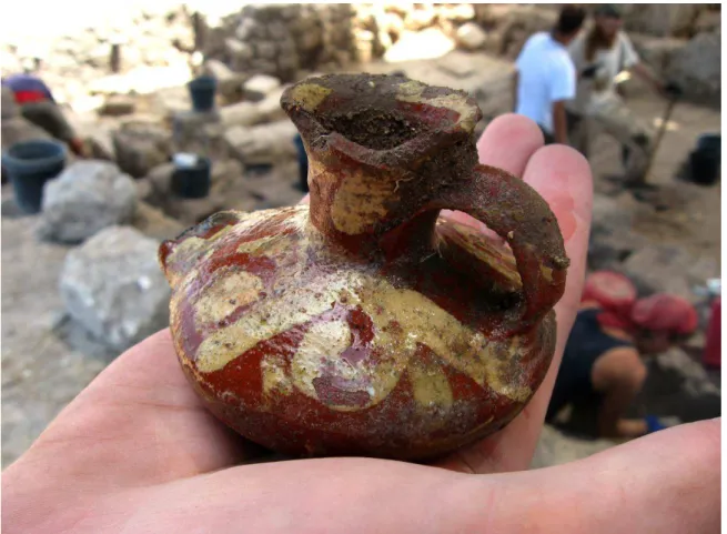
The classification of the stratified pottery finds is always undertaken on site during each excavation campaign (fig. 2). Therefore, Dr Lisa Yehuda has created a completely new database, into which finds from older excavations are already incorporated.
Fig. 2: A small Crusader period lamp, Beirut ware, 12th/13th century (photo by N. Walzer).
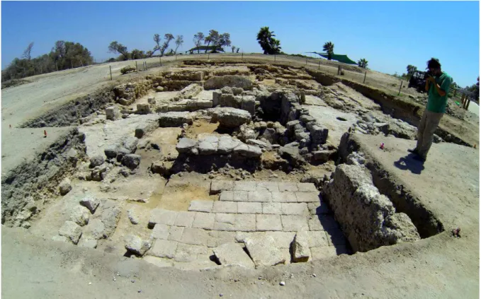
Fig. 3: Complete view of Area T, seen from the west.
The recent past is also an important part of the history of Arsur. In an aerial photograph of the British armed forces from 1923, numerous emplacements and trenches from the First World War are visible. One of these emplacements was excavated in Area U. Besides many cartridge cases, artifacts such as uniform buttons and different types of tins were also found in situ.
The small-scale structures in Area T (fig. 3) turned out not only to be in very good condition, but also very complex. Up until the end of the last campaign in 2014, the trench was extended repeatedly, until it reached 300 m2. Two complete house plans with entrances and elaborated ground plans, a kitchen and economic area, including a tabun (a mud oven) and a vaulted rubbish pit, were discovered. Multi-phase pavements, pillars, further rooms with screed floors, square pools, sewers – among them a channel covered by stone slabs – and obviously a cistern, reflect the diversity of this densely-occupied area at the southern border of the town. The excavation work will continue here in 2015.
Byzantine structures could not be definitely identified here. However, extensive settlement remains of the 9th and 11th century, which were rebuilt several times during the Crusader Period, were excavated. Some buildings showed significant marks of destruction by fire; a ballista stone and an arrowhead were among the findings.
Town and hinterland
For its supplies, the town did not rely solely on the small harbour, but also on a developed rural hinterland. The borders of the Crusader lordship of Arsur presumably go back to early Islamic times (fig. 4). Already in that period, the town was the principal town of a district (called kura or kuwar) (Khalilieh 2008: 159-160; Taragan 2004: 85). The adoption of the Muslim administrative organization made it possible for the Franks to execute their manorial rights in villages and towns and to collect taxes from harbours, markets and trade routes. For even after the Crusader conquest, the local population remained mostly in their homeland. In spite of this, the change of leadership had consequences for the settlement pattern.
The foundations of any agricultural use of an area are the natural conditions. Thus, the reconstruction of the historical conditions is an important aim of the project, because the landscape changed dramatically after the foundation of the state of Israel. Previously, parts of the extensive plain between the coast and mountain range were marshes, where water buffalos
The European Archaeologist – Issue No. 43: Winter 2015
77
grazed. The water coming from the mountains found only a few natural drains into the sea. The way to the sea was blocked by several lines of old cliffs of fossilized dune sand (kurkar). Out of the plains rise large isolated areas consisting of a reddish sandy soil (hamra), which are dry, but less fertile without artificial fertilization. Forests grew here until the end of the 19th century. In the Crusader period, a particularly large forest was located north of Arsur, which played an important role in the course of the famous battle of Arsur, a turning point during the third Crusade (Röhricht 1898: 585). Later, Baibars gathered his army here under the pretence of a lion hunt. The land in the Yarkon basin and at the foot of the Samaritan mountains, where alluvial soils predominate, was fertile. In addition, the river powered many flour mills. The mountainous regions were particularly used for livestock farming and olive groves.
In order to understand the settlement development during the medieval period, all available archaeological, historical and geographical information sources are collected and processed in a geographic information system (GIS). Most important is information from the time before and during the British mandate. Back then, many areas were surveyed systematically, so sites that are completely destroyed today are still preserved in photographs, written records and through finds. Up to now, more than 200 sites or single finds from the early Islamic, Crusader and Mamluk period have been assembled, which allow a first insight into the settlement process.
The preliminary results show that the coastal plain was densely populated and occupied by small rural settlements until the second half of the 10th century (Umayyads and Abbasids).
Since the Roman period, the area has been artificially drained, and the most favourable soils were used for agriculture. Obviously, the necessary installations were not maintained with enough care towards the end of the early Islamic period (Fatimids). Before the arrival of the Crusaders, the population seems to have decreased, the settlement thinned out and was concentrated in fewer places. Only some time after the establishment of the Kingdom of Jerusalem a new increase of population and settlements became apparent. In contrast, in the mountains, the settlement pattern persisted largely unchanged over the centuries.
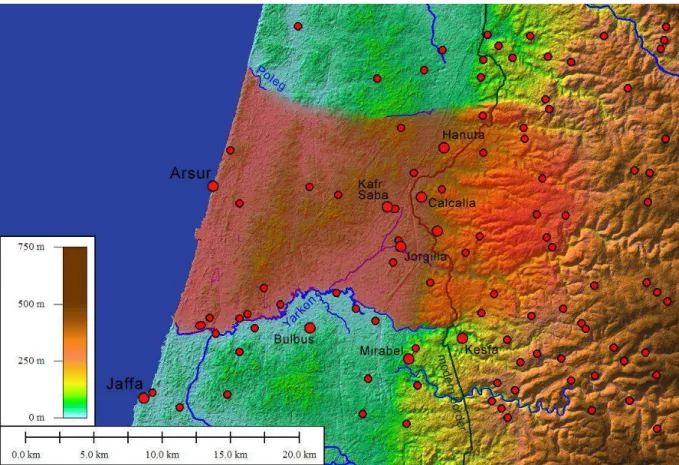
Fig. 4: All find spots of the Crusader period in the investigated area. The former lordship of Arsur is highlighted in red.
Fig. 5: Excavation work in Area T.
Town and castle formed the sole centre in the comparatively small dominion of Arsur. All other settlement remained far behind in size and importance. The rural environment was characterized by small villages or farmsteads. Of special importance were probably the revenues from the water mills.
As a result of the Mamluk conquest, the coastal plain became almost abandoned, without noteworthy settlements. Baibars made it the homeland of nomadic tribes. During this time, the country served as pasture ground. Permanent settlements were moved further eastward to the foot of the mountain range, where the population along the old caravan route from Cairo to Damascus increased considerably. Central functions of the major coastal towns Arsur and Caesarea, both having been destroyed by Baibars, were transferred to the inland town Caco (Qagun), halfway between the former capitals. The only remaining settlement near Arsur was a small village to the south, near the tomb of Sayyidna 'Ali, a holy Muslim man.
Archaeology in a conflict area
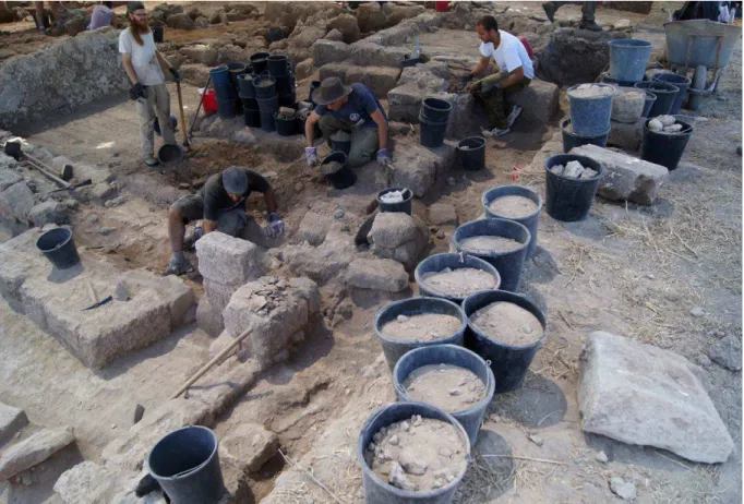
Originally, extensive excavations in Area U and archaeological surveys along the borders and inside the West Bank were planned for 2014, but had to be cancelled due to the political situation. While Israel can be described as a very safe country, the situation can change quite abruptly, as occurred in July and August 2014. It was no easy decision to continue the project during the Gaza war, especially since many foreign colleagues interrupted their research in Israel this year. Reliable project partners and colleagues in Israel, alongside our close contact with both the Federal Foreign Office the German embassy in Tel Aviv helped us to make our decision.
In the end, the excavation was continued as it has every summer, but, understandably, very few volunteers or Israeli students participated (fig. 5). As a result, the small team had to work even harder and was also subject to constant psychological pressure due to the political situation, the media and those who stayed at home. Luckily, the team was spared from rocket attacks, despite three alarms. But the sirens of neighbouring villages could be heard more often than not and army helicopters flew frequently along the coast to the south. It
The European Archaeologist – Issue No. 43: Winter 2015
79
should be mentioned here, as an interesting and important experience, how extremely different the various countries and their media reported on the ongoing conflict. This led from time to time to discussions and misunderstandings with friends and family members at home, as well as with participants and partners in Israel. It would certainly be desirable for archaeological research to focus on the scientific issues, stay out of current conflicts in a country, and try not to be exploited for one or the other side. We are nevertheless aware that this is not always possible and the mere execution of a project can sometimes be regarded as a political statement.
References
AVISSAR,M.and E.J.STERN,2005.Pottery of the Crusader, Ayyubid, and Mamluk Periods in Israel. Jerusalem: Israel Antiquities Authority (IAA Reports 26).
BEYER, G., 1950. Die Kreuzfahrergebiete Südwestpalästinas (1. Teil). Beiträge zur biblischen Landes- und Altertumskunde 68(2): 148-192.
ELLENBLUM, R., 1998. Frankish rural settlement in the Latin Kingdom of Jerusalem.
Cambridge: Cambridge University Press.
KHALILIEH, H. S., 2008. The ribāt of Arsūf and the coastal defence system in Early Islamic Palestine. Journal of Islamic Studies 19(2): 159-177.
PIANA, M. (ed.), 2008. Burgen und Städte der Kreuzzugszeit. Petersberg: Michael Imhof (Studien zur Internationalen Architektur- und Kunstgeschichte 65).
PRINGLE, D., 1986. The red tower (al-Burj al-Ahmar). Settlement in the Plain of Sharon at the time of the Crusaders and Mamluks A.D. 1099-1516. London: British School of Archaeology in Jerusalem (Monograph Series I).
RÖHRICHT, R., 1898. Geschichte des Königreichs Jerusalem (1100-1291). Innsbruck:
Wagnersche Universitäts-Buchhandlung.
ROLL, I., 1996. Medieval Apollonia-Arsuf: a fortified coastal town in the Levant of the early Muslim and Crusader periods. In: M. Balard (ed.), Autour de la première Croisade.
Actes du colloque de la Society for the Study of the Crusades and the Latin East (Clermont-Ferrand, 22.-25.6.1995): 595-606. Paris: Publications de la Sorbonne.
ROLL, I. and O. TAL, 1999. Apollonia-Arsuf. Final report of the excavations. Vol. I: The Persian and Hellenistic periods. Tel Aviv: Monograph Series of the Institute of Archaeology of Tel Aviv University 16.
STERN, E. J., 2012. ’Akko I, the 1991-1998 excavations: the Crusader-period pottery.
Jerusalem: Israel Antiquities Authority (IAA Reports 51, 2 Vols.).
TARAGAN, H., 2004. The tomb of Sayyidna ‘Ali in Arsuf. The story of a holy place. Journal of the Royal Asiatic Society, Third Series 14(2): 83-102.
TAL, O. and I. ROLL, 2012. Arsur: The site, settlement and crusader castle, and the material manifestation of their destruction. In: T. Harpak, O. Tal, H. Yohanan and I. Ziffer (eds.), The last supper at Apollonia. The final days of the Crusader castle in Herzliya: 8-51.
Tel Aviv: Eretz Israel Museum.
WIECZOREK, A., M. FANSA and H. MELLER (eds), 2005. Saladin und die Kreuzfahrer.
Mannheim: Reiss-Engelhorn-Museen / Mainz: Philipp von Zabern (Begleitband zur Sonderausstellung).