South American Hydrological Balance and Paleoceanography during the Late Pleistocene and Holocene (SAMBA)
Cruise No. M125
March 21 – April 15, 2016
Rio de Janeiro (Brazil) – Fortaleza (Brazil)
A. Bahr, A. L. Spadano Albuquerque, N. Ardenghi, S. J. Batenburg, M. Bayer, M. C. Catunda, A. Conforti, B. Dias, R. Díaz Ramos, L. M.
Egger, F. Evers, T. Fischer, K. Hatsukano, B. Hennrich, J. Hoffmann, S. Jivcov, S. Kusch, P. Munz, E. Niedermeyer, A. Osborne, J. Raddatz, A. W. Raeke, S. Reissig, U. Sebastian, N.
Taniguchi, I. Martins Venancio, S. Voigt, A. Wachholz
Editorial Assistance:
DFG-Senatskommission für Ozeanographie
MARUM – Zentrum für Marine Umweltwissenschaften der Universität Bremen
2016
The METEOR expeditions are funded by the Deutsche Forschungsgemeinschaft (DFG) and the Bundesministerium für Bildung und Forschung (BMBF).
Editor:
DFG-Senatskommission für Ozeanographie
c/o MARUM – Zentrum für Marine Umweltwissenschaften Universität Bremen
Leobener Strasse 28359 Bremen
Author:
Dr. André Bahr Telefon: +49-6221-54 6062
Institut für Geowissenschaften Telefax: +49-6221-54 5503
Universität Heidelberg e-mail: andre.bahr@geow.uni-heidelberg.de Im Neuenheimer Feld 234-236
69120 Heidelberg
Citation: A. Bahr, A.L. Spadano Albuquerque, N. Ardenghi, S.J. Batenburg, M. Bayer, M.C. Catunda, A. Conforti, B. Dias, R. Díaz Ramos, L.M. Egger, F. Evers, T. Fischer, K. Hatsukano, B. Hennrich, J.
Hoffmann, S. Jivcov, S. Kusch, P. Munz, E. Niedermeyer, A. Osborne, J. Raddatz, A.W. Raeke, S.
Reissig, U. Sebastian, N. Taniguchi, I. Martins Venancio, S. Voigt, A. Wachholz (2016) South American Hydrological Balance and Paleoceanography during the Late Pleistocene and Holocene (SAMBA) – Cruise No. M125 – March 21 – April 15, 2016 - Rio de Janeiro (Brazil) – Fortaleza (Brazil). METEOR-Berichte, M125, 47 pp., DFG-Senatskommission für Ozeanographie, DOI:10.2312/cr_m125
_________________________________________________________________________________
ISSN 2195-8475
Table of Contents
1 Summary ... 3
2 Participants ... 4
3 Research Program ... 5
4 Narrative of the Cruise ... 8
5 Methods ... 11
5.1 Hydrographic Measurements and Water Sampling ... 11
5.2 Pore Water Analysis ... 12
5.3 Plankton Sampling ... 13
5.3.1 Plankton Net ... 13
5.3.2 Plankton and Seawater Samples from Ship’s Pump ... 14
5.4 Hydroacoustics ... 14
5.4.1 Technical Description of the EM122 and EM710 Multibeam Sounders ... 14
5.4.2 Multibeam Data-Processing ... 15
5.4.3 Technical Description of the Sub-bottom Echosounder (Atlas PARASOUND) ... 17
5.4.4 Processing of Subbottom Data ... 18
5.5 Sediment Sampling ... 18
5.5.1 Devices and Operations ... 18
5.5.2 Core Sampling ... 19
5.5.2.1 Gravity/Piston Cores ... 19
5.5.2.2 Van Veen Grab, Multicorer and Box Corer ... 20
5.5.3 Foraminifera Sampling ... 22
5.5.4 Core Scanning ... 24
5.5.4.1 Color Scanning ... 24
5.5.4.2 XRF Scanning ... 24
6 Preliminary Results ... 24
6.1 Hydrography ... 24
6.2 Planktic Foraminifera ... 27
6.3 Hydracoustics ... 27
6.4 Sedimentology ... 30
6.5 Preliminary Stratigraphy and Correlation ... 34
7 Ship’s Meteorological Station ... 38
8 Station List M125 ... 39
9 Data and Sample Storage and Availability ... 44
10 Acknowledgements ... 45
11 References ... 46 Appendix (Core Descriptions)
1 Summary
R/V METEOR expedition M125 (“SAMBA”) focused on the influence of paleoceanographic changes off NE Brazil on the continental hydrological cycle. For this purpose, we obtained 202 m of gravity (24 stations) and piston cores (9) at seven sections on the shelf and continental slope close to river mouths from Cabo Frio in the south to the Rio Sao Francisco in the north. Coring stations were determined after intensive echosounder surveys (total: 1221 NM). On-board foraminiferal biostratigraphy, as well as color and XRF-scanning already provided first stratigraphic constraints, indicating the preservation of different regional paleoclimatic signals at the respective sections. Based on the preliminary stratigraphy, we retrieved high-resolution archives, covering Holocene sediments on the shelf and late Pleistocene sediments on the slope.
These high-resolution archives are complemented by long-term records covering up to 900 ka of continuous sedimentation at deeper sites at smaller rivers. For proxy-calibration and the study of present-day sedimentation dynamics and biogeochemical processes, surface sediments were sampled via multicorer (47), Van Veen Grab (6) and box corer (3). Water samples for determination of the water chemistry (trace elements, stable and radiogenic isotopes) and nutrient composition were retrieved by 55 CTD/Rosette casts. In addition, we run multinet-hauls at seven stations to investigate the planktonic foraminiferal communities in the water column down to 700 m water depth, complemented by filtering water from the ship’s pump twice a day.
Zusammenfassung
Im Rahmen der FS METEOR Expedition M125 (“SAMBA”) sollte der Einfluss von paläozeanographischen Veränderungen vor NE Brasilien auf den kontinentalen hydrologischen Kreislauf untersucht werden. Hierzu wurden insgesamt 202 m Sedimentkern mittels Schwerelot (24 Stationen) und via Kolbenlot (9) entlang von sieben Sektionen auf dem Schelf und Schelfhang in der Nähe von Flussmündungen zwischen Cabo Frio im Süden und dem Rio Sao Francisco im Norden gewonnen. Kernstationen wurden nach intensiven geophysikalischen Voruntersuchungen ausgesucht (Gesamtlänge der Profilfahrten: 1221 NM). Bereits an Bord konnten mittels Foraminiferen-Biostratigraphie sowie durch Farb- und XRF-Scans der Kerne erste Stratigraphien entwickelt werden. Diese zeigen, dass unterschiedliche klimatische Signale in den einzelnen Sektionen archiviert sind. Bei den abgedeckten Zeitintervallen handelt es sich zum einen um hochauflösende Datensätze des Holozäns und Spätpleistozäns, zum anderen um kontinuierliche Klimaarchive, die bei geringerer Sedimentationsraten bis zu 900 ka abdecken. Für die Kalibration von Proxys und das Studium rezenter sedimentärer und biogeochemischer Prozesse wurden Sedimente mittels Multicorer (47), Van Veen Greifer (6) und Kastengreifer (3) gewonnen. Zur Bestimmung der Wasserchemie (Spurenelemente, stabile und radiogene Isotope) und Nährstoff- Zusammensetzung wurden 55 mal die CTD mit Kranzwasserschöpfer eingesetzt. Zusätzlich wurden an sieben Stationen Planktonfänge mit dem Multischließnetz bis in Tiefen von 700 m durchgeführt, sowie zweimal täglich Meerwasser-Filtrate aus der Schiffspumpe entnommen.
2 Participants
Name Discipline Institution
1. André Bahr, Dr. Fahrtleiter / Chiefscientist UH
2. Silke Voigt, Prof. Dr. Sedimentology GUF
3. Ana Luiza Spadano Albuquerque, Prof. Dr. Paleoceanography UFF
4. Stefan Reissig Paleoceanography GEOMAR
5. Sietske Batenburg, Dr. Paleoceanography OXF
6. Philipp Munz, Dr. Paleoceanography TÜ
7. Nancy Taniguchi Paleoceanography USP
8. Igor Martins Venancio Paleoceanography UFF
9. Ulrich Sebastian, Dr. Mapping, GIS FST
10. Lisa M. Egger Geology UH
11. Tobias Fischer Geology UH
12. Alexander Wachholz Geology GUF
13. Julia Hoffmann, Dr. Paleoceanography GUF
14. Jacek Raddatz, Dr. Paleoceanography GUF
15. Stephanie Kusch, Dr. Watergeochemistry UC
16. Rut Díaz Ramos Pore waterchemistry UFF
17. Maria Carolina Catunda Geochemistry USP
18. Eva Niedermeyer, Dr. Organicgeochemistry BIK-F
19. Margret Bayer Technician, multinet TÜ
20. Alessandro Conforti, Dr. Geophysics IAMC
21. Anne Osborne, Dr. Watergeochemistry GEOMAR
22. Barbara Hennrich Micropaleontology UH
23. Nicolò Ardenghi Organic geochemistry BIK-F
24. Bruna Borba Dias, Dr. Micropaleontology UFF
25. Sandra Jivcov Organic geochemistry UC
26. Kenji Hatsukano Sedimentology UH
27. Florian Evers Technician GEOMAR
28. Tenente Jose Celso Observer
29. Andreas Wolfgang Raeke Bordwetterwarte DWD
BIK-F Senckenberg Biodiversity and Climate Research Centre (BiK-F), Senckenberg Gesellschaft für Naturforschung, Senckenberganlage 25, D-60325 Frankfurt am Main, Germany
DWD Deutscher Wetterdienst, Seeschifffahrtsberatung, Bernhard-Nocht-Straße 76, 20359 Hamburg, Germany
FST Fachschule für Technik, Schachtweg 2, 09599 Freiberg, Germany
GEOMAR GEOMAR Helmholtz-Zentrum für Ozeanforschung Kiel, Wischhofstrasse 1-3, 24148 Kiel, Germany
GUF Institut für Geowissenschaften, Goethe-Universität Frankfurt, 60438 Frankfurt am Main, Germany
IAMC Istituto per l'Ambiente Marino Costiero del CNR, Località Sa Mardini, 09170, Torregrande, Oristano, Italy
OXF Shell Geosciences Research Administrator, Department of Earth Sciences, University of Oxford, South Parks Road Oxford, OX1 3AN, United Kingdom
TÜ Universität Tübingen, Mikropaläontologie, Hölderlinstraße 12, 72074 Tübingen, Germany
UC Institute of Geology and Mineralogy, University of Cologne, Zülpicher Str. 49a, 50674 Cologne, Germany
UFF Departamento de Geoquímica, Universidade Federal Fluminense, Outeiro São João Baptista s./n., CEP24020-015 Niterói, RJ, Brazil
UH Institut für Geowissenschaften, Universität Heidelberg, Im Neuenheimer Feld 234- 236, 69120 Heidelberg, Germany
USP School of Arts, Sciences and Humanities, University of Sao Paulo, Av. Arlindo Bettio, 1000, CEP03828-000 Sao Paulo, SP, Brazil
3 Research Program
(A. Bahr)
The main scientific objective of R/V METEOR cruise M125 was to investigate the influence of changes in ocean circulation and insolation on the continental climate in eastern Brazil. The hydrological cycle in this region strongly depends on the intensity of the South American Summer Monsoon and the latitudinal migration of the Intertropical Convergence Zone. Especially in NE Brazil, precipitation is extremely seasonal with a long (8 months) drought season and a short rainy season. The long dry season make this region highly sensitive to changes in rainfall amount with potentially severe effects on terrestrial ecosystems, agriculture and energy supply (90% of Brazil’s energy derives from water power). Considering that NE Brazil currently experiences historic droughts, the paleoclimatic insights that will be gathered from the material retrieved during the M125 cruise will give insights into the potential impacts of future climate change and help to constrain the natural climatic variability.
Earlier studies demonstrated that orbitally forced modulation of solar irradiation and changes in the mode of oceanic circulation lead to abrupt shifts in the regional distribution of precipitation (Arz et al., 1998; Stríkis et al., 2011; Wang et al., 2004). This is evident for the Holocene (Stríkis et al., 2011), and is expressed by large-scale fluctuations during the late Pleistocene (Cheng et al., 2009; Cruz et al., 2009). For the scope of our project, the influence of changes in the configuration and ocean-current strength on continental climate are a central aspect. While there is ample evidence for the North Atlantic ocean mitigating climate change in South America (Arz et al., 1999b; Jaeschke et al., 2007), the degree of this northern-hemisphere impact varies strongly between different records. To investigate the origin of different responses to climate forcing on millennial and orbital time scales is the main target of the M125 expedition. Specifically, we focused on three major aspects and research questions:
Topic 1: The sensitivity of the hydrological cycle and environment in Eastern Brazil to external forcing
What are the regional-scale differences in rain-fall variability over the geologic past?
To what extent do northern hemisphere climatic changes influence E-Brazilian climate?
Do thresholds, leads and lags cause a strong non-linearity in the hydrological system and ecosystem variations?
Topic 2: Paleoceanography
What drives the variability of the Brazil Current, especially with regard to the North Atlantic influence?
How is the surface current variability related to reconfigurations of intermediate and deep water masses at the Brazilian Margin?
Topic 3: Sedimentary processes on the Eastern Brazilian shelf and slope
How are strong bottom currents on the Eastern Brazilian slope influencing sediment transport, and what drives their variability?
Within the framework of expedition M125, we aimed to integrate climatic proxies of terrestrial and marine origin from the same material to develop a comprehensive picture of the climate dynamics in E-Brazil. For this purpose, sediment cores from the shelf and continental slope off eastern Brazil (10°S – 23°S) have been taken. We focused on seven research areas that were distributed on the shelf and slope adjacent to the debouchments of the Paraiba do Sul, Rio Doce, Rio Jequitinhonha, Rio de Contas and Rio Sao Francisco. The particular location close to river mouths allows for obtaining terrestrial signals in marine sediment cores, while the N-S extension covered by all sites will provide insights into the spatial variability of past climate change.
Additionally, a comprehensive surface sediment, water and plankton sampling program was conducted for a precise local proxy calibration.
Strategy of the cruise:
The work programme for each working area comprised:
hydroacoustic surveys to identify suitable coring sites with continuous muddy sediment cover;
CTD/Rosette casts for water sampling down to approx. 2000 m water depth; as the demand for water sampling was quite high for REE and organic biomarker filtration, double casts were run at selected stations; shallow stations close to river mouths were sampled with a purpose-made bucket;
multicorer (MUC) and box corer (BC) deployment for surface sediment sampling, intended especially for proxy calibration studies and geochemical analyses of the upper sea floor sediments and interstitial water; in areas with suspected hardground/gravel cover a Van Veen grab was deployed prior to MUC or BC;
gravity and piston coring to retrieve long, continuous sedimentary archives;
plankton studies were carried out via multiple opening/closing net casts and filtering of water derived from the ship’s pump.
Sedimentary material from piston and gravity cores will be sampled onshore based on the ship- board stratigraphies developed from core logging data and biostratigraphy. This approach allows for targeting specific intervals in appropriate sample resolution, securing an effective treatment of the M125 sample material.
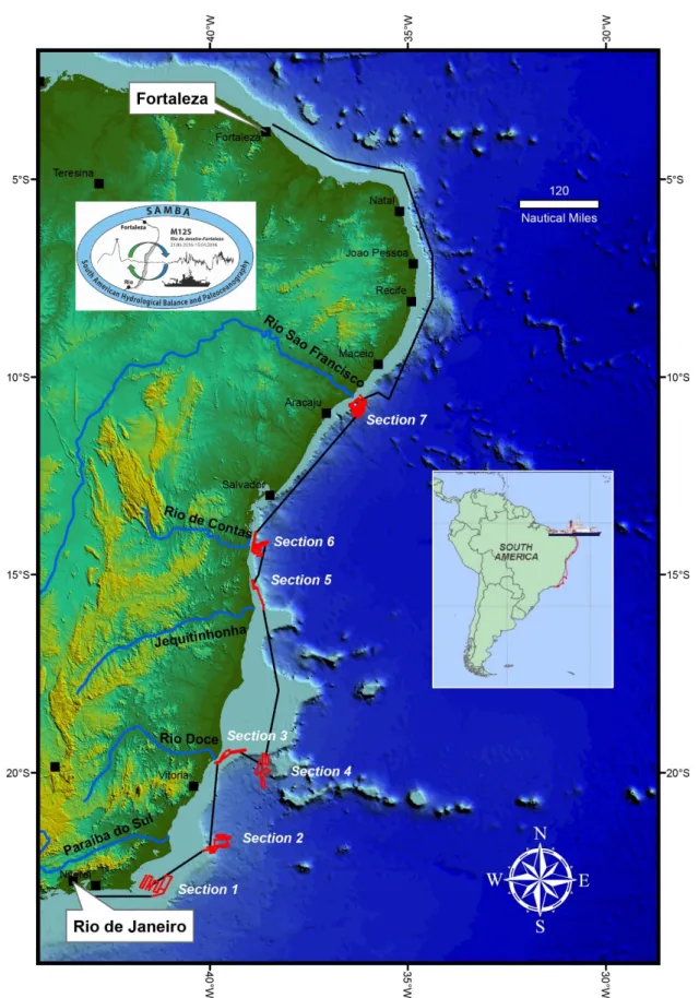
Fig. 3.1 Track chart of R/V METEOR Cruise M125. The seven main working areas (Sections 1-7) are indicated.
The cruise plan and work programme was followed as proposed (Fig. 3.1), aided by the excellent weather conditions. Only the work off the Rio Doce was shortened by one day, as sediment and water from this river suffered severe pollution due to a mining incident in November 2015. Here, the sampling programme was conducted under strict security measures to avoid any health risks.
The deployment of tools largely comprised routine sampling and surveys at designated locations, with most analytical work to be conducted post-cruise. Nevertheless, new discoveries and unexpected observations were made onboard which will generate a high impact on the scientific community. In particular, previously known cold-water corals were found to form extended mound provinces on the slope off the Paraiba do Sul in approx. 850 to 950 m depth. Core logging further provided the firm evidence that we retrieved excellent climate archives enabling the study of late Pleistocene/Holocene climate variability in high-resolution as well as for the long- term reconstruction of the South American monsoonal dynamics over the last approx. 900 kyr.
4 Narrative of the Cruise
On the 21st March 2016 the R/V Meteor left the port of Rio de Janeiro on time at 9 am, heading eastward over a calm sea to the first research area on the shelf off Cabo Frio. The first station (M125-1) was reached at 18:30 ship time where we deployed a shallow CTD. We routinely conducted echosounder pre-site surveys during the night in search of accumulations of muddy sediments of Holocene age as a coring target. During the night of 21st/22nd March we concentrated on the outer shelf, during the 22nd/23rd March on the inner shelf, and during the 23rd/24th on the middle shelf to achieve a full coverage of the seismic and sedimentary facies on the entire shelf.
Subbottom profiling indicates that the shelf is dominated by coastal dune-like and channel-fill deposits likely of Pleistocene age with a thin (approx. 2-4 m) Holocene veneer of muddy-sandy sediments. Due to the supposedly sandy to gravelly nature of the surface sediments, we first deployed a Van Veen Grab (VVG) to judge if the sediment was suitable for multicorer (MUC) sampling. It turned out that at least the upper 15 cm of the sediment were soft enough to allow for using the MUC, which we successfully did at all 9 stations over the three days we occupied the area off Cabo Frio. This material provided a sound data set of surface samples, to be used for a variety of purposes (e.g. proxy calibration). Although MUC deployment worked well, penetration by gravity coring of in total 9 attempts never exceeded 1.40 m, and cores were severely disturbed.
Apparently, the low recovery is likely due to the indurated and coarse grained-sediment texture.
In addition to sediment sampling, 10 CTD casts were used to get insights into the water column structure and to sample water. As during the following days until the end of the voyage, we routinely took samples from the ship’s pump for plankton filtering twice a day, between 8–10 am and 5–7 pm. We finally finished work in the area off Cabo Frio at 11:15 on the 24th March and steamed with 11 kn to the next working area, the slope E off the Rio Paraiba do Sul (Section 2).
At 20:30 on the 24th March, we started a downslope echosounder transect at Section 2. As confirmed by the mulitbeam/parasound (MBPS) over the next 3 days, the sea floor morphology comprises a complex channel system. Aside of channel/levee systems and drapes of hemipelagic sediments, we found mound-like structures concentrated in a patch in about 850 to 870 m water depth, with occasional strong backscatter on the top. We targeted two of these structures as it was suspected that they represented deep-water coral mounds, related to the presence of the Antarctic Intermediate Water (AAIW). Box coring confirmed the presence of dead corals at Site (M125-24)
where we took a gravity core. The opened core demonstrated that the corals only inhabited the top few centimeters, but were absent below. A second Site (M125-34) targeted the top of a pinnacle in about 870 m water depth, within the AAIW. Box coring retrieved large but mostly dead specimens of deep water corals. Gravity coring retrieved 5.83 m of sediment at the same site.
Further, we took 3 gravity cores within different water depths (429 m, 961 m and 2020 m) in order to reconstruct the variability of the different bottom water masses at the Brazilian upper and middle slope. The cores retrieved a maximum of 6.86 m of sediment via gravity coring; unfortunately deployment of the piston corer failed due to technical problems. Aside of gravity coring we deployed the MUC at 4 locations, a total of 7 CTD casts and one multinet. After completing the last station the vessel begun with the 12 h transit to the third research area, the shelf close to the mouth of the Rio Doce (Sections 3 and 4).
On the 28th March at 7 am we entered the area on the shelf south of the Doce River mouth (Section 3). Our target here was to retrieve a succession of Holocene sediment delivered by the river as an archive of climate variability in the hinterland. A PARASOUND survey conducted in the morning until noon parallel to the coast indicated a blanket of up to 8 m of Holocene sediments.
We deployed the gravity corer very proximal to the river mouth (M125-38 in 18 m water depth) within the suspension-loaded river plume retrieving 4.70 m of sediment at station M125-43. In addition, we took four MUC and CTD casts in varying distances to the river mouth. Surface samples close to the river mouth clearly showed the presence of reddish clay on top (maximum thickness: 4 cm) relating to an environmental disaster occurring in November 2015, when the collapse of a dam of an ore mine in the upper reaches of the Rio Doce led to the discharge of enormous amounts of heavy metal-enriched sediment and water downstream into the sea. During the night of 28th/29th March, an MBPS survey was run in E-W direction towards the inner shelf.
The geophysical data clearly showed an elongated lens of muddy material north of the present-day river mouth, reaching approximately 5 km into the inner shelf. Here we placed four MUC and CTD casts in an E-W transect along the muddy patch, including a gravity core (M125-43) in 38 m water depth which brought up 2.30 m of stiff muddy to slightly sandy sediment. Due to the polluted nature of the river sediment, strict measures were taken to avoid health and contamination risks during the entire station work at the Rio Doce area.
After we finished station work on the shelf at 11:15 am on the 29th March, we steamed 35 NM to the 4th working area, the southern slope of the Abrolhos Bank east off the Rio Doce (Section 4). Station work started at 5:15 pm on the same day with CTD and multinet casts. At 9 pm a MBPS survey started, continued until 8 am in the morning of 30 March. The survey covered the slope between 100 and 1000 m to identify potential coring opportunities on the shallow slope. Four sites were targeted, the first being M125-48 in 258 m water depth located on an otherwise erosive terrace with a package of apparently non-eroded strata. However, as the MUC deployment evidenced the presence of relatively coarse sandy material we did non deploy the gravity core as originally planned. The second coring station (M125-49) was situated in 450 m water depth and yielded 7.00 m of sandy material. The third site (M125-50) at 900 m locates within the proximity of a channel, however, not within the reaches of its levee system. Via piston core we retrieved 13.16 m of muddy sediment. At the fourth station (M125-52; 650 m), a gravity core of 8.46 m length was taken. After station work, a MBPS survey between 1000 and 2000 m water depth was conducted until 07:45 am in the next morning (31.03.).
One station at 1966 m water depth (M125-55) was selected at a morphological high situated within the Rio Doce canyon system. After deployment of CTD and four multinet casts, a multicorer and a piston corer were retrieved. After finishing the station work at 6:20 pm, the METEOR steamed to the starting point of the 65 nm overnight-survey focusing on the middle and upper slope in water depth between 900-1700 m. The objective here was to find suitable locations for two core sites located in approx. 1300 and 1600 m water depth. This survey was completed at 7 am in the next morning (01.04.2016). Two sites for water/sediment sampling via MUC and piston coring were selected. The first one (M125-59, 8 m recovery) in 1769 m water depth situates on a morphological high, with no indication of active deposition from down-slope transport. A second site (M125-61, 1337 m depth, 10.17 m recovery) was located on a less steep morphology on the slope of the Bernard Bank with presumably low input of terrigenous material. Next to the 6 gravity/piston cores, we deployed 7 MUCs and 10 CTD/rosette and 2 multinets.
After finishing work on the intermediate-depth sites, we steamed to the shelf off the Rio Jequitinhonha (Section 5) where we started with a MBPS survey parallel to the coast-line at 8:50 pm (2nd March), until the next day (3rd March) at 7:15 am. The shelf morphology was characterized by a flat surface with only very thin to absent Holocene sediments of coarse (sandy) nature, cut by a very steep and deep (500 m) channel close to the present-day river mouth. An exception was an infilling of a trough-like structure over a rough subsurface morphology presumably of late Pleistocene age. Here (station M125-67), we took water samples by means of a CTD, and sampled sediment by MUC and gravity coring. The sediment turned out to be soft mud and core recovery was 4.97 m with a 5 m core barrel. After this successful attempt, we left Section 5 and steamed to Section 6 on the shelf and slope off the Rio de Contas.
In the evening of the 3rd April, we started work on Section 6 with CTD casts in 2000 m water depth combined with multinet catches, followed by a MBPS survey on the slope until the next morning. The survey was completed at 7 am on the next morning (4th April). The outer shelf appeared to have only a limited recent sediment cover with no suitable coring target. The steep slope down to 1600 m water depth was, at least in the surveyed area, dominated by channel-levee systems with no suitable coring sites above this interval. Below, the PARASOUND profiles revealed intervals with draping reflections down to 1850 m. We chose one location (M125-72) with a well-developed drape at 1743 m water depth. The piston core had an excellent recovery with 13.43 m of sediment, however, one 5 m plastic liner was complete broken length-wise. We stabilized the liner with tape and another liner, but did not open the liner onboard as its halves would not fit into D-tubes. Further downslope we targeted one location (M125-73) at 2100 m water depth. Station work finished at 7:30 pm with the successful retrieval of the piston core with 12.49 cm recovery. Both cores showed quite regular interbedding of lighter and darker brownish intervals, reminiscent of core M125-55 from the Rio Doce slope, but with a generally higher carbonate content. We steamed to the start of the MBPS track which began at 8:30 pm and lasted until 7 am the next morning (5th April). The track focused on the upper slope between 400 to 1500 m water depth. We identified three potential coring targets that, based on the subbottom and multibeam data, were outside the influence of the extensive and active canyon systems. The deepest site (M125-77) was located in 1401 m water depth on top of a ridge extending downslope.
Site M125-78 was located on a slope section with well-defined draping sediments in 850 m water depth, within the AAIW. The shallowest Site (M125-80) in 427 m was located on a high as well.
Coring was successful at all Sites, retrieving up to 13.86 cm of sediment at station M125-78. After completing station work we continued with a MBPS survey from 8:45 pm to 7 am the next day (6th April). Here, we focused on the shelf, which we explored in a N-S transect in search of a suitable coring position. However, similar to the shelf off Cabo Frio, the shelf off the Rio de Contas was sediment-starved. A more or less continuous blanket of Holocene deposits with a maximum thickness of only 2 m could be found. We occupied six stations for water and surface sediment sampling (via MUC), retrieving muddy sediment. Gravity coring brought 2.50 m of sediment. We finished station work at the Rio de Contas Area at 13:30 with in total 12 CTDs, 10 MUCs, 3 gravity corers, 3 piston corers, and 1 multinet station.
After steaming for 22 h, we arrived at the first station on the slope at 2157 m water depth off the Rio Sao Francisco at 11:50 am on the 7th April, starting with CTD and multinet runs, followed by slope-shelf echosounder transects until 7 am (8th April). The results show a shelf covered with 10 m of Holocene sediment, but a highly dynamic slope which is deeply cut by channels.
Therefore, identification of suitable coring sites on the slope was problematic. As coring sites we selected M125-93 and -95 (960 m and 1901 m water depth, respectively), on elevated positions.
After CTD and multinet deployment, a MBPS survey was conducted during the night of 8th/9th April on the upper slope and shelf. Similar to the previous survey, a deeply incised slope at which we could only locate one potential coring target at 1201 m water depth (M125-102). In addition, we sampled water and surface sediment on the shelf, close to the Rio Sao Francisco debouchment.
During the night of the 10thApril, we continued the MBPS survey on the shallow to intermediate depth slope (1500 – 500 m). On a NW-SE trending ridge between deeply incised channels, we identified a position with potential cold-water mounds on top of a pinnacle (927 m) with high backscatter. This site (M125-107) was probed with a box corer, however, without retrieving coral specimens. One reason for the failure to retrieve corals might be that the required exact positioning of the tool at sea bottom was impeded by strong bottom currents and a non-functioning POSIDONIA transponder. In addition, we deployed a gravity core in 704 m water depth (M125- 108) and a piston core in 1072 m (M125-106) on the ridge, with the hope to find sediment less affected by down-slope transport than on the previous sites off the Rio Sao Francisco. The station work on the 10th April has been concluded by multinet catches. On the night 10th/11th April we continued with a MBPS survey on the shelf, mapping the Holocene sediment cover proximal to the coast. Three sites forming an along-shore transect have been chosen for surface and sediment sampling, including one coring station (M125-115), the last station of M125. Here, we obtained 7.77 m of very soft, muddy sediment, close to the mouth of the Rio Sao Francisco. After finishing station work we started with steaming to Fortaleza at 12:30 am on the 11th April. We arrived at Fortaleza in the morning of the 14th April, and after one day on anchorage, entered the harbor at 8:30 am on the 15th April.
5 Methods
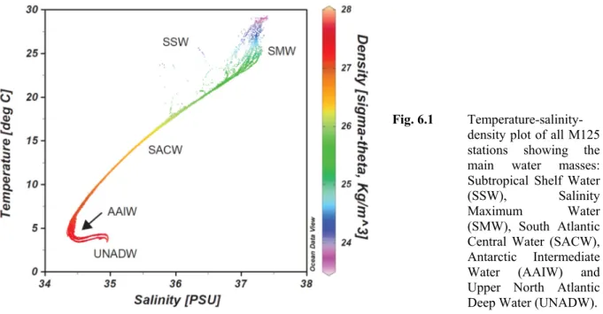
5.1 Hydrographic Measurements and Water Sampling
(A. Osborne, A. L. Albuquerque, S. Kusch, E. Niedermeyer, N. Ardenghi)
Conductivity-Temperature-Depth (CTD) casts were performed at each station. The objectives of the CTD casts were to characterize the water masses present in the seven working areas,
including river water dispersal, and to produce sound-velocity profiles for the Multi-Beam and PARASOUND hydroacoustic data processing.
M125 used the METEOR’s own Seabird SBE 9 CTD device, which is fitted with two temperature sensors, two conductivity sensors, a pressure sensor, an oxygen sensor and a fluorometer. The deck unit SBE 11plus V5.2 communicated with the underwater device.
Additionally, a small RBR XR-620 CTD was deployed for selected shallow stations and the multi-net stations and recorded conductivity, temperature and pressure. Both the ship and the small CTD were deployed at stations M125-1-1 and M125-69-4 in order to calibrate the small CTD to the ship’s CTD.
A bbe Moldaenke FluoroProbe was used to determine the concentration of total chlorophyll, green algae, blue- green algae, diatoms, cryptophytes, and indifferent yellow substances by spectral fluorometry. The sampling rate was 2 seconds. The FluoroProbe was mounted to the Multinet on each plankton station, time synchronized and operated with 0.5 m/s.
Water samples were taken with the shipboard Rosette, equipped with twenty-four 10-L Niskin bottles. The objectives of the water sampling were to characterize the water masses present, and to calibrate and develop paleoproxies. The types of samples and the depths at which they were taken varied between stations according to each research objective (Table 5.1).
Surface water was collected in the shelf area of Sections 6 and 7 using a 25 L plastic canister, lowered on a rope. Bottom water samples were also taken from selected MUC stations in all sections.
Table 5.1 Types and amount of water samples taken.
Researcher Analyses Purpose of water sampling Volume Raddatz,
Albuquerque δ18O, δ13C Calibration of paleoproxies, water mass
identification 0.1 L
Albuquerque Nitrogen, nutrients δ15N_NO3, δ18O_NO3 and δ15N_particulate proxy calibration
5 L Albuquerque Transcriptonics Verifying active genes related to the
nitrogen cycle 6 L
Voigt Lithium Calibration of paleoproxies, indication of
weathering input 0.02 L
Niedermeyer Biomarkers Calibration of paleoproxies 10-90 L
Osborne Trace and Rare Earth Element Calibration of paleoproxies, behavior in
estuaries and shelf, continental input 1 L Osborne, Bahr Trace and Rare Earth Elements
(0.2 µm filtered at rosette)
Calibration of paleoproxies, behavior in estuaries and shelf, continental input
0.125 L Osborne Nd and Ba isotopes
(0.2 µm filtered at rosette) Calibration of paleoproxies, water mass
identification 10 L
--- Salinity Instrument calibration (CTD) 0.25 L
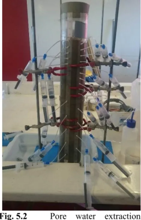
5.2 Pore Water Analysis
(R. Díaz)
Pore water was extracted by using the rhizon technique (Seeberg-Elverfeldt et al., 2005) in multicores from 15 stations. The rhizons were inserted directly into the sediment through pre-
drilled holes along the tube (Fig. 5.2). In order to prevent oxidation during handling, all pore water samples for were processed within a N2-filled glove bag. The samples will be analyzed for sulfate (SO42-) and sulfur isotopic composition (δ34SSO42-), sulfide (H2S), carbon isotopic composition of dissolve inorganic carbon (δ13CDIC), oxygen isotopic composition (δ18O), trace elements, iron II (Fe2+), nitrate (NO3‒), nitrite (NO2‒), ammonium (NH4+), phosphate (PO43-), and dissolved silica (DSi). In the glove-bag, 1 mL of each water sample was placed in 2 mL Eppendorf tubes (conditioned with 100 μL 1% HNO3 Merck PA) for trace metals analyses. Another sub-sample of 1 mL was stored in a 2 mL Eppendorf tube containing 100 μL of a 5% Zn-acetate solution (Merck PA) for ΣH2S analysis. Sub- samples of 1 mL for Fe (II) analyses were stored in 2 mL Eppendorf tubes (conditioned with 10 µL HCl 5 M). All these samples were stored at 4°C. Another sub-sample of 1 mL was stored and frozen in 5 mL amber vials with 10 μL HCl for PO43- analysis.
For DSi analyses, 0.5 mL sample was stored and frozen in 2 mL Eppendorf tubes. For nitrate (NO3‒, NO2‒ and NH4+ analyses, 4.5 mL sub-samples were kept frozen into 5 mL amber vials. For the δ18O analyses, 2 mL of sample was stored in a glass vial of 2 mL and for the δ13CDIC analyses 2 mL of pore water sample was filtered and stored in 2 mL amber vials, both fractions were stored at 4°C.
5.3 Plankton Sampling 5.3.1 Plankton Net
(M. Bayer, P. Munz)
Planktic foraminifera were collected for population analyses and geochemical proxy calibration, using stratified vertical net hauls with a Hydrobios MultiNet Midi multiple opening-closing net with an inlet size of 50 x 50 cm and a mesh size of 0.1 mm. Vertical opening depths were monitored with an integrated pressure sensor and divided into nine standard depth intervals.
Shallow casts sampled the uppermost 100 m of the water column in 20 m-intervals, deep casts the uppermost 700 m in the intervals 700–500 m, 500–300 m, 300–200 m, 200–100 m and 100–0 m (Table 5.2). Slacking and hoisting was done at 0.5 m/s. After each haul, the net bags were carefully washed with sea water from the ship's pump and the cups' mesh cloth was washed and rinsed with filtered sea water. Each station was run with double hauls. The samples of the first set for later faunal analyses onshore were decanted, transferred to 50 ml Kautex bottles and preserved with 95 % Ethanol to a concentration of ~50 %. Samples for geochemical analyses were picked on board using a stereo dissecting microscope. Planktic foraminiferal individuals were determined to species level according to the taxonomy of (Hemleben et al., 1989), transferred to Eppendorf vials and preserved with 95 % ethanol.
Fig. 5.2 Pore water extraction using the rhizon technique.
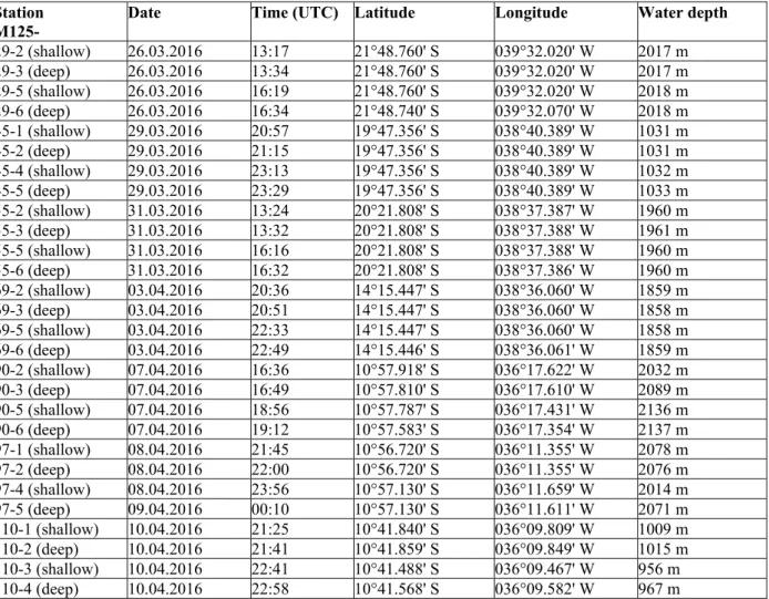
Table 5.2 Station list of shallow and deep stratified vertical plankton net casts.
Station
M125- Date Time (UTC) Latitude Longitude Water depth 29-2 (shallow) 26.03.2016 13:17 21°48.760' S 039°32.020' W 2017 m 29-3 (deep) 26.03.2016 13:34 21°48.760' S 039°32.020' W 2017 m 29-5 (shallow) 26.03.2016 16:19 21°48.760' S 039°32.020' W 2018 m 29-6 (deep) 26.03.2016 16:34 21°48.740' S 039°32.070' W 2018 m 45-1 (shallow) 29.03.2016 20:57 19°47.356' S 038°40.389' W 1031 m 45-2 (deep) 29.03.2016 21:15 19°47.356' S 038°40.389' W 1031 m 45-4 (shallow) 29.03.2016 23:13 19°47.356' S 038°40.389' W 1032 m 45-5 (deep) 29.03.2016 23:29 19°47.356' S 038°40.389' W 1033 m 55-2 (shallow) 31.03.2016 13:24 20°21.808' S 038°37.387' W 1960 m 55-3 (deep) 31.03.2016 13:32 20°21.808' S 038°37.388' W 1961 m 55-5 (shallow) 31.03.2016 16:16 20°21.808' S 038°37.388' W 1960 m 55-6 (deep) 31.03.2016 16:32 20°21.808' S 038°37.386' W 1960 m 69-2 (shallow) 03.04.2016 20:36 14°15.447' S 038°36.060' W 1859 m 69-3 (deep) 03.04.2016 20:51 14°15.447' S 038°36.060' W 1858 m 69-5 (shallow) 03.04.2016 22:33 14°15.447' S 038°36.060' W 1858 m 69-6 (deep) 03.04.2016 22:49 14°15.446' S 038°36.061' W 1859 m 90-2 (shallow) 07.04.2016 16:36 10°57.918' S 036°17.622' W 2032 m 90-3 (deep) 07.04.2016 16:49 10°57.810' S 036°17.610' W 2089 m 90-5 (shallow) 07.04.2016 18:56 10°57.787' S 036°17.431' W 2136 m 90-6 (deep) 07.04.2016 19:12 10°57.583' S 036°17.354' W 2137 m 97-1 (shallow) 08.04.2016 21:45 10°56.720' S 036°11.355' W 2078 m 97-2 (deep) 08.04.2016 22:00 10°56.720' S 036°11.355' W 2076 m 97-4 (shallow) 08.04.2016 23:56 10°57.130' S 036°11.659' W 2014 m 97-5 (deep) 09.04.2016 00:10 10°57.130' S 036°11.611' W 2071 m 110-1 (shallow) 10.04.2016 21:25 10°41.840' S 036°09.809' W 1009 m 110-2 (deep) 10.04.2016 21:41 10°41.859' S 036°09.849' W 1015 m 110-3 (shallow) 10.04.2016 22:41 10°41.488' S 036°09.467' W 956 m 110-4 (deep) 10.04.2016 22:58 10°41.568' S 036°09.582' W 967 m
5.3.2 Plankton and Seawater Samples from Ship’s Pump (B. Hennrich, A. Osborne)
Plankton samples were taken from the ship's seawater membrane pump every morning (8–10 am) and afternoon (5–7 pm) from 22.03.2016 until 11.04.2016 (am only). No samples were taken during Section 3 (28-29.03.16) because of the risk of contamination from the Rio Doce. The ship's pump is located at the front of the ship at 3.5 m water depth. Before sampling the date, time, position (latitude/longitude), temperature and salinity (from the vessel's thermosalinograph), water meter reading (precise to ±1 L) and whether the vessel was on station or transit was recorded. For stable isotope analysis samples for δ18O and δ13C were taken, the latter was poisoned with 25 mg CuSO4 powder. Afterwards 1 m³ of seawater was run through a sieve with 63 µm mesh size. At the end of the sampling the above mentioned parameters were recorded again. The plankton in the sieve was then transferred into a Kautex bottle, filled up with 1/3 seawater and 1/3 ethanol and stored at room temperature. In total 37 plankton samples were taken.
5.4 Hydroacoustics
(A. Conforti, S. J. Batenburg and K. Hatsukano)
5.4.1 Technical Description of the EM122 and EM710 Multibeam Sounders
During the M125 cruise, two hull-mounted echosounder systems were used for bathymetric mapping; the Kongsberg Simrad EM 122, which is designed for use in middle and deep water depths and the Kongsberg Simrad EM 710 for bathymetric mapping in shallow water depths.
The EM122 system provides a tool for accurate bathymetric mapping down to full ocean depth.
Basic components of the system are two linear transducer arrays in a Mills Cross configuration with separate units for transmitting and receiving. The nominal sonar frequency is 12 kHz with an angular coverage sector of up to 150° and 432 soundings per swath. The emission cone is 150°
wide across the track, and 1° wide in the along-track direction. Reception is obtained from 288 beams, with widths of 2° across track and 20° along track. Thus, the actual footprint of each beam has a dimension of 1° by 2°. The achievable swath width on a flat seafloor will usually be up to 6 times the water depth dependent on the roughness of the seafloor. The angular coverage sector and beam pointing angles may be set to vary automatically with depth to obtain maximum coverage.
Using the high-density mode, which creates 432 soundings from 288 beams, and the dual swath mode (2 swaths per ping), 864 isolated equidistant depth values are obtained, perpendicular to the track for each ping. Using the detected two-way travel time and the beam angle known for each beam, and taking into account ray bending due to refraction in the water column, depending on sound speed variations, depth is calculated for each beam. A combination of amplitude (central beams) and phase (slant beams) is used to provide measurement accuracy, practically independent of the beam pointing angle. Besides the depth values, the EM122 also provides backscatter information, pseudo-side-scan images, as well as backscatter from within the water column.
The EM710 multibeam echo sounder is a high- to very-high-resolution seabed mapping system.
The minimum acquisition depth is less than 3 m below its transducers, and the maximum acquisition depth is specified at 2,000 m water depth. However, the quality of the EM710 data degrades significantly in water depths greater than 600 m. The across-track coverage (swath width) can reach up to 5 times the water depth. The EM710 operates at sonar frequencies in the range of 70 to 100 kHz. The transmit fan is divided into three sectors to maximize range capability but also to suppress interference from multiples of strong bottom echoes. The sectors are transmitted sequentially within each ping, and use distinct frequencies or waveforms. The along-track beam width of the system installed on RV METEOR is 1 degree. A ping rate of up to 25 pings per second is possible, and the transmit fan is electronically stabilized for roll, pitch and yaw. Like the EM122, the EM710 has a reception beam width of 1°. The number of beams is 256, or 400 in high- resolution mode, and the beam spacing may be set to equiangular or equidistant. The received beams are electronically stabilized for roll. A combination of phase and amplitude bottom detection algorithms is used to provide soundings with the best possible accuracy. Additionally, an integrated seabed acoustic imaging capability and a real-time display window for water-column backscatter are provided.
5.4.2 Multibeam Data-Processing
For the purpose of the cruise, the data acquired during each night’s survey had to be available for the planning of station work in the morning. Therefore, a first extraction of bathymetric data of both systems was performed without any processing (Figs. 5.5–5.8).
Data extraction and post- processing were performed using the open-source software package MB-Systems available in Poseidon Linux on board. For initial plotting, the data were gridded at a lateral resolution of 50 or 25 m for EM122 and 10 or 5 m for EM710, depending on the depth range. Additionally, grids of 25 or 15 m for EM122 and 5 or 2 m for EM710 were applied. In some specific areas of major interest, bathymetric data from both the EM710 and the EM122 have been post-processed,
applying some degree of filtering and removal of spikes.
These procedures were performed with the Mb-edit, Mb- editviz and Mb-grdviz tools, available in the MB-System package. A tide gauge correction has been applied only on selected data during post processing, using a tide prediction model for each acquisition section, on the base of a regional model of barotropic tide (Egbert and Erofeeva, 2002). The tide prediction model was developed on shore prior to the cruise by Giovanni Quattrocchi (IAMC CNR, Oristano, Italy).
A quality control of EM710 data was also performed on shore, by Alessandro Bosman (IGAG-CNR, Rome Italy), on a sample dataset. It was found that the acquired raw data were of good quality, apart from one problem, which was related to a roll compensation error, estimated to be about
±15 cm. To correct this, it is advised to perform manual retracing on the data during post-processing.
In some selected areas, backscatter data have been processed to support the morpho-bathymetric and seismic interpretation. This processing has been performed with MB-System tools (mbbackangle, mbfilter, mbgrid etc).
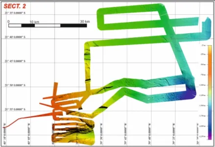
Fig 5.5 Digital elevation model of Section 2.
Fig 5.6 Digital elevation model of Section 4.
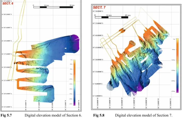
Fig 5.7 Digital elevation model of Section 6. Fig 5.8 Digital elevation model of Section 7.
5.4.3 Technical Description of the Sub-bottom Echosounder (Atlas PARASOUND) During cruise M125, the sub-bottom echo sounder system PARASOUND P70 (Atlas Hydrographic) was used to obtain information from the shallow subsurface to aid the identification of suitable coring localities. The PARASOUND P70 system uses the parametric effect, which occurs when very high (finite) amplitude sound waves are generated. If two waves of nearby frequencies are generated simultaneously, also the sum and the difference of the two primary frequencies are emitted. The PARASOUND P70 has a range of 18–33 kHz for the first primary high frequency (PHF). The second PHF can be produced in the range of 18.5–39 kHz, leading to a frequency range of 0.5–6 kHz with a beam width of 4.5° for the parametric secondary low frequency (SLF). Additionally, also the sum of the primary frequencies and the secondary high frequency (SHF), can be recorded. Theoretically, SLF data can achieve a vertical resolution of down to <15 cm and a maximum penetration of 100 m below seafloor. The sediment penetration is strongly dependent on local seabed conditions, stratigraphy and grain size of the sediment.
During this cruise, a maximum penetration depth of 50 m was achieved in muddy sediments. The PHF is used to calculate water depth with the aim to adapt ping rates automatically and to visualize backscatter in the water column. The Atlas PARASOUND P70 provides 3 different modes of signal transmission, one of which is the ‘Single Pulse Mode’, used if the full water column has to be recorded. In contrast, using the ‘Quasi Equidistant’ or the ‘Train Pulse’ transmission mode leads to a higher horizontal resolution. During M125, the PARASOUND P70 system was exclusively used in 'Quasi Equidistant' mode, with a wavelet designed to contain a single period. The desired SLF was set to 3.5 kHz with a desired PHF of 18 kHz. However, the resulting frequencies tend to
vary slightly due to technical restraints during signal generation. SHF was recorded to be available for later comparison. The emitted signals where amplified maximally to reach optimal penetration.
The acquisition software HYDROMAP CONTROL applies a receiver gain on the data, which varies automatically depending on the strength of the received signal. The data acquired were stored as RAW files in ASD format and in PS3 and SEGY format. Whilst storing lines in SEGY format, the applied delay is not recorded by the Parastore software. A separate log of applied delays was kept to correct the delay afterwards, file-by-file, during processing.
5.4.4 Processing of Subbottom Data
Initial focus was on the secondary low frequency (SLF) data, as these accurately record the stratigraphic variation in the investigated sedimentary successions. All the acquired SLF data were processed with a fast procedure using SEISPHRO LCL 2.0 (Gasperini and Stanghellini, 2009).
This software is ideal for onboard sub-seafloor investigation, as it enables the processing of data in less than 2 min after the acquisition of a line.
The data processing was performed on SEGY files and consisted of a few rapid steps: 1) signal normalization of selected data within a 16 bit dynamic range, 2) application of linear gain on selected data, 3) optionally, performed in some cases: muting of the water column depth and application of time variant gain control, 4) optionally, performed in few cases: deconvolution of spikes, 5) in very few cases, where swell correction was not applied due to a malfunction of PARASOUND sensors: the application of the Seisphro swell filter on data during post-processing.
The processing operations were not stored separately, as the processing flow can be applied instantly on the original SEGY files.
5.5 Sediment Sampling 5.5.1 Devices and Operations
(J. Raddatz)
The Veen-Grab was primarily used for ground-truthing to decide for further coring actions. The Van Veen-Grab was deployed at 6 stations. If sediments appeared to be undisturbed, surface samples were taken from 0-2 cm. The grab was lowered with 0.5-0.7 m/s and subsequently heaved with 1.0 m/s.
At locations where the sediment surface appeared to be of rather larger grain size, the giant box corer was used. This tool is able to penetrate an undisturbed sediment body up to 60 cm deep with a sediment surface area of 50x50 cm. The giant box corer was only applied 3 times,
especially at sites with cold-water coral appearances.
The multicorer (MUC) was deployed 49 times in total during M125. The MUC was lowered with varying speed between 0.3 and 1.0 m/s depending on water depth which varied roughly between 20–2000 m. Over the final 20–50 m the MUC was lowered with a speed of ~0.5 m/s until seafloor contact, monitored through cable tension. The multicorer was left on the seafloor for a few seconds and then pulled out with a speed of 0.5 m/s to guarantee rapid closure of the tubes. Finally, the MUC was heaved on deck with a speed of 1 m/s.
On M125 two different gravity core devices were deployed. The small gravity corer applied has a core diameter of 12.5 cm and a barrel of ~1.3 tons and used for 5 m long cores. It was lowered with 1 m/s to the seafloor and was then pulled out with a speed of 0.3 m/s. Heave
velocity was 1.0 m/s. For longer cores the piston corer (2.8 tons) was used as a gravity corer with core length of up to 10 m. In total both were deployed 27 times.
The GEOMAR piston corer with split piston developed by Fa. Marinetechnik Kawohl can be fitted with a core barrel up to 30 m in length (in 5 m increments). The core diameter is 12.5 cm.
On R/V METEOR, the piston corer was deployed with an 18 mm steel cable attached to the ship´s deep-sea winch. The piston corer was lowered with an average speed of 1.0 m/s to ca. 50 m above seafloor, where it was stopped for ca. 2 minutes and subsequently lowered with a speed of 0.3 m/s until the pilot trigger core hit the seafloor. Contact with the seafloor was monitored through cable tension. When the pilot core reached the seafloor, the piston corer was released, free falling by ca. 5 m. The device remained at the seafloor for about 30 seconds after piston release in order to allow for deep penetration, then pulled out with a speed of 0.3 m/s, and further heaved with a speed of 1.0 m/s. The piston corer was applied 12 times.
5.5.2 Core Sampling 5.5.2.1 Gravity/Piston Cores
(S. Voigt)
The core recovery was good for most of the stations where gravity or piston coring was performed and was in average between 6–7 m for gravity cores and 10–13 m for piston cores, respectively (see Tables 5.3 and 5.4). In total, we retrieved 202 m of sediment (see Appendix for a complete list with core descriptions).
All cores, except M125-34-2, were cut in 1 m-segments and opened on deck. Afterwards, the 1 m-segments were cut lengthways in halves, where the working halve was used for sediment sampling and visual core description, and the archive half was used for the non-destructive logging tools of color spectrophotometry and XRF spectroscopy. The core description yields information about the lithology, sediment structures, color (Munsell), and micro- and macrofossil content, and is documented by graphic visualization. Sediment sampling was performed using cut-off 10 ml syringes. Samples were taken for shipboard biostratigraphy every 50 cm and for radiocarbon dating at 3.0 m depth for each core. After sampling and logging, the core halves were separately stored in D-tubes at 4°C. The core of station M125-34-2 was stored unopened at 4°C.
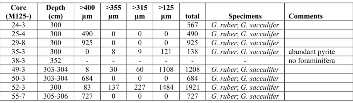
According to the cooperation agreement with Brazil, cores from the following stations will remain in Brazil for further scientific work: M125-24-3 (6.86 m), M125-35-3 (4.25 m), M125-49- 3 (7.16 m), M125-95-3 (10.4 m), and M125-108.3 (3.87 m).
Table 5.3 List of Gravity cores performed during METEOR Cruise M125.
Station
Location Date
Time Coordinates at Depth Recovery M125- (UTC) Lat. (S) Long. (W) Depth
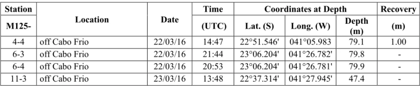
(m) (m) 4-4 off Cabo Frio 22/03/16 14:47 22°51.546' 041°05.983 79.1 1.00 6-3 off Cabo Frio 22/03/16 21:44 23°06.204' 041°26.782' 79.8 - 6-4 off Cabo Frio 22/03/16 20:53 23°06.204' 041°26.781' 79.9 - 11-3 off Cabo Frio 23/03/16 13:48 22°37.314' 041°27.945' 47.4 -
11-4 off Cabo Frio 23/03/16 14:16 22°37.315' 041°27.944' 48.2 - 14-3 off Cabo Frio 23/03/16 17:25 22°44.729' 041°31.078' 55.0 - 16-3 off Cabo Frio 24/03/16 09:57 22°54.930' 041°17.228' 69.0 1.40 18-2 off Cabo Frio 24/03/16 11:08 22°50.545' 041°21.337 60.5 - 19-3 off Cabo Frio 24/03/16 13:20 22°49.263' 041°27.735' 58.3 - 24-3 off Paraiba do Sul 25/03/16 15:45 21°55.930' 039°54.097 867.3 6.86 25-4 off Paraiba do Sul 25/03/16 21:38 21°51.534' 039°53.065' 960.1 6.52 29-8 off Paraiba do Sul 26/03/16 19:45 21°48.732' 039°32.031' 2019.4 6.82 34-2 off Paraiba do Sul 27/03/16 15:22 21°56.959' 039°56.112' 873.4 5.83 35-3 off Paraiba do Sul 27/03/16 18:33 21°53.605' 040°00.281' 430.4 4.25 35-4 off Paraiba do Sul 27/03/16 19:32 21°53.610' 040°00.281' 429.1 - 38-3 Rio Doce area 28/03/16 19:06 19°44.282' 039°50.737' 17.2 4.72 43-3 Rio Doce area 29/03/16 14:07 19°27.990' 039°26.332' 38.3 2.66 43-4 Rio Doce area 29/03/16 14:46 19°27.990' 039°26.333' 38.4 1.71 49-3 Slope E off Rio Doce 30/03/16 15:04 19°34.314' 038°40.544' 448.3 7.00 52-3 Slope E off Rio Doce98 30/03/16 23:18 19°35.946' 038°36.062' 644.2 8.41 67-4 Rio Jequitinhonha 03/04/16 12:34 15°16.965' 038°54.801' 29.0 4.97 77-3 Rio de Contas 05/04/16 14:12 14°23.200' 038°43.551' 1393.9 6.00 80-2 Rio de Contas 05/04/16 20:52 14°24.559' 038°53.307' 421.5 8.55 87-3 Rio de Contas 06/04/16 17:50 13°58.646' 038°52.116' 47.0 2.63 93-3 Slope off Rio Sao Francisco 08/04/17 14:01 10°52.414' 036°22.934' 955.20 6.56 95-3 Slope off Rio Sao Francisco 09/04/16 19:49 10°56.700' 036°12.342' 1896.6 10.40 102-4 Slope off Rio Sao Francisco 08/04/17 15:18 10°41.297' 036°26.540' 47.0 7.76 Table 5.4 List of Piston cores retrieved during METEOR Cruise M125.
Station Location Date Time Coordinates at Depth Recovery M125- (UTC) Lat. (S) Long. (W) Depth (m) (m)
25-3 off Paraiba do Sul 25/03/16 n/a n/a n/a n/a -
29-7 off Paraiba do Sul 26/03/16 n/a n/a n/a n/a -
50-3 Slope E off Rio Doce 30/03/16 19:15 19°42.620' 038°35.979' 903.7 13.16 55-7 Slope E off Rio Doce 31/03/16 18:49 20°21.807' 038°37.387' 1960.8 11.75 59-3 Slope E off Rio Doce 01/04/16 15:20 20°01.044' 038°50.859' 1763.1 7.99 61-2 Slope E off Rio Doce 01/04/16 20:00 20°02.372' 038°34.797' 1329.0 10.17 72-3 Rio de Contas 04/04/16 14:54 14°12.775' 038°38.529' 1738.4 13.43 73-3 Rio de Contas 04/04/16 21:12 14°10.608' 038°32.178' 2108.8 12.49 78-3 Rio de Contas 05/04/16 18:23 14°24.356' 038°50.068' 843.0 13.86 95-3 Slope off Rio Sao Francisco 08/04/16 19:49 10°56.700' 036°12.342' 1025.3 10.40 106-3 Slope off Rio Sao Francisco 10/04/16 15:22 10°42.605' 036°08.310' 1896.6 4.75
5.5.2.2 Van Veen Grab, Multicorer and Box Corer
(S. Voigt, E. Niedermeyer, S. Kusch, A. L. Albuquerque, B. Dias)
The Van Veen Grab (VVG) was used at Sections 1 at 4 stations and at Sections 5 and 7 at one station as a pilot survey at the shallow sites to test whether the sediment allowed for the operation of the multicorer (MUC). Surface samples from the VVG were taken to determine living (stained) benthic foraminifera, stable isotopes of living (stained) benthic foraminifera, total assemblage of planktic and benthic foraminifera, sedimentology, bulk sediment analyses, trace element geochemistry, and anthropogenic biomarkers.
The box corer (BC) was used at stations for which the MBPS indicated the presence of hardgrounds, where the deployment of the MUC might lead to damage of the gear. Sediments of
each box corer were sampled with one or two liners and stored at 4 °C. In addition surface samples were taken to determine living (stained) benthic foraminifera, stable isotopes of living (stained) benthic foraminifera, total assemblage of planktic and benthic foraminifera, sedimentology, bulk analyses, metals and trace elements geochemistry, and anthropogenic biomarkers.
Surface sampling was performed at 49 stations with the MUC equipped with 12 coring tubes (Table 5.5). Four tubes were completely sampled in 1 cm intervals for geochemical proxies in foraminifera (tube #1), for major, minor and trace element geochemistry, radiogenic isotopes and XRD analyses of the sediment (tube #2), for sediment petrography (grain size, magnetic properties) and heavy mineral composition (tube #3), and for biomarker analyses (tube #4).
Sediment surfaces (0-4 cm) were sampled from Tubes #9, #11, and #12 for purposes to-be- defined.
Tube #5 was destined to pore waters extraction by rhizones (stations M125-25-2, 31-2, 35-2, 39-2, 49-2, 50-2, 55-8, 67-3, 73-2, 77-2, 78-2, 82-3, 93-2, 100-4, 108-2) and remained sediments sliced in 1 cm intervals for analyses of stable isotopes in benthic foraminifera. When the recovery of sediments was not adequate for pore water analyses, the tube was completely sampled in 1 cm intervals and samples were destined for anthropogenic biomarker analyses (stations M125-5-4, 38-2, 48-2, 67-3, 83-2, 100-4, 112-3). Tubes #6 (210Pb analyses) and #8 (living stained forams) were also sliced completely in 1 cm intervals (stations M125-5-4, 25-2, 29-9, 35-2, 38-2, 39-2, 48- 2, 49-2, 50-2, 52-2, 55-8, 59-2, 61-3, 67-3, 72-2, 73-2, 77-2, 78-2, 80-3, 82-3, 93-2, 95-2, 102-2, 108-2, 112-3).
Tube #7 was sampled for compound-specific radiocarbon analysis of co-occurring terrestrial and marine biomarkers aiming at deciphering the timescales of organic matter deposition from land into the ocean (terrestrial residence time) and subsequent across-shelf transport.
Tube # 10 was sampled for the uppermost 4 cm for palynology and all other tubes were sampled for surface sediments by collecting the uppermost 2 cm. All samples, except for tube #7 were collected in Petri dishes and stored at 4 °C (tubes #1, 2, 3, 9, 10, 11, 12) or at -20°C (tube #4), respectively.
Samples from tubes #5, #6, and #8 were collected in plastic bags and stored at 4°C, except the uppermost 10 cm from tube #8 where samples were stored in plastic bottles with buffered Bengal Rose solution (1g/L, 4% formaldehyde). Tube #7 was sampled in 0-4 cm and 4-8 cm slices, transferred into pre-combusted glass jars, and stored frozen at -20°C.
Table 5.5 List of Multicores performed during METEOR Cruise M125.
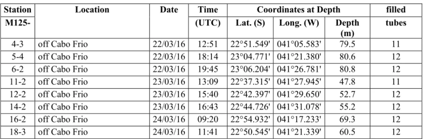
Station Location Date Time Coordinates at Depth filled
M125- (UTC) Lat. (S) Long. (W) Depth
(m) tubes 4-3 off Cabo Frio 22/03/16 12:51 22°51.549' 041°05.583' 79.5 11 5-4 off Cabo Frio 22/03/16 18:14 23°04.771' 041°21.380' 80.6 12 6-2 off Cabo Frio 22/03/16 19:45 23°06.204' 041°26.781' 80.8 12 11-2 off Cabo Frio 23/03/16 13:09 22°37.315' 041°27.945' 47.8 11 12-2 off Cabo Frio 23/03/16 15:40 22°42.397' 041°29.650' 52.7 12 14-2 off Cabo Frio 23/03/16 16:43 22°44.726' 041°31.078' 55.2 12 16-2 off Cabo Frio 24/03/16 09:20 22°54.932' 041°17.233' 69.3 12 18-3 off Cabo Frio 24/03/16 11:41 22°50.545' 041°21.339' 60.5 12