[INS][O]–¿o¡!–[/INS]–¿ceanic ¡!–[INS][P]–¿p¡!–[/INS]–¿lateau: Insights from IODP Expedition 324 and ¡!–[INS][R]–¿r¡!–[/INS]–¿ecent ¡!–[INS][G]–
¿g¡!–[/INS]–¿eophysical ¡!–[INS][C]–¿c¡!–[/INS]–¿ruises William W. Sager, Takashi Sano, J¨org Geldmacher
PII: S0012-8252(16)30098-8
DOI: doi:10.1016/j.earscirev.2016.05.011 Reference: EARTH 2264
To appear in: Earth Science Reviews Received date: 24 February 2015 Revised date: 3 May 2016 Accepted date: 26 May 2016
Please cite this article as: Sager, William W., Sano, Takashi, Geldmacher, J¨org, For- mation and ¡!–[INS][E]–¿e¡!–[/INS]–¿volution of Shatsky Rise ¡!–[INS][O]–¿o¡!–[/INS]–
¿ceanic ¡!–[INS][P]–¿p¡!–[/INS]–¿lateau: Insights from IODP Expedition 324 and ¡!–
[INS][R]–¿r¡!–[/INS]–¿ecent ¡!–[INS][G]–¿g¡!–[/INS]–¿eophysical ¡!–[INS][C]–¿c¡!–[/INS]–
¿ruises,Earth Science Reviews (2016), doi: 10.1016/j.earscirev.2016.05.011
This is a PDF file of an unedited manuscript that has been accepted for publication.
As a service to our customers we are providing this early version of the manuscript.
The manuscript will undergo copyediting, typesetting, and review of the resulting proof before it is published in its final form. Please note that during the production process errors may be discovered which could affect the content, and all legal disclaimers that apply to the journal pertain.
ACCEPTED MANUSCRIPT
Formation and Evolution of Shatsky Rise Oceanic Plateau: Insights from IODP Expedition 324 and Recent Geophysical Cruises
William W. Sager1,*, Takashi Sano2, and Jörg Geldmacher3
1Department of Earth and Atmospheric Sciences, University of Houston, Houston, TX 77204 USA; wwsager@uh.edu
2Department of Geology and Paleontology, National Museum of Nature and Science, 4-1-1 Amakubo, Tsukuba 305-0005, Japan; sano@kahaku.go.jp
3GEOMAR Helmholtz Center for Ocean Research Kiel, Wischhofstrasse 1-3, 24148 Kiel, Germany; jgeldmacher@geomar.de
*corresponding author
Key words:
Oceanic plateau
Large igneous provinces Mantle plume
Pacific Ocean Shatsky Rise Tamu Massif
Integrated Ocean Drilling Program Seismic reflection
Seismic refraction Geochemistry Geochronology Isotopic chemistry Plate tectonics
ACCEPTED MANUSCRIPT
Table of Contents 1. Introduction
1.1 Source Models: Plume Versus Plate
1.2 Geologic Background: Evolution of Shatsky Rise 1.3 Recent Shatsky Rise Research Programs
1.3.1 IODP Expedition 324 1.3.2 Seismic Exploration
1.3.3 Magnetic and Bathymetry Data
2. The Making of a LIP: New Observations on the Origin and Evolution of Shatsky Rise 2.1 IODP Expedition 324 Coring
2.1.1 Igneous Basement 2.1.2 Sedimentary Cover
2.2 Summit Depths and Subsidence
2.3 Geochronology and the Pattern of Volcanism 2.4 Seismic Imaging of Internal Structure
2.5 Secondary Volcanism Atop Shatsky Rise Edifices
2.6 Paleomagnetic Evidence for Eruption Timing and Paleolatitude 2.7 Magnetic Anomalies and Tectonic Evolution
2.8 Geochemical Clues About Magma Genesis and Evolution 2.8.1. Magma types
2.8.2 Transition of magma types with time 2.8.3 Melting conditions
2.8.4 Source temperature 2.8.5. Magmatic Evolution
2.9 Isotope Geochemistry: Fingerprints of Mantle Reservoirs 2.10. Igneous Rock Alteration
2.10.1. Low-temperature Hydrothermal Alteration
ACCEPTED MANUSCRIPT
2.10.2. High-temperature Hydrothermal Alteration 3. Discussion
3.1 Evolution of an Oceanic Plateau 3.1.1 Structure and Volcanic Style 3.1.2 Timing of Volcanism
3.1.3 Post Shield-Building Evolution 3.2 Shatsky Rise Origin
3.2.1 Geophysical Evidence
3.2.2 Geochronology and Eruption Duration 3.2.3 Geochemical and Isotopic Evidence 3.2.4 Plume and Plate?
4. Conclusions 5. References
ACCEPTED MANUSCRIPT
Abstract
Recent research from the Shatsky Rise in the western Pacific Ocean provides new insights on the formation and evolution of this oceanic plateau as well as tests of mantle models to explain anomalous large igneous province (LIP) volcanism. Recent Shatsky Rise studies cored the igneous pile (Integrated Ocean Drilling Program Expedition 324), imaged the interior with seismic refraction and multichannel seismic reflection data, and mapped magnetic anomalies adjacent to the plateau to provide new constraints on its tectonic history. Coring data show that Tamu Massif, the largest edifice within Shatsky Rise, is characterized by massive sheet flows, similar to flows caused by voluminous eruptions in continental flood basalts. Core data also indicate that the massive eruptions waned as the plateau evolved and smaller edifices were built. Seismic data show
intrabasement reflectors within Tamu Massif that indicate volcanism from its center, indicating that this is an enormous shield volcano with abnormally low flank slopes and thick crust (~30 km). Paleomagnetic data record minimal geomagnetic field variations, consistent with the inference of massive, rapid volcanism. Altogether, the physical picture indicates that Shatsky Rise was built by massive, rapid eruptions that formed enormous volcanoes. Geochronologic data support the previously inferred age progression, with the volcanic massifs formed along the trace of a triple junction starting from Tamu Massif and becoming progressively younger to the northeast. These data weaken support for rapid emplacement because they show that the last eruptions atop Tamu Massif
encompassed several million years between the final massive flows as well as a long hiatus of ~15 Myr until late stage eruptions that formed a summit ridge. They may also indicate that the last eruptions on Tamu and Ori massifs occurred while the triple
ACCEPTED MANUSCRIPT
junction was hundreds of kilometers distant. Furthermore, magnetic anomaly data indicate that the plate boundary reorganization associated with Shatsky Rise formation occurred several million years prior to the first Tamu Massif eruptions, suggesting plate boundary control of Shatsky Rise initiation. Geochemical and isotopic data show that Shatsky Rise rocks are variably enriched, with the majority of lavas being similar to mid- ocean ridge basalts (MORB). However, the data indicate deeper (>30 km) and higher partial degree of melting (15-23%) as compared with normal MORB. Melting models indicate that the magma experienced a mantle temperature anomaly, albeit only a small one (~50°C). Some lava compositions suggest the involvement of recycled subducted slab material. Recent investigations of Shatsky Rise initially envisaged a competition between two end-member models: the thermal plume head and the fertile mantle melting beneath plate extension (aka, plate model). Both hypotheses find support from new data and interpretations, but both do not fit some data. As a result, neither model can be
supported without reservation. Noting that most basaltic oceanic plateaus have formed at triple junctions or divergent plate boundaries, we suggest that this dichotomy is artificial.
Oceanic plateau volcanism is anomalous and focused at spreading ridges for reasons that are still poorly understood, mainly owing to uncertainties about mantle convection and geochemical reservoirs. Shatsky Rise investigations have vastly improved our
understanding of the formation of this oceanic plateau, but highlight that important work remains to understand the underlying nature of this volcanism.
ACCEPTED MANUSCRIPT
1. Introduction
Oceanic plateaus are mostly submarine LIPs, representing an immense transfer of magma from mantle to crust (Duncan and Richards, 1991; Coffin and Eldholm, 1994; Ernst and Buchan, 2001; Bryan and Ernst, 2008). Some oceanic plateaus, such as the enormous Ontong Java Plateau (OJP), appear to have formed rapidly (a few Myr) (Tarduno et al., 1991; Mahoney et al., 1993; Tejada et al., 1996; 2002), implying immense volcanic eruptions with global impact (Larson, 1991; Coffin and Eldholm, 1994). Others, such as Kerguelen-Broken Ridge or the Caribbean LIP, seemed to have assembled over longer time periods (Coffin et al., 2002;
Hoernle et al., 2004). Many of the plateaus scattered across the ocean basins were formed during the Cretaceous period, suggesting these eruptions were part of an episodic magmatic outbreak related to mantle convection (Larson, 1991). These inferences led to wide interest over the past two decades in investigating the origin and evolution of oceanic plateaus.
Despite increased research focus on these features, most remain poorly understood because they are immense and in remote locations, making sampling and study difficult and require the inference and testing of models from small data sets.
Shatsky Rise, located ~1500 km east of Japan in the northwest Pacific Ocean, is one of the largest oceanic plateaus with an area of ~5.3 x 10⁵ km2 (Sager et al., 1999; Zhang et al., 2016).
It consists of three major edifices, Tamu, Ori, and Shirshov massifs, in southwest-northeast alignment (Fig. 1). A low ridge, Papanin Ridge, extends to the northeast from Shirshov Massif and a cluster of several dozen seamounts, the Ojin Rise Seamounts, are scattered around Shirshov Massif and the area to its east (Fig. 1). Shatsky Rise is unique among large Mesozoic oceanic plateaus because geologic evidence suggests two competing hypotheses for plateau formation: the plume head and fertile mantle models (Sager, 2005) and it also contains
ACCEPTED MANUSCRIPT
magnetic anomalies to constrain contemporaneous spreading ridge locations. The former model envisages plateau formation resulting from a massive, thermal diapir arising from the deep mantle (Richards et al., 1989; Duncan and Richards, 1991; Coffin and Eldholm, 1994), whereas the latter explains excess volcanism by the melting of particularly fertile (lower melting point) upper mantle material owing to decompression caused by plate extension (Foulger, 2007; Anderson and Natland, 2014). This dichotomy and the interest that it sparked, led to several recent studies of Shatsky Rise, including coring of the igneous pile by Integrated Ocean Drilling Program (IODP) Expedition 324 (Sager et al., 2010; 2011a; 2011b), seismic imaging by the R/V Marcus G. Langseth (Korenaga and Sager, 2012; Sager et al., 2013; Zhang et al., 2015), and geophysical data collection by R/V Yokosuka (Nakanishi et al., 2015). In this review, we encapsulate results of these recent research projects and explore their ramifications regarding the formation and evolution of Shatsky Rise and by inference, other oceanic LIPs.
The various Shatsky Rise studies provide improved understanding of the life cycle of an oceanic plateau, but an unambiguous answer to the plume versus plate debate is not attained.
In part this results from the difficulty of inferring the depth of the source region from surface rock characteristics and the lack of consensus about mantle structure, geochemistry, and geodynamics. Instead, the strong evidence that Shatsky Rise volcanism was extraordinary coupled with the clear connection to mid-ocean ridge tectonics implies that the dichotomy may be miscast. The “end-member” models may, in fact, coexist in this setting.
1.1 Source Models: Plume Versus Plate
After the apparent success of the thermal plume model to explain linear seamount chains (Wilson, 1963; Morgan, 1971; 1972), this hypothesis became a popular mechanism to account for other examples of intraplate volcanism. It seemed an elegant mechanism to
ACCEPTED MANUSCRIPT
their large volumes, oceanic plateaus seem simply explained by a massive thermal plume and consistent with the emergence of a plume head, a large volume of buoyant hot material formed by the detachment of a nascent plume from a thermal boundary layer (Griffiths and Campbell, 1990; Campbell and Griffiths, 1990). This boundary layer is usually assumed to be the core- mantle boundary, where the thermal contrast could cause a large volume of material to detach from the boundary layer and rise through the mantle over a period of millions of years (Richards et al., 1989). If this plume head arrived at the base of continental lithosphere, spread out and underwent adiabatic melting, a continental flood basalt province (CFB) would be formed, and if beneath oceanic lithosphere, an oceanic plateau would be the result (Fig. 2) (Richards et al, 1989; Duncan and Richards, 1991). This hypotheses makes several important predictions: the buoyant plume head should cause significant (~1-3 km) initial uplift, the plume head should emplace a large volume of volcanic material in a short period of time (1-2 Myr), the magma source temperature and degree of melting should be higher than at spreading ridges or small seamounts, the rising plume should carry primitive lower mantle material to the surface, and the voluminous plume head should give way to a narrower, underlying, plume tail reflected by a decrease in eruption volume and spatial distribution with time (Campbell and Griffiths, 1992; Coffin and Eldholm, 1994; Campbell, 2005; 2007).
Because the plume head model predicts massive, rapid magma emplacement, it seemed a good way to explain Earth’s two largest oceanic LIPs, Ontong Java and Kerguelen plateaus, but evidence from Ocean Drilling Program (ODP) expeditions provided equivocal support.
Although ODP cores recovered thick subaerial basaltic lava flows, Kerguelen Plateau was found to have erupted over a much longer time period (~25 Ma) than expected (Coffin et al., 2002). Moreover, gneiss and granitoid rocks were cored at one site (Site 1137 on Elan Bank),
ACCEPTED MANUSCRIPT
a surprise implying that Kerguelen Plateau incorporated continental components (Coffin et al., 2002; Frey et al., 2003). In addition, the geochemistry of basalt samples indicates an interaction of the magma with these continental rocks (Neal et al., 2002), compromising their use for investigating the pristine mantle source. In contrast, construction of OJP appears to have occurred rapidly over a period of ~5 Myr centered at ~122 Ma (Neal et al., 1997; Tejada et al., 1996; 2002), emplacing a large volume of tholeiitic basalts with remarkably uniform geochemistry (Tejada et al., 2004) formed at high degrees of partial melting (~30%, Fitton and Godard, 2004; Herzberg, 2004), as would be expected of a plume head. However, OJP was mostly emplaced in a deep submarine environment, so its uplift was far less than predicted for active hotspots and its subsidence afterwards was anomalously small (Neal et al, 1997; Ito and Clift, 1998; Ito and Taira, 2000; Roberge et al., 2005), observations that are inconsistent with a simple, thermal plume model.
At about the same time, the scientific community began to question the wide application of the plume hypothesis, with some going as far as to say that thermal plumes from the deep mantle do not occur (Anderson, 1995; 2001; Foulger 2002; 2005; 2011; Anderson and Natland, 2014). An alternate mechanism was proposed for excess volcanism, with mantle melting caused by decompression of especially fertile mantle in places where plate boundaries or cracks in the lithosphere lower the hydrostatic pressure (Fig. 2) (Foulger and Natland, 2003;
Foulger et al., 2005a; Natland and Winterer, 2005; Korenaga, 2005; Foulger, 2007; Anderson and Natland, 2014). Although this model is currently not as specific in regards to surface expression as that of the thermal plume, it yields several implications: volcanism should be constrained by the geometry of the fertile source mantle and lithospheric extension zone and may not be emplaced within a limited radius as implied by a plume, the duration of volcanism
ACCEPTED MANUSCRIPT
is not controlled by the impact of a plume head, so it may be more time extensive, and volcanic material is entirely from the upper mantle.
Views of mantle plumes have also changed over time. Whereas plumes were initially thought to be narrow, columnar, upwelling jets caused by thermal buoyancy, initiated in the lower mantle or near the core-mantle boundary, modern views of mantle plumes are more complex. Plumes can be driven by compositional contrast relative to the host mantle as well as thermal contrast, a so-called thermochemical plume (Tackley, 1998; Farnetani and Samuel, 2005). This allows a plume to occur without a large thermal contrast and to cause only negligible surface uplift (Dannberg and Sobolev, 2014). Thermochemical plumes may also have more complex shapes than the simple, narrow columnar form or may arise from other depths in the mantle, such as the transition zone (Tackley, 1998; Davaille, 1999; Farnetani and Samuel, 2005; Kumagai et al., 2008). Modeling studies also suggest that chemical heterogeneities from subducting slabs and primitive material can be preserved in thermochemical piles at the base of the mantle and that plumes can carry this heterogeneity back to the surface (Farnetani et al., 2002), producing rocks with varied geochemical signatures that may change over time or resulting in spatially zoned hot spot tracks (Hoernle et al. 2000; 2015; Abouchami et al., 2005). Seismic tomography studies have sought to find and trace narrow plumes from the deep mantle, but have not delivered a clear answer, perhaps because seismic tomography cannot resolve such features (e.g., Nolet et al., 2007; Hwang et al., 2011). Studies by Montelli et al. (2004, 2006) perhaps come closest to the original idea of mantle plumes, suggesting sub-vertical, low-velocity zones beneath a large number of known hotspots, with many of such features observable through a significant portions of the mantle.
In contrast, a recent model (French and Romanowicz, 2015) displays broad low velocity zones
ACCEPTED MANUSCRIPT
beneath many hotspots but unclear connections through the upper mantle. Thus, despite improvements in tomography, the impact of these studies remains unclear.
1.2 Geologic Background: Evolution of Shatsky Rise
Shatsky Rise began to form near the equator, in the middle of the Pacific Ocean, near the time of the Jurassic-Cretaceous boundary (Sager et al., 1988; 1999; Nakanishi et al., 1999;
Mahoney et al., 2005). The plateau sits at the confluence of the southwest-northeast trending Japanese magnetic lineations and the northwest-southeast trending Hawaiian magnetic lineations (Fig. 2), implying that it formed at a triple junction (Hilde et al., 1976; Sager et al., 1988). Although there is no preserved record of the third plate boundary, because the formerly adjacent Izanagi and Farallon plates have been subducted (Woods and Davies, 1982), kinematic stability implies that the triple junction probably had a ridge-ridge-ridge geometry (Sager et al., 1988; Nakanishi et al., 1999). Available age evidence and gravity anomalies also indicate that Shatsky Rise formed near the triple junction. A radiometric age of 144.6 ±0.8 Ma for igneous rocks recovered at ODP Site 1213 on the south flank of Tamu Massif (Mahoney et al., 2005) is approximately the same as magnetic chron M19 (Sager, 2005), which transects the north flank of the massif. Thus, the edifice top is approximately the same age as the lithosphere beneath it. Although precise radiometric ages were hitherto not available for the other parts of the plateau, gravity anomalies indicate that the entire plateau is in complete Airy isostatic compensation, implying that it formed near the spreading ridges (Sandwell and MacKenzie, 1989). Because the magnetic lineations become progressively younger to the northeast, a similar age progression for the volcanic edifices is implied (Sager et al., 1999;
Nakanishi et al., 1999).
ACCEPTED MANUSCRIPT
Magnetic lineations imply that the triple junction was migrating northwest relative to the Pacific plate prior to M21, when Shatsky Rise began to form (Fig. 3; Sager et al., 1988).
Tamu Massif formed first, near the time of the Jurassic-Cretaceous boundary, and the triple junction simultaneously jumped NE ~800 km to the location of the massif (Sager et al., 1988;
1999). At the same time, the spreading direction changed ~24° on the Pacific-Izanagi ridge (Japanese magnetic lineations) and one or more microplates were created (Sager et al., 1988;
1999; Nakanishi et al, 1989; 1999). Because Shatsky Rise formed at a spreading-ridge triple junction, some authors believe that parts may have been rifted away by the adjacent plates and accreted at Pacific-rim subduction zones as the Izanagi and Farallon plates were subducted (Sager et al., 1988; Larson, 1991; Kimura et al., 1994; Ichiyama et al., 2014). The magnetic lineations indicate that the triple junction migrated northeast, along the axis of Shatsky Rise (Fig. 3) as younger edifices (Ori and Shishov massifs and Papanin Ridge) were emplaced (Sager et al., 1988; 1999). During this time, the northeastward direction of triple junction migration was not that predicted by plate kinematics (it should have been northwest) and the triple junction jumped northeastward at least 9 times (Sager et al., 1988; Nakanishi et al., 1999).
These anomalies imply that something other than plate kinematics dictated the triple junction location. After about M4 time, the triple junction no longer followed Papanin Ridge (Nakanishi et al., 1999). Subsequently, this ridge appears to bend to the SE and may connect with Hess Rise (Sager et al., 1999). Bercovici and Mahoney (1994) hypothesized the two rises are related as being products of a double plume head.
Although Shatsky Rise probably stayed near the equator during its formation (Sager et al., 2015), afterwards it rode the Pacific plate ~35° northward from the equator to its present location (Sager, 2007). Soon after emplacement, it began collecting carbonate pelagic
ACCEPTED MANUSCRIPT
sediments and accumulated a thick cap during the Mesozoic as it lay beneath the equatorial high productivity zone (Sliter and Brown, 1993). Because of the abundance of siliceous sedimentation within the high productivity zone, the Cretaceous carbonate sediment section later became pervasively infested with chert layers and nodules, frustrating scientific coring of these sediments (e.g., Moberly and Larson, 1975). After the plateau drifted away from the equator, a drape of Cenozoic pelagic sediments topped the sedimentary section (Sliter and Brown, 1993; Bralower et al., 2006).
1.3 Recent Shatsky Rise Research Programs 1.3.1 IODP Expedition 324
IODP Expedition 324 took place during 2009 and had an objective of extensive coring of igneous rock from Shatsky Rise (Expedition 324 Scientists, 2010a). Prior to Expedition 324, igneous basement was cored only once, at Site 1213 (Fig. 2) during ODP Leg 198, where a 47- m basalt section was penetrated (Shipboard Scientific Party, 2002). Although dredged samples had previously been retrieved from Shatsky Rise (Sager et al., 1999), almost all were highly altered and unsuitable for the geochemical and geochronological studies critical to
understanding the origin of the plateau. During Expedition 324, five sites were cored (Figs. 2, 4), two on Tamu Massif (Sites U1347 and U1348), two on Ori Massif (Sites U1349 and U1350), and one on Shirshov Massif (Site U1346). Site U1346 penetrated a 52.6-m section of mostly pillow lavas (Fig. 4) from the summit platform of Shirshov Massif (Expedition 324 Scientists, 2010b). Site U1347, on the southeastern upper flank of Tamu Massif, cored a 159.9-m igneous section consisting of alternating massive flows and pillow lavas (Fig. 4;
Expedition 324 Scientists, 2010c), whereas Site U1348, on a basement high on the Tamu Massif north flank, recovered ~120 m of volcaniclastics, but no lava flows (Expedition 324 Scientists, 2010d). Site U1349, situated atop a summit ridge on Ori Massif, penetrated 85.3 m
ACCEPTED MANUSCRIPT
of thin massive flows (Expedition 324 Scientists, 2010e) and Site U1350, on the east flank of the same edifice, cored 172.7 m of igneous basement, consisting mostly of pillow units (Fig. 4;
Expedition 324 Scientists, 2010f).
Because the Cretaceous sedimentary cap on Shatsky Rise comprises a relatively well- known succession of pelagic chalk and limestone and recovery is poor owing to the pervasive occurrence of chert, sediment coring in all Expedition 324 holes was not initiated until near basement. Nevertheless, basal sediment layers other than chert and chalk were recovered at all sites except for U1350 (Figs. 4, 5). At Site U1346, a 19.7-m succession of basalt-limestone breccia was found to overlie turbiditic volcaniclastic sediments situated atop limestones and calcareous mudstones (Expedition 324 Scientists, 2010b). Site U1347 produced a 77-m section of limestone and calcareous sandstone with volcaniclastics atop radiolarian-rich siltstones and sandstones with volcaniclastics (Expedition 324 Scientists, 2010c; Hermann and Stroncik, 2013). Site U1348 yielded several layers of bioclastic sandstone between volcaniclastic units (Expedition 324 Scientists, 2010d). A 29.8-m section of claystone and sandstone overlying sandstone, breccia, and conglomerate was cored at Site U1349 (Expedition 324 Scientists, 2010d). Because so few other drill sites have penetrated to igneous basement, Expedition 324 provided the first extensive sampling of supra-basement sediments on Shatsky Rise and showed that most summit sites were in shallow water shortly after volcanic activity concluded (Expedition 324 Scientists, 2010a).
1.3.2 Seismic Exploration
During cruises in 2010 (MGL1002) and 2012 (MGL1206), the R/V Marcus G. Langseth collected seismic refraction and reflection data, mainly over Tamu Massif (Fig. 2). Refraction data were collected on a 420-km transect crossing the summit of Tamu Massif and passing
ACCEPTED MANUSCRIPT
over Site U1347. Data were recorded by 21 ocean bottom seismometers and these data were used to construct a tomographic velocity section (Korenaga and Sager, 2012). A total of ~3350 km of 2D multichannel seismic (MCS) reflection profiles were collected over southern Shatsky Rise using a 36-airgun array as a sound source and a 6-km, 468 channel streamer (hydrophone array) to record the seismic waves (Zhang et al., 2015). The seismic lines were oriented to provide four cross-axis profiles across Tamu Massif, one along the axis of the massif, and another over Ori Massif (Fig. 2). These lines crossed all of the basement drill sites, except for Site U1346, allowing a comparison between seismic and coring data (Zhang et al., 2015).
1.3.3 Magnetic and Bathymetry Data
Bathymetry and magnetic data were collected on transit tracks between sites on Expedition 324 (Kang and Sager, 2010). Multibeam bathymetry data were collected on all track lines run by the R/V Marcus G. Langseth. Despite recent multibeam data acquisition, only about 20%
of Tamu Massif has been covered by these high-resolution data, so most data occur along isolated tracks, except where surveys have concentrated on the summit. In addition, a cruise by the JAMSTEC (Japan Agency for Marine Technology) vessel R/V Yokosuka (cruise YK08- 09) during 2008 collected magnetic, gravity, and multibeam bathymetry data on the southern margin of Tamu Massif, in an effort to elucidate the initial formation of the plateau (Nakanishi et al., 2015).
2. The Making of a LIP: New Observations on the Origin and Evolution of Shatsky Rise
2.1 IODP Expedition 324 Coring 2.1.1 Igneous Basement
Prior to IODP Expedition 324, little was known about the volcanic basement of Shatsky Rise. Although it was clear from dredging that the plateau basement was igneous and of
ACCEPTED MANUSCRIPT
basaltic composition (Kashintsev and Suzymov, 1981; Sager et al., 1999), most recovered samples were highly altered and often unsuitable for geochemical or geochronological studies.
ODP Leg 198 cored a 47-m section of basaltic rock at Site 1213 and the three recovered igneous units were interpreted as diabase sills, i. e., intrusives possibly erupted into the earliest Cretaceous sedimentary layers (Shipboard Scientific Party, 2002). Samples from these cores, produced the first reliable radiometric date for Shatsky Rise, 144.6 ±0.8 Ma (Mahoney et al., 2005), proving that the basement of Tamu Massif was of Late Jurassic-Early Cretaceous age, as had been interpreted from the earliest Cretaceous sediments cored on Deep Sea Drilling Project (DSDP) Leg 32 (Shipboard Scientific Party, 1975). Furthermore, geochemical studies of these same samples concluded that their isotopic signatures were very much like mid-ocean ridge basalt (MORB), deepening the mystery of the Shatsky Rise magma source (Mahoney et al., 2005).
Expedition 324 cores provide a wealth of information about the volcanism that created Shatsky Rise. The signal characteristic of cores recovered on the expedition is the dichotomy between Tamu Massif and the smaller edifices, Ori and Shirshov massifs. Coring at Site U1347 recovered pillow lavas and thick, massive flows up to ~23 m in thickness (Expedition 324 Scientists, 2010a; Sager et al., 2011a; 2011b). The pillow lavas are typical of submarine volcanism at modest effusion rates (e.g., Ballard et al., 1979; McClinton et al., 2013), but the massive flows are interpreted as analogous to “massive sheet flows” mapped in continental flood basalt provinces (Self et al., 1997). They indicate highly effusive volcanism and are formed by inflation as copious lava flows into the chilled skin formed by contact with the surrounding environment (Self et al., 1997). Such flows are capable of flowing long distances and the necessary ingredients are highly fluid lava, produced at prodigious rates, shielded from
ACCEPTED MANUSCRIPT
cooling by a thick, insulating skin (Kesthelyi and Self, 1998). As the Site U1347 section consists of two sequences of massive flows separated by pillow lavas (Fig. 4), two pulses of effusive volcanism with an intervening period of lesser output were interpreted (Expedition 324 Scientists, 2010a, c).
After re-examining the Site 1213 igneous cores, Expedition 324 scientists re-interpreted the three igneous units as massive flows similar to those at Site U1347 (Koppers et al., 2010).
With the entire Site 1213 section being made up of massive flows and 66% of the Site U1347 section also consisting of these flows (Sager et al., 2011b), the implication is that Tamu Massif was formed mainly by massive sheet flows that erupted large volumes of lava and probably flowed for long distances. Interestingly, the Site U1347 section is quite similar to that cored at Site 1185 on OJP, which is also characterized by massive flows (Shipboard Scientific Party, 2001). Evidently, the two large plateaus Tamu Massif and OJP shared similar eruption mechanisms.
A surprise finding within the lava flows of Site U1347 are a number of thick sedimentary layers, unexpected because they imply the passage of time, contrary to the picture of rapid, massive volcanism. Four sedimentary beds were recovered within the basement section of the U1347 cores (Sager et al., 2010), two between the uppermost massive flows (at ~187 and ~204 mbsf) and the other two between pillow units (at ~259 and ~278 mbsf). In Figure 4, only the layer at ~204 mbsf appears to be thick because the graphic lithology diagram is based on recovered rock, which was small for three of these units. Analyses of wireline log data indicate that the upper two sedimentary units are ~9-10 m in thickness and the lower two are
~5 m thick (Fig. 4), suggesting long periods of volcanic quiescence (Tominaga et al., 2014).
Although recovered sedimentary rocks from the uppermost layer show signs of soft-sediment
ACCEPTED MANUSCRIPT
deformation, as could occur from mass wasting, the others do not. Moreover, most of these units contain radiolarian-bearing rocks and one (at ~259 mbsf) contains limestone, both implying pelagic sedimentation (Expedition 324 Scientists, 2010c). Unfortunately, it is impossible to constrain the duration of sedimentation, but the implication is that significant time may have elapsed between lava flows, especially the upper massive flows.
Another surprise from Tamu Massif was the coring of a ~120 m volcaniclastic section from Site U1348. This hole is situated atop a large (~30 km across) basement high on the north flank of the massif. The cored section consists of three layers of volcaniclastics, interbedded with bioclastic sandstones (Fig. 4). The volcaniclastic layers probably represent individual volcanic eruptions, with the sedimentary intervals implying quiescence. Although volcaniclastics can be formed in deep water (Gill et al., 1990; Davis and Clague, 2003; Eissen et al., 2003), shallow water formation is indicated for the upper volcaniclastic units (Units IIIa, IIIc) because fossils of shallow water fauna are found within the section, particularly in the bioclastic sandstone overlying and underlying the volcaniclastics (Units II, IV) (Expedition 324 Scientists, 2010d). Moreover, the presence of reddish scoria throughout the interbedded sandstone unit (Unit IIIb) may indicate subaerial eruption. In contrast, the lower volcaniclastics (Units V, VI) are a mixture of in situ and re-deposited hyaloclastite that are deposited in at depths below wave base but less than ~500 m. A shallow water environment is also supported by dissolved volatiles (CO2 and H2O) from fresh hyaloclastite samples, which give water-depth estimates of 287 m (Shimizu et al., 2013). Although coring at Site U1348 did not penetrate deeply (~120 m into basement), they suggest that the large cone-like feature at whose summit the site penetrated (Expedition 324 Scientists, 2010d) may thus be a
ACCEPTED MANUSCRIPT
volcaniclastic feature. If true, this inference suggests that volcaniclastic deposits may be voluminous in some spots
Similar findings come from other LIPs, suggesting that volcaniclastics are common in the late stages of submarine basaltic eruptions and typically occur in shallow water. At OJP, Site 1184 produced shallow water volcaniclastics (Thordarson, 2004) whereas the recovered lava flows from other sites were emplaced in deep water (Neal et al., 1997; Fitton and Godard, 2004). Basal volcaniclastic sediments were cored at Manihiki Plateau and interpreted as phreatomagmatic products of shallow water eruptions (Jackson and Schlanger, 1976). This plateau is part of the Ontong Java Nui LIP (Ontong Java plus Manihiki and Hikurangi plateaus;
Taylor, 2006; Chandler et al., 2012; Hochmuth et al., 2015), implying that such deposits were widespread in the formation of this LIP. Similarly, phreatomagmatic volcaniclastics were recovered from several ODP Leg 183 sites at Kerguelen Plateau (Coffin et al., 2000). ODP Leg 183 scientists reported volcaniclastic successions overlying basalt lava flows are minimally reworked pyroclastic flow deposits that erupted under subaerial and shallow marine environments (Shipboard Scientific Party, 2000; Wallace, 2002). Moreover, similar basaltic volcaniclastic intervals have been found on numerous other oceanic plateaus (e.g., Ross et al., 2005).
Igneous rocks recovered on Ori and Shirshov massifs contrast with those from Tamu Massif. Pillow lavas are more common and massive flows are thinner. At Site U1350 on the Ori Massif flank, pillow lavas make up ~86% of the cored section and at Site U1346 on Shirshov Massif, the section is almost entirely pillow lavas (Fig. 4). In the Site U1349 igneous section, from the Ori Massif summit, all recovered lava flows are massive, but they are much thinner than those found on Tamu Massif. The picture provided by Expedition 324 cores is
ACCEPTED MANUSCRIPT
that Tamu Massif was built by voluminous, effusive eruptions, whereas the smaller edifices Ori and Shirshov, were constructed by less effusive volcanism (Sager et al., 2011a; 2011b). This finding is consistent with the fact that Ori and Shirshov massifs are much smaller in volume (Sager et al., 1999), indicating the waning of the Shatsky Rise melting anomaly (Sager et al., 2011a; 2011b).
2.1.2 Sedimentary Cover
Calcareous sediments are often well preserved when deposited above the carbonate compensation depth on top of oceanic swells or plateaus. As a result, the thick successions of sediments atop Shatsky Rise edifices have been the target of previous drilling expeditions, most notably DSDP Leg 32 (Moberly and Larson, 1975) and ODP Leg 198 (Bralower et al., 2006). As recovering sediments was not a primary objective of Expedition 324, basement drill sites were chosen at locations with thin sediment cover and only hard rock coring techniques were used, which led to lesser core recovery and more disturbance than would have occurred with coring techniques adapted for sediments. Moreover, the chert-infested carbonate sediments of the Cretaceous sediment cap were known to produce exceedingly poor recovery (e.g., Moberly and Larson, 1975), so sediments shallower than ~50-80 m above the igneous basement were not cored on Expedition 324. Nevertheless, a variety of basal sediment types were recovered from the five sites on Shatsky Rise (Expedition 324 Scientists, 2010a). As with previous coring, only indurated chert fragments were recovered from the Cretaceous chalk and limestone sections at each site. A rare exception is a short (~1.4 m) interval of pelagic ooze recovered at Site U1348, recording the rarely-preserved Santonian-Campanian transition (Ando et al., 2013). This section proves that poorly-consolidated ooze and chalk layers are indeed present deep within the pelagic cap, an assertion often made but rarely proved owing to poor core recovery. Prior to Expedition 324, recovery of a significant amount of non-pelagic
ACCEPTED MANUSCRIPT
sediments had not been accomplished. Basal sediments retrieved during Expedition 324 range from bioclastic limestones and radiolarian-rich siliciclastics to volcaniclastic sequences (Fig. 5), indicating a complex sedimentation and subsidence history.
Although the sediment layers immediately overlying igneous basement did not always contain fossils that provide precise age constraints or ranges, an Early Cretaceous age of the sediments covering the volcanic rocks was confirmed at all drill sites (Expedition 324 Scientists, 2010a). Where ages were constrained in the basal sedimentary units, they fall in the following ranges: 133 to 140 Ma for Tamu Massif Site U1347, 100 to 127 Ma for Ori Massif Site U1349, and 128 to 142 Ma for Shirshov Massif Site U1346 (Expedition 324 Scientists, 2010a), thus providing minimum ages for the magmatic edifices below. At Tamu Massif flank Site U1348, where no basement was reached, the lowermost recovered microfossils indicate an age of >120 Ma for the edifice below (Expedition 324 Scientists, 2010d). In addition, the Sr isotopic composition of secondary calcite carbonate veins formed within fractures in the recovered lavas was used to constrain precipitation ages by correlation with the global seawater Sr isotopic evolution curve. Results from samples recovered at Sites U1347, U1349, and U1346 are consistent with minimum formation ages for the volcanic host rocks of 143, 134, and 128 Ma, respectively (Li et al., 2015). Sediment ages thus are consistent with the limited, newly obtained radiometric ages (Heaton and Koppers, 2014; Geldmacher et al., 2014; Tejada et al., in press, see Section 2.3 “Geochronlogy and Pattern of Volcanism”), support the postulated age decrease of the Shatsky Rise edifices from southwest to northeast as indicated by the magnetic lineations (Nakanishi et al., 1999), and confirm that Shatsky Rise edifices were built on young seafloor (Sager et al., 1999).
ACCEPTED MANUSCRIPT
Volcaniclastic sediments above the igneous basement at Site U1347 contain a neritic (<200 m water depths) assemblage of benthic foraminifera and bedding structures indicative of shallow water conditions (shoreface environment above wave base) (Expedition 324 Scientists, 2010c). Because the nearby top of the volcano (shallowest basement on seismic profiles) is
800 m shallower than these sediments (Expedition 324 Scientists, 2010a; Sager et al., 2011), the Tamu Massif summit may have been emergent. At Site U1349, a yellow-red clay layer of weathered basalt fragments at the top of the igneous basement is interpreted as paleosol (Expedition 324 Scientists, 2010e), implying subaerial exposure under tropical conditions (Expedition 324 Scientists, 2010a). In contrast, a shallow submarine depositional environment is indicated by oolitic limestone cored between lava flows 10 m below the paleosol. Thus, the basement surface at Site U1349 must have been close to sea level. Shallow water depths are less precisely constrained for the basal sediments at Site U1346 on the Shirshov Massif summit; however, abundant shell fragments and a neritic benthic foramineferal assemblage indicate a depositional environment of <500m (Expedition 324 Scientists, 2010b). Taken as a whole, Expedition 324 sediments indicate that Shatsky Rise edifice summits were near sea level, but there is also no evidence for significant emergence.
2.2 Summit Depths and Subsidence
Other data pertaining to water depth give similar indications as the basal sediments, implying that Shatsky Rise edifice tops were in shallow water but not highly emergent.
Seismic sections over the summit of Tamu Massif show no apparent truncation owing to wave action (Sager et al., 2013; Zhang et al., 2015), implying that the igneous pedestal was never greatly exposed. Seismic profiles over Ori and Shirshov massifs give similar indications (Zhang et al., 2015).
ACCEPTED MANUSCRIPT
Backtracking of thermal subsidence for Expedition 324 drill sites brings all of the summit and near-summit sites to near sea level (Fig. 6), consistent with the interpretations from basal sediments (Expedition 324 Scientists, 2010a). Because the Stein and Stein (1992) cooling boundary layer (plate) model predicts less subsidence than the Parsons and Sclater (1977) half-space cooling model, the former predicts initial depths that were slightly submerged, whereas the latter indicates slightly emergent depths (Fig. 6). Nevertheless, both models imply that the present depths of Expedition 324 site basement interfaces are consistent with the inferences from sediments indicating depths near or slightly below sea level.
Additional evidence of emplacement depth comes from measurements of volatiles (CO2, H2O) in volcanic glasses from Expedition 324 cores measured by Shimizu et al. (2013). These data indicate that all sites were submarine, but emplaced within 1 km of sea level (U1347 - 943 m ±103 m; U1348 - 381 m ±48 m; U1350 - 767 m ±108 m; U1346 - 781 m ±76 m) and that implied subsidence was between 2500-3300 m. These subsidence values are greater by ~1 km than those estimated previously using fossil paleodepth estimates from sediments recovered at DSDP Site 305 on Tamu Massif (Ito and Clift, 1998), but presumably this difference can be attributed to several factors, including coring not reaching basal sediments at Site 305 and inexact fossil paleodepth estimates. Interestingly the volatile-derived subsidence data also show a progressive increase in subsidence from the center of Tamu Massif (Site U1347) to Ori Massif (Sites U1349, U1350), which may indicate that a buoyant mass retarded the subsidence of the Tamu Massif center (Shimizu et al., 2013). The authors also modeled uplift from isostatic compensation and thermal buoyancy of the mantle and concluded that no thermal component is required if Tamu Massif formed at the ridge crest (i.e., zero age crust) but that a model with the edifice formed on 5 Ma crust and with thinner crust than observed (i.e., ~20 km
ACCEPTED MANUSCRIPT
rather than the ~30 km from refraction measurements (Korenaga and Sager, 2012)) can also fit the observed plateau elevation.
Overall, data on summit elevations of Shatsky Rise edifices place it near sea level but with no clear evidence of significant emergence. This fits Shatsky Rise between Kerguelen and Ontong Java plateaus in its emplacement depth. The former was largely emplaced subaerially (Coffin, 1992; Frey et al., 2003) whereas the latter was mostly emplaced >1 km below sea level (Michael, 1999; Fitton et al., 2004; Roberge et al., 2005). That Shatsky Rise was never highly emergent implies that its evolution was different than Iceland, a ridge- centered hotspot and possible mantle plume, which has an elevation of ~ 2 km (Ito et al., 2003).
2.3 Geochronology and the Pattern of Volcanism
Prior to Expedition 324, only one reliable radiometric date existed for Shatsky Rise, the 144.6 ±0.8 Ma date derived from Site 1213 samples (Mahoney et al., 2005). Ages for the igneous edifices were otherwise extrapolated from the ages of the sediments near the bottom of the sediment cap (Moberly and Larson, 1975) or by inference from magnetic lineations (Nakanishi et al., 1999) and gravity anomalies (Sandwell and MacKenzie, 1989). Research related to Expedition 324 has produced the first radiometric date for Ori Massif, ~134 Ma (Heaton and Koppers, 2014). If this date, from Site U1350 on the east flank, is accurate and does not reflect late-stage volcanism, it indicates a significant gap between the formation of the upper carapace of Ori Massif and the surrounding lithosphere. The current geomagnetic polarity time scale assigns 134 Ma to anomaly M10 (Gradstein et al., 2012; all magnetic anomaly ages herein use this time scale). By this time, magnetic lineations show that the triple junction was ~600 km farther northeast (Figs. 2, 3). Taken at face value, this difference implies off-ridge formation for Ori Massif, but this edifice contains magnetic anomalies that
ACCEPTED MANUSCRIPT
are parallel to the nearby seafloor anomalies (see Section 2.7, “Magnetic Anomalies and Tectonic Evolution”), indicating formation at the ridge. An alternative explanation is a several-million-year gap between the eruption of last flows and the main shield building flows below, similar to findings at Tamu Massif (see below).
New radiometric dates also give important insights about the construction of Tamu Massif. The lower part of the recovered Site U1347 lava flow section is dated at ~143-145 Ma, nearly equal to that reported by Mahoney et al. (2005) for Site 1213 (Heaton and Koppers, 2014; Geldmacher et al., 2014). A significant age gap (~3 Myr from Heaton and Koppers (2014) and ~10 Myr from Geldmacher et al. (2014)) exists between the upper and lower massive lava flows within the U1347 section. What is more, recalibration of the 144.6 Ma date from Site 1213 shifts it to an age near that of the upper flows from Site U1347 (A. Koppers, personal communication, 2014). This surprising result implies that Tamu Massif was quiescent for at least several million years before another massive sheet flow complex was emplaced, capping the volcano at Sites 1213 and U1347. In a similar vein, the new radiometric date of ~129 Ma for Toronto Ridge (Tejada et al., in press), suggests that this ridge erupted ~15 Myr after the last large eruptions of Tamu Massif.
2.4 Seismic Imaging of Internal Structure
Although illuminating, Expedition 324 results suffer from being a small number of spot samples from a large plateau with uncertain extrapolation to the entire plateau. Seismic imaging carried out by the R/V Marcus G. Langseth, provided a crucial data set for integrating these results into the broad-scale structure of the plateau.
A tomographic seismic refraction cross-section across Tamu Massif imaged the Moho for the first time beneath the thickest part of the plateau, revealing a maximum crustal
ACCEPTED MANUSCRIPT
thickness of ~30 km (Fig. 7; Korenaga and Sager, 2012). The observed thickness is consistent with complete Airy isostasy (Zhang et al., 2016). At the center of Tamu Massif, the ~3 km height (above the surrounding abyssal seafloor) is supported by ~18 km of isostatic root.
Multichannel seismic transects also show seismic Moho beneath the distal flanks of the plateau, with the observed crustal thicknesses also consistent with Airy isostasy (Zhang et al. 2016).
Complete Airy isostatic compensation explains the small, observed gravity anomaly values over the plateau. These observations indicate that most of the bulk of Tamu Massif lies within the mantle.
The refraction data provide two important clues about Tamu Massif crustal structure.
No high-velocity lower layer was revealed at the base of the massif crust (Fig. 7), as is sometimes interpreted as magmatic underplating (e.g., Ito and Clift, 1998). In addition, these results also revealed a negative correlation between lower crustal seismic velocity and crustal thickness (Korenaga and Sager, 2012). Because hotter mantle temperature should cause greater melting (and thus greater crustal thickness), this finding can be taken as evidence that the source mantle was cool instead (Korenaga and Sager, 2012). This interpretation depends on the entire crustal column being formed at the same time (Korenaga et al., 2002), which may not be true if the volcano was built by long-traveled lava flows from the central region (Sager et al., 2013).
Multichannel seismic profiles from the R/V Marcus G. Langseth cruises display deep penetration into igneous basement, revealing faint, sub-parallel intrabasement reflectors (Figs.
8, 9) at two-way travel times of up to 2.0-2.5 seconds below the basement horizon (Sager et al., 2013; Zhang et al., 2015). Assuming an average seismic wave velocity of ~4 kms-1 in the upper crust (Korenaga and Sager, 2012), such travel-times imply depths of ~4-5 km within the
ACCEPTED MANUSCRIPT
plateau. Comparison of velocity and density log data from Expedition 324 boreholes (Sites U1347, U1348) with the seismic data shows that the intrabasement reflectors result from acoustic impedance contrasts between groups of lava flows with different characteristics, such as the alternations of massive and pillow flows cored at Site U1347 (Zhang et al., 2015). A similar seismic expression is observed in multichannel seismic profiles collected from Ontong Java Plateau (Inoue et al., 2008) and Manihiki Plateau (Pietsch and Uenzelmann-Neben, 2015).
At Site U1347, some reflectors resulted also from the thick sediment layers between lava flows (Zhang et al., 2015). Both findings imply that the intrabasement reflectors trace the surfaces of lava flows, so their geometry can be used to infer the lava-layer-cake structure within the edifice.
The intrabasement reflectors are often weak and discontinuous, a result of the small acoustic contrast between igneous units and the rough nature of the interfaces (Figs. 8, 9).
However, these horizons are frequently observed for 10-15 km and can be readily connected into longer, piecewise continuous reflectors (Sager et al., 2013; Zhang et al., 2015; Vuong et al., 2015). The overall pattern of intrabasement reflectors is subparallel and follows the basement interface (Figs. 8, 9), implying lava flows descending from the summit to the flanks (Sager et al., 2013; Zhang et al., 2015). In fact, no matter what direction the seismic line crosses the Tamu summit, the same pattern is seen and no large secondary source of volcanism is observed (Sager et al., 2013; Zhang et al., 2015). This observation can be used to infer that Tamu Massif is an immense, single, shield volcano (the largest known single volcano) built by eruptions mainly from its center (Sager et al., 2013). Only a single deep-penetration multichannel seismic line was collected over the center of Ori Massif. This profile suggests that Ori Massif has a similar structure; although, another profile over the Ori Massif west flank suggests
ACCEPTED MANUSCRIPT
internal complexity and hints at more than one volcanic center, similar to other large volcanic complexes, such as Hawaii (Zhang et al., 2015).
An interesting observation from the deepest reflections inside Tamu Massif is that the apparent dip of the intrabasement reflectors changes little with depth (Fig. 8; Zhang et al., 2015). If lavas emanated from the center and were preferentially deposited there, the center should have subsided owing to isostatic adjustment, causing reflectors to dip inward towards the center, similar to seaward dipping reflectors (Mutter et al., 1982; Mutter, 1985; Planke et al., 2000) – but this is not observed. This finding implies that the edifice was constructed in complete isostatic balance.
The multichannel seismic profiles also show the depth of Moho beneath the deep parts of the plateau between edifices (Zhang et al., 2016). In the region between Ori and Tamu massifs, the crust is about 60% thicker (~11 km vs. ~7 km outside the plateau). This is an important observation because the crust produces magnetic anomalies that appear to be from seafloor spreading (Fig. 2) (Nakanishi et al., 1999) and there was speculation that the crust between massifs was essentially normal (Sager et al., 1999). Seismic data indicate that this crust is significantly thicker than normal, yet it retains the magnetic anomaly signature and was thus formed by the seafloor spreading process.
2.5 Secondary Volcanism Atop Shatsky Rise Edifices
On almost any profile across Shatsky Rise, apparent secondary volcanic cones are observed (Sager et al., 1999; Sager et al., 2013; Zhang et al., 2015). These cones are generally distinguished by a small footprint, having diameters from a few to few tens of km (Fig. 10), and steeper flank slopes compared with the main plateau (>5 vs. ~1°). Indeed, because of the low slopes of the plateau flanks, these smaller features appear to tower over the main edifice in
ACCEPTED MANUSCRIPT
vertically-exaggerated profiles (Fig. 8) whereas their smaller size is more evident on wide-area bathymetry plots (Figs. 1, 2, 10). It is also evident from seismic profiles that secondary cones are buried beneath the sediment cap on all three massifs (Zhang et al., 2015), implying that they erupted shortly after the main shield. Some secondary cones are larger, one example being the ~30 km-wide mound on the Tamu Massif north flank where Site U1348 was drilled (Expedition 324 Scientists, 2010a, d). Other large secondary features are summit ridges on both Tamu and Ori massifs. Toronto Ridge, located near the summit of the Tamu Massif shield (Figs. 8, 10), is ~ 1 km in height and ~50 km in length. Similar, buried and poorly mapped ridges are found atop Ori and Shirshov massifs (Klaus and Sager, 2002; Zhang et al, 2015), but their dimensions are ill defined.
The apparent flank slopes of the secondary cones and ridges are steeper (5°-10°) than the shallow flanks of the main Shatsky Rise massifs (Fig. 8), but nonetheless consistent with common seamount slopes (e.g., Smith, 1988). Other secondary cones consist of volcaniclastic deposits. Coring at Site U1348 penetrated ~120 m of volcaniclastic sediments (hyalocloastite, hyaloclastite breccia, and volcaniclastic sandstone), demonstrating that this mound is capped by material formed by explosive volcanism in shallow water (Expedition 324 Scientists, 2010d). Both types of cone (basalt and volcaniclastic) are commonly found on the flanks of large shield volcanoes (e.g., MacDonald and Abbott, 1970; Clague and Dalrymple, 1989).
Those from Shatsky Rise seem to follow no particular trend nor do they form obvious groups or lineaments (Fig. 10), suggesting that they occur at more-or-less random locations.
Although some secondary volcanic cones are formed during the shield-building stage of a large volcano, others post-date the main volcano construction, sometimes by as much as ~5-
ACCEPTED MANUSCRIPT
1993). Age constraints on Shatsky Rise secondary eruptions are mostly lacking. Those imaged on seismic lines appear to have bases at or near the bottom of the sediment section, implying that they formed near the time that the volcano was done erupting. This is true for Toronto Ridge, atop Tamu Massif, which has been radiometrically dated at ~129 Ma (see Section 2.3), ~15 Myr younger than the youngest flows from nearby Sites 1213 and U1347 (Heaton and Koppers, 2014; Tejada et al., in press). This age gap fits the inference from subsidence that Toronto Ridge could not have formed until the summit of Tamu Massif subsided ~1 km (Sager et al., 1999). The long hiatus indicates that small-scale eruptions occurred on Tamu Massif long after the primary locus of volcanism moved away. If the date for the rocks from Toronto Ridge is accurate, the primary locus of volcanism was by then located near magnetic anomaly M1, ~1300 km to the northeast.
2.6 Paleomagnetic Evidence for Eruption Timing and Paleolatitude
Paleomagnetic data can provide clues about the timing of volcanic eruptions by comparison with known rates of geomagnetic secular variation as well as about the tectonic evolution from shifting paleolatitudes. It has been known for some time that Shatsky Rise formed near the equator (Larson et al., 1992; Sager et al., 2005; Tominaga et al., 2005) before drifting northward to its current location, but few reliable data have previously been available from the plateau. Expedition 324 paleomagnetic measurements (Pueringer et al., 2013;
Carvallo and Camps, 2013; Carvallo et al., 2013; Carvallo, 2014) show that the variation in paleoinclination at most sites is small, implying that a small amount of time elapsed during the emplacement of most of the cored sections. Data from Sites 1213, U1346, and U1349 essentially show no variation in magnetic inclination, consistent with formation over periods of 100-200 yr (Sager et al., 2015). Site U1347 data are similar, with only one significant change in paleoinclination, but this finding is at odds with a likely hiatus of at least several million
ACCEPTED MANUSCRIPT
years between the upper massive flows and the rest of the section (Geldmacher et al., 2014;
Heaton and Koppers, 2014) as well as the finding of thick sedimentary layers in the upper igneous section (Tominaga et al., 2014). This discrepancy likely reflects the fact that the quasi-periodic nature of geomagnetic secular variation means that rocks having a significant time gap do not necessarily display a significant change in paleoinclination.
Another reflection of a possible age gap within the Site U1347 section is the finding that magnetic logs collected within the borehole show a change in the sign of the inferred paleoinclination near the bottom of the section (Tominaga et al., 2012). This was interpreted as having resulted from an eruptive hiatus during which Tamu Massif drifted across the paleoequator (Tominaga et al., 2012). At odds with this conclusion is the finding that paleomagnetic samples from the Site U1347 cores do not show a change the inclination sign, so the log data may affected by complexity of the borehole magnetic field and are thus misleading (Sager et al., 2015).
Site U1350 is the only site that shows significant changes in paleoinclination between inclination groups with these differences ascribed to paleosecular variation (Sager et al., 2015).
This section is thought to have formed over a period long enough to permit significant paleosecular variation (~1000 yr) but not enough to completely average the variations (~10,000 yr). The result implies that lava flows at lower flank sites (Site U1350) can build up much more slowly than at summit sites (e.g., Sites 1213, U1346, U1347, U1349).
New Shatsky Rise paleolatitude data are also consistent with prior data indicating that the plateau formed near the equator (Larson et al., 1992; Tominaga et al., 2005; Sager et al., 2005). Paleolatitudes at all sites are low and mostly <5° from the equator (Sager et al., 2015).
ACCEPTED MANUSCRIPT
It appears that the paleolatitude of Shatsky Rise was equatorial throughout its formation history.
Because the locus of volcanism drifted northeast relative to the Pacific plate, Shatsky Rise staying at the equator implies that the Pacific plate drifted southward during this period, supporting prior studies that made the same claim (Larson and Lowrie, 1975; Larson et al., 1992; Sager, 2006).
2.7 Magnetic Anomalies and Tectonic Evolution
Magnetic lineations are found within Shatsky Rise (Sager et al., 1988; 1999; Nakanishi et al., 1999). Because there are large gaps between tracks in many places, it is difficult to trace and identify these lineations through the higher elevations of the plateau; although, it appears that lineations traverse parts of all three massifs (Nakanishi et al., 1999). The lineations within Ori Massif are particularly striking in their linearity and the close correspondence in strike with those in adjacent seafloor (Fig. 10; Nakanishi et al., 1999; Huang and Sager, 2013). Although most of Tamu Massif is characterized by a broad anomaly that can be fit by a model of the volcano shape (Sager and Han, 1993), lineations likely traverse the north flank of the edifice (Fig. 2) (Nakanishi et al., 1999). This difference is an important dichotomy. Magnetic lineations only form where magmatic eruptions are constrained laterally to a narrow zone, as at mid-ocean spreading ridges (e.g., Gee and Kent, 2007). In contrast, the massive flows cored from the center of Tamu Massif imply voluminous, far-traveled flows (Sager et al., 2013).
This dichotomy may be further evidence of the change in eruption volume from Tamu Massif to Ori and Shirshov massifs. The possibility that Tamu Massif has different characteristics between its center and north flank may indicate a fundamental change in the style of volcanism during the evolution of the plateau.
ACCEPTED MANUSCRIPT
Magnetic and bathymetry data from cruise YK09-09, southwest of Tamu Massif, give a better understanding of the evolution of the triple junction and the onset of Shatsky Rise volcanism. These data indicate that the reorganization of the triple junction, formerly thought to have occurred between M21-M20 time (Sager et al., 1988; Nakanishi et al., 1999), actually occurred slightly earlier. As shown by lineations southwest of Tamu Massif, the reorganization began between M23 to M22 time (153-151 Ma) ~2 Myr prior to the earliest possible beginning of Tamu Massif eruptions (Nakanishi et al., 2015). Although the timing of the start of Tamu Massif eruptions is unknown, it must have been later than ~150 Ma, the age of magnetic anomaly M21, because the plateau sits on younger lithosphere. The implication is that the plate boundary and triple junction reorganization were not caused by the eruptions at Tamu Massif (Nakanishi et al., 2015).
2.8 Geochemical Clues About Magma Genesis and Evolution 2.8.1. Magma types
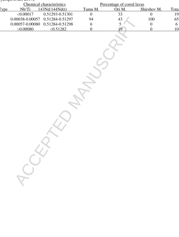
Sano et al. (2012) and Husen et al. (2013) reported chemical compositions of a total of 170 fresh glass samples from four of the Expedition 324 drilling sites (U1346, U1347, U1348, and U1350). Such fresh glass samples are preferred for geochemical studies owing to their lack of alteration. No fresh glass was recovered from Site U1349, so whole rock analyses were done on the freshest basalt samples (loss on ignition, LOI, <3.2 wt %). In plots of elements and oxides versus MgO content, the data from glass and fresh rocks show that Shatsky Rise igneous rocks are abyssal tholeiitic basalts whose compositions are similar to MORB and OJP basalts (Fig. 13). Chemical compositions and Nb/Ti ratios (both alteration resistant elements;
Table 1) allow the division of Shatsky Rise basalts into four types: (1) normal, (2) low-Ti, (3) high-Nb, and (4) U1349 types (Sano et al., 2012).
ACCEPTED MANUSCRIPT
Chemical compositions of the normal type basalts are similar to normal-MORB (N- MORB), with trends that can be explained by fractional crystallization under low-pressure conditions (Fig. 13). These rocks vary from less evolved (MgO ~8.5 wt %) to more evolved (MgO ~5.0 wt %). Most basalt samples from Sites 1213, U1346, U1347 and U1350 are classified as the normal type, the dominant basalt in Shatsky Rise, with 94% of Tamu Massif, 43% of Ori Massif, and 100% of Shirshov Massif rocks being of this class (Table 1).
Low-Ti type rocks are present at Site U1347 on Tamu Massif and Site U1350 on Ori Massif. The total percentage of low-Ti type among cored lavas is estimated to be 6%, the smallest among the four types (Table 1). This rock type has slightly lower TiO2, FeO*, MnO, V, and Sr, and higher Al2O3 contents compared to the normal type basalt. In addition, this class includes only rocks with evolved compositions (MgO <7.0 wt %). Comparison of low-Ti rocks from Site U1347 versus Site U1350 shows that the former are more highly evolved (MgO <5.5 wt %) than those of the latter (MgO >6.0 wt %). This fact suggests that the lavas from these two sites have different magma sources, an interpretation supported by Nd and Hf isotopic data from one of the samples from Site U1350, which has a slightly enriched isotopic composition (slightly lower 143Nd/144Nd and 176Hf/177Hf) compared to those from Site 1347 (Heydolph et al., 2014).
The high-Nb type is characterized by distinctly high contents in K, Nb, Ta, Zr and rare earth elements (REEs). Trace-element signatures for these rocks are similar to enriched-MORB (E-MORB) (Fig. 13) from the East Pacific Rise. The enriched characteristics are also confirmed by isotopic data; higher 207Pb/204Pb and lower 143Nd/144Nd and 176Hf/177Hf (Heydolph et al., 2014), suggesting the presence of an enriched mantle source. Simple fractional crystallization processes cannot explain the differences between the normal-type and
ACCEPTED MANUSCRIPT
the high-Nb type, implying different mantle source characteristics. The high-Nb type only appears at Site U1350 on Ori Massif, but is identified in several lava flows from this site. The percentage of high-Nb type rocks among the total cored lavas is estimated to be 10% (Table 1).
Similar trace-element enriched rocks were recovered from one interval of the ~120 m-thick volcaniclastic section at Site U1348; however, compositions of the Site U1348 rocks are different from the high-Nb type basalts of Site U1350 and because only volcaniclastics were cored at this site, the Site U1348 samples have not been factored into the estimated percentage of magma types (Sano et al., 2012). In addition, similar isotopically-enriched lavas have been identified in dredged seamount samples from the northern sector of Shatsky Rise (Tejada et al., in press).
Despite the effect of alteration on Site U1349 samples, which affected these rocks more than at other sites, the rocks from this site appear to represent significantly less evolved magmas (MgO, 9-12 wt %) than those of other magma types (Fig. 13). Moreover, the Site U1349 lavas are highly depleted in incompatible trace elements compared to the normal type lavas, a difference indicating that the former cannot be parental for the latter. Less evolved compositions are consistent with analyses of melt inclusions contained in fresh olivine phenocrysts from Site U1349 (Almeev et al., 2011). These melt inclusions have less evolved compositions with high MgO (>11 wt %) and are very similar to those of the whole rocks (Almeev et al., 2011; Sano et al., 2012). Since melt inclusions in fresh olivine give information about the magma before alteration, the U1349 lavas can be confirmed as being derived from a fourth magma type (i.e., type U1349). The 85-m-thick basement section at Site U1349, on the summit of Ori Massif, is composed of only the U1349 type basalt. The percentage of this type is estimated to be 19% of the total recovered lavas from Shatsky Rise (Table 1). Compositions