Ordnungen im Wandel
Sonderforschungsbereich 640
Melanie Krebs und Madlen Pilz
Anthropological Urban Transect
A Methodology to Study Urban Environment
Schrienreihe des Sonderforschungsbereiches 640: „Repräsentationen sozialer Ordnungen im Wandel“ in Zusammenarbeit mit dem Dokumenten- und Publikationsserver (edoc) der Humboldt-Universität zu Berlin.
ISSN: 2190-314X
Redaktion: Mahias Braun, Vincent Houben, Stefan Kirmse, Anika Kre, Sascha Stingl, Reet Tamme
V.i.S.d.P.: Vincent Houben
Melanie Krebs und Madlen Pilz
Anthropological Urban Transect: A Methodology to Study Urban Environment
Zitationsempfehlung:
Melanie Krebs und Madlen Pilz, Anthropological Urban Transect: A Methodology to Study Ur- ban Environment, in: Working Papers des Sonderforschungsbereiches 640 1/2013, hp://edoc.hu- berlin.de/series/sfb-640-papers/2013-1/PDF/1.pdf
Humboldt-Universität zu Berlin Sonderforschungsbereich 640 Mohrenstraße 40-41
D-10117 Berlin
Web: www.sfb-repraesentationen.de Wissenschaliche Koordination:
Mahias Braun Fon: 030.2093.4864
Mail: mahias.braun@staff.hu-berlin.de
Die Meinungen, die in den Working Papers des Sonderforschungsbereiches 640 geäußert werden, geben aus- schließlich die Auffassungen der Autoren wieder. Abdruck und sonstige publizistische Nutzung, die über die in Forschung und Lehre üblichen Zitate hinausgehen, sind nur mit vorheriger Zustimmung der Redaktion sowie mit
Abstract
Anthropological Urban Transect: A Methodology to Study Urban Environment
is paper presents the application of a methodological approa originally developed for ur- ban planning to urban anthropology. is resear approa focuses on different materialities in order to analyze functional zones, special areas and several categories of markers of up- and downgrading processes within a city. is focus on materialities and their integration paerns into urban space enables to make systematic comparisons between different areas within a ci- ty as well as between different cities. Using examples of transects carried out in two Southern Caucasian capitals – Baku (Azerbaijan) and Tbilisi (Georgia) – different ways of implementing a transect, collecting and recording the data are discussed.
Authors
Melanie Krebs studied Islamic Studies (with special emphasis on Turkey and Central Asia), His- torical Anthropology and Classical Areology in Freiburg/Breisgau and Istanbul. She received her PhD 2009 in Central Asian Studies at Humboldt University and is currently a postdoctoral resear fellow at the Collaborative Resear Center “Changing Representations of Social Order”
within the sub-project “Identity Politics in the South Caucasus”.
Madlen Pilz studied European Ethnology at Humboldt University and History, Areology and Anthropology of Latin America at Free University/Berlin and Catholic University in Ecuador.
Since 2008 she is a resear fellow at the Collaborative Resear Center “Changing Representati- ons of Social Order” within the sub-project “Identity Politics in the South Caucasus” and conducts field work in Tbilisi (Georgia).
to Study Urban Environment
Introduction
e anthropological project “Identity Politics in the South Caucasus: National Representation, Post-socialist Society and Urban Public Space” conducted resear in the South Caucasian capitals Baku, Tbilisi and Yerevan between 2008 and 2013. e project focused on gathering and comparing the post-socialist anges in the symbolic, material and social urban landscapes of the region.
Furthermore, it explored the question of how to define the dynamics and elements of these anges and how to analyze the local, regional and global influences – for example, how the national and the socialist pasts, and the democratic-liberalist and neoliberal strategies shape urban spaces and new societies.
In order to explore everyday life and the shape of a city, urban anthropologists use different me- thodological tools including participant observation and so-calledWahrnehmungsspaziergänge, go-alongs or urbanographies as instruments of an “anthropology in the city”. Interviews, talks and different ways of mappings are common to collect the perceptions and uses of urban places and areas for analyzing individual and collective views of the city. But the question of how to capture systematically the material, symbolic and social order of the cities as a whole still re- mains a problem. erefore the application of the transect, a methodology originally used in the natural sciences, specified and implemented for urban planning, seems to be a promising tool for urban anthropology. e aim of this method is to gather the different layers systematically and to connect the perspectives of an “anthropology of the city” and “in the city” as well as to design a tool to compare the findings on different cities.
In this paper we propose a way to apply the transect in anthropological urban studies. We describe ways to carry out a transect based on our experiences in the South Caucasian capitals. We discuss different features of the transect and present categories implemented into the transect as tools for researing urban anges.
From Biology to Urban Studies
Transects are traditional forms of regional surveys in, for example, biology and geography.¹In re- cent years, they have also been applied in developmental community studies²and urban planning.
As a resear instrument, transects are generally used for identifying the quantity and quality of the distribution of certain populations or materials in a specific area. In practice, it suggests follo- wing a randomly osen sideway path through a defined area to count the territorial occurrence of certain species. e results indicate the spatial distribution of these species and of their land use practices. In this manner, transects show general paerns of everyday uses of space.
In the 1990s, a group of city planners and aritects – the New Urban Planners³around Andrés Duany and Elizabeth Plater-Zyberg who proposed the idea of a New Urbanism in cities in the United States – adopted the transect as a tool to improve urban planning. ey started to use this method in order to visualize the ideal structure of a city and the distribution of infrastructure required by its residents. eir model transects were developed to help urban planners avoid urban sprawl and develop cities in whi ea district offers equal facilities for shopping, health care, education, leisure and neighborhood activities.⁴e New Urbanists identified six different zones from the rural to the city core zone (illustration 1) in the common US-city, whi are distinguished by functional features. ey defined a list of formal markers for ea zone including density, functional mix, the design of buildings and places in public and in private ownership. Furthermore, they focused on the specific, small-scale elements of the material and design that are aracteristic for ea zone.
According to Plater-Zyberg’s and Duany’s findings, rural and suburban zones are aracterized by a lower building density than central and core urban zones. In these inner city zones, free space – that is, areas not used for construction – is becoming more and more limited and rents for living and businesses are increasing. Ea urban zone has its own typical street furniture and respective paerns of distribution – for example, lampposts with a more sophisticated design and made of beer materials are more frequently distributed in the city center than in the suburbs and rural zones. In an exemplary study in Williamsburg, Virginia, Bohl and Plater-Zyberg demons- trated how it is possible to aracterize different urban zones by different types of fences: from rough wooden structures, whi are not designed to impress but to keep strangers away in the rural zone, and neatly painted fences in the suburban zones, whi also represent the landlord’s care of his property, to the ostentatious fences in the city center, whi symbolize both borders and the importance of the space behind.⁵
1 Compare: D. Matless, “Regional Surveys and Local Knowledges”, in:Transactions of British Geographers, 17 (1992), pp. 464–480, in particular p. 469.
2 Community researers used this methodology especially to find out more about water and soil use and sanitary conditions in a community. ey extended the concept by encouraging locals to accompany the researer through the transect and share their knowledge.
3 We also use the shorter terms New Urbanists or the abbreviation NUP to refer to the New Urban Planners.
4 Andres Duany/Emily Talen, “Transect Planning” in:Journal of the American Planning Association68, 3, (2002) pp. 245–166.
5 Charles Bohl/Elisabeth Plater-Zyberg, “Building Community across the Rural-to-Urban Transect in:Places18(1) (2006), pp. 4–17.
Illustration1: Physical Characteristics of the Transect, hp://www.transect.org/rural_img.html
In sum, the transect developed by the New Urbanists is a tool that captures structural, everyday, and social aspects of the different urban zones. ese vary from zone to zone while internal va- riations within ea zone are oen neglected. As a result of their concentration on zone-specific materialities, zones are generally described as homogeneous parts of the city.
e art historian Dino Marcantino has criticized this point and the New Urbanists’ limited con- sideration of horizontal materialities.⁶For this reason, he developed the “Iconographic Transect”⁷, puing aritecture and façades, in particular, in the center of analysis. In so doing, he tried to create a tool for identifying and describing the internal structures of different zones. His idea is based on the assumption that in ea zone buildings range from being “rustic”, and “vernacular”,
“low classical” and “high classical” to “monumental”. A “monumental” structure marks important buildings in ea zone – like a small mausoleum or sanctuary in the rural zone, the town hall or main cathedral in the city center. e appearance of street furniture, for example, and the orna- ments that can make a building “vernacular” or “monumental”, are restricted to particular zones.
As he points out, ornaments that mark a building as “monumental” differ in ea zone. Ornaments that are transferred, for example, from the core to the suburban zone are perceived as something that does not “fit in” or as “kits”.⁸
e urban planner Jaime Correa criticizes another point. He accentuates that urban transects focus too mu on a “model city” or a typical middle-sized US city planned right from its foundation.
For that reason, he criticizes the approa as not suitable for complex cities shaped by history, culture, climate, and topography. Correa argues that most cities are far too complex to be reduced to the strict paern of an urban-to rural-transect.⁹He emphasizes the ethnocentric aracter of the transect, whi makes it complicated to apply it to, for example, traditional Muslim or European medieval cities.
For anthropological purposes, both critiques enri the data whi can be gathered by a transect since in anthropology, the question of a city’s design and development is always seen as culturally, historically, economically and politically path-dependent. For resear purposes, the zoning model and the New Urbanists’ descriptive features are not seen as a normative matrix, but as culturally and geographically-based expressions of a variety of elements that produce urban environment and construct urban space. e anthropological value of the tenical, construction and design elements identified by the New Urbanists is threefold:
1. Seeing the transect as a way to gather and arrange data offers a good matrix for interregional and intercultural comparisons.
2. Seeing the transect data as visual and material evidence offers insights into wider political and economic influences.
3. e focus of the transect on small-scale elements enables the researer to preserve types of collective and individual, formal and informal appropriations.
6 In their typical transects, the New Urbanists reduced buildings to their ground views, that is, to occupied space and functional features.
7 Dino Marcantonio, “Iconography and the Transect”, hp://www.planetizen.com/node/89 2003.
8 Marcantino “Iconography” and Bohl “Building Community”, pp. 6, also made this observation in their study on fences.
9 Jaime Correa, “Counterpoint: Transect Transgressions”, inPlaces18(1) (2006), pp. 24–25.
Transferring Transects to Urban Anthropology
e idea of walking through a city while concentrating on small material details and the ap- pearance and behavior of its residents has different forerunners. In the literary world of the 20ʰ century, it is connected with the figure of the flaneur in the European capitals of Paris and Ber- lin and especially with the name of Walter Benjamin. e flaneur is both an urban native and a detaed observer who is able to recognize the slightest ange.¹⁰
Transects introduce a special tenique into investigative walks as a type of urban resear, dis- tinct from go-alongs¹¹and other forms su as narrative urbanism, or city telling¹²and Big Urban Walks¹³. In Margarethe Kusenba’s go-alongs and Elke Kransny’s city telling, locals lead the researer through their everyday lives sharing their explanations, memories and spontaneous thoughts about urban space. Kusenba distinguishes between the “natural go-along”, where the researer accompanies the informant on her or his everyday routes, and the “contrived” or “ex- perimental go-alongs”, whi implies walking and talking with the informant outside his familiar areas.¹⁴With regard to the way in whi the route is determined, a transect is comparable to the experimental go-along. But in contrast to a “go-along” or “city telling”, the focus of a transect is not primarily on local perceptions and constructions of urban space. e central point is to obser- ve the structure and everyday life of the city and to compare the different urban layers within the city. In other words, it is a way to classify typical and non-typical interrelations between the ge- neral structure of a city and certain places. It makes it possible to recognize the interplay between different levels like 1ˢ the global, the local, and the regional, 2ⁿ the past and the contemporary 3ʳ
the collective and the individual. e main objective is to find out how these social interactions are inscribed on the material surface of the different parts of the city. Individual local perceptions and interpretations can also be included. In this manner, a transect creates the prerequisites for comparative work within and between different cities, paying particular aention to the range of forms of material culture that shape the city.
Transect – Baku and Tbilisi
In both cities, we decided to use a transect that covered both prestigious and non-prestigious parts of the city, that is sites of everyday life and sites that are excluded from it. In this manner, it was possible to get to know the aracteristic anges in the structure and texture of the cities.
Azerbaijan gained its independence from the Soviet Union in 1991. Its new wealth
10 Rob Shields, Fancy Footwork. Walter Benjamin’s notes onflânerie. In: Keith Tester (ed.)e flâneur. (London/New York: Routledge 1994) pp. 61–80.
11 Margarethe Kusenba, “Street Phenomenology: e Go-Along as Ethnographic Resear Tool”, inEthnography (2003) 4(3) pp. 455–485.
12 Elke Krasny, “Narrativer Urbanismus oder die Kunst des City-Telling” in:Urbanographiesed. by Elke Krasny, Irene Nierhaus. (Berlin: Reimer 2008), pp. 29–44.
13 Martin Kohler, hp://www.pps.org/blog/between-walking-and-wandering-power-in-presence/, last access 22.11.2013. Big Urban walks follow the same plan as transects, but the data recording is exclusively visual.
14 Kusenba “Go-alongs” pp. 463–464.
is based on the oil and gas mining industries around the capital city of Baku. Baku is geographically shaped by the long coastline along the Caspian Sea and the sur- rounding hills, whi gave the city the shape of an amphitheater – or at least gave it, before the skyscraper in the center started to be higher than the hills in the last few years.
In 1806, when the Russian Army seized Baku, the city was a small port on the Caspian Sea. e walled old town dates ba to this period. at oil, found around Baku since medieval times, became the world’s most important resource in the late 19th century accounts for the biggest transformation of the city. Around 1900 Baku was one of the riest cities in the world, a splendor that manifests itself in Art Nouveau buildings around (and also within) the old town, and in the industrial outskirts near the harbor, the so-called “Bla City”. As the capital of the Azerbaijani SSR between 1936 and 1991 and a major industrial and port city, Baku grew during Soviet times and the typical apartment blos of this period can be found in the city center and in the microrayons surrounding the city. Most of the Soviet monuments have been destroyed and replaced with grand parks or new national memorials.
e second oil boom started in the late 1990s and led to a new construction boom, with post-modern glass-and-concrete skyscrapers rapidly anging the city. While a small number of the Art Nouveau buildings around the central Fountain Square were carefully renovated, most quarters of the city that date ba to the first oil boom were destroyed to make room for parks and skyscrapers.
Since 1991, Tbilisi has been the capital of independent Georgia. Since then it has seen a succession of governments, whi were all overturned by revolutions, different civil wars in the 1990s in Tbilisi, Abkhazia, and South Ossetia, and a military intervention by Russia in 2008.
In 1801, Tbilisi became the capital of the Russian province Georgia and the head- quarters of the Russian governor in the South Caucasus in 1822. is meant big
anges for the city on both a symbolic and a material level. Tbilisi acquired the status of a dependent and peripheral capital. A Russian or European district, in whi monumental and almost classical styles dominated (though Art Nouveau and, to a degree, Orientalized classicism also appeared), was added to the so-called multiethnic and multireligious medieval town. Institutions perceived as part of a European high culture were opened, and industrialization developed following European paerns. e oriental-like market square became the cultural center of the Caucasus. Aer a short period of independence (1917–1921), Tbilisi first became the capital of the Transcaucasian Soviet Republic and later of the Georgian Socialist Soviet Republic (1921–1991). e city experienced a second wave of anges, whi
can be interpreted as modernization or as the partial demolition of the old building fabric since the anges (according to the socialist idea) aimed to bring more open space, air and light into the city. Once again the city was enlarged in order to accommodate all the rural migrants who came to work in the growing number of
companies owned by the socialist state: from the 1930s, buildings were added in the typical Stalin Empire Style and from the 1950s, in the shape of prefabricated high-rise apartment blos. Since the Rose Revolution in 2003, the city has experienced a new phase of modernization. Monumental, postmodern glass buildings represent the current anges.
e transect through Baku followed one of the most important streets, the Nizami Kücesi. e Nizami Street is nearly 3 km long and leads from the city center to the industrial outskirts near the harbor, always parallel to the Caspian Sea. e oldest buildings along the street date ba
to the second half of the 19ʰ century and are located in the city center, next to the recently- built skyscrapers. On the way to the industrial zones, the researer walks past Soviet residential buildings, both converted and operating factories and, eventually, the railway line. So it is an example of a transect that covers different Bakuvian urban zones, prestigious central parts, zones of everyday life and intermediary and peripheral areas– at least at the time when the transect was carried out in 2010/2011. In a quily anging city like Baku, transects are necessarily but a snapshot of the time when they were done. e transect concentrated on commonly ignored elements of material culture along the street, su as street signs, house numbers, and memorial plates.
Street signs, for example, ange from zone to zone: while the street signs in the city core zone and center are made from the same sandstone as the 19th-century houses and thus give the impression that they date ba to the first oil boom, they were put there in 2010. For someone with knowledge of this period the fake is easy to spot: e signs use Latin leers, not the Arabic or Cyrillic alphabet whi was used around 1900. In the suburban zone, the signs also display the now official Latin leers but are made of eap metal. Some signs have survived from Soviet times when street names were wrien in both alphabets: Cyrillic and Latin. e number of these signs increases in the next zone where factories dominate near the railway line. e number of street signs in general is quite small in this zone, and the ones that are still there are rusty and hardly readable. Foreigners hardly ever come to this part of the city and there is no need for information or show-off here.
In Tbilisi, the transect was carried out from the center to the southern periphery alongside the river. Because of Tbilisi’s linear structure, the city is very narrow in some parts. us it was difficult from time to time to follow a straight line on sidewalks, and for that reason, main roads were also included. e transect focused on national, socialist and global influences on the urban materiality; on the merging between public and private, and on individual and public use of urban space, especially economic use.
In both Tbilisi and Baku, it is possible to find the different functional zones identified by the New Urbanists. It is particularly striking that the succession of the zones anges partly in accordance with geographical features. Tbilisi, for example, is situated between mountains.
Tbilisi(partial outline of the transect) New Suburban area
Situated on the Mtatsminda plateau, a mountain providing the territory of Tbilisi with natural borders
Typical features: one-family coages, gated zones. Recreational area: green hills.
Landmarks: amusement park (renovated socialist amusement park), Pantheon of Writers and Public Figures.
U rban Core Zone
Typical features: historic center – ures and historical residential buildings. Re- sidential area, representative buildings – parliament, ministries, embassies; public buildings, institutions of high culture, bars and restaurants, sools, libraries, tourist area. Informal zoning: “Leselidze” Leselidze Street is a residential and shopping area in the old town that represents the city’s medieval past; “Bambis rigi” Bambis lane is an amusement and tourist area; “Kolkhos Square/market” large, former market for agrarian products and still used as a market square. Problem: major reconstruction activities, demolition of old buildings and new constructions followed by gentrifi- cation: arrival of international organizations and heavy population exange and maximum deterioration of old buildings.
Central Area Zone
“Avlabari” is a neighborhood that since 2004 has experienced drastic ange. Former features: a residential zone with no prestigious and nearly no public buildings, old one-family homes in bad condition, still based on the village structure it had when it was incorporated into Tbilisi at the beginning of the 20ʰ century. Former landmarks:
e Armenian Pantheon, Park of Friendship. New features: new aritectural mo- numents – national cathedral, presidential palace, new urban park Rike, refurbished old houses, newly built coages, new tourist and religious infrastructure – hotels, restaurants, souvenir shops. Informal zoning: Market, situated near the traffic junc- tion “Metro” and the road to the airport.
Residential Area
Typical features: socialist part of the city, territory outside the city maps for tourists, prefab blos, closed-down factories, public buildings – sools, libraries, a hospital, Georgian orthodox and Jewish cemeteries, some offices, administration, some new but mostly empty blos. Informal zoning: “Isani” – according to some, the ea- pest market in Tbilisi, the Azerbaijanian market, in a closed-down mill and around it, near the metro station Isani. Outside the metro system: garages – small informal garages offering all kinds of car services for a small budget, along the railway line;
djarti area – scrap trade on unused land previously occupied by demolished factories or other Soviet constructions. e area is located on the periphery of the residential area. Hidden features: internally displaced people (IDPs) currently live in some of the old factories.
Urban Edge
Residential area: some new production sites, new ures, a lot of green and empty space.
For anthropological ends, however, the symbolic texture of the city is equally important. For this reason, we also distinguished between the symbolic sub-zones made by inhabitants.
In Baku, the zones that can be distinguished according to the model are more or less congruent with local designations for different parts of the city. So the suburban zone along the railway line, whi is aracterized by small buildings and a few Soviet apartment blos, is called “near the bread factory”, a reference to the last factory in this zone that used to be an industrial area until the early 1990s. But names can also draw on new and conspicuous markers that are untypical for a zone: e residential zone shaped by late-Stalinist apartment blos with their typical bayards is known as “around landmark” – one of the first skyscrapers built during the Second Oil Boom.
As a toponym, it refers to this residential zone, not to the neighboring city center or suburban area.
is kind of collective informal zoning and naming reflects different practices in the perception of urban space. First, it mirrors everyday uses of the city, and second, a symbolic perception that differentiates between a national or a socialist style and new aritectures. Up to 2012, the different cities displayed aracteristic features. at the city administration installed new street
“furniture” exclusively in the urban core was part of urban redevelopment. As in Central Asian cities, public space is still an object of centralized/state design strategies limited to a few important streets and squares.¹⁵
Density is considered to be an aribute of urbanization, and New Urbanists see it as a marker that helps to distinguish zones. For them, the urban core zone displays the highest building density and the smallest amount of green and open spaces between buildings. is might be true for the medium-sized, largely unindustrialized cities they worked in, but in many European and North American cities, the urban core zone is aracterized by open space, wide avenues and extensive parks surrounded by areas of high building density. In the late 18ʰ and the 19ʰ centuries, wide central avenues and squares were used for showing military strength, national pride or everyday proximity between the people and those in power, a tradition whi was carried on in the socialist countries through the 20ʰ century.
Since the 19ʰ century, parks have also been used in industrial cities as a part of a strategy to create health and recreational space for the “working mass”. In the capitalist countries of North America and Western Europe, the construction of parks also led to an increase in the value of building ground around it, while land in general was not assessed in monetary terms in the Soviet Union.¹⁶ Defining “urbaness” in su a way that a higher density of buildings means a higher degree of urbanization ignores the fact that the luxury of “wasting” valuable land in the middle of a city by
15 See Victor Buli “Areology of Socialism” pp. 40–69. is phenomenon is contrary to developments in cities like New York, where the redevelopment of public space is driven by public/private partnerships or even by private investors (Sharon Zukin,Culture of Cities(Cambridge/Mass.: Blawell 2008).
16 Riard E. Fogelsong:Planning the Capitalist City.(Princeton: University Press, 1986). pp. 89–102.
creating extensive greens, wide avenues or squares is perceived as an important part of creating and representing an urban core in a big city. erefore the highest density is usually found in the zone surrounding the urban core zone.
In Baku, the Fountain Square – a paved square with green zones, playgrounds and fountains – is the most important landmark in the urban core. It was originally con- structed in the 19ʰ century colonial city as a parade-ground for the Russian army, but became a space for leisure and a see-and-be-seen promenade during Soviet times.
e square was renovated in 2009/2010. Fountain Square and the neighboring streets are considered to be the heart of the city with many expensive shops and Western- style coffee shops, whi are almost empty compared with the open space that is usually overcrowded with people of all ages in the late aernoons and evenings.
Even though Fountain Square is heavily observed by cameras, police and security guards, the space is usually perceived as “free” especially by young people, who use it to gather with friends outside the social control exercised within their own neigh- borhoods. In 2012 there were still some political demonstrations in Fountain Square whereas the demonstrations that took place a year later mostly concentrated on the outskirts of Baku.
Features of the Symbolic Urban Texture – Special Districts and Blind Spots
According to the New Urban Planners, special districts are parts of the city that do not fit in the zoning model. ey can appear in any zone and are loosely or not connected to their surroun- ding zone. In the planning transect, college campuses, industrial districts, and traffic hubs su
as airports and railway stations form typical examples of these special districts. Meanwhile, sites su as the college campus or industrial districts might be typical American examples of special districts; in the context of post-Soviet cities, these sites must be categorized differently. In post- Soviet cities, industrial regions are traditionally incorporated into residential areas in peripheral residential and suburban zones.e whole list of examples established by the NUP for the catego- ry of special districts seems too wide for anthropological resear where the focus is on physical and symbolic appropriations (that is, the ways in whi these sites form part of the routes of ever- yday life and how they are appropriated by memories or narrations of the city). On the basis of these considerations, it is difficult to identify special districts in Baku or Tbilisi as defined by the NUP. But if we take the idea into account more metaphorically and start to look for fault lines that distinguish the condition, atmosphere, and materials used in certain sites in one zone, we will recognize certain urban structural paerns that provide deeper insights into the appropriations of space.
Following this logic, we can identify “special areas” or “specialized areas” in Tbilisi that can be classified by their function, their use of place, special form. e afore- mentioned open-air markets (bazaars), ferrous scrap trade and workshops (for cars) can be seen as part of this category. Typically they are located in disused socialist
constructions, for example factories, that are situated in the typically socialist re- sidential areas. While based in former state-owned economic institutions, they are now organized and planned by individual initiative. On a material level, these priva- te small-scale economic activities are not fully stabilized, the constructions are just reused and reconstructions are improvised. e activities meet the everyday needs of the population and seem to be aimed at small budgets, whi is reflected in the prices and origins of the services and products offered – self-made, Georgian, Tur- kish, Azerbaijani, or unknown. ese points accentuate a break between these sites and their surroundings, but on other levels the connections become evident. First, the low-budget economic initiative connects them with the inhabitants of their neigh- borhood and with people from the wider city area. Second, as they meet popular needs, they are part of everyday routes through the city; and third, these sites form informal urban markers in conversation and within the system of urban orientati- on. On a functional level, they seem to form “specialized areas” in the city; on the material and symbolical levels, they are manifestations of people’s economic needs.
e Tbilisian examples demonstrate the existence of “specialized areas” that are used by a specific part of the population on a regular or daily basis, and therefore these areas are connected with other parts of the city by complex paerns of mobility. We discovered another variety of special districts in Tbilisi and Baku with features that are almost the opposite of those identified above:
sacred places, and national memorials. ey oen seem to be noticed only on special occasions when they aract people from a mu wider geographical area than the actual zone.
e national memorial in Baku, the Martyr’s Alley, was built as a graveyard for the Bakuvians killed by the Soviet army during the violent repression of the Azerbaijani uprising in January 1990. Gradually it was converted into a national memorial that now also includes a WWII memorial and a graveyard for soldiers killed during the Karabakh War 1992–1994. Located on a hill overlooking the bay, the structure with the eternal flame is widely visible from the city center, but it is not within typical mobility paerns. As a result, people do not just pass by. e Martyr’s Alley moves into the center of national aention only once a year on 20 January, Memorial Day.
On this day people from all over the country come here to commemorate those killed by the Soviet army, an event that is widely covered by the media. ere is no special memorial day for the soldiers who died during the Karabakh War and who are also buried there. For mu of the rest of the year, the memorial is widely neglected. Even if some people still come to visit the graves of their relatives, most visitors come to enjoy the seaside view and the fresh air.
For anthropological purposes, it seems reasonable to distinguish between different kinds of spaces that produce a rupture in the structure of the surroundings and are therefore not recognized as part of this zone by locals. Meanwhile, special districts form part of everyday life to varying de- grees; other places, in contrast, can be aracterized as “forgoen places” or “blind spots”.¹⁷ey
17 For example Kusenba and Krasny. Blind spots can also be compared to the idea of spatial asyndetons how they are described by de Certeau (following J.-F. Augoyard). Asyndeton is an aspect of individual movement and
are usually not mentioned in conversations and interviews, they do not function as landmarks, they are not connected by everyday activities, and they are (no longer) part of personal memories.
Typical examples of “blind spots” that exist in every zone are abandoned buildings, construction sites, and sometimes unused parks or playgrounds that are not even considered to be dangerous, otherwise they would be mentioned. In Baku and Tbilisi, we noticed the existence of a very parti- cular kind of “blind spots” in urban core zones, whi are connected to certain historical periods, problems and events that are suppressed in the collective memory.
In the center of Baku, the old Armenian Cathedral is a striking example of a “blind spot” in the collective memory of Bakuvians about their town. e Cathedral was closed aer the pogroms against the Armenian population in Baku in 1990. While the building itself is hard to miss, the ur is not usually mentioned in interviews or when people give directions. Typical orientation points are “Let’s meet at the ice- cream vendor with the red umbrella” or “In front of the new fancy coffee shop” – both answers gently exclude the huge Armenian ur on the corner. For some Azerbaijanis, the reason might be to avoid any memory of the former Armenian Cathedral in Baku’s center. But since neither Armenian nor Russian Bakuvians use the building as a reference point, the former center of Armenian religious and cultural life in Baku is no longer a site of everyday identity construction – in contrary to the ice-cream vendor or the coffee shop.
In Tbilisi, the Azerbaijani cemetery, whi is situated on the periphery of the old city, offers a similar example. Today the cemetery is in the bamost part of the botanical garden, and there are no signs leading towards it. Large areas of it are used for floriculture and are not recognizable as a site of graves anymore. Only old Tbilisians who spent their ildhood in the old part of the city know of its existence and reuse.
Markers of Urban Change – “Canary Birds” and “Lighthouses”
e notion of ange is central for investigating urban environments. Two directions − up- and downgrading – are aracteristic dynamics of urban ange under both neoliberal and post- Soviet conditions. For a transect, it is therefore advisable to introduce elements that can make these processes visible on the material and the symbolical levels. e term “lighthouse project”
seems suitable to describe projects that are models for further development, in addition to their functional purpose. In the urban context, “lighthouses” are building projects that can be seen as casting a light on previously neglected neighborhoods. ey are placed in the neighborhood by outside actors (state, economic or religious organizations) in order to initiate the desired anges.
In Baku, the covering of Soviet facades with (fake or real) sandstone panels (finan- ced by the state) makes them look more like First Oil Boom mansions. is aempt to create a clearly defined aesthetic ange with lile effort can be interpreted as a
perception of space that includes the skipping of whole areas, sites from the individual city map. Miel de Certeau
“Kunst des Handelns” (Berlin: Merve 1988) p. 195.
“lighthouse”-project, aimed at enhancing the status of the neighborhood and remo- ving the aesthetics of the socialist past.
In Tbilisi, the government painted selected façades of peripheral Soviet apartment blo buildings in screaming colors and thus created “lighthouses” symbolizing go- vernmental care in the urban and social periphery.
In contrast to the “lighthouses”, “canary birds” are signs and agents of social and economic an- ge driven by the anging needs of residents.¹⁸ey symbolize anges in the urban structure that refer to anges on the meso- and macro-level of the city and society.¹⁹e appearance and disappearance of shops and facilities in certain neighborhoods reflects the dynamics of social downgrading or upgrading in the city, including a shi in social and cultural values, and a an- ge in collective desires. e emergence of being agencies, pawn houses and ”99 cents” shops, for example, can be seen as the “canary birds” of economic decline of a neighborhood. In con- trast, fancy coffee shops, tearooms, galleries and shops offering organic goods are the signs of continuing gentrification.
In Baku, shops providing eap internet access vanished from the city center over the last few years. is development corresponds with an increase in Western-style coffee bars offering wireless internet, Western-style snas, and a more comfortable atmosphere. An increasing number of young people who can afford laptops and ex- pensive coffee creations flo to these bars.
e construction of the Cathedral of the Holy Trinity (Sameba) in the 90ies was a lighthouse project announcing the new strength and official acceptance of the Or- thodox Chur. Since then, lile ures in medieval style have appeared also in socialist residential areas. Most of these religious building projects have been initia- ted and financed by the neighborhood. So here the apels appear to be canary birds of the wider recognition of the ur as an important institution in everyday life, and the public recognition of individual initiative as a form of participation in urban
ange.
e New Urbanists designate some signs of ongoing but just occasionally visible ange as “out of zone” or “kits”. “Out of place” elements are aracterized by a new or a different aesthetic; they are indicators of new desires that oen articulate new cultural trends or social differentiations in the area of resear. In contrast to lighthouse projects but in comparison to canary birds, “out of place” elements are aracterized exclusively by individual activity and may serve as indicators of a do-it-yourself-urbanism.
In Baku, restaurants in “typical Azerbaijani style” oen display elements resembling rural compounds with wooden fences, artificial trees and stuffed animals or life-size puppets in more or less authentic traditional costumes at the front. Even if indivi- dual elements have a connection to Azerbaijan, the overall impression is one of a
18 e term is inspired by the canary birds that miners took with them into the mine because the behavior of these highly sensitive birds signalized whether the concentration of invisible gas became dangerous.
19 Tijs van den Boomen, Die unsitbare Mauer, in:Spiegel Online, 2011–08–21,
hp://www.tijsvandenboomen.nl/?page_id=2&mode=browse&artikel_id=1398 (last access 28/11/2013)
Russian or Western fairy tale. But that does not mean that their clients are mainly foreigners – on the contrary, there are many Azerbaijanis who enjoy an atmosphere connected with a diffuse longing for a “golden age” when everything was beer than today.
Fenced-in areas in the house yards used as garages or gardens to raise greens and vegetables are still aracteristic of the socialist quarters of Tbilisi. ese gardens and garages date ba to the Shevardnadze era when food supply was a serious pro- blem for many people and criminal activity was high. Ba then, this kind of private gardening was essential for many whereas today these gardens are an illicit relict or already private property.
Conclusion
is paper adopted the transect method from urban planning and used it for anthropological resear. e application draws on a variety of aspects the New Urbanists identified for urban development. ese aspects cover functional features on the level of materiality, furnishing, at- mosphere and facility supply that urban neighborhoods should offer.
e anthropological transect uses this catalogue of aspects for qualitative analysis to describe specific aracteristics of cities. Going beyond the aims of the New Urbanists, the anthropolo- gical use of the transect method introduces the symbolic level of the urban materials into the resear. It does so by focusing on distinct uses that offer insights into the emic system of values and meanings. To grasp the constant economical, political and cultural anges that aracterize the field of the everyday and the urban landscape in Baku and Tbilisi, we introduced additional elements – the markers of the anges – into the transect. In this manner, different categories of urban signifiers emerge that seem to visualize anges and their specific dynamics.
In anthropology the transect is a systematic form of Wahrnehmungsspaziergang (urban walk) along a predefined route. It puts the open and actor-centered approaes of go-alongs and city telling into the framework of urban materiality and the use of urban space. is systematic and strictly space-bound collection of data (1) reflects the quantity of the appearance, (2) shows pat- terns of the spatial distribution and (3) includes the seing of these objects on the material and symbolical levels. e data therefore allow multiple comparisons between different areas within a city and between cities.
e urban transect is an instrument for the start of fieldwork; a first exploration of the diverse urban conditions in a cross-section from the center to the outskirts. e predetermination of the transect route alongside detours, as it is common in other academic fields, also seems reasonable to use in and adapt to anthropology. is mode highlights randomness as the main approa
for the first entry into the field and allenges to a certain degree the prevalence of personal presuppositions, preferences, and points of interests, and accommodates the less spectacular sites of everyday life.
APPENDIX – Technical Advice for Transects
1) Itinerary
e transect must include all urban zones, from the urban core to peripheral areas. Only the full picture enables us to identify different functional, aritectonical and social urban zones, their typical and non-typical markers, and to recognize how one zone merges into another. e demand that a transect should follow a straight line, articulated in other academic fields, should be taken more literally, that is, a transect should not make intentional detours to include special features of the city and should lead from the core zone to the outskirts more or less directly. e aim is not to follow symbolical paerns or individual interests but to offer a real cross-cut through the city.
e claim to use ba roads might sometimes turn out to be difficult in practice, partly because of the problem to cover the city center by means of ba roads, partly because “ba roads” and
“main roads” can be difficult to define in areas with mixed use. Even if “everyday life” can be mapped both in terms of ba roads and main roads, the researer must be aware that the use of a main road or a ba road will generate very different findings.
2) Guiding estions
e transect can be carried out in two different ways: e first option is to start a transect in order to tra down and document specific pre-defined political, economic and social anges that affect the city. is approa helps to trace anges throughout the city, showing the ways in whi different zones were affected by them and how inhabitants of different zones deal with them. e downside of this approa might be to sti to pre-defined assumptions and therefore to overlook alternative options.
e other option calls for a “naïve” researer; it suggests concentrating on the plain materiality and its appropriation without interpreting the traces of political, economic or social anges in the city right away.
3) Modes of Coverage
e transect can be implemented in different modes: on foot, by public transport or by private car. Walking is usually the first oice because it is the most self-determined way to explore a city and offers the best opportunity to take pictures and notes. A transect by public transport or by car is particularly useful if you want to cover a very long distance or experience the everyday life of commuters in a city. In general it is advisable to repeat a transect in different ways: first, it captures the different rhythms and atmospheres of movement through a city and second, it shows the social images and positioning of different kinds of (public) transport.
4) Walk and Talk
Sometimes it may be very productive to oose a local partner for the transect. Collaborative resear allows the researer to compare emerging questions and first impressions on the basis of different academic and life experiences. In particular, during interviews or informal talks with residents alongside the transect route, it might offer insights into different perceptions of the city and social situations that emerge because a researer has intimate knowledge of, or is an outsider to the city.
5) Recording
e objective of a transect is to record data (video, photo, notes, audio) in relation to its locality, that is, the transect is not only a systematic way of walking through the city, but also an extended form of mapping.
For all forms of recording, a wide range of proceedings is possible to compile systematic docu- mentation. Let us take photography as an example: it is important to decide on the frequency or distance from whi a photo must be taken. Furthermore, it is good to decide in advance whi
section of the urban landscape should be captured at ea point. And finally, it is important to take the tenical requirements into account, for example, the required photographic lens. e- se questions concerning the proceedings are highly dependent on the resear questions and the urban environment.
Two examples: by taking long shots with a normal lens every 200 meters, you can cover large parts of the city and a wide range of features. is is what we did in Tbilisi. Meanwhile, if you focus on details and disruptions on the facades, as we did in Baku, very oen you require a telephoto lens and an almost complete documentation of the objects. It is difficult to concentrate on other features of the zone at the same time.
Illustration 2: Looking for Zone Specific Details Along the Nizami Street: Street Signs and Inscriptions
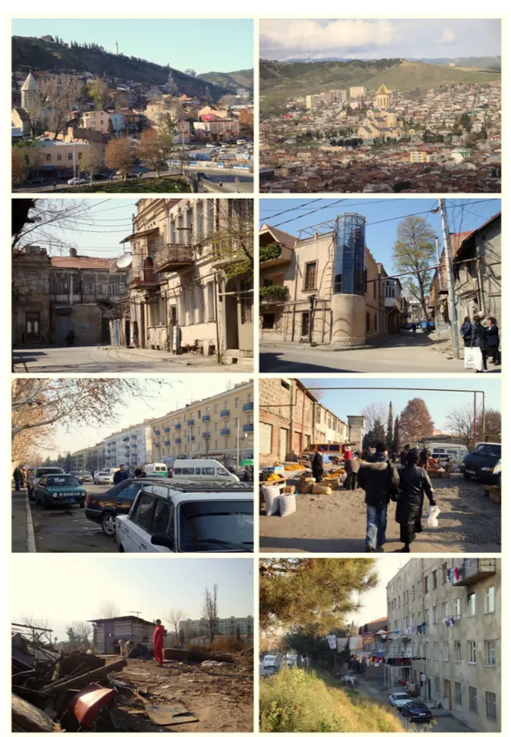
Illustration 3: Tbilisi 2009/2010 – Urban Areas and Special Districts
List of Figures
Illustration 2: Looking for Zone Specific Details Along the Nizami Street: Street Signs and Inscriptions
Fig. 1–2: Suburban Zone “Near the Breadfactory“, Source: Melanie Krebs, 2010/2011
Fig. 3–4: Residential Area “Around Landmark” – Late-Stalinist Apartment Blos, Source: Melanie Krebs, 2010/2011
Fig. 5–6: Urban Core Zone I – Reconstructing the Baku of the First Oil Boom (around 1900), Source: Melanie Krebs, 2010/2011
Fig. 7–8: Urban Core Zone II – e Baku of the Second Oil Boom Represents its Wealth, Source:
Melanie Krebs, 2010/2011
Illustration 3: Tbilisi 2009/2010 – Urban Areas and Special Districts Fig. 1: Old Inner City Area, Source: Madlen Pilz
Fig. 2: Cathedral of Holy Trinity, Sameba, Source: Madlen Pilz Fig. 3: Old Avlabari, Source: Madlen Pilz
Fig. 4: New Avlabari, Source: Madlen Pilz
Fig. 5: Tbilisi Residential Area, Source: Madlen Pilz Fig. 6: Market Area in an Old Mill, Source: Madlen Pilz Fig. 7: Scrap Trade Area, Source: Madlen Pilz
Fig. 8: Residential Area at the Urban Edge, Source: Madlen Pilz