Living with sea level change and coastal
flooding – Collective responses of households and communities in Indonesia
Lisa-Michéle Bott
Geographie
Living with sea level change and coastal flooding – Collective responses of households and
communities in Indonesia
I n a u g u r a l - D i s s e r t a t i o n zur
Erlangung des Doktorgrades
der Mathematisch-Naturwissenschaftlichen Fakultät der Universität zu Köln
vorgelegt von
Lisa-Michéle Bott
aus Halle (Saale)
Köln, 2020
Berichterstatter: Prof. Dr. Boris Braun Prof. Dr. Javier Revilla Diez Prof. Dr. Bill Pritchard
Tag der mündlichen Prüfung: 27. November 2019
III
It is not possible to write a PhD thesis and to do international research without having reliable social networks. Although it is impossible to acknowledge everybody who helped and supported me in Indonesia and Germany, I would like to thank you all and express my gratitude to some key individuals.
First of all, I thank the German Research Foundation (DFG) for funding this research under the Special Priority Program (SPP) 1889 ‘Regional Sea Level Change and Soci- ety’. The related research project is titled ‘Building adaptive capacity through translo- cal social capital – Sea level rise and resilience of coastal communities and households in Indonesia’ (TRANSOCAP). The main goal of the SPP-1889 is to enhance the un- derstanding of regional sea level changes and the related human-environment interac- tion in Southeast Asia and the North and Baltic Sea. Funding for a subsequent research phase (TRANSOCAP II) has already been granted by the DFG. I thank all partners within the SPP for their collaboration, especially Dr Tilo Schöne and Dr Julia Illigner from the German Research Centre for Geosciences (GFZ), Potsdam. This collaboration made it possible to combine results from geodetic sea level monitoring with socio- economic effects (cf. Bott et al. 2018, Chapter 3). Furthermore, worlds of thanks belong to the Graduate School of Geosciences (GSGS) for the provided training opportunities and the awarded travel grants.
My heartfelt thanks go to my supervisor Prof Dr Boris Braun. Thank you for your sup- port, our scientific discussions, for challenging me, and for traveling to Indonesia to support my field research. I am deeply thankful as well to my co-supervisor Prof Dr Bill Pritchard. Thank you for your comments, inputs, and for your encouragements. I am also very grateful to my co-supervisor Prof Dr Javier Revilla Diez. Thank you very much for your support and advice.
My deep gratitude goes to my colleagues at the Faculty of Geography at the Universitas
Gadjah Mada in Yogyakarta. I thank Prof Dr Muh. Aris Marfai for being a key research
partner. I also like to thank all his stuff members, among others: Citra Amalia Waskita
Sari, Dyah Fitria Dewi S.P., and Dr Estuning Tyas Wulan Mei. Likewise, I have to
IV
thank my colleagues at the Diponegoro University and the Department of Geography at the University of Indonesia. Thank you very much Dr Thomas Putranto, Dr Wi- wandari Handayani, Dr Eko Kusratmoko, Dr Muhammad Helmi, Nurrokhmah Rizqi- handari, and Nurul Sri Rahatiningtyas.
I furthermore thank all the Indonesian respondents who were so kind to invite me into their homes, to share their stories and experiences, and whose personal knowledge and contributions made this research possible. I would have loved to share so much more about the experiences I had during the field work, about the people I met, about kind- ness from strangers, and about the stories I heard. Your positivity moved me deeply.
Moreover, I thank all Indonesian student assistants who conducted the household sur- vey. I am very grateful to my senior assistants Laras, Desy, Lintang, and Annisa. Thank you so much for translating and explaining Indonesia to me and for your friendship.
Special thanks go to my student assistants in Cologne, as well. Thank you Carolina Kiesel and Konstantin Gisevius for your outstanding work within the project and thank you Tanja, Miriam, Frauke, Pia, and Kimberley. I am very grateful to all friends and colleagues who proofread my work: Dr Thomas Neise, Dr Alexander Follmann, Dr Hannes Laermanns, Susanne Weber, and I thank Regine Spohner for her amazing work on the figures and maps.
Having a good social network is key during the emotional sinus curve of writing a PhD.
Franziska Sohns, thank you for everything from curve discussions to after-work wine tasting. Thomas, Ayu, and Moritz, I thank you for a great time in Indonesia. Over the years, discussions over lunch and coffee breaks, as well as barbecues and karaoke nights, made long office days joyful: Thank you Alexander, Amelie, Birte, Carolin, Carolina, Fabian, Hannes, Holger, Jöran, Madlen, Melanie, Peter, Sebastian, Tanja, Thu, and Ulrike.
I thank my family for always believing in me and supporting me. I especially would
like to thank my mother for accompanying me to Indonesia and for sharing her impres-
sions on my study areas. I thank my siblings for cheering me up when I needed it and
my stepfathers for always being there for me. Finally, I thank Robin Niesters for sup-
porting me, proof-reading my work, and traveling with me. I am very happy to have
you in my life.
V
Responding to flooding and sea level change is a daily challenge for coastal populations worldwide. Filling knowledge gaps on how households and communities respond to these hazards is crucial to recognize the adaptation needs and capacities of exposed communities. This thesis presents the results of original, mixed-methods research (fo- cus group discussions and a standardized household survey) collected in Jakarta and the Semarang Bay area on Java, Indonesia. This study analyses the main question: How do households and communities respond to coastal hazards and what are their re- sources to self-organize and to act collectively? The adaptive capacity of communities, especially in the Global South, is critically related to social capital, as manifested through social networks, self-organization, and collective action. This thesis applies social capital first from a spatial perspective, focusing on local socio-spatial structures, and second, from a translocal perspective, analyzing boundary-crossing social net- works.
The results show that coastal hazards have become a normal element of live in the risk perception of local people. Rather than retreating or gaining permanent protection, peo- ple found ways to accommodate to and hence live with floods. This result adds an important dimension to the contemporary theorization of responding to coastal hazards.
Accommodating strategies, such as informal non-bank saving systems, are crucial for
people to maintain their livelihoods on a more substantial basis than recognized in
much of the literature. Furthermore, the findings demonstrate that social capital is sig-
nificantly shaped by the specific spatial forms of neighborhoods, particularly in the
presence and form of places to meet. The urban form of North Jakarta facilitates bond-
ing social capital, which enables the formation of responsive neighborhoods capable
of responding on mid-term scales. Bonding ties, together with attachment to place and
social belonging, appear to be key local assets for flood responses. However, there is
insufficient evidence to suggest that the current urban form of North Jakarta supports
the formation of adaptive neighborhoods in the long-term, which would require social
ties to the outside world. In this regard, the results on translocal social capital show
VI
that households with a higher number of translocal contacts are more likely to act pro- actively against coastal hazards. Furthermore, the propensity for translocal social cap- ital is economically stratified. Poorer households have fewer translocal ties, which im- pairs their adaptive capacities.
The results add to advancing the conceptualization of collective adaptation processes
and derive important policy implications. The thesis offers new insights into how com-
munity-based approaches can be better aligned with top-down strategies, one of the
biggest challenges for contemporary and future disaster risk reduction. Furthermore,
the findings provide new understanding into how the urban form of neighborhoods
influences the resulting social capital and adaptive capacities. Thus, a spatial perspec-
tive on collective hazard responses is important for urban planning to empower local
communities. Planning together with instead of just for hazard-affected communities
is the key to long-term and effective coastal adaptation.
VII
Meeresspiegelveränderungen und Überschwemmungen stellen eine tägliche Heraus- forderung für Küstenbevölkerungen weltweit dar. Wie Haushalte und Gemeinschaften mit diesen Gefahren umgehen, ist von entscheidender Bedeutung, um neue For- schungserkenntnisse über Anpassungsbedürfnisse und -kapazitäten der gefährdeten Gemeinschaften zu gewinnen. Für die vorliegende Dissertation wurden Primärdaten in Jakarta und der Semarangbucht auf Java, Indonesien, erhoben. Dabei kam ein Metho- denmix zum Einsatz, bestehend aus Fokusgruppen-Diskussionen und einer standardi- sierten Haushaltsbefragung. Diese Studie untersucht die Frage: Wie passen sich Haus- halte und Gemeinschaften an Küstengefahren an und welche Ressourcen stehen ihnen zur Selbstorganisation und zum gemeinschaftlichen Handeln zur Verfügung? Die An- passungsfähigkeit von Gemeinschaften, insbesondere im Globalen Süden, ist abhängig vom vorhandenen Sozialkapital, welches sich in sozialen Netzwerken, Selbstorganisa- tion und kollektivem Handeln manifestiert. In dieser Dissertation wird Sozialkapital zunächst aus einer lokal-räumlichen und anschließend aus einer translokalen Perspek- tive untersucht. Dabei werden lokale sozial-räumliche Strukturen und grenzüberschrei- tende soziale Netzwerke analysiert.
Die Ergebnisse zeigen, dass Küstengefahren in der Risikowahrnehmung der lokalen Bevölkerung zu etwas Alltäglichem geworden sind. Anstatt umzusiedeln oder perma- nenten Küstenschutz zu bekommen, finden die Menschen Wege mit den Überschwem- mungen zu leben. Anpassungsstrategien (accommodating), wie informelle Finanzin- strumente, tragen in weit substanziellerem Umfang zur Erhaltung der Lebensgrundlage der lokalen Bevölkerung bei als bislang von der wissenschaftlichen Literatur anerkannt wird. Darüber hinaus wird gezeigt, dass die spezifischen räumlichen Formen von Stadt- vierteln signifikant zur Entstehung des jeweiligen Sozialkapitals beitragen. Insbeson- dere das Vorhandensein und die Ausgestaltung von sozialen Treffpunkten ist hier maß- geblich. Die urbane Raumausstattung von Nordjakarta unterstützt die Entstehung von
„bonding“ Sozialkapital. Dieses fördert die Bildung von „responsive neighborhoods“,
VIII
die eine mittelfristige Anpassung ermöglichen. „Bonding“ Sozialkapital – im Zusam- menspiel mit Ortsgebundenheit und sozialer Zugehörigkeit – ist die wichtigste lokale Ressource für den Umgang mit Küstengefahren. Es gibt jedoch keine ausreichenden Belege dafür, dass die gegenwärtige urbane Form von Nordjakarta die Entstehung von
„adaptive neighborhoods“ unterstützt. Diese würden soziale Netzwerke zur Außenwelt erfordern, um eine langfriste Anpassung zu ermöglichen. Hierzu zeigen die Ergebnisse zum translokalen Sozialkapital, dass Haushalte mit einer höheren Anzahl an translo- kalen Kontakten mit einer größeren Wahrscheinlichkeit proaktiv gegen Küstengefah- ren vorgehen. Darüber hinaus ist die Entstehung von translokalem Sozialkapital öko- nomisch stratifiziert. Ärmere Haushalte haben weniger translokale Verbindungen, was ihre Anpassungsfähigkeit beeinträchtigt.
Die Ergebnisse tragen zu einer verbesserten Konzeptualisierung von kollektiven An-
passungsprozessen bei und dienen als Grundlage für politische Handlungsempfehlun-
gen. Die Arbeit bietet neuen Erkenntnisgewinn, wie Bottom-up-Ansätze besser mit
Top-down-Strategien abgestimmt werden können, eine der größten Herausforderungen
für die gegenwärtige und zukünftige Katastrophenvorsorge. Darüber hinaus liefern die
Ergebnisse neue Erkenntnisse darüber, wie die urbane Raumausstattung von Stadttei-
len das entstehende Sozialkapital und die Anpassungsfähigkeit beeinflusst. Eine räum-
liche Perspektive auf kollektive Anpassungsstrategien ist wichtig für Stadtplaner, um
lokale Gemeinschaften zu stärken. Gemeinsam mit den gefährdeten Gemeinschaften
zu planen – anstatt nur für sie – ist der Schlüssel zu einer langfristigen und effektiven
Küstenanpassung.
IX
Acknowledgments ... III Summary ... V Zusammenfassung ... VII Table of contents ... IX List of figures ... XII List of tables ... XIII List of abbrevations ... XIV
1 Introduction ... 2
1.1 Adaptation to coastal hazards... 5
1.2 Collective responses: Social capital and translocal networks ... 7
1.2.1 Social capital and spatial structures ... 7
1.2.2 Translocal social capital ... 8
1.3 Research questions and structure of the thesis ... 11
2 Research design ... 14
2.1 Sampling of case study areas on Java ... 14
2.2 Mixed-methods approach ... 18
2.2.1 Focus group discussions ... 18
2.2.2 Quantitative household survey ... 20
2.2.3 Cultural mapping ... 22
2.2.4 Final experts’ and practitioners’ workshop ... 23
2.2.5 Qualitative interviews ... 23
2.3 Ethical considerations ... 24
3 Sea level change, coastal flooding, and subsidence along the north coast of Java ...26
3.1 Relative sea level rise: Physical and anthropogenic processes ... 26
3.2 Socio-economic vulnerabilities and governmental disaster risk management ...33
4 How do households respond to coastal hazards? A framework for accommodating strategies using the example of Semarang Bay, Indonesia ... 39
4.1 Introduction ... 40
X
4.2 Response options to coastal hazards discussed in the literature ... 42
4.3 Concepts for analyzing the viability of response options to coastal hazards 44 4.4 Methods ... 46
4.5 Study area: The character of coastal hazards in the Semarang Bay area ... 48
4.6 Results ... 50
4.6.1 Strategies of retreat and protect in the Semarang Bay area ... 50
4.6.2 How do people accommodate coastal hazards? ... 52
4.7 Discussion: Establishing a new conceptualization of accommodating coastal hazards ... 56
4.8 Conclusion... 60
4.9 References ... 62
5 Adaptive neighborhoods: The interrelation of urban form, social capital, and responses to coastal hazards in Jakarta ... 68
5.1 Introduction ... 69
5.2 Literature review and hypotheses ... 71
5.3 Study area: North Jakarta ... 75
5.4 Methods ... 76
5.5 Results ... 79
5.5.1 Social capital and collective hazard response actions ... 79
5.5.2 Social capital and urban form ... 85
5.6 Discussion ... 92
5.7 Conclusion... 94
5.8 References ... 97
6 Translocal social capital as a resource for community-based responses to coastal flooding – Evidence from urban and rural areas on Java, Indonesia ... 101
6.1 Introduction ... 102
6.2 Translocal social capital ... 104
6.3 Study areas in North Java ... 108
6.4 Research methods ... 110
6.5 Results ... 112
6.5.1 Descriptive results on social capital and translocal social networks .. 112
6.5.2 The effects of translocal social contacts on adaptation to coastal hazards
……….113
XI
6.7 Conclusion... 123
6.8 References ... 124
7 Concluding discussion ... 130
7.1 Empirical contributions ... 130
7.2 Theoretical contributions ... 136
7.2.1 Adaptive neighborhoods ... 137
7.2.2 Social capital and translocal networks: The key to hazard risk reduction? ... 139
7.3 Policy implications ... 141
7.4 Limitations and outlook for further research ... 145
References for Chapters 1-3 & 7 ... 149
Appendix A: Supplementary material ... 157
Questionnaire for the FGDs ... 157
Household survey questionnaire ... 161
List of key informant and expert interviews ... 187
Appendix B: Own contribution... 188
Appendix C: Eigenständigkeitserklärung ... 190
XII
List of figures
Chapters 1-3
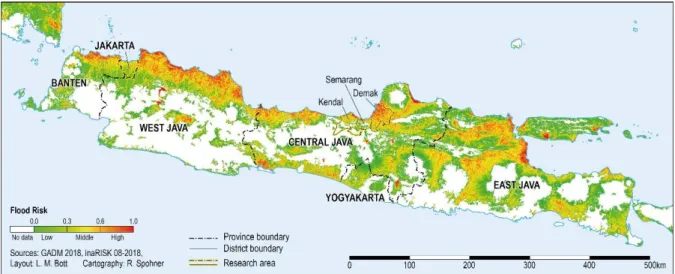
Figure 1: Risk towards tidal and rain/river floods on Java ... 5
Figure 2: Study areas and land-use patterns ... 17
Figure 3: Schematic overview of research phases, applied methods, and data analysis ... 18
Figure 4: Application of methods related to the respective research questions ... 22
Figure 5: Local sea level trend in Indonesia (1993-2015) ... 27
Figure 6: GNSS-tide gauge measurements in Semarang ... 28
Figure 7: Radar altimetry measurements near Semarang (1993-2017) ... 29
Chapter 4 Figure 1: The IPCC framework of responses to coastal hazards ... 43
Figure 2: Study areas and land-use in the Semarang Bay area ... 48
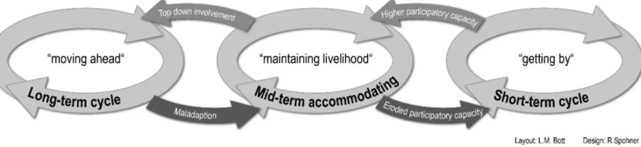
Figure 3: Response cycles of accommodating coastal hazards with up- and downscaling pathways ... 59
Chapter 5 Figure 1: Conceptual outline for the spatial dimensions of social capital ... 71
Figure 2: Flooding risks and location of study areas in North Jakarta ... 77
Figure 3: Methodological approach ... 78
Figure 4: Mapped research sites in North Jakarta ... 89
Chapter 6 Figure 1: Schematic of translocal social networks ... 105
Figure 2: Schematic framework of translocal social capital and responses to environmental change ... 107
Figure 3: Study areas and risk towards tidal and river flooding ... 111
Chapter 7
Figure 1: Types of neighborhoods in the context of hazard responses ... 138
XIII Chapter 4
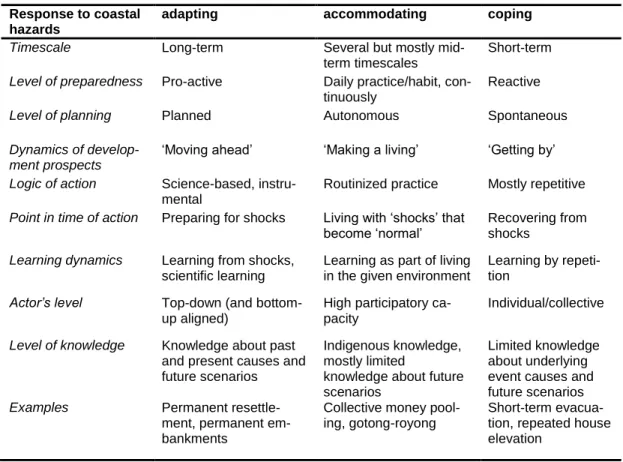
Table 1: Key distinctions in time & quality between adaption, accommodating, and coping ... 58 Chapter 5
Table 1: Independent variables ... 82 Table 2: Binary-logistic regression results for participating in collective hazard
response action ... 84 Chapter 6
Table 1: Bivariate relationships of proactive measure against flooding/house
elevation ... 114 Table 2: Definitions of dependent & independent variables ... 116 Table 3: Poisson regression results for the number of translocal contacts per
household ... 118
XIV
List of abbreviations
BAPPEDA Badan Perencanaan Pembangunan Daerah (District or Provin- cial Development Planning Agency)
BNPB Badan Nasional Penanggulangan Bencana (National Disaster Management Agency)
BPBD Badan Nasional Bencana Daerah (Regional Disaster Manage- ment Agency)
DFG Deutsche Forschungsgemeinschaft (German Research Founda- tion)
FGD Focus group discussions
GFZ German Research Centre for Geosciences GNSS Global Navigation Satellite System GSGS Graduate School of Geosciences
ICT Information and communication technologies IPCC Intergovernmental Panel on Climate Change NGO Non-governmental organization
RQ Research question
RT Rukun Tetangga (smaller neighborhood associations) RW Rukun Warga (larger neighborhood associations)
SPP Special Priority Program
UGM Gadjah Mada University
UI University of Indonesia
UNDIP Diponegoro University
VIF Variance inflation factors
1
ntroduction
1.1 Adaptation to coastal hazards
1.2 Collective responses: Social capital and translocal networks 1.3 Research objectives and structure of the thesis
I
2
1
1 Introduction
“Change is the only constant…” (Heraklitus)
Communities around the world are facing increasingly fast and complex changes in their surrounding socio-ecological systems (cf. Gallopín 2006; Wong et al. 2014). En- vironmental changes, such as sea level rise, occur at different scales (local, regional, and global) and within different timeframes, each of them bearing specific challenges for exposed local populations (cf. Bennet et al. 2016). Especially in many areas of the Global South, interrelated socio-economic and environmental changes, such as rapid urbanization, land-use changes, and sea level rise are occurring at unprecedented rates (cf. Conway et al. 2019).
Preparing for and responding to sea level change and coastal flooding is one of the major contemporary and future challenges for low-lying coastal areas around the world, including the coastlines of the Indonesian archipelago. Recent estimates from radar altimetry data predict an accelerated sea level rise over the 21
stcentury which would result in average sea level increases in the period to 2100 being twice as fast as current rates (Nerem et al. 2018). Thus, advanced understanding about human re- sponses and planning under uncertainty is urgently required to develop coastal risk reduction strategies in time as even best-case climate scenarios forecast drastic changes (IPCC 2014).
From a social science perspective, the impacts of such slow on-set events (sea level
changes in the range of mm per year) on human behaviors are not directly measurable
but require a long time series analysis (cf. Kunreuther et al. 2014). To enhance under-
standing about human responses towards possible future sea level changes, this thesis
therefore focusses on areas that are already highly affected by land subsidence and
resulting coastal flooding. The specific risk constellation of high subsidence rates
(changes in the range of cm per year) makes it possible to study human responses to
changing sea levels as if in a time-lapse and to gain empirical evidence on how people
respond to these socio-ecological challenges already today.
3
Within scientific debates about sea level changes, urban coastal areas are of central concern. It is here where impacts such as coastal flooding, erosion, and the resulting destruction of buildings and infrastructure are experienced, which makes human re- sponses to these local impacts inevitably place-specific (cf. Adger et al. 2011, Karlsson
& Hovelsrud 2015). Urban areas, especially in coastal regions, are thereby both drivers of and subject to environmental change and resulting coastal hazards (WBGU 2016).
As land subsidence is often amplified by anthropogenic impacts, such as large scale land-use changes, excessive ground water extraction, and high urban surface loads, ar- eas with the highest subsidence rates coincide with densely populated settlements (Bott et al. 2018, Marfai et al. 2015, Minderhoud et al. 2018). These processes result in an especially hazardous potential emerging from the interplay of climate-change induced sea level rise (partially in the future) and already existing land subsidence.
This interplay of human-induced and natural hazards in coastal zones is receiving in- creasing awareness and calls for new approaches in disaster risk reduction to system- atically manage and prevent the impacts of contemporary and future coastal hazards (e.g. Wong et al. 2014, Gill & Malamud 2017). These approaches include concepts, policies, and strategies to reduce exposure and vulnerabilities, to plan under uncer- tainty, to develop sustainable spatial planning and environmental management, and to enhance disaster preparedness (UNDRR 2017).
While disaster risk reduction policies are developed at international and national levels, the laboratories for disaster risk management and the implementation of strategies lie at municipal and communal levels in the exposed cities and villages (cf. WBGU 2016).
Here, the marginalized and poor population living on flood plains and along riverbanks are affected the most (cf. Leitner & Sheppard 2018). Especially in the Global South, these local households and communities often have to take on roles that would other- wise be the responsibilities of governmental disaster risk management agencies (Adger et al. 2003). Thus, local communities and households need to develop, organize and implement own bottom-up strategies to reduce risk and to live with floods and subsid- ence.
This thesis addresses these community-based hazard responses and adaptive capacities.
The overarching research question is: How do households and communities respond to
4
1
coastal hazards and what are their resources to self-organize and to act collectively?
Gaining better knowledge about households’ and communities’ socio-economic vul- nerabilities and adaptation pathways is crucial to understand drivers and barriers that enable or hamper coastal adaptation at the local level. The generated empirical evi- dence is used to advance the theoretical conceptualization of collective adaptation pro- cesses and to derive policy implications.
Research in coastal hazard-prone environments provides crucial knowledge about adaptive capacities and bottom-up response strategies that are not only relevant in the Indonesian context, but can contribute to advancing disaster risk reduction in local and regional contexts worldwide. Generating bottom-up insights is important to guide dis- aster risk reduction that meets the place-specific adaptation needs of local populations.
Applying this household and community-based perspective allows to focus on the ac- tive agency of local people, instead of depicting them as passive victims in the face of socio-ecological changes (cf. Waters & Adger 2017). Community responses have the potential to add a meaningful bottom-up perspective to the often top-down dominated approaches on disaster risk reduction and to substantially contribute to the success of governmental initiatives (Conway et al. 2019, Murphy 2007, Nakagawa & Shaw 2004).
New (soft) adaptation pathways might be identified in addition to engineering and tech- nical construction initiatives which municipal authorities often prioritize (cf. Koerth et al. 2013).
To this aim, this study presents the results of original, mixed-methods social science
research, collected in four different coastal hazards exposed urban and rural study areas
in North Java, Indonesia (fig 1). The megacity, Jakarta, and the Semarang Bay area are
prominent case study areas as these large urban agglomerations show some of the high-
est subsidence rates worldwide, with maximum subsidence values of 26 cm per annum
in Jakarta and 18 cm/a in Semarang (Marfai et al. 2015, Yastika et al. 2019). In conse-
quence, both regions are among the most affected ones by regional sea level change
and are highly exposed to frequent coastal flooding (fig 1). This already high flood risk
is likely to increase in the future (Hanson et al. 2011).
5
Figure 1: Risk towards tidal and rain/river floods on Java
This research was guided by two main conceptual approaches, i.e. (Chapter 1.1) adap- tation to coastal hazards and (Chapter 1.2) social capital and translocality. These con- cepts will be briefly introduced in the following and allow to derive the nuanced re- search questions formulated in 1.3.
1.1 Adaptation to coastal hazards
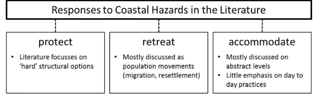
To advance the understanding of human responses to coastal hazards, the IPCC (2014)
has developed the tripartite framework of: (1) strategies of retreat, i.e. migration, relo-
cation of buildings and infrastructure, managed plot and river realignment, and setback
zones, (2) strategies of protect, e.g. dikes, seawalls, floodgates, dune restauration, and
mangrove reforestation, and (3) strategies of accommodating change, namely changes
in human activities, daily routines, and infrastructure (Wong et al. 2014). In this con-
text, so far, much attention has been placed on ‘big picture issues’ such as the debate
about climate-induced migration (inter alia: Baldwin & Fornalé 2017, Bettini 2014,
Ionesco et al. 2017, Piguet et al. 2011, Rothe 2017, Tacoli 2009, Trombetta 2014) or
large governmental prestige projects such as big seawalls (inter alia: Colven 2017, Su-
mantyo et al. 2016, van der Wulp et al. 2016).
6
1
However, these two strategies of retreating and structural protection do not reflect the realities and daily practices of most coastal populations. Despite their flood exposure, most coastal urban areas in the Global South are still gaining populations, a trend which is expected to further continue (Birkmann et al. 2010, McGranahan et al. 2007, Merkens et al. 2016, Neumann et al. 2015). Hence, local communities and households must have developed strategies to live with their hazardous environment and these community-based accommodating strategies can be assumed to be carried out to a much larger extent than commonly assumed in academic studies.
Yet, accommodating practices – in particular on the household and community level – remain largely under-emphasized in the scientific literature. This study addresses this research gap and examines how households and communities accommodate risks, and offers an empirical evidence-based conceptualization of accommodating practices (Chapter 4). Developing a modified framework allows to more firmly articulate ac- commodating practices and to include them in conceptual frameworks which guide further research. In this study, ‘human responses to coastal hazards’ are understood as an umbrella term for both short-term and recuperative coping as well as for long-term and proactive adaptation (cf. Gallopín 2006). Nevertheless, within the detailed analysis of accommodating processes, differentiations in timescale, quality, and agencies are applied to examine the viability of different hazard response options (Chapter 4).
Furthermore, empirical evidence of this study shows that the capacities of households and communities to carry out accommodating practices are dependent on their ability to self-organize and to act collectively. This is especially true for poorer communities faced with complex and slowly emerging risk constellation such as relative sea level rise along the north coast of Java. These communities often lack the financial and hu- man capital required for strategies of retreat and protection (cf. Koerth et al. 2014).
Thus, instead they change their daily practices and organize themselves, e.g. by in-
stalling collective informal non-bank saving systems or organizing collective waste
cleaning of dikes and ditches. This thesis, then, provides a practical and grounded lens
on the realities of living with sea level change and land subsidence by investigating
these capacities to act collectively with a focus on social capital and social networks
on different geographical scales.
7
1.2 Collective responses: Social capital and translocal networks
Many empirical studies have shown the importance of social capital in the collective adaptation processes of local communities and households (inter alia: Aldrich 2011, Chatterjee 2010, Murphy 2007, Portes 1998). In fact, social capital is assumed to be the most important capital endowment of local communities in the Global South (cf.
Braun & Aßheuer 2011). Through trust and reciprocal support, members of social net- works are able to secure benefits and to organize the access to tangible and intangible resources such as loans, remittances, mutual help, advice, information, and knowledge (cf. Kerr 2018, Portes 1998).
The overarching hypothesis of this study is that these assets have the potential to be- come valuable resources for disaster recovery, community adaptation, and long-term responses to natural hazards (cf. Aßheuer et al. 2013). Therefore, this study analyzes the role that social capital plays for collective hazard responses; thereby looking at the effects of local bonding social capital between largely homogeneous groups as well as of bridging and linking ties that connect people over different socio-economic and cul- tural backgrounds or even over different hierarchical social stratums (cf. Agurto Adri- anzén 2014, Lin 2008, Portes 1998). Former assumptions are investigated that bonding ties are more likely to support short-term coping practices and recovery, whereas the bridging and linking ties are essential for the innovation of ideas and long-term adap- tation (cf. Aßheuer 2014, Hawkins & Maurer 2010). To this aim, social networks are analyzed in different geographical scales, both with a local perspective on socio-spatial practices as well as with a perspective of border-crossing translocal ties.
1.2.1 Social capital and spatial structures
Firstly, this thesis applies social capital from a spatial perspective. Socio-spatial prac-
tices and structures still remain underestimated in hazard research, despite the signifi-
cance of social capital for community-based adaptation (cf. Acedo et al. 2017, Adger
et al. 2011, Marshall et al. 2012). This is surprising, as discussing such geographical
aspects of social capital is not new to social sciences, especially economic geography
8
1
(inter alia: Adger et al. 2003, Bathelt & Glückler 2018, Bærenholdt & Arsæther 2002, Boschma & Frenken 2006, Jacobs 1961, Lin & Lockwood 2014).
This study addresses this research gap with the aim to introduce the debate of socio- spatial practices into hazard research (Chapter 5). Based on former research by Adger et al. (2011), Houghton (2005), Spencer (2015), Wood & Giles-Corti (2008), the hy- pothesis is derived that a) the specific urban form of a neighborhood, especially in the presence and form of places to meet, is decisive for the probability of social encounters and dwell-time and, therefore, shaping social networks and b) that the emerging social capital is in turn decisive for collective adaptive capacities.
Drawing on concepts of economic geography on ‘knowledge neighborhoods’ and ‘ur- ban creative fields’ (Scott 2010, Spencer 2015), this thesis develops the concept of an
‘adaptive neighborhood’. Such a neighborhood resembles the ideal of a socio-spatial fabric with well-established social networks of all types (bonding, bridging, and link- ing) that allow for local self-organization and immediate mutual help, as well as for the exchange of new knowledge and innovative ideas. This concept contributes to a new understanding on how social networks are formed and why certain groups or individu- als are excluded or included. Furthermore, the results offer new guidelines for more sustainable urban planning.
1.2.2 Translocal social capital
Secondly, this study analyzes social capital from a translocal perspective. Spatially- anchored local bonding social capital plays a key role in the disaster recovery and haz- ard accommodating processes of vulnerable households and communities. However, in an ever more integrated world by globalization and technological innovations, social networks increasingly transcend the local and connect people from different places, regions, and countries (cf. Andersson et al. 2018, Boas 2017, Rockenbauch &
Sakdapolrak 2017). Despite this fact, most of the existing studies on the use of social
capital in adaptation processes have framed these processes in place-based ways,
thereby running the risk of underestimating the emergence of boundary-crossing, trans-
9
local social networks (inter alia: Adger 2003, Aldrich 2011, Aßheuer et al. 2013, Chat- terjee 2010). Likewise, most studies on translocality in anthropology, geography, cul- tural sciences, and population and development studies have not applied their ap- proaches in environmental and hazard research (inter alia: Brickell & Datta 2011, Etzold 2016, Greiner 2010, Steinbrink 2009, Verne 2012, Zoomers et al. 2016). A first exception is a recent publication by Rockenbauch and Sakdapolrak (2017), who com- bine insights from translocality and resilience studies.
This thesis aims at broadening this relatively narrow view of social capital in hazard and environmental change research; and develops the hypothesis that the response ca- pacity of local households and communities can be further enhanced by engaging in translocal social networks, which allow to overcome local resource constraints and to develop innovative ideas for proactive response measures (cf. Norris et al. 2008, Chap- ter 6). To this aim, this study conceptualizes social capital not only as a local but also as a translocal phenomenon and evaluates the significance of translocality for the use of social capital in hazard responses. Translocality here is understood as social net- works that extend over multi-scalar geographies and that support network members to circulate, to share common practices, and to exchange ideas and resources (Greiner &
Sakdapolrak 2013).
Adding this perspective of translocal social capital to hazard research allows to de- velop a more holistic conceptual framework to analyze resources, structures, and dy- namics of social networks of different scales. The concept offers numerous advantages for disaster risk reduction studies. It has an actor-oriented focus, emphasizes the im- portance of networks, shifts the focus away from the national state towards local pro- cesses, and enables researchers to analyze the formation of social capital beyond pro- cesses of human migration (e.g. by including communication technologies). Moreover, by explicitly focusing on local conditions, an emphasis is put on the physical environ- ment (cf. Greiner & Sakdapolrak 2013).
The combination of formerly separated branches of research offers critical new in-
sights. So far, social capital has been assumed to work as a substitute for lacking finan-
cial and human resources in poor communities (inter alia: Li et al. 2017, Nasution et
al. 2015, Rustiadi & Nasution 2017). However, insights from translocally studies have
10
1
indicated an important role of financial and human capital in establishing translocal social networks which is strongly shaped by practices such as migration, producing within global value chains, tourism, and the use of information and communication technologies (Etzold 2016, Freitag & Oppen 2010, Zoomers & van Westen 2011).
Therefore, the hypothesis is derived that a certain amount of financial assets and edu- cation are in fact required to engage in translocal networks and to build translocal social capital.
To capture the different local and translocal forms of social capital, this study applies a multi-place-based approach with a rural-urban perspective. In doing so, it is possible to adequately cover the specific roles of bonding, bridging, and linking ties. Tradition- ally, translocality research stemming from transnationalism approaches has focused on international relations, especially migration (e.g. Ley 2004, Levitt & Glick Schiller 2004, Smith 2001, Guarnizo & Smith 1998, Basch et al. 1995). However, more recent studies also focus on regional translocal spaces. Thereby, rural-urban interactions often represent particularly dynamic social linkages (Greiner & Sakdapolrak 2013).
In general, this study analyzes how both local and translocal social capital enables (or hampers) the endowed households and communities to live with coastal flooding and sea level change. The results lead to improved knowledge about bottom-up adaptation processes and local response capacities in times of rapid socio-environmental change.
Furthermore, this approach allows to analyze why vulnerabilities are unevenly distrib- uted even at the local level and why some households respond proactively while others do not (cf. Conway et al. 2019).
The results of this thesis add to moving forward the contemporary theorization of con- cepts that are important to advance in social science hazard research, namely accom- modating, adaptive neighborhoods, and translocal social capital. Embedded within the theorization of these three concepts lies the aim to better align community-based hazard responses with top-down governmental disaster risk reduction (cf. Koerth et al. 2014).
This is highly relevant as community-based responses tend to escape the purview of
policy makers who often plan for disaster risk reduction with limited understanding or
consideration of household response strategies, which in turn can lead to adverse ef-
11
fects such as maladaptation and social conflicts. Therefore, key parameters and path- ways for top-down interventions and the linking of top-down and bottom-up strategies are discussed with each concept. In that way, the findings of this thesis also aim to contribute to more sustainable coastal risk reduction which includes and empowers lo- cal communities.
1.3 Research questions and structure of the thesis
To analyze the outlined research gaps, this thesis draws on a multi-place-based case study of rural and urban areas along the north coast of Java, Indonesia, to answer the following main analytical research questions (RQs):
RQ 1: How do households and communities accommodate the uncertainties of coastal flooding and sea level change? Behind this question stands the hypothesis that local households and communities, instead of retreating or gaining permanent pro- tection, carry out accommodating strategies and slowly change their day-to-day prac- tices.
RQ 2: What strategies do communities apply to self-organize and to absorb the risk of coastal hazards? With this question, the hypothesis is investigated that high participatory capacities and traditions of self-organization enable local communities to accommodate their multi-risk environment.
RQ 3: What role does social capital play in collective responses of households and communities compared to other capital endowments? This question addresses two hypotheses: a) that social capital has a positive impact on collective bottom-up hazard responses, and b) that for collective responses of communities and households in the Global South, social capital tends to be more relevant than other forms of capital.
RQ 4: How is social capital interlinked with the urban form of neighborhoods
and what is the impact on the community’s response capacity towards coastal
hazards? Here, it is hypothesized that the formation of social capital as a resource for
hazard responses is partly determined by the specific urban form of the neighborhood.
12
1
RQ 5: What role do translocal social networks play for the responses of local households to coastal hazards, and how are these networks established? The two hypotheses entailed in this question are: a) that households with more translocal con- tacts are more likely to undertake proactive measures against coastal hazards and b) that, in contrast to local social capital, translocal social capital requires a significant amount of financial and human capital to be established.
The remaining six chapters of this thesis are structured in the following way: In the subsequent Chapter 2, the research design is described. Chapter 3 presents the multi- risk environment of the case study areas in more detail. This chapter elaborates on natural and anthropogenic processes contributing to sea level change and coastal flood- ing as well as on socio-economic and political factors, which add to vulnerabilities.
Chapters 4 to 6 each present individual research papers which analyze the central re- search questions named above. Consequently, each chapter entails a separate introduc- tion, theoretical framework, methods, discussion, and conclusion. Chapter 4, on ac- commodating strategies in the Semarang Bay area, analyzes community-based re- sponses to coastal hazards and establishes a new framework for the contemporary the- orization of accommodating. The two following chapters analyze social capital and networks with a primarily local (Chapter 5) and a broader translocal perspective (Chap- ter 6). Chapter 5 applies a local place-based focus on urban coastal neighborhoods in North Jakarta and examines the relationship between the urban form, social capital, and the resulting response capacities of these neighborhoods. In this chapter, the concept of an ideal adaptive neighborhood is developed. Chapter 6 then expands this local fo- cus to all rural and urban study areas and beyond by taking on a translocal perspective on social capital as a resource for hazard responses.
Finally, Chapter 7 answers the research questions and offers a broader discussion of
the empirical results and new conceptual frameworks with regard to theoretical contri-
butions and political implications. Furthermore, it discusses the limitations of this study
and provides recommendations for further research.
13
esearch design
2.1 Sampling of case study areas on Java 2.2 Mixed-methods approach
2.3 Ethical considerations
R
14
2
2 Research design
This study applies a case study approach (cf. Yin 2014). Case studies are beneficial in analyzing household and community-based hazard responses, as they provide the con- textualization for risk perceptions, problem articulations, and decision-making (cf.
Potschin & Haines-Young 2012). This chapter describes the research design of this study and explains the sampling of the study areas and the applied mixed-methods ap- proach.
2.1 Sampling of case study areas on Java
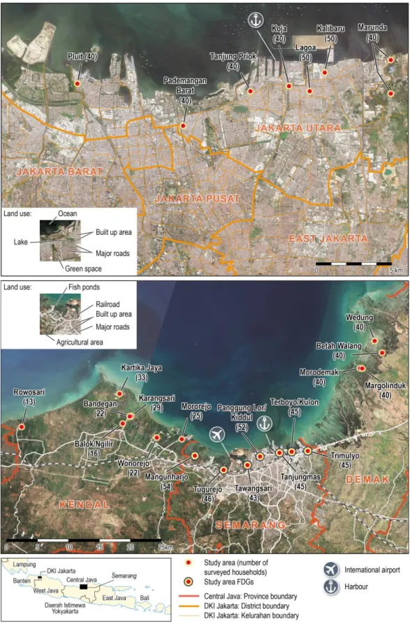
Given the translocal focus of this study, a multiple place-based approach is adopted, focusing on four different rural and urban locations. A multi-place-based analysis is useful in questions on translocal networks (RQ 5, Chapter 6) as it allows to analyze both ‘mobility’ and ‘places’ (cf. Zoomers & van Westen 2011). To gain a comprehen- sive picture of vulnerabilities and response capacities of households and communities towards current and future coastal flooding and sea level change (RQs 1 & 2), it is necessary to integrate both rural and urban settlements. This selection allows to analyze household and community-based hazard response strategies in regard to rural-urban livelihoods and different capital endowments (RQs 3 & 5).
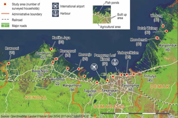
Thus, to inquire into adaptation processes, social networks, and migration patterns, I chose to analyze coastal settlements of different scales on Java, namely urban neigh- borhoods in the capital and megacity Jakarta and in the regional urban center Sema- rang, as well as neighborhoods in surrounding peri-urban villages in the district Kendal and rural villages in the district Demak. Together Kendal, Semarang, and Demak rep- resent the Semarang Bay area (fig 2).
Megacities such as Jakarta, with more than 10 mill inhabitants, are in the center of social science hazard research since these places combine high exposure with high an- thropogenic contributions to environmental changes (WBGU 2016, UN DESA 2019).
The reason to focus on a second-tier city, such as Semarang, is that many of these cities
15
are growing particularly fast. These cities can be seen as ‘emerging megacities’, with all the administrative thresholds that a mostly unplanned development entails, making them highly vulnerable towards natural hazards and sea level changes (Birkmann et al.
2016). A vulnerability which remains under-researched in comparison to the one of megacities. Only recently, second-tier cities have become a subject of renewed interest by scholars and development organizations (Roberts 2014).
Furthermore, this thesis includes peri-urban areas in the Kendal district, as these are faced by sub-industrialization and urban sprawl from the city of Semarang. These pro- cesses contribute to rapid land-use and environmental changes. In turn, rural areas, such as Demak, still remain less prioritized in coastal hazard research (Kapucu & Rivera 2013). However, in many countries of the Global South the share of population living in rural areas is still high and often growing. In Indonesia, a country with comparatively high urbanization levels, about half of the population still lives in rural areas (BPS 2014). These areas are often characterized by structural weaknesses and tend to be marginalized in governmental disaster risk reduction (Kapucu & Rivera 2013).
The specific neighborhoods and villages within all four study areas were chosen based on on-site inspections and in close collaboration with local research partners from the Faculty of Geography of Gadjah Mada University (UGM) in Yogyakarta, the Geology Department of Diponegoro University (UNDIP) in Semarang, and the Department of Geography of University of Indonesia (UI) in Jakarta.
Indonesian cities are structured in the following administrative units: Kota (city), fol- lowed by Kecamatan (district), Kelurahan/Desa (urban quarter/rural village), RWs (larger neighborhood associations, usually 5-10 per Kelurahan), and finally RTs (lower level neighborhood associations of about 40 to 60 households; Marfai et al. 2015). For the study at hand, I chose Kelurahan and Desa as the administrative units of analysis.
The criteria for the sampling of the specific Kelurahan and Desa were based on spatial
structures, land-use, and housing patterns, and on coastal hazards impacts. Selected
Kelurahan/Desa had to be located along the coastline and being influenced by coastal
hazards, at least by tidal floods and future sea level rise. All selected Kelurahan/Desa
are furthermore located on alluvial plains and, thus, are potentially prone to land sub-
sidence and rain/river flooding (fig 2). In terms of land-use, the areas had to be housing
16
2
areas with single unit houses, including neighborhoods with formal and unplanned res- idential statuses.
These criteria allow for a comparison between the Kelurahan/Desa based on similar natural hazards exposure and housing patterns. However, they cover different social, ethnical, and religious backgrounds, including lower and lower-middle income house- holds as well as long-term established and newer settlements. It was not possible to interview higher middle- or high-income residents, because people of a higher social stratum often tend to live in gated communities which cannot be accessed by the inter- viewers. Moreover, housing areas of higher-income residents are largely flood pro- tected and, hence, not in the focus of this study.
In total, seven Kelurahan were sampled along the coastline of Semarang during the first field research phase in 2016. They cover the major share of the coastal residential areas of the city (fig 2). In the second field research phase in 2017, I further selected the Kelurahan and Desa in Jakarta, Demak, and Kendal. The seven Kelurahan in Jakarta were selected based on the same criteria as in Semarang. In the rural areas, additional sampling criteria were applied. Rural villages in Demak had to be located at least 1.5 driving hours away from Semarang, to avoid daily commuter relationships and to en- sure rural livelihood patterns. Peri-urban villages in Kendal are, in turn, located in an area well connected to the City of Semarang by major roads and the railway (fig 2).
Industrial suburbanization towards this district is ongoing (cf. The Jakarta Post 2016).
17
Figure 2: Study areas and land-use patterns
18
2
2.2 Mixed-methods approach
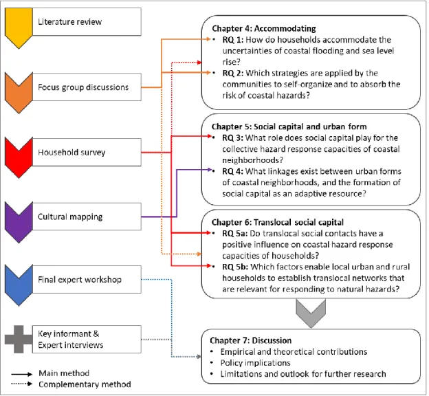
This study follows a mixed-methods social science approach (cf. Kelle 2014), consist- ing of focus group discussions (FGD) and a questionnaire household survey as the main instruments, supplemented by a final experts’ workshop, cultural mapping, and addi- tional key informant and expert interviews (fig 3 & 4). Qualitative and quantitative methods were conducted separately in different research phases; but the methods’ de- velopment builds on one another and the results were systematically triangulated.
A mixed-methods approach was chosen, as social capital and social networks of all scales are only measurable by indirect and disaggregated indicators. A combination of qualitative methods with a larger scale household survey provides a substantial ad- vantage for advancing in studies of adaptation processes (cf. Pelling & High 2005).
Figure 3: Schematic overview of research phases, applied methods, and data analysis
2.2.1 Focus group discussions
The first field research phase from August to September 2016 consisted of an explora- tive qualitative investigation in the Semarang area (fig 3). This phase entailed eight FGDs conducted at the community level. In this thesis, ‘community’ is understood synonymously with a spatial neighborhood unit. Members of one community are living in the same neighborhood, knowing one another, and sharing some degree of common perceptions and narratives about their surrounding socio-ecological environment (cf.
Murphy 2007). FGDs served as an entry point into the field research to gain first
knowledge about the communities under study, to further frame the research design,
19
and to develop the household survey questionnaire (cf. Flick 2014). This qualitative method is particularly valuable when discussing more ‘fuzzy’ aspects such as social norms and cognitive barriers which can be glossed over by standardized surveys. FGDs allow not only to gain relevant qualitative information but to analyze the interactions and communication patterns between participants (cf. Longhurst 2010). They are a fit- ting method in analyzing social norms, collective knowledge, and shared cultural em- beddedness all of which determine risk perceptions and institutions regulating collec- tive actions (cf. Flick 2014). Regarding the main research focus, this method is mainly suitable for analyzing social ties within networks where people personally know each other (local linkages but also family ties between different localities; RQs 1-3 & 5). A particular focus was laid on obtaining information about how people interact and col- laborate in local social networks, including resources that they share and relevant ways of communication.
The guideline questionnaire of the FGDs was developed based on an intensive litera- ture review and was structured in five sections which include questions on (1) commu- nity/household characteristics and livelihoods, (2) hazard exposure and risk percep- tions, (3) personal and collective hazard response strategies, (4) social capital, and (5) translocal and local social networks (see Appendix A).
I conducted the FGDs with the assistance of three students from UGM to reduce lan- guage and cultural barriers. I conducted one female only and one male only FGD. How- ever, as the results turned out very similar, the other FGDs were conducted with mixed- gender participants. Each FGD had seven to eleven participants, with a total of 29 fe- male and 46 male discussants from seven urban quarters in Semarang.
Qualitative results were translated and transcribed with the help of the local field assis- tants. The data analysis was oriented on a qualitative content analysis (cf. Mayring 2004). For the detailed analysis, an open coding system was applied using MAXQDA.
In doing so, patterns and connections between statements were identified and linked
into categories (cf. Bryman 2008).
20
2
2.2.2 Quantitative household survey
Based on a former literature review and on the qualitative results, I subsequently de- veloped the questionnaire for the household survey, structured in the same five sections as the FGD guideline questionnaire. Developing a questionnaire based on literature review, such as the World Bank Social Capital Assessment Tool (Krishna & Uphoff 1999), allows to include well-established indicators which enable future comparative studies. In addition, the qualitative results from the FGDs enabled the development of answer categories specific to the Javanese context. This procedure ensures both the comparability of the study as well as the explanatory power of the results for the spe- cific case study.
The household survey was carried out between March and May 2017. The quantitative survey targeted households within neighborhoods in all four study areas: Demak, Ken- dal, Semarang, and Jakarta. This method was chosen in order to gain detailed knowledge about vulnerabilities, hazard response strategies, and social networks not only regarding bonding, but also bridging and linking ties (RQ 1, 3 & 5). The survey includes questions about social networks and social capital such as collective ways of decision-making, close friends, family ties, links to other social groups, migration of household members, sources of financial support, participation in collective activities, and mutual help in times of crisis. Questions address issues such as trust in neighbors, relatives, NGOs, and local leaders as well as social norms, benefits, punishments, and social responsibilities. Further questions deal with coastal hazard response strategies, perceptions of hazard exposure, and knowledge about underlying physical and anthro- pogenic processes (see Appendix A).
Two teams of 15 and 16 student assistants from UGM, UI, and UNDIP conducted the survey in Indonesian under my supervision in the Semarang Bay area (Semarang, De- mak, and Kendal) and in Jakarta. Both interviewer teams were trained during three days’ kick-off workshops in each region. A pretest was conducted and evaluated at the beginning of March 2017 in Semarang.
In total 950 households were surveyed (not counting the pre-test), distributed between
the four study areas: Demak: n = 160, Kendal: n = 160, Semarang: n = 330, and Jakarta:
21
n = 300, representing 2 248 female and 2 122 male household members. The inter- viewed households were selected during random walks, choosing every fifth house on a street. The resulting answers were coded as numbers and entered by the research assistants into an English/Indonesian excel file. The respondents’ ratio female to male was close to 50/50. The survey targeted households as collective units of decision- making. In the questionnaire, household members were defined as all people who sleep and eat under the same roof a minimum of 180 days per year.
After finishing the subsequent data cleaning, I analyzed the quantitative data statisti- cally using STATA. Descriptive and bivariate analyses were used to obtain general weightings and first data overviews in all three research papers (Chapters 4-6) as well as to identify significant correlations between two variables, e.g. a correlation between participating in neighborhood meetings and participating in collective activities (RQ 2, Chapter 4); or correlations between different proactive hazard response measures and a high number of translocal contacts (RQ 5, Chapter 6). A more detailed understanding was obtained from multivariate analyses. A binary logistic regression analysis was ap- plied to identify the impact of social capital on collective adaptation measures (RQ 3, Chapter 5). A Poisson regression analysis was carried out to examine the origin of translocal social capital by using a dependent count variable of the number of translocal contacts a household has as the dependent variable (RQ 5, Chapter 6).
In the final data analysis, complementary results from the FGDs and the household
survey were used to gain a more comprehensive picture, e.g. the qualitative results
allow to analyze narratives about living in a multi-risk environment as well as agree-
ments and disagreements among the discussing community members, whereas quanti-
tative results enable to analyze the actual versus perceived hazard exposure. In addi-
tion, comparable results from both methods were triangulated to cross-check conver-
gent or divergent results and to achieve a higher validity of the research findings. Qual-
itative results helped to interpret significant statistical findings, and the quantitative
results supported qualitative findings with statistical numbers (see fig 4). The following
additional methods further complemented this mixed-methods approach (see fig 4).
22
2
Figure 4: Application of methods related to the respective research questions
2.2.3 Cultural mapping
To analyze the urban form of neighborhoods in the study areas in Jakarta, furthermore,
the results of cultural mapping are used with the aim to identify the spatial basis for the
emerging social capital (RQ 4, Chapter 5). This method is applied to explicitly visualize
socio-spatial relationships and practices (Sacco & Vella 2017). This particular method
was carried out by Leda Ankel during field research for her master’s thesis in close
collaboration with the TRANSOCAP research project (cf. Ankel 2018). Central re-
search questions and the classification of mapped places were developed based on the
23
household survey. The data analysis combines the results of both methods to answer questions about the urban form of public open spaces in coastal neighborhoods of Ja- karta (RQ 4).
2.2.4 Final experts’ and practitioners’ workshop
The validation of empirical results was further enhanced by presenting the findings at all three Indonesian partner universities and by conducting a final experts’ and practi- tioners’ workshop of the TRANSOCAP project in March 2018 in Semarang. Twenty local experts from academia, provincial and municipal government, and NGOs dis- cussed and commented on the empirical findings and debated potential implementation options. The aim was to gain feedback on the empirical results as well as to identify which aspects of this research are of particular concern from the perspective of local practitioners.
By conducting this participatory method, key findings were translated to practitioners.
That way, an interactive dialog was achieved with the goal to enable mutual benefits for both participants and researchers (cf. Preller et al. 2017). The results of these dis- cussions enabled the identification of cognitive barriers in top-down hazard planning and give insights into policy practices which support the final discussion of the research findings (Chapter 7).
2.2.5 Qualitative interviews
In addition to the principal research methods, I conducted eleven open qualitative in- terviews with local community leaders, municipal officials, university scholars, and hazard management agencies (see Annex A). The aim was to gain additional back- ground information on governance and top-down perspectives, which add to the com- munity- and household-based research design of this study. These interviews were ei- ther conducted directly in English or translated with the help of local student assistants.
The interviews were either recorded and transcribed in English, to allow for a content
analysis, or notes were taken during the interviews.
24
2
2.3 Ethical considerations
Prior to the interviews, all FGD participants were asked about their permission for re-
cording. They all gave their consent. The anonymity of all participants is guaranteed
by applying a numbering system in both quantitative and qualitative data analyses and
in the written version of the research results. Before starting the FGDs and the survey,
all participants were informed that they did not have to feel obligated to answer ques-
tions they did not feel comfortable with. After the publication of this thesis, the results
will be made available to participants who expressed their interest
25
ea level change, coastal flooding, and sub- sidence along the north coast of Java
3.1 Relative sea level rise: Physical and anthropogenic causes
3.2 Socio-economic vulnerabilities and governmental disaster risk management
S
26
3
3 Sea level change, coastal flooding, and subsidence along the north coast of Java
Urban coastal areas are at the center of political and scientific debates about global sea level rise and local hazard risk reduction. In these places, the negative effects become particularly visible, e.g. in the form of coastal flooding, erosion, and storm surges. Ja- karta has one of the highest urban flood risks worldwide, and the Semarang Bay area shows similar exposure (Abidin et al. 2013, Hanson et al. 2011). Over the last decades, both Jakarta and Semarang have undergone a rapid population increase, reaching 10 mill and 1.5 mill inhabitants respectively in the core municipal areas alone (Gar- schagen et al. 2018, Marfai & King 2008). Consequently, housing and economic activ- ities are sprawling into sensitive low-lying coastal zones and coastal flooding is be- coming ever more frequent (Garschagen et al. 2018, Neise 2019). Thus, current and future sea level changes are becoming an immense challenge for municipal planning agencies as well as for the inhabitants of coastal neighborhoods.
To analyze the main research questions regarding human hazard responses, first, these underlying natural and anthropogenic processes need to be understood. To this aim, this chapter addresses relevant socio-environmental processes within the study areas in North Java. The following questions are discussed: Which coastal hazards affect the north coast of Java? How do natural and anthropogenic processes contribute to sea level rise? What socio-economic and political factors add to human exposure?
3.1 Relative sea level rise: Physical and anthropogenic processes
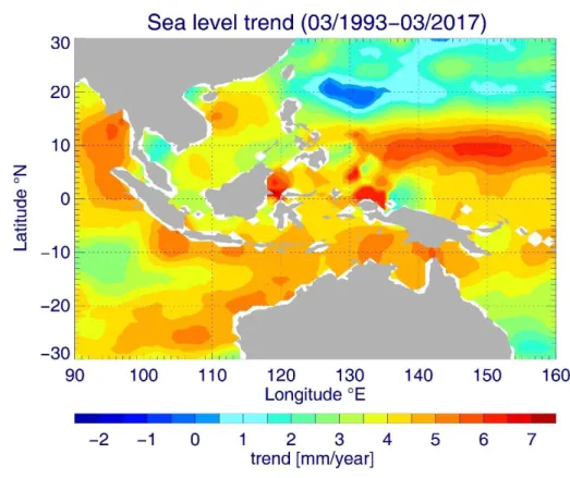
Globally, the average sea level is currently rising by 3.1 to 3.5 mm/a (Esselborn &
Schöne 2012, Kusche et al. 2016). However, there are strong regional variances.
Throughout the Indonesian archipelago, local sea level changes show rates between
-5 mm/a and +10 mm/a (Bott et al. 2018, fig 5).
27
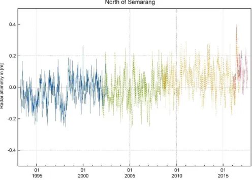
For the north coast of Java, data from both Global Navigation Satellite System (GNSS)- controlled tide gauge stations and radar altimetry show no significant trend in the ab- solute sea level change (Bott et al. 2018). These combined measurements are necessary, as radar altimetry data can only be obtained at 10 to 30 km distance from the coastlines because radar signals illuminate about 10 km diameters of sea surface. Hence, in coastal areas, these raster contain reflections of land masses which interfere with the sea surface signal (Kusche et al. 2016).
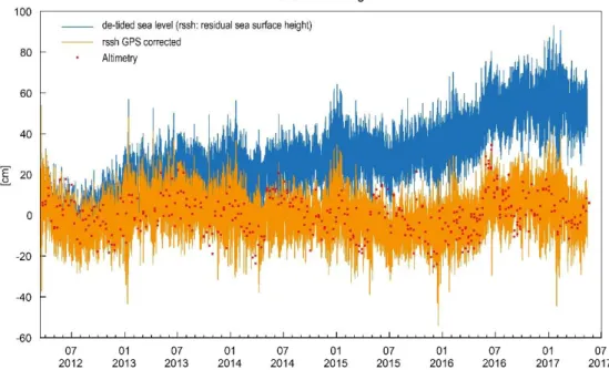
1Thus, tide gauges are required to obtain water- level data directly at the coastline. Within these stations, first, the water level sensors measure the water levels in relation to the tide gauge station. Second, at GNSS-con- trolled stations, the GNSS antenna on the roof of the station measures the vertical po- sition of the building, which allows to calculate the influence of land movements. The combined GNSS-tide gauge measurements then allow for the analytical distinction be- tween sea level change and subsidence or heaving of the land mass.
Figure 5: Local sea level trend in Indonesia (1993-2015) Source: edited after GFZ Potsdam in Bott et al. 2018: 5.
1